Meeting of the Planning Commission February 9, 2021 Planning Commission to be held February 9, 2021 with Social Distancing Modifications Public comment will be allowed via telephone; no in-person input will be allowed. All speakers, including applicants and representatives, must register in advance (Day before the scheduled meeting, February 8, 2021 by noon). To speak remotely at the February 9, 2021 Planning Commission Meeting, residents must: Preferably email the board liaison at andrew.rivera@austintexas.gov or call 512-974-6508 the day before the meeting. The following information is required: 1. The speaker name. 2. Item number(s) they wish to speak on. 3. Whether they are for/against/neutral. 4. Mailing address. 5. Telephone number. Must be the number that will be used to call-in. Failure to provide the required information by noon February 8, 2021 shall render a request null and void. A registered speaker may not sign up another speaker. Previous registration on an item does not automatically roll over. •Once a request to register to speak has been called in or emailed to the board liaison, residents will receive either an email or phone call with additional information regarding the call in process. •Handouts or other information must be emailed to andrew.rivera@austintexas.gov by 1:00 PM Tuesday, February 9, 2021 This information will be provided to Commission members in advance of the meeting. •Residents may watch the meeting here: http://www.austintexas.gov/page/watch-atxn-live Postponement requests must be submitted to the case manager and Andrew Rivera by 5PM Monday, February 8, 2021 Reunión de la Comisión de Planificación Fecha 9 de febrero de 2021 La Comisión de Planificación se reunirá el 9 de febrero de 2021 con modificaciones de distanciamiento social. Se permitirán comentarios públicos por teléfono; no se permitirá ninguna entrada en persona. Llame o envíe un correo electrónico al enlace de la junta en 512-974-6508 andrew.rivera@austintexas.gov a más tardar al mediodía (el día antes de la reunion, 8 de febrerode 2021). 1. El nombre del orador. 2. Número (s) de artículo sobre el que desean hablar. 3. Si están a favor / en contra / neutrales. 4. Dirección postal. 5. Número de teléfono. Debe ser el número que se utilizará para llamar a la persona que desea hablar. Si la información solicitada no se envía antes del mediodía del 8 de febrero de 2021, la solicitud será nula y sin efecto. Un orador registrado no puede registrar a otro orador. El registro anterior de un artículo …
ZONING CHANGE REVIEW SHEET CASE: C14-2020-0135.SH DISTRICT: 3 ZONING FROM: SF-3-NP TO: SF-6-CO-NP ADDRESS: 4908 Lott Avenue, 5000-5106 Lightfield Lane, & 1160-1166 Mason Avenue SITE AREA: 5.01 acres PROPERTY OWNER: 4908 Lott Holdings, LLC (Matt McDonnell) AGENT: Armbrust & Brown, PLLC (Michael Whellan) CASE MANAGER: Heather Chaffin (512-974-2122, heather.chaffin@austintexas.gov) STAFF RECOMMENDATION: Staff supports the Applicant’s request for rezoning to townhouse/condominium residential-conditional overlay-neighborhood plan (SF-6-CO-NP) combining district zoning. The conditional overlay will limit impervious cover to 51% exclusive of any shared-use path that allows public access to Springdale Neighborhood Park. For a summary of the basis of staff’s recommendation, see case manager comments on page 2. PLANNING COMMISSION ACTION / RECOMMENDATION: February 9, 2021: January 26, 2021: To grant postponement to February 9, 2021, as requested by neighborhood, on consent. (11-0) CITY COUNCIL ACTION: February 18, 2021: ORDINANCE NUMBER: 1 of 17B-2 C14-2020-0135.SH 2 ISSUES The proposed rezoning is for a 5.01 acre tract that was platted for 31 single family and duplex residential units in 2019. Please see Exhibit C- Approved Plat. The property changed hands in September 2020; the new owner is proposing 55 townhouse/condominium residential units. The applicant has provided a SMART Housing letter stating that 5 ownership units will be included at 80% of Median Family Income (MFI) for 99 years. Please see Exhibit D- SMART Housing Letter. CASE MANAGER COMMENTS: The rezoning tract is located northeast of the intersection of Lott Avenue and Mason Avenue in the MLK-183 area of the East MLK Combined Neighborhood Planning Area (NPA). The property is undeveloped and zoned SF-3-NP. Immediately north of the property is Springdale Neighborhood Park, which is zoned P-NP. The eastern boundary is Fort Branch Creek, and properties to the east are zoned SF-3-NP. While some of these properties are undeveloped because of their location in the floodplain, others in the area are developed with single family residences. Further to the east, on Delano Street and Jackie Robinson Street are properties zoned SF-6-NP and SF-6-CO-NP. South and southwest of the rezoning tract is a single family neighborhood zoned SF-3-NP. A single SF-6-NP tract is located in the vicinity and appears to be developed with a single family residence. To the west and northwest of the rezoning tract are single family residences zoned SF-3-NP. Further west, along Webberville Road, is a mix of SF-3-NP and GR-MU-NP zoned properties, including single family and multifamily properties, as well as a …
ZONING CHANGE REVIEW SHEET CASE: C14-2020-0135.SH DISTRICT: 3 ZONING FROM: SF-3-NP TO: SF-6-CO-NP ADDRESS: 4908 Lott Avenue, 5000-5106 Lightfield Lane, & 1160-1166 Mason Avenue SITE AREA: 5.01 acres PROPERTY OWNER: 4908 Lott Holdings, LLC (Matt McDonnell) AGENT: Armbrust & Brown, PLLC (Michael Whellan) CASE MANAGER: Heather Chaffin (512-974-2122, heather.chaffin@austintexas.gov) STAFF RECOMMENDATION: Staff supports the Applicant’s request for rezoning to townhouse/condominium residential-conditional overlay-neighborhood plan (SF-6-CO-NP) combining district zoning. The conditional overlay will limit impervious cover to 51% exclusive of any shared-use path that allows public access to Springdale Neighborhood Park. For a summary of the basis of staff’s recommendation, see case manager comments on page 2. PLANNING COMMISSION ACTION / RECOMMENDATION: February 9, 2021: January 26, 2021: To grant postponement to February 9, 2021, as requested by neighborhood, on consent. (11-0) CITY COUNCIL ACTION: February 18, 2021: ORDINANCE NUMBER: 1 of 17B-3 C14-2020-0135.SH 2 ISSUES The proposed rezoning is for a 5.01 acre tract that was platted for 31 single family and duplex residential units in 2019. Please see Exhibit C- Approved Plat. The property changed hands in September 2020; the new owner is proposing 55 townhouse/condominium residential units. The applicant has provided a SMART Housing letter stating that 5 ownership units will be included at 80% of Median Family Income (MFI) for 99 years. Please see Exhibit D- SMART Housing Letter. CASE MANAGER COMMENTS: The rezoning tract is located northeast of the intersection of Lott Avenue and Mason Avenue in the MLK-183 area of the East MLK Combined Neighborhood Planning Area (NPA). The property is undeveloped and zoned SF-3-NP. Immediately north of the property is Springdale Neighborhood Park, which is zoned P-NP. The eastern boundary is Fort Branch Creek, and properties to the east are zoned SF-3-NP. While some of these properties are undeveloped because of their location in the floodplain, others in the area are developed with single family residences. Further to the east, on Delano Street and Jackie Robinson Street are properties zoned SF-6-NP and SF-6-CO-NP. South and southwest of the rezoning tract is a single family neighborhood zoned SF-3-NP. A single SF-6-NP tract is located in the vicinity and appears to be developed with a single family residence. To the west and northwest of the rezoning tract are single family residences zoned SF-3-NP. Further west, along Webberville Road, is a mix of SF-3-NP and GR-MU-NP zoned properties, including single family and multifamily properties, as well as a …
ZONING CHANGE REVIEW SHEET CASE: C14-2009-0151(RCA3) – Shoal Creek Walk RCA PC DATE: February 9, 2021 ADDRESS: 835 West 6th Street DISTRICT: 9 SITE AREA: 2.6 acres (113,256 square feet) NEIGHBORHOOD PLAN AREA: Downtown Austin Plan (Market / Lamar) District PROPERTY OWNER: Shoal Creek Walk, LTD., (Richard W. Duggan III) AGENT: Armbrust and Brown, PLLC, (Amanda Surman) CASE MANAGER: Mark Graham (512-974-3574), mark.graham@austintexas.gov REQUEST: To amend a 2010 Restrictive Covenant to modify the condition that requires installing a 10,000 square foot green roof, and a 10,000-gallon rain water collection tank and associated equipment to irrigate the green roof. SUMMARY STAFF RECOMMENDATION: Staff recommends granting a third Amendment to the Restrictive Covenant as requested by the Applicant. PLANNING COMMISSION ACTION: February 9, 2021: CITY COUNCIL ACTION: March 4, 2021: RESTRICTIVE COVENANT AMENDMENT RECORDING NUMBER: ISSUES: No issues identified. CASE MANAGER COMMENTS: Applicant requests changing the Restrictive Covenant which requires installing a green roof and a 10,000-gallon rainwater storage tank with Phase II development. Instead, Applicant proposes to provide funding to the Shoal Creek Conservancy for a project that restores parapets and installs lighting to the 1887 West 6th Street historic limestone bridge over Shoal Creek. The proposed contribution would match a City of Austin Neighborhood Partnering 1 of 18B-4 C14-2009-0151(RCA3) Page 2 Program grant to do the work listed in the attached Shoal Creek Conservancy letter. Please refer to the Applicant’s proposed redlines to the Restrictive Covenant. The proposed Restrictive Covenant Amendment area is comprised of a 2.6-acre tract that contains commercial buildings and parking structure situated next to Shoal Creek Greenbelt hike and bike trail facilities. This amendment application proposes to modify the covenant recorded in Office of Public Records of Travis County, Texas as Document 2010083202 and later amended in Documents 2013085495 and 2014188351. Phase I of the development included two buildings: 225,000 sq. ft. of administrative offices - and 6,790 sq. ft. of retail space. Phase II of the development, currently under construction, will add another 150,000 sq. ft. of administrative offices. EXISTING ZONING AND LAND USES: LAND USES Office Office, retail (Whole Foods) Shoal Creek Greenbelt, Commercial Commercial, residential towers, greenbelt ZONING DMU-CURE Site West DMU East South DMU, DMU-CURE-CO, P, DMU, CBD-CO P, CBD-CO North DMU ABUTTING STREETS AND TRANSIT: Office Street Name West 6th Street West 5th Street ROW Pavement Classification Sidewalks Level 3 93 Level 3 72 50’ 50’ Yes, both sides #4, 5, …
MEMORANDUM TO: Chair and Members of the Planning Commission FROM: Andrei Lubomudrov Housing and Planning Department DATE: January 25, 2021 RE: Proposed annexation of 36 properties (approximately 115.4 acres) into Travis County Water Control and Improvement District No. 10 (District) C12M-2020-0137 On November 19, 2020, the City received an application requesting the City’s consent to the annexation of approximately 115.4 acres into Travis County Water Control and Improvement District No. 10 (District). The subject tracts are located south of Barton Creek Road approximately 2,000 to 2,500 feet southwest of the intersection of Canyon Rim Drive and FM 2244 in Austin’s extraterritorial jurisdiction (ETJ) and in the Barton Creek Watershed. The District includes properties in western Travis County and is located in the City of Austin’s ETJ. A map identifying the tracts to be annexed into the District and its location relative to existing District boundaries and City jurisdictions is attached. The assigned case number is C12M-2020- 0137. Applicant’s Proposal The 36 properties requesting annexation are currently served by the Camelot Water Supply Corporation, which was formed to serve the Lower Camelot neighborhood and now purchases water from Travis County WCID 10 as a wholesale customer. In light of aging infrastructure, the properties served by Camelot have entered into an agreement with the District to be annexed and receive upgraded infrastructure as fully annexed ratepayers. The annexation would also enable the installation of high-pressure fire hydrants, which would be valuable in mitigating potential damage from wildfires in the area. Representatives of the property owners appeared before the District’s Board of Directors at its meeting on March 11, 2020, and the District Board approved the annexation request contingent upon receiving the City’s approval of the District’s annexation of the property. 1 1 of 4B-5 • • • • • • City Review Process The Agreement Concerning Creation of the Travis County Water Control and Improvement District No. 10 (Consent Agreement) requires City approval for the annexation of land by the District. The District is considered a “noncity service district” and as such, the City is not authorized to place restrictions or conditions on this consent. If the City fails or refuses to consent within 90 days of receipt of a written request, the owner may petition the City to make available those services to be provided by the District. Failure to execute a mutually agreeable contract for services within 120 days constitutes …
PLANNING COMMISSION SITE PLAN CONDITIONAL USE PERMIT REVIEW SHEET PC DATE: 02/09/21 SPC-2009-0199D(R2) 2401 Holly St, Austin, TX 78702 MWM Design (Shari Pape) 305 E Huntland Drive Austin, TX 78758 (512) 689-3289 City of Austin (D’Anne Williams – Parks and Recreation Department) 919 W 28th Half Street Austin, TX 78705 (512) 974-9456 CASE NUMBER: PROJECT NAME: Holly Street Plant Decommissioning and Demolition Revision ADDRESS: APPLICANT: AGENT: CASE MANAGER: Renee Johns, (512) 974-2711 or renee.johns@austintexas.gov WATERSHED: NEIGHBORHOOD PLAN: Holly Neighborhood Plan PROJECT DESCRIPTION: The applicant proposes a revision to an existing site plan. The original site plan decommissioned and demolished portions of the existing Power Plant located on site. The revision to this site plan proposes to add a new use to the site: Community Recreation (Public) by adding 3,000 feet of trail to the existing hike/bike trail, revegetate portions of the site and other associated improvements. This will be done through a Memorandum of Understanding (MOU) between Austin Energy and the Parks and Recreation Department. SUMMARY STAFF RECOMMENDATION: Staff recommends approval of the Conditional Use Permit. The site plan will comply with all requirements of the Land Development Code prior to its release. SUMMARY STAFF COMMENT ON SITE PLAN: The applicant proposes a revision to an existing site plan to add 3,000 feet of trail to the existing hike and bike trail. Sites zoned Public (P) greater than one acre in size are a Conditional Use that require Land Use Commission approval according to Land Development Code section 25-2-625. Lady Bird Lake (Urban) 938,358 752 SF, 21.54acres P-NP (Public) Community Recreation (Public) 326,463 SF, 34.8% PROJECT INFORMATION: SITE AREA ZONING PROPOSED NEW USE PROPOSED IMPERVIOUS COVER NEIGHBORHOOD ORGANIZATIONS: Austin Independent School District Austin Lost and Found Pets Austin Neighborhoods Council Bike Austin Crossing Garden Home Owners Assn. (The) Del Valle Community Coalition East Austin Conservancy East Riverside/Oltorf Neighborhood Plan Contact Team East Town Lake Citizens Neighborhood Association El Concilio Mexican-American Neighborhoods Friends of Austin Neighborhoods Friends of Riverside ATX Neighborhood Association Greater East Austin Neighborhood Association Guadalupe Neighborhood Development Corporation 1 of 7B-6 SPC-2009-0199D(R2) Holly Street Plant Decommissioning and Demolition Homeless Neighborhood Association Neighborhood Empowerment Foundation Neighbors United for Progress Pleasant Valley Preservation Austin SELTexas Sierra Club, Austin Regional Group Southeast Austin Neighborhood Alliance Tejano Town Waterfront Condominium Homeowners Association Page 2 CONDITIONAL USE PERMIT REVIEW AND EVALUATION CRITERIA The following evaluation is included to provide staff position on each …
CASE NUMBER: PROJECT NAME: ADDRESS: APPLICANT: PLANNING COMMISISON SITE PLAN – COMPATIBILITY VARIANCES ONLY SP-2020-0282C PLANNING COMMISSION HEARING DATE: February 9, 2021 Austin ENT South Clinic 6503 Menchaca Road Attn: Dr. Taylor H. Shepard ENT Real Estate, LP 3106 Harris Blvd. Austin, TX 78703 (512) 444-7944 (512) 400-4207 Randall Rouda Randall.Rouda@austintexas.gov Baeza Engineering, PLLC 9701 Brodie Lane #203 Austin, TX 78748 AGENT: CASE MANAGER: NEIGHBORHOOD PLAN: Garrison Park Area PROPOSED DEVELOPMENT: The applicant is proposing to develop two vacant lots, zoned LO-NP (Limited Office – Neighborhood Plan) into a two story medical office building with ground floor parking. Total gross floor area is 9,850 square feet, with a total of 50 parking spaces (including 2 ADA spaces) and a bike rack. The site will have a single driveway accessing Menchaca Road. Public sidewalk improvements are proposed along Menchaca Road. One variance from compatibility setback requirements is being requested. DESCRIPTION OF VARIANCE: (512) 974-3338 1) From 25 feet to seven feet for the easterly setback. [LDC § 25-2-1063] SUMMARY STAFF RECOMMENDATION: The applicant proposes to place a variety of drainage and water quality improvements within the 25 foot compatibility setback. The encroaching improvements are all flush to the ground. The drainage improvements begin at the easterly edge of the building, approximately 33 feet west of the property line and extend over the compatibility setback. With the exception of the pond outlet structure, all drainage and water quality improvements are a minimum of 15 feet from the adjacent properties and are screened from view by a raised berm and landscaping. The outlet structure is built into the easterly slope of the berm at approximately seven feet from the property line and is screened from view with landscaping. In total, approximately 325 square feet of concrete and gravel improvements are located within the compatibility setback. There are two SF-3NP zoned parcels adjacent to the compatibility setback. One adjacent parcel is developed with a single story religious assembly (church) use. The other adjacent property is developed with a single family residence. That residence is located toward the front of the parcel where it does not appear to directly overlook location of the proposed drainage facilities. 1 of 6B-7 0.739 acres 32,191 sq. ft. LO-NP LO-NP Williamson Creek (Suburban) Comprehensive Watershed Ordinance The proposed medical office is an allowed use in the LO-NP Zone. The use and form – being two-story construction with adequate parking, …
SUBDIVISION REVIEW SHEET LOT(S): 8 PC DATE: Feb. 9, 2021 COUNTY: Williamson CASE NO.: C8-2020-0255.0A SUBDIVISION NAME: Avery Lakeline Final Plat AREA: 97.21 ac. OWNER: Lakeline Avery Partners, LP (Alex Clarke) AGENT/APPLICANT: John A. Alvarez, P.E. (Jones Carter, Inc.) ADDRESS OF SUBDIVISION: 14121 N US Hwy 183 WATERSHED: Buttercup Creek & South Brushy Creek EXISTING ZONING: CH-CS-MU-MF-4 PROPOSED LAND USE: Multifamily, Commercial-Retail, Commercial-Office, Assisted Living and Open Space DEPARTMENT COMMENTS: The request is for the approval of Avery Lakeline Final Plat, an 8 lot subdivision on a 97.24 acre tract containing 2 lots commercial (34.99 ac), 4 lots multifamily (46.89 ac) and 2 lots for parkland (11.00 ac) with 4.33 acres dedicated for ROW with associated water, wastewater, paving, drainage and water quality facilities. STAFF RECOMMENDATION: Staff recommends disapproval with reasons based on the unaddressed review comments in the attached, initial Master Comment Report. ZONING AND PLATTING COMMISSION ACTION: CASE MANAGER: Joey de la Garza EMAIL: joey.delagarza@austintexas.gov PHONE: 512-974-2664 1 of 6B-8 2 of 6B-8 S 2 0 ° 4 5 ' 0 2 " E 9 0 6 . 5 6 ' 30 BLOCK 1 29 28 C A N N O N M A R K W A Y 27 26 TEXAS PARKS AND WILDLIFE DEPARTMENT (6.177 ACRES) DOC. NO. 2012082085 O.P.R.W.C.T. Y E 1 V 5 R U O . 5 L S U T N A C L S A R E T A S A R H B C A 3 C LOT 3 BLOCK C MULTIFAMILY 11.13 AC. 6 ' 5 ' 0 1 . 3 3 ° E " 4 1 8 1 N 6 25 BLOCK 1 24 S 2 0 ° 4 5 ' 4 3 " E 8 1 5 . 0 5 ' LOT 4 BLOCK C MULTIFAMILY 12.00 AC. S87°38'10"W 435.52' L1 S88°04'17"W 534.02' STATE OF TEXAS STATE DEPARTMENT OF HIGHWAYS AND PUBLIC TRANSPORTATION (REMAINDER 789.508 ACRES) VOL. 1723, PAGE 855 D.R.W.C.T. 23 22 BLOCK 1 21 20 19 AVERY STATION SECTION 1A, PHASE 1 DOC. NO. 2011052951 O.P.R.W.C.T. 18 17 C A N N O N M A R K W A Y M O N T O U R D R I V E 14 15 16 BLOCK 1 AVERY STATION SECTION 1A, PHASE 1 DOC. NO. 2011052951 O.P.R.W.C.T. 3 BLOCK 1 2 4 6 8 7 S A X E T , L L I …
SUBDIVISION REVIEW SHEET LOT(S): 68 PC DATE: Feb. 9, 2021 COUNTY: Travis CASE NO.: C8-2020-0037 SUBDIVISION NAME: Marshall Ranch Preliminary Plan AREA: 37.23 ac. OWNER: Eanes Marshall Ranch, LP (Linda K. Haines) AGENT/APPLICANT: Jonathan Fleming (KTCivil) ADDRESS OF SUBDIVISION: 1300 Lost Creek Blvd WATERSHED: Eanes Creek & Barton Creek EXISTING ZONING: SF-2 PROPOSED LAND USE: Single-family, and Open Space DEPARTMENT COMMENTS: The request is for the approval of the Marshall Ranch Preliminary Plan, a development of a 37.23 acre tract containing 63 lots of single-family residential (16.36 ac), 1 lot private parkland (existing cemetery; 0.22 ac), 3 lots for drainage pedestrian access & PUE (15.62 ac) and 1 public lot (0.71 ac) with 4.32 acres dedicated for public ROW with associated water, wastewater, paving, drainage and water quality facilities. STAFF RECOMMENDATION: Staff recommends disapproval with reasons based on the outstanding review comments in the attached, initial Master Comment Report. ZONING AND PLATTING COMMISSION ACTION: CASE MANAGER: Joey de la Garza EMAIL: joey.delagarza@austintexas.gov PHONE: 512-974-2664 1 of 8B-9 E G E RID L T S A C R O O M T R A D LA S C I MA S WHITEMARSH VALLEY N O Y N A N C D I A I N WORCHESTER Q U A K E R R I D G E DIA M O N D H E A D d x m . p a M n o i t a c o L e t i S - t c a r T l l a h s r a M \ s t i b h x E S G \ I i \ t c a r T l l a h s r a M - 1 0 0 0 2 B C M \ e n o t s e l i \ M T C E J O R P \ : L : g n w a r D i SUBJECT SITE S S A R G W A S A R R O N I M I N K KIT T A N S E T T C A P I T A L O C F A T P E I T X A A L S O F T E X A S K E E R T C S O L F O X C H A P E L B A Y …
SUBDIVISION REVIEW SHEET LOT(S): 8 COUNTY: Williamson PC DATE: Jan. 12, 2021 CASE NO.: C8-2019-0057.1A SUBDIVISION NAME: Pearson Ranch West Phase One Subdivision AREA: 40.544 ac. OWNER: Pearson Ranch, LLC (Brett Ames) AGENT/APPLICANT: Brian Grace, P.E. (BGE, Inc.) ADDRESS OF SUBDIVISION: 14320 RR 620 WATERSHED: Lake Creek EXISTING ZONING: GR-MU PROPOSED LAND USE: Multifamily, ROW and Parkland DEPARTMENT COMMENTS: The request is for the approval of the Pearson Ranch West Phase One Subdivision which will create an 8 lot mixed-use subdivision on 40.544 acres with 2 lots of Commercial/Multi-Family (12.95 acres), 1 lot for access drives (1.49 acres), ROW dedication (4.96 acres) and 5 ETJ lots (21.14 acres) with all associated improvements. STAFF RECOMMENDATION: Staff recommends disapproval with reasons for this subdivision plat based on the outstanding review comments in the attached, first Master Comment Report. PLANNING COMMISSION ACTION: CASE MANAGER: Joey de la Garza EMAIL: joey.delagarza@austintexas.gov PHONE: 512-974-2664 1 of 10B-10 PEARSON RANCH WEST - PHASE 1 LOCATION MAP 10/27/2020 N A M D O O G J : y B M P 6 2 : 0 4 : 5 0 2 0 2 / 7 2 / 0 1 : d e t t l o P 1 t u o y a L : t u o y a L . g w d P A M N O T A C O L I i 6 2 - 6 0 - 0 2 0 2 \ s t i b h x E _ 5 0 \ D D A C _ 1 0 \ D L \ 1 - H P - h c n a R - n o s r a e P - 0 0 - 1 7 6 7 \ C L L h c n a R _ n o s r a e P \ s t c e o r P C X T \ j \ : G BGE, INC. 1701 DIRECTORS BOULEVARD, SUITE 1000 AUSTIN, TX 78744 TBPE Registration No. F-1046 TEL: 512-879-0400 www.browngay.com 2 of 10B-10 “ ” “ ” “ ” “ ” “ ” “ “ “ “ “ “ “ “ “ “ “ “ “ ” “ ” ” ” ” ” ” ” ” ” ” ” ” ” “ “ ” ” “ ” “ “ ” ” “ ” BGE, Inc. 7330 San Pedro Ave, Suite 202 San …
M E M O R A N D U M Andrew Rivera, Planning and Zoning Department TO: FROM: DATE: January 29, 2021 SUBJECT: Street Right-of-Way Vacation Application for Chalmers Stephany Roy, Senior Property Agent, Land Management Development Services Department Avenue (F#10245-2002) Attached are the departmental comments and other information pertinent to the referenced right of way vacation. The owner, Housing Authority City of Austin (HACA) is asking for the vacation to further enhance their affordable housing project, provide a more continuous play area for the children, and increase pedestrian and bicycle connectivity in the neighborhood. HACA is tearing down the older buildings and increasing their unit count from 158 to 398. The proposed vacation tract is currently associated with an active site plan, # SP-2020-0004C. All affected departments and private utility franchise stakeholders have reviewed the request and recommend approval, subject to the conditions on the Master Comment Report. A Public Utility Easement (PUE) and Access Easement will be retained over the entirety of the ROW vacation area. Land Management is requesting that this item be submitted for placement on the February 9, 2021 Planning Commission Agenda for their consideration. The applicant and/or their representative will be at the meeting. Staff contact: Mashell Smith 512-914-4455 and Stephany Roy at 404-357-1814 or landmanagement@austintexas.gov Applicant: Meg Greenfield, Dunaway Associates 512-306-7240; mgreenfield@dunawayassociates.com Property Owner: Housing Authority of Austin (HACA) Stephany Roy, Senior Property Agent Land Management Development Services Department Attachment - Info Packet: Master Comment Report, Intro letter, Application, Survey, Location Map 1 of 28B-11 CITY OF AUSTIN - R.O.W. VACATION MASTER COMMENT REPORT As of: November 19, 2020 PROJECT NUMBER: 2020-084690 LM PROJECT NAME: 10245-2002 Chalmers Ave (Previously File No. 10245-2001) LOCATION: CHALMERS AVE, AUSTIN, TX Review Dept. LM AT&T (SWBT) Rejected Reviewer Phone Attempt Date Approved Date Comments: AT&T requires their facilities be relocated first before they can approve the vacation request. Lucy Cabading 512-974-9241 07/14/2020 "I can approve this after the AT&T facilities have been relocated, if I have a statement stating the vacation won't go into effect until after the facilities have been relocated." Approved With Conditions Lucy Cabading 512-974-9241 10/09/2020 10/09/2020 Comments: I accept the vacation of the ROW as long as we have a 10¿ easement in place to allow maintenance and placement of our facilities. & ENGRG DESIGN 817 W. North Loop Austin, TX 78756 737 255-4856 Thank you, David A. Williams LEAD OSP PLNG & …
M E M O R A N D U M Andrew Rivera, Planning and Zoning Department Stephany Roy, Senior Property Agent, Land Management Development Services Department TO: FROM: DATE: January 29, 2021 SUBJECT: Alley Right-of-Way Vacation Application for 2209 S. 1st Street (F#10350-2010) Attached are the departmental comments and other information pertinent to the referenced right of way vacation. The owner, RPC South First St, LLC is asking for the vacation to allow a mixed-use project, with live-work units and multifamily units. The proposed vacation tract is currently associated with an active site plan, # SP-2020-0351C.CP. All affected departments and private utility franchise stakeholders have reviewed the request and recommend approval, subject to the conditions on the Master Comment Report. A Public Utility Easement (PUE) and Drainage Easement will be retained over the entirety of the ROW vacation area. Land Management is requesting that this item be submitted for placement on the February 9, 2021 Planning Commission Agenda for their consideration. The applicant and/or their representative will be at the meeting. Staff contact: Mashell Smith 512-914-4455 and Stephany Roy at 404-357-1814 or landmanagement@austintexas.gov Applicant: James M. Schissler, Civilitude, LLC 512-761-6161; jim@civilitude.com Property Owner: RPC South First St, LLC Stephany Roy, Senior Property Agent Land Management Development Services Department Attachment - Info Packet: Master Comment Report, Intro letter, Application, Survey, Location Map B-12 CITY OF AUSTIN - R.O.W. VACATION MASTER COMMENT REPORT As of: November 23, 2020 PROJECT NUMBER: 2020-162621 LM PROJECT NAME: [10350-2010] 2209 S 1st Street LOCATION: 2209 S 1ST ST, AUSTIN, TX 78704 Review Dept. LM AT&T (SWBT) Approved Comments: LM ATD Review Approved Approved Thank you, Rikki Benevides she/her/hers MGR OSP PLNG & ENGRG DESIGN NETWORK ENGINEERING & OPERATIONS Austin-South M: 512.771.4961 Reviewer Phone Attempt Date Approved Date Lucy Cabading 11/16/2020 11/16/2020 Comments: After reviewing this request with the Director of the Austin Transportation Department, ATD approves of the alley right-of-way vacation. Ravi Dhamrat 512-974-1217 11/17/2020 11/17/2020 11/23/20 73002_f_lm_master_report Page 1 B-12 As of: November 23, 2020 PROJECT NUMBER: 2020-162621 LM PROJECT NAME: [10350-2010] 2209 S 1st Street LOCATION: 2209 S 1ST ST, AUSTIN, TX 78704 Review Dept. Reviewer Phone Attempt Date Approved Date LM Austin Resource Recovery Review Approved Michael Zavala (512) 974-1837 11/18/2020 11/18/2020 Comments: Do not see any issues with this vacation that would hinder any ARR services in this area. LM AW Infrastructure Management Approved With Conditions Eric Sermeno 512-972-0497 11/13/2020 11/13/2020 Comments: …
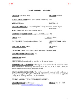
SUBDIVISION REVIEW SHEET LUC DATE: 2/9/2021 CASE NO.: C8J-2018-0091.2A SUBDIVISION NAME: Turners Crossing North Phase 2 AREA: 100.665 acres OWNER/APPLICANT: Meritage Homes of Texas, LLC (Matthew Scrivener) AGENT: Kimley-Horn and Associates, Inc. (Jacob Kondo) ADDRESS OF SUBDIVISION: Approx. FM 1327 at N Turnersville Road GRIDS: G-8 WATERSHED: Rinard Creek COUNTY: Travis LOT(S): 304 JURISDICTION: 2-Mile ETJ MUD: N/A EXISTING ZONING: N/A PROPOSED LAND USE: Single Family, Commercial, Drainage, Landscape, Park ADMINISTRATIVE WAIVERS: N/A VARIANCES: None SIDEWALKS: Sidewalks will be provided on all internal streets. DEPARTMENT COMMENTS: The request is for approval with conditions of Turners Crossing North Phase Two Subdivision consisting of 304 lots on 100.665 acres. Water and wastewater will be provided by the City of Austin. STAFF RECOMMENDATION: The staff recommends approval with conditions of this final plat. The attached report details the conditions and the plat will be back for final approval when conditions are clear. ZONING AND PLATTING COMMISSION ACTION: CASE MANAGER: Sarah Sumner Email address: sarah.sumner@traviscountytx.gov PHONE: 512-854-7687 1 1 of 10B-13 2 of 10B-13 3 of 10B-13 4 of 10B-13 5 of 10B-13 6 of 10B-13 7 of 10B-13 8 of 10B-13 9 of 10B-13 Turner’s Crossing North Phase 2 Location Map 10 of 10B-13
CITY OF AUSTIN – TRAVIS COUNTY – SINGLE SUBDIVISION OFFICE SUBDIVISION APPLICATION – MASTER COMMENT REPORT U1 512-854-7687 Turners Crossing North - Phase 2 13023 N TURNERSVILLE RD C8J-2018-0091.2A UPDATE: 00 Sarah Sumner PHONE #: CASE NUMBER: REVISION #: CASE MANAGER: PROJECT NAME: LOCATION: SUBMITTAL DATE: January 25, 2021 REPORT DUE DATE: February 8, 2021 FINAL REPORT DATE: February 3, 2021 STAFF REPORT: This report includes all staff comments received to date concerning your most recent subdivision application submittal. The comments may include requirements, recommendations, or information. The requirements in this report must be addressed by an updated submittal. The subdivision application will be approved when all requirements from each review discipline have been addressed. However, until this happens, your application is considered disapproved. Additional comments may be generated as a result of information or design changes provided in your update. If you have any questions, problems, concerns, or if you require additional information about this report, please do not hesitate to contact your case manager at the phone number listed above or by writing to the City of Austin, Development Services Department, P.O. Box 1088, Austin, Texas 78767. UPDATE DEADLINE (LDC 30-2-56; 30-2-82): It is the responsibility of the applicant or their agent to update this subdivision application. The final update to clear all comments must be submitted by the update deadline, which is March 15, 2021. Otherwise, the application will automatically be denied. If this date falls on a weekend or City of Austin holiday, the next City of Austin workday will be the deadline. UPDATE SUBMITTALS: An update submittal is required. Please submit 1.0 of the plans and 1.0 copies of a letter that address each comment for distribution to the following reviewers. Clearly label information or packets with the reviewer’s name that are intended for specific reviewers. No distribution is required for the Planner 1. Updates may be submitted between the hours of 8:30 am and 4:00 pm. Updates submitted after 3 pm may be processed on the following business day. Please note: if Austin Water rejects a plan on Update 2, a fee is due at or before resubmittal. Please contact Intake for the fee amount. REVIEWERS: Site Plan Plumbing : Cory Harmon Drainage Engineering : Kyle Virr Water Quality : Kyle Virr Electric Review - Andrea Katz - 512-322-6957 Comments cleared. 911 Addressing Review - Jorge Perdomo - 512-974-1620 AD 1 This plat review …
SUBDIVISION REVIEW SHEET LUC DATE: 2/9/2021 CASE NO.: C8J-2008-0176.01.8A SUBDIVISION NAME: Sun Chase South Section Eight AREA: 20.157 acres OWNER/APPLICANT: Qualico CR, LP (Vera Massaro) AGENT: Carlson Brigance & Doering, Inc. (Brian Kelling) ADDRESS OF SUBDIVISION: Sweet Mimosa Drive and Sparkling Light Drive GRIDS: R-11, R-12 WATERSHED: Dry Creek East COUNTY: Travis LOT(S): 91 JURISDICTION: Limited Purpose EXISTING ZONING: I-SF-4A MUD: Southeast Travis County MUD Number 1 PROPOSED LAND USE: Single Family, Sidewalk/Landscape ADMINISTRATIVE WAIVERS: Granted for cut and fill associated with water quality and detention facilities. VARIANCES: None SIDEWALKS: Sidewalks will be provided on all internal streets. DEPARTMENT COMMENTS: Requesting approval with conditions of Sun Chase South Section Eight Final Plat, consisting of 91 lots on 20.157 acres. Water and wastewater will be provided by the City of Austin. STAFF RECOMMENDATION: The staff recommends approval of this subdivision. This plan has outstanding conditions to be satisfied to meet all applicable County, State and City of Austin LDC requirements. ZONING AND PLATTING COMMISSION ACTION: CASE MANAGER: Sarah Sumner Email address: sarah.sumner@traviscountytx.gov PHONE: 512-854-7687 1 1 of 7B-14 2 of 7B-14 3 of 7B-14 4 of 7B-14 5 of 7B-14 6 of 7B-14 Sun Chase South Section 8 Location Map 7 of 7B-14
CITY OF AUSTIN – TRAVIS COUNTY – SINGLE SUBDIVISION OFFICE SUBDIVISION APPLICATION – MASTER COMMENT REPORT UPDATE: PHONE #: U0 512-854-7687 Sun Chase South Section 8 PEARCE LN C8J-2008-0176.01.8A 00 Sarah Sumner CASE NUMBER: REVISION #: CASE MANAGER: PROJECT NAME: LOCATION: SUBMITTAL DATE: January 11, 2021 REPORT DUE DATE: February 1, 2021 FINAL REPORT DATE: February 4, 2021(3 days have been added to the update deadline) STAFF REPORT: This report includes all staff comments received to date concerning your most recent subdivision application submittal. The comments may include requirements, recommendations, or information. The requirements in this report must be addressed by an updated submittal. The subdivision application will be approved when all requirements from each review discipline have been addressed. However, until this happens, your application is considered disapproved. Additional comments may be generated as a result of information or design changes provided in your update. If you have any questions, problems, concerns, or if you require additional information about this report, please do not hesitate to contact your case manager at the phone number listed above or by writing to the City of Austin, Development Services Department, P.O. Box 1088, Austin, Texas 78767. UPDATE DEADLINE (LDC 30-2-56; 30-2-82): It is the responsibility of the applicant or their agent to update this subdivision application. The final update to clear all comments must be submitted by the update deadline, which is April 15, 2021. Otherwise, the application will automatically be denied. If this date falls on a weekend or City of Austin holiday, the next City of Austin workday will be the deadline. UPDATE SUBMITTALS: A formal update submittal is required. You must make an appointment with the Intake Staff (974-2689) to submit the update. Please bring a copy of this report with you upon submittal to Intake. Please submit 4 copies of the plans and 4 copies of a letter that address each comment for distribution to the following reviewers. Clearly label information or packets with the reviewer’s name if intended for a specific reviewer. No distribution is required for the Planner 1. Updates may be submitted between the hours of 8:30 am and 4:00 pm. Updates submitted after 3 pm may be processed on the following business day. Please note: if Austin Water rejects a plan on Update 2, a fee is due at or before resubmittal. Please contact Intake for the fee amount. REVIEWERS: Planner 1: Elsa Garza …
February 2, 2021 Pio.Renteria@austintexas.gov Case Number SP-2019-0600C District-2. Scott Grantham Scott.Grantham@austintexas.gov South Congress Combined Neighborhood Plan Contact Team – SCCNPCT Notice of Public Hearing Site Plan Appeal for 4802 South Congress Avenue DATE: TO: CC: FROM: Re: SCCNPCT - Requesting Postponement Planning Commission February 09, 2021 Re: Applicant: Mike McHome Parks Department: Scott Grantham Scott.Grantham@austintexas.gov . Dear Scott Grantham, We, the SCCNPCT are requesting postponement February 9, 2021 Planning Commission for Case Number SP-2019- 0600C 4802 South Congress Avenue to March 9, 2021 Planning Commission. We the SCCNPCT will need time to communicate with the applicant Mike McHone for this Notice of Public Hearing Site Plan Appeal. We will consult with Scott Grantham from the Parks Department and the applicant as to the intent and specifics of this appeal for 4802 South Congress Avenue. Thank you, Mario Cantu, Keena Miller & SCCNPCT. Grantham, Scott From: Sent: To: Subject: kevin mackie <> Thursday, February 4, 2021 1:11 AM Grantham, Scott case # SP-2019-0600C *** External Email - Exercise Caution *** Hello Scott Grantham - I object to the exemption for case # SP-2019-0600C - Kevin Mackie (Mockingbird Lane) CAUTION: This email was received at the City of Austin, from an EXTERNAL source. Please use caution when clicking links or opening attachments. If you believe this to be a malicious and/or phishing email, please forward this email to cybersecurity@austintexas.gov. 1 Grantham, Scott From: Sent: To: Subject: Elizabeth Birns <> Wednesday, February 3, 2021 9:30 PM Grantham, Scott NO to the exemption for SP-2019-0600C *** External Email - Exercise Caution *** Scott As a resident on Hedgewood Drive, near Williamson Creek AND 4802 S. Congress, I wanted to let you know that I am very much opposed to the exemption for case # SP-2019-0600C. If you allow the park land access exemption in this case, you will be setting a horrible precedent. Allowing this exemption tells all future developers that they can promise whatever they need to in order to get approval for a permit to build. And they know that they won’t be held accountable and will only have to pay a fine to essentially do whatever they wanted to do in the first place. This is simply not acceptable, so please vote NO! on this exemption. Thank you for your time. Sincerely, Elizabeth Burns Sent from my iPhone CAUTION: This email was received at the City of Austin, from an EXTERNAL …
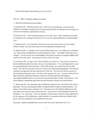
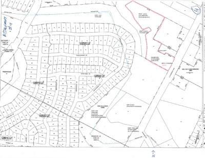
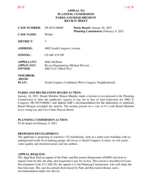
APPEAL TO PLANNING COMMISISON PARKLAND REQUIREMENT REVIEW SHEET 3 CS-MU-CO-NP 4802 South Congress Avenue South Congress Combined (West Congress Neighborhood) Parks Board: January 26, 2021 Planning Commission: February 9, 2021 Mike McHone Rivera Engineering (Michael Rivera) 4802 LLC (Mitch Ely) CASE NUMBER: SP-2019-0600C CASE NAME: Wilder DISTRICT: ADDRESS: ZONING: APPELLANT: APPLICANT: OWNER: NEIGHBOR- -HOOD PLAN: PARKS AND RECREATION BOARD ACTION: January 26, 2021: Board Member Mason-Murphy made a motion to recommend to the Planning Commission to deny the applicant's request to pay fee in lieu of land dedication for 4802 S. Congress (SP-2019-0600C) and uphold staff’s recommendation for the dedication of parkland; Board Morgan seconded the motion. The motion passed on a vote of 9-1 with Board Member Luca voting nay and Vice Chair Farasat absent. PLANNING COMMISSION ACTION: To be heard on February 9, 2021 PROPOSED DEVELOPMENT: The applicant is proposing to construct 125 multifamily units in a multi-story building with an underground multi-level parking garage, driveway to South Congress Avenue, on-site storm water quality and detention pond, and site utilities. APPEAL REQUEST: The Appellant filed an appeal of the Parks and Recreation Department (PARD) decision to require land for this site plan, and requested to pay fee in lieu. This action is described in Land Development Code 25-1-605 (F); the appeal is to the Planning Commission, who will make the final decision. The case has already been heard by Park and Recreation Board, and a recommendation made (see above). 1 of 31B-15 SP-2019-0600C Wilder SUMMARY STAFF RECOMMENDATION: Staff recommends upholding PARD’s original requirement to dedicate land as part of this site plan; and denial of the applicant’s request to pay fee in lieu. The criteria for the decision of whether to require land vs. fee in lieu are listed in 25-1-605. (B). In determining whether to require dedication of land under Section 25-1-602 (Dedication of Parkland) or allow payment of a fee in-lieu of dedication under this section, the director shall consider whether the subdivision or site plan: 2 (1) is located within the Deficient Park Area Map; (2) is adjacent to existing parkland; (3) has sufficient acreage to meet the standards for dedicated parkland under the Parkland (4) is needed to address a critical need for parkland or to remedy a deficiency identified Dedication Operating Procedures; by the Deficient Park Area Map; or (5) would provide increased connectivity with existing or planned parks or recreational amenities. These …
Austin Strategic Housing Blueprint Scorecard with HousingWorks Austin Agenda Blueprint Overview Goals Progress Insights Information Other Progress Blueprint Overview Blueprint Overview - Timeline 2018 2017 2019 • $250M Affordable •Austin Strategic •Bond, Blueprint & Housing General Obligation Bond Passes • Strategic Direction 2023 Housing Blueprint Adopted SD23 Implementation Adopted by Council 2020 • '18 & '19 Blueprint Scorecard • $300M Project Connect Anti- Displacement 4 Blueprint Overview – Document Purpose Establish Timeframe Outline Goals Build Partnerships Identify Resources Unify Strategy Align Plans 5 Blueprint Overview - Community Values Prevent Households from Being Priced Out of Austin Foster Equitable, Integrated and Diverse Communities Invest in Housing for Those Most in Need Create New and Affordable Housing Choices for All Austinites in All Parts of Austin Help Austinites Reduce their Household Costs 6 Blueprint Overview – Displacement Prevention People’s Plan 7 Goals Goals Goal 1 Goal 2 Goal 3 Goal 4 Goal 5 Goal 6 Goal 7 Distribute Across All 10 Districts 30% MFI and less 20K housing units 31 - 60% MFI 25K housing units 61 - 80% MFI 15K housing units 81 - 120% MFI 25K housing units 121% MFI and above 50K housing units Count & Track Housing by District 75% w/in 0.5mi of Imagine Austin Centers and Corridors 25% near High Opportunity Areas Preserve 10K affordable units over 10 years Create 1,000 Permanent Supportive Housing (PSH) / Continuum of Care (CoC) Units over 10 years 9 Progress 2019| Progress – Goal 1 – Affordable Units by District Information is for the 2019 calendar year reporting period. 11 2018 + 2019 Progress – Goal 2 & 3 = 135,000 Units in 10 Years Information is for the 2019 calendar year reporting period – chart includes both 2018 and 2019 progress. 12 2019| Progress – Goal 2 Only = Units at or below 80% MFI Information is for the 2019 calendar year reporting period. 13 2019| Progress – Goal 3 Only = Units above 81% MFI Information is for the 2019 calendar year reporting period. 14 2019| Progress – Goal 4 = Housing Units by District Data on the affordability of all housing units in Austin is not available annually. The City of Austin will have information responsive to this goal in 2023 when it conducts its next Comprehensive Housing Marketing Analysis, which is completed every five years and includes a comprehensive analysis of …
February 9, 2021 Planning Commission Speaker List Applicant - Leah Bojo B1 For Justin Morgan Opposed Gina Rogers Mario Cantu Applicant Michael Whellan B2/ B3 For Dick Hall Opposed David Boyle 917-349-2917 Ezra Brown Thomas Barker Antony McGregor Day Applicant Amanda Surman B-4 B-6 Applicant - Renaldo Hernandez Applicant Phillip Crisara Applicant - David Anderson Jim Schissler For William Sayers Applicant Mike Mchone B-11 B-12 B-15 For Michael Rivera Opposed Marion Cantu Gwen Jewiss Paul Mullen Steve Prather Nicole Joslin Shavonne Otero Marla Torrado Mary Olmstead
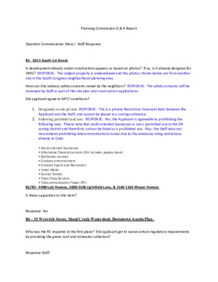
Planning Commission Q & A Report Question Commissioner Shaw / Staff Response B1- 6311 South 1st Street Is development already under construction-appears so based on photos? If so, is it already designed for VMU? RESPONSE: The subject property is undeveloped and the photos shown below are from another site in the South Congress neighborhood planning area. How can City address safety concerns raised by the neighbors? RESPONSE: The safety concerns will be reviewed by Staff as part of the site plan and construction applications. Did applicant agree to NPCT conditions? 1. Designated on-site pet area. RESPONSE: This is a private Restrictive Covenant item between the Applicant and the Staff, and cannot be placed in a zoning ordinance. 2. Following prohibited land uses: RESPONSE: Yes, the Applicant is agreeable to prohibiting the following uses. Please note that adult-oriented businesses is not a permitted use in the GR zoning district and therefore, cannot be listed as a prohibited use. Also, the Staff does not recommend prohibiting telecommunications tower due to the extensive siting restrictions already in Code. • Adult-oriented businesses • Alternative financial services (this includes payday loans) • Bail bonds services • Outdoor entertainment • Outdoor Sports and Recreation • Hotel-Motel • Service Station • Pawn Shop Services • Telecommunication Tower (PC) B2/B3 - 4908 Lott Avenue, 5000-5106 Lightfield Lane, & 1160-1166 Mason Avenue Is there opposition to this item? Response: Yes B4 - 35 West 6th Street, Shoal Creek Watershed; Downtown Austin Plan Why was the RC required in the first place? Did applicant get to waive certain regulatory requirements by providing the green roof and rainwater collection? Response Staff: When the applicant proposed to rezone the property from DMU to DMU-CURE in (Case # C14- 2009-0151 in November 2009), the City negotiated “community benefits” in conjunction with the modification of building height from the DMU maximum of 120’ to DMU-CURE height of 350’. The Design Commission outlined several benefits related to project design including building a green roof (please refer to attached memo). See, Exhibit Staff Response B-4 – Design Commission Memo B11 - Street Right-of-Way Vacation Application for Chalmers Avenue Has applicant agreed to all the conditions for approval from various City departments (e.g; Austin Water)? Applicant Response: Yes, we will comply with all conditions. As with AE, they all just wanted to be covered by an easement, which the City will retain, and be paid for any …
PLANNING COMMISSION February 9, 2021 MINUTES The Planning Commission convened in a meeting on February 9, 2021 via videoconference (http://www.austintexas.gov/page/watch-atxn-live) Chair Shaw called the Commission Meeting to order at 6:05 p.m. Commission Members in Attendance: Awais Azhar Joao Paulo Connolly Claire Hempel – Vice-Chair Yvette Flores Patrick Howard Carmen Llanes Pulido Robert Schneider Patricia Seeger James Shieh Todd Shaw – Chair Jeffrey Thompson Absent: Don Leighton-Burwell – Ex-Officio EXECUTIVE SESSION (No public discussion) The Planning Commission will announce it will go into Executive Session, if necessary, pursuant to Chapter 551 of the Texas Government Code, to receive advice from Legal Counsel on matters specifically listed on this agenda. The Commission may not conduct a closed meeting without the approval of the city attorney. Private Consultation with Attorney – Section 551.071 CITIZEN COMMUNICATIONS A. APPROVAL OF MINUTES 1. Approve the minutes of January 27, 2021. Motion to approve the minutes of January 27, 2021 was approved on the consent agenda on the motion by Commissioner Shieh, seconded by Commissioner Seeger on a vote of 11-0. Two vacancies on the Commission. B. PUBLIC HEARINGS 1 Rezoning: Location: C14-2020-0134 - 6311 South 1st Street; District 2 6311 South 1st Street, Williamson Creek Watershed; South Congress Combined (Sweetbriar) NP Area Owner/Applicant: ND South First LP (Haythem Dawlett) Agent: Request: Staff Rec.: Staff: Drenner Group PC (Leah M. Bojo) GR-MU-CO-NP to GR-MU-V-NP Recommendation of GR-MU-V-CO-NP Wendy Rhoades, 512-974-7719, wendy.rhoades@austintexas.gov Housing and Planning Department Public Hearing closed. Motion by Commissioner Azhar, seconded by Commissioner Connolly to grant Staff’s recommendation of GR-MU-VO-CO-NP combining district zoning for C14-2020-0134 - 6311 South 1st Street located at 6311 South 1st Street was approved on a vote of 11-0. Two vacancies on the Commission. Conditional Overlay: The following uses are not permitted uses of the Property: Alternative financial services Automotive sales Automotive washing (of any type) Bail bond services Hotel-motel Outdoor entertainment Outdoor sports and Recreation Pawn shop services Service station 2 Plan Amendment: NPA-2020-0015.04.SH - Lott Avenue; District 1 Location: 4908 Lott Ave; 5000-5016 Lightfield Ln; 1160-1166 Mason Ave, Fort Branch Watershed; East MLK Combined NP Area Owner/Applicant: 4908 Lott Holdings, LLC Agent: Request: Staff Rec.: Staff: (GMJ Real Estate Investments, LLC) (Matt McDonnell) Armbrust & Brown, PLLC (Michael J. Whellan) From Single Family to Higher Density Single Family Recommended Jeff Engstrom, 512-974-1621, jeffrey.engstrom@austintexas.gov Housing and Planning Department Public Hearing closed. Motion by Vice-Chair Hempel, seconded by Commissioner Connolly to …
ZONING CHANGE REVIEW SHEET CASE NUMBER: C14H-2020-0136 APPLICANT: Historic Landmark Commission HISTORIC NAME: Wyseacre, Ellen Wyse House WATERSHED: Shoal Creek HLC DATE: 8-24-2020, 9-28-2020, PC DATE: CC DATE: 10-26-2020, 11-16-2020 12-22-2020 TBD ADDRESS OF PROPOSED ZONING CHANGE: 2816 San Pedro Street ZONING CHANGE: SF-3-CO-NP to SF-3-CO-NP-H COUNCIL DISTRICT: 9 STAFF RECOMMENDATION: Recommend historic zoning based on the property’s historical associations and architecture. QUALIFICATIONS FOR LANDMARK DESIGNATION: Architecture, historical association HISTORIC LANDMARK COMMISSION ACTION: 8-24-2020: Initiated historic zoning. 9- 28-2020: City postponement request. 10-26-2020: Applicant postponement request. 11-16- 2020: Recommended historic zoning, 8-2-1; Commissioners Featherston and Papavasiliou opposed, Commissioner Jacobs off dais. PLANNING COMMISSION ACTION: N/A DEPARTMENT COMMENTS: N/A CITY COUNCIL DATE: N/A ACTION: N/A ORDINANCE READINGS: N/A ORDINANCE NUMBER: N/A CASE MANAGER: Kalan Contreras PHONE: 974-2727 NEIGHBORHOOD ORGANIZATION: Austin Independent School District, Austin Lost and Found Pets, Austin Neighborhoods Council, Bike Austin, CANPAC (Central Austin Neigh. Plan Area Committee), Central Austin Community Development Corporation, Central Austin Urbanists, Friends of Austin Neighborhoods, Homeless Neighborhood Association, Neighborhood Empowerment Foundation, Preservation Austin, SELTexas, Shoal Creek Conservancy, Shoal Crest Neighborhood Assn., Sierra Club, Austin Regional Group, University Area Partners, West Campus Neighborhood Association BASIS FOR RECOMMENDATION: Architecture: 2816 San Pedro is a 1.5-story stucco residence with rectangular Cape Cod plan. It is side-gabled, with a composite-shingle roof, three gabled dormers with 1:1 wood windows and lap siding, and a gabled portico supported by Classical columns. At the main elevation’s southern bay are 4:4 and 6:6 mulled windows framed with shutters. The northern bay contains a single 12:12 window with similar shutters. A fanlight and sidelights surround the inset door. A hipped-roof addition to the south has 2:2 windows and a secondary entry. Historical Associations: 2816 San Pedro Street was constructed for the Wyse family around 1924. William Riley Wyse, an independent oilman with ties to Austin’s power and water company, passed away shortly after its construction. Ellen Borroughs Wyse remained there with her son and daughter-in-law. 1 of 29B-5 Ellen Wyse was a prominent writer, editor, and business owner in Austin. Early in her career, Wyse served as the society editor for the Austin Statesman, then established the Gossip Advertising firm in 1911, beginning with a single-page newspaper insert. By the 1920s, Gossip had grown into a multi-page publication and household name. Gossip’s offices were located first at the Austin National Bank Building and later at the Scarbrough Building, as noted on its state …
Planning Commission: January 26, 2021 NEIGHBORHOOD PLAN AMENDMENT REVIEW SHEET DATE FILED: July 28, 2020 (In-cycle) NEIGHORHOOD PLAN: Montopolis CASE#: NPA-2020-0005.01 PROJECT NAME: Montopolis Acres PC DATE: January 26, 2021 January 12, 2021 December 22, 2020 1013 - 1017 Montopolis Dr. ADDRESSES: DISTRICT AREA: 3 SITE AREA: 3.13 acres OWNER/APPLICANT: Montopolis Acres, LP AGENT: Thrower Design (Ron Thrower and Victoria Haase) CASE MANAGER: Maureen Meredith, Housing and Planning Dept. PHONE: (512) 974-2695 STAFF EMAIL: Maureen.meredith@austintexas.gov TYPE OF AMENDMENT: Change in Future Land Use Designation From: Single Family Base District Zoning Change To: Multifamily Related Zoning Case: C14-2020-0029 From: SF-3-NP To: MF-6-NP NEIGHBORHOOD PLAN ADOPTION DATE: September 27, 2001 PLANNING COMMISSION RECOMMENDATION: January 26, 2021 - 1 NPA-2020-0005.01 1 of 21B-1 Planning Commission: January 26, 2021 January 12, 2021 – Postponed to January 26, 2021 on the consent agenda at the request of the Montopolis Neighborhood Plan Contact Team, applicant was in agreement. [J. Shieh – 1st; P. Seeger – 2nd] Vote: 12-0 [One vacancy]. December 22, 2020 - Postponed to January 12, 2021 on the consent agenda at the request of the Montopolis Neighborhood Plan Contact Team, applicant was in agreement. [A. Azhar – 1st; P. Seeger – 2nd] Vote: 11-0. [J. Shieh absent. One vacancy]. STAFF RECOMMENDATION: To grant the applicant’s request for Multifamily land use. BASIS FOR STAFF’S RECOMMENDATION: Staff supports the applicant’s request for Multifamily land use because the property is located on Montopolis Drive which is a major thoroughfare where multifamily uses are appropriate. The property is less than one mile from the Riverside Station Activity Center and E. Riverside Drive Activity Corridor where the Project Connect Blue Line is proposed to be built. The Montopolis Neighborhood Plan supports a mix of zoning along Montopolis Drive and the creation of multiple house types of varied intensities. LAND USE DESCRIPTIONS EXISTING LAND USE ON THE PROPERTY Single family - Detached or two family residential uses at typical urban and/or suburban densities. Purpose 1. Preserve the land use pattern and future viability of existing neighborhoods; 2 2 of 21B-1 Planning Commission: January 26, 2021 2. Encourage new infill development that continues existing neighborhood patterns of development; and 3. Protect residential neighborhoods from incompatible business or industry and the loss of existing housing. Application 1. Existing single‐family areas should generally be designated as single family to preserve established neighborhoods; and 2. May include small lot options (Cottage, Urban Home, …
C14-2020-0029 1 ZONING CHANGE REVIEW SHEET CASE: C14-2020-0029 – Montopolis Acres Rezoning DISTRICT: 3 ZONING FROM: SF-3-NP TO: MF-6-NP, as amended ADDRESS: 1013 and 1017 Montopolis Dr SITE AREA: 3.12 acres PROPERTY OWNER: Montopolis Acres LP AGENT: Thrower Design (A. Ron Thrower & Victoria Haase) CASE MANAGER: Kate Clark (512-974-1237, kate.clark@austintexas.gov) STAFF RECOMMENDATION: Staff recommends multifamily residence (medium density) – neighborhood plan (MF-3- NP) combining district. For a summary of the basis of staff’s recommendation, see page 2. PLANNING COMMISSION ACTION / RECOMMENDATION: January 26, 2021 Scheduled for Planning Commission January 12, 2021 Approved neighborhood’s request to postpone to January 26, 2021 on the consent agenda. Vote: 12-0. [J. Shieh, P. Seeger – 2nd]. December 22, 2020 Approved neighborhood’s request to postpone to January 12, 2021 on the consent agenda. Vote: 11-0. [A. Azhar, P. Seeger – 2nd; J. Shieh was off the dais]. July 14, 2020 Approved an indefinite postponement request by staff. Vote: 13-0. [A. Azhar; J. Shieh – 2nd] June 23, 2020 Approved neighborhood’s request to postpone to July 14, 2020 on the consent agenda. Vote: 12-0. [J. Thompson, R. Schneider – 2nd; P. Seeger was off the dais]. CITY COUNCIL ACTION: February 18, 2021 Scheduled for City Council July 30, 2020 Approved staff’s request for indefinite postponement. Vote: 11-0. ORDINANCE NUMBER: 1 of 17B-2 C14-2020-0029 2 ISSUES: On June 18, 2020 staff received a letter of opposition to rezone this property from SF-3-NP to SF-6-NP from the Montopolis Neighborhood Planning Contact Team (MNPCT). On July 10, 2020 staff received a letter from the applicant requesting to amend their rezoning request from SF-6-NP to MF-6-NP, please see Exhibit D Amended Rezoning Request. The amended rezoning request requires a Neighborhood Plan Amendment (NPA) to change the Future Land Use Map (FLUM). Staff requested an indefinite postponement at Planning Commission on July 14, 2020 and City Council on July 30, 2020 to allow for the NPA process to be conducted and staff to consider the amended request. All communication received for this rezoning case can be found in Exhibit C: Correspondence Received. CASE MANAGER COMMENTS: This property is approximately 3.12 acres and is located on the east side of Montopolis Drive. It is currently zoned SF-3-NP. Across Montopolis Drive to the west are properties zoned SF-3-NP with single-family residential buildings. Adjacent to the north is a property zoned LO-MU-CO- NP which is undeveloped. Adjacent to the east and south …
ZONING CHANGE REVIEW SHEET DISTRICT: 7 TO: MI-PDA* CASE: C14-2020-0154 (Domain Retail District 1, Block Z) ZONING FROM: MI-PDA *Nature of the Request: In this rezoning request, the applicant is asking for an amendment to the conditions the Planned Development Area (PDA) overlay in Ordinance No. 20150611- 033 to permit the Pet Services use within this area of the Domain/MI-PDA. ADDRESS: 11700 Rock Rose Avenue, 3200-3250 Palm Way, 11701 ½, 11703 ½, 11711, 11711 ½, 11811, 11811 ½ Domain Drive SITE AREA: 7.19 acres (313,196.4 sq. ft.) PROPERTY OWNER: Domain Northside Retail Property Owner L.P. AGENT: Armbrust & Brown, PLLC (Walter W. Cardwell, IV) CASE MANAGER: Sherri Sirwaitis (512-974-3057, sherri.sirwaitis@austintexas.gov) STAFF RECOMMENDATION: Staff recommends MI-PDA, Major Industrial-Planned Development Area Combining District, zoning. The PDA amendment will permit the Pet Services use within this area of PDA. PLANNING COMMISSION ACTION / RECOMMENDATION: January 26, 2021 CITY COUNCIL ACTION: ORDINANCE NUMBER: 1 of 14B-3 C14-2020-0154 2 ISSUES: N/A CASE MANAGER COMMENTS: The property in question (The Domain-Northside site) is currently developed with a mixture of high density residential, office and commercial uses. In this rezoning request, the applicant is asking for an amendment to the conditions the Planned Development Area (PDA) overlay in Ordinance No. 20150611-033 to permit the Pet Services use within this area of the Domain/MI-PDA. The staff recommends the applicant’s request to amend the Planned Development Area overlay to permit an additional use in this area of the Domain development. The staff recommendation would allow for a dog grooming business (Pet Services use) within this 7+ acre area located in the northeastern portion of the Domain development. The staff believes the proposed amendment is consistent with the uses permitted within the Domain. Therefore, the PDA amendment will not alter the intent of the approved MI-PDA designation for this site. The proposed MI-PDA zoning will allow for a mixture of high-density residential uses, office uses, commercial uses, and industrial uses to be developed on the property in question. The location of the site is appropriate for the proposed mixture and intensity of uses because the site is located between three major roadways, MOPAC Expressway North, Burnet Road, and Braker Lane. The property in question is within the North Burnet/Gateway Combined Neighborhood Planning Area and is adjacent to the North Burnet/Gateway Transit Oriented Development District (TOD). The applicant agrees with the staff’s recommendation. BASIS OF RECOMMENDATION: 1. The proposed zoning should …
ZONING CHANGE REVIEW SHEET TO: P DISTRICT: 7 CASE: C14-2020-0128 (NBG Austin Energy Substation Rezoning) ZONING FROM: NBG-TOD-NP ADDRESS: 2412 Kramer Lane SITE AREA: 33.56 (1,461873.6 sq. ft.) PROPERTY OWNER: City of Austin Fleet Services AGENT: City of Austin - Housing and Planning Department (Sherri Sirwaitis) CASE MANAGER: Sherri Sirwaitis (512-974-3057, sherri.sirwaitis@austintexas.gov) STAFF RECOMMENDATION: Staff recommends P, Public District, zoning. PLANNING COMMISSION ACTION / RECOMMENDATION: January 26, 2021 CITY COUNCIL ACTION: February 4, 2021 ORDINANCE NUMBER: 1 of 14B-4 C14-2020-0128 2 ISSUES: This is a City initiated case on October 29, 2020 per Council Resolution No. 20201029- SPEC001. Please see Exhibit C. CASE MANAGER COMMENTS: The property in question is a 33+ acre tract of land that fronts onto Kramer Lane and is located within the North Burnet/Gateway Combined Neighborhood Planning Area. The site is currently zoned NBG-TOD-NP, North Burnet/Gateway-Transit Oriented Development- Neighborhood Plan Combining District. The Austin City Council passed a resolution on October 29, 2020 to initiate an amendment to the North Burnet/Gateway Regulating Plan to remove the property and to rezone it to the P, Public District, to permit the development of an electric substation at this location. The site under consideration is currently developed with outdoor storage and warehouses that are used as a maintenance and service facility for City of Austin Fleet Services. The property to the north is developed with an office complex (Charles Schwab) with outdoor recreation (tennis courts, baseball field and soccer field). To the south and east there are office/warehouse uses. The rail line runs along the western border of the property and the existing Kramer Metro Rail Station is located at the southeast corner of Kramer Lane and Brockton Drive. Across the rail line to the west there is a hotel/motel use (Home 2 Suites by Hilton) fronting Burnet Road and an indoor sports and recreation/restaurant use (Top Golf) as well as office and warehouse uses. BASIS OF RECOMMENDATION: 1. The proposed zoning should be consistent with the purpose statement of the district sought. Public district land owned or leased by federal, state, county, or city government. 2. Zoning should allow for reasonable use of the property. The proposed P zoning will permit the city to develop an electric substation on a portion of the property. This tract of land is located in in an area that is experiencing a change in development patterns with the growth of the Domain …
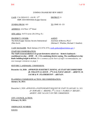
ZONING CHANGE REVIEW SHEET HLC DATE: PC DATE: November 16, 2020 December 14, 2020 January 26, 2021 CASE NUMBER: C14H-2021-0006 (Formerly HDP-2020-0440) APPLICANT: Historic Landmark Commission HISTORIC NAME: Delta Kappa Gamma Building WATERSHED: Shoal Creek ADDRESS OF PROPOSED ZONING CHANGE: 416 W. 12th Street Council District: 9 ZONING FROM: GO to DMU-H-CO SUMMARY STAFF RECOMMENDATION: Staff recommends the proposed zoning change from general office (GO) district to downtown mixed use – Historic Landmark (DMU-H) combining district zoning. While staff appreciates the property owners’ dilemma in what they now view as a financial and maintenance burden, the building has demonstrated significance as reflected by its individual inclusion on the National Register of Historic Places. National Register designation in and of itself does not prevent modification or even demolition of the building, but in the City of Austin, National Register designation does automatically qualify a building as eligible for landmark designation, which does place a barrier on demolition. Staff cannot recommend that a building individually listed on the National Register of Historic Places should be demolished, and must recommend landmark designation for the building to determine if the Commission or the Planning Commission, and ultimately the City Council votes to grant the building historic zoning. Given the architecture and history of this building, staff would recommend landmark designation even if the building were not listed on the National Register. In the meantime, staff recommends that the applicant for the demolition permit continue to develop proposals to incorporate the building into new development plans for the site, which staff acknowledges may preclude the construction of a high-rise building on this site. In staff’s evaluation, preserving portions of the exterior finishes of the building into an interior space of the proposed new building is not sufficiently respectful of the integrity, design, and significance of the existing building. Continuing conversations about the relationship of historic and new may result in a proposal that is much more palatable to both the owners of the building and the interests of preserving buildings that have demonstrated historical significance. QUALIFICATIONS FOR LANDMARK DESIGNATION: The building is listed on the National Register of Historic Places. HISTORIC LANDMARK COMMISSION ACTION: November 16, 2020: Initiated historic zoning. Vote: 9-0-2 (Papavasiliou and Jacob off-dais). December 14, 2020: Recommended historic zoning (Tollett/Koch). Vote: 9-0-1 (Papavasiliou absent; Featherston abstaining). PLANNING COMMISSION ACTION: 1 of 32B-7 DEPARTMENT COMMENTS: The building was listed on the National Register …
Planning Commission: January 26, 2021 NEIGHBORHOOD PLAN AMENDMENT REVIEW SHEET NEIGHORHOOD PLAN: East MLK Combined Neighborhood Plan CASE#: NPA-2020-0015.04 .SH DATE FILED: July 30, 2020 (In-cycle) PROJECT NAME: Lott Avenue PC DATE: January 26, 2021 ADDRESS/ES: 4908 Lott Ave; 5000-5016 Lightfield Ln; 1160-1166 Mason Ave DISTRICT AREA: 1 SITE AREA: 5.01 acres OWNER/APPLICANT: 4908 Lott Holdings, LLC (GMJ Real Estate Investments, LLC) (Matt McDonnell) (Note: Agent at time application was filed on July 30, 2020 – David Suissa) AGENT: Armbrust & Brown, PLLC (Michael J. Whellan) (Note: Agent at time application was filed on July 30, 2020 – David Suissa) CASE MANAGER: Jeffrey Engstrom, Senior Planner, Housing & Planning Department PHONE: (512) 974-1621 STAFF EMAIL: Jeffrey.engstrom@austintexas.gov TYPE OF AMENDMENT: Change in Future Land Use Designation To: Higher Density Single Family From: Single Family Base District Zoning Change Related Zoning Case: C14-2020-0135.SH From: SF-3-NP To: SF-6-NP NEIGHBORHOOD PLAN ADOPTION DATE: November 7, 2002 PLANNING COMMISSION RECOMMENDATION: 1 1 of 38B-8 Planning Commission: January 26, 2021 January 26, 2021 - STAFF RECOMMENDATION: To grant applicant’s request for Higher Density Single Family BASIS FOR STAFF’S RECOMMENDATION: Staff recommends the FLUM change request from Single Family land use to Higher Density Single Family land use. Staff recommends the project because it would be compatible with residential housing adjacency; provide owner occupied infill housing; and is supported by housing policies and text found in the Imagine Austin Comprehensive Plan, the East MLK Combined Neighborhood Plan, and the Austin Strategic Housing Blueprint. Below are excerpts from the East MLK Combined Neighborhood Plan that supports infill housing and small-lot single family housing in this portion of the planning area. Goal 1: Preserve established residential areas and improve opportunities for home ownership by promoting the rehabilitation of existing housing and new, infill housing compatible with the existing style of this neighborhood. (pg. 44). Objective 1.2: Promote new infill housing in appropriate locations. Goal 5: Provide housing that helps to maintain the social and economic diversity of residents. (pg. 45) Below are additional policies and text that are excerpted from the East MLK Combined Neighborhood Plan that supports a change from Single Family to High Density Single Family on the Future Land Use Map: Fort Branch Recommendations: The greatest need in the Fort Branch area is continued development of quality residential infill. Some larger tracts on Webberville, Tannehill Lane, and Jackie Robinson Street could be developed with mixed residential, …
ZONING CHANGE REVIEW SHEET DISTRICT: 3 TO: SF-6-CO-NP CASE: C14-2020-0135.SH ZONING FROM: SF-3-NP ADDRESS: 4908 Lott Avenue, 5000-5106 Lightfield Lane, & 1160-1166 Mason Avenue SITE AREA: 5.01 acres PROPERTY OWNER: 4908 Lott Holdings, LLC (Matt McDonnell) CASE MANAGER: Heather Chaffin (512-974-2122, heather.chaffin@austintexas.gov) STAFF RECOMMENDATION: Staff supports the Applicant’s request for rezoning to townhouse/condominium residential-conditional overlay-neighborhood plan (SF-6-CO-NP) combining district zoning. The conditional overlay will limit impervious cover to 51% exclusive of any shared-use path that allows public access to Springdale Neighborhood Park. AGENT: Armbrust & Brown, PLLC (Michael Whellan) For a summary of the basis of staff’s recommendation, see case manager comments on page 2. PLANNING COMMISSION ACTION / RECOMMENDATION: January 26, 2021: CITY COUNCIL ACTION: February 18, 2021: ORDINANCE NUMBER: 1 of 24B-9 C14-2020-0135.SH 2 ISSUES The proposed rezoning is for a 5.01 acre tract that was platted for 31 single family and duplex residential units in 2019. Please see Exhibit C- Approved Plat. The property changed hands in September 2020; the new owner is proposing 55 townhouse/condominium residential units. The applicant has provided a SMART Housing letter stating that 5 ownership units will be included at 80% of Median Family Income (MFI) for 99 years. Please see Exhibit D- SMART Housing Letter. CASE MANAGER COMMENTS: The rezoning tract is located northeast of the intersection of Lott Avenue and Mason Avenue in the MLK-183 area of the East MLK Combined Neighborhood Planning Area (NPA). The property is undeveloped and zoned SF-3-NP. Immediately north of the property is Springdale Neighborhood Park, which is zoned P-NP. The eastern boundary is Fort Branch Creek, and properties to the east are zoned SF-3-NP. While some of these properties are undeveloped because of their location in the floodplain, others in the area are developed with single family residences. Further to the east, on Delano Street and Jackie Robinson Street are properties zoned SF-6-NP and SF-6-CO-NP. South and southwest of the rezoning tract is a single family neighborhood zoned SF-3-NP. A single SF-6-NP tract is located in the vicinity and appears to be developed with a single family residence. To the west and northwest of the rezoning tract are single family residences zoned SF-3-NP. Further west, along Webberville Road, is a mix of SF-3-NP and GR-MU-NP zoned properties, including single family and multifamily properties, as well as a fire station. Please see Exhibits A and B- Zoning Map and Aerial Exhibit. As stated previously, the …
C14-2020-0130 1 ZONING CHANGE REVIEW SHEET CASE: C14-2020-0130 – 5613 Patton Ranch Road DISTRICT: 8 ZONING FROM: MF-1-NP TO: MF-4-NP ADDRESS: 5613 Patton Ranch Road SITE AREA: 14.8 acres PROPERTY OWNER: St. Andrew's Episcopal School (Jason Near) AGENT: McLean & Howard (Jeff Howard) CASE MANAGER: Kate Clark (512-974-1237, kate.clark@austintexas.gov) STAFF RECOMMENDATION: Staff recommends multifamily residence (moderate-high density) – neighborhood plan (MF-4-NP) combining district zoning. For a summary of the basis of staff’s recommendation, see page 2. PLANNING COMMISSION ACTION / RECOMMENDATION: January 26, 2021 Scheduled for Planning Commission CITY COUNCIL ACTION: Not scheduled for City Council at this time. ORDINANCE NUMBER: ISSUES This site is partially located over the Edwards Aquifer Recharge Zone within the Barton Creek Watershed. Project applications at the time of this report are subject to the SOS ordinance that allows 15% impervious cover in the Recharge Zone portion of the property and 20% impervious cover in remainder of property, (see Environmental comments). The City of Austin’s Watershed Department has an active project within this area called the Oak Park Flood Risk Reduction Project. The purpose of this project is to reduce the amount of flooding in the area and is currently in the design phase. The project is expected to go to construction in the Summer of 2022. This project is not related to the rezoning request and is not located within the boundaries of the requested rezoning area. It is however located on land owned by the applicant of this rezoning case, St. Andrew’s Episcopal School. 1 of 20B-10 C14-2020-0130 2 CASE MANAGER COMMENTS: The area being requested to be rezoned is approximately 14.8 acres and is located on the east side of both Patton Ranch and Vega Avenue. It is part of a larger lot that is currently zoned MF- 1-NP. The applicant is asking to rezone a portion of their lot to MF-4-NP, the remaining area would stay MF-1-NP. Adjacent to the north of the MF-1-NP lot is a property zoned GR-CO-NP and contains the St. Andrew's Episcopal School and to the east are properties zoned SF-2-NP with single-family residences. Across School Road to the south is a property zoned P-NP which contains the Oak Hill Elementary School. To the west across Patton Ranch Road are properties zoned RR-NP containing a single-family residence and LR-NP containing an administrative and business offices. Also, to the west across Vega Avenue are properties zoned MF-2-NP containing …
C14-2020-0102 1 ZONING CHANGE REVIEW SHEET CASE: C14-2020-0102 – Thomas Springs DISTRICT: 8 Office/Warehouse ZONING FROM: RR-NP ADDRESS: 7815 Thomas Springs Road SITE AREA: 6.49 acres TO: W/LO-NP (Tract 1), as amended SF-3-NP (Tract 2), as amended PROPERTY OWNER: Loco Grande Enterprises LLC (Brandon Brydson) AGENT: Alice Glasco Consulting (Alice Glasco) CASE MANAGER: Kate Clark (512-974-1237, kate.clark@austintexas.gov) STAFF RECOMMENDATION: Staff recommends warehouse/limited office – neighborhood plan (W/LO-NP) combining district zoning for Tract 1 and family residence – neighborhood plan (SF-3-NP) combining district zoning for Tract 2. For a summary of the basis of staff’s recommendation, see page 2. PLANNING COMMISSION ACTION / RECOMMENDATION: January 26, 2021 Scheduled for Planning Commission CITY COUNCIL ACTION: February 18, 2021 Scheduled for City Council ORDINANCE NUMBER: ISSUES Staff has received comments in opposition to the rezoning of this property. Only written or emailed comments are included in staff backup and may be found in Exhibit C: Correspondence Received. On December 14, 2020 staff received a petition against the rezoning request. The current percentage of the petition is 49.39%. The petition, a map and list of property owners of the petition area and the signatures received to date are included in Exhibit D: Formal Petition. On December 28, 2020 the applicant amended their rezoning request. Originally, they were requesting the entire property be rezoned to W/LO-NP. Their amended request divided their 1 of 20B-11 C14-2020-0102 2 property into two tracts, requesting Tract 1 to be rezoned to W/LO-NP and Tract 2 to be rezoned to SF-3-NP, please see Exhibit E: Amended Rezoning Request. CASE MANAGER COMMENTS: This property is approximately 6.49 acres and has access to Thomas Springs Road and Wier Loop Road. It is currently zoned RR-NP and is surrounded by properties zoned RR-NP to the northeast, east and south. Adjacent to the southwest is a property zoned LO-NP. Across Thomas Springs Road to the north are properties not within the City limits and therefore are not zoned. Please refer to Exhibit A: Zoning Map and Exhibit B: Aerial Map. This property is currently shown as Rural Residential on the Future Land Use Map (FLUM) and requires a Neighborhood Plan Amendment (NPA) with this rezoning case. Please see related case NPA-2020-0025.01. This property is located within the Williamson Creek Watershed which is classified as a Barton Springs Zone Watershed. At the time of this report it is subject to the SOS ordinance which would …
C14-2020-0102 1 ZONING CHANGE REVIEW SHEET CASE: C14-2020-0102 – Thomas Springs DISTRICT: 8 Office/Warehouse ZONING FROM: RR-NP ADDRESS: 7815 Thomas Springs Road SITE AREA: 6.49 acres TO: W/LO-NP (Tract 1), as amended SF-3-NP (Tract 2), as amended PROPERTY OWNER: Loco Grande Enterprises LLC (Brandon Brydson) AGENT: Alice Glasco Consulting (Alice Glasco) CASE MANAGER: Kate Clark (512-974-1237, kate.clark@austintexas.gov) STAFF RECOMMENDATION: Staff recommends warehouse/limited office – neighborhood plan (W/LO-NP) combining district zoning for Tract 1 and family residence – neighborhood plan (SF-3-NP) combining district zoning for Tract 2. For a summary of the basis of staff’s recommendation, see page 2. PLANNING COMMISSION ACTION / RECOMMENDATION: January 26, 2021 Scheduled for Planning Commission CITY COUNCIL ACTION: February 18, 2021 Scheduled for City Council ORDINANCE NUMBER: ISSUES Staff has received comments in opposition to the rezoning of this property. Only written or emailed comments are included in staff backup and may be found in Exhibit C: Correspondence Received. On December 14, 2020 staff received a petition against the rezoning request. The current percentage of the petition is 49.39%. The petition, a map and list of property owners of the petition area and the signatures received to date are included in Exhibit D: Formal Petition. On December 28, 2020 the applicant amended their rezoning request. Originally, they were requesting the entire property be rezoned to W/LO-NP. Their amended request divided their 1 of 20B-12 C14-2020-0102 2 property into two tracts, requesting Tract 1 to be rezoned to W/LO-NP and Tract 2 to be rezoned to SF-3-NP, please see Exhibit E: Amended Rezoning Request. CASE MANAGER COMMENTS: This property is approximately 6.49 acres and has access to Thomas Springs Road and Wier Loop Road. It is currently zoned RR-NP and is surrounded by properties zoned RR-NP to the northeast, east and south. Adjacent to the southwest is a property zoned LO-NP. Across Thomas Springs Road to the north are properties not within the City limits and therefore are not zoned. Please refer to Exhibit A: Zoning Map and Exhibit B: Aerial Map. This property is currently shown as Rural Residential on the Future Land Use Map (FLUM) and requires a Neighborhood Plan Amendment (NPA) with this rezoning case. Please see related case NPA-2020-0025.01. This property is located within the Williamson Creek Watershed which is classified as a Barton Springs Zone Watershed. At the time of this report it is subject to the SOS ordinance which would …
DOWNTOWN DENSITY BONUS PROGRAM (DDBP) SUBMITTAL APPLICATION INSTRUCTIONS A property owner (Owner) or his/her representative (Applicant) acting on behalf of the Owner can initiate an administrative request to the Director of Planning (Director) seeking additional Floor-to-Area (FAR) entitlements as outlined in the Downtown Density Bonus Program as approved by Ordinance No. 20140227-054. In order for the Director to conduct an administrative review, the requirements listed below must be submitted. Once an application is deemed complete, the Director will inform the Applicant of review commencement. The following submittals are required in a complete PDF package of no more than 10 Mb in size with sheets no larger than 11x17 inches: 1. Completed DDBP Application; 2. Vicinity plan locating the project in its context, and showing a minimum 9 block area around the project; 3. Location and nature of nearby transit facilities; 4. Drawings (submitted drawings should demonstrate compliance with Subchapter E Design Standards, as applicable): o Site plan; o Floor plans; o Exterior elevations (all sides); o Three-dimensional views; 5. As part of the gatekeeper requirements, o Urban Design Guidelines checklist; o Great Streets - ; o 2 Star Austin Energy Green Building rating - submit copy of the projects signed Austin Energy Green Building Letter of Intent and Austin Energy Green Building checklist.; 6. Other items that may be submitted but not required: Narrative / graphics / photos to further describe the project. 7. Coordination memo acknowledgment from the City of Austin’s Neighborhood Housing and Community Development Department (NHCD) detailing affordable housing community benefits. Please contact Ms. Sandra Harkins at NHCD for more information. 1 of 36B-13 DOWNTOWN DENSITY BONUS PROGRAM (DDBP) SUBMITTAL APPLICATION 1. Project Name: 2. Property Owner Name: Address: Phone: E-mail: Name: Address: Phone: E-mail: 3. Applicant/Authorized Agent 4. Anticipated Project Address: Page 1 of 9 2 of 36B-13 5. Site Information a. Lot area (also include on site plan): b. Existing zoning (include any zoning suffixes such as “H,” “CO,” etc. If the property has a conditional overlay (CO), provide explanation of conditions (attach additional pages as necessary): c. Existing entitlements: I. Current floor to area (FAR) limitation: II. Current height limitation (in feet) : III. Affected by Capitol View Corridors (CVCs) Yes/No? Yes No If yes, please provide specify height allowed under CVC: 6. Existing Deed Restrictions Detail existing deed restrictions on the property (if any): Page 2 of 9 3 of 36B-13 7. Building …
SUBDIVISION REVIEW SHEET CASE NO.: C8J-2020-0013 SUBDIVISION NAME: West Bella Fortuna Preliminary Plan AREA: 93.28 acres OWNER/APPLICANT: Clayton Properties Group, Inc. Brohn Homes (Tyler LOT(S): 344 PC DATE: 1/26/21 Gatewood) AGENT: Doucet & Associates (Davood Salek) ADDRESS OF SUBDIVISION: Approx. 13300 Bradshaw Rd GRIDS: G-10 WATERSHED: Onion Creek and Rinard Creek COUNTY: Travis JURISDICTION: 2-Mile ETJ MUD: N/A EXISTING ZONING: N/A PROPOSED LAND USE: Single Family, Drainage, Landscape, Park ADMINISTRATIVE WAIVERS: N/A VARIANCES: None SIDEWALKS: Sidewalks will be provided on all internal streets. DEPARTMENT COMMENTS: The request is for approval with conditions of the West Bella Fortuna Preliminary Plan consisting of 344 lots on 93.28 acres. Water and wastewater will be provided by the City of Austin. STAFF RECOMMENDATION: The staff recommends approval with conditions of this preliminary plan. This plan will be back to Commission when it meets all applicable County, State and City of Austin LDC requirements. ZONING AND PLATTING COMMISSION ACTION: CASE MANAGER: Sarah Sumner Email address: sarah.sumner@traviscountytx.gov PHONE: 512-854-7687 1 1 of 5B-14 i i g n p p a M / g n y e v r u S - s t n e m e l t i t n E - g n i r i e e n g n E l i i v C 0 6 1 e t i u S , W 1 7 y a w h g H i . B 1 0 4 7 0 0 6 2 - 3 8 5 - ) 2 1 5 ( : e n o h P , 5 3 7 8 7 s a x e T , n i t s u A m o c . s r i t e e n g n e e c u o d w w w . 7 3 9 3 : r e b m u N n o i t a r t s i g e R m r i F PHASE 2 IS NOT PART OF THIS PRELIMINARY PLAN AND IS ALREADY PLATTED WITH BELLA FORTUNA SUBDIVISION PRELIMINARY PLAN CASE# C8J-2017-0235 · · 12/18/202 of 5B-14 i i g n p p a M / g n y e v r u S - s t n e m e l t i t n E - g n i r i e e n g n E l i i v C …
ZONING CHANGE REVIEW SHEET CASE: C14-2020-0112 - 416 W. 12th HDP-2020-0440 Delta Kappa Gamma DISTRICT: 9 ZONING FROM: GO TO: DMU-H -CO ADDRESS: 416 West 12th Street SITE AREA: 0.6733 acres (29,330 sq. ft.) PROPERTY OWNER: The Delta Kappa Gamma Society International (Nita Scott) AGENT: Armbrust & Brown, PLLC (Michael J. Whellan, Michael J. Gaudini) CASE MANAGER: Mark Graham (512-974-3574, mark.graham@austintexas.gov ) STAFF RECOMMENDATION: The Staff recommendation is to grant downtown mixed use – historic landmark - conditional overlay – (DMU – H - CO) combining district zoning. The conditional overlay limits building height to 60 feet. For a summary of the basis of staff’s recommendation, see case manager comments on page 2. HISTORIC LANDMARK COMMISSION: December 14, 2020: APPROVED H DISTRICT ZONING, AS STAFF RECOMMENDED [B. TOLLETT, K. KOCH – 2ND] (8-0) PAPAVASILOU – ABSENT; M. JACOB & W. FEATHERSTON – ABSTAIN. PLANNING COMMISSION ACTION / RECOMMENDATION: January 26, 2021: December 8, 2020: APPROVED A POSTPONEMENT REQUEST BY STAFF TO JANUARY 26, 2021. [P. HOWARD, C. HEMPEL 2ND] (10-0) Y. FLORES; P. SEEGER – ABSENT; ONE VACANCY ON THE COMMISSION. CITY COUNCIL ACTION: February 18, 2021: ORDINANCE NUMBER: ISSUES B-61 of 19 C14-2020-0112 2 Applicant requested DMU district zoning that allows for a maximum of 120-foot building height. Applicant also indicated that they would seek a Downtown Density Bonus to achieve additional building height. The building designs presented to the Historic Landmark Commission in October 2020 were almost 360 feet tall. The staff recommendation of DMU-H-CO with the Conditional Overlay limiting building height to 60 feet would not permit the proposed building. If the Staff recommendation is approved by Council, a subsequent rezoning application to DMU without a Conditional Overlay would be required to obtain and use the Downtown Density Bonus Program for bonus height and Floor to Area Ratio (FAR) to achieve the entitlement to build over 60 feet. At their November 16, 2020 meeting, the Historic Landmark Commission (HLC) requested that City staff prepare a Historic zoning application for the Delta Kappa Gamma Building. On December 14, 2020, HLC recommended historic (H) district zoning be added to the zoning string of the property. A historic zoning case was filed on January 13, 2021 and is being processed concurrently (C14H-2021-0006). Previous Historic Designations The Delta Kappa Gamma (DKG) International Headquarters Building, built in 1956, is a City of Austin Landmark, designated a Recorded Texas Historic Landmark and listed …
Meeting of the Planning Commission January 26, 2021 Planning Commission to be held January 26, 2021 with Social Distancing Modifications Public comment will be allowed via telephone; no in-person input will be allowed. All speakers, including applicants and representatives, must register in advance (Day before the scheduled meeting, January 25, 2021 by noon). To speak remotely at the January 26, 2021 Planning Commission Meeting, residents must: Preferably email the board liaison at andrew.rivera@austintexas.gov or call 512-974-6508 the day before the meeting. The following information is required: 1. The speaker name. 2. Item number(s) they wish to speak on. 3. Whether they are for/against/neutral. 4. Mailing address. 5. Telephone number. Must be the number that will be used to call-in. Failure to provide the required information by noon January 25, 2021 shall render a request null and void. A registered speaker may not sign up another speaker. Previous registration on an item does not automatically roll over. •Once a request to register to speak has been called in or emailed to the board liaison, residents will receive either an email or phone call with additional information regarding the call in process. •Handouts or other information must be emailed to andrew.rivera@austintexas.gov by 1:00 PM Tuesday, January 26, 2021 This information will be provided to Commission members in advance of the meeting. •Residents may watch the meeting here: http://www.austintexas.gov/page/watch-atxn-live Postponement requests must be submitted to the case manager and Andrew Rivera by 5PM Monday, January 25, 2021 Reunión de la Comisión de Planificación Fecha 26 de enero de 2021 La Comisión de Planificación se reunirá el 26 de enero de 2021 con modificaciones de distanciamiento social. Se permitirán comentarios públicos por teléfono; no se permitirá ninguna entrada en persona. Llame o envíe un correo electrónico al enlace de la junta en 512-974-6508 andrew.rivera@austintexas.gov a más tardar al mediodía (el día antes de la reunion, 25 de enero de 2021). 1. El nombre del orador. 2. Número (s) de artículo sobre el que desean hablar. 3. Si están a favor / en contra / neutrales. 4. Dirección postal. 5. Número de teléfono. Debe ser el número que se utilizará para llamar a la persona que desea hablar. Si la información solicitada no se envía antes del mediodía del 25 de enero de 2021, la solicitud será nula y sin efecto. Un orador registrado no puede registrar a otro orador. El registro anterior de un …