Agenda — original pdf
Agenda
Agenda
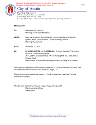
City of Austin Planning Department 6310 Wilhelmina Delco Drive, Austin, TX 78752 P.O. Box 1088, Austin, TX 78767 -1088 (512) 974-2000 ♦ h ttp s:/ / w w w.a u st in tex a s .g ov / d epa r tm e n t/ plan n in g - de part men t MEMORANDUM TO: FROM: Claire Hempel, Chair & Planning Commission Members Maureen Meredith, Senior Planner, Long-Range Planning Division Cynthia Hadri, Senior Planner, Current Planning Division Planning Department DATE: December 11, 2024 RE: NPA-2023-0027.01 and C14-2024-0051_Rawson Saunders/Tarrytown Christian Church Improvement 2614, 2614 ½ Exposition Blvd, 2702 McCullough St, 2611 and 2615 ½ Hillview Road Central West Austin Combined Neighborhood Planning Area (WANG) The Applicant requests an indefinite postponement of the above-referenced cases. See attached letter from Victoria Haase, Thrower Design, LLP. The postponement request was made in a timely manner and meets the Planning Commission’s policy. Attachments: Letter from Victoria Haase, Thrower Design, LLP Plan Amendment Map Zoning Map The City of Austin is committed to compliance with the Americans with Disabilities Act and will provide reasonable modifications and equal access to communications upon request. 02 and 03 NPA-2024-0027.01 and C14-2024-0051 Rawson Saunders - Tarrytown Christian Church Improvements; District 101 of 4 The City of Austin is committed to compliance with the Americans with Disabilities Act and will provide reasonable modifications and equal access to communications upon request. 02 and 03 NPA-2024-0027.01 and C14-2024-0051 Rawson Saunders - Tarrytown Christian Church Improvements; District 102 of 4 The City of Austin is committed to compliance with the Americans with Disabilities Act and will provide reasonable modifications and equal access to communications upon request. 02 and 03 NPA-2024-0027.01 and C14-2024-0051 Rawson Saunders - Tarrytown Christian Church Improvements; District 103 of 4 The City of Austin is committed to compliance with the Americans with Disabilities Act and will provide reasonable modifications and equal access to communications upon request. 02 and 03 NPA-2024-0027.01 and C14-2024-0051 Rawson Saunders - Tarrytown Christian Church Improvements; District 104 of 4
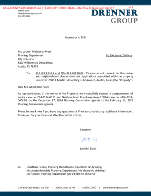
Leah M. Bojo lbojo@drennergroup.com 512-807-2918 Ms. Lauren Middleton-Pratt Planning Department City of Austin 6310 Wilhelmina Delco Drive Austin, TX 78752 Dear Ms. Middleton-Pratt: December 4, 2024 Via Electronic Delivery Re: C14-2024-0111 and NPA-2024-0008.01 - Postponement request for the zoning and neighborhood plan amendment applications associated with the property located at 2600 E Martin Luther King Jr Boulevard, Austin, Texas (the “Property”). As representatives of the owner of the Property, we respectfully request a postponement of zoning case no. C14-2024-0111 and Neighborhood Plan Amendment (NPA) case no. NPA-2024- 0008.01 on the December 17, 2024 Planning Commission agenda to the February 11, 2025 Planning Commission agenda. Please let me know if you have any questions or if we can provide any additional information. Thank you for your time and attention to this matter. Sincerely, Leah M. Bojo cc: Jonathan Tomko, Planning Department (via electronic delivery) Maureen Meredith, Planning Department (via electronic delivery) Joi Harden, Planning Department (via electronic delivery) 2705 Bee Cave Road, Suite 100 | Austin, Texas 78746 | 512-807-2900 | www.drennergroup.com 04 and 05 NPA-2024-0008.01 and C14-2024 0111 2600 E Martin Luther King Jr. Boulevard; District 11 of 1
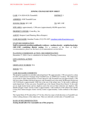
ZONING CHANGE REVIEW SHEET CASE: C14-2024-0128 (Tannehill) DISTRICT: 1 ADDRESS: 4108 Tannehill Lane ZONING FROM: SF-3-NP TO: MF-3-NP SITE AREA: approximately 1.398 acres (approximately 60,896 square feet) PROPERTY OWNER: Coma Rey, Inc. AGENT: Keepers Land Planning (Ricca Keepers) CASE MANAGER: Jonathan Tomko (512) 974-1057, jonathan.tomko@austintexas.gov STAFF RECOMMEDATION: Staff recommends granting multifamily residence – medium density – neighborhood plan the basis of Staff’s (MF-3-NP) combining district zoning. For a summary of recommendation, please see the basis of recommendation section below. PLANNING COMMISSION ACTION / RECOMMENDATION: December 17, 2024: Case is scheduled to be heard by Planning Commission. CITY COUNCIL ACTION: TBD ORDINANCE NUMBER: N/A ISSUES: N/A CASE MANAGER COMMENTS: The property in question is currently undeveloped land. The approximately 1.398-acre parcel is a deep lot with a small amount of frontage along Tannehill Lane, an ASMP level 2 roadway. The subject tract is just north of where Samuel Huston Avenue intersects with Tannehill Lane and approximately 1,500 feet from where Webberville Road intersects with Tannehill Lane to the north. Ed Bluestein Boulevard (183 Toll Road) is approximately 2,000 feet to the east of the subject tract. To the north is additional undeveloped land. To the east across Tannehill Lane is the Greater Mount Zion Church. To the south are six single-family homes and two duplexes and to the west are three relatively new duplexes. The Mueller Imagine Austin Activity Center is approximately 1 mile northwest of the subject tract and the Colony Park Station Imagine Austin Activity Center is approximately 2 miles northeast of the subject tract. The Capital Metro #5 Woodrow/East 12th St. Bus offers bus stops in both directions on Tannehill Lane within walking distance of the subject tract. There are sidewalks on both sides of Tannehill Lane. BASIS OF RECOMMENDATION: Zoning should allow for reasonable use of the property. 06 C14-2024-0128 - Tannehill; District 11 of 14 C14-2024-0128 2 The subject tract is currently undeveloped. It is situated across from a large parking lot that serves the Greater Mount Zion Church. There are sidewalks and a bus stop, and the site is across the street from a substantial amount of more intense zoning that fronts Ed Bluestein Boulevard (183 Toll Road). This rezoning would allow for a reasonable use of the property and this rezoning does not require an NPA or a Future Land Use Map change as the property is already identified as Mixed Residential. Zoning should …
ZONING CHANGE REVIEW SHEET CASE: C14-2024-0140– 1916 Fort View Rezone DISTRICT: 5 TO: CS-1 ADDRESS: 1916 Fort View Road ZONING FROM: CS SITE AREA: 0.033 acres PROPERTY OWNER: Walima, LLC (Abdul Patel) AGENT: Land Answers, INC (Tamara Mitchell) CASE MANAGER: Marcelle Boudreaux (512-974-8094, marcelle.boudreaux@austintexas.gov) STAFF RECOMMENDATION: The Staff recommendation is to grant commercial – liquor sales – conditional overlay (CS-1-CO) district zoning. The Conditional Overlay would prohibit these uses permitted in CS-1 base zoning: Adult-Oriented Business and Adult Lounge use. PLANNING COMMISSION ACTION / RECOMMENDATION: December 17, 2024: CITY COUNCIL: ORDINANCE NUMBER: ISSUES: None at this time. CASE MANAGER COMMENTS: The subject rezoning area is approximately 1,452 square feet (or .033 acres) and is developed with a single-story commercial space that is currently vacant. The rezoning area is situated at the northeast corner of Fort View Road and Menchaca Road, approximately 350 feet north of Ben White Boulevard. The site is located within the Lamar & Ben White Activity Center, as identified on the Growth Concept Map in the Image Austin Comprehensive Plan. Development around the immediate intersection of Fort View Road and Menchaca Road is 07 C14-2024-0140 - 1916 Fort View Rezone; District 51 of 11 C14-2024-0140 Page 2 generally characterized by diverse commercial uses highlighting access to Ben White Boulevard, including restaurants, limited restaurants many with drive-through use, automotive repair services, and personal improvement services uses (CS; CS-1; GR-MU; LR-MU-CO; GR; LO; LO-MU). Extending north and south along Menchaca Road and east along Fort View Road are more office and commercial uses with some townhomes and multifamily residential (LO; LO-CO; LR-CO; CS; GR). Extending further west along Fort View Road, the commercial zoning transitions to single family residences (SF-3). Please refer to Exhibits A (Zoning Map), A-1 (Aerial View). The Applicant proposes to rezone the property to commercial – liquor sales (CS-1) district for a 1,452-square-foot liquor store at an existing single-story commercial space that is currently vacant. A cocktail lounge is also a permitted use under the CS-1 zoning district, however requires a Conditional Use Permit to be reviewed by the Planning Commission prior to establishing use. BASIS OF RECOMMENDATION: The proposed zoning should be consistent with the purpose statement of the district sought. The Commercial – Liquor Sales (CS-1) is intended predominately for commercial and industrial activities of a service nature which typically have operating characteristics or traffic service requirements generally incompatible with residential environments, and …
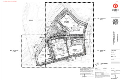
PLANNING COMMISSION SITE PLAN CONDITIONAL USE PERMIT REVIEW SHEET CASE NUMBER: SP-2022-0255C.F2(R1) PLANNING COMMISSION DATE: Dec 17, 2024 PROJECT NAME: River Park South Block D PROPOSED USE: Cocktail lounge ADDRESS OF APPLICATION: 4800 E Riverside Dr COUNCIL DISTRICT: 3 AREA: 63,705 gross square feet APPLICANT: AGENT: Alexandra Boone, P.E. GarzaEMC, LLC Austin, TX Michael Whellan Armbrust & Brown, PLLC Austin, TX CASE MANAGER: Christine Barton-Holmes, CNUa, LEED AP Telephone: 974-2788 christine.barton-holmes@austintexas.gov EXISTING ZONING: The site is within the Corridor Mixed Use subdistrict of the East Riverside Regulating Plan. This site is part of a larger overall project with frontages on East Riverside, Wickersham Ln, and Crossing Place. This site fronts onto East Riverside, which is a Core Transit Corridor. The entire site has an approved site plan, SP-2022-0255C.F1 and F2, which is proposed to be modified with this application. PROPOSED DEVELOPMENT: The overall project is proposed to be a mix of uses, predominantly multifamily/mixed use. River Park South Block D has been proposed to be developed as an indoor entertainment venue with a cocktail lounge. Indoor entertainment is a permitted use in the subdistrict; the cocktail lounge requires approval of a Conditional Use Permit. The revision as designed complies with all requirements of the East Riverside Regulating Plan. SUMMARY STAFF RECOMMENDATION: Staff recommends approval of the Conditional Use Permit to construct the indoor entertainment venue with cocktail lounge uses. PREVIOUS PLANNING COMMISSION ACTION: NA AREA STUDY: Pleasant Valley Neighborhood Planning Area WATERSHED: Country Club West (Suburban watershed) APPLICABLE WATERSHED ORDINANCE: Current/ Comprehensive watershed ordinance CAPITOL VIEW: NA 08 SP-2022--255C.F2(R1) - River Park South Block D; District 31 of 16 IC:54% PROPOSED FAR: 1:01 PROPOSED BLDG. CVRG: 38% (site PROPOSED T.I.A.: Not Required PROJECT INFORMATION 2.31 acre site; part of 15.28-acre site overall EXIST. ZONING: ERC-CMU ALLOWED F.A.R.: 1.65:1 MAX. BLDG. COVERAGE: 80% MAX. IMPERVIOUS CVRG.: 90% REQUIRED PARKING: 0 VEHICLES/0 BIKES PROVIDED PKNG: 339 VEHICLES/31 BIKES SUMMARY COMMENTS ON SITE PLAN: Land Use: The applicant is requesting a Conditional Use Permit to allow the construction of a 63,705 square foot cocktail lounge as part of an indoor entertainment facility. A cocktail lounge is a conditional use in the Corridor Mixed Use subdistrict of the East Riverside Corridor Regulating Plan. The site plan will comply with all requirements of the Land Development Code prior to its release. Environmental: The site is in the Country Club West Suburban watershed. There are no …
) . E N A L M A H S R E K C I W W . O . R C I L B U P H T D I W E L B A I R A V ( 466 4 6 7 7 6 4 8 6 4 9 6 4 8 6 4 7 6 4 470 471 472 4 7 0 0 2 . 6 9 2 . 6 7 8 7 8 7 1 . 0 7 8 4 7 3 4 7 4 0 7 4 0 0 0 1 . 1 1 . 6 2 . 1 7 7 7 8 8 8 471 472 8 0 7 2 . 6 4 6 9 471 473 470 472 S E 6 P H A S E 6 P H A S E 2 474 4 7 2 4 7 3 1 . 2 1 . 3 2 . 7 1 . 3 1 . 3 1 . 5 9 7 8 0 7 8 8 7 8 8 7 7 5 8 6 7 8 7 A H 8 6 4 7 6 4 P 8 6 4 0 7 4 9 6 4 0 7 4 1 7 4 7 1 . 5 7 8 1 7 4 2 7 4 4 2 . 2 7 8 0 2 . 6 7 8 2 2 . 7 7 8 473 469 470 4 7 0 0 7 4 1 7 4 9 6 4 470 4 6 9 4 7 2 0 7 4 1 7 4 3 2 . 1 7 8 AF 9 6 4 AF B B B 470 6 2 . 7 7 8 4 7 3 4 7 3 4 2 . 6 7 8 3 7 4 HERITAGE TREE TO BE RELOCATED CONCRETE TRAIL BROOM FINISH SWING BENCH TRANSFORMER LOCATION 2 7 4 1 7 4 # 1 0 0 2 2 4 . 5 " L O 5 2 . 2 7 4 + t w B AF 469 2 7 4 US US AF 0 7 4 4 7 1 B B B 0 7 4 B US AF A A A AF US US B US US B US A A A 5 0 . 2 7 4 + B A A A B B 0 . 0 7 4 + US …
09 2024-128390 LM - 1114 West 5th Street; District 91 of 13 09 2024-128390 LM - 1114 West 5th Street; District 92 of 13 09 2024-128390 LM - 1114 West 5th Street; District 93 of 13 09 2024-128390 LM - 1114 West 5th Street; District 94 of 13 09 2024-128390 LM - 1114 West 5th Street; District 95 of 13 09 2024-128390 LM - 1114 West 5th Street; District 96 of 13 09 2024-128390 LM - 1114 West 5th Street; District 97 of 13 09 2024-128390 LM - 1114 West 5th Street; District 98 of 13 09 2024-128390 LM - 1114 West 5th Street; District 99 of 13 09 2024-128390 LM - 1114 West 5th Street; District 910 of 13 09 2024-128390 LM - 1114 West 5th Street; District 911 of 13 09 2024-128390 LM - 1114 West 5th Street; District 912 of 13 09 2024-128390 LM - 1114 West 5th Street; District 913 of 13
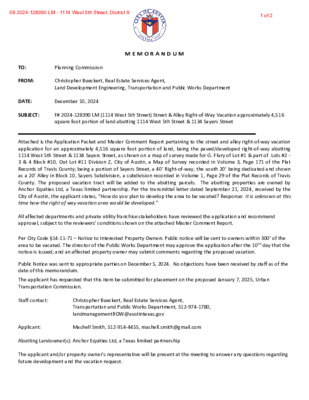
TO: Planning Commission M E M O R A N D U M FROM: Christopher Bueckert, Real Estate Services Agent, Land Development Engineering, Transportation and Public Works Department DATE: December 10, 2024 SUBJECT: F# 2024-128390 LM (1114 West 5th Street) Street & Alley Right-of-Way Vacation approximately 4,516 square foot portion of land abutting 1114 West 5th Street & 1134 Sayers Street Attached is the Application Packet and Master Comment Report pertaining to the street and alley right-of-way vacation application for an approximately 4,516 square foot portion of land, being the paved/developed right-of-way abutting 1114 West 5th Street & 1134 Sayers Street, as shown on a map of survey made for G. Flury of Lot #1 & part of Lots #2 - 3 & 4 Block #10, Out Lot #11 Division Z, City of Austin, a Map of Survey recorded in Volume 3, Page 171 of the Plat Records of Travis County; being a portion of Sayers Street, a 40’ Right-of-way, the south 20’ being dedicated and shown as a 20’ Alley in Block 10, Sayers Subdivision, a subdivision recorded in Volume 1, Page 29 of the Plat Records of Travis County. The proposed vacation tract will be added to the abutting parcels. The abutting properties are owned by Anchor Equities Ltd, a Texas limited partnership. Per the transmittal letter dated September 21, 2024, received by the City of Austin, the applicant states, “How do you plan to develop the area to be vacated? Response: It is unknown at this time how the right of way vacation area would be developed.” All affected departments and private utility franchise stakeholders have reviewed the application and recommend approval, subject to the reviewers’ conditions shown on the attached Master Comment Report. Per City Code §14-11-71 – Notice to Interested Property Owners Public notice will be sent to owners within 300’ of the area to be vacated. The director of the Public Works Department may approve the application after the 10 th day that the notice is issued; and an affected property owner may submit comments regarding the proposed vacation. Public Notice was sent to appropriate parties on December 5, 2024. No objections have been received by staff as of the date of this memorandum. The applicant has requested that this item be submitted for placement on the proposed January 7, 2025, Urban Transportation Commission. Staff contact: Christopher Bueckert, Real Estate Services Agent, Transportation and …
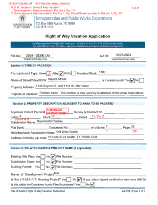
09 2024-128390 LM - 1114 West 5th Street; District 91 of 31 09 2024-128390 LM - 1114 West 5th Street; District 92 of 31 09 2024-128390 LM - 1114 West 5th Street; District 93 of 31 Right of Way Vacation Transmittal Letter LandManagementROW@AustinTexas.gov | Phone: 311 (or 512-974-2000 outside Austin) Forsubmittal and feeinformation, see www.austintexas.gov/department/land-management Provideareasonforthevaca�onbyansweringthefollowingques�ons:1.PropertyType:Residen�alCommercial2.Howwasheareaobevacaeddedicaed?PlaSeparaeInstrument3.DidheCiypurchaseheareaobevacaed?(i.e.,bySreeDeed)YesNo4.Arebohheareaobevacaedandyourproperyinhesame“subdivision”?(Theymusbohbeinhesamesubdivisionobeeligible.)YesNo5.Isheareaobevacaeda:Func�onalrigh-of-wayOnlydedicaedonpaper6.Arehereanyu�liylineswihinheareaobevacaed?YesNoIfyes,whaareyourplansforheu�li�es?___________________________________________________________________________________________________________________________________Applicansshouldbeadvisedhaeasemenswillbereainedoproecexis�ngu�li�es,evenifu�liyreloca�onisproposed.Alsobeadvisedhanosrucuresmaybebuilon,overorunderheeasemenswihoualicenseagreemen,insurance,andannualfee.7.Howdoyouplanodevelopheareaobevacaed?_______________________________________________________________________________________________________________________8.Hasasieplanbeensubmittedonyourprojec?YesNo9.IsyourprojecaUnifiedDevelopmen?YesNo10.IsyourprojecaS.M.A.R.T.HousingProjec?YesNo11.Whendoyouan�cipaesar�ngconsruc�onofhedevelopmen?________________________12.Whaishecurrenzoningonheadjacenproper�es?_________________________________13.Whaishecurrensausofheadjacenproper�es?__________________________________14.Whaypeofparkingfacili�escurrenlyexis?________________________________________15.Willyourparkingrequiremensincreasewihheexpansion?YesNo16.Howwillheincreasebehandled?__________________________________________________________________________________________________________________________________Utilities will stay in place. Property owner acknoweasments will be retained as partof Deed without WarrantyIt is unknown at this time how theright of way vacation area would be developedUnknownCS MU CO NP and CS MU V CO Small retail storesPaved parking lotN/A09 2024-128390 LM - 1114 West 5th Street; District 94 of 31 Right of Way Vacation Transmittal Letter LandManagementROW@AustinTexas.gov | Phone: 311 (or 512-974-2000 outside Austin) Forsubmittal and feeinformation, see www.austintexas.gov/department/land-management 17.Haveanyagreemensoreasemensbeenexecuedwihadjacenlandowner(s)orindraform?YesNoIfyes,pleaseprovideuswihacopy.18.DoesheareaobevacaedliewihinheAus�nDownownPlan(DAP)?YesNoIfyes,doesimeeDAPcrieria?YesNo19.DoesheareaobevacaedliewihinUTboundaries:EasofLamarBoulevard,wesofIH35,norhofMar�nLuherKingBoulevard,andsouhof45hSree?YesNo20.Doesheproposedvaca�onsupporhePrioriyProgramsandpolicydirec�vesseforhinheImagineAus�nComprehensivePlan?YesNoIfyes,how__________________________________________________________________________________________________________________________________________________________If you have questions; please email Land Management Department: LandManagementROW@AustinTexas.gov Continue to grow Austin's economy by investing in our workforce,education systems, entrepreneurs, and local businesses09 2024-128390 LM - 1114 West 5th Street; District 95 of 31 Right of Way Vacation Transmittal Letter LandManagementROW@AustinTexas.gov | Phone: 311 (or 512-974-2000 outside Austin) Forsubmittal and feeinformation, see www.austintexas.gov/department/land-management Provideareasonforthevaca�onbyansweringthefollowingques�ons:1.PropertyType:Residen�alCommercial2.Howwasheareaobevacaeddedicaed?PlaSeparaeInstrument3.DidheCiypurchaseheareaobevacaed?(i.e.,bySreeDeed)YesNo4.Arebohheareaobevacaedandyourproperyinhesame“subdivision”?(Theymusbohbeinhesamesubdivisionobeeligible.)YesNo5.Isheareaobevacaeda:Func�onalrigh-of-wayOnlydedicaedonpaper6.Arehereanyu�liylineswihinheareaobevacaed?YesNoIfyes,whaareyourplansforheu�li�es?___________________________________________________________________________________________________________________________________Applicansshouldbeadvisedhaeasemenswillbereainedoproecexis�ngu�li�es,evenifu�liyreloca�onisproposed.Alsobeadvisedhanosrucuresmaybebuilon,overorunderheeasemenswihoualicenseagreemen,insurance,andannualfee.7.Howdoyouplanodevelopheareaobevacaed?_______________________________________________________________________________________________________________________8.Hasasieplanbeensubmittedonyourprojec?YesNo9.IsyourprojecaUnifiedDevelopmen?YesNo10.IsyourprojecaS.M.A.R.T.HousingProjec?YesNo11.Whendoyouan�cipaesar�ngconsruc�onofhedevelopmen?________________________12.Whaishecurrenzoningonheadjacenproper�es?_________________________________13.Whaishecurrensausofheadjacenproper�es?__________________________________14.Whaypeofparkingfacili�escurrenlyexis?________________________________________15.Willyourparkingrequiremensincreasewihheexpansion?YesNo16.Howwillheincreasebehandled?__________________________________________________________________________________________________________________________________Utilities will stay in place. Property owner acknoweasments will be retained as partof Deed without WarrantyIt is unknown at this time how theright of way vacation area would be developedUnknownCS MU CO NP and CS MU V CO Small retail storesPaved parking lotN/A09 2024-128390 LM - 1114 West 5th Street; District 96 of 31 Right of Way Vacation Transmittal Letter LandManagementROW@AustinTexas.gov | Phone: 311 (or 512-974-2000 outside Austin) Forsubmittal and feeinformation, see www.austintexas.gov/department/land-management 17.Haveanyagreemensoreasemensbeenexecuedwihadjacenlandowner(s)orindraform?YesNoIfyes,pleaseprovideuswihacopy.18.DoesheareaobevacaedliewihinheAus�nDownownPlan(DAP)?YesNoIfyes,doesimeeDAPcrieria?YesNo19.DoesheareaobevacaedliewihinUTboundaries:EasofLamarBoulevard,wesofIH35,norhofMar�nLuherKingBoulevard,andsouhof45hSree?YesNo20.Doesheproposedvaca�onsupporhePrioriyProgramsandpolicydirec�vesseforhinheImagineAus�nComprehensivePlan?YesNoIfyes,how__________________________________________________________________________________________________________________________________________________________If you have questions; please email Land Management Department: LandManagementROW@AustinTexas.gov Continue to grow Austin's economy by investing in our workforce,education systems, entrepreneurs, and local businesses09 2024-128390 LM - 1114 West 5th Street; District 97 of 31 PropertyProfileROWvacationrequestSayersSt.LegendPropertyAddressesJurisdictionFULLPURPOSEJurisdictionsFillJurisdictionFULLPURPOSENotesBetween1134SayersSt.and1114W.5th0150300ftThisproductisforinformationalpurposesandmaynothavebeenpreparedfororbesuitableforlegal,engineering,orsurveyingpurposes.Itdoesnotrepresentanon-the-groundsurvey.ThisproducthasbeenproducedbytheCityofAustinforthesolepurposeofgeographicreference.NowarrantyismadebytheCityofAustinregardingspecificaccuracyorcompleteness.9/21/202409 2024-128390 LM - 1114 West 5th Street; District 98 of 31 P:\01924\Metes&Bounds&Certifications\01924_NORTH.docxPage1of19/26/24TBPLSFirm#10174300POBox90876Austin,TX78709512.537.2384www.4wardls.comEXHIBIT“______”(Right-Of-WayVacation)LegalDescriptionBEINGADESCRIPTIONOFATRACTOFLANDCONTAINING0.0517ACRE(2,253SQUAREFEET),BEINGAPORTIONOFSAYERSSTREET,A40’RIGHT-OF-WAYANDSHOWNASAPORTIONOFACALLED40’STREETINMAPOFSURVEYMADEFORG.FLURYOFLOT#1&PARTOFLOTS#2-3&4BLOCK#10,OUTLOT#11DIVISIONZ,CITYOFAUSTIN,AMAPOFSURVEYRECORDEDINVOLUME3,PAGE171OFTHEPLATRECORDSOFTRAVISCOUNTY,TEXAS(P.R.T.C.T.),SAID0.0517ACREBEINGMOREPARTICULARLYDESCRIBEDBYMETESANDBOUNDSASFOLLOWS:BEGINNING,ata1/2-inchironpipefoundintheeastlineofLot18,Block1,LauraP.Duval’sSubdivisionoftheeasthalfofLotNo.1,Division“Z”oftheOutlotsAdjoiningtheCityofAustin,asubdivisionofTravisCounty,TexasrecordedinVolume1,Page23(P.R.T.C.T.),forthesouthwestcornerofacalled0.303acretractdescribedas“Tract1”alsobeingthesouthwest120feetx100feetofLot4,Block10,Raymond’sPlateau,asubdivisionofTraviscounty,Texas,recordedinVolume1,Page30,(P.R.T.C.T.)conveyedtoAnchorEquities,LTD.InDocumentNo.2013206747oftheOfficialPublicrecordsofTravisCounty,Texas(O.P.R.T.C.T.),beingthenorthwestterminusofsaidSayersstreetandPOINTOFBEGINNINGhereof,fromwhicha1/2-inchironpipefoundinthewestlineofsaidAnchorEquities“Tract1”,forthenortheastcornerofsaidLot18bears,N21°50’59”E,adistanceof51.85feet;THENCE,withthenorthright-of-waylineofsaidSayersStreetandthesouthlineofsaidAnchorEquities“Tract1”,S67°45'43"E,adistanceof112.03feettoacalculatedpointforthenortheastcornerhereof,fromwhicha1/2-inchironrodfoundforthesoutheastcornerofsaidAnchorEquities“Tract1”andananglepointinthewestlineofLot1,ElmSquareAddition,asubdivisionofTravisCounty,Texas,recordedinVolume85,Page74C(P.R.T.C.T.)bears,S67°45'43"E,adistanceof7.30feet;THENCE,leavingthecommonlineofsaidSayersstreetandsaidAnchorEquities“Tract1”,overandacrosssaidSayersstreetthefollowingtwo(2)coursesanddistances:1)S22°16'54"W,adistanceof20.07feettoacalculatedpointforthesoutheastcornerhereof,2)N67°43'45"W,adistanceof112.90feettoacalculatedpointintheeastlineofLot19,ofsaidBlock1,LauraP.Duval’sSubdivisionandthewestright-of-waylineofsaidSayersstreetforthesouthwestcornerhereof,THENCE,inpartwiththeeastlinesofsaidLot18andsaidLot19,Block1,LauraP.Duval’sSubdivision,andthewestright-of-waylineofsaidSayersstreetN24°45'13"E,adistanceof20.02feettothePOINTOFBEGINNINGandcontaining0.0517Acre(2,253SquareFeet)ofland,moreorless.Notes:AllbearingsarebasedontheTexasStatePlaneCoordinateSystem,GridNorth,CentralZone(4203);alldistanceswereadjustedtosurfaceusingacombinedscalefactorof1.000060558237.Seeattachedsketch(referencedrawing:01924_NORTH.dwg.)_______________________________JasonWard,RPLS#58114WardLandSurveying,LLC12/09/2409 2024-128390 LM - 1114 West 5th Street; District 99 of 31 SAYERSSTREET(40'R.O.W.)W5THSTREET(R.O.W.VARIES)POBox90876,AustinTexas78709INFO@4WARDLS.COM(512)537-2384TBPELSFIRM#10174300ALimitedLiabilityCompany0.0517ACRER.O.W.VACATIONCityofAustinTravisCounty,Texas09 2024-128390 LM - 1114 West 5th Street; District 910 of 31 0.0517ACRER.O.W.VACATIONEASEMENTTravisCounty,TexasPOBox90876,AustinTexas78709INFO@4WARDLS.COM(512)537-2384TBPELSFIRM#10174300ALimitedLiabilityCompany09 2024-128390 LM - 1114 West 5th Street; District 911 of 31 P:\01924\Metes&Bounds&Certifications\01924_SOUTH.docxPage1of2TBPLSFirm#10174300POBox90876Austin,TX78709512.537.2384www.4wardls.comEXHIBIT“______”(Right-Of-WayVacation)LegalDescriptionBEINGADESCRIPTIONOFATRACTOFLANDCONTAINING0.0520ACRE(2,263SQUAREFEET),BEINGAPORTIONOFSAYERSSTREET,A40’RIGHT-OF-WAY,THESOUTH20’BEINGDEDICATEDANDSHOWNASA20’ALLEYINBLOCK10,SAYERSSUBDIVISION,ASUBDIVISIONRECORDEDINVOLUME1,PAGE29OFTHEPLATRECORDSOFTRAVISCOUNTY,TEXAS(P.R.T.C.T.),SAID0.0520ACREBEINGMOREPARTICULARLYDESCRIBEDBYMETESANDBOUNDSASFOLLOWS:COMMENCING,ata1/2-inchironpipefoundinthenorthright-of-waylineofW.5thstreet(right-of-wayvaries),forthesoutheastcornerofacalled0.174acretractdescribedas“Tract2”alsobeingthenorth66.7feetofLots8and9,Block1,SayersSubdivision,asubdivisionofTravisCounty,Texas,recordedinVolume1Page29(P.R.T.C.T.)andconveyedtoAnchorEquities,LTD.InDocumentNo.2013206747,oftheOfficialPublicRecordsofTravisCounty,Texas(O.P.R.T.C.T.),forthesouthwestcornerofacalled3,333.5squarefeettractoflandtobededicatedasSayersstreet,conveyedtotheCityofAustininVolume8271,Page812,oftheDeedRecordsofTravisCounty,Texas(D.R.T.C.T),fromwhicha1/2-inchironrodfoundforananglepointinthenorthlineofsaidW.5thstreet,alsobeingintheeastlineofLot20,Block1,LauraP.Duval’sSubdivisionoftheeasthalfofLotNo.1,Division“Z”oftheOutlotsAdjoiningtheCityofAustin,asubdivisionofTravisCounty,TexasrecordedinVolume1,Page23(P.R.T.C.T.)andbeingthesouthwestcornerofsaidAnchorEquities“Tract2”bears,N67°52’12”W,adistanceof113.94feet;THENCE,withthecommonlineofsaidAnchorEquities“Tract2”andsaidCityofAustintract,N22°14'01"E,adistanceof66.56feettoacalculatedpointforthecommonnorthcornerofsaidAnchorEquities“Tract2”andsaidCityofAustintract,forananglepointinthesouthright-of-waylineofsaidSayersstreet,forthePOINTOFBEGINNINGhereof,THENCE,withthecommonlineofsaidSayersstreetandsaidAnchorEquities“Tract2”,N67°41'49"W,adistanceof113.79feettoa1/2-inchironrodfoundintheeastlineofLot19,ofsaidBlock1,LauraP.Duval’ssubdivision,forthesouthwestterminusofsaidSayersstreetandforthenorthwestcornerofsaidAnchorEquities“Tract2”forthesouthwestcornerhereof,THENCE,withthecommonlineofsaidLot19,andsaidSayersstreet,N24°45'13"E,adistanceof19.95feettoacalculatedpointforthenorthwestcornerhereof,fromwhicha1/2-inchironpipefoundintheeastlineofLot18,ofsaidBlock1,LauraP.Duval’sSubdivision,forthesouthwestcornerofacalled0.303acretractdescribedas“Tract1”alsobeingthesouthwest120feetx100feetofLot4,Block10,Raymond’sPlateau,asubdivisionofTraviscounty,Texas,recordedinVolume1,Page30,(P.R.T.C.T.)conveyedtoAnchorEquities,LTD.InDocumentNo.2013206747(O.P.R.T.C.T.),beingthenorthwestterminusofsaidSayersstreetbears,N24°45'13"E,adistanceof20.02feet,THENCE,leavingtheeastlineofsaidLot19,overandacrosssaidSayersstreetthefollowingtwo(2)coursesanddistances:09 2024-128390 LM - 1114 West 5th Street; District 912 of 31 P:\01924\Metes&Bounds&Certifications\01924_SOUTH.docxPage2of29/26/241)S67°43'45"E,adistanceof112.90feettoacalculatedpointforthenortheastcornerhereof,2)S22°11'23"W,adistanceof20.00feettothePOINTOFBEGINNINGandcontaining0.0520Acre(2,263SquareFeet)ofland,moreorless.Notes:AllbearingsarebasedontheTexasStatePlaneCoordinateSystem,GridNorth,CentralZone(4203);alldistanceswereadjustedtosurfaceusingacombinedscalefactorof1.000060558237.Seeattachedsketch(referencedrawing:01924_SOUTH.dwg.)_______________________________JasonWard,RPLS#58114WardLandSurveying,LLC12/09/2409 2024-128390 LM - 1114 West 5th Street; District 913 of 31 W5THSTREET(R.O.W.VARIES)SAYERSSTREET(40'R.O.W.)POBox90876,AustinTexas78709INFO@4WARDLS.COM(512)537-2384TBPELSFIRM#10174300ALimitedLiabilityCompany0.0520ACRER.O.W.VACATIONCityofAustinTravisCounty,Texas09 2024-128390 LM - 1114 West 5th Street; District 914 of 31 POBox90876,AustinTexas78709INFO@4WARDLS.COM(512)537-2384TBPELSFIRM#10174300ALimitedLiabilityCompany0.0520ACRER.O.W.VACATIONCityofAustinTravisCounty,Texas09 2024-128390 LM - 1114 West 5th Street; District 915 of 31 09 2024-128390 LM - 1114 West 5th Street; District 916 of 31 …
PLANNING COMMISSION REGULAR MEETING MINUTES TUESDAY, DECEMBER 10, 2024 The Planning Commission convened in a regular meeting on Tuesday, December 10, 2024, at Austin City Hall, Council Chambers, Room 1001, 301 W. Second Street, in Austin, Texas. Chair Hempel called the Planning Commission meeting to order at 6:03 p.m. Board Members/Commissioners in Attendance: Claire Hempel Awais Azhar Casey Haney Adam Haynes Ryan Johnson Alberta Phillips Felicity Maxwell Danielle Skidmore Alice Woods Board Members/Commissioners in Attendance Remotely: Greg Anderson Nadia Barrera-Ramirez Grayson Cox Patrick Howard PUBLIC COMMUNICATION: GENERAL Carol Pennington – Regarding Hays Commons APPROVAL OF MINUTES 1. Approve the minutes of the Planning Commission regular meeting on November 12, 2024, and November 19, 2024. 1 The public hearing was closed on Vice Chair Azhar’s motion, Commissioner Wood’s second on a 11-0 vote. Commissioners Anderson was off the dais. Commissioner Haney was absent. The minutes from the meeting of November 12, 2024, were approved on the consent agenda on Vice Chair Azhar’s motion, Commissioner Woods’ second, on a 11-0 vote. Commissioners Anderson and Haney were off the dais. PUBLIC HEARINGS 2. Plan Amendment: NPA-2024-0015.01 - Gunter Street Rezoning; District 1 Location: 1143 3/4, 1145, 1145 1/2 Gunter Street, 3605 Abbate Circle, and 1144 Wayneroy Drive, Boggy Creek Watershed; East MLK (MLK) Combined Neighborhood Planning Area Owner/Applicant: RCG Gunter LLC and REAL Holdings LLC Agent: Request: Staff Rec.: Staff: Husch Blackwell LLP (Nikelle Meade) Single Family to Multifamily Residential land use Staff Recommends Multifamily Residential Maureen Meredith, 512-974-2695, maureen.meredith@austintexas.gov Planning Department The public hearing was closed on Vice Chair Azhar’s motion, Commissioner Maxwell’s second, on an 11-0 vote. Commissioners Anderson and Cox were off the dais. The motion to approve Staff’s recommendation of Multifamily Residential for NPA- 2024-0015.01 - Gunter Street Rezoning, located at 1143 3/4, 1145, 1145 1/2 Gunter Street, 3605 Abbate Circle, and 1144 Wayneroy Drive, was approved on Commissioner Phillips’ motion, Vice Chair Azhar’s second, on a 12-0 vote. Commissioner Cox was off the dais. 3. Rezoning: Location: C14-2024-0109 - Gunter Street Rezoning; District 1 1143 3/4, 1145, 1145 1/2 Gunter Street, 3605 Abbate Circle, and 1144 Wayneroy Drive, Boggy Creek Watershed; East MLK (MLK) Combined Neighborhood Planning Area Owner/Applicant: RCG Gunter LLC and REAL Holdings LLC Agent: Request: Staff Rec.: Staff: Husch Blackwell LLP (Nikelle Meade) SF-3-NP to MF-3-NP and SF-6-NP Staff recommends MF-3-CO-NP and SF-6-NP Jonathan Tomko, 512-974-1057, jonathan.tomko@austintexas.gov Planning Department The public hearing was closed on …
December 4, 2024 Via Electronic Delivery Leah M. Bojo lbojo@drennergroup.com 512-807-2918 Ms. Lauren Middleton-Pratt Planning Department City of Austin 6310 Wilhelmina Delco Drive Austin, TX 78752 Dear Ms. Middleton-Pratt: Re: C14-2024-0111 and NPA-2024-0008.01 - Postponement request for the zoning and neighborhood plan amendment applications associated with the property located at 2600 E Martin Luther King Jr Boulevard, Austin, Texas (the “Property”). As representatives of the owner of the Property, we respectfully request a postponement of zoning case no. C14-2024-0111 and Neighborhood Plan Amendment (NPA) case no. NPA-2024- 0008.01 on the December 17, 2024 Planning Commission agenda to the February 11, 2025 Planning Commission agenda. Please let me know if you have any questions or if we can provide any additional information. Thank you for your time and attention to this matter. Sincerely, Leah M. Bojo cc: Jonathan Tomko, Planning Department (via electronic delivery) Maureen Meredith, Planning Department (via electronic delivery) Joi Harden, Planning Department (via electronic delivery) 2705 Bee Cave Road, Suite 100 | Austin, Texas 78746 | 512-807-2900 | www.drennergroup.com
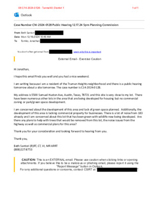
Case Number C14-2024-0128 Public Hearing 12.17.24 5pm Planning Commission Outlook From Beth Santori Date Mon 12/16/2024 10:49 AM To Tomko, Jonathan You don't often get email from . Learn why this is important External Email - Exercise Caution Hi Jonathan, I hope this email finds you well and you had a nice weekend. I am wri�ng because I am a resident of the Truman Heights neighborhood and there is a public hearing tomorrow about a site tomorrow. The case number is C14-2024-0128. My address is 5500 Samuel Huston Ave, Aus�n, Texas, 78721 and this site is very close to my lot. There have been numerous other lots in the area that are being developed for housing but no commercial zoning or park/green space development. I am concerned about the development of this area and lack of green space planned. Addi�onally, the development of this area is lacking commercial property for businesses. There is a lot of noise from 183 already and I am concerned about this lot that has been green with wildlife now being developed. Are there any plans to help with trees that would be removed from this lot, the noise issues from the highway as well as commercial plans for this area? Thank you for your considera�on and looking forward to hearing from you. Thank you, Beth Santori (R)RT, CT, VI, MR ARRT (808)227-8753 CAUTION: This is an EXTERNAL email. Please use caution when clicking links or opening attachments. If you believe this to be a malicious or phishing email, please report it using the "Report Message" button in Outlook. For any additional questions or concerns, contact CSIRT at " ". 06 C14-2024-0128 - Tannehill; District 1 1 of 1
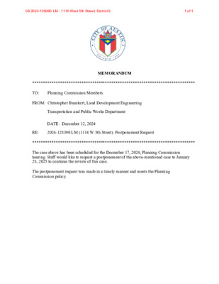
**************************************************************************** MEMORANDUM TO: Planning Commission Members FROM: Christopher Bueckert, Land Development Engineering Transportation and Public Works Department DATE: December 12, 2024 RE: 2024-128390 LM (1114 W 5th Street). Postponement Request **************************************************************************** The case above has been scheduled for the December 17, 2024, Planning Commission hearing. Staff would like to request a postponement of the above-mentioned case to January 28, 2025 to continue the review of this case. The postponement request was made in a timely manner and meets the Planning Commission policy. 09 2024-128390 LM - 1114 West 5th Street; District 9 1 of 1
Tyler Grooms | Principal | Manifold Real Estate CAUTION: This is an EXTERNAL email. Please use caution when clicking links or opening attachments. If you believe this to be a malicious or phishing email, please report it using the "Report Message" button in Outlook. For any additional questions or concerns, contact CSIRT at "cybersecurity@austintexas.gov". 2
Play video
REGULAR MEETING of the PLANNING COMMISSION TUESDAY, DECEMBER 10, 2024, 6:00 PM AUSTIN CITY HALL, COUNCIL CHAMBERS, ROOM 1001 301 WEST 2ND STREET AUSTIN, TEXAS Some members of the Planning Commission may be participating by videoconference. The meeting may be viewed online at: http://www.austintexas.gov/page/watch-atxn-live. Public comment will be allowed in-person or remotely via telephone. Speakers may only register to speak on an item once either in-person or remotely. Registration no later than 2 PM the day of the meeting is required for remote participation by telephone. For more information on public comment, please see the agenda section “Speaker Registration”. Please contact Ella Garcia, Staff Liaison, for questions regarding speaker registration at LandUseLiaison@austintexas.gov or by phone at 512-978-0821. CURRENT BOARD MEMBERS/COMMISSIONERS: Claire Hempel, Chair (District 8) Awais Azhar, Vice Chair (Mayor’s Representative) Greg Anderson, Secretary (District 4) Alice Woods, Parliamentarian (District 2) Patrick Howard (District 1) Nadia Barrera-Ramirez (District 3) Felicity Maxwell (District 5) EX-OFFICIO MEMBERS: Casey Haney (District 6) Ryan Johnson (District 7) Danielle Skidmore (District 9) Grayson Cox (District 10) Alberta Phillips (Mayor’s Representative) Adam Haynes (Mayor’s Representative) Jessica Cohen, Chair of Board of Adjustment Candace Hunter, AISD Board of Trustees TC Broadnax, City Manager Richard Mendoza – Director of Transportation and Public Works Executive Liaison: Joi Harden, 512-974-1617 Staff Liaison: Ella Garcia, 512-978-0821 Attorney: Steve Maddoux, 512-974-6080 APPROVAL OF MINUTES 1. Approve the minutes of the Planning Commission regular meeting on November 12, 2024, and November 19, 2024. PUBLIC HEARINGS 2. Plan Amendment: NPA-2024-0015.01 - Gunter Street Rezoning; District 1 Location: 1143 3/4, 1145, 1145 1/2 Gunter Street, 3605 Abbate Circle, and 1144 Wayneroy Drive, Boggy Creek Watershed; East MLK (MLK) Combined Neighborhood Planning Area Owner/Applicant: RCG Gunter LLC and REAL Holdings LLC Agent: Request: Staff Rec.: Staff: Husch Blackwell LLP (Nikelle Meade) Single Family to Multifamily Residential land use Staff Recommends Multifamily Residential Maureen Meredith, 512-974-2695, maureen.meredith@austintexas.gov Planning Department 3. Rezoning: Location: C14-2024-0109 - Gunter Street Rezoning; District 1 1143 3/4, 1145, 1145 1/2 Gunter Street, 3605 Abbate Circle, and 1144 Wayneroy Drive, Boggy Creek Watershed; East MLK (MLK) Combined Neighborhood Planning Area Owner/Applicant: RCG Gunter LLC and REAL Holdings LLC Agent: Request: Staff Rec.: Staff: Husch Blackwell LLP (Nikelle Meade) SF-3-NP to MF-3-NP and SF-6-NP Staff recommends MF-3-CO-NP and SF-6-NP Jonathan Tomko, 512-974-1057, jonathan.tomko@austintexas.gov Planning Department 4. Plan Amendment: NPA-2024-0015.03 - Cherrylawn Rezoning; District 1 Location: 6102, 6106, and 6108 Cherrylawn Circle, Little Walnut Creek Watershed; …
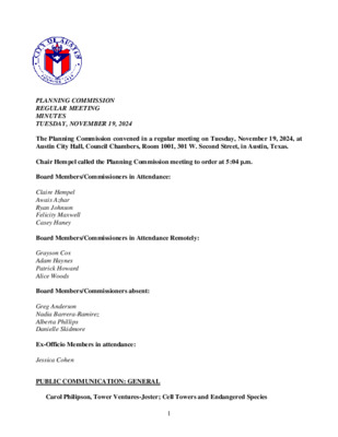
PLANNING COMMISSION REGULAR MEETING MINUTES TUESDAY, NOVEMBER 19, 2024 The Planning Commission convened in a regular meeting on Tuesday, November 19, 2024, at Austin City Hall, Council Chambers, Room 1001, 301 W. Second Street, in Austin, Texas. Chair Hempel called the Planning Commission meeting to order at 5:04 p.m. Board Members/Commissioners in Attendance: Claire Hempel Awais Azhar Ryan Johnson Felicity Maxwell Casey Haney Board Members/Commissioners in Attendance Remotely: Grayson Cox Adam Haynes Patrick Howard Alice Woods Board Members/Commissioners absent: Greg Anderson Nadia Barrera-Ramirez Alberta Phillips Danielle Skidmore Ex-Officio Members in attendance: Jessica Cohen PUBLIC COMMUNICATION: GENERAL Carol Philipson, Tower Ventures-Jester; Cell Towers and Endangered Species 1 APPROVAL OF MINUTES Approve the minutes of the Planning Commission regular meeting on November 12, 2024. The minutes from the meeting of November 12, 2024, were postponed until December 10, 2024, on the consent agenda on Vice Chair Azhar’s motion, Commissioner Maxwell’s second, on a 9-0 vote. Commissioners Anderson, Barrera-Ramirez, Phillips, and Skidmore were absent. PUBLIC HEARINGS 2. Plan Amendment: NPA-2024-0015.01 - Gunter Street Rezoning; District 1 Location: 1143 3/4, 1145, 1145 1/2 Gunter Street, 3605 Abbate Circle, and 1144 Wayneroy Drive, Boggy Creek Watershed; East MLK (MLK) Combined Neighborhood Planning Area Owner/Applicant: RCG Gunter LLC and REAL Holdings LLC Agent: Request: Staff Rec.: Staff: Husch Blackwell LLP (Nikelle Meade) Single Family to Multifamily Residential land use Staff recommends Multifamily Residential Maureen Meredith, 512-974-2695, maureen.meredith@austintexas.gov Planning Department The motion to approve the Planning Commission’s postponement request to December 10, 2024, was approved on the consent agenda on Vice Chair Azhar’s motion, Commissioner Maxwell’s second, on a 9-0 vote. Commissioners Anderson, Barrera- Ramirez, Phillips, and Skidmore were absent. 3. Rezoning: Location: C14-2024-0109 - Gunter Street Rezoning; District 1 1143 3/4, 1145, 1145 1/2 Gunter Street, 3605 Abbate Circle, and 1144 Wayneroy Drive, Boggy Creek Watershed; East MLK (MLK) Combined Neighborhood Planning Area Owner/Applicant: RCG Gunter LLC and REAL Holdings LLC Agent: Request: Staff Rec.: Staff: Husch Blackwell LLP (Nikelle Meade) SF-3-NP to MF-3-NP and SF-6-NP Staff recommends MF-3-CO-NP and SF-6-NP Jonathan Tomko, 512-974-1057, jonathan.tomko@austintexas.gov Planning Department The motion to approve the Planning Commission’s postponement request to December 10, 2024, was approved on the consent agenda on Vice Chair Azhar’s motion, Commissioner Maxwell’s second, on a 9-0 vote. Commissioners Anderson, Barrera- Ramirez, Phillips, and Skidmore were absent. 1. 2 4. Plan Amendment: NPA-2023-0017.01 - Anderson Square, District 4 Location: 910, 912, 914 & 916, 1012 & …
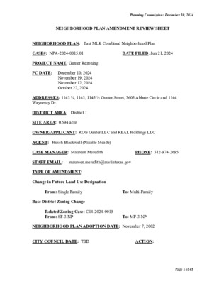
Planning Commission: December 10, 2024 NEIGHBORHOOD PLAN AMENDMENT REVIEW SHEET NEIGHORHOOD PLAN: East MLK Combined Neighborhood Plan CASE#: NPA-2024-0015.01 PROJECT NAME: Gunter Rezoning PC DATE: December 10, 2024 November 19, 2024 November 12, 2024 October 22, 2024 DATE FILED: Jun 21, 2024 ADDRESS/ES: 1143 ¾, 1145, 1145 ½ Gunter Street, 3605 Abbate Circle and 1144 Wayneroy Dr. DISTRICT AREA: District 1 SITE AREA: 0.594 acre OWNER/APPLICANT: RCG Gunter LLC and REAL Holdings LLC AGENT: Husch Blackwell (Nikelle Meade) CASE MANAGER: Maureen Meredith STAFF EMAIL: maureen.meredith@austintexas.gov TYPE OF AMENDMENT: Change in Future Land Use Designation From: Single Family Base District Zoning Change To: Multi-Family Related Zoning Case: C14-2024-0019 From: SF-3-NP To: MF-3-NP NEIGHBORHOOD PLAN ADOPTION DATE: November 7, 2002 CITY COUNCIL DATE: TBD ACTION: PHONE: 512-974-2695 Page 1 of 45 Planning Commission: December 10, 2024 PLANNING COMMISSION RECOMMENDATION: December 10, 2024 - (action pending) November 19, 2024 – Postponed to December 10, 2024 at the request of the Planning Commission. [A. Azhar – 1st; F. Maxwell – 2nd] Vote: 9-0 [G. Anderson, N. Barrera- Ramirez, D. Skidmore and A. Phillips absent. G. Cox voted no on Items #4 and 5]. November 12, 2024 – After discussion, postponed to November 19, 2024 hearing due to posting language error. [A. Azhar – 1st; D. Skidmore – 2nd] Vote: 10-2 [A. Haynes and A. Phillips voted nay. G. Cox absent]. October 22, 2024 - Postponed to November 12, 2024 on the consent agenda at the request of the Applicant and the Neighborhood. [A. Woods 1st; F. Maxwell – 2nd] Vote: 13-0. STAFF RECOMMENDATION: Staff supports the applicant’s request for Multifamily Residential land use. BASIS FOR STAFF’S RECOMMENDATION: Staff supports the applicant’s request Multifamily Residential land use because the property is near Airport Blvd and Springdale Road which are activity corridors. The applicant proposes approximately 47 residential units which will provide housing options for the area and the city. There is Multifamily Residential directly to the east. Page 2 of 45 Planning Commission: December 10, 2024 The neighborhood plan supports infill housing in the planning area. The plan also supports maintaining single family zoning, but the proposed development will provide more housing for the city. LAND USE DESCRIPTIONS: EXISTING LAND USE: Single family - Single family detached or up to three residential uses at typical urban and/or suburban densities. Purpose 1. Preserve the land use pattern and future viability of existing neighborhoods; 2. Encourage new …
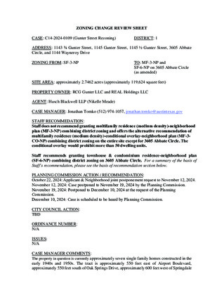
ZONING CHANGE REVIEW SHEET CASE: C14-2024-0109 (Gunter Street Rezoning) DISTRICT: 1 ADDRESS: 1143 ¾ Gunter Street, 1145 Gunter Street, 1145 ½ Gunter Street, 3605 Abbate Circle, and 1144 Wayneroy Drive ZONING FROM: SF-3-NP TO: MF-3-NP and SF-6-NP on 3605 Abbate Circle (as amended) SITE AREA: approximately 2.7462 acres (approximately 119,624 square feet) PROPERTY OWNER: RCG Gunter LLC and REAL Holdings LLC AGENT: Husch Blackwell LLP (Nikelle Meade) CASE MANAGER: Jonathan Tomko (512) 974-1057, jonathan.tomko@austintexas.gov STAFF RECOMMEDATION: Staff does not recommend granting multifamily residence (medium density)-neighborhood plan (MF-3-NP) combining district zoning and offers the alternative recommendation of multifamily residence (medium density)-conditional overlay-neighborhood plan (MF-3- CO-NP) combining district zoning on the entire site except for 3605 Abbate Circle. The conditional overlay would prohibit more than 50 dwelling units. Staff recommends granting townhouse & condominium residence-nei ghborhood plan (SF-6-NP) combining district zoning on 3605 Abbate Circle. For a summary of the basis of Staff’s recommendation, please see the basis of recommendation section below. PLANNING COMMISSION ACTION / RECOMMENDATION: October 22, 2024: Applicant & Neighborhood joint postponement request to November 12, 2024. November 12, 2024: Case postponed to November 19, 2024 by the Planning Commission. November 19, 2024: Postponed to December 10, 2024 at the request of the Planning Commission. December 10, 2024: Case is scheduled to be heard by Planning Commission. CITY COUNCIL ACTION: TBD ORDINANCE NUMBER: N/A ISSUES: N/A CASE MANAGER COMMENTS: The property in question is currently approximately seven single family homes constructed in the early 1940s and 1950s. The tract is approximately 550 feet east of Airport Boulevard, approximately 550 feet south of Oak Springs Drive, approximately 600 feet west of Springdale C14-2024-0109 2 Road, and approximately 800 feet north of the intersection of Airport Boulevard and Gunter Street. Airport Boulevard is an ASMP level 3 roadway, an Imagine Austin Activity Corridor and a part of the transit priority network. Springdale Road is an ASMP level 2 roadway, an Imagine Austin Activity Corridor and a part of the transit priority network. Oak Springs Drive is an ASMP level 2 roadway, and a part of the transit priority network. The tract is approximately 550 feet north of the Springdale Station Imagine Austin Activity Center. Sidewalks exist along the length of Gunter Street and Munson Street, sidewalks and recently upgraded bicycle infrastructure exists along Oak Springs Drive and Springdale Road. Two high frequency bus routes (every 15-30 minutes) are proximate to the …
Outlook Opposition to Further Postponements of the Cherrylawn Zoning Case From Shirley Lee-Terry < > Date Tue 12/3/2024 10:24 AM To John Leigh < < < < >; EMLKCT Chair < >; Lawler, John < >; Mays, Sharon < >; Meredith, Maureen < >; Alexandria Anderson < >; Tomko, Jonathan >; Byrd, Eric >; Howard, Patrick - BC < >; PSS NA VP > External Email - Exercise Caution Dear Mr. Tomko, I am writing to express my concerns regarding the Cherrylawn Zoning and NPA cases (C14-2024-0122 and NPA- 2024-0015.03), initially filed on August 26, 2024. As a homeowner in the affected neighborhood, I am deeply frustrated by the repeated request for postponements requested by the applicant, Mr. Emerson Smith( which one request on November 12, 2024has already been granted), and the lack of equitable treatment afforded to homeowners in opposition. Notification and Homeowner Rights The notification process for this case was insufficient. Neighbors within 500 feet were given limited information and inadequate guidance on how to advocate for our rights. Meanwhile, the applicant’s rights and interests seem to have been prioritized at the expense of the community. It feels as though homeowners are stripped of their voices when a developer requests rezoning. This undermines trust in the process and fosters a perception of bias. Pattern of Bad Faith by the Applicant Since the first postponement, Mr. Smith has acted in bad faith, including: 1. Contacting neighbors to purchase their homes immediately after a postponement was granted on November 12, 2024. Mr. Smith contacted the homeowner at 6100 Cherrylawn Circle and 6107 Cherrylawn Circle on November 13, 2024, one day after being granted a postponement. 2. Showing duplex plans to a neighbor as a veiled threat to pressure rezoning approval. Stating he is underwater on all 4 of the homes he has purchased on Cherrylawn Circle ...then privately continues to contact other Cherrylawn Circle homeowners to purchase their homes. 3. Falsely claiming to be in active negotiations with neighbors to address their concerns. 4. Filing the request to rezone as a business owner of 3 Tech companies needing office space for his employees. His attorney stated (in the virtual community meeting) on September 19, 2024, that the 3 tech companies are now actually only one, and they verified Mr. Smith is a developer. These actions clearly demonstrate that the applicant is not engaging in good-faith discussions with the neighborhood. Instead, …
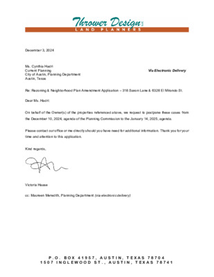
December 3, 2024 Ms. Cynthia Hadri Current Planning City of Austin, Planning Department Austin, Texas Dear Ms. Hadri: Via Electronic Delivery Re: Rezoning & Neighborhood Plan Amendment Application – 318 Saxon Lane & 6328 El Mirando St. On behalf of the Owner(s) of the properties referenced above, we request to postpone these cases from the December 10, 2024, agenda of the Planning Commission to the January 14, 2025, agenda. Please contact our office or me directly should you have need for additional information. Thank you for your time and attention to this application. Kind regards, Victoria Haase cc: Maureen Meredith, Planning Department (via electronic delivery) P . O . B O X 4 1 9 5 7 , A U S T I N , T E X A S 7 8 7 0 4 1 5 0 7 I N G L E W O O D S T . , A U S T I N , T E X A S 7 8 7 4 1
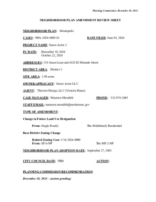
Planning Commission: December 10, 2024 NEIGHBORHOOD PLAN AMENDMENT REVIEW SHEET DATE FILED: June 03, 2024 NEIGHORHOOD PLAN: Montopolis CASE#: NPA-2024-0005.01 PROJECT NAME: Saxon Acres 2 PC DATE: December 10, 2024 October 22, 2024 ADDRESS/ES: 318 Saxon Lane and 6328 El Mirando Street DISTRICT AREA: District 3 SITE AREA: 2.89 acres OWNER/APPLICANT: Saxon Acres LLC AGENT: Thrower Design, LLC (Victoria Haase) CASE MANAGER: Maureen Meredith STAFF EMAIL: maureen.meredith@austintexas.gov TYPE OF AMENDMENT: Change in Future Land Use Designation From: Single Family Base District Zoning Change To: Multifamily Residential Related Zoning Case: C14-2024-0099 From: SF-6-NP NEIGHBORHOOD PLAN ADOPTION DATE: September 27, 2001 CITY COUNCIL DATE: TBD PLANNING COMMISSION RECOMMENDATION: December 10, 2024 – (action pending) ACTION: To: MF-2-NP PHONE: 512-974-2695 Planning Commission: December 10, 2024 October 22, 2024 – Postponed to December 10, 2024 on the consent agenda at the request of the Neighborhood. STAFF RECOMMENDATION: Staff does not support the applicant’s request for Multifamily Residential land use. BASIS FOR STAFF’S RECOMMENDATION: Staff does not support the appliant’s request for Multifamily Residential land use because staff has concerns about the limited vehicular access on Saxon Lane. The surrounding land uses are Single Family to the north, south and west of the property, with commercial land use to the east, across from Saxon Lane (proposed for Mixed Use in case NPA-2022-0005.01_Vargas Mixed Use). Although staff supported the Mixed Use land use on the adjacent property, because of the access issues with Saxon Lane, staff does not support increasing the density of the subject tract. See associated zoning case report C14-2024-0099 for details. The Montopolis Neighborhood Plan supports the creation of housing for all stages of life and also the preservation of single family housing. The proposed rezoning to MF-2-NP would add more housing to the planning area; however, the zoning staff case report details the issues regarding the vehicular access and impact on Saxon Lane which resulted in non- support for the proposed zoning change. Page 2 of 24 Planning Commission: December 10, 2024 LAND USE DESCRIPTIONS: EXISTING LAND USE: Single family - Single family detached or up to three residential uses at typical urban and/or suburban densities. Purpose 1. Preserve the land use pattern and future viability of existing neighborhoods; 2. Encourage new infill development that continues existing neighborhood patterns of development; and 3. Protect residential neighborhoods from incompatible business or industry and the loss of existing housing. Application 1. Existing single‐family areas …
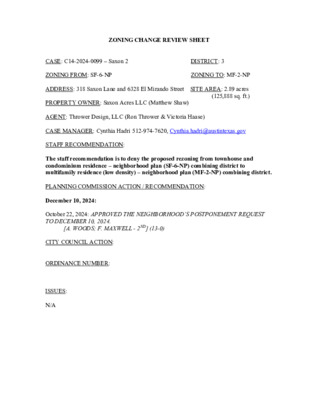
ZONING CHANGE REVIEW SHEET DISTRICT: 3 ZONING TO: MF-2-NP CASE: C14-2024-0099 – Saxon 2 ZONING FROM: SF-6-NP ADDRESS: 318 Saxon Lane and 6328 El Mirando Street SITE AREA: 2.89 acres (125,888 sq. ft.) PROPERTY OWNER: Saxon Acres LLC (Matthew Shaw) AGENT: Thrower Design, LLC (Ron Thrower & Victoria Haase) CASE MANAGER: Cynthia Hadri 512-974-7620, Cynthia.hadri@austintexas.gov STAFF RECOMMENDATION: The staff recommendation is to deny the proposed rezoning from townhouse and condominium residence – neighborhood plan (SF-6-NP) combining district to multifamily residence (low density) – neighborhood plan (MF-2-NP) combining district. PLANNING COMMISSION ACTION / RECOMMENDATION: December 10, 2024: October 22, 2024: APPROVED THE NEIGHBORHOOD’S POSTPONEMENT REQUEST TO DECEMBER 10, 2024. [A. WOODS; F. MAXWELL - 2ND] (13-0) CITY COUNCIL ACTION: ORDINANCE NUMBER: ISSUES: N/A C14-2024-0099 2 CASE MANAGER COMMENTS: The property in question is approximately 2.89 acres, undeveloped and has one proposed access on Saxon Lane (level 1) but El Mirando Street (level 1) is adjacent to the property. The site is currently zoned townhouse and condominium residence – neighborhood plan (SF- 6-NP). The property has single family residential (SF-3-NP and LR-NP) to the north, south, east and west. There are multifamily residences, East Vue Ranch Apartments, (CS-MU-CO- NP) to the east. The properties to the north and west have various commercial uses, office uses and churches (LO-NP, LR-NP and GR-NP). To the east across Vargas Road are daycare facilities and storage facilities (GR-NP and CS-NP). The site is within 0.25 miles from a bus stop on El Mirando Street, however, trying to access would not be the most feasible option if there is not an access proposed to this street.The applicant did not provide trip counts for El Mirando Street when submitting counts for the Neighborhood Traffic Analysis Memo and it will not have vehicular access proposed. Please refer to Exhibits A (Zoning Map) and B (Aerial View). Due to the history on this site and the lack of improved infrastructure, staff is recommending the denial for the rezoning to multifamily residence (low density) – neighborhood plan (MF- 2-NP) combining district. This property previously sought a rezoning in 2020 from SF-3-NP to SF-6-NP. In the four-year time frame since this previously granted rezoning, there have been no updates to the property or the surrounding area. The property continues to be undeveloped and the road unimproved. The Neighborhood Traffic Analysis (NTA) Memo states that traffic on a residential local or collector street …
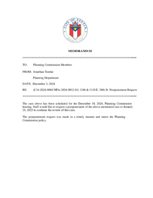
**************************************************************************** MEMORANDUM TO: Planning Commission Members FROM: Jonathan Tomko Planning Department DATE: December 3, 2024 RE: (C14-2024-0048/NPA-2024-0012.01) 1106 & 1110 E. 30th St. Postponement Request **************************************************************************** The case above has been scheduled for the December 10, 2024, Planning Commission hearing. Staff would like to request a postponement of the above-mentioned case to January 28, 2025 to continue the review of this case. The postponement request was made in a timely manner and meets the Planning Commission policy.
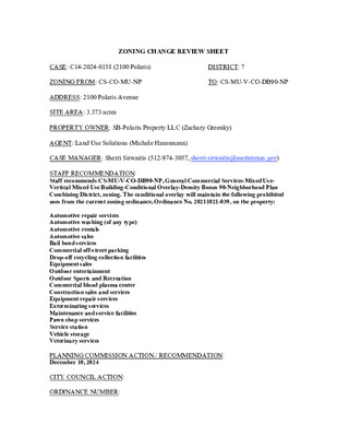
ZONING CHANGE REVIEW SHEET CASE: C14-2024-0158 (2100 Polaris) DISTRICT: 7 ZONING FROM: CS-CO-MU-NP TO: CS-MU-V-CO-DB90-NP ADDRESS: 2100 Polaris Avenue SITE AREA: 3.373 acres PROPERTY OWNER: SB-Polaris Property LLC (Zachary Greenky) AGENT: Land Use Solutions (Michele Haussmann) CASE MANAGER: Sherri Sirwaitis (512-974-3057, sherri.sirwaitis@austintexas.gov) STAFF RECOMMENDATION: Staff recommends CS-MU-V-CO-DB90-NP, General Commercial Services-Mixed Use- Vertical Mixed Use Building-Conditional Overlay-Density Bonus 90-Neighborhood Plan Combining District, zoning. The conditional overlay will maintain the following prohibited uses from the current zoning ordinance, Ordinance No. 20211021-039, on the property: Automotive repair services Automotive washing (of any type) Automotive rentals Automotive sales Bail bond services Commercial off-street parking Drop-off recycling collection facilities Equipment sales Outdoor entertainment Outdoor Sports and Recreation Commercial blood plasma center Construction sales and services Equipment repair services Exterminating services Maintenance and service facilities Pawn shop services Service station Vehicle storage Veterinary services CITY COUNCIL ACTION: ORDINANCE NUMBER: PLANNING COMMISSION ACTION / RECOMMENDATION: December 10, 2024 C14-2024-0158 ISSUES: 2 In December 2023, Ordinance No. 20220609-080, Ordinance No. 20221201-056 and Ordinance No. 20221201-055 were invalidated. On March 11, 2024, Ordinance No. 20240229-073, was enacted to create the “DB90” combining district, which amended City Code Title 25 (Land Development) to create a new zoning district for a density bonus program that grants 30 feet in height above the base zoning district, to a maximum of 90 feet, and modifies site development regulations including compatibility standards. Subsequently, the applicant submitted this new rezoning application to request the -DB90 combining district. CASE MANAGER COMMENTS: The property in question is a 3+ acre tract of land located at the terminus of Polaris Avenue. This currently vacant site was previously used as demolition company (Heart of Texas Demolition LLC). To the north, there are commercial and light industrial uses. The lot to the south is developed with a public school (Burnet Middle School). There is a rail line to the east. To the west, there are office/warehouse buildings to the north of Polaris Avenue and a multifamily complex, a townhouse residence, a duplex and single family residences to the south of Polaris Avenue. The applicant is requesting a rezoning the property to add the “V” and “DB90” combining districts to the existing zoning to redevelop the property with approximately 350 multifamily residential units (please see Applicant’s Request Letter – Exhibit C). There are transportation options in this area as there are Capital Metro bus routes along Burnet Road (#3 and #803) …
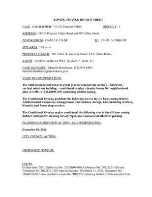
ZONING CHANGE REVIEW SHEET DISTRICT: 3 TO: CS-MU-V-DB90-NP CASE: C14-2024-0145 – 518 N. Pleasant Valley ADDRESS: 518 N. Pleasant Valley Road and 507 Calles Street ZONING FROM: CS-MU-V-CO-NP SITE AREA: 3.81 acres PROPERTY OWNER: 507 Calles St. (Austin) Owner, LLC (Shaul Kuba) AGENT: Armbrust & Brown PLLC (Richard T. Suttle, Jr.) CASE MANAGER: Marcelle Boudreaux (512-974-8094, marcelle.boudreaux@austintexas.gov) STAFF RECOMMENDATION: The Staff recommendation is to grant general commercial services – mixed use - vertical mixed use building – conditional overlay - density bonus 90 - neighborhood plan (CS-MU-V-CO-DB90-NP) combining district zoning. The Conditional Overlay prohibits the following uses in the CS base zoning district: Adult-oriented businesses, Campground, Convenience storage, Exterminating services, Kennels, and Pawn shop services. The Conditional Overlay makes conditional the following uses in the CS base zoning district: Automotive washing (of any type), and Commercial off-street parking. PLANNING COMMISSION ACTION / RECOMMENDATION: December 10, 2024: CITY COUNCIL ACTION: ORDINANCE NUMBER: ISSUES: In December 2023, Ordinance No. 20220609-080, Ordinance No. 20221201-056 and Ordinance No. 20221201-055 were invalidated. On March 11, 2024, Ordinance No. 20240229-073, was enacted to create the “DB90” combining district, which amended City C14-2024-0145 Page 2 Code Title 25 (Land Development) to create a new zoning district for a density bonus program that grants 30 feet in height above the base zoning district, to a maximum of 90 feet, and modifies site development regulations including compatibility standards. Subsequently, the applicant submitted this new rezoning application to request the -DB90 combining district. The conditions establishing conditional and prohibited uses in the Conditional Overlay for case number C14-2023-0011 are continued to be recommended in this new rezoning. The conditional and prohibited uses were established for the site during the neighborhood plan rezonings. Planning Commission Previous Action December 12, 2023: Approved CS-MU-V-CO-NP combining district zoning as staff recommended, by consent. [F. MAXWELL; A. AZHAR– 2ND] (11-0) N. BARRERA-RAMIREZ, P. HOWARD – ABSENT City Council Previous Action February 1, 2024: Approved CS-MU-V-CO-NP combining district zoning as Planning Commission recommended, after Staff read CO into record. VOTE: 11-0. Prior Rezoning Case C14-2023-0111 Ordinance No. 20240201-040 approved February 1, 2024 CASE MANAGER COMMENTS: The 3.81 acres site is developed with an industrial building and fronts North Pleasant Valley Road to the east, which is an ASMP level 3 and Calles Street to the west, which is an ASMP level 1. To the south, the property is bounded by railroad tracks. To the north is …
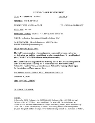
ZONING CHANGE REVIEW SHEET DISTRICT: 1 TO: CS-MU-V-CO-DB90-NP CASE: C14-2024-0149 – FiveOne ADDRESS: 5525 E. 51st Street ZONING FROM: CS-MU-V-CO-NP SITE AREA: 4.0 acres PROPERTY OWNER: 5525 E. 51st St. LLC (Charles Brewer III) AGENT: Ledgestone Development Group LLC (Craig Alter) CASE MANAGER: Marcelle Boudreaux (512-974-8094, marcelle.boudreaux@austintexas.gov) STAFF RECOMMENDATION: The Staff recommendation is to grant general commercial services – mixed use - vertical mixed use building – conditional overlay - density bonus 90 - neighborhood plan (CS-MU-V-CO-DB90-NP) combining district zoning. The Conditional Overlay prohibits the following uses in the CS base zoning district: Drive-in service as an accessory use to commercial uses, Automotive rentals, Automotive repair services, Automotive sales, Automotive washing (of any type), Service station, and Pawn shop services. PLANNING COMMISSION ACTION / RECOMMENDATION: December 10, 2024: CITY COUNCIL ACTION: ORDINANCE NUMBER: ISSUES: In December 2023, Ordinance No. 20220609-080, Ordinance No. 20221201-056 and Ordinance No. 20221201-055 were invalidated. On March 11, 2024, Ordinance No. 20240229-073, was enacted to create the “DB90” combining district, which amended City Code Title 25 (Land Development) to create a new zoning district for a density bonus program that grants 30 feet in height above the base zoning district, to a maximum of 90 feet, C14-2024-0149 Page 2 and modifies site development regulations including compatibility standards. Subsequently, the applicant submitted this new rezoning application to request the -DB90 combining district. The conditions establishing prohibited uses in the CS base zoning district within the Conditional Overlay for case number C14-2022-0009 are requested by the Applicant and are continued to be recommended by Staff in this new rezoning. These prohibited uses originated in a CO on this site during the Neighborhood Plan rezonings. Planning Commission Previous Action May 24, 2022: Approved CS-MU-V-NP combining district zoning as Applicant requested, with added Conditional Overlay with prohibited uses in the CS base zoning district recommended by Staff: Drive-in service as an accessory use to commercial uses, Automotive rentals, Automotive repair services, Automotive sales, Automotive washing (of any type), Service station, and Pawn shop services (CS-MU-V-CO-NP). [J. THOMPSON; P. HOWARD– 2ND] (8-0) A. AZHAR – ABSTAINED; C. HEMPEL, Y. FLORES, J. MUSHTALER, J. SHIEH - ABSENT May 10, 2022: Approved a Postponement Request by Applicant to May 24, 2022 [A. AZHAR; J. MUSHTALER – 2ND] (13-0) City Council Previous Action July 28, 2022: Approved CS-MU-V-CO-NP combining district zoning as Planning Commission recommended, by consent. VOTE: 10-0. Council Member Fuentes was off …
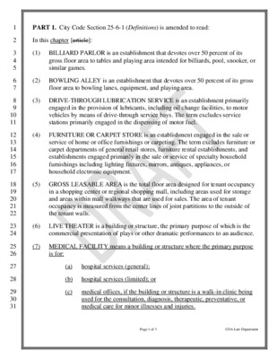
1 2 3 4 5 6 7 8 9 10 11 12 13 14 15 16 17 18 19 20 21 22 23 24 25 26 27 28 29 30 31 PART 1. City Code Section 25-6-1 (Definitions) is amended to read: In this chapter [article]: (1) BILLIARD PARLOR is an establishment that devotes over 50 percent of its gross floor area to tables and playing area intended for billiards, pool, snooker, or similar games. (2) BOWLING ALLEY is an establishment that devotes over 50 percent of its gross floor area to bowling lanes, equipment, and playing area. (3) DRIVE-THROUGH LUBRICATION SERVICE is an establishment primarily engaged in the provision of lubricants, including oil change facilities, to motor vehicles by means of drive-through service bays. The term excludes service stations primarily engaged in the dispensing of motor fuel. (4) FURNITURE OR CARPET STORE is an establishment engaged in the sale or service of home or office furnishings or carpeting. The term excludes furniture or carpet departments of general retail stores, furniture rental establishments, and establishments engaged primarily in the sale or service of specialty household furnishings including lighting fixtures, mirrors, antiques, appliances, or household electronic equipment. (5) GROSS LEASABLE AREA is the total floor area designed for tenant occupancy in a shopping center or regional shopping mall, including areas used for storage and areas within mall walkways that are used for sales. The area of tenant occupancy is measured from the center lines of joint partitions to the outside of the tenant walls. (6) LIVE THEATER is a building or structure, the primary purpose of which is the commercial presentation of plays or other dramatic performances to an audience. (7) MEDICAL FACILITY means a building or structure where the primary purpose is for: (a) hospital services (general); (b) hospital services (limited); or (c) medical offices, if the building or structure is a walk-in clinic being used for the consultation, diagnosis, therapeutic, preventative, or medical care for minor illnesses and injuries. Page 1 of 3 COA Law Department 32 33 34 35 36 37 38 39 40 41 42 43 44 45 46 47 48 49 50 51 52 53 54 55 56 57 58 59 60 61 62 63 64 (8[7]) MOTION PICTURE THEATER is a building or structure, the primary purpose of which is the commercial presentation of motion pictures to an audience. (9) PEDESTRAIN ENTRANCE means a functional …
C20-2024-039 Bollard Installation For Medical Facilities Danielle Morin, AICP | Program Manager | December 10, 2024 Presentation Overview • Background • Council Resolution • Code Amendment • Criteria/Rule • Schedule • Questions/Answers 12/5/2024 2 City Council Resolution 20240718-092 BE IT RESOLVED BY THE CITY COUNCIL OF THE CITY OF AUSTIN: City Council initiates amendments to City Code, including Title 25 (Land Development), to require the installation of crash-rated bollards or other similar safety barriers to prevent vehicle-into-building crashes at the pedestrian entrances of medical facilities with nearby vehicular traffic. City Council Resolution 20240718-092 “BE IT FURTHER RESOLVED: When proposing amendments initiated by this Resolution, the City Manager is directed to explore: 1. the feasibility of requiring safety barriers in public right-of-way areas adjacent to medical facilities to enhance pedestrian safety and prevent vehicle crashes; 2. whether permit applications to expand, remodel, or upgrade existing facilities can trigger this requirement to install safety bollards; incentives for existing facilities to voluntarily comply with new City requirements to install bollards; 3. 4. 5. recommendations for the City's state and federal legislative agenda; and any other necessary changes that achieve the objectives of this resolution. BE IT FURTHER RESOLVED: The City Manager is directed to engage with stakeholders, including medical facility operators, with the goal of bringing about compliance with any new requirements City Council adopts.” Changes to Title 25 LDC Chapter 25-6, Transportation Modify LDC 25-6-1 (Definitions) (7) MEDICAL FACILITY means a building or structure where the primary purpose is for: (a) hospital services (general); (b) hospital services (limited); or (c) medical offices, if the building or structure is a walk-in clinic being used for the consultation, diagnosis, therapeutic, preventative, or medical care for minor illnesses and injuries. (9) PEDESTRIAN ENTRANCE means a functional entrance or door that is publicly accessible and designed for pedestrian use. Changes to Title 25 Create a new Section in 25-6 (Transportation) 25-6-324 PEDESTRIAN SAFETY BARRIERS FOR MEDICAL FACILITIES (A) This section applies to a development application for new construction of a medical facility. (B) An applicant is required to install security bollards in front of each pedestrian entrance to a medical facility in accordance with the Transportation Criteria Manual. (C) The installation of security bollards cannot obstruct accessible routes or accessible means of ingress and egress to the pedestrian entrance. (D) The director may waive this requirement if the applicant demonstrates the walkway to the pedestrian entrance …
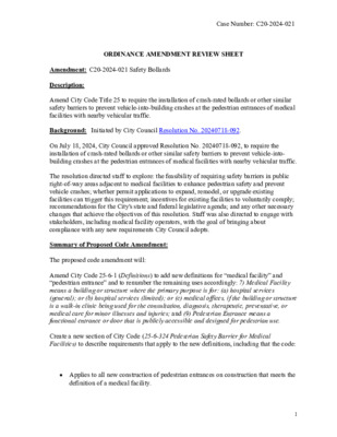
Case Number: C20-2024-021 ORDINANCE AMENDMENT REVIEW SHEET Amendment: C20-2024-021 Safety Bollards Description: Amend City Code Title 25 to require the installation of crash-rated bollards or other similar safety barriers to prevent vehicle-into-building crashes at the pedestrian entrances of medical facilities with nearby vehicular traffic. Background: Initiated by City Council Resolution No. 20240718-092. On July 18, 2024, City Council approved Resolution No. 20240718-092, to require the installation of crash-rated bollards or other similar safety barriers to prevent vehicle-into- building crashes at the pedestrian entrances of medical facilities with nearby vehicular traffic. The resolution directed staff to explore: the feasibility of requiring safety barriers in public right-of-way areas adjacent to medical facilities to enhance pedestrian safety and prevent vehicle crashes; whether permit applications to expand, remodel, or upgrade existing facilities can trigger this requirement; incentives for existing facilities to voluntarily comply; recommendations for the City's state and federal legislative agenda; and any other necessary changes that achieve the objectives of this resolution. Staff was also directed to engage with stakeholders, including medical facility operators, with the goal of bringing about compliance with any new requirements City Council adopts. Summary of Proposed Code Amendment: The proposed code amendment will: Amend City Code 25-6-1 (Definitions) to add new definitions for “medical facility” and “pedestrian entrance” and to renumber the remaining uses accordingly: 7) Medical Facility means a building or structure where the primary purpose is for: (a) hospital services (general); or (b) hospital services (limited); or (c) medical offices, if the building or structure is a walk-in clinic being used for the consultation, diagnosis, therapeutic, preventative, or medical care for minor illnesses and injuries; and (9) Pedestrian Entrance means a functional entrance or door that is publicly accessible and designed for pedestrian use. Create a new section of City Code (25-6-324 Pedestrian Safety Barrier for Medical Facilities) to describe requirements that apply to the new definitions, including that the code: • Applies to all new construction of pedestrian entrances on construction that meets the definition of a medical facility. 1 Case Number: C20-2024-021 • Refers applicants to technical guidance in Transportation Criteria Manual, to be posted in a subsequent rule. • Allows for alternative compliance if designed in a manner that mitigates the risk of vehicular crashes into the pedestrian entrance. Proposed Text Amendment(s): See attached draft ordinance. Staff Recommendation: Recommended Staff recommends the proposed Pedestrian Safety Barrier for Medical Facilities language for inclusion …
Overview of the Colorado River Protections Ordinance P l a n n i n g C o m m i s s i o n D e c e m b e r 1 0 , 2 0 2 4 C I T Y O F A U S T I N W A T E R S H E D P R O T E C T I O N D E P A R T M E N T Introduction One simple change to the Land Development Code: Change the Erosion Hazard Zone from 100 to 200 feet, downstream of Longhorn Dam Plus introduce: Improve drainage design rules to reduce extreme bank erosion C I T Y O F A U S T I N W A T E R S H E D P R O T E C T I O N D E P A R T M E N T 2 2-Minute Summary Video C I T Y O F A U S T I N W A T E R S H E D P R O T E C T I O N D E P A R T M E N T 3 Ordinance Youtube video link Council Resolution Community members asked Council to strengthen Colorado River protections; Council thereafter included in their June 2022 Council resolution: “… evaluate the effectiveness of existing Critical Water Quality Zone and Erosion Hazard Zone buffers on the Colorado River downstream of the Longhorn Dam and to propose protections that will provide adequate protections to the river that will ensure a healthy riparian corridor to stabilize the riverbank and protect property from erosion” C I T Y O F A U S T I N W A T E R S H E D P R O T E C T I O N D E P A R T M E N T 4 East Austin Longhorn Dam J. Trevino Metro Park Lady Bird Lake Roy Guerrero Park “Dog’s Head” Southeast Austin Parcel Count Juris- diction Type Acres CWQZ Buffer Acres 400ft Buffer Acres Austin’s Full Purpose (City) Limits 1,054 14,896 15,950 391 2,184 2,575 281 1,929 2,211 241 243 484 50% 50% 100% 7% 93% 100% 13% 87% 100% 15% 85% 100% Acres 400ft minus CWQZ 109 255 ABIA 364 30% 70% 100% FULL ETJ Totals FULL ETJ Totals Hornsby Bend Biosolids Plant …
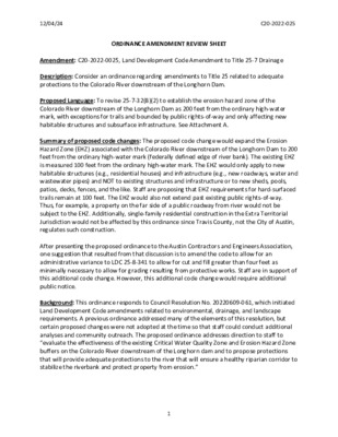
12/04/24 C20-2022-025 ORDINANCE AMENDMENT REVIEW SHEET Amendment: C20-2022-0025, Land Development Code Amendment to Title 25-7 Drainage Description: Consider an ordinance regarding amendments to Title 25 related to adequate protections to the Colorado River downstream of the Longhorn Dam. Proposed Language: To revise 25-7-32(B)(2) to establish the erosion hazard zone of the Colorado River downstream of the Longhorn Dam as 200 feet from the ordinary high-water mark, with exceptions for trails and bounded by public rights-of-way and only affecting new habitable structures and subsurface infrastructure. See Attachment A. Summary of proposed code changes: The proposed code change would expand the Erosion Hazard Zone (EHZ) associated with the Colorado River downstream of the Longhorn Dam to 200 feet from the ordinary high-water mark (federally defined edge of river bank). The existing EHZ is measured 100 feet from the ordinary high-water mark. The EHZ would only apply to new habitable structures (e.g., residential houses) and infrastructure (e.g., new roadways, water and wastewater pipes) and NOT to existing structures and infrastructure or to new sheds, pools, patios, decks, fences, and the like. Staff are proposing that EHZ requirements for hard-surfaced trails remain at 100 feet. The EHZ would also not extend past existing public rights-of-way. Thus, for example, a property on the far side of a public roadway from river would not be subject to the EHZ. Additionally, single-family residential construction in the Extra Territorial Jurisdiction would not be affected by this ordinance since Travis County, not the City of Austin, regulates such construction. After presenting the proposed ordinance to the Austin Contractors and Engineers Association, one suggestion that resulted from that discussion is to amend the code to allow for an administrative variance to LDC 25-8-341 to allow for cut and fill greater than four feet as minimally necessary to allow for grading resulting from protective works. Staff are in support of this additional code change. However, this additional code change would require additional public notice. Background: This ordinance responds to Council Resolution No. 20220609-061, which initiated Land Development Code amendments related to environmental, drainage, and landscape requirements. A previous ordinance addressed many of the elements of this resolution, but certain proposed changes were not adopted at the time so that staff could conduct additional analyses and community outreach. The proposed ordinance addresses direction to staff to “evaluate the effectiveness of the existing Critical Water Quality Zone and Erosion Hazard Zone buffers on …
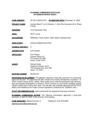
PLANNING COMMISSION SITE PLAN EXTENSION REVIEW SHEET CASE NUMBER: SP-2014-0262C(XT3) PC MEETING DATE: December 10, 2024 PROJECT NAME: Lantana Block P, Lot 3 (Revision 1) (Site Plan Extension #2 of Phase 5 Only) ADDRESS: 7415 Southwest Pkwy AREA: 35.671 acres WATERSHED: Williamson Creek, Barton Creek (Barton Springs Zone) AREA STUDY: Lantana Neighborhood Park COUNCIL DISTRICT: 8 JURISDICTION: Full Purpose APPLICANT: Erin Pickens Lantana Place LLC 212 Lavaca St # 300 Austin, Texas 78701 AGENT: Richard Suttle Armbrust & Brown, PLLC 100 Congress Ave, Ste 1300 Austin, TX 78701 EXISTING ZONING: GR-MU-NP PROPOSED DEVELOPMENT: The applicant requests a three-year extension for a previously approved site plan. The approved site plan includes the existing development of phases 1-4, which contains access drives, utilities, water quality pond, retail and associated improvements, and the proposed development of phase 5, which contains (2) multi-family buildings totaling 125,801 square feet of gross floor area. The site plan was originally approved with SP-2014- 0262C and modified by the Project Consent Agreement (Ordinance No. 20200521-050). STAFF RECOMMENDATION: Staff recommends the requested three-year extension. PLANNING COMMISSION ACTION: The Planning Commission approved a three-year extension, to April 30, 2022, at the June 25, 2019 hearing. CASE MANAGER: Gabriel Guerrero Jr. Telephone: (512) 978-4658 gabriel.guerrero@austintexas.gov PREVIOUS APPROVALS: The site plan was granted a one year administratively approved extension from April 30, 2018 to April 30, 2019 (SP-2014-0262C(XT)). The site plan was then granted a three-year Commission-approved extension to 2022 (SP-2014-0262C(XT2)). The Project Consent Agreement (Ordinance No. 20200521-050) modified the expiration date so that the site plan expired on April 30, 2024. Then a one year administratively approved extension was granted from April 30, 2024 to April 30, 2025 (SP-2014-0262C(XT1)(B)) per the Project Consent Agreement (Ord. No. 20200521-050) Part 2(C) and City Code Sec. 25-5- 62 (Extension of Released Site Plan by Director). PROJECT INFORMATION: SITE AREA: 35.671 acres MAX. BLDG. COVERAGE: 75% MAX. IMPERV. CVRG: 90% MAX. HEIGHT: 60 Ft EXIST. ZONING: GR-MU-NP PROP. BLDG CVRG: 6.37 ac. (17.85%) PROP. IMP. CVRG: 17.34 acres (48.6%) PROP. HEIGHT: 60 Ft A COMPARISON OF THE APPROVED PROJECT WITH CURRENT REGULATIONS WATERSHED ORDINANCE: This project complies with applicable watershed regulations. LAND USE: The site plan complies with all applicable zoning regulations. ENVIRONMENTAL: All environmental comments have been cleared. The design has been updated to reflect changes due to Atlas 14. TRANSPORTATION: All transportation comments have been cleared. SURROUNDING CONDITIONS: Zoning/ Land Use North: ROW, …
ORDINANCE NO. 20220728-163 AN ORDINANCE AMENDING ORDINANCE NO. 910620-C TO MODIFY SUBDISTRICT USE AND DEVELOPMENT REGULATIONS FOR THE EAST 11TH STREET NEIGHBORHOOD CONSERVATION CON BIN NG DISTR CT (NCCD); AND REZONING AND CHANGING THE ZONING MAP FOR THE PROPERTY LOCATED ALONG THE NORTHBOUND FRONTAGE ROAD OF IH-35 BETWEEN THE NOtTICERN ALLEY OF THE 800-900 BLOCK OF EAST 7TH STREET AND EAST 12TH STREET, THE WEST SIDE OF THE 800-1000 BLOCKS OF SAN IVARCOS STREE-, EAST 11TH STREET FROM IH-35 TO NAVASOTA STREET, ALONG ROSEWOOD AVENUE FROM 11TH STREET TO APPROXIMATELY ANGELINA STREET, ALONG A SEGMENT OF THE 1200 BLOCK OF NAVASOTA STREET, AND ALONG THE EAST SIDE OF A SEGMENT OF THE 1500 AND 1600 BLOCK OF SAN BERNARD STREET IN THE CENTRAL EAST AUST N NE G-BOI OOD PLAN AREA. BE IT ORDAINED BY THE CITY COUNCIL OF THE CITY OF AUSTIN: PART 1. Ordinance No. 910620-C (the "Original NCCD Ordinance") established the East 11 th Street neighborhood conservation combining district (the "East 11 th Street NCCD") for the area generally from IH-35 eastward along the 11 th Street corridor to Angelina Street and an area along IH-35 from East 12th Street to 7th Street. This ordinance amends the Original NCCD Ordinance. PART 2. The Original NCCD Ordinance established three subdistricts within the East 11 th Street NCCD that were identified on Attachment 13 in the Original NCCD Ordinance. The Original NCCD Ordinance has been amended from time to time for certain properties within the NCCD, including Ordinance No. 20081211-080 that established a fourth subdistrict (Subdistrict 4). This ordinance removes Subdistrict 4 and reclassifies the properties as part of Subdistrict 1. PART 3. The zoning map established by Section 25-2-191 ofthe City Code is amended to amend the East 11 th Street NCCD, identified in the attached Exhibit "A" incorporated into this ordinance, to modify use and development regulations within the East 11 th Street NCCD on the property described in Zoning Case No. C14-2021-0033, on file at the Planning and Zoning Department, as follows: Page 1 of 22 Approximately 28 acres of land bounded by IH-35 between East 12th Street and the alley between East 8th Street and East 7th Street; the alley between East 8 th Street and East 7 th Street; Embassy Drive; San Marcos Street; the alley and rear property lines ofproperties fronting on East 11 th Street extending from San Marcos Street to Navasota …
ORDINANCE NO. 910620-c AN ORDINANCE ORDERING A REZONING AND CHANGING THE ZONING MAP ACCOMPANYING CHAPTER 13-2 (LAND USE) OF THE AUSTIN CITY CODE OF 1981 TO ESTABLISH AN EAST 111H STREET NEIGHBORHOOD CONSERVATION COMBINING DISTRICT WITHIN THE BOUNDARIES DEFINED BY THIS ORDINANCE; MODIFYING CERTAIN BASE DISTRICT USE, SITE DEVELOPMENT, AND PROCEDURAL REGULATIONS FOR PROPERTY INCLUDED IN THE EAST 11TH STREET NEIGHBORHOOD CONSERVATION COMBINING DISTRICT; CONTAINING OTHER PROVISIONS RELATING TO THE FOREGOING SUBJECT; PROVIDING FOR SEVERABILITY; WAIVING THE REQUIREMENT OF SEC. 2-2-3 OF THE AUSTIN CITY CODE OF 1981 THAT ORDINANCES BE READ ON THREE SEPARATE DAYS; AND PROVIDING AN EFFECTIVE DATE. BE IT ORDAINED BY THE CITY COUNCIL OF THE CITY OF AUSTIN: PARTI. The City Council finds that an application has been submitted by the neighborhood organization and the owners of certain property located in the East llth Street neighborhood to establish a Neighborhood Conservation Combining District ("NCCD") in accordance with and pursuant to applicable provisions of the Land Development Code; a Neighborhood Plan has been filed with the Director of the Department of Planning and Development; all required public hearings have been held and notices given as required by law; the recommendation of the Planning Commission has been duly considered; and the creation of an NCCD in the East llth Street area is in the public interest and will benefit the property owners and residents of the neighborhood and the City. The East llth Street Neighborhood Conservation Combining District (the "East llth PART 2. Street NCCD") is established, with its boundaries as shown on the maps attached and incorporated into this ordinance as Exhibit "A". The Zoning Map accompanying Chapter 13-2 (Land Use) of the Austin City Code of 1981 and made a part thereof is amended to establish the East llth Street NCCD in combination with the base zoning district previously established and existing for each property within the East llth Street NCCD. The use and development of property located within the East 11 th Street NCCD shall PART 3. conform with the use and site development regulations established by the applicable base zoning district and all other applicable regulations established by the Land Development Code, as such regulations may be modified by the NCCD regulations set forth in PART 4 of this ordinance. PART 4. (a) The applicable provisions of Tide XIII (Land Development Code) of the Austin City Code of 1981 are modified in the …
MINUTES URBAN RENEWAL BOARD MEETING September 16, 2024, 6:00 P.M. PERMITTING AND DEVELOPMENT CENTER, ROOM 1401/1402 6310 WILHELMINA DELCO DR. AUSTIN, TEXAS 78752 Jacqueline Watson Kobla Tetey Tam Hawkins CURRENT BOARD MEMBERS/COMMISSIONERS: Manuel Escobar, Chair Darrell W, Pierce, Vice Chair Amit Motwani Byron Davis Board Members/Commissioners in Attendance: Vice Chair Darrell W. Pierce, and Commissioners Kobla Tetey, and Byron Davis. Commissioner Tam Hawkins arrived at 6:21pm. Board Members/Commissioners in Attendance Remotely: No members attended remotely. Board Members Absent/off the dais at call to order: Commissioners Amit Motwani and Jacqueline Watson were absent. CALL TO ORDER: Chair Escobar, called the meeting to order at 6:09 pm with four members present. PUBLIC COMMUNICATION: GENERAL The first 10 speakers who registered to speak no later than noon the day before the meeting, if speaking virtually, or who signed up prior to the meeting being called to order if speaking in person, will each be allowed a three-minute allotment to address their concerns regarding items not posted on the agenda. Paul Stables addressed the board regarding a zoning change to his property adjacent to East 11th Street. 1 of 3 1. 2. 3. 4. APPROVAL OF MINUTES Approve the minutes of the Urban Renewal Board’s (URB’s) regular-called meeting on August 19, 2024. On Commissioner Tetey’s motion, Commissioner Davis’s second, the August 19, 2024, minutes were approved on a 4-0-0 vote. DISCUSSION ITEMS Discussion related to updates on future development of Blocks 16 & 18 from Rally Austin (formerly Austin Economic Development Corporation), including project status and anticipated timeline (Anne Gatling Haynes, Rally Austin) Anne Gatling Hayes, Rally Austin, gave the updates. Update and discussion related to the annual budget process (Mandy DeMayo, Interim Director, Housing Department) Mandy DeMayo, Interim Director, Housing Department, gave the update. Update and discussion regarding the African American Cultural Heritage District (AACHD) Resolution No. 20210902-048 (Matthew Schmidt, Global Business Expansion Division Program Manager III, Economic Development Department) Matthew Schmidt gave the update. Commissioner Byron Davis volunteered as representative to serve on the AACHD coalition. DISCUSSION AND ACTION ITEMS 5. Discuss and approve a recommendation to City Council regarding the request to amend the Urban Renewal Plan to allow additional uses at 1201 E 11th St (Paul Stables) Following discussion, on Chair Escobar’s motion, Vice Chair Pierce’s second, the URB voted to initiate the process to restore prior rights, to the same as when Paul Stables purchased his parcel, on a …

Outlook Opposition to Further Postponements of the Cherrylawn Zoning Case From Shirley Lee-Terry < > Date Tue 12/3/2024 10:24 AM To John Leigh < < < < >; EMLKCT Chair < >; Lawler, John < >; Mays, Sharon < >; Meredith, Maureen < >; Alexandria Anderson < >; Tomko, Jonathan >; Byrd, Eric >; Howard, Patrick - BC < >; PSS NA VP > External Email - Exercise Caution Dear Mr. Tomko, I am writing to express my concerns regarding the Cherrylawn Zoning and NPA cases (C14-2024-0122 and NPA- 2024-0015.03), initially filed on August 26, 2024. As a homeowner in the affected neighborhood, I am deeply frustrated by the repeated request for postponements requested by the applicant, Mr. Emerson Smith( which one request on November 12, 2024has already been granted), and the lack of equitable treatment afforded to homeowners in opposition. Notification and Homeowner Rights The notification process for this case was insufficient. Neighbors within 500 feet were given limited information and inadequate guidance on how to advocate for our rights. Meanwhile, the applicant’s rights and interests seem to have been prioritized at the expense of the community. It feels as though homeowners are stripped of their voices when a developer requests rezoning. This undermines trust in the process and fosters a perception of bias. Pattern of Bad Faith by the Applicant Since the first postponement, Mr. Smith has acted in bad faith, including: 1. Contacting neighbors to purchase their homes immediately after a postponement was granted on November 12, 2024. Mr. Smith contacted the homeowner at 6100 Cherrylawn Circle and 6107 Cherrylawn Circle on November 13, 2024, one day after being granted a postponement. 2. Showing duplex plans to a neighbor as a veiled threat to pressure rezoning approval. Stating he is underwater on all 4 of the homes he has purchased on Cherrylawn Circle ...then privately continues to contact other Cherrylawn Circle homeowners to purchase their homes. 3. Falsely claiming to be in active negotiations with neighbors to address their concerns. 4. Filing the request to rezone as a business owner of 3 Tech companies needing office space for his employees. His attorney stated (in the virtual community meeting) on September 19, 2024, that the 3 tech companies are now actually only one, and they verified Mr. Smith is a developer. These actions clearly demonstrate that the applicant is not engaging in good-faith discussions with the neighborhood. Instead, …
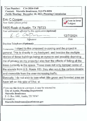
Backup
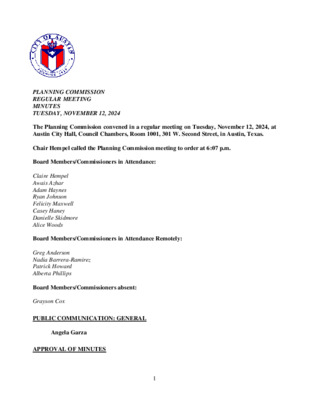
PLANNING COMMISSION REGULAR MEETING MINUTES TUESDAY, NOVEMBER 12, 2024 The Planning Commission convened in a regular meeting on Tuesday, November 12, 2024, at Austin City Hall, Council Chambers, Room 1001, 301 W. Second Street, in Austin, Texas. Chair Hempel called the Planning Commission meeting to order at 6:07 p.m. Board Members/Commissioners in Attendance: Claire Hempel Awais Azhar Adam Haynes Ryan Johnson Felicity Maxwell Casey Haney Danielle Skidmore Alice Woods Board Members/Commissioners in Attendance Remotely: Greg Anderson Nadia Barrera-Ramirez Patrick Howard Alberta Phillips Board Members/Commissioners absent: Grayson Cox PUBLIC COMMUNICATION: GENERAL Angela Garza APPROVAL OF MINUTES 1 Approve the minutes of the Planning Commission special called meeting on October 21, 2024, and regular meeting on October 22, 2024. The minutes from the meeting of October 21, 20204, and October 22, 2024, were approved on the consent agenda on Commissioner Skidmore’s motion, Vice Chair Azhar’s second, on a 12-0 vote. Commissioner Cox was absent. PUBLIC HEARINGS 2. Plan Amendment: NPA-2024-0015.02 - Seventh Day Adventist Alpha Church; Location: District 1 3016 East 51st Street; 3021 and 3039 Pecan Springs Road, Fort Branch Watershed; East MLK (Pecan Springs-Springdale) Combined Neighborhood Planning Area Owner/Applicant: Southwest Region Conference Association of Seventh Day Adventist & Southwest Region Conference of Seventh Day Adventist Armbrust & Brown, PLLC (Michael J. Whellan) Mixed Residential to Mixed Use land use Staff recommends Neighborhood Mixed Use Maureen Meredith, 512-974-2695, maureen.meredith@austintexas.gov Planning Department Agent: Request: Staff Rec.: Staff: The motion to approve the action taken at the Planning Commission regular meeting of October 22, 2024, as shown below, was approved on the consent agenda on Commissioner Skidmore’s motion, Vice Chair Azhar’s second, on a 12-0 vote. Commissioner Cox was absent. There was a motion by Commissioner Cox, seconded by Chair Hempel, to Staff’s recommendation of Neighborhood Mixed Use for NPA-2024-0015.02 - Seventh Day Alpha Church, located at 3016 East 51st Street; 3021 and 3039 Pecan Springs Road. The substitute motion to approve the Applicant’s request of Mixed Use land use for NPA-2024-0015.02 - Seventh Day Adventist Alpha Church, located at 3016 East 51st Street; 3021 and 3039 Pecan Springs Road, was approved on Commissioner Anderson’s motion, Commissioner Haney’s second on an 11-2 vote. Commissioners Cox and Skidmore voted nay. 1. 2 3. Rezoning: Location: C14-2024-0104 - Seventh Day Adventist Alpha Church; District 1 3016 East 51st Street; 3021 and 3039 Pecan Springs Road, Fort Branch Watershed; East MLK (Pecan Springs-Springdale) Combined Neighborhood Planning …