29 C20-2023-041 - Amendment to the North BurnetGateway Regulating Plan; District 7 Part 3.pdf — original pdf
Backup
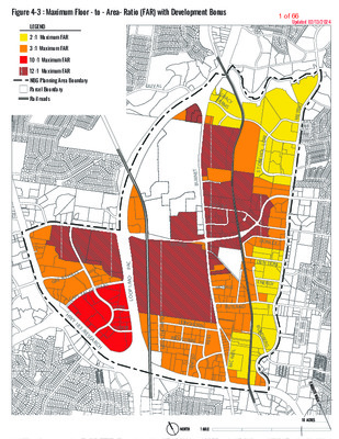
Figure 4-3 : Maximum Floor - to - Area- Ratio (FAR) with Development Bonus Updated 02/13/2024 LEGEND 2 :1 Maximum FAR 3 :1 Maximum FAR 10 :1 Maximum FAR 12 :1 Maximum FAR NBG Planning Area Boundary Parcel Boundary Rail roads DU V AL G R A F A R C Y M S C I R T E M W O L L O H E N O T S DONLEY DEN TON ENERGY R U N D B E R G T E N R U B KRAMER BRAKER MCHALE RUTLAND N O S P M O H T S L I E N LONGHORN INDUSTRIAL D I E R D E T I N U L I E N - C M S T O N E L A K E S L A T H I L E G R X A S E A L O F T T C A P I H W Y 1 8 3 / R E S E A R C H C A P - O M / 1 P O O L YORK TUDOR 1 of 66 Figure 4 - 4 : Maximum Height by Right (with no Development Bonus) Updated 02/13/2024 LEGEND Maximum Height 40 feet 60 feet 120 feet* See label on parcel for maximum height NBG Planning Area Boundary DUVAL Parcel Boundary Railroads *As regulated by Figure 4-1 RSMU for Life Science Uses G R A F A C Y R M S C I R T E M 25 ‘ W O L L O H E N O T S 35 ‘ DONLEY DENTON ENERGY R U N D B E R G T E N R U B BRAKER KRAMER MCHALE RUTLAND N O S P M O H T S L I E N LONGHORN INDUSTRIAL D I E R D E T I N U L I E N - C M 127’ 73’ 117’ C A P - O M / 1 P O O L 80 ‘ S T O N E L A K E L S L G R E A T H I 45 ‘ C A P I T A L O F T E X A S 90 ‘ 70 ‘ YORK H W 48 ‘ Y 1 8 3 / 70 ‘ 75 ‘ 55 ‘ TUDOR 75 ‘ R E S E A R C H Note : Maximum height by Right is based on the maximum height allowed by the property’s zoning prior to adoption of this Document. 2 of 66 Figure 4-5: Maximum Height with Development Bonus Updated 02/13/2024 LEGEND LEGEND Maximum Height 60 feet 120 feet 180 feet 350 feet 420 feet 491 feet NBG Planning Area Boundary Parcel Boundary Rail roads DU VAL G R A F A R C Y M S C I R T E M T E N R U B KRAMER BRAKER S T O N E L A K E S L A T H I L E G R X A S E A L O F T T C A P I H W Y 1 8 3 / R E S E A R C H C A P - O M / 1 P O O L YORK TUDOR MCHALE RUTLAND N O S P M O H T S L I E N LONGHORN INDUSTRIAL D I E R D E T I N U L I E N - C M W O L L O H E N O T S DONLEY DEN TON ENERGY R U N D B E R G 3 of 66 Figure 4-6 : North Burnet / Gateway (NBG) Zoning District Watershed and Maximum Impervious Cover Map Updated 02/13/2024 Maximum Impervious Cover LEGEND 60% 80% 95% See label on parcel for maximum impervious cover Watershed Boundary line NBG Planning Area Boundary Parcel Boundary DUVAL G R A F A C Y R M S C I R T E M W O L L O H E N O T S Walnut Creek Watershed (Suburban Watershed) T E N R U B KRAMER 90% 90% Shoal Creek Watershed (Urban Watershed) S T O N E L 70% A K E L S L 90% G R E A T H I 90% 85% C A P I T A L O F T E X A S 65% C A P - O M / 1 P O O L 70% 65% YORK 68% 74% TUDOR 85% H W Y 1 8 3 / R E S E A R C H BRAKER Little Walnut Creek Watershed (Urban Watershed) MCHALE DONLEY DENTON ENERGY RUTLAND N O S P M O H T S L I E N LONGHORN INDUSTRIAL D I E R D E T I N U L I E N - C M R U N D B E R G Note : - In the Urban Watersheds, maximum impervious cover is based on the property’s zoning prior to adoption of this Document. - Watershed boundary lines are approximate. Impervious cover limits will be verified when the urban or suburban watershed determination is made during the review process for a development application. 4 of 66 Article 4: Site Development Standards Section 4.3. Relationship of Buildings to Streets and Walkways Subsection 4.3.1. Purpose 4.3. RELATIONSHIP OF BUILDINGS TO STREETS AND WALKWAYS 4.3.1. Purpose This Document alters the standard manner of applying setbacks. Conventional zoning code applies a minimum building setback from the property line. However, with the NBG Master Plan, the goal is to build compact environments that are designed around the pedestrian where the street and buildings have a streetscapes frame continuous presence. Therefore, this Document does not require minimum or maximum setbacks and instead employs the use of build-to lines where a building, or a portion of a building, must be built up to the property line or the sidewalk clear zone (or supplemental zone if provided). 4.3.2. Building Placement Factors A. Principal Street Determination 1. Any roadway type with an active edge designation has priority. 2. Absent an active edge designation, the following roadway types are listed from highest to lowest priority for purposes of this Article and Article 5: a. NBG Core Transit Corridor; b. NBG Pedestrian Priority Collector; c. NBG Urban Roadway; and d. NBG Highway. The highest level of priority adjacent to the lot or site is considered the “principal street” for the purpose of applying many of the standards in Articles 4 and 5. For a lot or site that is adjacent to more than one roadway with an active edge designation, roadway designated by the lot owner shall be considered the principal street. the For a lot or site that is absent an active edge that is adjacent to more than one roadway of equal priority, the roadway with the highest level of transit service, as determined by the Director, shall be considered the principal street. If the roadways do not have transit service or the level of transit service is equal, the lot owner shall be roadway designated by considered the principal street. Building placement standards vary according to the roadway type of the site’s principal street. the City of Austin North Burnet/Gateway Zoning District Regulating Plan 57 5 of 66 Article 4: Site Development Standards Section 4.3. Relationship of Buildings to Streets and Walkways Subsection 4.3.3. Building Placement B. Active Edge To enliven pedestrian activity areas, which are located along major streets and at key intersections, the TOD Subdistrict requires active edges along specific street frontages as shown in Figure 1-2: NBG Subdistricts Map. Building placement near or adjacent to the street is an essential component along these active edges and the specific standards associated with them are detailed below in Subsection 4.3.3 Building Placement. C. Supplemental Zone (Optional) A supplemental zone may be provided at the option of the applicant between the street-facing façade line and the required sidewalk clear zone. This zone is available so that a development may provide active public uses such as a plaza, outdoor café or patio, or in more residential settings, private porches or open space. The extent to which such space may be provided is governed by the provisions in Subsection 4.3.4. 4.3.3. Building Placement A. Applicability Standard Include RSMU Subdistrict Applies if the NBG Subdistrict is: Applies if the Principal Street is: Applies to the following: TOD CMU NMU NR WMU CI CTC PPC UR HWY Section 4.3.3 Building Placement • • • • • • • • • -All development - Required along the principal street -Corner site provisions -Active Edge standards -Industrial use provisions B. General Standards A minimum percentage of the net frontage length of the property (or of the block if internal blocks are created within a site) along the principal street must consist of continuous building façade built up to the property line, clear zone, or the supplemental zone if one is provided (see Figures 4-7, 4-8, and 4-9). In addition, there is a minimum net frontage length requirement for any street with an active edge designation. The minimum net frontage length requirement varies according to the roadway type and the presence of an active edge. For purpose of applying the standards in this Document, “net frontage length” is defined in Article 7. The minimum net frontage length requirement is shown in the table below. When only a portion of the site frontage is designated as an active edge, the active edge net City of Austin North Burnet/Gateway Zoning District Regulating Plan 58 6 of 66 Article 4: Site Development Standards Section 4.3. Relationship of Buildings to Streets and Walkways Subsection 4.3.3. Building Placement frontage requirement shall be met for that portion of the site, but may be applied toward the overall net frontage requirement for the site based on the principal roadway. The building placement standards in the following Figure 4-7 apply to the site’s principal street: Figure 4-7: Building Placement Standards Basic Standard NBG Core Transit Corridor 75% net frontage length to clear zone* NBG Pedestrian Priority Collector 75% net frontage length to clear zone* NBG Urban Roadway 50% net frontage length to clear zone* NBG Highway None Active Edge Standard *or supplemental zone if provided 100% net frontage length to clear zone* Figure 4-8: Sample illustrations meeting the net frontage building length requirement along a NBG Core Transit Corridor or NBG Pedestrian Priority Collector. Figure 4-9: Sample illustrations meeting the net frontage building length requirement along a NBG Urban Roadway (no parking allowed in hatched area). City of Austin North Burnet/Gateway Zoning District Regulating Plan 59 7 of 66 Article 4: Site Development Standards Section 4.3. Relationship of Buildings to Streets and Walkways Subsection 4.3.3. Building Placement C. Additional Standard for Buildings Three Stories or Higher If the street right-of-way is less than 60 feet in width, the minimum front yard setback for buildings three or more stories in height shall be 30 feet from the center line of the street to ensure adequate fire access. D. Corner Sites For a site occupying one or more corners, the building placement standards must be met for the principal street and any other street that abuts the site and intersects the principal street. E. Sites with Internal Blocks For a site with internal blocks, each block is required to determine the principal street according to priorities in Section 4.3.2 and follow building established placement standards established in Section 4.3.3. F. Phased Projects Phased projects must fulfill the building placement standard for the highest priority roadway adjacent to the site in the first project phase. In subsequent phases, buildings on the site shall then be located along any abutting lower priority street according to the building placement standards in this section. G. Civic Buildings In order to provide greater flexibility to create a distinctive architectural statement, civic buildings, as defined in Article 7 Definitions, are not required to meet the building placement standards in this section, so long as parking is not located between the building frontage and the street (see Figure 4-10). 1. H. Industrial Uses 1. In the Commercial Industrial Subdistrict, development of an industrial use is exempt from the building placement requirements in Section 4.3.3.B. In the Warehouse Mixed Use Subdistrict: 2. a. If the principal street is a NBG Urban Roadway or Highway, development of an industrial use is placement exempt requirements in Section 4.3.3.B. building from the City of Austin North Burnet/Gateway Zoning District Regulating Plan Figure 4-10: The Austin City Hall is set back from the street in some areas, while other non-civic buildings meet the street. This is a traditional urban design technique intended to emphasize the importance of civic uses. In the Commercial Industrial and Research and Sciences Mixed Use Subdistricts, development of an industrial use, life science use, research assembly use, research testing services use, or research warehousing use, is exempt from the building placement requirements in Section 4.3.3.B. In the Commercial Industrial Subdistrict, development of an industrial use is exempt from the building placement requirements in Section 4.3.3.B. 60 8 of 66 Article 4: Site Development Standards Section 4.3. Relationship of Buildings to Streets and Walkways Subsection 4.3.4. Supplemental Zones b. If the principal street is a NBG Core Transit Corridor or NBG Pedestrian Priority Collector, all development the building placement requirements in Section 4.3.3.B. shall meet 3. For industrial uses in all subdistricts, loading dock bay doors must be located to the side or rear of the building and shall not face the principal street. 4.3.4. Supplemental Zones Include RSMU Subdistrict A. Applicability Standard Applies if the NBG Subdistrict is: Applies if the Principal Street is: Applies to the following: TOD CMU NMU NR WMU CI CTC PPC UR HWY Section 4.3.4 Supplemental Zones • • • • • • • • • Optional for all development B. Standards 1. A supplemental zone may be provided, at the option of the applicant, between the street-facing façade line and the required sidewalk clear zone. If a supplemental zone is provided, up to 30 percent of the linear frontage of the supplemental zone may be a maximum of 30 feet wide and the remainder of the supplemental zone shall be a maximum of 20 feet wide (see Figures 4-11, 4-12, and 4-13). 2. Since there are no building frontage requirements if the principal street is a NBG Highway, supplemental zone standards are not applicable if the principal street is an NBG Highway. City of Austin North Burnet/Gateway Zoning District Regulating Plan 61 9 of 66 Article 4: Site Development Standards Section 4.3. Relationship of Buildings to Streets and Walkways Subsection 4.3.4. Supplemental Zones Figure 4-11: Optional supplemental zone Figure 4-12: Optional supplemental zone may be expanded to 30 feet for a maximum of 30 percent of the frontage. Figure 4-13: Example of allowed elements in a supplemental zone. City of Austin North Burnet/Gateway Zoning District Regulating Plan 62 10 of 66 Article 4: Site Development Standards Section 4.3. Relationship of Buildings to Streets and Walkways Subsection 4.3.4. Supplemental Zones C. The following elements may be located within the supplemental zone: 1. Accessory outdoor dining, provided that the dining area may be separated from the sidewalk only with planters, shrubs, or fencing with a maximum height of 42 inches (see Figure 4-14); 2. Balconies, pedestrian walkways, porches, handicap ramps, and stoops; provided, however, that no such feature shall extend beyond the supplemental zone without a license agreement; 3. Terraces, provided that they have a maximum finished floor height of 24 inches above the sidewalk elevation and shall be surrounded by a guardrail that meets City specifications; 4. Landscape and water features; 5. Plazas; and 6. Incidental display and sales. D. Any features in the supplemental zone must not obstruct the open pedestrian connection between the building’s primary entrance and the clear zone. Figure 4-14: Example of a supplemental zone outdoor dining area City of Austin North Burnet/Gateway Zoning District Regulating Plan 63 11 of 66 Article 4: Site Development Standards Section 4.4. Off-Street Vehicular and Bicycle Parking Subsection 4.4.1. Applicability 4.4. OFF-STREET VEHICULAR AND BICYCLE PARKING 4.4.1. Applicability Include RSMU Subdistrict Standard Applies if the NBG Subdistrict is: Applies if the Adjacent Street is: Applies to the following: TOD CMU NMU NR WMU CI CTC PPC UR HWY Section 4.4 Off-Street Vehicular and Bicycle Parking • • • • • • • • • • - All development - Active Edge standards 4.4.2. Parking Requirements A. Minimum Parking Requirement: 60 percent of that prescribed by the LDC Section 25-6 Appendix A (Tables of Off-Street Parking and Loading Requirements) B. Maximum Parking Requirement: 1. 100 percent of that prescribed by Appendix A ; or 2. 110 percent of that prescribed by Appendix A if the following qualifications are met: a. Any parking spaces provided over 100 percent of the calculated LDC rate in Appendix A are made available for public use; and b. Signage is provided indicating where public parking is available 3. Development in the CMU-Gateway zone is not subject to a maximum parking requirement. 4.4.3. Reduction of Minimum Off-Street Parking Requirements This section provides for reductions in the minimum off-street parking requirements in Subsection 4.4.2. The minimum off- street parking requirement shall be reduced as follows: A. By one space for each on-street parking space located adjacent to the site. B. By up to 10 percent to preserve significant stands of trees or protected trees in addition to those required to be preserved by the Code, pursuant to protection measures specified in the Environmental Criteria Manual. If the applicant provides more parking spaces than the minimum required, the additional parking spaces may City of Austin North Burnet/Gateway Zoning District Regulating Plan 64 12 of 66 Article 4: Site Development Standards Section 4.4. Off-Street Vehicular and Bicycle Parking Subsection 4.4.4. Parking Design Standards C. By 20 spaces for every car-sharing vehicle provided in requirements that complies with a program prescribed by the Director by administrative rule. the D. By one space for each shower facility with three or more lockers provided for employees in a nonresidential building. E. By one motor vehicle parking space for each fully enclosed and lockable bicycle parking space. F. By 10 percent if parking spaces are leased or sold separately from occupied spaces. Unless otherwise specified, the above reductions may be applied cumulatively, and may be applied in addition to the parking reduction authorized in Subsection 4.4.2, but in no case may the minimum off-street parking requirements for a project set forth in Chapter 25-6, Appendix A, be reduced to less than 30 percent. A. For all roadway types except NBG Highway, off-street parking is prohibited between the principal street and the corresponding street-facing façade line (see Figure 4-15). B. Any off-street surface parking along a NBG Core Transit Corridor or NBG Urban Roadway shall have landscape buffering in accord with Section 25-2-1006 of the LDC between the clear zone (or the supplemental zone if provided) and the parking area. The buffering method chosen must include shade trees unless already provided in an adjacent street tree/furniture zone (Figures 4-16 and 4-17). 4.4.4. Parking Design Standards City of Austin North Burnet/Gateway Zoning District Regulating Plan 65 13 of 66 Article 4: Site Development Standards Section 4.4. Off-Street Vehicular and Bicycle Parking Subsection 4.4.4. Parking Design Standards Figure 4-15: No parking is allowed between the street and the building façade and when parking is located to the side of a building, screening is required between the parking and the sidewalk (NBG Core Transit Corridor example). Figure 4-16: Building placement requirement along an active edge with required landscaping between parking and clear zone along other adjacent streets. City of Austin North Burnet/Gateway Zoning District Regulating Plan 66 14 of 66 Article 4: Site Development Standards Section 4.4. Off-Street Vehicular and Bicycle Parking Subsection 4.4.5. Bicycle Parking Requirements C. Surface parking is prohibited along active edges. Parking structures may be located along active edges provided the applicable active edge they meet standards in Section 5.8. D. Off-street parking provided as part of a building or parking structure adjacent to any roadway type must meet the active edge ground floor space standards in Section 5.8. 3’ min./4’ max. hedge or low decorative wall 3’ min./4’ max. hedge or masonry wall 3’ min./4’ max. hedge or masonry wall 3’ min./4’ max. hedge or low decorative wall e e e e e e e e n n n n n n n n o o o o o o o o z z z z a r a r a r a r e z e z e z e z r r r r c l e c l e c l e c l e n it u n it u n it u n it u r r r r u u u u f f f f / / / / e e e e e e e e e t t r e t t r e t t r e t t r e e e e s t r s t r s t r s t r Figure 4-17: Required screening for surface parking along all streets. 4.4.5. Bicycle Parking Requirements A. Minimum Requirement Bicycle parking shall be as prescribed by the LDC Appendix A (Tables of Off-Street Parking and Loading Requirements). The required amount shall be calculated based on the motor vehicle spaces required by Appendix A prior to any available parking reductions. 1. For retail uses, a minimum of 75% of all required bicycle parking shall be located along the principal street and within 50 feet of a primary building entrance. For all other uses, the requirement is a minimum of 10%. 2. After meeting the requirement in 1. above, the remainder of required bicycle parking may be located: a. Within 50 feet of other building entryways not on the principal street; or b. At employee entrances; or c. Within a building, or Note: One upside down U rack counts as two bicycle parking spaces. For example, if 100 bicycle parking spaces are required, 50 upside down U racks would need to be provided. City of Austin North Burnet/Gateway Zoning District Regulating Plan 67 15 of 66 Article 4: Site Development Standards Section 4.5. Drive-Through Facility Standards Subsection 4.4.5. Bicycle Parking Requirements d. In a covered motor vehicle parking area. B. Standards All bicycle parking shall meet prescribed in the LDC and as follows: the standards as 1. Bicycle parking shall not obstruct walkways. A minimum 5-foot wide aisle shall remain clear. 2. Bicycle parking facilities shall either be lockable enclosures in which the bicycle is stored, or a secure stationary rack, which support the frame so the bicycle cannot easily be pushed or fall to one side. Racks that require a user-supplied lock should accommodate locking the frame and both wheels using either a cable or U-shaped lock. 3. Bicycle parking spaces shall be at least 6 feet long and 3 feet wide, and overhead clearance in covered spaces shall be a minimum of 7 feet (Figure 4-18). 4. A 5-foot aisle for bicycle maneuvering, which may be provided with the required sidewalk clear zone, shall be provided and maintained beside or between each row of bicycle parking. 5. Bicycle racks or lockers shall be securely anchored. 6. Bicycle parking shall be located in a well lighted, secure, and visible location. 7. A “ribbon rack” is not a recommended design for bicycle parking by the Public Works Department. City of Austin North Burnet/Gateway Zoning District Regulating Plan 68 16 of 66 Article 4: Site Development Standards Section 4.5. Drive-Through Facility Standards Subsection 4.5.1. Applicability Figure 4-18: Bicycle parking design – Urban Roadway sidewalk example 4.5. DRIVE-THROUGH FACILITY STANDARDS Drive-through facilities for any use shall be subject to the standards of this section. The standards shall apply to new development, the addition of a drive-through facility to an existing development, and the relocation of a drive-through facility. Drive-through facilities provide services where the motorist generally waits in the car before and while the service is performed. A drive-through facility may not be permitted for a specific property if the standards in this section cannot be met given the site’s size, dimensions, and/or location within the NBG District. 4.5.1. Applicability A drive-through facility may be allowed as per Subsection 2.3.5 in conjunction with permitted or conditional uses as provided in Figure 2-1 of this Document. Standard Section 4.5 Drive- Through Facility Standards Applies if the NBG Subdistrict is: Applies if the Adjacent Street is: Applies to the following: TOD CMU NMU NR WMU CI CTC PPC UR HWY • • • • • • • • Drive-through facilities 4.5.2. Drive-Through Facility Components Drive-through components: facilities consist of the following two A. Service areas are the locations where the service is performed. They include drive-up windows, indoor service areas such as car washes, and outdoor service areas such as gasoline pumps. B. Queuing driveways are used by vehicles to reach service areas and wait for service. 4.5.3. Driveway Entrances and Exits A. Curb-cut entrances for queuing driveways and exit driveways shall be consolidated with any other driveway entrances or exits on the site. B. Driveways shall: City of Austin North Burnet/Gateway Zoning District Regulating Plan 69 17 of 66 Article 4: Site Development Standards Section 4.5. Drive-Through Facility Standards Subsection 4.5.4. Queuing Driveway Configuration and Design 1. Comply with the driveway spacing standards in Section 5 of the Transportation Criteria Manual (TCM); and 2. Comply with Section 3.5.5.C of this Document unless the Director determines that no other feasible alternative access exists. 4.5.4. Queuing Driveway Configuration and Design A. A queuing driveway serving a drive-up window shall meet the following standards to provide appropriate vehicle queuing: 1. A minimum length of 100 feet leading to the drive- up window for one lane and 60 feet per lane when more than one lane is provided; 2. The calculation for driveway length required for queuing under Subsection A.1 above shall not include any pedestrian crosswalks or sidewalks. B. A queuing driveway serving any type of service area shall meet the following standards: 1. Driveway lanes shall be designed so that queuing vehicles do not interfere with other vehicle and pedestrian circulation on the site; 2. Driveways shall not be located between a building and the principal street, or if a corner site, all adjacent roadway types; and 3. All queuing lanes shall be clearly identified using striping, landscaping, and/or signs. 4.5.5. Drive-through Service Area Location Drive-through service areas shall be located as follows: A. Drive-up windows, indoor service areas, and outdoor service areas shall be located to the rear or side of a building. B. Indoor and outdoor service areas shall have a minimum setback of 30 feet from all roadway types. C. Where multiple street frontages are present, vehicle entrances and exits for indoor service areas shall not face the principal street. D. This subsection 4.5.5. does not apply if the principal street is a NBG Highway. City of Austin North Burnet/Gateway Zoning District Regulating Plan 70 18 of 66 Article 4: Site Development Standards Section 4.6. Exterior Lighting Subsection 4.6.1. Applicability 4.6. EXTERIOR LIGHTING 4.6.1. Applicability Include RSMU Subdistrict Standard Applies if the NBG Subdistrict is: Applies if the Adjacent Street is: Applies to the following: TOD CMU NMU NR WMU CI CTC PPC UR HWY Section 4.6 Exterior Lighting • • • • • • • • • • All development except Duplex, Single-family Attached, Townhouse, and Two family residential uses. 4.6.2. Standards A. Submission of Plans and Evidence of Compliance All site plan applications shall include a description of all lighting fixtures not affixed to buildings, both proposed and those that will remain on the site, as well as any existing or proposed fixtures to be located in adjacent rights-of-way after completion of the project. For new fixtures, the description may include, but is not illustrations by limited manufacturers (including sections where required), that demonstrate compliance with the standards of this Document. For lighting fixtures affixed to buildings, such information shall be provided as part of the building permit application. cuts and catalog to, B. Fully Shielded and Full Cut-off Light Fixtures Required The following outdoor lighting applications shall be illuminated by fixtures that are both fully-shielded and full cut-off (see Figure 4-19): Figure 4-19: Examples of fully-shielded light fixtures City of Austin North Burnet/Gateway Zoning District Regulating Plan 71 19 of 66 Article 4: Site Development Standards Section 4.6. Exterior Lighting Subsection 4.6.2. Standards 1. Street and pedestrian lighting; 2. Parking lots; 3. Pathways; 4. Recreational areas; 5. Billboards; 6. Product display area lighting; and 7. Building overhangs and open canopies. C. Lighting of Building Façades Buildings and structures shall be illuminated by fixtures that are both fully-shielded and full cut-off. Building façade lighting may only be used to highlight specific architectural features such as principal entrances and towers. D. Directional Luminaires Directional luminaires may be used to illuminate signs and flagpoles. Such luminaires shall be installed and aimed so that they illuminate only the specific object or area and do not shine directly onto neighboring properties, roadways, or distribute excessive light skyward. E. Lamp or Fixture Substitution Should any outdoor light fixture or the type of light source therein be changed after site plan or building plan approval has been granted, a change request must be submitted to the Director for approval, together with adequate information to assure compliance with this Document, which must be received prior to substitution. F. Non-Conforming Lighting All outdoor lighting fixtures lawfully installed prior to and operable on the effective date of this Document are exempt from all requirements of this Document until January 1, 2015, at which time they shall become subject to this Document, and shall be considered non- conforming if they do not comply with the requirements of this Document. City of Austin North Burnet/Gateway Zoning District Regulating Plan 72 20 of 66 Article 4: Site Development Standards Section 4.7. Screening of Equipment and Utilities Subsection 4.7.1. Applicability 4.7. SCREENING OF EQUIPMENT AND UTILITIES 4.7.1. Applicability Include RSMU Subdistrict Standard Applies if the NBG Subdistrict is: Applies if the Adjacent Street is: Applies to the following: TOD CMU NMU NR WMU CI CTC PPC UR HWY Section 4.7 Screening of Equipment and Utilities • • • • • • • • • • - All development - Exceptions are: local utility services, electric service transformers within the right-of-way, and telecommunications towers 4.7.2. Standards All development, with the exception of local utility services, electric service transformers within the right-of-way, and telecommunications towers, shall comply with the following requirements: A. Solid waste collection areas and mechanical equipment, including equipment located on a rooftop but not including solar panels, shall be screened from the view of a person standing on the property line on the far side of a street (see Figure 4-20). Figure 4-20: Required screening of mechanical equipment from property across the street. City of Austin North Burnet/Gateway Zoning District Regulating Plan 73 21 of 66 Article 4: Site Development Standards Section 4.8. Sign Regulations Subsection 4.8.1. Applicability B. Loading docks, truck parking, outdoor storage, trash collection, trash compaction, and other service functions shall be incorporated into the overall design of the building and landscape so that the visual and acoustic impacts of these functions are fully contained and out of view from adjacent properties and streets. Screening materials for solid waste collection and loading areas shall be the same as, or of equal quality to, the materials used for the principal building. Loading docks, truck parking, outdoor storage, trash collection, trash compaction, and other service functions may be placed alongside public alleys without the necessity of screening. 4.8. SIGN REGULATIONS 4.8.1. Applicability Include RSMU Subdistrict Standard Section 4.8 Sign Regulations Applies if the NBG Subdistrict is: Applies if the Adjacent Street is: Applies to the following: TOD CMU NMU NR WMU CI CTC PPC UR HWY • • • • -- -- • • • -- All development 4.8.2. Sign Regulations A. All development in the NBG Planning Area shall comply with the Sign Regulations in this section: i. A sign may not exceed 150 square feet of sign area, except that this limitation does not apply along the following roadways within the station area: (1) Burnet Road; (2) Metric Boulevard; (3) Braker Lane; (4) Capital of Texas Hwy; (5) Stonelake Boulevard; (6) Research Boulevard (US183); and (7) MoPac. ii. A freestanding sign is prohibited. iii. A roof sign is prohibited. iv. Signs above the 2nd floor are allowed to be lighted but not with moving parts or images. v. Wall signs are permitted City of Austin North Burnet/Gateway Zoning District Regulating Plan 74 22 of 66 Article 4: Site Development Standards Section 4.8. Sign Regulations Subsection 4.8.1. Applicability B. A wall sign may be a projecting sign if the sign complies with this subsection.: i. One projecting sign for each building facade is permitted. 35 square feet. ii. The sign area of a projecting sign may not exceed iii. A sign may extend from the building facade not more than the lesser of: 1. Six feet; or a distance equal to two-thirds the width of the abutting sidewalk. iv. For a sign that projects over state right-of-way, the state must approve the sign. C. For all development located on a NBG Core Transit Corridor, one freestanding monument sign is permitted on a lot. The height of this sign shall not exceed 6 feet and the sign area may not exceed 100 square feet. City of Austin North Burnet/Gateway Zoning District Regulating Plan 75 23 of 66 Article 4: Site Development Standards Section 4.9. Private Common Open Space and Pedestrian Amenities Subsection 4.9.1. Applicability 4.9. PRIVATE COMMON OPEN SPACE AND PEDESTRIAN AMENITIES 4.9.1. Applicability Include RSMU Subdistrict Applies if the NBG Subdistrict is: Applies if the Adjacent Street is: Applies to the following: TOD CMU NMU NR WMU CI CTC PPC UR HWY • • • • • • • • • • - All development sites two acres in size or larger Standard Section 4.9 Private Common Open Space and Pedestrian Amenities 4.9.2. Purpose Open air and semi-enclosed public gathering spaces can act as central organizing elements in a development. They can also help to shape the relationship between different land uses and provide focal points and anchors for pedestrian activity. Goals and requirements for common open space and pedestrian amenities complement the LDC requirements for dedicated public open space and parks, and serve similar purposes. 4.9.3. Standards A. Percentage of Net Site Area 1. 2. If a site is 20 acres or larger in size, the development shall devote a minimum of five percent of net site area to private common open space. If a site is between two acres and 20 acres in size, the development shall devote a minimum of two percent of net site area to private common open space. B. Amenity Required The private common open space required under Section A above shall consist of one or more of the following types of private common open space or pedestrian amenities: 1. A natural and undisturbed private common open space, for use of the residents, employees, and visitors to the development. Developments with primarily residential uses are encouraged to comply with this requirement. 2. A landscape area other than one required by Document C, Article 9 (Landscaping), provided such landscaped area has a minimum depth and width of 10 feet and a minimum total area of 200 square City of Austin North Burnet/Gateway Zoning District Regulating Plan 76 24 of 66 Article 4: Site Development Standards Section 4.9. Private Common Open Space and Pedestrian Amenities Subsection 4.9.3. Standards feet. The area shall include pedestrian amenities to support these places as gathering areas. 3. A playground, patio, or plaza with outdoor seating areas, provided the playground, patio, or plaza has a minimum depth and width of ten feet and a minimum total area of 300 square feet. The area shall include pedestrian amenities to support these places as gathering areas. 4. A combination of the above-listed amenities. (See Figure 4-21). C. Location Criteria To the maximum extent feasible, where significant natural and scenic resource assets exist on a property, the developer shall give priority to their preservation as private common open space. In reviewing the proposed location of private common open space areas, the Director shall use all applicable plans, maps, and reports to determine whether significant resources exist on a proposed site that should be protected, with priority being given to the following areas (which are not listed in a particular order): 1. Wetlands; 2. Flood hazard areas; 3. Lakes, rivers, and stream/riparian corridors; 4. Tree preservation areas; and 5. Karst areas. D. Areas Not Credited Lands within the following areas shall not be counted towards private common open space or pedestrian amenities required by this section: 1. Private yards; 2. Public or private streets or rights of way; 3. Parking areas and driveways for dwellings; 4. Water quality and stormwater detention ponds, unless approved by the Director; and 5. A required street tree/furniture zone. E. Design Criteria Land set aside for private common open space or pedestrian amenities pursuant to this section shall meet the following design criteria, as relevant: City of Austin North Burnet/Gateway Zoning District Regulating Plan 77 Figure 4-21: Examples of open space amenities 25 of 66 Article 4: Site Development Standards Section 4.9. Private Common Open Space and Pedestrian Amenities Subsection 4.9.3. Standards 1. Common open space areas shall be located so as to be readily accessible and useable by residents or visitors in various locations of the development, unless the lands are sensitive natural resources and access should be restricted. 2. The lands shall be compact and contiguous unless the land shall be used as a continuation of an existing trail, or specific topographic features require a An example of such different configuration. topographic features would be the provision of a trail or private open area along a riparian corridor. 3. Where private common open space areas, trails, parks, or other public spaces exist adjacent to the tract to be subdivided or developed, the private common open space or pedestrian amenity shall, to the maximum extent feasible, be located to adjoin, extend, and enlarge the presently existing trail, park, or other open area land. F. Maintenance All private common open space or pedestrian amenity areas shall be maintained by the owners of the development. G. Public Dedication or Fee In Lieu Instead of providing on-site private common open space or pedestrian amenities as required in this section, the developer of a property may: 1. If the development requires a dedication of public parkland according to Section 25-1-601 of the LDC, request approval of the Director of the Parks and Recreation Department (PARD) to instead dedicate on-site public open space or park land in partial or complete fulfillment of the parkland dedication requirement, or pay a fee-in-lieu payment as described in Section 4.10.3.C. 2. If the site is less than 20 acres, request approval of the Director of the PARD to deposit with the City a nonrefundable cash payment, based on a formula established by the City Council. The Director of the PARD shall review the request and accept or deny the request. City of Austin North Burnet/Gateway Zoning District Regulating Plan 78 26 of 66 Article 4: Site Development Standards Section 4.10. Public Open Space and Trails Subsection 4.10.1. Applicability 4.10. PUBLIC OPEN SPACE AND TRAILS 4.10.1. Applicability Include RSMU Subdistrict Standard Section 4.10 Public Open Space and Trails Applies if the NBG Subdistrict is: Applies if the Adjacent Street is: Applies to the following: TOD CMU NMU NR WMU CI CTC PPC UR HWY • • • • • • • • • • Development subject to the Parkland Dedication Ordinance (LDC Article 14 Section 25-1-601) 4.10.2. Purpose 4.10.3. Parkland Dedication Because of the higher density development envisioned for the NBG Zoning District, it is important to provide public open space and parks facilities for local residents. Some development sites will be better suited than others to provide on-site parkland for reasons including, but not limited to, the location of the site within the NBG Planning Area and to core activity areas, site constraints, and size of site. The NBG 2035 Conceptual Master Plan illustration (Appendix B) shows conceptual locations for a distribution of parks and open space within the planning area. Parks should be distributed throughout the planning area to properly serve NBG residents, employees, and visitors. A. On-site Parkland Dedication Allowance If, as part of a development project, the parkland dedication requirement established in Section 25-1 Article 14 of the LDC is met in part or in full with a dedication of public parkland on site, FAR calculations for the non-dedicated portion of the site shall be made based on the total site area prior to the dedication. B. Sites 20 acres or Larger If a site is 20 acres or larger and requires a dedication of public parkland according to Section 25-1-601 of the LDC, a minimum of five percent of the net site area shall be dedicated to public open space or parkland on-site in partial or complete fulfillment of the parkland dedication requirement. a. If more than five percent of the net site area is required to be dedicated, a property owner City of Austin North Burnet/Gateway Zoning District Regulating Plan 79 27 of 66 Article 4: Site Development Standards Section 4.11. Stormwater Management Subsection 4.11.1. Applicability b. may request to pay a fee-in-lieu payment for the remainder of the requirement, in accordance with Subsection C. below. If less than five percent of the net site area is required to be dedicated as public parkland, private common open requirements described in Section 4.9 must still be fulfilled in the remainder of the five percent net site area. space C. Fee In Lieu As described in the parkland dedication requirements in Section 25-1 Article 14 of the LDC, instead of, or in combination with, meeting parkland dedication requirements on site, a property owner may request approval to deposit with the City a nonrefundable cash payment, based on a formula established in Section 25- 1-605 of the LDC. The Director of the PARD shall review the request and accept or deny the request. 4.11. STORMWATER MANAGEMENT Include RSMU Subdistrict Applies if the NBG Subdistrict is: Applies if the Adjacent Street is: Applies to the following: TOD CMU NMU NR WMU CI CTC PPC UR HWY • • • • • • • • • • All development 4.11.1. Applicability Standard Section 4.11 Stormwater Management 4.11.2. Purpose The North Burnet/Gateway area is challenged with an existing development pattern that was largely in place prior to Austin’s current stormwater management policies. As a result, stormwater management is an important issue influencing the future sustainability of the NBG area. All new development and redevelopment is required to comply with the City’s current stormwater management regulations. Redevelopment of this area also presents an opportunity to integrate innovative stormwater management techniques into an urban development pattern. 4.11.3. Creek Setbacks A. All properties in the NBG Zoning District must fulfill the urban watershed Critical Water Quality Zone setback requirements established in Section 25-8 (Environment) of the LDC. City of Austin North Burnet/Gateway Zoning District Regulating Plan 80 28 of 66 Article 4: Site Development Standards Section 4.11. Stormwater Management Subsection 4.11.4. Innovative Water Quality Controls B. If the development requires a dedication of public parkland according to Section 25-1-601(Applicability) of the LDC, the developer of a property may request approval of the Director of the Parks and Recreation Department (PARD) to dedicate up to 50% of the acreage within the creek setback required by this section in partial or complete fulfillment of the parkland dedication requirement, as described in Section 25-1- 063 (Standards for Dedicated Parkland) of the LDC. 4.11.4. Innovative Water Quality Controls A. Water quality controls are required by LDC Section 25- 8-211 for new or redevelopment projects, including those to be built in the NBG Zoning District. B. For development in an urban watershed (Shoal or Little Walnut Creek), the volume of on-site water quality controls may be reduced in cases where site-specific circumstances limit the ability to treat 100% of the Water Quality Volume (WQV) on-site as follows: If at least 75% of WQV is achieved with on-site Innovative Controls, staff may allow the remaining 25% of WQV to be fulfilled via fee-in-lieu. Innovative Water Quality Controls are those presented in Environmental Criteria Manual (ECM) Section 1.6.7. WPDR staff will maintain the ability currently allowed by ECM 1.6.4 to further reduce the level of required WQV on-site control if special circumstances exist which warrant the reduction. C. Appendix C illustrates Innovative Water Quality Controls (ECM 1.6.7) and other Water Quality Control Best Management Practices as described in ECM Section 1.6. 4.11.5. Cooperative Stormwater Management Solutions A. New development or redevelopment is encouraged to enter into cooperative agreements with surrounding properties to provide detention or other stormwater management facility(ies) that serve multiple properties; this facility(ies) would treat the water volume from all or a portion of the properties. B. If a developer, or group of developers located in an urban watershed (Shoal or Little Walnut) propose a regional water quality the stormwater from at least 10 acres of previously structure treats that City of Austin North Burnet/Gateway Zoning District Regulating Plan 81 29 of 66 Article 4: Site Development Standards Section 4.11. Stormwater Management Subsection 4.11.5. Cooperative Stormwater Management Solutions untreated offsite land, the City may cost participate in the construction of the structure (ECM 1.9). C. Appendix D provides illustrations of impervious cover and drainage pattern assumptions for the existing regional stormwater detention ponds near MoPac (Z-K, PSP 1, PSP 2, and MoPac ponds). Properties included on these illustrations, if developed in accordance with the assumptions, may be able to utilize the regional ponds to fulfill stormwater management requirements instead of building individual detention ponds on site. City of Austin North Burnet/Gateway Zoning District Regulating Plan 82 30 of 66 ARTICLE 5: BUILDING DESIGN STANDARDS 5.1. INTENT The standards of Article 5 are intended to use building design in order to: 5.1.1. Ensure that buildings foster the creation of a human-scale environment; 5.1.2. Ensure that building entryways are convenient and easily accessible from the roadside pedestrian system; 5.1.3. Ensure that trees or man-made shading devices are used alongside roadways and connecting roadside sidewalks to businesses to encourage pedestrian activity by providing a sheltered and comfortable walking environment; 5.1.4. Ensure that buildings provide an interesting and engaging visual experience at the pedestrian level; and 5.1.5. Ensure that the design and construction of ground floor building space near transit, at visible intersections, and along streets that lead to transit, accommodates for active pedestrian-oriented uses even if these types of uses may not be supported by current market conditions. 5.1.6. Ensure green building techniques are considered in building design and decisions are made with health, energy- efficiency, long-term maintenance and the environment in mind. 5.2. APPLICABILITY For the purpose of applying the standards in this Article, refer to Article 1 for descriptions and maps of NBG Subdsitricts and NBG Roadway Types and refer to Subsection 4.3.2.A: Principal Street Determination. City of Austin North Burnet/Gateway Zoning District Regulating Plan 83 31 of 66 Article 5: Building Design Standards Section 5.3. Building Entrances Subsection 5.3.1. Building Entrance Standards for Pedestrians 5.3. BUILDING ENTRANCES 5.3.1. Building Entrance Standards for Pedestrians A. Applicability Standard Applies if the NBG Subdistrict is: Applies if the Adjacent Street is: Applies to the following: TOD CMU NMU NR WMU CI CTC PPC UR HWY Include RSMU Subdistrict Section 5.3.1 Building Entrance Standards for Pedestrians • • • • • • • • • - All development - Corner site provisions - Active Edge standards B. Primary customer and/or resident entrances shall face the principal street and connect directly to the sidewalk clear zone or supplemental zone along the principal street. Supplemental customer and/or resident entrances are encouraged on any other building frontage. C. Building entrances shall be provided for each separate ground floor commercial tenant space along the elevation facing the principal street and along any active edge designation. D. For sites on one or more corners, a building entrance shall be provided for each separate ground floor commercial tenant space along all adjacent roadway types unless already provided along the principal street. 5.3.2. Building Entrance and Exit Standards for Vehicles A. Applicability Standard Applies if the NBG Subdistrict is: Applies to the following: TOD CMU NMU NR WMU CI CTC PPC UR HWY Include RSMU Subdistrict Applies if the Principal Street is: Section 5.3.2 Building Entrance & Exit Standards for Vehicles • • • • • • • • • - All development except Duplex, Single-Family Attached, Townhouse, and Two-Family Residential uses; and Emergency Service Providers - Corner site provisions B. Building entrances and exits for vehicles shall be located to the rear or side of a building, except as provided in Subsection D below. C. Where multiple street frontages are present, building entrances and exits for vehicles shall not face the principal street or be located within 100 feet of the principal street, except as provided in Subsection D below. D. Vehicle entrances and exits for structured parking may face a principal street only when no other feasible access is available on another street frontage or alley, as determined by the Director. City of Austin North Burnet/Gateway Zoning District Regulating Plan 84 32 of 66 Article 5: Building Design Standards Section 5.4. Window Glazing Subsection 5.4.1. Applicability 5.4. WINDOW GLAZING 5.4.1. Applicability Include RSMU Subdistrict Standard Applies if the NBG Subdistrict is: Applies if the Principal Street is: TOD CMU NMU NR WMU CI CTC PPC UR HWY • • • • • • • • • Applies to the following: Application Details: -Corner site provisions -Exceptions include: building facades facing loading areas, rear service areas, or facades adjoining other buildings (attached to more than 50 percent of the sidewall) -Same exceptions as above. All mixed use and non- residential development and development along an active edge Development containing only residential units not along an active edge. Exceptions include: Duplex, Single-Family Attached, Townhouse, and Two-Family Residential uses Glazing provides interest for the pedestrian, connects the building exterior and interior, puts eyes on the street, promotes reusability, and provides a human-scale element on building facades. Projects subject to this section shall meet the minimum glazing requirements as stipulated below: Section 5.4 Window Glazing 5.4.2. Purpose 5.4.3. Standards A. Except for buildings for life science uses, all mixed use development, non-residential development, and development along an active edge shall satisfy the following: 1. At least 40 percent of the wall area along the principal street that is between two and ten feet above grade shall consist of glazing (see Figure 5-1). 2. The second floor façade along the principal street must provide a minimum of 25 percent glazing between the finished second story floor and the finished third story floor or building eave (see Figure 5-1). 3. At least one-half of the total area of all glazing on ground-floor facades that face the principal street shall have a Visible Transmittance (VT) of 0.6 or higher. 4. For all other street facing facades, at least 25 percent of the wall area between two and ten feet above grade shall consist of glazing. 5. Exception: For Emergency Service Providers, the glazing requirements of this section shall apply to the wall area excluding emergency vehicle overhead doors. B. Development containing only residential units that is not along an active edge shall satisfy the following: City of Austin North Burnet/Gateway Zoning District Regulating Plan 85 33 of 66 Article 5: Building Design Standards Section 5.4. Window Glazing Subsection 5.4.3. Standards 1. At least 25 percent of the principal street ground floor wall area between two and ten feet shall consist of glazing; and 2. The second floor façade along the principal street must provide a minimum of 25 percent glazing between the finished second story floor and the finished third story floor or building eave (see Figure 5-1). Figure 5-1: Commercial or mixed use building meeting glazing requirements C. Buildings containing life science and research uses shall satisfy the following: 1. At least 40 percent of the wall area along the principal street that is between finished floor and twenty feet above grade shall consist of glazing. 2. The second floor façade along the principal street must provide a minimum of 25 percent glazing between the finished second story floor and the finished third story floor or building eave. 3. At least one-half of the total area of all glazing on ground-floor facades that face the principal street shall have a Visible Transmittance (VT) of 0.6 or higher. 4. For all other street facing facades, at least 25 percent of the wall area between two and sixteen feet above grade shall consist of glazing. D. E. C. The maximum sill height for any ground floor glazing necessary to meet the minimum glazing standards of this section shall be 4 feet. D. Any façade that is built up to an interior mid-block property line is not required to have glazing on that façade if not prohibitions and no contractual or legal impediments exist that would prevent a building being constructed on the adjacent property up to the wall of the façade. City of Austin North Burnet/Gateway Zoning District Regulating Plan 86 34 of 66 Article 5: Building Design Standards Section 5.5. Shade and Shelter Subsection 5.5.1. Applicability F. C. The requirements in this section shall not apply if the Building Code prohibits windows on such facades. G. D. The requirements in this section may be reduced to the extent necessary to comply with the Energy Code and/or Green Building Program Standards. Shading devices and/or the use of fritted glass are encouraged to mitigate solar impacts, particularly on south and west facing facades. 5.5. SHADE AND SHELTER 5.5.1. Applicability Include RSMU Subdistrict Standard Applies if the NBG Subdistrict is: Applies if the Adjacent Street is: Applies to the following: TOD CMU NMU NR WMU CI CTC PPC UR HWY • • • • • • • • • • - All mixed use and non- residential development - Development along an active edge - Corner site provisions Section 5.5 Shade and Shelter 5.5.2. Purpose Austin’s climate requires shade and shelter amenities in order to accommodate and promote pedestrian activity. These amenities will provide greater connectivity between sites and allow for a more continuous and walkable network of buildings. Projects subject to this section shall meet the following shade and shelter requirements: 5.5.3. Standards A. A shaded sidewalk shall be provided alongside at least 50 percent of the following: 1. All building frontages adjacent to the principal street 2. All building frontages adjacent to off-street parking. B. When adjacent to parking, the shaded sidewalk shall be raised above the level of the parking by way of a defined edge. ADA ramps along the building must also be shaded (see Figure 5-2). C. On active edges, a shaded sidewalk shall be provided along at least 80 percent of the active edge designation. as an awning or portico. D. Building entrances on all roadway types shall be located under a shade device, such E. For Emergency Service Providers, Alternative Equivalent Compliance may be sought for relief from the principal street shaded sidewalk requirements in Subsections A and C above to the extent necessary for emergency service vehicle and overhead door clearance. City of Austin North Burnet/Gateway Zoning District Regulating Plan 87 Figure 5-2: Example of an ADA ramp with shade structure 35 of 66 Article 5: Building Design Standards Section 5.6. Building Façade Articulation Subsection 5.6.1. Applicability 5.6. BUILDING FAÇADE ARTICULATION 5.6.1. Applicability Include RSMU Subdistrict Standard Applies if the NBG Subdistrict is: TOD CMU NMU NR WMU CI CTC Applies if the Adjacent Street is: UR PPC HWY • • • • • • • • • • Applies to the following: Application Details: Required along the principal street Building facades greater than 100 feet in length Building facades greater than 40 feet in length Requirement must be met on all building facades adjacent to any roadway type Exceptions: Buildings for Life Science uses Section 5.6 Building Façade Articulation 5.6.2. Standards So as to provide visual interest and create community character and pedestrian scale, a building shall comply with the following façade articulation requirements: A. Along the principal street, building facades greater than 100 feet in length shall: 1. Include at least one vertical change in plane with a depth of at least 24 inches (see Figure 5-3). 2. The distance from the inside edge of a building projection to the nearest inside edge of an adjacent projection shall not be less than 20 feet and not greater than 100 feet (see Figure 5-4). Figure 5-3: Shows façade articulation with a change in plane and also change in color and material. 3. For the purposes of meeting the requirements of this section, changes in plane shall not be deducted from the net frontage length requirement in Section 4.3.3 Building Placement so long as they do not exceed the maximum allowable supplemental zone standards as established in Subsection 4.3.4. B. Along all streets, building facades, or portions of building facades, greater than 40 feet in length shall include at least one discernible architectural element such as, but not limited to (see Figure 5-4): City of Austin North Burnet/Gateway Zoning District Regulating Plan 88 36 of 66 Article 5: Building Design Standards Section 5.7. Green Building Standards Subsection 5.7.1. Applicability 1. Changes in material, color, and/or texture either horizontally or vertically at intervals not less than 20 feet and not greater than 100 feet; or 2. Bay windows, display windows, arcades, balconies, cornices, bases, pilasters, and columns. Figure 5-4: Illustration showing building façade articulation requirements. C. Civic Buildings In order to provide greater flexibility to create a distinctive architectural statement, civic buildings, as defined in Article 7 Definitions, are not required to meet the building façade articulation standards in this section. For buildings of a civic nature that do not fall under the definition of Civic in Article 7, Alternative Equivalent Compliance, as described in Article 1, may be sought for façade articulation the building relief standards section. Alternative Equivalent Compliance may be granted if the intent of this Document is met. from in this 5.7. GREEN BUILDING STANDARDS 5.7.1. Applicability Include RSMU Subdistrict Standard Applies if the NBG Subdistrict is: Applies if the Adjacent Street is: Applies to the following: TOD CMU NMU NR WMU CI CTC PPC UR HWY Section 5.7 Green Building Standards • • • • • • • • • • All development 5.7.2. Standards All buildings must achieve a minimum One Star rating from Austin Energy Green Building using the rating system version in use at the time of application for building permit. City of Austin North Burnet/Gateway Zoning District Regulating Plan 89 37 of 66 Article 5: Building Design Standards Section 5.8. Active Edge Standards Subsection 5.8.1. Applicability 5.8. ACTIVE EDGE STANDARDS Include RSMU Subdistrict Standard Applies if the NBG Subdistrict is: Applies to the following: Applies if the Adjacent Street is: TOD CMU NMU NR WMU CI CTC PPC UR HWY • • - All development along all active edge designations, except Emergency Service Providers. -Off street parking provided as part of a building or parking structure adjacent to any roadway type. 5.8.1. Applicability Section 5.8 Active Edge Standards • 5.8.2. Ground Floor Spaces For that portion of a building façade that is along a street frontage designated as an active edge, the building must be designed and constructed to accommodate active uses such as retail and commercial services (see Figure 5-5). The building, including the ground floor, may contain any use allowed on the property, as identified in Section 2.3. A. Active Use Area Each ground-floor space shall be designed according to the following standards (see Figure 5-6): 1. An entrance that opens directly onto the sidewalk according to Section 5.3; 2. A depth of not less than 24 feet measured from the street frontage wall; 3. A height of not less than 12 feet measured from the finished floor to the bottom of the structural members of the ceiling; and 4. A front façade that meets the window glazing requirements in Section 5.4. B. Parking 1. Off-street surface parking is prohibited along an active edge designation. 2. Structured parking may be located along an active edge but it is not permitted in the required active use area described in this section. 3. Off street parking provided as part of a building or parking structure adjacent to any roadway types must meet the ground floor space standards of this Section 5.8. City of Austin North Burnet/Gateway Zoning District Regulating Plan 90 Figure 5-5: Showing required active use area along an active edge with possible mixed use building use combinations. 38 of 66 Article 5: Building Design Standards Section 5.9. building step-back requirement Subsection 5.9.1. Applicability Figure 5-6: Along an active edge, a building must be designed to accommodate pedestrian-oriented non-residential uses (illustrates active use area). 5.9. BUILDING STEP-BACK REQUIREMENT Previously removed by Ordinance No. 20231019-056 5.9.1. Applicability Standard Applies if the NBG Subdistrict is: Applies to the following: TOD CMU NMU NR WMU CI CTC Applies if the Adjacent Street is: PPC UR HWY Section 5.9 Building Step- Back Requirement • • • • • • • • • • Requirement applicable to all development 6 stories or higher. See Figure 1-2 and Figure 1-3 for NBG Subdistricts and NBG Roadway Types. 5.9.2. Standards The street-facing building facades at the 6th story and above shall be stepped back from the street to maintain a pedestrian scale along the street frontage. The step back shall be a minimum of 30 feet deep, measured facade. from street-facing line the the of City of Austin North Burnet/Gateway Zoning District Regulating Plan 91 39 of 66 ARTICLE 6: DEVELOPMENT BONUS 6.1. INTENT 6.1.1. Enable developers in the NBG Zoning District to build projects with density higher than previously allowed by zoning in exchange for the provision of community benefits. 6.1.2. Encourage the provision of affordable housing and mixed income communities; 6.1.3. Accommodate additional density while allowing new development to support “public benefits” that are important to achieve as the North Burnet/Gateway area transforms in to a high-density urban neighborhood. These public benefits include vehicular, bicycle and pedestrian connectivity, stormwater management, parks and open space, civic facilities, green building/ sustainability, and transit. 6.1.4. Provide interim development bonus standards for the NBG Zoning District until the City of Austin develops a development bonus framework for the city and sets specific ratios for the NBG area of public benefit provision requirements (or fee-in-lieu payments) to bonus FAR/additional height granted. 6.2. INTERIM DEVELOPMENT BONUS STANDARDS Include RSMU Subdistrict 6.2.1. Development Bonus A. Applicability Standard Applies if the NBG Subdistrict is: Applies if the Adjacent Street is: Applies to the following: TOD CMU NMU NR WMU CI CTC PPC UR HWY Section 6.2.1 Development Bonus • • • • • • • • • • All properties or portions of properties in the NBG Zoning District are eligible for a development bonus. B. Interim Development Bonus Standards 1. A development bonus shall be granted to a development that meets the NBG Design Standards as required in Subsection C and either the affordable housing or collector street standards in Subsections D or E below (Note: not all properties are eligible for a development bonus for providing collector streets. See Subsection E for more information). 2. The development bonus allows development on a site to exceed its “maximum floor-area-ratio (FAR) by right” limitation and “maximum height by right” limitation up to the “maximum FAR with development bonus” limitation and “maximum height with development bonus” limitation established in Section 4.2 (Development Standards) for each subdistrict. 3. For purposes of applying standards in this section, the bonus area is: a. The gross floor area that exceeds the site’s “maximum FAR by right” limitation; or b. The gross floor area that exceeds the “maximum height by right” limitation; or 92 City of Austin North Burnet/Gateway Zoning District Regulating Plan 40 of 66 c. In cases where both the “maximum FAR by right” limitation and “maximum height by right” limitation are exceeded, the bonus area is the greater of the gross floor area calculations of either subsections a. or b. above. Article 6: Development Bonus Figure 6-1 Illustration of Development Bonus Area C. NBG Design Standards Unless exempted by Section 1.2.3.B, at a minimum, all development shall comply with the development standards listed below to be eligible for a development bonus. (For redevelopment or major rehabilitation, the Director shall determine the portion of the site to which the standard applies, based on the extent of change proposed). 1. Sidewalk standards in Section 3.3; 2. Landscape buffering for surface parking between the clear zone (or supplemental zones if provided) or the existing sidewalk and the parking area, according to the off-street parking design standards in Section 4.4.B.; 3. Bicycle parking requirements according to Section 4.4.5; and 4. Screening of equipment and utilities according to Section 4.7 of this Document. D. Provision of Affordable Housing To be eligible for the development bonus described in Subsection B above through the provision of affordable housing, habitable space equal to a minimum of ten percent of the bonus area granted shall be reserved as affordable in residential or residential mixed-use developments. The ten percent requirement may be met by providing affordable owner-occupied units, rental units, or a combination of both. The following requirements assign the specific level of affordability for each unit type, which shall run with the land: City of Austin North Burnet/Gateway Zoning District Regulating Plan 93 41 of 66 Article 6: Development Bonus 1. Affordability Requirements for Owner-Occupied Units Habitable space equal to a minimum of ten percent of the bonus area of the development shall be reserved as affordable through a City approved affordable housing land trust or other shared equity model approved by the Director of NHCD, for not less than 99 years from the date a certificate of occupancy is issued, for ownership and occupancy by households earning no more than 80 percent of the Annual Median Family Income for the City of Austin Metropolitan Statistical Area as determined by the Director of the Neighborhood Housing and Community Development Department (NHCD). 2. Affordability Requirements for Rental Units Habitable space equal to a minimum of ten percent of the bonus area of the development shall be reserved as affordable, for a minimum of 40 years following the issuance of the certificate of occupancy, for rental by households earning no more than 60 percent of the Annual Median Family Income. 3. Other Requirements a. The development must comply with the City’s S.M.A.R.T. Housing Program; and b. The City may elect to subsidize an additional ten percent of residential units in the building for ownership or rental purposes for residents at any level of affordability pursuant to criteria and procedures established by the Director of the NHCD. c. The director may require the developer to execute an agreement, restrictive covenant, or other binding restriction on land use that preserves affordability for the required period. 4. Affordability Definition For purposes of this section, a unit is affordable for purchase or rental if the household is required to spend no more than 30 percent of its gross monthly income on mortgage or rental payments for the unit, or up to 35% of its gross income on mortgage if a household member receives City-approved homebuyer counseling, in addition to meeting the requirements of this section. 5. Fee-in-lieu Payments for Affordable Housing and Community Benefits Subject to the approval of the Director of the NHCD, a developer may pay a fee- in-lieu payment instead of providing affordable housing on-site. a. For a residential use, the developer shall pay into the Housing Assistance Fund 100 percent of the fee prescribed by Subsection c. below for each square foot of the bonus area; or for a commercial or mixed use: b. (i) The developer shall pay into the Housing Assistance Fund 50 percent of the fee prescribed by Subsection c. for each square foot of the bonus area granted; and (ii) Pay into the Community Benefits Fund 50 percent of the fee prescribed by Subsection c. for each square foot of the bonus area granted. City of Austin North Burnet/Gateway Zoning District Regulating Plan 94 42 of 66 Article 6: Development Bonus c. The current fee to be paid into the City funds for each square foot of bonus area is established as six dollars ($6). This fee is adjusted annually in accordance with the Consumer Price Index All Urban Consumers, US City Average, All Items (1982-84 = 100), as published by the Bureau of Labor Statistics of the United States Department of Labor. The City Manager shall annually determine the new fee amounts for each fiscal year, beginning October 1, 2008, and report the new fee amounts to the City Council. d. The developer must pay the fee prescribed by this section prior to the issuance of the Certificate of Occupancy. 6. Allocation of City Funds a. The Director of the Austin Neighborhood Housing and Community Development Dept. (NHCD) shall allocate money from the Housing Assistance Fund collected under Subsection 5 for the financing or production of affordable units within 2 miles of the intersection of Burnet Rd. and Braker Ln. that meet the following criteria: (i) Owner-occupied units are reserved as affordable for a period of not less than 99 years by a family whose gross household income does not exceed 80 percent of the median family income for the Austin metropolitan statistical area; or (ii) Renter-occupied units are reserved as affordable for a period of not less than 40 years by a family whose gross household income does not exceed 60 percent of the median family income for the Austin metropolitan statistical area. b. The Director of the Neighborhood Planning and Zoning Dept. (NPZD), subject to the approval of the appropriate Land Use Commission, may allocate money from the Community Benefits Fund collected under Subsection 5, for programs the North that serve one or more of Burnet/Gateway Planning Area: the following purposes for (i) Vehicular, bicycle and/or pedestrian connectivity (ii) Stormwater management (iii) Parks and open space (iv) Civic facilities (v) Green building/Sustainability (vi) Transit City of Austin North Burnet/Gateway Zoning District Regulating Plan 95 43 of 66 Article 6: Development Bonus E. Construction of New Collector Streets As described in Section 3.5.1 Project Circulation Plan, right-of-way shall be dedicated for collector streets identified on the NBG Collector Street Plan (Figure 3-12). If a site is less than five acres in size, or would otherwise not be required to provide a new street(s) on the site in compliance with the block size standards in Section 3.5.2 or any other requirement, and the project builds the collector street in accordance with one of the Primary Collector Street cross-sections provided in Appendix A, the site may be eligible for a development bonus described in Subsection B above. In exchange for building the collector street in the required collector street ROW, a development bonus shall be granted to the “maximum FAR with development bonus and “maximum height with development bonus” limits established in Section 4.2 (General Development Standards). FAR calculations for the non-dedicated portion of the site shall be made based on the total site area prior to the dedication. City of Austin North Burnet/Gateway Zoning District Regulating Plan 96 44 of 66 ARTICLE 7: DEFINITIONS Active Edge An active edge imposes specific land use and design requirements for development on specific street frontages in the TOD Subdistrict. The locations of active edges are shown on the NBG Subdistricts map (Figure 1-2). It requires building facades to be located adjacent to or near to the clear zone, building entrance and window treatment oriented to the street, and active ground floor uses (or their accommodation through building design and construction) along the street frontage, including, but not limited to: commercial, retail, restaurant, entertainment, and lobbies for civic, hotel, or multi-family uses. Building A structure that has a roof and walls, which is constructed in a permanent position on the ground. A building also includes parking structures that may or may not have fully enclosed walls. Civic Buildings For purposes of this Document, civic buildings shall consist of the following: College or University facilities Community Recreation (Public) Cultural Services Local Utility Services Parks and Recreation Services (General) Postal Services Public Primary Education Facilities Public Secondary Education Facilities Safety Services Transportation Terminal Clear Zone The area dedicated for an unobstructed sidewalk. Collector Street A street as defined in Section 25-1-21 (15) of the LDC. Commercial Use A use that appears in Section 25-2-4, Commercial Uses Described, of the LDC. Director Unless otherwise specified, the Director of the Watershed Protection and Development Review Department, or his or her designee. City of Austin North Burnet/Gateway Zoning District Regulating Plan 97 45 of 66 Article 7: Definitions Drive-Through Facility Drive-through facilities provide services where the motorist generally waits in the car before and while the service is performed. Fully-Shielded Light Fixture A lighting fixture constructed in such a manner that the light source is not visible when viewed from the side and all light emitted by the fixture, either directly from the lamp or a diffusing element, or indirectly by reflection or refraction from any part of the luminaire, is projected below the horizontal as determined by photometric test or certified by the manufacturer. Any structural part of the light fixture providing this shielding must be permanently affixed. Full Cut-off A luminaire light distribution where zero candela intensity occurs at or above an angle of 90 above nadir. Additionally, the candela per 1000 lamp lumens does not numerically exceed 100 (10%) at or above a vertical angle of 80 above nadir. This applies to all lateral angles around the luminaire. Glazing The panes or sheets of glass or other non-glass material made to be set in frames, as in windows or doors. Hardscape Nonliving components of a streetscape or landscape design, such as paved walkways, walls, sculpture, patios, stone and gravel areas, benches, fountains, and similar hard-surface areas and objects. Internal Block One or more lots, tracts, or parcels of land within a site that are bounded by streets, railroads, or subdivision boundary lines. Joint Use Driveway Refer to Section 25-6-417 of the Land Development Code. LDC The City of Austin Land Development Code. Light Fixture The complete lighting assembly (including the lamp, housing, reflectors, lenses and shields), less the support assembly (pole or mounting bracket); a light fixture. Life Science Use The use of a site for the study of living organisms and life processes, including anatomy, biology, botany, ecology, zoology, microbiology, psychology, biochemistry, and related subjects. This use includes, but is not limited to, wet labs and space used for the study of biologics, medical devices, diagnostics, pharmaceutical, contract research, and Biosafety Hazard Levels 1, 2, and 3, light bioscience use, medium bioscience use, and core bioscience use as defined by the National Institute of Health and related subjects. City of Austin North Burnet/Gateway Zoning District Regulating Plan 98 46 of 66 Article 7: Definitions Maximum Extent Feasible No feasible and prudent alternative exists, and all possible efforts to comply with the regulation or minimize potential harm or adverse impacts have been undertaken. Economic considerations may be taken into account but shall not be the overriding factor in determining “maximum extent feasible.” Maximum Extent Practicable Under the circumstances, reasonable efforts have been undertaken to comply with the regulation or requirement, that the costs of compliance clearly outweigh the potential benefits to the public or would unreasonably burden the proposed project, and reasonable steps have been undertaken to minimize any potential harm or adverse impacts resulting from the noncompliance. Mixed Use Building A building containing more than one type of use. This may include, but is not limited to, a combination of residential, commercial, light manufacturing, office, and/or civic land uses. Net Site Area Refer to Section 25-8-62 of the Land Development Code. subtracting compatibility Net Frontage Length Determined by setbacks, easements, streets, drive aisles, sidewalks, and stairs that occur at the building perimeter from the total property length, as measured along the front lot line from property line to property line (see Figure 6-1) or from the total block length if internal blocks are created within a site. In the case of a curved corner, the Director may determine the end point for purposes of measuring net frontage. North Burnet/Gateway Master Plan A document that creates a development vision, plan and recommendations specific to the North Burnet and Gateway neighborhood planning areas in Austin, TX and adopted by the City Council on November 1, 2007 (Ordinance no. 20071101-050). Figure 6-1: The net frontage length for this property is the total of lengths A and B. Required streets, drive aisles, and perimeter sidewalks are not included. North Burnet/Gateway (NBG) Zoning District A designation of land within the North Burnet/Gateway planning area in which additional land development requirements and standards intended to implement the vision and recommendations of the North Burnet/Gateway Master Plan are applied. North Burnet/Gateway (NBG) Planning Area The study area boundary for the North Burnet/Gateway Master Plan. The Master Plan boundaries combine the North Burnet and Gateway neighborhood planning areas, which were established when the City Council passed the resolution that commenced the neighborhood planning process in January, 2002 (Resolution no. 020117-27). City of Austin North Burnet/Gateway Zoning District Regulating Plan 99 47 of 66 North Burnet/Gateway (NBG) Subdistrict A designation of land within the NBG Zoning District used for applying design and development standards within a specific part of the NBG area. The following is a listing of NBG Subdistricts: Article 7: Definitions Transit-Oriented Development (TOD) Subdistrict Commercial Mixed Use Subdistrict Neighborhood Mixed Use Subdistrict Neighborhood Residential Subdistrict Warehouse Mixed Use Subdistrict Commercial Industrial Subdistrict Pedestrian-Oriented Business or Use: A business or use which is commonly accessed by pedestrians from the street sidewalk and have a high customer use rate. Principal Building A building in which is conducted the principal use of the lot on which it is located. Principal Entrance The place of ingress and egress most frequently used by the public. Principal Street In this Document, the principal street of a lot or site is the street with the highest priority that is adjacent to the lot or site. Street priorities are established in Section 4.3.2 of this Document. Shaded Sidewalk For purposes of this Document, a shaded sidewalk shall be either of the following: A sidewalk at least five feet in width with street trees at 30-foot intervals; or A sidewalk at least five feet wide covered with weather-protection materials such as awnings. Significant Stand of Trees Three or more Class 1 or Class 2 tree specimens with a minimum measurement of two-inch Diameter at Breast Height, meeting the standards outlined within Section 3.5.2 of the Environmental Criteria Manual and a minimum of 150 square feet of critical root zone preserved. Streetscape The elements within and along the street right-of-way that define its appearance, identity, and functionality, including street furniture, landscaping, trees, sidewalks, and pavement treatments. City of Austin North Burnet/Gateway Zoning District Regulating Plan 100 48 of 66 Article 7: Definitions Street For the purposes of this Document, a street includes public and private streets and private drives, but does not include alleys. Street-Facing Facade A wall of a building that is within 60 degrees of parallel to a street lot line; and is not behind another wall, as determined by measuring perpendicular to the street lot line. The length of a street-facing façade is measured parallel to the street lot line. Street Tree/Furniture Zone An area adjacent to the curb in which street trees may be planted. The zone is also intended for the placement of street furniture including seating, street lights, waste receptacles, fire hydrants, traffic signs, newspaper vending boxes, bus shelters, bicycle racks, public utility equipment such as electric transformers and water meters, and similar elements in a manner that does not obstruct pedestrian access or motorist visibility. Supplemental Zone An area between the clear zone and the building edge for active public uses such as a plaza, outdoor café or patio. Two Story Minimum Defined in Figure 7-2. A B C Definition Ground Floor: Measured from the finished floor to the bottom of structure. Upper Floors: Measured from the finished floor to the bottom of structure. Double Height Space, if provided: Measured from the finished floor to the bottom of floor or roof structure above. The maximum depth of a double height space along a Principal Street is 24’. Height without Active Edge Height with Active Edge 9’ Minimum 12’ Minimum 8’ Minimum 8’ Minimum 18’ Minimum Height 22’ Minimum Height Active Edge Designations are illustrated on Figure 1-2: North Burnet/Gateway (NBG) Zoning District Subdistrict Map. Figure 7-2: Definition of a two story minimum City of Austin North Burnet/Gateway Zoning District Regulating Plan 101 49 of 66 Article 7: Definitions TCM The City of Austin Transportation Criteria Manual. Transit-Oriented Development (TOD) Transit-Oriented development (TOD) is the functional integration of land use and transit via the creation of compact, walkable, mixed-use communities within walking distance of a transit stop or station. A TOD bring together people, jobs, and services and is designed in a way that makes it efficient, safe, and convenient to travel on foot or by bicycle, transit, or car. City of Austin North Burnet/Gateway Zoning District Regulating Plan 102 50 of 66 Appendix A: NBG Street Cross-Section Standards APPENDIX A This appendix includes NBG Street Cross-Section Standards for new streets built within the North Burnet/Gateway Zoning District. A Collector Street Identification Plan is also included which specifies NBG cross-sections for some of the required collector streets. See Section 3.5.2 [Dedication of NBG Collector Streets] and Figure 3-12 in the NBG Regulating Plan for a description of collector street requirements. City of Austin North Burnet/Gateway Zoning District Regulating Plan 51 of 66 Appendix A: North Burnet / Gateway (NBG) Zoning District Collector Street Cross Section Identification Plan LEGEND Primary Collector with Parallel Parking (greater than 35 m.p.h.) Primary Collector with Parallel Parking (35 m.p.h. or less) with off-street bikeway Other Collector streets (cross-section to be determined) NBG Zoning District NBG Planning Area Boundary Parcel Boundary Railroads DUVAL Updated 02/13/2024 G R A F A R C Y M S C I R T E M W O L L O H E N O T S DONLEY DENTON ENERGY R U N D B E R G T E N R U B BRAKER KRAMER UT Pickle Research Campus Future roadway connections subject to UT authorization. MCHALE RUTLAND N O S P M O H T S L I E N LONGHORN INDUSTRIAL D I E R D E T I N U L I E N - C M UT property Future roadway connections subject to UT authorization. G R E A T H I S T O N E L A K E L S L C A P I T A L H W Y 1 8 T E X A S O F 3 / R E S E A R C H C A P - O M / 1 P O O L YORK TUDOR 52 of 66 STREET TYPE: RESIDENTIAL ALLEY APPENDIX A Right of Way Pavement Width Target Speed Parking Curb Radius REGULATING PLAN 53 of 66 STREET TYPE: COMMERCIAL ALLEY APPENDIX A Right of Way Pavement Width Target Speed Parking Curb Radius REGULATING PLAN 54 of 66 STREET TYPE: RESIDENTIAL COLLECTOR APPENDIX A 5’ 7’ 7’ 5’ MINIMUM ROW Min. Right of Way Pavement Width Target Speed Parking Curb Radius REGULATING PLAN 55 of 66 STREET TYPE: PRIMARY COLLECTOR WITH PARALLEL PARKING (35 M.P.H OR LESS) APPENDIX A 5’ 7’ 6 6 7’ 5’ 86 MINIMUM ROW Min. Right of Way Pavement Width Target Speed Parking Curb Radius REGULATING PLAN 56 of 66 OFF-STREET BIKEWAY OPTION STREET TYPE: PRIMARY COLLECTOR WITH PARALLEL PARKING (35 M.P.H or less) APPENDIX A 5’ 7’ 8 6 Bike way 2’ Buffer 8 7’ 5’ 6 Bike way 2’ Buffer 90’ MINIMUM ROW Min. Right of Way 90 Pavement Width 60 Target Speed Parking Curb Radius REGULATING PLAN 57 of 66 STREET TYPE: PRIMARY COLLECTOR WITH PARALLEL PARKING (greater than 35 M.P.H) APPENDIX A 5’ 7’ 4 6 6 4’ 7’ 5’ Maneuver Lane 92’ MINIMUM ROW Maneuver Lane Min. Right of Way 92 Pavement Width 78 Target Speed greater than 35 mph Parking Curb Radius REGULATING PLAN 58 of 66 OFF-STREET BIKEWAY OPTION STREET TYPE: PRIMARY COLLECTOR WITH PARALLEL PARKING (greater than 35 M.P.H) APPENDIX A 5’ 7’ 7 6 Bike way 2’ Buffer 10’ Maneuver Lane 7’ 5’ 7 10’ Maneuver Lane 6 Bike way 2’ Buffer 108’ MINIMUM ROW Min. Right of Way 108 Pavement Width 78 Target Speed greater than 35 mph Parking Curb Radius REGULATING PLAN 59 of 66 APPENDIX B : from the North Burnet/ Gateway Master Plan, adopeted Nov. 1, 2007. 60 of 66 Appendix C: Examples of Water Quality Control Best Management Practices (BMPs) Development projects and new streets within the NBG Overlay District are encouraged to incorporate Innovative Water Quality Controls and other BMPs as described in the City of Austin Environmental Criteria Manual Section 1.6. This appendix provides examples of projects in Austin that have incorporated these BMPs. Biofiltration Pond at Blunn Creek Apartments (Woodward Street). Biofiltration enhances the traditional sedimentation/sand filter design, adding an organic filtration media with vegetation to remove pollutants. Biofiltration systems can serve as aesthetic amenities and, unlike sed./sand ponds, may be eligible for landscaping credit. These systems are excellent candidates for dense, highly impervious sites because they can be flexibly incorporated into numerous small landscaped areas and islands. Other examples of urban projects using biofiltration include Star Riverside at IH‐35 and Riverside Drive as well as a regional biofiltration pond being constructed as part of the Sand Beach Improvements at Lamar Blvd. and Sandra Muraida Way. For design criteria, see Environmental Criteria Manual 1.6.7(C). Wet Pond at the Austin Convention Center (3rd and Red River). Instead of using a clay liner, this compact wet pond was constructed with a concrete basin. It treats 35 acres of downtown drainage that is almost entirely impervious (99 percent). Wet ponds can treat from 20 to 320 acres of drainage—making them an attractive regional water quality solution. Other examples of urban projects with wet ponds include Central Park, Mueller, and the Triangle, each featuring wet ponds as a significant public amenity. For design criteria, see Environmental Criteria Manual 1.6.6. City of Austin North Burnet/Gateway Zoning District Regulating Plan 61 of 66 Appendix C: Water Quality Control BMPs Rooftop Garden and Non‐Required Vegetation at Whole Foods Market (Lamar and 5th). Besides creating a unique landscaping feature for the site, this rooftop garden and additional non‐required plantings at ground‐level were used to mitigate the urban heat island effect as well as to treat stormwater runoff. Stormwater can be collected in either a retention basin or, in this case, a rainwater harvesting tank and then used to irrigate rooftop and ground‐level vegetation. Examples of other planned urban projects that will utilize this technique are the Market Place at 6th and Lamar and Crescent Austin at Riverside and S. Congress. For non‐required vegetation criteria, see Environmental Criteria Manual 1.6.7(G). For rainwater harvesting criteria, see Environmental Criteria Manual 1.6.7(D). Rainwater Harvesting Tank at Escarpment Village (Slaughter and Escarpment). Although rainwater tanks can be located underground to save space, they can also serve as attractive, above‐ground features. Several sites with rainwater harvesting tanks develop accompanying signage for public education purposes. Rainwater harvesting also promotes water conservation by using stormwater runoff instead of potable water for landscaping irrigation or cooling water. For design criteria, see Environmental Criteria Manual 1.6.7(D). City of Austin North Burnet/Gateway Zoning District Regulating Plan 62 of 66 see Environmental Criteria Manual 1.6.7(E). Appendix C: Water Quality Control BMPs Porous Pavement at Escarpment Village. Porous pavement is a permeable concrete surface with underlying layers of gravel and rock that reduces pollutants in stormwater runoff and provides ground water recharge through infiltration. Porous pavement for pedestrian use (e.g. sidewalks and trails) can be counted as pervious area. Although porous pavement does not directly receive water quality credit, it can reduce the overall water quality volume required for the site—thus decreasing the amount of space needed for on‐site controls. For design criteria, Vegetative Filter Strip/Disconnected Impervious Cover at Rosedale Village (Burnet and 49th). Vegetative filter strips (VFS) use the filtration properties of plants and soils to remove pollutants from runoff. They are typically used in relatively low‐density developments as a passive, low maintenance water quality control. However, partial water quality credit can be received for the disconnection of impervious cover that allows stormwater runoff to filter over smaller vegetated strips. For design criteria, see Environmental Criteria Manual 1.6.7(F). Rain Garden Example. Rain gardens are small, landscaped infiltration or filtration areas similar to biofiltration, but with a drainage area of less than an acre and a ponding depth not to exceed 6 inches. Unlike conventional centralized systems (i.e. sedimentation/sand filtration), this approach can employ multiple controls dispersed across a development, and incorporated into the landscape, providing aesthetic as well as ecological benefits. For design criteria, see Environmental Criteria Manual 1.6.7(H). City of Austin North Burnet/Gateway Zoning District Regulating Plan 63 of 66 Appendix C: Water Quality Control BMPs Partial Sedimentation/Sand Filtration Pond in the parking lot of the REI/Bookpeople Site (Lamar and 5th). The pond is located between the surface parking and the street, taking up approximately one percent of the total site area. Rather than being placed below ground, this pond is left open—making inspection and maintenance significantly easier. The wall of the pond facing Lamar Blvd. is landscaped to blend into the surroundings. Utilizing a biofiltration media and plantings within the pond would allow it to further serve as a site amenity and landscaping feature. Sedimentation/sand filtration ponds can be constructed underground if space is not available on the site. Examples of urban projects with subsurface sedimentation/sand filtration ponds include AMLI Residential at 3rd and Guadalupe and The Shore at Davis and Rainey Street. For design criteria, see Environmental Criteria Manual 1.6.5(B). City of Austin North Burnet/Gateway Zoning District Regulating Plan 64 of 66 APPENDIX D Appendix D: Z-K, PSP 1, PSP 2, and MoPac Regional Pond Assumptions Illustrations of impervious cover and drainage pattern assumptions for regional stormwater detention ponds near MoPac (Z-K, PSP 1, PSP 2, and MoPac ponds). Properties included on these illustrations, if developed in accordance with the assumptions, may be able to utilize the regional ponds to fulfill stormwater management requirements instead of building individual detention ponds on site. City of Austin North Burnet/Gateway Zoning District Regulating Plan 65 of 66 APPENDIX D 66 of 66