B-09 (NPA-2016-0012.01.SH - Nuckols Crossing Road - SMART Housing; District 2) — original pdf
Backup
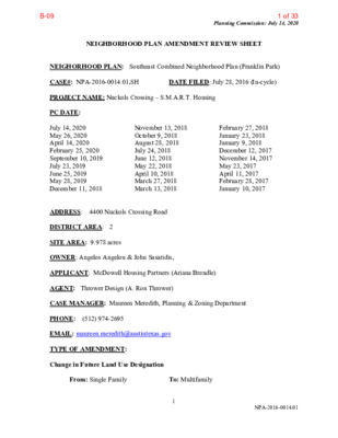
Planning Commission: July 14, 2020 NEIGHBORHOOD PLAN AMENDMENT REVIEW SHEET DATE FILED: July 28, 2016 (In-cycle) NEIGHORHOOD PLAN: Southeast Combined Neighborhood Plan (Franklin Park) CASE#: NPA-2016-0014.01.SH PROJECT NAME: Nuckols Crossing – S.M.A.R.T. Housing PC DATE: July 14, 2020 May 26, 2020 April 14, 2020 February 25, 2020 September 10, 2019 July 23, 2019 June 25, 2019 May 28, 2019 December 11, 2018 ADDRESS: 4400 Nuckols Crossing Road DISTRICT AREA: 2 SITE AREA: 9.978 acres OWNER: Angelos Angelou & John Sasaridis, February 27, 2018 January 23, 2018 January 9, 2018 December 12, 2017 November 14, 2017 May 23, 2017 April 11, 2017 February 28, 2017 January 10, 2017 November 13, 2018 October 9, 2018 August 28, 2018 July 24, 2018 June 12, 2018 May 22, 2018 April 10, 2018 March 27, 2018 March 13, 2018 APPLICANT: McDowell Housing Partners (Ariana Brendle) AGENT: Thrower Design (A. Ron Thrower) CASE MANAGER: Maureen Meredith, Planning & Zoning Department PHONE: (512) 974-2695 EMAIL: maureen.meredith@austintexas.gov TYPE OF AMENDMENT: Change in Future Land Use Designation From: Single Family To: Multifamily 1 NPA-2016-0014.01 1 of 33B-09 Planning Commission: July 14, 2020 (Application was revised on February 13, 2017. Original FLUM request was for Single Family, Multifamily and Recreation/Open Space to Multifamily and Recreation/Open Space) Base District Zoning Change Related Zoning Case: C14-2017-0010.SH From: SF-2-NP To: MF-4-NP (as amended on February 10, 2020) NEIGHBORHOOD PLAN ADOPTION DATE: October 10, 2002 PLANNING COMMISSION RECOMMENDATION: July 14, 2020 – (pending) May 26, 2020 – Postponed to July 14, 2020 at the request of Staff on the consent agenda. [C. Hempel – 1st; R. Schneider – 2nd] Vote: 12-0 [C. Llanes Pulido not present for the passage of the consent agenda]. April 14, 2020 – Postponed to May 26, 2020 at the request of Staff on the consent agenda. [R. Schneider – 1st; C. Kenny – 2nd] Vote: 12-0 [C. Llanes Pulido absent]. February 25, 2020 – Postponed to April 14, 2020 at the request of Staff on the consent agenda. [R. Schneider -1st; C. Kenny – 2nd] Vote: 12-0-1 [J. Shieh absent]. September 10, 2019- Approved for indefinite postponement request by Staff on the consent agenda. [J. Thompson – 1st; J. Shieh – 2nd] Vote: 10-0 [R. Schneider and P. Seeger absent. T. Shaw no present for the passage of the consent agenda]. July 23, 2019 – Postponed to September 10, 2019 at the request of Staff was approved on the consent agenda. [P. Seeger – 1st; A. Azhar – 2nd] Vote: 10-0 [ R. Schneider, J. Thompson and Shaw absent]. June 25, 2019 – Postponed to July 23, 2019 on the consent agenda at the request of Staff. [A. Azhar – 1st; C. Kenny – 2nd’ Vote: 11-0 [J. Shieh absent]. May 28, 2019 – Postponed to June 25, 2019 on the consent agenda at the request of Staff. [J. Shieh – 1st; P. Howard – 2nd] Vote: 12- 0 [K. McGraw absent]. December 11, 2018- Postponed indefinitely on the consent agenda at the request of Staff. [K. McGraw – 1st; F. Kazi – 2nd] Vote: 11-0 [Y. Flores and C. Kenny absent]. November 13, 2018 – Postponed to December 11, 2018 on the consent agenda at the request of Staff. [P. Seeger – 1st; R. Schneider – 2nd] Vote: 12 – 0. [A. De Hoyos Hart absent]. 2 NPA-2015-0014.01.SH 2 of 33B-09 Planning Commission: July 14, 2020 October 9, 2018 – Postponed to November 13, 2018 at the request of Staff on the consent agenda. [P. Seeger – 1st; K. McGraw – 2nd] Vote: 10 – 0 [J. Shieh and T. Witte absent. One vacancy] August 28, 2018 - Postponed to October 9, 2018 at the request of Staff on the consent agenda. [J. Schissler – 1st; C. Kenny – 2nd] Vote: 12-0 [One vacancy]. July 24, 2018 – Postponed to August 28, 2018 at the request of Staff on the consent agenda. [G. Anderson – 1st; A. De Hoyos Hart – 2nd] Vote: 9-0 [ F. Kazi, J. Shieh, J. Thompson and T. White absent]. June 12, 2018 – Postponed to July 24, 2018 at the request of Staff on the consent agenda. [J. Schissler – 1st; J. Shieh – 2nd] 12-0 [C. Kenny absent]. May 22, 2018 – Planning Commission postponed to June 12, 2018 on the consent agenda. [P. Seeger – 1st; J. Schissler – 2nd] Vote: 13-0 [K. McGraw noted nay on Item C-11]. April 10, 2018 – After discussion, postponed to May 22, 2018 leaving the public hearing open. [G. Anderson-1st; J. Schissler – 2nd] Vote:7- 4 [T. White and A. De Hoyos Hart absent. P. Seeger, K. McGraw, S. Oliver, T. Shaw voted nay]. March 27, 2018 - Planning Commission postponed to April 10, 2018 on the consent agenda. [G. Anderson- 1st; J. Thompson – 2nd] Vote:12-0 [P. Seeger absent. J. Schissler abstain from Items C-23 & C-24. F. Kazi abstained from Item C-23. K. McGraw voted nay on Item C- 19}. March 13, 2018 – Postponed on the consent agenda at the request of Staff to the March 27, 2018 hearing. [T. White – 1st; P. Seeger – 2nd] Vote: 8-0 [T. Nuckols, A. De Hoyos Hart, J. Shieh, and J. Thompson absent]. February 27, 2018- Postponed on the consent agenda at the request of Staff to the March 13, 2018 hearing. [J. Schissler – 1st; J. Shieh – 2nd] Vote: 12-0 [J. Thompson absent]. January 23, 2018 – Postponed on the consent agenda at the request of Staff to the February 27, 2018 hearing. [P. Seeger – 1st; G. Anderson – 2nd] Vote: 10-0 [F. Kazi arrived after the consent agenda vote. A. De Hoyos Hart and J. Schissler absent]. January 9, 2018 – Postponed on the consent agenda at the request of Staff to the January 23, 2018 hearing. [P. Seeger- 1st; A. De Hoyos Hart – 2nd] Vote: 11-0 [F. Kazi off the dais. T. Nuckols absent]. December 12, 2017 – Postponed on the consent agenda at the request of Staff to the January 9, 2018 hearing. [J. Shieh – 1st; P. Seeger – 2nd] Vote: 12-0 [A. De Hoyos Hart absent]. 3 NPA-2015-0014.01.SH 3 of 33B-09 Planning Commission: July 14, 2020 November 14, 2017 – Postponed to December 12, 2017 at the request by Staff on the consent agenda. [J. Shieh – 1st; T. White – 2nd] Vote: 13-0. [J. Schissler recused from item C-21. N. Zaragoza recused from item C-16]. May 23, 2017- Approved Applicant’s request for an indefinite postponement on the consent agenda. [P. Seeger- 1st; N. Zaragoza – 2nd] Vote: 8-0 [Chair Kazi absent for consent agenda. Commissioners De Hoyos Hart, J. Schissler, J. Thompson and T. White absent]. April 11, 2017- Postponed on the consent agenda at the request of the Applicant to May 23, 2017. [N. Zaragoza – 1st; P. Seeger – 2nd] Vote: 11-0 [S. Oliver and T. White absent]. February 28, 2017 – Postponed on the consent agenda at the request of the Applicant to April 11, 2017. [P. Seeger – 1st; A. DeHoyos – 2nd] Vote: 11-0 [Commissioners Thompson and White absent]. January 10, 2017 – Postponed on the consent agenda at the request of the Applicant to February 28, 2017. [N. Zaragoza- 1st; F. Kazi – 2nd] Vote: 13-0 STAFF RECOMMENDATION: Recommended. BASIS FOR STAFF’S RECOMMENDATION (Revised on June 29, 2020).: Staff recommends the applicant’s request for multifamily land use because the land use is appropriate in this location where multifamily already exists and the request will provide additional housing choices for the area. Below are sections of the Southeast Combined Plan document that supports the applicant’s request. Land Use Goals Goal 1 Provide a balance of mixed-income housing options that will contribute to the neighborhood’s vitality and stability and encourage the development of land uses that promote the interaction between residential and non-residential uses. Objective 1.1 Explore opportunities for the development of a variety of housing and commercial options. Action Item 2 Rezone residentially-used properties inappropriately zoned for their current use to provide a stable supply of housing options. (Implementer: NPZD) Action Item 3 Support the rezoning of undeveloped land in residential areas to make future development compatible with the prevailing residential land use scheme. (Implementer: NPZD) TRANSPORTATION 4 NPA-2015-0014.01.SH 4 of 33B-09 Planning Commission: July 14, 2020 LAND USE DESCRIPTIONS EXISTING LAND USE ON THE PROPERTY Single family - Detached or two family residential uses at typical urban and/or suburban densities Purpose 1. Preserve the land use pattern and future viability of existing neighborhoods; 2. Encourage new infill development that continues existing neighborhood patterns of development; and 3. Protect residential neighborhoods from incompatible business or industry and the loss of existing housing. Application 1. Existing single established neighborhoods; and 2. May include small lot options (Cottage, Urban Home, Small Lot Single Family) and two family residential options (Duplex, Secondary Apartment, Single Family Attached, Two Family Residential) in areas considered appropriate for this type of infill development. ‐ family areas should generally be designated as single family to preserve ‐ ‐ 5 NPA-2015-0014.01.SH 5 of 33B-09 Planning Commission: July 14, 2020 family areas should generally be designated as single family to preserve Purpose 1. Preserve the land use pattern and future viability of existing neighborhoods; 2. Encourage new infill development that continues existing neighborhood patterns of development; and 3. Protect residential neighborhoods from incompatible business or industry and the loss of existing housing. Application 1. Existing single established neighborhoods; and 2. May include small lot options (Cottage, Urban Home, Small Lot Single Family) and family residential options (Duplex, Secondary Apartment, Single Family Attached, two Two Family Residential) in areas considered appropriate for this type of infill development. ‐ PROPOSED LAND USE ON THE PROPERTY Multifamily Higher-density housing with 3 or more units on one lot Purpose 1. Preserve existing multifamily and affordable housing; 2. Maintain and create affordable, safe, and well-managed rental housing; and 3. Make it possible for existing residents, both homeowners and renters, to continue to live in ‐ ‐ their neighborhoods. 4. Applied to existing or proposed mobile home parks. Application 1. Existing apartments should be designated as multifamily unless designated as mixed use; 2. Existing multifamily-zoned land should not be recommended for a less intense land use category, unless based on sound planning principles; and 3. Changing other land uses to multifamily should be encouraged on a case-by-case basis. IMAGINE AUSTIN PLANNING PRINCIPLES 1. Create complete neighborhoods across Austin that provide a mix of housing types to suit a variety of household needs and incomes, offer a variety of transportation options, and 6 NPA-2015-0014.01.SH 6 of 33B-09 Planning Commission: July 14, 2020 have easy access to daily needs such as schools, retail, employment, community services, and parks and other recreation options. • The Applicant’s request for multifamily will provide a mix of housing types for the area and the City. 2. Support the development of compact and connected activity centers and corridors that are well-served by public transit and designed to promote walking and bicycling as a way of reducing household expenditures for housing and transportation. • The property is located within the southeast edge of the Dove Springs Neighborhood Activity Center as Identified on the Imagine Austin Growth Concept Map, but is not located on an Activity Corridor. 3. Protect neighborhood character by ensuring context-sensitive development and directing more intensive development to activity centers and corridors, redevelopment, and infill sites. • The property is located within the southeast edge of the Dove Springs Neighborhood node as identified on the Imagine Austin Growth Concept Map, and south of the McKinney Jobs Center. 4. Expand the number and variety of housing choices throughout Austin to meet the financial and lifestyle needs of our diverse population. • The applicant proposes to build apartment dwelling units, which would provide housing choices for the planning area and the city. 5. Ensure harmonious transitions between adjacent land uses and development intensities. • To the northwest and south of the property are with apartments with multifamily zoning and land use on the future land use map. 6. Protect Austin’s natural resources and environmental systems by limiting land use and transportation development over environmentally sensitive areas and preserve open space and protect the function of the resource. • The property is located in the Desired Development Zone. Please see the zoning case report C14-2017-0010.SH for more information. 7. Integrate and expand green infrastructure—preserves and parks, community gardens, trails, stream corridors, green streets, greenways, and the trails system—into the urban environment and transportation network. 8. Protect, preserve and promote historically and culturally significant areas. • Not applicable. • Not applicable. 9. Encourage active and healthy lifestyles by promoting walking and biking, healthy food choices, access to affordable healthcare, and to recreational opportunities. 7 NPA-2015-0014.01.SH 7 of 33B-09 Planning Commission: July 14, 2020 10. Expand the economic base, create job opportunities, and promote education to support a 11. Sustain and grow Austin’s live music, festivals, theater, film, digital media, and new • Not applicable. strong and adaptable workforce. • Not applicable. creative art forms. • Not applicable. 12. Provide public facilities and services that reduce greenhouse gas emissions, decrease water and energy usage, increase waste diversion, ensure the health and safety of the public, and support compact, connected, and complete communities. • Not applicable. IMAGINE AUSTIN GROWTH CONCEPT MAP Definitions Neighborhood Centers - The smallest and least intense of the three mixed-use centers are neighborhood centers. As with the regional and town centers, neighborhood centers are walkable, bikable, and supported by transit. The greatest density of people and activities in neighborhood centers will likely be concentrated on several blocks or around one or two intersections. However, depending on localized conditions, different neighborhood centers can be very different places. If a neighborhood center is designated on an existing commercial area, such as a shopping center or mall, it could represent redevelopment or the addition of housing. A new neighborhood center may be focused on a dense, mixed-use core surrounded by a mix of housing. In other instances, new or redevelopment may occur incrementally and concentrate people and activities along several blocks or around one or two intersections. Neighborhood centers will be more locally focused than either a regional or a town center. Businesses and services—grocery and department stores, doctors and dentists, shops, branch libraries, dry cleaners, hair salons, schools, restaurants, and other small and local businesses—will generally serve the center and surrounding neighborhoods. Town Centers - Although less intense than regional centers, town centers are also where many people will live and work. Town centers will have large and small employers, although fewer than in regional centers. These employers will have regional customer and employee bases, and provide goods and services for the center as well as the surrounding areas. The buildings found in a town center will range in size from one-to three-story houses, duplexes, townhouses, and rowhouses, to low-to midrise apartments, mixed use buildings, and office buildings. These centers will also be important hubs in the transit system. Job Centers - Job centers accommodate those businesses not well-suited for residential or environmentally- sensitive areas. These centers take advantage of existing transportation 8 NPA-2015-0014.01.SH 8 of 33B-09 Planning Commission: July 14, 2020 infrastructure such as arterial roadways, freeways, or the Austin-Bergstrom International airport. Job centers will mostly contain office parks, manufacturing, warehouses, logistics, and other businesses with similar demands and operating characteristics. They should nevertheless become more pedestrian and bicycle friendly, in part by better accommodating services for the people who work in those centers. While many of these centers are currently best served by car, the growth Concept map offers transportation choices such as light rail and bus rapid transit to increase commuter options. Corridors - Activity corridors have a dual nature. They are the connections that link activity centers and other key destinations to one another and allow people to travel throughout the city and region by bicycle, transit, or automobile. Corridors are also characterized by a variety of activities and types of buildings located along the roadway — shopping, restaurants and cafés, parks, schools, single-family houses, apartments, public buildings, houses of worship, mixed-use buildings, and offices. Along many corridors, there will be both large and small redevelopment sites. These redevelopment opportunities may be continuous along stretches of the corridor. There may also be a series of small neighborhood centers, connected by the roadway. Other corridors may have fewer redevelopment opportunities, but already have a mixture of uses, and could provide critical transportation connections. As a corridor evolves, sites that do not redevelop may transition from one use to another, such as a service station becoming a restaurant or a large retail space being divided into several storefronts. To improve mobility along an activity corridor, new and redevelopment should reduce per capita car use and increase walking, bicycling, and transit use. Intensity of land use should correspond to the availability of quality transit, public space, and walkable destinations. Site design should use building arrangement and open space to reduce walking distance to transit and destinations, achieve safety and comfort, and draw people outdoors. 9 NPA-2015-0014.01.SH 9 of 33B-09 Proximity to Imagine Austin Activity Corridors and Centers Planning Commission: July 14, 2020 10 NPA-2015-0014.01.SH 10 of 33B-09 Planning Commission: July 14, 2020 Park Facilities in the Area 11 NPA-2015-0014.01.SH 11 of 33B-09 Planning Commission: July 14, 2020 Capital Metro Bus Routes in the Area BACKGROUND: The application was filed July 28, 2016, which is in-cycle for neighborhood planning areas located on the east side of I.H.-35. The application that was originally filed in July 2016 contained approximately 27.413 acres, but the application was revised on September 28, 2018 to reduce the area to a 9.978 acre tract that is zoned SF-2-NP with the existing future land use of Single Family land use. The proposed land use is Multifamily. The plan amendment application has an associated zoning case, C14-2017-0010.SH, which the applicant is requesting a change in zoning from SF-2-NP to MF-4-NP to build apartments. PUBLIC MEETINGS: The ordinance-required community meeting was held on February 13, 2017. Approximately 560 meeting notices were mailed to property owners and utility account holders who live within 500 feet of the property, in addition to the neighborhood and environmental groups who have requested notification for the area. 12 NPA-2015-0014.01.SH 12 of 33B-09 Planning Commission: July 14, 2020 Note: Since this community meeting was conducted, the applicants’ amended their plan amendment and zoning change applications to request Multifamily land use and MF-4-NP zoning. Please see the associated zoning case, C14-2017-0010.SH, for updated proposed development information. After city staff gave an overview of the applicant’s plan amendment and zoning request and an overview of the process, the person renting the property made the following presentation. Agents: Ron Thrower and Victoria Haase with Thrower Design Property Owners: Angelos Angelou and John Sasaridis City Planner: Kathleen Fox, Senior Planner Audience Attendees: 39 Ana Aquirre, the Chair of the Southeast Combined Neighborhood Plan Contact Team asked everyone to introduce themselves to the room. Kathleen Fox, the City of Austin’s project manager for this Neighborhood Plan Amendment case explained that applicants were requesting a change to the Future Lane Use Map for the Southeast Combined Neighborhood Plan from Single Family to Multifamily to build a multifamily project. The applicant had also amended their rezoning and neighborhood plan amendment case that morning and were removing the MF-2 portion from the case and asking to rezone the RR zone, to zone MF-3. Ron Thrower gave presentation on the proposed project, which called for: • Rezoning approximately 27 acres of the property from RR and SF-2 to MF-3. Mr. Thrower acknowledged the expansion of the boundaries of the flood plain on the property, which had grown over the years. His stated that his clients would also honor the boundaries of the floodplain. The proposal called for the construction of 308 multifamily units, at a density of approximately 11 units per acre, although zone MF-3 would allow up to a density of 36 units per acre. The project concept called for attached and detached one and two bedroom units, which would be two stories tall with garages. No variances were being requested for in this project. He highlighted how this project was near a CapMetro stop; an elementary school; and commercial uses. Citizen Question/Comment: Would access and associated road improvements being only off Nuckols Crossing Road? Thrower: Yes Citizen Question/Comment: How can Nuckols Crossing Road sustain additional traffic, especially when we have no sidewalks? Do your clients intend to not only improve their frontage along Nuckols Crossing Road with a sidewalk and entranceway but further down Nuckols Crossing Road to mitigate the traffic impact of this project? Thrower: The developer will only improve the frontage along their property according to City regulations. He mentioned that the City of Austin was looking at improving Nuckols Crossing Road in the near future. Citizen Question/Comment: Why even ask for Multifamily zoning on the wetlands portion of the property? 13 NPA-2015-0014.01.SH 13 of 33B-09 Planning Commission: July 14, 2020 Thrower: There is more flexibility to design the property if everything just under one zone. The wetland area would also not be touched. They are also not going to get rid of the flood plain or ask for any variances to this development. Haase: There are city regulations that prohibit anyone from developing in the floodplain area. They will not be developing in the floodplain. Thrower: He explained that in the past, Zone RR was applied to all property in the flood plain and that flood plains were designated in neighborhood plans as ‘Recreation and Open Space’ but that was not the case anymore. Only public property is supposed to have that land use designation. Citizen Question/Comment: An audience member expressed concern that this new development would push water onto surrounding properties. Thrower: He stated that detention would be provided onsite and that the developer would have to comply with City ordinances regarding water detention. Citizen Question/Comment: How large is the wetland/flood plain area on the site? Thrower: Approximately 5 acres. Citizen Question/Comment: Why is the request to go from MF-2 to MF-3 and not fully using the zoning (entitlements)? Thrower: He explained that they removed the MF-2 portion from this request and would only be asking for MF-3 zoning on the SF-2 and RR zoned portions of the property. Citizen Question/Comment: Why zone the property to MF-3 instead of MF-2 if they only wanted 11 units per acre? They stated that 36 units per acre was too much. Thrower: He said his client might be receptive to agreeing to a conditional overlay to limit the number of units per acre for this project. Also, the 11 units an acre did not include the 5 acres in the flood plain, which meant the buildable portion of the site would have more than 11 units per acre. Citizen Question/Comment: They are serious concerns with traffic access going on and off this property due to the blind spot along Nuckols Crossing Road; the amount of rush hour traffic; and getting out onto Nuckols Crossing Road from private drives. Traffic issues are difficult now and will only worsen with traffic coming from an additional 300 plus residential units. They asked the developer to include a dedicated lane going to and from this development so that vehicles would exit/enter directly onto Nuckols Crossing Road. Citizen Question/Comment: Would the MF-3 zoning also cover the flood plain area? Thrower: They are seeking MF-3 zoning for the entire site for design purposes. The flood plain area would not have any buildings on it but would be included in the overall density of the site of 11 units per acre (meaning the flood plain area would have no units on it while the buildable portion would have more than 11 units per acre to make up for the 5 acres lost in the floodplain.) 14 NPA-2015-0014.01.SH 14 of 33B-09 Planning Commission: July 14, 2020 Citizen Question/Comment: A woman explained that she inherited property, which was due north of the subject property and was one of the most beautiful properties in Austin. The area is a nature reserve and she stated that people needed to downsize, and listen to the animals. She said that this town needs something for the kids and a park, and that there are already problems with water runoff in the area. She said money talks but we have voices. It’s (the project) too much. Citizen Question/Comment: Will there be a second exit to allow emergency vehicles to get onto the property besides Nuckols Crossing Road? Thrower: There will be no second exit. Citizen Question/Comment: What are the proposed types of units on the property? Angelou: Approximately 30 percent of the units will be 1 bedroom, 60 percent would be 2 bedroom units, and maybe there will be some three bedroom units. The market rate for this area was $650 to $850 for one bedroom and $950 to $1100 for 2 bedrooms. The asking price for an apartment in this area averaged $978 per unit according to the American Community Survey. Citizen Question/Comment: Where did you get this data? Angelou: He stated from a city website and looked it up and it was from the American Community Survey, which is data supplied by the U.S. Census. Citizen Question/Comment: Would you be willing to put in writing that the detention would be onsite? Thrower: He said they could do that. Citizen Question/Comment: What about the issue of affordable housing; is the developer providing any affordable units? That same person reiterated that they wanted to see a certain percentage of the units be designated as affordable units. Thrower: He stated that they had not discussed an affordable housing component and that many neighborhoods were against affordable housing. He also stated that he could talk more about affordable housing with the neighborhood at the March 13th neighborhood meeting. Citizen Question/Comment: There is a huge demand three bedroom apartment units and a lot of pressure coming from households in the 30 to 50 MFI. They hoped the developer would consider offering more three bedroom units and consider household affordability for this income bracket and larger families. Citizen Question/Comment: What is the price point for these units? Angelou: He stated they were still analyzing this issue. He explained that he wanted to build high quality development in this area of Austin and go beyond the minimum. Citizen Question/Comment: There is a push not to develop more than 2 bedroom units but now there is a push to develop more units per acre. 15 NPA-2015-0014.01.SH 15 of 33B-09 Planning Commission: July 14, 2020 Citizen Question/Comment: Will the detention pond be located in the wetlands area? Thrower: No. Citizen Question/Comment: Person stated that they hoped they could make this project both beautiful and include affordability (component). Citizen Question/Comment: How is the project going to be laid out? Where are you going to put the detention pond? We want to see the layout of the project. Angelou: He stated they had not picked a developer yet or completed a site plan. Citizen Question/Comment: What are the amenities you are going to have for the children? Angelou: He stated they had not decided on what amenities to offer at this time. Citizen Question/Comment: They discussed the beauty of the wetlands. They wanted to know if a conditional overlay would run with the property unless the zone changed. They said they were concerned the developer/owner will get rid of the conditional overlay or change the zoning in the future and wanted a restricted covenant that would run with the land. This man then went over the history of the parcel, the existing apartment complex, a land swap, and switching the zoning from multifamily for this property to enable the existing apartment complex to be rezoned from single family to multifamily. Angelou: He stated that an environmental feature on his property triggered the restricted covenant. Citizen Question/Comment: An audience member asked City staff if they had a staff recommendation on this case and to share it with them. Fox: Ms. Fox explained that the planning department had not discussed this case yet or developed a group recommendation as of yet. The staff recommendation would be a group decision based on the policies taken from the neighborhood plan, and the merits of the case. Citizen Question/Comment: How many trees will be cut down for this project? Thrower: They didn’t know right now. Angelou: He stated that most of the trees on the property were cedar trees and small oaks. CITY COUNCIL DATES: December 14, 2017 February 1, 2018 ACTION: Postponed to the February 1, 2018 at the request of staff. [D. Garza – 1st; E. Troxclair – 2nd] Vote: 11-0 ACTION: Postponed to March 8, 2018 at the request of staff. [O. Houston – 1st; P. Renteria – 2nd] Vote: 11-0. 16 NPA-2015-0014.01.SH 16 of 33B-09 March 8, 2018 April 12, 2018 May 24, 2018 June 28, 2018 August 23, 2018 October 18, 2018 December 13, 2018 June 20, 2019 August 8, 2019 October 3, 2019 March 26, 2020 May 21, 2020 Planning Commission: July 14, 2020 ACTION: Postponed to April 12, 2018 at the request of staff. [S. Adler – 1st; D. Garza – 2nd] Vote: 11-0. ACTION: Postponed to May 24, 2018 at the request of staff. [L. Pool – 1st; A. Kitchen – 2nd] Vote: 6-0 [G. Casar off the dais. Mayor Adler, Mayor Pro Tem Tovo, D. Garza and E. Troxclair absent]. ACTION: Postponed to June 28, 2018 at the request of staff. [O. Houston – 1st; D. Garza – 2nd] Vote 10-0 [E. Troxclair absent]. ACTION: Postponed to August 23, 2018 at the request of staff. [E. Troxclair – 1st; D. Garza – 2nd] Vote: 11-0. ACTION: Postponed to October 18, 2018 at the request of staff. [G. Casar – 1st; P. Renteria – 2nd] Vote: 11-0. ACTION: Postponed to December 13, 2018 at the request of staff. [D. Garza – 1st; O. Houston – 2nd] Vote: 10-0 [L. Pool absent]. ACTION: Indefinitely postponed at the request of staff. [A. Alter – 1st; G. Casar – 2nd] Vote: 9-0 [Mayor Adler off the dais. P. Renteria absent]. ACTION: Postponed to August 8, 2019 at the request of staff. ACTION: Approved a Postponement request by Staff to October 3, 2019 (11-0). ACTION: Approved an Indefinite Postponement request by Staff (10-0, Council Member Harper-Madison was off the dais). ACTION: Approved a Postponement request by Staff to May 21, 2020 (11-0). ACTION: Approved a Postponement request by 17 NPA-2015-0014.01.SH 17 of 33B-09 Planning Commission: July 14, 2020 Staff to June 11, 2020 (11-0). ACTION: Approved a Postponement request by Staff to July 30, 2020 (11-0). ACTION: (Pending) June 11, 2020 July 30, 3030 18 NPA-2015-0014.01.SH 18 of 33B-09 Summary Letter Submitted by the Applicant Planning Commission: July 14, 2020 19 NPA-2015-0014.01.SH 19 of 33B-09 Planning Commission: July 14, 2020 20 NPA-2015-0014.01.SH 20 of 33B-09 Letter of Recommendation from the Southeast Combined Neighborhood Plan Contact Team Planning Commission: July 14, 2020 21 NPA-2015-0014.01.SH 21 of 33B-09 Neighborhood Assn. Letter – Updated July 7, 2020 Planning Commission: July 14, 2020 22 NPA-2015-0014.01.SH 22 of 33B-09 Planning Commission: July 14, 2020 23 NPA-2015-0014.01.SH 23 of 33B-09 Planning Commission: July 14, 2020 Site 24 NPA-2015-0014.01.SH 24 of 33B-09 Planning Commission: July 14, 2020 25 NPA-2015-0014.01.SH 25 of 33B-09 Planning Commission: July 14, 2020 26 NPA-2015-0014.01.SH 26 of 33B-09 Planning Commission: July 14, 2020 27 NPA-2015-0014.01.SH 27 of 33B-09 Planning Commission: July 14, 2020 28 NPA-2015-0014.01.SH 28 of 33B-09 Planning Commission: July 14, 2020 29 NPA-2015-0014.01.SH 29 of 33B-09 Planning Commission: July 14, 2020 30 NPA-2015-0014.01.SH 30 of 33B-09 Planning Commission: July 14, 2020 31 NPA-2015-0014.01.SH 31 of 33B-09 Planning Commission: July 14, 2020 32 NPA-2015-0014.01.SH 32 of 33B-09 Planning Commission: July 14, 2020 33 NPA-2015-0014.01.SH 33 of 33B-09