B-15 (C8-2020-0038.0A - Charro Estates; 5-Mi ETJ) — original pdf
Backup
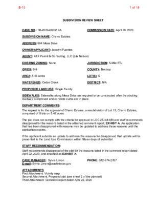
SUBDIVISION REVIEW SHEET CASE NO.: C8-2020-00038.0A COMMISSION DATE: April 28, 2020 SUBDIVISION NAME: Charro Estates ADDRESS: 694 Mesa Drive OWNER/APPLICANT: Jocelyn Fuentes AGENT: ATX Permit & Consulting, LLC (Lila Nelson) EXISTING ZONING: None JURISDICTION: 5-Mile ETJ GRIDS: S-9 COUNTY: Bastrop AREA: 5.46 acres LOT(S): 5 WATERSHED: Cedar Creek DISTRICT: N/A PROPOSED LAND USE: Single Family SIDEWALKS: Sidewalks along Mesa Drive are required to be constructed after the abutting roadway is improved and concrete curbs are in place. DEPARTMENT COMMENTS: The request is for the approval of Charro Estates, a resubdivision of Lot 15, Charro Estates, comprised of 5 lots on 5.46 acres. The plat does not comply with the criteria for approval in LDC 25-4-84(B) and staff recommends disapproval for the reasons listed in the attached comment report, EXHIBIT A. An application that has been disapproved with reasons may be updated to address those reasons until the application expires. If the applicant submits an update to address the reasons for disapproval, that update will be presented to the Land Use Commission within fifteen days of submittal. STAFF RECOMMENDATION: Staff recommends disapproval of the plat for the reasons listed in the comment report dated April 22, 2020, and attached as EXHIBIT A. CASE MANAGER: Sylvia Limon E-mail: Sylvia.Limon@austintexas.gov PHONE: 512-974-2767 ATTACHMENTS First Attachment: Vicinity map Second Attachment: Proposed plat (see sheet 2 of the plan set) Third Attachment: Comment report dated April 22, 2020 1 of 18B-15 CITY OF AUSTIN –DEVELOPMENT SERVICES DEPARTMENT SUBDIVISION APPLICATION – MASTER COMMENT REPORT 694 MESA DR March 30, 2020 UPDATE: PHONE #: U0 512-974-2767 C8-2020-0038.0A 00 CASE NUMBER: REVISION #: CASE MANAGER: Sylvia Limon PROJECT NAME: Charro Estates (W/R C8-2019-0031.0A) LOCATION: SUBMITTAL DATE: REPORT DUE DATE: April 24, 2020 FINAL REPORT DATE: April 22, 2020 STAFF REPORT: This report includes all staff comments received to date concerning your most recent subdivision application submittal. The comments may include requirements, recommendations, or information. The requirements in this report must be addressed by an updated submittal. The subdivision application will be approved when all requirements from each review discipline have been addressed. If you have any questions, concerns or if you require additional information about this report, please contact your case manager at the phone number listed above or by using the contact information listed for each reviewer in this report. Any change to the plan/plat shall not cause noncompliance with any applicable code or criteria. In addition, any change to the plat may trigger new comments. UPDATE DEADLINE INFORMATION (LDC 25-4-56; 25-4-82): All comments must be addressed by filing an updated submittal prior to the update deadline of June 29, 2020. Otherwise, the application will expire. If this date falls on a weekend or City of Austin holiday, the next City of Austin workday will be the deadline. Extension of Review Period, Extension of Update Deadline and Tolling of Application Period do not apply to applications for preliminary plan, plat or subdivision construction plans (LDC 25-1-88; 25-1-89; 25-1- 90). UPDATE SUBMITTAL INSTRUCTIONS (LDC 25-1-83): 1. Applicants must make an appointment with Intake Staff (974-1770) in order to submit an update. 2. Your update must include the following items: a. This report b. The revised plat/plan in pdf format c. A letter that addresses each comment in the master comment report 3. Updates must be submitted on an approved submittal date, between the hours of 8:30 am and 4:00 pm. Refer to the submittal calendar for a list of approved submittal dates. REVIEWERS: Planner 1: Cindy Edmond PARD / Planning & Design: Thomas Rowlinson Drainage Engineering: David Marquez Subdivision: Sylvia Limon Water Quality: David Marquez 2 of 18B-15 Electric Review - Andrea Katz - 512-322-6957 Cleared. Out of Austin Energy service area. 911 Addressing Review - Cathy Winfrey - 512-974-2398 AD1: This plat review is cleared; however, any changes to street names, street name labels, or street layouts will require a new review. NOTE: This proposed Subdivision is located inside Bastrop County. Please note that any address assignments to resulting lots or changes to existing addresses will be enacted by Bastrop County 911 Addressing. ATD Engineering Review - Amber Mitchell - 512-974-5646 No comment. Drainage Engineering Review - David Marquez - 512-974-3389 Release of this application does not constitute a verification of all data, information, and calculations supplied by the applicant. The engineer of record is solely responsible for the completeness, accuracy, and adequacy of his/her submittal, whether or not the application is reviewed for code compliance by city engineers. DE1. Construction plans, or an approved site plan prior to the plat, will be required for the proposed construction if the proposed construction does not meet LDC 25-5-2. If construction plans are to be proposed, the case number will need to be changed to .1A. DE2. Per the fiscal policy ordinance, the pond and its grading associated for compliance will need to be included in the fiscal estimate. DE3. To demonstrate compliance with DCM 1.2.2 for no adverse impact, submit the drainage model and associated exhibits to demonstrate no adverse impact for the proposed pond will be required per DCM section 2. This will include taking Atlas 14 into consideration. The fist link is to our recent code and criteria changes and the second is specifically for Atlas 14. Included in the calculations should be a demonstration of no increase of point discharge which will mean the flows will need to spread to match existing conditions. 1 http://austintexas.gov/cityclerk/postings/land_dev_rules_notices.htm http://www.austintexas.gov/edims/document.cfm?id=332437 DE4. Per DCM 1.2.oA drainage easement with required maintenance will be required for the water quality and detention pond. Environmental Review - Jonathan Garner - 512-974-1665 EV 1. Erosion and sedimentation control fiscal surety is not required for a Final Plat application without a Preliminary Plan. Remove this amount from the Fiscal Estimates worksheet. 3 of 18B-15 PARD / Planning & Design Review - Thomas Rowlinson - 512-974-9372 UPDATE 0 (W/R) PR 1: The parkland dedication and park development fee is required per City Code §25-1-601 and must be paid before the subdivision may be approved (low density fee for a project with less than 6 dwelling units per acre). However, no parkland fee will be collected for the existing residence, so the fee for 4 units is required at this time. Bastrop County Appraisal District only shows one residence. Site plan in application only shows one residence. Any increase in units allowed by subdivision must satisfy parkland dedication at subdivision. The park fee bills have now been issued in AMANDA. The person named as an “Applicant” may pay online at Austin Build + Connect. The fee can be made in one payment though there are two bills. Email the PARD reviewer at thomas.rowlinson@austintexas.gov to request the bill numbers. When payment has been made, email the receipt to this reviewer to clear this comment. PR 2: Update note 11 on the plat: A fee-in-lieu of parkland dedication and park development has been paid for 4 residences. No fee was charged for the existing residence Subdivision Review - Sylvia Limon - 512-974-2767 SR 1. Add the Case # C8-2020-0038.0A, in the bottom right hand corner of each sheet. [LDC 25-1-83] SR 2. Provide a subdivision plat where each sheet is 18” x 24”; these sheets should be separate from any construction plan sets. [LDC 25-1-83] SR 3. If the drainage easement is being created with the plat, be sure show survey boundary information for the boundary of the easement. It appears there are not corresponding measurements for all of the boundary lines of the easement. [LDC 25-1-83] SR 4. Remove plat note number 2. This note is not applicable since City of Austin Water Utility will not be servicing this subdivision. [LDC 25-1-83] SR 5. FYI: Submit any legal documents to the reviewer requiring them as soon as possible. The legal review may take an extended time and could delay your project. [LDC 25-1-83] SR 6. Revise the City of Austin Commission approval block to appear as follows on the plat [LDC 25-1-83]: ACCEPTED AND AUTHORIZED FOR RECORD BY THE LANDUSE COMMISSION OF THE CITY OF AUSTIN, TEXAS, THIS, THE ______DAY OF ___________________20__. ___________________________ _________________________ _____________________, CHAIR _______________________, SECRETARY SR 7. Show signatures of owner(s), notary public(s) with appropriate seals and dates. Print names under signatures with addresses. These items must be complete on the original mylar prior to approval. [LDC 25-1-83] SR 8. All other signatures/seals will be needed on the final plat mylar prior to the Land Use Commission hearing. These include the surveyor, engineer, Aqua Water Supply, On-Site Sewage. [LDC 25-1- 83] 4 of 18B-15 SR 9. (FYI) Original (crimped) tax certificates showing all taxes having been paid for the past year must be provided at the time the plat is cleared for approval. Bastrop County will NOT record the plat without them. [LDC 25-1-83] SR 10. Recording fees will be calculated after the plat is approved. [LDC 25-1-83] SR 11. Two mylar copies of the plat will be needed after the plat has been cleared for approval and prior to the Land Use Commission hearing. [LDC 25-1-83] SR 12. This plat is required to have action no later than 30 days after the application is accepted. If the plat is determined to not meet all applicable subdivision regulations – the plat will be presented to Land Use Commission for disapproval with reasons. The application will be required to file an update to clear any remaining issues and then re- presented to Land Use Commission for approval. [LDC 25-4-32] SR 13. The following items will be needed to record the plat [LDC 25-1-83]: • Plat containing original signatures, with appropriate seals and dates. The seals must be legible. • Original tax certificate(s) showing all taxes paid for the previous year. • Check for the plat recordation fee and any document to be recorded with the plat. Transportation Planning - Martin Laws - 512-974-6351 TR1. Transportation Planning has no comments. AW Utility Development Services - Bradley Barron - 512-972-0078 WW1. The landowner intends to serve each lot with a connection to Aqua Water Supply Company water utilities and an On-Site Sewage Facility. No Austin Water review is required. WW2. The landowner must obtain plat approval from Bastrop County for on-site sewage facilities. No Austin Water review is required. WW3. Bastrop County must approve the plan for fire protection. Austin Water will not verify fire protection availability. Water Quality Review - David Marquez - 512-974-3389 Release of this application does not constitute a verification of all data, information, and calculations supplied by the applicant. The engineer of record is solely responsible for the completeness, accuracy, and adequacy of his/her submittal, whether or not the application is reviewed for code compliance by city engineers. WQ1. To demonstrate compliance with ECM section 1.6.5.A, submit cross sections and details to demonstrate the proposed pond will be in compliance. WQ2. Per appendix R-2 of ECM, submit an R table that demonstrates the pond is in compliance and sized for ECM standards. If construction plans are to be provided, an R-1 table will be required for the plat. WQ3. Per ECM 1.6.2B2 pertaining to stacked detention, outlet structures are recommended to be on the sedimentation side of the pond to prevent erosion. 5 of 18B-15 WQ4. Demonstrate erosion control per ECM 1.4.0 and ECM 1.6.2B1, a splitter box is typically required. For stacked detention we allow designs to demonstrate that a splitter is not needed if velocity of flows and erosion control are taken into consideration. WQ5. Provide Certification of Compliance 25-1-83 – Applications Related to a Closed Municipal Solid Waste Landfill. The certification form can be found at the following website: http://www.ci.austin.tx.us/watershed/downloads/engineers_cert_form.pdf Site Plan Plumbing - Cory Harmon - 512-974-2882 NO SITE PLAN PLUMBING REVIEW REQUIRED The proposed resubdivision (C8-2020-0038.0A) is outside of the zoning jurisdiction of the City of Austin and will not receive water or wastewater service from Austin Water Utility, therefore the Austin Plumbing Code is not applicable per Chapter 25-1. End of report 6 of 18B-15 CIVIL CONSTRUCTION PLANS 694 MESA DRIVE DEL VALLE, BASTROP COUNTY, TEXAS FEBRUARY 2020 OWNER / DEVELOPER: JOCELYN FUENTES 1908 BOBBYWOODS LN MANCHACA, TX 78652 LEGAL DESCRIPTION: CHARRO ESTATES, LOT 15, 5.460 ACRES SUBDIVISION CASE NO.: C8-2019-0031.0A TABLE OF CONTENTS COVER SHEET & TABLE OF CONTENTS FINAL PLAT SITE PLAN TEMPORARY EROSION CONTROL PLAN TEMPORARY EROSION CONTROL PLAN DETAILS EXISTING DRAINAGE AREA MAP & CALCULATIONS SHEET 1 SHEET 2 SHEET 3 SHEET 4 SHEET 5 SHEET 6 SHEET 7 GRADING PLAN SHEET 8 SHEET 9 WATER QUALITY CONTROL PLAN SHEET 10 WATER QUALITY CONTROL PLAN DETAILS SHEET 11 GENERAL NOTES & DETAILS FULLY-DEVELOPED DRAINAGE AREA MAP & CALCULATIONS GALLEGOS ENGINEERING, INC. SAN ANTONIO, TEXAS www.gallegoseng.com PH: 210.641.0812 7 of 18B-15 0 100 200 300 4 8 0 3 0 0 - F # N O I T A R T S I G E R M R I F , G N I R E E N I G N E S O G E L L A G . C N I 2 1 8 0 . 1 4 6 . 0 1 2 : H P m o c . g n e s o g e l l a g w w w . S A X E T , O I N O T N A N A S T A L P L A N F I 02 11 PLAT IS FOR REFRENCE PURPOSES ONLY AND IS NOT TO SCALE 8 of 18B-15 SITE PLAN CONSERVATION EASEMENT CONSERVATION EASEMENT DRAINAGE EASEMENT DRAINAGE EASEMENT DRAINAGE EASEMENT CONSERVATION EASEMENT 1018 DRAINAGE EASEMENT M E S A D R . 4 8 0 3 0 0 - F # N O I T A R T S I G E R M R I F , G N I R E E N I G N E S O G E L L A G . C N I 2 1 8 0 . 1 4 6 . 0 1 2 : H P m o c . g n e s o g e l l a g w w w . S A X E T , O I N O T N A N A S N A L P E T S I 03 11 9 of 18B-15 TEMPORARY EROSION CONTROL PLAN 1018 4 8 0 3 0 0 - F # N O I T A R T S I G E R M R I F , G N I R E E N I G N E S O G E L L A G . C N I 2 1 8 0 . 1 4 6 . 0 1 2 : H P m o c . g n e s o g e l l a g w w w . S A X E T , O I N O T N A N A S N A L P L O R T N O C N O S O R E Y R A R O P M E T I 04 11 M E S A D R . 10 of 18B-15 TEMPORARY EROSION CONTROL PLAN DETAILS FLOW WOVEN WIRE SHEATHING 600 mm (24'') MIN. ROCK BERM FLOW 2 1 100 mm (4'') CROSS SECTION RB NOTES: PROFILE PLAN VIEW WATERSHED PROTECTION DEPARTMENT RECORD COPY SIGNED BY MORGAN BYARS 8/24/2010 ADOPTED ROCK BERM STANDARD NO. 639S-1 WATERSHED PROTECTION DEPARTMENT STABILIZED CONSTRUCTION ENTRANCE ADOPTED STANDARD NO. 641S-1 WATERSHED PROTECTION DEPARTMENT RECORD COPY SIGNED BY MORGAN BYARS 09/01/2011 ADOPTED STANDARD NO. 642S-1 4 8 0 3 0 0 - F # N O I T A R T S I G E R M R I F , G N I R E E N I G N E S O G E L L A G . C N I 2 1 8 0 . 1 4 6 . 0 1 2 : H P m o c . g n e s o g e l l a g w w w . S A X E T , O I N O T N A N A S N A L P L O R T N O C N O S O R E Y R A R O P M E T I S L I A T E D 05 11 11 of 18B-15 EXISTING DRAINAGE AREA MAP & CALCULATIONS 5 1 2 3 4 M E S A D R . 1018 1 4 8 0 3 0 0 - F # N O I T A R T S I G E R M R I F , G N I R E E N I G N E S O G E L L A G . C N I 2 1 8 0 . 1 4 6 . 0 1 2 : H P m o c . g n e s o g e l l a g w w w . S A X E T , O I N O T N A N A S P A M A E R A E G A N A R D G N T S X E I I I I S N O T A L U C L A C D N A 06 11 12 of 18B-15 GRADING PLAN C C C C C THE LOCATION OF EXISTING UNDERGROUND UTILITIES ARE SHOWN IN AN APPROXIMATE WAY ONLY. THE CONTRACTOR SHALL DETERMINE THE EXACT LOCATION OF ALL EXISTING UTILITIES BEFORE COMMENCING WORK. HE AGREES TO BE FULLY RESPONSIBLE FOR ANY AND ALL DAMAGES WHICH MIGHT OCCUR BY HIS FAILURE TO EXACTLY LOCATE AND PRESERVE ANY AND ALL UNDERGROUND UTILITIES. M E S A D R . 1018 C 4 8 0 3 0 0 - F # N O I T A R T S I G E R M R I F , G N I R E E N I G N E S O G E L L A G . C N I 2 1 8 0 . 1 4 6 . 0 1 2 : H P m o c . g n e s o g e l l a g w w w . S A X E T , O I N O T N A N A S N A L P G N D A R G I 07 11 13 of 18B-15 FULLY-DEVELOPED DRAINAGE AREA MAP & CALCULATIONS 5 1 2 3 4 M E S A D R . 1018 1 4 8 0 3 0 0 - F # N O I T A R T S I G E R M R I F , G N I R E E N I G N E S O G E L L A G . C N I 2 1 8 0 . 1 4 6 . 0 1 2 : H P m o c . g n e s o g e l l a g w w w . S A X E T , O I N O T N A N A S I P A M A E R A E G A N A R D D E P O L E V E D Y L L U F - I S N O T A L U C L A C D N A 08 11 14 of 18B-15 WATER QUALITY CONTROL PLAN 1018 THE LOCATION OF EXISTING UNDERGROUND UTILITIES ARE SHOWN IN AN APPROXIMATE WAY ONLY. THE CONTRACTOR SHALL DETERMINE THE EXACT LOCATION OF ALL EXISTING UTILITIES BEFORE COMMENCING WORK. HE AGREES TO BE FULLY RESPONSIBLE FOR ANY AND ALL DAMAGES WHICH MIGHT OCCUR BY HIS FAILURE TO EXACTLY LOCATE AND PRESERVE ANY AND ALL UNDERGROUND UTILITIES. 4 8 0 3 0 0 - F # N O I T A R T S I G E R M R I F , G N I R E E N I G N E S O G E L L A G . C N I 2 1 8 0 . 1 4 6 . 0 1 2 : H P m o c . g n e s o g e l l a g w w w . S A X E T , O I N O T N A N A S N A L P L O R T N O C Y T I L A U Q R E T A W 09 11 15 of 18B-15 WATER QUALITY CONTROL PLAN DETAILS H MIN. SLOPE 1/4'' PER FT. TOP OF BANK STORM DRAIN D D *IF OUTFALL HEIGHT IS GREATER THAN 6 FT. USE A DROP MANHOLE ) D E D N E M M O C E R ( ' 1 = Y * X A M ' 6 = Y D MITRE CUT PIPE END TO MATCH SLOPE 2 (OR FLATTER) 1 ROCK RIPRAP LAYER THICKNESS = 2D50 D = PIPE DIAMETER D 50= MEDIAN ROCK DIAMETER La = APRON LENGTH Wa = APRON WIDTH Y = OUTFALL HEIGHT CREEK BOTTOM La = 10D 0 5 D 3 FILTER FABRIC OR GRANULAR FILTER K N A B F O P O T D D TOE TRENCH SECTION VIEW CREEK FLOW 3D50 CREEK BOTTOM K N A B F O E O T D D 3 D 5 = a W NOTE: 1. ROCK RIPRAP SHALL BE SOUND MATERIAL AND GRADED PER REQUIREMENTS SPECIFIED IN STANDARD SPECIFICATION ITEM NO. 591S. PLAN VIEW La = 10D 2. ROCK SIZE (D50) AND GRADATION SHALL BE STABLE FOR THE DESIGN HYDRAULIC CONDITIONS AND IN ACCORDANCE WITH THE ECM 1.4.6.D PERMANENT STRUCTURAL PRACTICES, STONE RIPRAP OR OTHER ENGINEERING STANDARD OF PRACTICE FOR SIZING ROCK RIPRAP. ROCK RIPRAP D50 AND FILTER TYPE SHALL BE NOTED ON PLANS. 3. GEOTEXTILE FILTER FABRIC SHALL MEET THE REQUIREMENTS SPECIFIED IN STANDARD SPECIFICATION ITEM NO. 620S. 4. AGGREGATE FOR GRANULAR FILTER SHALL MEET THE REQUIREMENTS SPECIFIED IN STANDARD SPECIFICATION ITEM NO. 403, AGGREGATE SIZE CLASSIFICATION/GRADE, NUMBER OF LAYERS AND LAYER THICKNESS SHOULD BE NOTED ON THE PLANS. *EXTEND ARMOR TO OPPOSITE CREEK BANK FOR CHANNELS LESS THAN 10D IN WIDTH CITY OF AUSTIN WATERSHED PROTECTION DEPARTMENT STORMDRAIN OUTFALL PROTECTION PIPE DISCHARGE ON SLOPE-LOW BANK RECORD COPY SIGNED BY MORGAN BYARS 09/01/2011 ADOPTED THE ARCHITECT/ENGINEER ASSUMES RESPONSIBILITY FOR APPROPRIATE USE OF THIS STANDARD. STANDARD NO. 508S-16 WATERSHED PROTECTION DEPARTMENT STANDARD NO. ADOPTED 1.8 m (6') MIN. STANDARD SYMBOL 0.3 m (1') L= WATERSHED PROTECTION DEPARTMENT LEVEL SPREADER ADOPTED STANDARD NO. 634S-1 4 8 0 3 0 0 - F # N O I T A R T S I G E R M R I F , G N I R E E N I G N E S O G E L L A G . C N I 2 1 8 0 . 1 4 6 . 0 1 2 : H P m o c . g n e s o g e l l a g w w w . S A X E T , O I N O T N A N A S I S L A T E D N A L P L O R T N O C Y T I L A U Q R E T A W 10 11 TRENCH EXCAVATION SAFETY PROTECTION Contractor and/or Contractor's independently retained employee or structural design/geotechnical/safety/equipment consultant, if any, shall review these plans and available geotechnical information and the anticipated installation site(s) within the project work area in order to implement contractor's trench excavation safety protection systems, programs and/or procedures for the project described in the contract documents. The Contractor's implementation of these systems, programs and/or procedures shall provide for adequate trench excavation safety protection that comply with as a minimum, OSHA standards for trench excavations. Specifically, Contractor and/or Contractor's independently retained employee or safety consultant shall implement a trench safety program in accordance with OSHA standards governing the presence and activities of individuals working in and around trench excavation. 16 of 18B-15 GENERAL NOTES AND DETAILS 4 8 0 3 0 0 - F # N O I T A R T S I G E R M R I F , G N I R E E N I G N E S O G E L L A G . C N I 2 1 8 0 . 1 4 6 . 0 1 2 : H P m o c . g n e s o g e l l a g w w w . S A X E T , O I N O T N A N A S I S L A T E D & S E T O N L A R E N E G 11 11 17 of 18B-15 18 of 18B-15