B-07 (C14-2020-0007 - 2001 Guadalupe Street, District 9) — original pdf
Backup
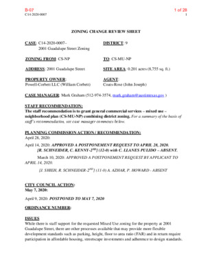
C14-2020-0007 1 ZONING CHANGE REVIEW SHEET CASE: C14-2020-0007– 2001 Guadalupe Street Zoning ZONING FROM: CS-NP DISTRICT: 9 TO: CS-MU-NP ADDRESS: 2001 Guadalupe Street PROPERTY OWNER: Powell-Corbett LLC (William Corbett) SITE AREA: 0.201 acres (8,755 sq. ft.) AGENT: Coats-Rose (John Joseph) CASE MANAGER: Mark Graham (512-974-3574, mark.graham@austintexas.gov ) STAFF RECOMMENDATION: The staff recommendation is to grant general commercial services – mixed use – neighborhood plan (CS-MU-NP) combining district zoning. For a summary of the basis of staff’s recommendation, see case manager comments below. PLANNING COMMISSION ACTION / RECOMMENDATION: April 28, 2020: April 14, 2020: APPROVED A POSTPONEMENT REQUEST TO APRIL 28, 2020. [R. SCHNEIDER, C. KENNY-2ND] (12-0) with C. LLANES PULIDO – ABSENT. March 10, 2020: APPROVED A POSTPONEMENT REQUEST BY APPLICANT TO [J. SHIEH, R. SCHNEIDER-2ND] (11-0) A. AZHAR, P. HOWARD - ABSENT APRIL 14, 2020. CITY COUNCIL ACTION: May 7, 2020: April 9, 2020: POSTPONED TO MAY 7, 2020 ORDINANCE NUMBER: ISSUES While there is staff support for the requested Mixed Use zoning for the property at 2001 Guadalupe Street, there are other processes available that may provide more flexible development standards such as parking, height, floor to area ratio (FAR) and in return require participation in affordable housing, streetscape investments and adherence to design standards. 1 of 28B-07 C14-2020-0007 2 CASE MANAGER COMMENTS: The subject lot is on the east side of Guadalupe Street at the south end of “The Drag,” a nickname for the portion of Guadalupe Street along the western edge of the University of Texas (UT) Austin Campus. The lot is situated between the five-story University of Texas, McCombs Business School on the south and the two story Dobie Center retail buildings to the north, in the shadow of the 27 story Dobie residential tower. This busy section of the West Campus Neighborhood has many apartments and condominiums housing UT students as well as food, clothing, school supplies and service businesses catering to students and university employees. The 0.201 acres (8,755 square foot) parcel is located on the northeast corner of Guadalupe Street and West 20th Street. On the parcel there are three retail commercial buildings, two one story buildings and a two story building. There is also outside seating between the building and Guadalupe Street for patrons of the food oriented businesses. The adjacent lot to the north is vacant. The current zoning is General Commercial Services - Neighborhood Plan (CS-NP) district. The applicant is requesting the addition of Mixed Use (MU) combining to allow building up to 66 dwelling units on the lot. Guadalupe is a designated Core Transit Corridor and supports mixed use and intensity of use. University Neighborhood Overlay The subject tract is within the University Neighborhood Overlay (UNO) district (LDC 25-2 Section 179). The purpose of the district is to promote high density redevelopment, provide a mechanism for the creation of a densely populated but livable and pedestrian friendly environment. The Future Land Use Map (FLUM) indicates Mixed Use, Transportation. The current request is consistent with the FLUM. A representative of University Area Partners responded to the hearing notice for this case in opposition to the request. They pointed out that the purpose (12.1.1) of UNO is to establish design criteria for all buildings and streetscapes within the UNO District with the goal of reinforcing the human scale/pedestrian friendly environment of the district. Participating lots in the UNO: Dobie subdistrict adhere to design standards for building walls and roof planes and provide street trees, pedestrian scale lighting and street furnishings, including benches, bike racks and trash receptacles. To participate, the property owner files a site plan and elects for the property to be governed by the UNO District Requirements (25-2-751). Properties in the UNO have a process for reducing parking and setback requirements. A site plan filed under the UNO provisions is reviewed for building design and may achieve increase height and allowed Floor to Area Ratio (FAR). UNO also requires an affordable housing commitment for properties that opt-in to UNO district governance. 2 of 28B-07 C14-2020-0007 3 Height, Parking Building heights along Guadalupe Street and governed by the UNO Dobie district have a height limited of 65 feet. That limit is 5 feet more than the underlying CS zoning height limit because of a provision in (25-2-752) that says UNO division of the Land Development Code supersedes other provisions of this title to the extent of conflict. Legal Description: Request From General Commercial Services – Neighborhood Plan (CS-NP) combining district to General Commercial Services – Mixed Use – Neighborhood Plan (CS-MU-NP) combining district. Lot 5 Outlot 21 division of Louis Horsts Subdivision (tax parcel 2016168899) as recorded in Book ‘Z,’ Page 594 and Book ‘Z,’ Page 613 of the Deed Records of Travis County, Texas. BASIS OF RECOMMENDATION: 1. The proposed zoning should be consistent with the purpose statement of the district sought. (CS) General Commercial Services district is intended predominately for commercial and industrial activities of a service nature having operating characteristics or traffic service requirements generally incompatible with residential environments. MU – Mixed Use combining district is intended for combination with selected base districts, in order to permit any combination of office, retail, commercial, and residential uses within a single development. The Neighborhood Plan FLUM supports mixed use with retail and residential, the UNO/Dobie district supports mixed use residential and the Central Austin Combined Neighborhood Planning Area supports mixed commercial and residential uses in this area. 2. The proposed zoning should satisfy a real public need and not provide special privilege to the owner. There is a growing demand for housing in the University and Downtown Austin area. This area is well suited for people who walk and use public transportation to take advantage of the jobs, entertainment, goods and services along the Guadalupe corridor. There is a lack of affordable housing for students and this location would be very convenient for students. There are many residential buildings currently under construction near the Guadalupe corridor and near UT. 3. Zoning should allow for reasonable use of the property. The addition of residential uses is a reasonable way to increase the intensity of use for the subject property. 3 of 28B-07 C14-2020-0007 4 EXISTING ZONING AND LAND USES: Site North South East West Zoning Land Uses CS-NP CS-NP, UNZ Restaurant, retail, personal services Vacant land, entertainment, retail, residential, UT education CS-NP, DMU Education MF-4, CS-NP, GR-NP CS-NP Residential condos, parking, University Bldgs. Restaurants, repair shop, church NEIGHBORHOOD PLANNING AREA: Central Austin Combined Neighborhood Plan (West University). Current land use on FLUM: Mixed Use. Proposed land use: Mixed Use. A Neighborhood Plan amendment is NOT required. TIA: The TIA determination is deferred until site plan application, when land use and intensities will be finalized. WATERSHED: Shoal Creek – Urban. Impervious coverage allowed: 95% OVERLAYS: Green Building Mandatory: University Neighborhood Overlay. Neighborhood Planning Area: West University. Residential Design Standards: LDC/25-2-Subchapter F. West Campus Neighborhood Overlay: DOBIE SCHOOLS: • AISD: Lee Elementary Kealing Middle McCallum High NEIGHBORHOOD ORGANIZATIONS Austin Independent School District Austin Lost and Found Pets Austin Neighborhoods Council Bike Austin Central Austin Community Development Corporation Friends of Austin Neighborhoods Homeless Neighborhood Association My Guadalupe Neighborhood Empowerment Foundation Preservation Austin SELTexas Sierra Club Austin Regional Group The University of Texas at Austin University Area Partners 4 of 28B-07 C14-2020-0007 5 AREA CASE HISTORIES: Number C14-04-0021 Request Commission City Council To Grant Apvd. (05/19/2005) C14-2007-0262 To Grant Apvd. (06/11/2009) C14-2016-0059 KKG 1 (Kappa Kappa Gamma) 2001 University Ave C14H-2009-0013 Kappa Kappa Gamma House 2001 University Ave C14-2016-0058 KKG 2 (Kappa Gamma House) 1911 ½ University Ave MF4-H-NP to GO-H-NP To Grant Apvd. (09/22/2016) MF-4-NP to MF-4-H-NP To Grant Apvd. (08-06-2009) To Grant Apvd. (09/22/2016) Central Austin Combined NP (West University) Rezoning. To change base district zoning on 454.13 acres on 329 tracts Central Austin Combined Neighborhood Planning Area Vertical Mixed Use. To add V, vertical mixed use to 20.42 acres of land. MF-4-NP to GO-CO-NP Conditions: Uses not permitted: Professional office, medical offices- exceeding 5000 sq. ft. gross floor area, administrative and business offices, personal services, medical offices-not exceeding 5000 sq. ft. gross floor area. RELATED CASES: C14-04-0021 West University Neighborhood Plan C14-2007-0262 Central Austin Combined Neighborhood Planning Area Vertical Mixed Use 5 of 28B-07 Bicycle Route Yes Yes Capital Metro (within ¼ mile) No Yes C14-2020-0007 6 OTHER STAFF COMMENTS: Transportation Street Characteristics Name ROW Pavement Classification Sidewalks W. 20th St 70’ Guadalupe 125’ 30’ 65’ Comprehensive Planning Level 1 (local) Level 3 (Minor Arterial) Yes Yes The zoning case is located on the northeast corner of W. 20th Street and Guadalupe Street on a 0.201 acre tract of land that is located in the Downtown (Imagine Austin) Regional Center. The subject property is located within the boundaries of the Central Austin Neighborhood Planning Area, in West University and contains a small two story building with retail shops. Surrounding land uses includes retail uses to the north, including a Target store; to the south is an office building and a University of Texas building; to the east is an apartment building and a parking garage; to the west is a shopping center and a church. The proposed use is 66 unit multistory multifamily residential housing project. Connectivity: Public sidewalks are located partially along West 20th Street and are on both sides of Guadalupe Street. Bike lanes are also located on both sides of Guadalupe Street. A CapMetro transit stop is located less than 100 feet away on Guadalupe Street. The mobility and connectivity options in this area are excellent. Central Austin Combined Neighborhood Planning Area (CACNP) The Central Austin Combined Neighborhood Plan Future Land Use Map identifies the subject area as being classified as ‘Mixed Use;’ Zone CS-MU is permitted under this future land use category. Mixed Use is meant to encourage more retail and commercial services within walking distance of residents. The subject property is also located in the University Area Overlay (UNO) District, which allows for denser, pedestrian oriented, commercial and multi-family development. The following Goals, Objectives and Recommendations in the CACNP are applicable to this case: Goal Three: Allow mixed-use development along the existing commercial corridors that is pedestrian oriented, neighborhood friendly, neighborhood scaled, and serves neighborhood needs. (p. 74) 6 of 28B-07 C14-2020-0007 7 Goal Four: West Campus should become a dense, vibrant, mixed-use and pedestrian oriented community. (p. 83) Objective 4.1: Promote quality, higher density mixed use and multi-family development in West Campus while preserving nearby single-family neighborhoods. (p. 85) Recommendation 3: Establish the University Neighborhood Overlay (UNO) for the West Campus area that allows denser, pedestrian-oriented commercial and multi-family development (see “Proposed University Neighborhood Overlay [UNO] Boundaries and Districts” map on page 87 and Architectural Guidelines for the UNO District beginning on page 116). The overlay should function as providing a development bonus to projects that choose to follow the provisions of the overlay. The development bonuses should include, but not be limited to, providing for (p. 86) • Increasing building heights above what is allowed by the base zoning district • Reducing site area requirements for multi-family development • Relaxing and/or eliminating other site development standards such as allowing higher amounts of impervious cover than the base zoning district, waiver of compatibility standards, and reduction of required parking spaces for commercial uses. The provisions of the overlay should be designed to promote projects that are long lasting and of high quality. Map on page 87 identifies this property in the ‘Dobie District’ which would allow a building to be 60 feet tall or five stories in height) Goal 4 of CACNP appears to support the relaxation or elimination of various site development standards in the UNO district to promote a ‘dense, vibrant, mixed-use and pedestrian oriented community’ and multifamily development and appears to be supported by the CACNP. Imagine Austin The Imagine Austin Comprehensive Plan locates the subject property within the boundaries of a ‘Regional Center’, as identified on the Imagine Austin’s Growth Concept Map. A Regional Center is the most urban of the three activity centers outlined in the growth concept map. These centers are and will be the retail, cultural, recreational, and entertainment destinations for Central Texas. The following Imagine Austin policies are also applicable to this case: • LUT P3 Promote development in compact centers, communities or along corridors that are connected by roads and transit, are designed to encourage walking and bicycling, and reduce healthcare, housing and transportation costs. 7 of 28B-07 C14-2020-0007 8 • LUT P5. Create healthy and family-friendly communities through development that includes a mix of land uses and housing types and affords realistic opportunities for transit, bicycle, and pedestrian travel and provides both community gathering spaces, parks and safe outdoor play areas for children. • LUT P7. Encourage infill and redevelopment opportunities that place residential, work, and retail land uses in proximity to each other to maximize walking, bicycling, and transit opportunities. • HN P11. Protect neighborhood character by directing growth to areas of change and ensuring context sensitive infill in such locations as designated redevelopment areas, corridors, and infill sites. Based on the property being located within a Regional Center and in the UNO District, which both encourage high density mixed use and multifamily development, the proposed project appears to be supported by the Imagine Austin Comprehensive Plan. Environmental 1. The site is not located over the Edwards Aquifer Recharge Zone. The site is located in the Shoal Creek Watershed of the Colorado River Basin, which is classified as an Urban Watershed by Chapter 25-8 of the City's Land Development Code. It is in the Desired Development Zone. 2. Zoning district impervious cover limits apply in the Urban Watershed classification. 3. According to floodplain maps there is no floodplain within or adjacent to the project location. 4. Standard landscaping and tree protection will be required in accordance with LDC 25-2 and 25-8 for all development and/or redevelopment. 5. At this time, site specific information is unavailable regarding vegetation, areas of steep slope, or other environmental features such as bluffs, springs, canyon rimrock, caves, sinkholes, and wetlands. 6. This site is required to provide on-site water quality controls (or payment in lieu of) for all development and/or redevelopment when 8,000 s.f. cumulative is exceeded, and on site control for the two-year storm. Site Plan SP1. Site plans will be required for any new development other than single-family or duplex residential. 8 of 28B-07 SP4. SP5. SP6. C14-2020-0007 9 SP2. Any development which occurs in an SF-6 or less restrictive zoning district which is located 540 feet or less from property in an SF-5 or more restrictive zoning district will be subject to compatibility development regulations. SP3. Any new development is subject to Subchapter E. Design Standards and Mixed Use. Additional comments will be made when the site plan is submitted. FYI: Additional design regulations will be enforced at the time a site plan is submitted. FYI: The subject property is included in an approved site plan SP-2007-0634D. University Avenue Improvements. Improvements in the right-of-way to include new curb, gutter, sidewalks and utilities. SMALL LOTS Small lot regulations will apply. There are reduced setbacks for lots smaller than 20,000 sq. feet with frontages less than 100 feet. Reductions apply to side and rear yards (25-2-1062) and the location of driveways and parking areas (25-2-1067). 25-2-1062 has the sliding scale for small lots setbacks. SCREENING REQUIREMENTS SP7. FYI: Screening is required for off-street parking, the placement of mechanical equipment, storage, and refuse collection if a person is constructing a building (25-2-1066). DEMOLITION AND HISTORIC RESOURCES SP8. The applicant is responsible for requesting relocation and demolition permits once the site plan is approved. The City Historic Preservation Officer will review all proposed building demolitions and relocations prior to site plan approval. If a building meets city historic criteria, the Historic Landmark Commission may initiate a historic zoning case on the property. RESIDENTIAL DESIGN STANDARDS OVERLAY SP9. The site is subject to 25-2 Subchapter F. Residential Design and Compatibility Standards. UNIVERSITY NEIGHBORHOOD OVERLAY SP10. This site is located in the University Neighborhood Overlay LDC Subchapter C Article 3 Division 9 (25-2-751) a. This site is in the Dobie Subdistrict i. The maximum height for this lot is 65’ if elect to be governed my UNO. 9 of 28B-07 C14-2020-0007 10 Austin Water Utility WW1. The landowner intends to serve the site with City of Austin water and wastewater utilities. The landowner, at own expense, will be responsible for providing any water and wastewater utility improvements, offsite main extensions, utility relocations and or abandonments required by the land use. The water and wastewater utility plan must be reviewed and approved by Austin Water for compliance with City criteria and suitability for operation and maintenance. All water and wastewater construction must be inspected by the City of Austin. Based on current public infrastructure configurations, it appears that service extension requests (SER) will be required to provide service to this lot. For more information pertaining to the Service Extension Request process and submittal requirements contact Alberto Ramirez with Austin Water, Utility Development Services at 625 E. 10th St., 7th floor. Ph: 512-972-0211. The landowner must pay the City inspection fee with the utility construction. The landowner must pay the tap and impact fee once the landowner makes an application for a City of Austin water and wastewater utility tap permit. INDEX OF EXHIBITS TO FOLLOW Exhibit A: Zoning Map Exhibit B: Aerial Map Exhibit C: Letter from John Joseph to University Partners (Mike McHone) Exhibit D: Letter from Mike McHone to John Joseph 10 of 28B-07 EXHIBIT A WMARTINLUTHERKINGJRBLVDE 21ST STGUADALUPESTSAN ANTONIO STSOUTH MALL UTNUECESSTSANANTONIOSTW 21ST STW 20TH STINNER CAMPUS DRCOLORADOSTW18THSTW 22ND STLAVACASTWHITIS AVEUNIVERSITY AVEDMU-COGOMF-4-NPMF-4-NPCSMF-4-NPCS-NPCS-NPGO-NPCS-CO-NPGOCSCS-1-NPCS-NPDMUGR-NPCS-NPMF-4-NPCS-NPCS-NPDMU-COMF-4-NPGR-NPPCS-1-NPDMU-HCS-MU-CO-NPGR-NPDMU-COMF-4-H-NPCS-MU-NP/MF-6-CO-NPCS-NPGR-MU-NPCS-NPDMUGO-H-CO-NPMF-5DMU-COCS-NPDMUCS-NPMF-4-NPMF-4-NPGOCS-CO-NPDMUGO-CO-NPCS-CO-NPMF-4-NPUNZMF-4-H-NPMF-4-NPMF-4-NPDMUDMU-CURECS-NPGR-NPCS-NPMF-4UNZGOCS-NPMF-5±This map has been produced by the Planning Development Review Department for the sole purpose ofgeographic reference. No warranty is made by the City of Austin regarding specific accuracy or completeness.ZONING CASE#:LOCATION:SUBJECT AREA:C14-2020-00072001 Guadalupe Street0.2 ACRES1'' = 200'SUBJECT TRACT2001 Guadalupe St. ZoningZONING BOUNDARY11 of 28B-07 EXHIBIT B WMARTINLUTHERKINGJRBLVDE 21ST STGUADALUPESTSAN ANTONIO STSOUTH MALL UTNUECESSTSANANTONIOSTW 21ST STW 20TH STINNER CAMPUS DRCOLORADOSTW18THSTW 22ND STLAVACASTWHITIS AVEUNIVERSITY AVEDMU-COGOMF-4-NPMF-4-NPCSMF-4-NPCS-NPCS-NPGO-NPCS-CO-NPGOCSCS-1-NPCS-NPDMUGR-NPCS-NPMF-4-NPCS-NPCS-NPDMU-COMF-4-NPGR-NPPCS-1-NPDMU-HCS-MU-CO-NPGR-NPDMU-COMF-4-H-NPCS-MU-NP/MF-6-CO-NPCS-NPGR-MU-NPCS-NPDMUGO-H-CO-NPMF-5DMU-COCS-NPDMUCS-NPMF-4-NPMF-4-NPGOCS-CO-NPDMUGO-CO-NPCS-CO-NPMF-4-NPUNZMF-4-H-NPMF-4-NPMF-4-NPDMUDMU-CURECS-NPGR-NPCS-NPMF-4UNZGOCS-NPMF-5±This map has been produced by the Planning Development Review Department for the sole purpose ofgeographic reference. No warranty is made by the City of Austin regarding specific accuracy or completeness.ZONING CASE#:LOCATION:SUBJECT AREA:C14-2020-00072001 Guadalupe Street0.2 ACRES1'' = 200'SUBJECT TRACT2001 Guadalupe St. ZoningZONING BOUNDARY12 of 28B-07 COATS ROSE A PROFESSIONAL CORPORATION Exhibit C JMJOSEPH@COATSROSE.COM DIRECT: (512) 541-3593 FAX: (512) 469-9408 April 7, 2020 JOHN M. JOSEPH DIRECTOR Mr. Mike McHone, Vice President University Area Partners 2026 Guadalupe St. Austin, TX 78705 VIA EMAIL: MCHONE1234@SBCGLOBAL.NET Re: 2001 Guadalupe St.; Case Number C14-2020-0007 Dear Mike: As we discussed on the phone before this Corona virus mess began, I would very much appreciate a telephone conference this week to discuss our client’s zoning request and the University Neighborhood Overlay (“UNO”) design standards. In seeking the addition of residential zoning for the subject property located at 2001 Guadalupe (“Property”), we are not seeking to avoid the design standards of the University Neighborhood Overlay. Because of the uncertainty of the availability of the new land development code rewrite, my client wishes to obtain residential development options for the Property as a matter of right. It is hard to imagine how this Property, or anyone could argue that this Property, would not be an appropriate location for residential use. As you know the chief objective is to be able to take advantage of the City of Austin residential density bonuses and incentives to achieve additional density, which is not available under the University Neighborhood Overlay. As you know, under that overlay the redevelopment of the Property would not be able to achieve a height in excess of 65 feet, even with the compliance with all the City of Austin’s density incentives. For your consideration and hopefully for your acceptance, my client proposes the following: Upon approval by the City of Austin of the mixed-use zoning designation (“CS-MU-NP”) for the Property, the Property owner will impress the subject Property a recorded restrictive covenant, which shall include the following design standards language, quoted from Section 12 of TERRACE 2, 2700 VIA FORTUNA, SUITE 350, AUSTIN, TEXAS 78746 PHONE: (512) 469-7987 FAX: (512) 469-9408 coatsrose.com HOUSTON | AUSTIN | DALLAS | SAN ANTONIO | NEW ORLEANS | CINCINNATI 13 of 28B-07 14 of 28B-07 April 7, 2020 Page 3 12.1.2 – Building Design Standards Exhibit “A” Buildings, including enclosed and unenclosed parking garages, shall avoid long expanses of blank, unarticulated exterior walls visible from a street, public plaza or public open space. The direction given here regarding massing and articulation of a building's public exterior is considered a matter of human comfort, achievable in any architectural style or design approach. For a project to be in compliance with the design guidelines, it must score a minimum of 8 points using the following point system: a. interruptions in the plane of a building façade shall be introduced at a spacing not to exceed 40-feet. This can be achieved through the articulation of wall surfaces, changes in fenestration patterns, or other building design elements. (2 points) b. use of contrasting materials, textures and colors, (2 points) c. introduction of windows and openings that promote visual and physical interaction between interior of building and street activity (2 points), d. the use of awnings or colonnades at street level, (1 point) e. variety of the roof line, (1 point) f. articulation of building entrances so they are distinguished from the general massing of the building, (1 point) g. the use of functional elements such as balconies or projected window boxes to promote the breakdown of a façade. (1 points) 12.1.3 - Placement of Windows a. inhabited spaces on the ground level shall have a minimum of 70% glass at sides facing a street; where inhabited spaces at ground level hold residential uses, the minimum glass percentage shall be reduced to 40%. b. inhabited spaces on the second level shall have a minimum of 40% glass at sides facing a street. c. glass at ground/street level and second level must have a transmittance ratio of 0.6 or higher. 12.1.4 - Building Materials a. the use of EIFS below a height of 65 feet is not allowed. b. the use of highly reflective glass is not allowed. 000000.000001\4838-6080-3753.v1 15 of 28B-07 April 7, 2020 Page 4 c. wood shingles and wood siding are not allowed. d. the use of exposed concrete block as a finish material is not allowed. This includes split- faced, ground face and integrally colored flat concrete block. 12.1.5 - Parking Garages - Flat Slab Requirement Where adjacent to a public street, the floors of a structured parking garage, either stand-alone or mixed into the mass of a building, must either be flat or, if sloping, be hidden from view from the street(s), public plaza or public open space. 12.1.6 - Historical Authenticity Buildings located adjacent to a historic landmark shall create some accommodating element in their massing which will mitigate the contrast between the two. 12.1.7 - Streetscape Design Standards Includes standards for placement of street trees, light poles and street furnishings. I. STREET TREES: An owner shall install, irrigate and maintain street trees along an adjacent street right-of-way. a. all new trees shall be shade trees (non-utility compatible), unless conflict with utilities exist; see I (f). Refer to the Environmental Criteria Manual (ECM) Appendix 'F', for approved street trees species. b. street trees must be in scale with adjacent buildings and must be placed so as to create a continuous canopy at maturity. c. trees shall have a minimum of 5-inch caliper (measured 12 inches above the root ball) at installation, with a typical canopy height of 14 to 16 feet for Class I Shade trees. Minimum clearance for tree limbs and branches must be 7′-6″ above the level of the sidewalk to avoid potential conflict with pedestrians. Trees shall be trimmed proportionally to an ultimate clearance height of 14′-0″ above the sidewalk and street at maturity. d. trees shall be installed 4′-0″ O.C. back from face of curb, parallel to the curb. e. the standard tree spacing is 22′-0″ O.C. If existing conditions preclude the standard spacing, shade trees may be planted at a distance not to exceed 30′-0″ O.C.; utility compatible trees spacing shall not exceed 24′-0″ O.C. f. where existing utilities are in conflict with in-ground planting of shade trees, applicant shall: - plant utility compatible trees in above grade planters if both overhead and underground utilities are in place; 000000.000001\4838-6080-3753.v1 16 of 28B-07 April 7, 2020 Page 5 - plant utility compatible trees in-ground, if conflict is with overhead lines; - plant shade trees in above grade planters, if conflict is with underground utilities. g. a minimum pedestrian clear zone width of 5 feet will be provided between the edge of a tree grate/planting bed and any walls/planters and/or other vertical element associated with a development (refer to COA Detail 710S-6A). If above grade planters are used, the minimum pedestrian clear zone shall be 6 feet (as per COA Detail 432S-7D). h. a new tree planted in a sidewalk must have a 6 feet x 6 feet tree grating which shall comply with COA Standard Detail 437S-2. A different plant bed configuration with or without a tree grate, may be approved by the Planning and Development Review Department, based on specific needs and an alternative form of equivalent compliance. II. PEDESTRIAN SCALE STREET LIGHTING: All development shall provide pedestrian scale street lighting along an adjacent street right-of- way. a. the standard pedestrian scale streetlight pole spacing is 44′-0″ O.C.; lights may be placed as far apart as 72′-0″ O.C. if existing conditions preclude the recommended spacing. b. on corner properties, the distance between the corner and the first light pole shall not exceed 25′-0″. c. light poles shall be installed 4′-0″ O.C. back from face of curb, aligned with the street trees. d. A minimum spacing of 11′-0″ O.C. shall be maintain between a light pole and a street tree. e. the "Pecan Street Light Pole" is the University Neighborhood Overlay fixture. III. STREET FURNISHINGS: Street furnishings, including benches, bike racks and trash receptacles, shall be provided by any development located within the Dobie, Guadalupe and Inner West Campus Sub-districts. In the Outer West Campus Sub-district, only developments with greater than 150 linear feet of cumulative street frontage shall be required to provide street furnishings described here. Within a given project, the street furnishings will compliment each other and the development they are a part of. Permitted finishes shall be one or a combination of the following: decay resistant hardwoods (benches slats only), and corrosion resistant finishes such as aluminum, cast iron, stainless steel or galvanized steel. 000000.000001\4838-6080-3753.v1 17 of 28B-07 April 7, 2020 Page 6 Whenever applicable, street furnishings will be anchored with rust-resistant fasteners and treated with rust prohibitive coating, zinc epoxy primer, and powdercoat finish for superior corrosion resistance. All surfaces shall be pretreated with a grafitti preventer. The street furnishing requirements are as follows: a. Trash Receptacles: A minimum of one (1) receptacle shall be provided: • For mid-block properties, the receptacle shall be located within 12 feet of a primary entrance(s), aligned with lights and trees. • For corner properties, two (2) additional receptacles shall be provided adjacent to the corner ramps, facing both streets, (as per COA Standard Detail 432S-8C). b. Bike Racks: A minimum of four (4) bike racks, in addition to those required in other sections of the code. • Bike racks shall be installed perpendicular to the curb, 4′-0″ O.C. back from face of curb, aligned with trees and light poles (as per COA Standard Detail 710S-6A). • Bike racks shall be Class III, Type 1 inverted "U"(1-2 spaces only) - as per COA Standard Detail 710-S-1 (page 1 of 3). • Racks shall be made of continuous welds, with smooth edges. Finishes shall be one of the following: cast aluminum, stainless or galvanized steel or plastic color coated carbon steel. • Stainless steel tubing shall be 1 ½ inch, • When applicable, a fade resistant powder coat finish color shall use RAL color standards for compatibility with other products. c. Benches: A minimum of two (2) 5-foot wide benches with middle arm shall be installed per street frontage: • Standard placement: perpendicular to the curb and aligned with the trees and light poles, and facing each other arranged in a conversational grouping (as per COA Standard Detail 432S-9C), • If existing conditions preclude the standard placement benches may be placed parallel to the building, facing the street, within 6 inches of the building exterior wall (as per COA Standard Detail 432S), • Finishes may be metal or a combination of metal frame with wood slats. • Only hardwoods that are responsibly produced, durable and resistant to fire, moisture, insects, decay or vandalism i.e. Redwoods, shall be used. Stained, painted or varnished wood shall not be allowed. 000000.000001\4838-6080-3753.v1 18 of 28B-07 April 7, 2020 Page 7 • If a corner property, two (2) benches will be installed along each street frontage for a total of four (4) benches minimum. 000000.000001\4838-6080-3753.v1 19 of 28B-07 Exhibit D 20 of 28B-07 21 of 28B-07 22 of 28B-07 23 of 28B-07 24 of 28B-07 25 of 28B-07 26 of 28B-07 27 of 28B-07 28 of 28B-07