B-06 (C14-2019-0003 - Lantana Block P, Lot 3; District 8) — original pdf
Backup
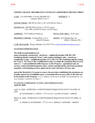
ZONING CHANGE / RESTRICTIVE COVENANT AMENDMENT REVIEW SHEET CASE: C14-2019-0003 / C14-85-288.8(RCA5) – ZONING FROM: GR-NP for Tract 1; CS-1-CO-NP for Tract 2 ZONING TO: GR-MU-NP for Tract 1 (35.371 acres); Lantana, Block P, Lot 3 DISTRICT: 8 CS-1-MU-CO-NP for Tract 2 (0.279 acres) ADDRESS: 7415 Southwest Parkway PROPERTY OWNER: Lantana Place, L.L.C. (Erin D. Pickens) TOTAL SITE AREA: 35.67 acres AGENT: LJA Engineering, Inc. (Paul J. Viktorin, P.E.) CASE MANAGER: Wendy Rhoades (512-974-7719, wendy.rhoades@austintexas.gov) STAFF RECOMMENDATION: The Staff recommendation is to: grant community commercial – mixed use – neighborhood plan (GR-MU-NP) combining district zoning for Tract 1 and commercial-liquor sales – mixed use – conditional overlay – neighborhood plan (CS-1-MU-CO-NP) combining district zoning for Tract 2. On Tract 2, the Conditional Overlay is to limit the maximum floor-to-area ratio is 1 : 1 and prohibit the following uses on the Property: agricultural sales & services, commercial blood plasma center, custom manufacturing, electronic prototype assembly, exterminating services, plant nursery and veterinary services, and amend the Restrictive Covenant to remove the provision establishing the maximum net leasable square feet of buildable space or maximum floor-to-area ratio (FAR) that can be developed on the Property. For a summary of the basis of Staff’s recommendation, see case manager comments on Page 2. PLANNING COMMISSION ACTION / RECOMMENDATION: April 28, 2020: April 14, 2020: APPROVED A POSTPONEMENT REQUEST BY STAFF TO APRIL 28, 2020 [R. SCHNEIDER; C. KENNY – 2ND] (12-0) C. LLANES PULIDO – ABSENT March 10, 2020: APPROVED A POSTPONEMENT REQUEST BY STAFF TO APRIL 14, 2020 [J. SHIEH; R. SCHNEIDER – 2ND] (11-0) A. AZHAR, P. HOWARD – ABSENT 1 of 23B-06 C14-2019-0003 / C14-85-288.8(RCA5) Page 2 February 25, 2020: APPROVED A POSTPONEMENT REQUEST BY STAFF TO MARCH 10, 2020 [R. SCHNEIDER; C. KENNY – 2ND] (12-0) J. SHIEH – ABSENT January 28, 2020: APPROVED A POSTPONEMENT REQUEST BY STAFF TO FEBRUARY 25, 2020 [J. THOMPSON; A. AZHAR – 2ND] (10-0) C. HEMPEL – RECUSED; C. LLANES PULIDO, P. SEEGER – ABSENT December 17, 2019: APPROVED A POSTPONEMENT REQUEST BY THE STAFF TO JANUARY 28, 2020, BY CONSENT [P. HOWARD; Y. FLORES – 2ND] (10-0) G. ANDERSON, C. LLANES PULIDO, T. SHAW – ABSENT [P. HOWARD; C. KENNY – 2ND] (11-0) P. SEEGER, J. SHIEH – ABSENT June 25, 2019: APPROVED AN INDEFINITE POSTPONEMENT REQUEST BY THE STAFF, BY CONSENT CITY COUNCIL ACTION: May 7, 2020: April 23, 2020: March 12, 2020: APPROVED A POSTPONEMENT REQUEST BY STAFF TO APRIL 23, 2020. VOTE: 9-0, MAYOR ADLER; COUNCIL MEMBER HARPER-MADISON – OFF THE DAIS February 6, 2020: APPROVED A POSTPONEMENT REQUEST BY STAFF TO MARCH 12, 2020. VOTE: 10-0, COUNCIL MEMBER CASAR – OFF THE DAIS ORDINANCE NUMBER: ISSUES: A related project consent agreement item has been placed on the agenda to address residential use for the property, and under what circumstances it could occur. On March 4, 2020, the project consent agreement completed review by the Environmental Commission. CASE MANAGER COMMENTS: The rezoning area consists of a platted lot that contains a commercial center that contains office, financial services, retail, restaurant uses and a movie theater, and is located at the southwest corner of Southwest Parkway and West William Cannon Drive. The property has community commercial – neighborhood plan (GR-NP) combining district zoning with the exception of one 12,138 square foot single story building that has commercial-liquor sales – conditional overlay – neighborhood plan (CS-1-CO-NP) district zoning by a 2018 case. There is a landscaped median dividing the east and west lanes of Southwest Parkway, and the 2 of 23B-06 C14-2019-0003 / C14-85-288.8(RCA5) Page 3 north and south lanes of William Cannon; median breaks allow for full turning movements on both roadways. There is undeveloped land on the north side of Southwest Parkway (DR; GO), undeveloped land and an AMD facility to the east (GR-NP), undeveloped land and apartments to the south (CS-NP; P-NP) and offices to the west (CS-NP). Please refer to Exhibits A (Zoning Map), A-1 (Aerial Exhibit), B (Recorded Plat) and C (Approved Site Plan). The Applicant requests the addition of the mixed use (-MU) combining district to both tracts, as the first step in developing up to 400 multifamily residential units on the undeveloped southeast portion of the property. On Tract 2, the –CO for the list of prohibited uses is not proposed to change. The Applicant also requests an amendment of the 1986-87 Restrictive Covenant to remove the provision establishing the maximum net leasable square feet of buildable space or maximum floor-to-area ratio (FAR) that can be developed on the Property, because these terms apply to commercial rather than multifamily residence use. All other provisions of the Restrictive Covenant would remain intact. Please refer to Exhibit D (1986 Restrictive Covenant and 1987 Modification). BASIS OF RECOMMENDATION: The proposed zoning should be consistent with the purpose statement of the district sought. For Tract 1: The proposed community commercial (GR) district is intended for office and commercial uses serving neighborhood and community needs, including both unified shopping centers and individually developed commercial sites, and typically requiring locations accessible from major trafficways. For Tract 2: The commercial – liquor sales (CS-1) zoning district is intended for commercial and industrial activities of a service nature which typically have operating characteristics or traffic service requirements generally incompatible with residential environments, and specifically includes liquor sales as a permitted use. The Conditional Overlay (CO) combining district may be applied in combination with any base district. The district is intended to provide flexible and adaptable use or site development regulations by requiring standards tailored to individual properties. For Tracts 1 and 2: The mixed use (MU) district is intended to allow for office, retail, commercial and residential uses to be combined in a single development. The neighborhood plan (NP) district denotes a tract located within the boundaries of an adopted Neighborhood Plan. Zoning changes should promote the policy of locating retail and more intensive zoning near the intersections of arterial roadways or at the intersections of arterials and major collectors. Staff supports the Applicant’s request based on the presence of supporting office and commercial developments within and in proximity to the property, and vehicular access to two arterial streets. 1. 2. 3 of 23B-06 C14-2019-0003 / C14-85-288.8(RCA5) Page 4 If Austin is to grow and evolve as a compact and connected city, as envisioned in the adopted Imagine Austin Comprehensive Plan (IACP), then development that provides additional housing units is necessary. One of the primary mechanisms for achieving compact growth will be development, or redevelopment, of larger sized properties such as this into higher density residential. In the broader city-wide context, adding a –MU overlay to office and commercial base zoning districts is a reasonable option for multiple-acre parcels developed or redeveloped for office / commercial / residential purposes. In conclusion, Staff believes the proposed GR-MU-NP and CS-1-MU-NP zonings and multifamily development is compatible with adjacent and nearby commercial and apartment developments. The proposed amendment to the Restrictive Covenant is acceptable given that the proposed multifamily development on the Property will occur under the terms of the related Project Consent Agreement. EXISTING ZONING AND LAND USES: Site ZONING GR-NP; CS-1-NP North DR; RR LAND USES Offices, financial services, retail, restaurant, theater; Undeveloped Undeveloped; Single family residences on large lots South CS-NP; P-NP; MF-2-NP; GO-NP Offices; Undeveloped; Multifamily residences East West GR-NP CS-NP Offices Offices NEIGHBORHOOD PLANNING AREA: Oak Hill Combined (West Oak Hill) TIA: Is not required WATERSHED: Williamson Creek – Barton Springs Zone – Contributing Zone CAPITOL VIEW CORRIDOR: No SCHOOLS: Oak Hill Elementary School NEIGHBORHOOD ORGANIZATIONS: 298 – Oak Hill Association of Neighborhoods 742 – Austin Independent School District 779 – Oak Hill Neighborhood Plan – COA Liaison 943 – Save Our Springs Alliance 1166 – Oak Hill Neighborhood Plan Contact Team 1228 – Sierra Group, Austin Regional Group 1318 – Covered Bridge Property Owners Association, Inc. 605 – City of Rollingwood SCENIC ROADWAY: Yes, Southwest Parkway (Low Intensity) Small Middle School Austin High School 1363 – SEL Texas 4 of 23B-06 C14-2019-0003 / C14-85-288.8(RCA5) Page 5 1528 – Bike Austin 1470 – Aviara HOA 1530 – Friends of Austin Neighborhoods 1596 – TNR BCP – Travis County Natural Resources 1616 – Neighborhood Empowerment Foundation 1714 – East Oak Hill Neighborhood Association AREA CASE HISTORIES: REQUEST MF-1 to MF-2 for Tract C (25.31 acres) NUMBER C14-87-145 – W William Cannon Dr at Southwest Pkwy – Lantana (10 residential tracts on 229.49 acres) COMMISSION CITY COUNCIL To Grant MF-2 Apvd MF-2 (08-16-1990). RELATED CASES: On August 14, 1986, GR district zoning was approved for the subject property (C14-85- 288.8). The rezoning area is all of Lot 3, Block P, Lantana Phase 1, Section 1, a subdivision recorded on May 11, 2000 (C8-84-102.03.1A). An administrative site plan which coincides with the rezoning area boundary was approved on April 30, 2015 (SP-2014-0262C – Lantana Block P, Lot 3 – expiration April 30, 2022). The permit issued on April 30, 2015 is for a 4-story professional office building, a 3-story medical office building, a 70,000 square foot hotel, a 46,000 square foot theater, and five buildings containing financial services, retail, and restaurant uses. The Floor-to-Area ratio shown on the approved site plan for the overall property is 0.2 : 1. The area of the approved site plan proposed for multifamily residential is known as Phase 5 and identified for General Office and Medical Office uses. On June 28, 2018, Council approved CS-1-CO-NP zoning for a 0.279 acre) footprint within the property (12,138 square feet – Tract 2). The –CO limits the FAR to 1:1 and prohibits agricultural sales & services, commercial blood plasma center, custom manufacturing, electronic prototype assembly, exterminating services, plant nursery and veterinary services (C14-2018-0005). Please refer to Exhibit E (2018 Rezoning Ordinance – Tract 2). A previous rezoning case for GR-MU-NP was filed in late 2015, but withdrawn prior to Planning Commission consideration (C14-2015-0134). The rezoning area is within the West Oak Hill Neighborhood Planning Area. The property is designated as Mixed Use on the Future Land Use Map, and the proposed rezoning to add the MU overlay does not require a plan amendment. An –NP combining district was added as part of the Neighborhood Plan Rezonings and was approved by Council in December 2008 (C14-2008-0125 – Ordinance No. 20081211-097). 5 of 23B-06 C14-2019-0003 / C14-85-288.8(RCA5) Page 6 EXISTING STREET CHARACTERISTICS: Name ROW West William Cannon Drive Southwest Parkway 140 feet 115 feet Level 4 (Arterial) Level 4 (Arterial) (with median) (with median) 120 feet 95 feet Pavement Classification Sidewalks Bicycle Route Capital Metro Yes Yes (within ¼ mile) No Yes, Shared lane Yes, wide shoulder No According to the Austin 2014 Bicycle Plan approved by Austin City Council in November, 2014, a protected bike lane is required for Southwest Parkway and William Cannon Drive. The Corridor Planning Office (CPO) plans to build the above-referenced protected bike lane for all ages and abilities. OTHER STAFF COMMENTS: Comprehensive Planning This property is located on the southwest corner of Southwest Parkway and W. William Cannon Drive on a property that is approximately 35.67 acres in size but this case only concerns a portion of the property that is not planned for commercial and office development. The case is also located within the boundaries of the Oak Hill Combined Neighborhood Planning Area. Surrounding land uses includes undeveloped land to the north; undeveloped land and a large apartment complex to the south; undeveloped land and AMD to the east; and undeveloped land and a large office complex to the west. This project is part of Lantana Place, which is a planned retail and mixed use development. The proposed use is a 600 unit multifamily apartment complex on the undeveloped south portion of the site. The plans as per the developer: Connectivity and Mobility: Since last year, public sidewalks have been installed along this portion of Southwest Parkway, and public sidewalks and CapMetro transit stop are preexisting along William Cannon Drive. The Walkscore for this site is 3/100, Car Dependent, meaning most errands require a car. Southwest Parkway is a busy auto-centric roadway but this area is gradually adding in pedestrian infrastructure. This portion of William Cannon also acts as a minor highway and the mobility and connectivity options offered currently offer this area are above average compared to other properties along Southwest Parkway because of the new public sidewalks and nearby Cap Metro transit stop. Oak Hill Combined Neighborhood Plan (OHCNP) The Oak Hill Combined Neighborhood Plan Future Land Use Map (FLUM) designates this portion of Southwest Parkway as ‘Mixed Use’ which is intended for a mix of office, retail, and residential uses. Zones GR-MU and CS-1 are permitted under this FLUM category. 6 of 23B-06 C14-2019-0003 / C14-85-288.8(RCA5) Page 7 The following text, goals, objectives and recommendations are taken from the OHCNP and are relevant to this case: Goal 6.A. Provide opportunities for high-quality new development and redevelopment. (p 66) Objective 6A.1: Ensure quality of new construction and renovations. (p 66) Goal 6.C: Create a mix of uses in existing corridors of commercial development that will provide a diversity of local services convenient to neighborhoods and establish commercial “nodes” (concentrated) (p 67) OHCNP Text (p. 79) Southwest Parkway presents its own set of unique challenges when making land use recommendations. Within the planning area, a large portion of the road is already covered by restrictive covenants or conditional overlays or is outside of the City’s zoning jurisdiction. Most of the land use recommendations pertain to property located on the south side of the roadway. · William Cannon Drive at Southwest Parkway — Mixed Use is recommended for this area because it is surrounded by a mix of offices and multifamily buildings. With access to both Southwest Parkway and William Cannon, this area is appropriate for a mix of office, retail, and residential uses. Additionally, current residences and offices in the surrounding area could be served by community-level retail here. (p 79) Conclusion: The Oak Hill Combined Neighborhood Plan’s FLUM and policies and text appears to support a mix of office, commercial, and residential uses in this portion of the planning area. Imagine Austin While this portion of Southwest Parkway and William Cannon are not situated along an Activity Corridor or Center, this area is developing into a regional commercial/mixed use node, which includes multifamily, large office complexes and commercial uses that are situated along a highly traveled thoroughfare. The following Imagine Austin Comprehensive Plan policies are applicable to this case: • LUT P3. Promote development in compact centers, communities, or along corridors that are connected by roads and transit, are designed to encourage walking and bicycling, and reduce healthcare, housing and transportation costs. • HN P1. Distribute a variety of housing types throughout the City to expand the choices able to meet the financial and lifestyle needs of Austin’s diverse population. Based on existing and developing commercial, multifamily, mixed use and office development being built in the area, and the project support the text and policies of the OHCNP, this project appears to support the Imagine Austin Comprehensive Plan. 7 of 23B-06 C14-2019-0003 / C14-85-288.8(RCA5) Page 8 8 of 23B-06 C14-2019-0003 / C14-85-288.8(RCA5) Page 9 Environmental This site is located over the Edwards Aquifer Contributing Zone. The site is in the Williamson Creek Watershed of the Colorado River Basin, which is classified as a Barton Springs Zone Watershed by Chapter 25-8 of the City’s Land Development Code. It is in the Drinking Water Protection Zone. According to floodplain maps there is no floodplain within the rezoning area. Stormwater flows to a water quality pond near the southeast property line. Impervious Cover Development of the property is subject to the terms of a Settlement Agreement between the City and Stratus Properties Inc. dated July 10, 2001 and allows for up to 60% net site area (32.234 acres). The amount of impervious cover shown on the approved site plan is 17.45 acres (54.14%), again, based on a net site area of 32.234 acres. The proposed rezoning is to occur within a building that is under construction and will not result in an increase in the amount of impervious cover. Site Plan and Compatibility Standards Site plans will be required for any new development other than single-family or duplex residential. Any development which occurs in an SF-6 or less restrictive zoning district which is located 540 feet or less from property in an SF-5 or more restrictive zoning district will be subject to compatibility development regulations. Any new development is subject to Subchapter E. Design Standards and Mixed Use. FYI – A conditional use permit for the cocktail lounge is required prior to establishing the use. For a site development permit the following rules may be applicable: This site is located within 1,000 feet of Southwest Parkway and within a Hill Country Roadway Corridor. The site is located within the low intensity zone of Southwest Parkway. Except for clearing necessary to provide utilities or site access, a 100-foot vegetative buffer will be required along Southwest Parkway. At least 40% of the site (excluding dedicated right-of-way) must be left in a natural state. The allowable height is as follows: Within 200 feet of Southwest Parkway the maximum height is 28 feet, and beyond 200 feet the maximum height is the lesser of the height permitted by the zoning or the site plan approved for the property; or 60 feet. 9 of 23B-06 C14-2019-0003 / C14-85-288.8(RCA5) Page 10 Transportation The site is subject to the approved traffic impact analysis (TIA) with site plan case SP-2014- 0262C. A TIA Waiver letter from a Certified Engineer (Traffic Engineer) was provided and shows the approved trips and land uses, how many trips have been used, how many trips are left, etc. The TIA will need to be amended with the update to the site plan application. Austin Water Utility FYI: The landowner intends to serve the site with City of Austin water and wastewater utilities. The landowner, at own expense, will be responsible for providing any water and wastewater utility improvements, offsite main extensions, water or wastewater easements, utility relocations and or abandonments required by the proposed land use. Depending on the development plans submitted, water and or wastewater service extension requests may be required. Water and wastewater utility plans must be reviewed and approved by Austin Water for compliance with City criteria and suitability for operation and maintenance. All water and wastewater construction must be inspected by the City of Austin. The landowner must pay the City inspection fee with the utility construction. The landowner must pay the tap and impact fees once the landowner makes an application for Austin Water utility tap permits. INDEX OF EXHIBITS TO FOLLOW A: Zoning Map A-1: Aerial Map B: Recorded Plat C: Approved Site Plan D: 1986 Restrictive Covenant and 1987 Modification of Restrictive Covenant E: 2018 Rezoning Ordinance (Tract 2) 10 of 23B-06 DR RR 92-0116 DR SP92-246C SO UTHW EST PKWY ! ! ! ! ! ! I M R A D O R D R ! ! ! ! ! ! ! ! TRACT 2 ! ! ! ! ! ! ! ! 92-0142 ! ! ! ! ! CS-1-CO-NP ! ! ! ! ! C14-2018-0005 ! ! ! ! ! ! ! ! FAST FOOD FAST FOOD GO 92-0116 RESTURANT TEC O M A CIR GO 85-288 RC SP06-0757C 92-0142 SP-06-0061CS CS-NP ! ! ! ! ! ! ! ! ! ! ! ! ! ! ! ! ! ! ! R D N O N N A C M A I I L L W W ! ! ! ! ! ! ! ! ! ! TRACT 1 GR-NP UNDEV ! ! ! ! NPA-2016-0025.02 ! ! ! ! ! ! ! RIA LT O B L V D MF-2-NP UNDEV SF-2-NP 92-0142 ! ! ! ! ! ! 92-0142 P-NP UNDEV 94-0145 85-288.8 SPC-92-0286 92-0142 P-NP CMP88-0011 SP89-0045C GO-NP 87-145 R A D T VIS A R R E T GR-NP C14-2008-0129 M E N L E R D R SF-2-NP ± SUBJECT TRACT ! ! ! ! ! ! PENDING CASE ZONING BOUNDARY ZONING Exhibit A ZONING CASE#: C14-2019-0003 This product is for informational purposes and may not have been prepared for or be suitable for legal, engineering, or surveying purposes. It does not represent an on-the-ground survey and represents only the approximate relative location of property boundaries. 1 " = 400 ' This product has been produced by CTM for the sole purpose of geographic reference. No warranty is made by the City of Austin regarding specific accuracy or completeness. GO-NP C14-85-288.8(RCT) C14-2016-0011 ! ! ! ! ! ! ! ! ! ! ! ! ! !! ! ! Created: 1/9/2019 ! ! 11 of 23B-06 18 19 20 DR 21 3 1 2 RR I M R A D O R D R SOUTHWEST PKWY 4 DR 1 6 CS-NP 2 RIA LT 9 O B LV D 10 MF-2-NP GO CS-1-CO-NP C14-2018-0005 TRACT 2 S O U T H W M A CIR TEC O GO E S T P K W Y C21 3 GR-NP TRACT 1 C14-2019-0003 M R N D LIA IL O W W N N A C 5 1 GR-NP 8 P-NP 4 19 20 21 10 22 23 32 31 24 25 M E N 30 36 29 L E 26 R D SF-2-NP 26 23 25 R 27 28 27 35 29 30 31 32 33 34 R TA D VIS A R R E T SF-6-NP SF-2-NP 10 P-NP GO-NP RIALTO BLVD GO-NP 6 Copyright nearmap 2015 9B 7 ± 1'' = 400' SUBJECT TRACT ! ! ! ! ! ! PENDING CASE ZONING BOUNDARY CREEK BUFFER LANTANA BLOCK P, LOT 3 Exhibit A - 1 ZONING CASE#: LOCATION: SUBJECT AREA: GRID: MANAGER: C14-2019-0003 7415 SOUTHWEST PARKWAY. 35.67 ACRES C21 WENDY RHOADES This map has been produced by the Communications Technology Management Dept. on behalf of the Planning Development Review Dept. for the sole purpose of geographic reference. No warranty is made by the City of Austin regarding specific accuracy or completeness. 12 of 23B-06 13 of 23B-06 14 of 23B-06 15 of 23B-06 16 of 23B-06 17 of 23B-06 18 of 23B-06 19 of 23B-06 20 of 23B-06 ORDINANCE NO. 20180628-105 AN ORDINANCE REZONING AND CHANGING THE ZONING MAP FOR THE PROPERTY LOCATED AT 7415 SOUTHWEST PARKWAY IN THE WEST OAK HILL NEIGHBORHOOD PLAN AREA FROM COMMUNITY COMMERCIAL- NEIGHBORHOOD PLAN (GR-NP) COMBINING DISTRICT TO COMMERCIAL LIQUOR SALES-CONDITIONAL OVERLAY-NEIGHBORHOOD PLAN (CS-1- CO-NP) COMBINING DISTRICT. BE IT ORDAINED BY THE CITY COUNCIL OF THE CITY OF AUSTIN: . PART 1. The zoning map established by Section 25-2-191 of the City Code is amended to change the base district from community commercial-neighborhood plan (GR-NP) combining district to commercial liquor sales-conditional overlay-neighborhood plan (CS- 1-CO-NP) combining district on the property described in Zoning Case No. C14-2018- 0005, on file at the Planning and Zoning Department, as follows: 0.279 of an acre (12,138 square feet) of land situated in the John D. McAllister Survey No. 71, Abstract No. 561, in Travis County, Texas, being out of Lot 3, Block P, Lantana Phase 1, Section 2, a subdivision whose plat is recorded in Document No. 200000150 of the Official Public Records of Travis County, Texas, and also out of Retail Unit A-2, Declaration of Condominium Regime for Lantana Place, as recorded in Document No. 2017067525 of the said Official Public Records, said 0.279 acre tract more particularly described by metes and bounds in Exhibit "A" incorporated into this ordinance (the "Property"), locally known as 7415 Southwest Parkway in the City of Austin, Travis County, Texas, generally identified in the map attached as Exhibit "B". PART 2. The Property within the boundaries of the conditional overlay combining district established by this ordinance is subject to the following conditions: A. The following uses are prohibited uses for the Property: Agricultural sales and services Custom manufacturing Exterminating services Veterinary services Commercial blood plasma center Electronic prototype assembly Plant nursery Outdoor entertainment B. Maximum floor-to-area ratio (F.A.R.) shall be 1 to 1. Page 1 of 2 Exhibit E - 2018 Ordinance (Tract 2) 21 of 23B-06 C. The maximum height of a building or structure on the Property shall be limited to one story and may not exceed 28 feet. PART 3. Except as specifically restricted under this ordinance, the Property may be developed and used in accordance with the regulations established for the commercial liquor sales (CS-1) district and other applicable requirements of the City Code. PART 4. The Property is subject to Ordinance No. 20081211-097 that established zoning for the West Oak Hill Neighborhood Plan. PART 5. This ordinance takes effect on July 9', 2018 PASSED AND APPROVED June 28 ., 2018 APPROVED: ATTES Anne L. Morgan City Attorney Jannette S. Goodall City Clerk Page 2 of 2 22 of 23B-06 Zoning Zoning Case: G14-2018-0005 Exhibit B N l / X /l SUBJECT TRACT ^ ' I PENDING CASE ZONING BOUNDARY L - A 1 " = 200 This product Is for informational purposes and may not have been prepared for or be suitable for legal, engineering, or surveying purposes. It does not represent an on-the-ground survey and represents only the approximate relative location of property boundaries. This product has been produced by CTM for the sole purpose of geographic reference. No warranty is made by the City of Austin regarding specific accuracy or completeness. 23 of 23B-06