03.5 - BSRB BCER Public Release Redacted 2023.12.08_Part5 — original pdf
Backup
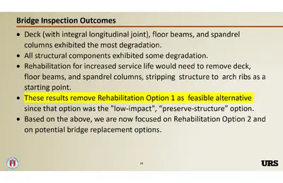
D-2 - Initial US Army Corps of Engineers Meeting – Nov. 2022 D-3 - Section 106 Evaluation – January 2023 SECTION 106 EFFECTS ASSESSMENT OF THE BARTON SPRINGS ROAD BRIDGE CITY OF AUSTIN TRAVIS COUNTY, TEXAS January 2023 Section 106 Effects Assessment of the Barton Springs Road Bridge, Austin, Travis County, Texas Prepared by: Kurt Korfmacher Architectural Historian and Principal Investigator And Erica Koteras Historian Consulting Firm: AmaTerra Environmental, Inc. Contact Information: 11842 Rim Rock Trail Austin, TX 78737 Telephone: (512) 329-0031 January 2023 Barton Springs Road Bridge Section 106 Evaluation ABSTRACT At the request of URS Corporation and on behalf of the City of Austin (City), AmaTerra Environmental, Inc. (AmaTerra) conducted an assessment of effect to the Barton Springs Road Bridge in Austin, Travis County, Texas. Barton Springs Road Bridge is a contributing resource to the Zilker Park Historic District, a property listed in the National Register of Historic Places (NRHP). The City proposes improvements to Barton Springs Road that would necessitate changes to the bridge, potentially including replacement of the existing bridge with a new structure. As the proposed undertaking would require permitting from the United States Army Corps of Engineers (USACE), it is subject to the requirements of Section 106 (36 CFR Part 800) of the National Historic Preservation Act (NHPA). As the City is a political entity of the State of Texas, the Antiquities Code of Texas (Texas Natural Resources Code, Title 9, Chapter 191) and its associated regulations (13 TAC 26) also apply. In October 2022, professional historians meeting the Secretary of Interior Standards conducted an evaluation of the proposed project and its potential for effect on the NRHP-listed bridge and related contributing resources to the Zilker Park Historic District per Section 106 guidelines. Zilker Park Historic District is listed in the NRHP under Criteria A and C at the local level in the areas of Architecture, Conservation, Entertainment/Recreation, and Landscape Architecture, with a period of significance of 1917-1947. Both Barton Springs Road Bridge and the Main Entrance Piers (contributing) are within the project area. The proposed bridge improvements are associated with a larger overall plan for Zilker Park known as the Zilker Park Vision Plan. This ambitious multi-year proposal would make major changes to large sections of Zilker Park to improve pedestrian flow and access, improve safety, restore and protect the natural environment, and make general improvements to how the park is accessed and operated for the long- term health of the park. Although improvements to the bridge are a component of the plan, the specific proposed improvements presented here have been developed in parallel but separately from the overall Zilker Park Vision Plan. As the improvements have utility beyond the Zilker Park Vision Plan, they are treated as a separate project from the Zilker Park Vision Plan for the purposes of this Section 106 evaluation. Due to current conditions of the bridge, previous studies have determined that restoration of the existing structure is not feasible. The proposed project would involve either rehabilitation and expansion of the existing structure, or demolition and replacement of the bridge with a new structure. Both options would result in an adverse effect to the contributing Barton Springs Road Bridge by impacting its integrity of design, materials, workmanship, and feeling. The proposed project would not physically impact the Main Entrance Piers but would result in a change of setting due to the alterations to the nearby bridge. As such, the proposed action would result in a change to the setting, design, materials, workmanship, and feeling of Zilker Park Historic District and is thus recommended as having an adverse effect to historic properties under Section 106. AmaTerra Environmental, Inc 1 Barton Springs Road Bridge Section 106 Evaluation INTRODUCTION PROJECT SUMMARY The City proposes road improvements to the Barton Springs Road Bridge and the intersection of Barton Springs Road and Azie Morton Road in Austin, Travis County, Texas (Figure 1). The Barton Springs Road Bridge geometry is functionally obsolete with respect to bike and pedestrian traffic. In addition, the bridge is un-aligned with the roadway east of the intersection of Barton Springs Road and Azie Morton Road, located immediately east of the bridge. To improve safety along the roadway for vehicles, bicycles, and pedestrians, reduce congestion and improve traffic flow along Barton Springs Road and at the Azie Morton Road intersection, and address important safety concerns regarding the functional operation and condition of the bridge, the City proposes to rehabilitate or replace the existing bridge. Due to the deteriorated condition of the existing bridge superstructure, preservation of the bridge is not feasible (see Attachment C for details on the deteriorated condition of the bridge). Barton Springs Road Bridge is considered a contributing resource to the NRHP-listed Zilker Park Historic District, and thus the project falls within the boundary of the NRHP historic district. At the request of URS Corporation and on behalf of the City, AmaTerra conducted an assessment of effect for the proposed undertaking following the requirements of Section 106 (36 CFR Part 800) of the NHPA. OBJECTIVE AND METHODS The primary objective of this project is to assess the potential effects to the NRHP contributing bridge and NRHP-listed historic district under Section 106. The technical approach for this recommendation on effect included research into the history of the Barton Springs Road Bridge and Zilker Park, examination of the proposed project activities, and an analysis of the impact of the proposed project activities on the aspects of integrity of the historic properties. Historians conducted fieldwork through survey forms and photographs, and relied on previous reports and documentation provided by URS on the condition of the Barton Springs Road Bridge and the various alternatives proposed. This data was then analyzed to produce a recommendation on potential adverse effect to historic properties under Section 106 following National Park Service guidelines for assessing effect to historic properties. AREA HISTORIC PROPERTIES The bridge and entrance piers are contributing resources to the Zilker Park Historic District. The Barton Springs Archeological and Historical District is also located within the Zilker Park Historic District, and the downstream boundary is within close proximity to the bridge. In addition to these historic properties, a review of the Texas Historical Commission (THC) Texas Historic Sites Atlas (Atlas) revealed one Registered Texas Historic Landmark (RTHL) within the study area of one-quarter mile, the IV Davis Homestead at 1610 Virginia Avenue. A supplemental review of the Texas Department of Transportation (TxDOT) Historic Resources of Texas Aggregator database (Aggregator) revealed additional contributing resources to the Zilker Park Historic District within the study area including stone walls and culverts, a picnic area, a sunken garden, the caretaker’s cottage, and a maintenance shop (Figure 2). Three City of Austin Historic Landmarks are also within the study area: Barton Springs, the Zilker Park Caretaker’s Cottage, and the IV Davis Homestead. In addition, the Umlauf Sculpture Garden and Museum is located directly to the south of the bridge along Azie Morton Road (Figure 2). AmaTerra Environmental, Inc 2 Barton Springs Road Bridge Section 106 Evaluation Figure 1. Project Location Map AmaTerra Environmental, Inc 3 Barton Springs Road Bridge Section 106 Evaluation Figure 2. Historic Properties in the Study Area AmaTerra Environmental, Inc 4 Barton Springs Road Bridge Section 106 Evaluation FIELD SURVEY METHODOLOGY The field work was conducted and supervised by an architectural historian meeting the Secretary of the Interior’s professional qualifications (as defined in 36 CFR Part 61). Physical inspection of the resources consisted of a site inspection, photographic documentation, and recording relevant construction materials and character-defining features. All information was recorded on field notes and maps. For the purposes of the survey, the APE was determined to be the project footprint. Photographic documentation included at least two photographic frames of the property from oblique angles to capture all visible sides, and any pertinent architectural detailing observed on the resource. Field data gathered included the current name, use, and function, if discernable; construction date (estimated, if unknown); architect or builder, if known; property type and subtype; architectural details and features. EVALUATION OF PROJECT EFFECT Under Section 106 of the NHPA [36 CFR Part 800.16(i)], an effect is any alteration to the characteristics of a historic property qualifying it for inclusion in or eligibility for the National Register. In practical terms, if a historic property is located within a project APE, then it is considered affected, and must be analyzed for adverse effect. An adverse effect, per Part 800.5(a)(1), is found when an undertaking may alter, directly or indirectly, any of the characteristics of a historic property that qualify the property for inclusion in the National Register in a manner that would diminish the integrity of the property's location, design, setting, materials, workmanship, feeling, or association. Examples of adverse effects include, but are not limited to, any of the following: 1. 2. 3. 4. 5. Physical destruction of or damage to all or part of the property; Alteration of a property, including restoration, rehabilitation, repair, maintenance, stabilization, hazardous material remediation and provision of handicapped access, that is not consistent with the Secretary of the Interior’s Standards for the Treatment of Historic Properties (36 CFR Part 68) and applicable guidelines; Removal of the property from its historic location; Change of the character of the property’s use or of physical features within the property's setting that contribute to its historic significance; Introduction of visual, atmospheric, or audible elements that diminish the integrity of the property's significant historic features. If analysis concludes project action would have an adverse effect on one or more historic properties, then per Part 800.6, the federal agency involved (in this case, the USACE) must explore options to avoid, minimize, or mitigate harm to the affected historic properties. Consulting parties, including SHPO, affected Native American tribes (and the Tribal SHPO), other affected federal or state agencies, and any other duly recognized public or private entities must have the opportunity to review and comment on the findings of adverse effect and any proposed measures to avoid, minimize, or otherwise mitigate harm. Upon review and resolution of any disagreement among the parties, the lead agency and consulting parties may sign a MOA covering the adverse effects and their resolution (if any). AmaTerra Environmental, Inc 5 Barton Springs Road Bridge Section 106 Evaluation HISTORIC OVERVIEW OF ZILKER PARK (The following information is a summary of the historic context presented in the 1997 NRHP nomination form for Zilker Park Historic District, included via reference.) Originally settled by William Barton in the late 1830s, Barton Springs was an area that would slowly prosper as a cattle area, to a place of industrialization, and, finally, recreational. Post-Civil War, this area was utilized for waterpower and the land was leased out to local entrepreneurs. The springs were also popular bathing areas before the 1910s when they became swimming areas. Andrew Zilker would buy 37 acres of land that surrounded the natural spring. This transaction would go on to inspire a zealous wave in the Reform Park Movement (1900-1930). The park’s development in the 1920s mirrored the concept of the movement by being 10-40 acres, having a bathing facility, sports fields, and a children’s play area (NRHP Registration Form, 18-20). Andrew Zilker’s main motivation with transforming Barton Springs and the park was to preserve its integrity as a natural resource. Before his infamous 1917 three-party transaction, there were few parks in Austin and no recreation facilities matching what the Reform Park Movement aimed to achieve. The 1920s development of the park would usher in a new wave of park departments and park policies for future park installations in Austin. In 1926, the city authorized a bond to fund the park’s expansion to 250-300 acres, and construction of the Barton Springs Park began. In 1928, the city established its first Recreation Department, and a five-year plan was curated to outline the future developments of the city’s park facilities (NRHP Registration Form, 20). This five-year plan would develop into a master plan set to preserve the natural topography and scenery of the remaining unconstructed park, which was 50-200 acres. Inspired by the park’s development and public appeal, other neighborhood parks and playgrounds were created between 1929 and 1939. During the early 1930s, pedestrian trails and roadways were added to make the park more accessible outside the local population. With programs created due to the Great Depression, enhancements such as these and funding for park employment was possible (NRHP Registration Form, 21). During the Great Depression, Four New Deal agencies and programs, as well as the National Park Service, are known to have contributed to Zilker’s development. By 1939, the park was fully developed due to the amounts of federal funding it received during the Depression era. These developments include bridle paths, separate roadways, and enhancement to other pre-existing topographical features. While both parks, Barton Springs and Zilker Park, compliment the eras they were developed in, the construction of the current Barton Springs Bath House (1947) displays Moderne characteristics, fully signifying the end of the Depression-era Park development (NRHP Registration Form, 22-24). Barton Springs Road Bridge As part of the plans to develop Zilker Park, the city solicited designs for a new bridge over Barton Creek to provide access to the park from the south bank of the Colorado River. Terrell Bartlett Engineers of San Antonio designed the new bridge in 1925, featuring three spans supported by concrete arches on concrete piers with two traffic lanes, a pedestrian sidewalk, and decorative railing with integrated light posts (Figure 3). The bridge, constructed the following year, stretched 210 feet over Barton Creek, with a 20- foot-wide roadway, 5-foot sidewalk, and curbing. AmaTerra Environmental, Inc 6 Barton Springs Road Bridge Section 106 Evaluation Figure 3: Original 1925 plans for the Barton Springs Road Bridge. The growth of Austin and the success of Zilker Park meant the amount of traffic passing over the bridge soon exceeded its capacity. In 1945, city engineers revealed plans for expanding the existing bridge by more than doubling its width to accommodate two more lanes of traffic plus an additional sidewalk on the side opposite the existing one (Figure 4). Matching the design of the existing bridge, the new bridge measured nearly 60 feet across, adding a second set of arched spans matching the original set. Today, Barton Springs Road is a four-lane road that serves as the primary thoroughfare through Zilker Park, located on the south bank of the Colorado River along Lady Bird Lake. The bridge over Barton Creek is at the east entrance to the park which serves as a focal point for important community events such as the annual Austin City Limits Music Festival, South by Southwest Conference and Music Festival (SXSW), Barton Springs, the holiday Trail of Lights, and Blues on the Green to name a few. Barton Springs Road and the bridge also serve vehicular, bicycle, and pedestrian traffic, and the road serves as a primary connector from Loop 1/Mopac Freeway to south Austin, downtown, and key corridors such as South Lamar Boulevard and Congress Avenue. AmaTerra Environmental, Inc 7 Barton Springs Road Bridge Section 106 Evaluation Figure 5. Surveyed Contributing Resource Locations. AmaTerra Environmental, Inc 9 Barton Springs Road Bridge Section 106 Evaluation RESOURCE DESCRIPTIONS Resource No. 01: Barton Springs Road Bridge The Barton Springs Road Bridge is a three-span, open spandrel concrete arch bridge originally constructed in 1925 and expanded on the north side in 1946. It is approximately 212’ long and 58’-8” wide and carries four lanes of traffic and two sidewalks across Barton Creek. The railing consists of steel frame and tube set between cast concrete chamfered posts, with integrated conduits for light posts. Metal construction plaques are embedded in end posts at both the west and east ends of the bridge. Alterations include the 1945 expansion on the northern section of the bridge and added pathways for pedestrians underneath the bridge on both banks of Barton Creek, and tracks for a miniature train on the west bank (although none of the paths connect directly to the bridge superstructure itself. Other alterations include removal of the light posts on the bridge at an indeterminate date. These changes were all present at the time the bridge was determined a contributing resource to the Zilker Park Historic District and do not detract from the bridge’s integrity of location, design, setting, materials, workmanship, feeling, and association. Resource No. 02: Zilker Park Main Entrance Piers The Zilker Park Main Entrance Piers are two monuments and associated stone walls and planters that flank the east end of Barton Springs Road just west of the bridge. The primary south pier is a large monument with Art Deco styling. The monument is constructed of yellowed Cordova limestone quarried locally set in semi-regular courses, with decorative bands and overhangs. The words “ZILKER PARK” are lettered in iron on either side of the monument. A large limestone planter extends out from the base and to the east toward the bridge. The north side entrance pier is much smaller than the south pier (approximately one-third the height) and features more modest Art Deco styling, topped by a flat concrete cap. A limestone planter extends out to the east from the north pier, similar to the south pier. The piers have no obvious alterations and retain integrity of location, design, setting, materials, workmanship, feeling, and association. The TxDOT Aggregator separates the planters and walls from the entrance piers as contributing resources to the historic district. However, as the NRHP nomination treats them as part of the entrance piers, the piers and planters were evaluated as a single resource for this study. Resource No. 03: Stone Culvert Resource No. 03 is a small stone culvert laid out on a north-south axis underneath Barton Springs Road west of the entrance piers. The culvert is made of rough-cut sandstone and concrete, with a stone head wall set back from the road, angled stone wing walls, and a simple cast concrete pipe. A modern stone skirt is set in the ground between the head wall and the roadway. The culvert is listed as a contributing resource on the TxDOT Aggregator but is not recorded as a contributing resource in the Zilker Park Historic District NRHP nomination form. It is treated as an eligible contributing resource for the purposes of this study, with integrity of location, design, setting, materials, workmanship, feeling, and association. AmaTerra Environmental, Inc 10 Barton Springs Road Bridge Section 106 Evaluation SECTION 106 EFFECTS ANALYSIS PROPOSED PROJECT ACTIVITIES The age and deteriorated condition of the bridge have warranted increased inspections over time, and the bridge geometry is functionally obsolete with respect to bike and pedestrian traffic. A bridge inspection was last performed in 2017. In addition, the bridge is un-aligned with the roadway east of the intersection of Barton Springs Road and Azie Morton Road, located immediately east of the bridge. To improve safety along the roadway for vehicles, bicycles, and pedestrians, reduce congestion and improve traffic flow along Barton Springs Road and at the Azie Morton Road intersection, and address important safety concerns regarding the functional operation and condition of the bridge, the City proposes to rehabilitate or replace the existing bridge and construct improvements to the associated bike paths, sidewalks, and the intersection of Barton Springs Road and Azie Morton Road (Attachment B). Due to the deteriorated condition of the existing bridge superstructure, preservation of the bridge is not feasible (Attachment C). Option One: Bridge Rehabilitation Rehabilitation would require removal of the existing bridge deck and spandrel columns, and then attempt to repair and reuse the existing concrete arches with the new columns and deck. Additional arches would also be needed to expand the bridge to approximately 109 feet in width in order to accommodate additional bike and pedestrian capacity and turn lanes to improve traffic flow at the Azie Morton Road intersection. The arches of the expanded bridge would match the existing bridge, although less than half of the original bridge would remain. Option Two: Bridge Replacement Replacement of the bridge would remove the existing bridge entirely and construct a new structure with sufficient width (approximately 109 feet) to accommodate the proposed multi-modal travel ways. The design of the replacement bridge is still under consideration and multiple alternatives are under development. ANALYSIS OF ADVERSE EFFECT Project historians used the results of the field survey, the information contained within the Zilker Park Historic District NRHP nomination form, the proposed project activities, and guidelines provided by the National Park Service to determine the level of effect on the NRHP listed properties within the project APE. Table 2 summarizes the recommendations on effect. Option One: Bridge Rehabilitation Under the rehabilitation option, the existing bridge deck and spandrel columns would be replaced, and the existing concrete arches would be used to support the new deck. In addition, the bridge would be expanded to accommodate added traffic lanes and pedestrian pathways. While the addition would mimic the appearance of the existing bridge, the change in size would impact the bridge’s integrity of design and feeling. Removal and replacement of the spandrel columns would impact the integrity of materials and workmanship. With impacts to integrity of design, materials, workmanship, and feeling, it is recommended that the proposed rehabilitation option would have an adverse effect on the NRHP contributing bridge under Section 106. AmaTerra Environmental, Inc 11 Barton Springs Road Bridge Section 106 Evaluation References Cited National Register of Historic Places 1997 “Zilker Park Historic District.” National Register of Historic Places Nomination Form, prepared by Julie Strong, et. al., Heritage Marketing, Austin. AmaTerra Environmental, Inc 13 Barton Springs Road Bridge Section 106 Evaluation APPENDIX A: HISTORIC RESOURCES SURVEY FORMS AmaTerra Environmental, Inc 14 Barton Springs Road Bridge Historic Resources Survey December 2022 Surveyed by Kurt Korfmacher and Erica Koteras Resource No. 01 Address: Barton Springs Rd at Barton Creek Resource Type: Structure Function/Use: Transportation/road-related (vehicular) Estimated Year built: 1926/1946 References: NRHP Nomination Form; bridge plaque NRHP Eligibility: Contributing resource of Zilker Park Historic District which is listed under Criteria A and C at the local level in the areas of Architecture, Conservation, Entertainment/Recreation, and Landscape Architecture, with a period of significance of 1917-1947. Description: The existing bridge is a three-span, open spandrel concrete arch bridge originally constructed in 1926 and expanded on the north side in 1946. It is approximately 212’ long and 58’-8” wide and carries four lanes of traffic and two sidewalks across Barton Creek. Alterations include an added structure in the northern section of the bridge. The bridge is considered a contributing resource to the NRHP-listed Zilker Park Historic District under Criteria A and C. It contributes to the urban and historic fabric of Zilker Park and is an integral public transportation system in Austin, Texas. Camera direction: south AmaTerra Environmental, Inc 15 Resource No. 01 Address: Barton Springs Rd at Barton Creek Camera direction: east Camera direction: west AmaTerra Environmental, Inc 16 Resource No. 01 Address: Barton Springs Rd at Barton Creek Camera direction: southeast Camera direction: north AmaTerra Environmental, Inc 17 Resource No. 01 Address: Barton Springs Rd at Barton Creek Camera direction: northeast Camera direction: east AmaTerra Environmental, Inc 18 Resource No. 01 Address: Barton Springs Rd at Barton Creek Camera direction: southeast Camera direction: southwest AmaTerra Environmental, Inc 19 Resource No. 01 Address: Barton Springs Rd at Barton Creek Camera direction: southwest Camera direction: southeast AmaTerra Environmental, Inc 20 Barton Springs Road Bridge Historic Resources Survey November 2022 Surveyed by Kurt Korfmacher and Erica Koteras Resource No. Resource Type: 02 Object Address: 2207 Lou Neff Rd Function/Use: Landscape/Monument Estimated Year built: 1934 References: NRHP Nomination Form NRHP Eligibility: Contributing resource of Zilker Park Historic District which is listed under Criteria A and C at the local level in the areas of Architecture, Conservation, Entertainment/Recreation, and Landscape Architecture, with a period of significance of 1917-1947. Description: The Zilker Park Main Entrance Piers are found at the entrance to the park, west of the Barton Springs Road Bridge. The monument is constructed of yellowed Cordova limestone quarried locally, set in semi-regular courses, with decorative bands and overhangs. The words “ZILKER PARK” are lettered in iron on either side of the monument. The north side entrance pier is much smaller than the south pier (approximately one-third the height) and features more modest Art Deco styling, topped by a flat concrete cap. The entrance piers are considered contributing resources to the NRHP-listed Zilker Park Historic District under Criteria A and C. They contribute to the urban and historic fabric of Zilker Park. Camera direction: southwest looking at north entrance pier AmaTerra Environmental, Inc 21 Resource No. 02 Address: 2207 Lou Neff Rd Camera direction: west Camera direction: southwest AmaTerra Environmental, Inc 22 Resource No. 02 Address: 2207 Lou Neff Rd Camera direction: northeast Camera direction: northwest AmaTerra Environmental, Inc 23 Resource No. 02 Address: 2207 Lou Neff Rd Camera direction: southeast Camera direction: northwest looking at north entrance pier AmaTerra Environmental, Inc 24 Resource No. 02 Address: 2207 Lou Neff Rd Camera direction: north AmaTerra Environmental, Inc 25 Barton Springs Road Bridge Historic Resources Survey November 2022 Surveyed by Kurt Korfmacher and Erica Koteras Resource No. 03 Address: 2207 Lou Neff Rd Resource Type: Structure Function/Use: Transportation/Culvert Estimated Year built: C. 1934 References: NRHP Nomination Form; TxDOT Aggregator NRHP Eligibility: Considered contributing to the Zilker Park Historic District under Criteria A and C at the local level in the areas of Architecture, Conservation, Entertainment/Recreation, and Landscape Architecture. Description: The culvert bridge runs under the road just west of the Zilker Park Entrance Piers. It is made of rough-cut sandstone and concrete, with a stone head wall set back from the road, angled stone wing walls, and a simple cast concrete pipe. A modern stone skirt is set in the ground between the head wall and the roadway. It is listed as a contributing resource on the TxDOT Aggregator but is not recorded as a contributing resource in the Zilker Park Historic District NRHP nomination form. It is treated as a contributing resource for the purposes of this study. Camera direction: northwest AmaTerra Environmental, Inc 26 Resource No. 03 Address: 2207 Lou Neff Rd Camera direction: west AmaTerra Environmental, Inc 27 Barton Springs Road Bridge Section 106 Evaluation APPENDIX B: PRELIMINARY PLANS AmaTerra Environmental, Inc 28 Barton Springs Road Bridge Section 106 Evaluation APPENDIX C: CITY OF AUSTIN REHABILITATION VS. REPLACEMENT MEMORANDUM AmaTerra Environmental, Inc 30 City of Austin Barton Springs Road Bridge over Barton Creek Rehabilitation vs. Replacement Memorandum CIP ID 5873.031 URS Corporation 9400 Amberglen Blvd. Austin, TX 78729 (512) 419-5897 TX Firm F-3162 7650 W. Courtney Campbell Cswy. Tampa, FL 33607-1462 (813) 286-1711 September 28, 2022 Final (F1) This document is released under the authority of Robert B. Anderson Texas PE No. 111066 Barton Springs Road Bridge over Barton Creek Rehab vs. Replacement Memo REVISIONS Project: City of Austin – Barton Springs Road Bridge over Barton Creek Document: Rehab vs. Replacement Memo Revision Date of Issue Description D0 D1 D2 F1 08/22/2022 Draft Issue for Internal Comment 09/12/2022 Revised Draft Issue post PWD comments 09/19/2022 Revised Draft Issue cost table and replacement comparison 09/28/2022 Final Issue Contents 1. 2. 3. INTRODUCTION............................................................................................ 3 Purpose and Need .................................................................................. 3 1.1 Bridge Cultural / Historical Background / Existing Condition ......................... 3 1.2 DESIGN CONCEPTS ....................................................................................... 5 Design Elements Common to Both Rehabilitation and Replacement .............. 5 2.1 Rehabilitation Option .............................................................................. 5 2.2 Replacement Option ............................................................................... 7 2.3 COMPARISON OF PRELIMINARY REPLACEMENT / REHABILITATION CONCEPTS .................................................................................................. 10 4. SUMMARY AND RECOMMENDATIONS ......................................................... 12 Statement of Limitations This report is intended for the City of Austin and is distributed to third parties outside the City’s organization, with their consent. This interim memo provides a direct comparison between the rehabilitation and replacement options for the Barton Springs Road Bridge over Barton Creek and provides a recommendation from the design team. This report is intended to outline the current design approach and highlight the pros and cons associated with the rehabilitation and replacement concepts. To limit the size and focus of this memo, the detailed work associated with existing bridge inspection and preliminary concept development and analysis are incorporated by reference. Page 2 of 13 Barton Springs Road Bridge over Barton Creek Rehab vs. Replacement Memo 1. INTRODUCTION This section of the report summarizes the purpose and need for the project and provides some Cultural and Historical Background. 1.1 Purpose and Need The purpose and need for this project is centered on safety-related bridge improvements that address the following items: Insufficient bike / pedestrian paths (functionally obsolete); Age of structure / structural degradation; Bridge roadway lanes not aligned with lanes east of Azie Morton; Hillside instability (rock fall) and obsolete retaining wall on Azie Morton east side at intersection; Elevated / overhanging sidewalk integral to intersection – past movement / cracking; and Bridge / intersection congestion. 1.2 Bridge Cultural / Historical Background / Existing Condition The original Barton Springs Road bridge was built in 1925 and widened to its current configuration in 1945. The bridge is located adjacent to Zilker Park, which is listed in the National Register of Historic Places (NRHP); and is considered a contributing resource to the Park. The Barton Springs Archeological and Historical District (formed in 1985) is also located within the Zilker Historic District and the downstream boundary of this district is in close proximity to the bridge. The age of the south and north structures is 97 and 76 years, respectively. The bridge overall has a condition rating of "Fair," and most structural components generally have a condition rating of “Good”, based on the FHWA Condition Rating Guidelines. Given the advanced age of the deck, and the fact that the most serious deterioration is found within the vicinity of the longitudinal deck joint, it is necessary to replace the deck entirely and eliminate the longitudinal joint and transverse joints where practical. This precludes efforts to keep and repair all of the existing bridge components. In addition, the spandrel columns exhibit low concrete compressive strength and severe cracking, spalling, and/or delamination (2017 On-Site Sampling and Laboratory Investigation). The cracking of the shorter spandrel columns is further exacerbated by their structural configurations (moment connections at both the top and bottom), which attract an inordinately large amount of shear loading. Therefore, any proposed bridge rehabilitation strategy that provides a substantial increase in service life requires “stripping” the structure down to the arch ribs and reconstructing the spandrel columns, floor system, and deck. Sliding bearings at the tops of the new spandrel columns will decouple the deck from the supporting structure. Page 3 of 13 Barton Springs Road Bridge over Barton Creek Rehab vs. Replacement Memo Figure 1. Deterioration of Longitudinal Beam In addition to the condition of the existing bridge, the site presents a number of challenges and constraints. Many of these are illustrated in the issues map below: Figure 2. Barton Springs Rd. Bridge Challenges and Constraints Page 4 of 13 Barton Springs Road Bridge over Barton Creek Rehab vs. Replacement Memo 2. DESIGN CONCEPTS 2.1 Design Elements Common to Both Rehabilitation and Replacement Barton Springs Road serves as a vital roadway connector. Improvements include the realignment of the travel lanes to improve or eliminate the current offset movement at the Azie Morton Road interchange. The bridge provides a vital bicycle and pedestrian link to the Zilker Park and the existing bike/ pedestrian facilities are inadequate. The redesigned bridge provides dedicated bike lanes as well as a 14 ft. wide sidewalk on the south side of the bridge and an 18 ft. wide shared use path on the north side of the bridge. The design also links the sidewalks to the park trail system and accommodates the trails underneath the bridge. Lastly, the design will maintain space for the “Zilker Eagle” train that will be refurbished in the near future. Both the rehabilitation scheme and the replacement scheme share the same above- deck configuration, resulting in an overall bridge width increase from 59 ft. to 109 ft. Therefore, either approach will provide the same result with respect to traffic and bike/ pedestrian movements. Figure 3. Bridge and Roadway Proposed Geometric Plan 2.2 Rehabilitation Option The Rehabilitation Option will reuse portions of the existing bridge structure (with rehabilitation measures implemented) and widen each side to provide the ultimate width necessary for proposed multi-modal travel ways. Page 5 of 13 Barton Springs Road Bridge over Barton Creek Rehab vs. Replacement Memo Due to the deterioration of the existing bridge, only the existing arch ribs will remain. Figure 4. Bridge Rehabilitation – Remove Deck and Spandrel Columns; Remediate Remaining Structures Once the arches are exposed, work will include reinforcement of the existing abutments, repairs to the arches and installation of a cathodic protection system to reduce further deterioration of the steel rebar in the arch ribs. Four additional lines of arch ribs will be added to accommodate the wider deck above. Therefore, the existing arch ribs will only be visible when viewed from underneath the structure. Figure 5. Install New Arch Ribs, Spandrel Columns and Extend Abutments The fully rehabilitated bridge will maintain the overall appearance and configuration of the existing bridge, utilizing similar details for the arches, spandrel columns, longitudinal beams, etc. In accordance with current design practices, it is anticipated that the level of remediation and future corrosion mitigation methods will be employed to achieve an additional 50 to 75 years of bridge service life subsequent to the rehabilitation. Page 6 of 13 Barton Springs Road Bridge over Barton Creek Rehab vs. Replacement Memo While the rehabilitation option will provide the appearance of keeping the existing bridge, less than half of the original structure will remain intact and very little surficial materials will remain. Furthermore, very little of the original structure will be plainly visible after the new rib extensions on both sides and the installation of new spandrel columns and deck. As such, what will be predominantly in view is new bridge structure and materials. Figure 6. Rehabilitation Option Rendering 2.3 Replacement Option The Replacement Option will remove the existing bridge structure in its entirety and provide a new structure with the ultimate width necessary for proposed multi-modal travel ways. This option allows for lengthening the bridge by moving the western abutment to the west. In so doing, the Replacement Option provides additional space to facilitate improvements to existing Zilker Park facilities, such as walking paths and the Zilker Eagle miniature railroad, both of which pass under the Barton Springs Road Bridge on the west bank. This additional space for improvements is not feasible with the Rehabilitation Option. A number of design options for the replacement bridge were developed and vetted with the City of Austin and various stakeholders. Table 2-1 provides a summary of the comparison of rehabilitation options. Page 7 of 13 Barton Springs Road Bridge over Barton Creek Rehab vs. Replacement Memo historic impact avoidance and historic impact minimization are simply not possible. Therefore, the focus of the investigation has centered on the development of feasible restoration and replacement schemes that meet the current transportation demands while providing a structure with a lifespan of at least 75 additional years of service. Both rehabilitation and replacement can accommodate the transportation needs in a similar fashion. The replacement scheme offers numerous additional benefits (highlighted cells in the above table) including better accommodations of the Zilker Eagle mini-train and enhanced trails underneath the bridge. The most significant differences between the rehabilitation scheme and the replacement scheme are cost and risk. The particular replacement bridge alternative selected is not the least expensive design possible, it includes enhanced features such as unique piers and upgraded abutments. Even with these enhancements, the cost of the replacement bridge is 40% less than the rehabilitation scheme. Furthermore, ongoing maintenance cost and labor requirements are less with the replacement scheme. There is also a great deal of risk associated with the rehabilitation scheme. While the bridge condition survey was thorough, there are many things that could increase the cost of rehabilitation once the initial demolition exposes all of the “hidden” elements of the bridge. We understand the significance of the existing bridge and the importance of preserving historical assets. However, as stewards of the taxpayer’s money there is an obligation to make the best value decision for the community. If the bridge is rehabilitated, very little of the existing structure will remain and those remaining elements will be almost entirely concealed by the new construction. This fact coupled with the significant increase in cost and risk leads the design team to recommend replacement as the path forward. The project is continuing an on-going coordination with the Texas Historical Commission (THC); and it is intended that input from both the THC and U.S. Army Corps of Engineers will be forthcoming as coordination continues. Page 13 of 13 D-4 - THC Review of Section 106 Evaluation – March 2023 We look forward to further consultation with your office and hope to maintain a partnership that will foster effective historic preservation. Thank you for your cooperation in this review process, and for your efforts to preserve the irreplaceable heritage of Texas. If the project changes, or if new historic properties are found, please contact the review staff. If you have any questions concerning our review or if we can be of further assistance, please email the following reviewers: tiffany.osburn@thc.texas.gov, amy.borgens@thc.texas.gov, alex.toprac@thc.texas.gov, caitlin.brashear@thc.texas.gov. This response has been sent through the electronic THC review and compliance system (eTRAC). Submitting your project via eTRAC eliminates mailing delays and allows you to check the status of the review, receive an electronic response, and generate reports on your submissions. For more information, visit http://thc.texas.gov/etrac-system. Sincerely, M m m for Mark Wolfe, State Historic Preservation Officer Executive Director, Texas Historical Commission Please do not respond to this email. cc: SETH.SAMPSON@usace.army.mil,Jennifer.R.Walker2@usace.army.mil,alexander.shane@thc.texas.gov,Elizabeth.Brumm ett@thc.texas.gov</p 2 Appendix E – Public Engagement E-1 - Open House – April 2023 E-1 - Open House Virtual Power Point