13.1 - 4200 Wilshire Pkwy - Approved Land Status Determination — original pdf
Backup
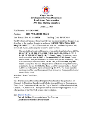
City of Austin Development Services Department Land Status Determination 1995 Rule Platting Exception June 13, 2024 File Number: C8I-2024-0092 Address: 4200 WILSHIRE PKWY Tax Parcel I.D.# 0218110524 Tax Map Date: 06/13/2024 The Development Services Department Review has determined that this parcel, as described in the attached description and map, IS EXCEPTED FROM THE REQUIREMENT TO PLAT in accordance with the Land Development Code, Section 25-4-2(C), and is eligible to receive utility service. The parcel of land consists of five acres or less, and is described as being LOT 4, LESS N5FT & SE TRI, WILSHIRE PARK; LOT 3, BLOCK 4, S CEN E PART OF WILSHIRE WOOD, SEC 3, Travis County, Texas in the current deed, recorded on Mar 30, 2007, in Document #2007057101, Travis County Deed Records. This parcel existed in its current configuration on January 1,1995, as evidenced by a deed recorded on Jun 26, 1984, in Volume 8668, Page 591, Travis County Deed Records. The parcel was lawfully receiving utility service, as defined in Section 212.012 of the Texas Local Government Code, on January 1, 1995, as evidenced by water service on Sep 24, 1947. The parcel meets the requirements of the Land Development Code for roadway frontage and is located on an existing street. Additional Notes/Conditions: NONE This determination of the status of the property is based on the application of Chapter 212, Municipal Regulation of Subdivisions and Property Development, Texas Local Government Code; and the City of Austin Land Development Code, Chapter 25-4, Subdivision. Recognition hereby does not imply approval of any other portion of the City Code or any other regulation. By: _Patrick Collins_____________________________________ Patrick Collins, Representative of the Director Development Services Department Tax Parcel I.D.# 0218110524 Tax Map Date: 06/13/2024