6.2 - 200 E 43rd St - Existing Site Plan — original pdf
Backup
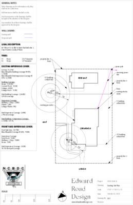
TREES: T1 Pecan T2 Pecan 25.5" diameter 23" diameter property line + fence GENERAL NOTES: These drawings are for information only, they shall not be scaled from. All dimensions shall be checked on site. Any discrepancies in the drawings shall be brought to the attention of the designer. Any variations from these drawings shall be approved by the designer. WALL LEGEND: Existing wall: Proposed wall: LEGAL DESCRIPTION: W 75ft Lot 12-16 Blk 16 Hyde Park Addn No 1, City of Austin, County of Travis EXISTING IMPERVIOUS COVER: Lot Area: 9,375t2 Max Allowable Building Coverage @ 40%: 3,750ft2 Max Allowable Total Impervious Coverage @ 45%: 4,218ft2 Building Coverage: House: 1,591ft2 Covered Porch: 152ft2 Cottage: 605ft2 Cottage Porch: 112ft2 Total Building Coverage: 2,460ft2 26% lot coverage Impervious Coverage: Walkway + Steps: 238ft2 Planter: 22ft2 Cottage Planter: 9ft2 Total Impervious Coverage: 269ft2 2.9% lot coverage Total Building + Impervious Coverage: 2,729ft2 / 29.1% FRONT YARD IMPERVIOUS COVER: Front Yard Area: 1,875ft2 Max Allowable Coverage @ 40%: 750ft2 Impervious Coverage: Front Porch: 152ft2 Walkway + Steps: 158ft2 House: 33ft2 Total Impervious Coverage: 343ft2 18.3% front yard coverage 15' building setback line 4303 ave f R 6' 4.5" 1/4 C R Z T1 R12' 9" 1/2CRZ R25' 6"CRZ existing gas meter ave f 200 e43rd st T2 " R Z R 5 ' 9 C 1 / 4 R11' 6" 1/2CRZ R23' 0"CRZ e 43rd st power pole incoming power line property line + fence fence existing electric meter 5' building setback line 25' building setback line property line + fence SCALE: N t f 0 t f 5 t f 0 1 t f 0 2 t f 0 3 www.edwardroaddesign.com Revision Project 200 E 43rd St Drawing Existing Site Plan Scale Date 1/16" = 1' @ 11 x 17 October 03, 2022 Drawing No. 001