D.4.5 - 201 W 30th St - Survey form — original pdf
Backup
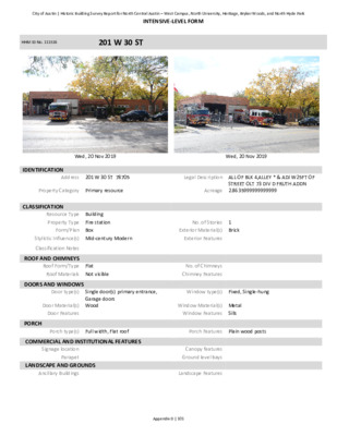
INTENSIVE‐LEVEL FORM HHM ID No. 111516 201 W 30 ST Wed, 20 Nov 2019 Wed, 20 Nov 2019 Address 201 W 30 ST 78705 Legal Description ALL OF BLK 4,ALLEY * & ADJ W25FT OF STREET OLT 73 DIV D FRUTH ADDN Acreage 2.8635999999999999 IDENTIFICATION Property Category Primary resource CLASSIFICATION Resource Type Building Property Type Fire station Form/Plan Box Stylistic Influence(s) Mid‐century Modern Classification Notes ROOF AND CHIMNEYS Roof Form/Type Flat Roof Materials Not visible DOORS AND WINDOWS Door type(s) Single door(s) primary entrance, Garage doors Door Material(s) Wood Door Features PORCH Porch type(s) Full width, Flat roof COMMERCIAL AND INSTITUTIONAL FEATURES Signage location Parapet LANDSCAPE AND GROUNDS Ancillary Buildings No. of Stories 1 Exterior Material(s) Brick Exterior Features No. of Chimneys Chimney Features Window type(s) Fixed, Single‐hung Window Material(s) Metal Window Features Sills Porch Features Plain wood posts Canopy features Ground level bays Landscape Features City of Austin | Historic Building Survey Report for North Central Austin – West Campus, North University, Heritage, Bryker Woods, and North Hyde ParkAppendix D | 101 201 W 30 ST Page 2 Source Year Built Austin American‐Statesman, 20 Jul 1956, Builder Occupant History 1954/55: Not listed; 1959/60: Fire Dept Station No 3; 1965‐70: Follow up ‐ Pending AHC Reopening HHM ID No. 111516 HISTORY Current Name Fire Station No. 3 Current Use Governmental Year Built 1956 Associated People History Notes Other historical sources p. 20 INTEGRITY Alterations Additions PRIOR DOCUMENTATION Designations Prior Survey Data Historic Name Historic Use Governmental Architect Roy L. Thomas Relocation Notes LOCAL RECOMMENDATIONS Recommendation Local landmark Justification Possesses integrity and significance NATIONAL REGISTER (NRHP) RECOMMENDATIONS Recommendation Individually eligible Justification Possesses integrity and significance District Name N/A Status (N/C) N/A Criteria Architecture, Historical Associations (Section 5.1.5.5. Postwar Infrastructure Expansion) District Name N/A Status (N/C) N/A Criteria A, C Area of Significance Level of Significance Community Planning and Development, Architecture Local OTHER RECOMMENDATIONS Tourism Tag City of Austin | Historic Building Survey Report for North Central Austin – West Campus, North University, Heritage, Bryker Woods, and North Hyde ParkAppendix D | 102 City of Austin | Historic Building Survey Report for North Central Austin West Campus, North University, Heritage, Bryker Woods, and North Hyde Park For some older sections in the project area, like North University, the 1940s and 1950s represented a period of relative decline. Since the GI Bill focused on new construction, these neighborhoods did not benefit from an infusion of new funds. New construction occurred on available empty lots, particularly in the North Hyde Park district, where remaining large estate lots were subdivided, or where older houses were demolished (for more information, see the North Hyde Park Historic District in Section 5-8). In established subdivisions throughout the survey area, many of the new homes reflected postwar architecture like the Ranch style (fig. 5-1-29). Examples of Ranch-style infill development include 1202 West 29th Street, 2903 Oakhurst Avenue, and 1301 Belmont Parkway. Particularly in areas closer to the university, like the North University neighborhood, apartment buildings represented a significant portion of new construction. 5.1.5.6. Postwar Infrastructure and Public Expansion Austin’s population growth in the postwar period fueled expanded infrastructure investments. Within the project area, infrastructure expansion included healthcare and transportation projects. Beginning in the 1950s, the Austin State Hospital began expansion efforts to address serious overcrowding of its mental health patients, a statewide problem. With the last significant building campaign ending in 1937, the Austin State Hospital, using state legislature monies, erected the General Medical and Surgical Building (900 West 38th Street) in 1955. The new building provided 250 additional beds as well as increased capacity for nursing, surgical and psychiatric care. Despite the addition of hospital and administrative buildings in subsequent years, mental health care continued to lag due to inadequate funding. Transportation improvements in the project area included the 1946 concrete Speedway Street Bridge, which spanned West Waller Creek (2900 Speedway Street). The medical node along West 34th Street also took shape during this period. In 1965, the city council approved a multimillion-dollar medical complex on Shoal Creek between 34th and 38th Streets, with Seton spending more than $8 million to build a new hospital and the Austin Doctors Corporation spending another $3 million on additional medical facilities. “As a safeguard, however,” the Austin American-Statesman reported, “the council accepted terms for vacating streets in the area for ‘hospital use only’” with no other types of development permitted. As part of the agreement, the Austin Doctors Corporation deeded Shoal Creek to the City and paid to develop a public park and bike and hiking trail.65 Part of the city’s rapidly developing medical node included the new Austin Diagnostic Clinic at 801 West 34th Street and Seton Hospital at 3501 Mills Avenue. 5.1.5.7. Mid-century Religious and Cultural Nodes The postwar period also saw an expansion of religious and cultural institutions. Much of this growth occurred near the university, which saw dramatic physical and student growth following World War II. City directories beginning in 1935 and continuing into the 1950s, reveal a large number of reverends living in the university area. Just as the area saw the development of numerous religious institutions prior to the war, religious organizations continued to erect churches to facilitate students’ religious needs. Two circa 1960 churches (1909 and 2007 University Avenue) reflect the trend of religious institutional development in the university area in the postwar period. Cultural development in the postwar period was greatly influenced by the university. The Drag continued to serve as a primary cultural location for students and included restaurants, coffee shops, bookstores, and theaters. One prominent example was the Varsity Theater (2402 Guadalupe Street) which served as a movie house for university students. 5 | Historic Context – Overview 128