1 - Guadalupe Storm Drain Improvement - Memo — original pdf
Backup
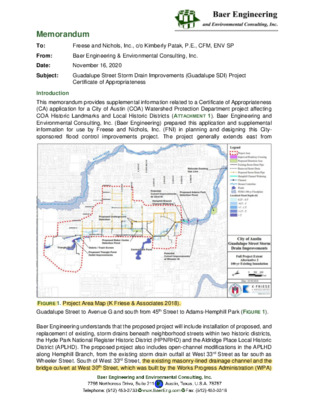
Memorandum To: From: Date: Subject: Introduction Freese and Nichols, Inc., c/o Kimberly Patak, P.E., CFM, ENV SP Baer Engineering & Environmental Consulting, Inc. November 16, 2020 Guadalupe Street Storm Drain Improvements (Guadalupe SDI) Project Certificate of Appropriateness This memorandum provides supplemental information related to a Certificate of Appropriateness (CA) application for a City of Austin (COA) Watershed Protection Department project affecting COA Historic Landmarks and Local Historic Districts (ATTACHMENT 1). Baer Engineering and Environmental Consulting, Inc. (Baer Engineering) prepared this application and supplemental information for use by Freese and Nichols, Inc. (FNI) in planning and designing this City- sponsored flood control improvements project. The project generally extends east from FIGURE 1. Project Area Map (K Friese & Associates 2018). Guadalupe Street to Avenue G and south from 45th Street to Adams-Hemphill Park (FIGURE 1). Baer Engineering understands that the proposed project will include installation of proposed, and replacement of existing, storm drains beneath neighborhood streets within two historic districts, the Hyde Park National Register Historic District (HPNRHD) and the Aldridge Place Local Historic District (APLHD). The proposed project also includes open-channel modifications in the APLHD along Hemphill Branch, from the existing storm drain outfall at West 33rd Street as far south as Wheeler Street. South of West 33rd Street, the existing masonry-lined drainage channel and the bridge culvert at West 30th Street, which was built by the Works Progress Administration (WPA) TYPE NRHP-listed NRHP-listed NRHP-listed NRHP-listed; COA Historic Landmark NRHP-listed; COA Historic Landmark Landmark COA Historic Landmark COA Historic Landmark Freese and Nichols, Inc.: 202001-8i.011 Guadalupe SDI, Certificate of Appropriateness Memo November 16, 2020 Page 2 in the 1930s, will not be removed, modified, or expanded. The proposed project will include outfalls at the Triangle Pond and at the Central Park Pond east of Guadalupe Street as well as detention ponds just west of former Robbins High School at 3900 Avenue B and in Adams- Hemphill Park south of West 30th Street (FIGURE 1). In addition to the two historic districts, the following individually designated historic properties listed in Table 1 are located adjacent to the proposed street segments of the Guadalupe SDI project. Table 1. Historic Properties adjacent to the project area HISTORIC PROPERTY NAME LOCATION DESIGNATION Robert H. and Edith Ethel McCauley House F. T. and Belle Ramsey House Hyde Park Presbyterian Church 4415 Avenue A 4412 Avenue B 3915 Avenue B Oliphant-Walker House 3900 Avenue C Rev. Henry M. and Jennie Sears House 209 West 39th Street Confederate Woman's Home 3710 Cedar Street COA Historic Simms House 212 W 33rd Street Dr. Walter Bacon Black House 401 W 32nd Street Proposed Project Plans FIGURES 2 and 3 illustrate the selected routes of proposed storm drain improvements within the HPNRHD (FIGURE 2) and the open-channel improvements along Hemphill Branch (FIGURE 3). Within the HPNRHD, and along West 34th Street and Hemphill Park in the APLHD, the proposed stormwater drain improvements will be constructed within existing City-owned right of way (ROW), beneath existing paved city streets. From the West 33rd Street stormwater outfall to West 32nd Street, the project will remove and enlarge the headwall of the West 33rd Street outfall culvert and modify the northernmost segment of the Hemphill Branch drainage channel, which is an integral landscape element of the APLHD. The proposed project will potentially remove and enlarge two historic bridge culverts at West 32nd Street and Wheeler Street (FIGURE 4). Existing condition photographs taken in October and November 2020 (ATTACHMENT 2) provide typical representative views of the affected streets, bridge-culverts, and landscapes within the HPNRHD and APLHD. Previous Historic Preservation Staff Coordination and Public involvement A Preliminary Engineering Report (PER) for the proposed project, prepared by K. Friese & Associates in 2019, includes a memorandum documenting a December 2018 conceptual review meeting with the City of Austin’s Historic Preservation staff. City Historic Preservation staff advised that the open-channel portion of the project along Hemphill Branch, including the West 33rd Street storm drain outfall, the West 32nd Street bridge-culvert, and the Wheeler Street bridge-culvert, would affect character-defining contributing elements of the APLHD that may not be removed. City Historic Preservation staff further indicated that that any alterations to those character-defining elements for flood control reasons should be kept to a minimum and that the final project design must be approved by the City Historic Landmark Commission through a CA Baer Engineering and Environmental Consulting Inc. Sustainability through Responsible Engineering of the Built Environment™ Freese and Nichols, Inc.: 202001-8i.011 Guadalupe SDI, Certificate of Appropriateness Memo November 16, 2020 Page 3 review process. The PER documents a public meeting held in October 2017 to collect prior flood impact data from property owners in the affected neighborhoods. FIGURE 3. 30 % Project Plan Sheet 2 of 2 (K. Friese & Associates 2018). Baer Engineering and Environmental Consulting Inc. Sustainability through Responsible Engineering of the Built Environment™ Freese and Nichols, Inc.: 202001-8i.011 Guadalupe SDI, Certificate of Appropriateness Memo November 16, 2020 Page 4 Current CA Application Status Baer Engineering contacted the City Historic Preservation Office staff in October 2020 to request further guidance on coordinating the project with the City’s Office of Historic Preservation and the City Landmarks Commission. City Historic Preservation staff declined to schedule a preliminary application review meeting and again recommended a CA application be submitted for staff review. This memo and the attached CA application have been prepared accordingly for submission to the City’s Historic Preservation staff, though the current 30% project plans from the 2019 PER, including preliminary plans for the Hemphill Branch modifications south of West 33rd Street and potential historic culvert replacements at West 33rd Street and Wheeler Street, may require further development to achieve final COA Landmark Commission approval. Recommended Historic Preservation Actions To assist the project engineering team in its preparation of final project plans, as required to accompany a formal CA application submission to City Historic Preservation staff, Baer Engineering recommends the following historic preservation considerations be integrated into the project plans. Baer Engineering and Environmental Consulting Inc. Sustainability through Responsible Engineering of the Built Environment™ Freese and Nichols, Inc.: 202001-8i.011 Guadalupe SDI, Certificate of Appropriateness Memo November 16, 2020 Page 5 Sub-Surface Drainage Improvements The proposed drainage improvements within HPNRHD and adjacent to the individually designated historic resources listed above should be designed to ensure all construction activities, including temporary construction equipment and materials staging areas, are limited to the existing City-owned ROW. Where existing city streets are excavated to install new or replacement sub-surface storm drains, the street surface should be replaced with asphalt paving materials similar in appearance to the existing street surface (see Photo 1 through 4, ATTACHMENT 2). Where traffic-controlling round-a- bouts have been installed at street intersections, they should be reconstructed along with landscaping to match existing conditions at those intersections (see Photo 3, ATTACHMENT 2). Special attention should be given to avoiding impacts, temporary or otherwise, to all of the concrete “Hyde Park” neighborhood markers and concrete street sign posts that occur at street intersections, typically located close behind existing street curbs (see Photo 2, ATTACHMENT 2). The proposed detention ponds located at the Robbins High School property tract, 3900 Avenue B, and the drainage outfall connections to Triangle Pond and Central Park Pond do not appear to affect any currently designated historic districts or individually designated historic properties. Open-Channel Flood Control Modifications The proposed modifications to West 33rd Street outfall (see Photo 6, ATTACHMENT 2) and Hemphill Branch within the APLHD should be designed to ensure the final project closely resembles the historic materials, design, and feeling of Hemphill Branch and Hemphill Park as those qualities currently contribute to the historic character of the APLHD landscape. As it currently exists, the open channel between West 33rd Street and West 32nd Street has sloping channel walls partially lined with irregular stone paving that has become broken and displaced by dense, uncontrolled vegetation (See Photos 7 and 8, ATTACHMENT 2). The new channel design should retain the sloping channel wall form and integrate natural stone planter boxes or terraces rather than continuous, impermeable concrete surface treatments to minimize changes in character to this aspect of the Hemphill Park landscape. The historic bridge-culverts at West 32nd and Wheeler Streets (see Photos 8 through 10, ATTACHMENT 2) should be modified rather than replaced, with the modifications designed to minimize character-altering changes in the existing form, scale, and materials, especially as those qualities are expressed in the existing railings and culvert faces. If replacement is necessary for flood control reasons, the new design should closely resemble the existing in scale, design, materials, and construction with minimal impact to the adjacent stone- lined channel walls. Additional Regulatory Compliance Considerations Baer Engineering understands that the project as currently planned does not anticipate any federal permitting, funding, or other federal involvement that would trigger additional regulatory compliance requirements regarding impacts to historic cultural resources. In the event that federal permitting of the project becomes necessary under Section 404 of the Clean Water Act and consequently under Section 106 of the National Historic Preservation Act, additional regulatory review and compliance with the U.S. Army Corps of Engineers and the Texas State Historic Preservation Officer may require additional historic preservation considerations in the form of additional state and federal agency coordination, expanded historic resource surveys, expanded effect assessments, and implementation of required mitigation measures. Baer Engineering recommends the final design of the project avoids impacts to waters of the United States that would require permitting of the project through the U.S. Army Corps of Engineers. Separate coordination with the Texas Historical Commission regarding archeological resources within the project area is being conducted. Baer Engineering and Environmental Consulting Inc. Sustainability through Responsible Engineering of the Built Environment™ Freese and Nichols, Inc.: 202001-8i.011 Guadalupe SDI, Certificate of Appropriateness Memo November 16, 2020 Page 6 Attachment 1: City of Austin Certificate of Appropriateness Application Baer Engineering and Environmental Consulting Inc. Sustainability through Responsible Engineering of the Built Environment™ Freese and Nichols, Inc.: 202001-8i.011 Guadalupe SDI, Certificate of Appropriateness Memo November 16, 2020 Page 7 Attachment 2: Representative Photos Photo 1. HPNRHD, Streetscape at West 43rd Street and Avenue A, looking East. Photo 2. HPNRHD, Neighborhood Marker at West 43rd and Avenue B, looking Southwest. Baer Engineering and Environmental Consulting Inc. Sustainability through Responsible Engineering of the Built Environment™ Freese and Nichols, Inc.: 202001-8i.011 Guadalupe SDI, Certificate of Appropriateness Memo November 16, 2020 Page 8 Photo 3. HPNRHD, Streetscape with Round-a-Bout, West 41st Street at Avenue B, looking Northeast. Photo 4. HPNRHD, Streetscape with Hyde Park Presbyterian Church (COA Historic Landmark) at West 39th and Avenue B, looking South. Baer Engineering and Environmental Consulting Inc. Sustainability through Responsible Engineering of the Built Environment™ Freese and Nichols, Inc.: 202001-8i.011 Guadalupe SDI, Certificate of Appropriateness Memo November 16, 2020 Page 9 Photo 5. APLHD, Streetscape at West 33rd and Hemphill Park, looking Northwest. Photo 6. APLHD, West 33rd Outfall Culvert at Hemphill Branch, looking North. Baer Engineering and Environmental Consulting Inc. Sustainability through Responsible Engineering of the Built Environment™ Freese and Nichols, Inc.: 202001-8i.011 Guadalupe SDI, Certificate of Appropriateness Memo November 16, 2020 Page 10 Photo 7. APLHD, Sloping Channel Wall of Hemphill Branch, Upstream from West 32nd Street Bridge-Culvert, looking Northeast. Photo 8. APLHD, West 32nd Street Bridge-Culvert, looking Southwest. Baer Engineering and Environmental Consulting Inc. Sustainability through Responsible Engineering of the Built Environment™ Freese and Nichols, Inc.: 202001-8i.011 Guadalupe SDI, Certificate of Appropriateness Memo November 16, 2020 Page 11 Photo 9. APLHD, West 2nd Street Bridge-Culvert, looking Northeast. Photo 10. APLHD, Wheeler Street Bridge-Culvert, looking Northeast. Baer Engineering and Environmental Consulting Inc. Sustainability through Responsible Engineering of the Built Environment™ Freese and Nichols, Inc.: 202001-8i.011 Guadalupe SDI, Certificate of Appropriateness Memo November 16, 2020 Page 12 Photo 11. West 30th Street Bridge-Culvert at Hemphill Branch, looking North. Photo 12. Adams-Hemphill Park, looking Southeast. Baer Engineering and Environmental Consulting Inc. Sustainability through Responsible Engineering of the Built Environment™