Memo - HLC - Landmark Development Analysis - Maps — original pdf
Backup
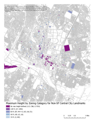
This product is for informational purposes and may not have been prepared for or be suitable for legal, engineering, and/or surveying purposes. It represents only the approximate relative location of property boundaries based on external datasets. This map has been produced for the sole purpose of geographic reference; no warranty is made by the City of Austin regarding specific accuracy or completeness. 00.510.25MileMaximum Height by Zoning Category for Non-SF Central City LandmarksNo max height defined (113; CBD, P, TOD)120 ft. (27; DMU)60 ft. (87; MF 4-5, GO, GR, CS)40 ft. (40; LO, LR)35 ft. (4; NO) This product is for informational purposes and may not have been prepared for or be suitable for legal, engineering, and/or surveying purposes. It represents only the approximate relative location of property boundaries based on external datasets. This map has been produced for the sole purpose of geographic reference; no warranty is made by the City of Austin regarding specific accuracy or completeness. 00.250.50.13MileMaximum Height by Zoning Category for Central-City Landmarks(1:20,000)Undefined (CBD, P, TOD)120 (27; DMU)60 (71; CS, GO, GR, MF 4-5)40 (35; LO, LR)35 (3; NO) This product is for informational purposes and may not have been prepared for or be suitable for legal, engineering, and/or surveying purposes. It represents only the approximate relative location of property boundaries based on external datasets. This map has been produced for the sole purpose of geographic reference; no warranty is made by the City of Austin regarding specific accuracy or completeness. 00.510.25MileMaximum FAR by Zoning Category for Central-City LandmarksUndefined (27; P, TOD, n/a)<1:1 (58; LO, LR, MF-2, MF-3, MF-4, NO)1:1 (36; GO, GR)2:1 (32; CS)5:1 (27; DMU)8:1 (91; CBD) This product is for informational purposes and may not have been prepared for or be suitable for legal, engineering, and/or surveying purposes. It represents only the approximate relative location of property boundaries based on external datasets. This map has been produced for the sole purpose of geographic reference; no warranty is made by the City of Austin regarding specific accuracy or completeness. 00.250.50.13MileMaximum FAR by Zoning Category for Central-City Landmarks(1:20,000)Undefined (18; P, TOD, n/a)<1:1 (48; LO, LR, MF-2, MF-3, MF-4, NO)1:1 (30; GO, GR)2:1 (23; CS)5:1 (27; DMU)8:1 (91; CBD) This product is for informational purposes and may not have been prepared for or be suitable for legal, engineering, and/or surveying purposes. It represents only the approximate relative location of property boundaries based on external datasets. This map has been produced for the sole purpose of geographic reference; no warranty is made by the City of Austin regarding specific accuracy or completeness. 18THCESARCHAVEZ35PEDERNALESCOMALROBERTTMARTINEZJRMARTINLUTHERKINGJR7THNASHHERNANDEZSR16THWALLERWEBBERVILLEHOLLY12THRIVERVIEWNORTHWESTERNNAVASOTAROSEWOOD2ND11TH3RDCEDAR17THCANTERBURY5TH4TH10THCHICONSANSABAMAPLEALAMOSANBERNARD14THGARDEN6TH22ND9TH21ST13TH20THNEWYORKPENNSYLVANIAWILLOW8THSANMARCOSCHALMERSANTHONYSINGLETONCOLETOCHESTNUTLEONASALINAWALNUTALEXANDERPOQUITOHASKELLNILE00.250.50.13MileBase Zoning of Existing and Recommended Landmarks/Individual NRHPProperties within 2016 East Austin Historic Resource Survey BoundariesCS (45)GR (2)LO (10)LR (3)MF-2–MF-4 (22)P (6)SF-3 (226)TOD (21) This product is for informational purposes and may not have been prepared for or be suitable for legal, engineering, and/or surveying purposes. It represents only the approximate relative location of property boundaries based on external datasets. This map has been produced for the sole purpose of geographic reference; no warranty is made by the City of Austin regarding specific accuracy or completeness. 18THCESARCHAVEZ35PEDERNALESCOMALROBERTTMARTINEZJRMARTINLUTHERKINGJR7THNASHHERNANDEZSR16THWALLERWEBBERVILLEHOLLY12THRIVERVIEWNORTHWESTERNNAVASOTAROSEWOOD2ND11TH3RDCEDAR17THCANTERBURY5TH4TH10THCHICONSANSABAMAPLEALAMOSANBERNARD14THGARDEN6TH22ND9TH21ST13TH20THNEWYORKPENNSYLVANIAWILLOW8THSANMARCOSCHALMERSANTHONYSINGLETONCOLETOCHESTNUTLEONASALINAWALNUTALEXANDERPOQUITOHASKELLNILE00.250.50.13MileBase Zoning for Existing and Recommended Landmark/NRHP Parcels within2016 East Austin Historic Resource Survey BoundariesCS (45)TOD (21)MF-2–MF-4 (22)GR (2)LO (10)LR (3)SF-3 (226)P (6) This product is for informational purposes and may not have been prepared for or be suitable for legal, engineering, and/or surveying purposes. It represents only the approximate relative location of property boundaries based on external datasets. This map has been produced for the sole purpose of geographic reference; no warranty is made by the City of Austin regarding specific accuracy or completeness. 18THCESARCHAVEZ35PEDERNALESCOMALROBERTTMARTINEZJRMARTINLUTHERKINGJR7THNASHHERNANDEZSR16THWALLERWEBBERVILLEHOLLY12THRIVERVIEWNORTHWESTERNNAVASOTAROSEWOOD2ND11TH3RDCEDAR17THCANTERBURY5TH4TH10THCHICONSANSABAMAPLEALAMOSANBERNARD14THGARDEN6TH22ND9TH21ST13TH20THNEWYORKPENNSYLVANIAWILLOW8THSANMARCOSCHALMERSANTHONYSINGLETONCOLETOCHESTNUTLEONASALINAWALNUTALEXANDERPOQUITOHASKELLNILE00.250.50.13MileMaximum Height: Existing and Recommended Landmark/NRHP Parcelswithin 2016 East Austin Historic Resource Survey BoundariesUndefined (P, TOD; 27)40 ft. (LO, LR, MF-2, MF-3; 21)60 ft. (CS, GR, MF-4; 61) This product is for informational purposes and may not have been prepared for or be suitable for legal, engineering, and/or surveying purposes. It represents only the approximate relative location of property boundaries based on external datasets. This map has been produced for the sole purpose of geographic reference; no warranty is made by the City of Austin regarding specific accuracy or completeness. 18THCESARCHAVEZ35PEDERNALESCOMALROBERTTMARTINEZJRMARTINLUTHERKINGJR7THNASHHERNANDEZSR16THWALLERWEBBERVILLEHOLLY12THRIVERVIEWNORTHWESTERNNAVASOTAROSEWOOD2ND11TH3RDCEDAR17THCANTERBURY5TH4TH10THCHICONSANSABAMAPLEALAMOSANBERNARD14THGARDEN6TH22ND9TH21ST13TH20THNEWYORKPENNSYLVANIAWILLOW8THSANMARCOSCHALMERSANTHONYSINGLETONCOLETOCHESTNUTLEONASALINAWALNUTALEXANDERPOQUITOHASKELLNILE00.250.50.13MileMaximum FAR: Existing and Recommended Landmarks/Individual NRHP Properties within2016 East Austin Historic Resource Survey BoundariesUndefined (28; P, TOD)<1:1 (34; LR, LO, MF)1:1 (2; GR)2:1 (45; CS)