A.1 - Parker House - aerial view — original pdf
Backup
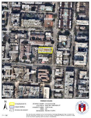
MF-6-CO-NP MF-4-NP MF-4-NP MF-4-NP MF-4-CO-NP MF-4-NP GRAHAM PL MF-4-NP MF-4-NP MF-4-CO-NP MF-4-NP MF-4-NP E V A N O T E S MF-4-CO-NP MF-4-NP GO-NP LO-NP MF-4-NP MF-4-CO-NP MF-4-CO-NP MF-4-NP MF-4-H-NP GO-H-NP C14-2019-0108 W 24TH HALF ST CS-NP MF-4-NP MF-4-NP CS-NP J24 CS-1-NP CS-NP W 25TH ST MF-5-NP W 24TH ST CS-NP W 23RD ST GO-MU-NP CS-MU-NP MF-4-NP CS-NP T S E D N A R G O R I CS-1-NP GO-NP GO-MU-H-CO-NP MF-4-NP T S S E C E U N CS-NP CS-NP MF-4-NP MF-4-NP MF-4-CO-NP Copyright nearmap 2015 PARKER HOUSE C14-2020-0015 Creek Buffers ZONING BOUNDARY ZONING CASE#: LOCATION: SUBJECT AREA: GRID: MANAGER: C14-2019-0108 2404 RIO GRANDE ST .3245 Acres J24 Heather Chaffin This map has been produced by the Communications Technology Management Dept. on behalf of the Planning Development Review Dept. for the sole purpose of geographic reference. No warranty is made by the City of Austin regarding specific accuracy or completeness. T S L R A E P GO-MU-NP CS-MU-CO-NP MF-6-CO-NP ± 1'' = 150'