A.1 - Parker House staff report — original pdf
Backup
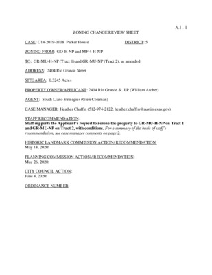
A.1 - 1 ZONING CHANGE REVIEW SHEET DISTRICT: 5 CASE: C14-2019-0108 Parker House ZONING FROM: GO-H-NP and MF-4-H-NP TO: GR-MU-H-NP (Tract 1) and GR-MU-NP (Tract 2), as amended ADDRESS: 2404 Rio Grande Street SITE AREA: 0.3245 Acres PROPERTY OWNER/APPLICANT: 2404 Rio Grande St. LP (William Archer) AGENT: South Llano Strategies (Glen Coleman) CASE MANAGER: Heather Chaffin (512-974-2122, heather.chaffin@austintexas.gov) STAFF RECOMMENDATION: Staff supports the Applicant’s request to rezone the property to GR-MU-H-NP on Tract 1 and GR-MU-NP on Tract 2, with conditions. For a summary of the basis of staff’s recommendation, see case manager comments on page 2. HISTORIC LANDMARK COMMISSION ACTION/ RECOMMENDATION: May 18, 2020: PLANNING COMMISSION ACTION / RECOMMENDATION: May 26, 2020: CITY COUNCIL ACTION: June 4, 2020: ORDINANCE NUMBER: A.1 - 2 ISSUES: The applicant proposes removing the historic landmark designation (H-) from the rear of the property only to allow redevelopment of that area (Tract 2). No change to the historic landmark designation is proposed on Tract 1, where the Parker House building is located. No changes to the Parker House structure is proposed with the rezoning request. The applicant proposes changing the base zoning on both tracts to GR-MU to allow commercial and residential uses on both tracts. The applicant originally requested CS-MU-NP zoning but later revised the request. CASE MANAGER COMMENTS: The proposed rezoning is for 0.3245 acre property located on the west side of Rio Grande Street between West 24th and West 25th Streets. The property is located in the Outer West Campus subdistrict of the West Campus/University Neighborhood Overlay (UNO). The property is also located within the West University Neighborhood Plan area. The front portion of the property is developed with the historic Parker House and is zoned GO- H-NP (Tract 1). The rear of the property is zoned MF-4-H-NP and is used for a parking area, garage, and a garage apartment. South of the property is a fraternity house and a convenience store with gas station, both zoned CS-NP. West of the property is multifamily land use, zoned MF-4-NP. North of the property is multifamily land use, zoned MF-5-NP, LO-NP, GO-NP, and MF-4-NP. Across Rio Grande Street to the east are properties zoned MF-4-NP, CS-NP, and CS- 1-NP. These properties are developed with sorority house and multifamily land uses. Please see Exhibits A and B—Zoning Map and Aerial Exhibit. The applicant is requesting that the H- designation be removed from the rear portion of the property where the parking and apartment unit is located (Tract 2). Since this area does not contain any structures of historic significance, Staff supports this request. The applicant wants to preserve the H- designation on house and front of the property (Tract 1). Staff recommends that the H-designation on Tract 1 extend back a minimum of 15 feet creating a setback between the historic tract and Tract 2. Staff supports the requested change of the base zoning districts from MF-4 and GO to GR-MU. This will allow a wider variety of land uses on the property and allow redevelopment of Tract 1. HISTORIC PRESERVATION OFFICE COMMENTS: The applicant came before the Historic Landmark Commission with a proposal to construct a new rear building on this site in the H-zoned section of the tract, even though the site for the proposed new building was a parking lot and non-historic building that did not contribute to the context of the historic Parker House. The applicant worked with the Certificate of Appropriateness Review Committee on the design of the proposed new building, and resulted in a positive recommendation for its construction. HPO staff is concerned that removal of the H zoning at this point without a commitment to construct the approved building, nor plans for another new building will result in the loss of authority to review any proposed new construction on the site. That being said, staff’s recommended buffer of 15 feet may be sufficient to protect the integrity of the context of the historic Parker House. BASIS OF RECOMMENDATION: 1. Zoning should allow for reasonable use of the property. A.1 - 3 Site North South East West The H-designation on Tract 2 effectively precludes redevelopment of Tract 2.GR-MU allows a range of land uses, including residential, office and commercial uses over the whole property. The site is currently limited to office on Tract 1 and residential on Tract 2; no mix of those uses is permitted. EXISTING ZONING AND LAND USES: ZONING LAND USES Office, Multifamily Multifamily GO-H-NP, MF-4-H-NP LO-NP, GO-NP, MF-5-NP, MF-4-NP CS- NP CS-NP, CS-1-NP, MF-4-NP Multifamily Multifamily MF-4-NP Fraternity house, Convenience store/gas station STREET CHARACTERISTICS: NEIGHBORHOOD PLANNING AREA: West University NP Area OVERLAYS: West Campus/UNO (Outer West Campus) TIA: N/A WATERSHED: Shoal Creek NEIGHBORHOOD ORGANIZATIONS: Homeless Neighborhood Association Shoal Creek Conservancy Austin Neighborhoods Council Preservation Austin Central Austin CDC Neighborhood Empowerment Foundation OTHER STAFF COMMENTS: ENVIRONMENTAL 1. The site is not located over the Edwards Aquifer Recharge Zone. The site is located in the Shoal Creek Watershed of the Colorado River Basin, which is classified as an Urban Watershed by Chapter 25-8 of the City's Land Development Code. 2. Zoning district impervious cover limits apply in the Urban Watershed classification. 3. According to floodplain maps there is no floodplain within or adjacent to the property. AISD My Guadalupe CANPAC Friends of Austin Neighborhoods Sierra Club Bike Austin A.1 - 4 4. Standard landscaping and tree protection will be required in accordance with LDC 25-2 and 25-8 for all development and/or redevelopment. 5. At this time, site specific information is unavailable regarding vegetation, areas of steep slope, or other environmental features such as bluffs, springs, canyon rimrock, caves, sinkholes, and wetlands. 6. This site is required to provide on-site water quality controls (or payment in lieu of) for all development and/or redevelopment when 8,000 s.f. cumulative is exceeded, and on site control for the two-year storm. SITE PLAN SP 1. Site plans will be required for any new development other than single-family or duplex residential. SP 2. Any development which occurs in an SF-6 or less restrictive zoning district which is located 540 feet or less from property in an SF-5 or more restrictive zoning district will be subject to compatibility development regulations. SP 3. Any new development is subject to Subchapter E. Design Standards and Mixed Use. Additional comments will be made when the site plan is submitted. SP 4. FYI: Additional design regulations will be enforced at the time a site plan is submitted. COMPATIBILITY STANDARDS SP 5. The entire site is subject to compatibility standards due to proximity to property zoned SF- 3-NP on all sides. The following standards apply: · For a structure more than 100 feet but not more than 300 feet from property zoned SF-5 or more restrictive, height limitation is 40 feet plus one foot for each 10 feet of distance in excess of 100 feet from the property zoned SF-5 or more restrictive. · For a structure more than 300 feet but not more than 540 feet from property zoned SF-5 or more restrictive, 60 feet plus one foot for each four feet of distance in excess of 300 feet from the property zoned SF-5 or more restrictive. SP 7. The site is subject to 25-2 Subchapter F. Residential Design and Compatibility Standards. TRANSPORTATION A traffic impact analysis shall be required at the time of site plan if triggered. The Austin Strategic Mobility Plan (ASMP) adopted 04/11/2019, calls for 60 feet of right-of-way for Rio Grande St. Additional right-of-way maybe required at the time of subdivision and/or site plan. The adjacent street characteristics table is provided below: WATER UTILITY 1. The landowner intends to serve the site with City of Austin water and wastewater utilities. The landowner, at own expense, will be responsible for providing any water and wastewater utility improvements, offsite main extensions, utility relocations and or abandonments required by the land use. Water and wastewater utility plans must be reviewed and approved by the A.1 - 5 Austin Water Utility for compliance with City criteria. All water and wastewater construction must be inspected by the City of Austin. The landowner must pay the City inspection fee with the utility construction. The landowner must pay the tap and impact fee once the landowner makes an application for a City of Austin water and wastewater utility tap permit. INDEX OF EXHIBITS TO FOLLOW A: Zoning Map B. Aerial Exhibit