REGULAR MEETING OF THE ZONING AND PLATTING COMMISSION TUESDAY, JULY 7, 2026, AT 6 P.M. AUSTIN CITY HALL, COUNCIL CHAMBERS, ROOM 1001 301 WEST 2ND STREET AUSTIN, TEXAS Some members of the Zoning and Platting Commission may be participating by videoconference. The meeting may be viewed online at: http://www.austintexas.gov/page/watch-atxn-live Public comment will be allowed in-person or remotely via telephone. Speakers may only register to speak on an item once either in-person or remotely and will be allowed up to three minutes to provide their comments. Registration no later than 2 p.m. on the day of the meeting is required for remote participation by telephone. To register to speak remotely, please use the QR code or link at the end of this document. If you have questions regarding speaker registration, please contact Ella Garcia, Staff Liaison, at LandUseLiaison@austintexas.gov or by phone at 512-978-0821. CURRENT COMMISSIONERS: Hank Smith, Chair (District 8) Betsy Greenberg, Vice Chair (District 10) Ryan Puzycki, Secretary (District 7) Alejandra Flores, Parliamentarian (District 5) Luis Osta Lugo (Mayor’s Representative) Scott Boone (District 1) David Fouts (District 2) Lonny Stern (District 3) Andrew Cortes (District 4) Christian Tschoepe (District 6) Taylor Major (District 9) Staff Liaison: Ella Garcia, 512-978-0821 Attorney: AJ Urteaga, 512-974-2386 Page 1 of 6 AGENDA CALL TO ORDER PUBLIC COMMUNICATION: GENERAL The first four speakers signed up prior to the meeting being called to order will each be allowed a three-minute allotment to address their concerns regarding items not posted on the agenda. APPROVAL OF MINUTES 1. Approve the minutes of the Zoning and Platting Commission regular meeting on Tuesday, June 16, 2026. PUBLIC HEARINGS 2. Rezoning: Location: C14-2026-0027 - 4106 Medical Parkway; District 10 4106, a portion of 4100, 4102 ½, and 4104 Medical Parkway, Shoal Creek Watershed Owner/Applicant: Medical Parkway Plaza, LLC Agent: Request: Staff Rec.: Staff: HD Brown Consulting (Amanda Brown) LO to GR-CO-ETOD-DBETOD Recommended Cynthia Hadri, 512-974-7620, cynthia.hadri@austintexas.gov Austin Planning 3. Rezoning: Location: C14-2026-0033 - Capital of Texas Reservoir GST Rezoning; District 8 1107 ½ North Capital of Texas Highway North Bound, Bee Creek Watershed Owner/Applicant: City of Austin Water Department (Eric Sermeno) Request: Staff Rec.: Staff: I-RR and SF-2 to P Recommended Cynthia Hadri, 512-974-7620, cynthia.hadri@austintexas.gov Austin Planning 4. Rezoning: Location: C14-2025-0089 - 1120 and 1122 S Capital of Texas Highway; District 8 1120 ½ South Capital of Texas Hwy SB, 1120 South Capital of Texas Hwy SB, 1122 South Capital of …
SPEAKER REGISTRATION All participants wishing to address the commission must register to speak. Public participation is available by teleconference or in-person. Presentations and handouts are requested to be e- mailed by 1:00 p.m. on the day of the meeting. TELECONFERNCE REGISTRATION Registration for participation by teleconference closes at 2:00 p.m., the day of the meeting. Teleconference code and additional information to be provided after the closing of the teleconference registration period. IN-PERSON REGISTRATION While in-person registrants are encouraged to register in advance of the meeting, in-person registration closes at 5:30 p.m., the day of the meeting. Please scan the QR code below with a mobile device or click on the link below. Mobile devices will also be available at the meeting for public use for the purpose of speaker registration. SPEAKER DONATION OF TIME For discussion cases, speaker donation of time is an available option for in-person participants. Both the registered speaker donating time and the speaker recipient must be present when the public hearing is conducted. See chart below regarding speaker time allotments. SPEAKING ORDER The speaking order is determined by the order in which individuals register to speak and is conducted on a first-come, first-served basis. If multiple speakers register as the Primary Speaker, the first to register is allotted the additional speaking time. Participants who are part of a group or organization and wish to request a specific speaking order must contact Ella Garcia, Staff Liaison, at LandUseLiaison@austintexas.gov or 512-978-0821 as soon as possible, and no later than 2:00 p.m. on the day of the meeting. Click on the link below or scan the QR code and submit the form to register to speak. Speakers should submit a separate registration form for each item of interest. https://forms.office.com/g/Ash1EsNFf4 SPEAKER TESTIMONY TIME ALLOCATION PUBLIC HEARING Speaker Number Time Allocated Total Time Allocated Applicant/Agent or primary speaker in favor Primary speaker in opposition 1 1 6 minutes 12 minutes (with donated time, including 3-minute rebuttal) 6 minutes 9 minutes (with donated time) All other speakers in favor or opposition Unlimited 3 minutes 6 minutes (with donated time) All speakers are allowed three (3) minutes of donated time from a speaker present during the Public Hearing.
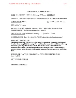
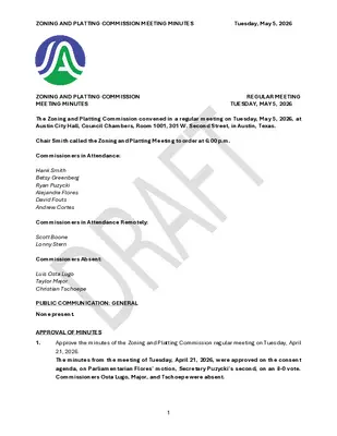
ZONING AND PLATTING COMMISSION MEETING MINUTES Tuesday, June 16, 2026 ZONING AND PLATTING COMMISSION REGULAR MEETING TUESDAY, JUNE 16, 2026 MEETING MINUTES The Zoning and Platting Commission convened in a regular meeting on Tuesday, June 16, 2026, at Austin City Hall, Council Chambers, Room 1001, 301 W. Second Street, in Austin, Texas. Chair Smith called the Zoning and Platting Meeting to order at 6 p.m. Commissioners in Attendance: Hank Smith Betsy Greenberg Andrew Cortes Luis Osta Lugo Lonny Stern Commissioners in Attendance Remotely: Alejandra Flores Ryan Puzycki Scott Boone David Fouts Taylor Major Christian Tschoepe PUBLIC COMMUNICATION: GENERAL None present. APPROVAL OF MINUTES 1. Approve the minutes of the Zoning and Platting Commission regular meeting on Tuesday, June 2, 2026. The minutes from the meeting of Tuesday, June 2, 2026, were approved on the consent agenda, on Commissioner Stern’s motion, Commissioner Osta Lugo’s second, on an 11-0 vote. 1 ZONING AND PLATTING COMMISSION MEETING MINUTES Tuesday, June 16, 2026 PUBLIC HEARINGS 2. Zoning: Location: C14-2026-0009 - 11819 IH-35 Zoning - 7.71 acres; District 5 11809, 11809 ½, & 11819 South Interstate Highway-35 Service Road Northbound, Onion Creek Watershed Owner/Applicant: Protestant Episcopal Church Council of the Diocese of Texas (Michael Agent: Request: Staff Rec.: Staff: Hilfinger) H.D. Brown Consulting, LLC (Amanda Brown) I-SF-2 to GR-MU-CO Recommended Sherri Sirwaitis, 512-974-3057, sherri.sirwaitis@austintexas.gov Austin Planning The motion to approve Staff’s recommendation of GR-MU-CO for C14-2026-0009 - 11819 IH-35 Zoning - 7.71 acres; District 5, located at 11809, 11809 ½, & 11819 South Interstate Highway-35 Service Road Northbound, was approved on the consent agenda on Commissioner Stern’s motion, Commissioner Osta Lugo’s second, on an 11-0 vote. 3. Zoning: Location: C14-2026-0025 - 11819 IH-35 Zoning - 1.9 acres; District 5 11819 & 11819 ½ South Interstate Highway-35 Service Road Northbound, Onion Creek Watershed Owner/Applicant: Protestant Episcopal Church Council of the Diocese of Texas (Michael Agent: Request: Staff Rec.: Staff: Hilfinger) H.D. Brown Consulting, LLC (Amanda Brown) Unzoned to GR-MU-CO Recommended Sherri Sirwaitis, 512-974-3057, sherri.sirwaitis@austintexas.gov Austin Planning The motion to approve Staff’s recommendation of GR-MU-CO for C14-2026-0025 - 11819 IH-35 Zoning - 1.9 acres; District 5, located at 11819 & 11819 ½ South Interstate Highway- 35 Service Road Northbound, was approved on the consent agenda on Commissioner Stern’s motion, Commissioner Osta Lugo’s second, on an 11-0 vote. 4. Rezoning: Location: C14-2024-0092 - Allred, Riddle, and W. Slaughter; District 5 2205, 2207, 2209, & 2200 Riddle Road; 2200, …
ZONING CHANGE REVIEW SHEET CASE: C14-2026-0027 – 4106 Medical Parkway DISTRICT: 10 ZONING FROM: LO ZONING TO: GR-CO-ETOD-DBETOD ADDRESS: 4106, a portion of 4100, 4102 1/2, and 4104 Medical Parkway SITE AREA: 1.0 acres (43, 560 sq. ft.) PROPERTY OWNER: Medical Parkway Plaza, LLC AGENT: HD Brown Consulting (Amanda Brown) CASE MANAGER: Cynthia Hadri 512-974-7620, Cynthia.hadri@austintexas.gov STAFF RECOMMENDATION: The staff recommendation is to grant community commercial – conditional overlay - equitable transit-oriented development – density bonus equitable transit-oriented development (GR-CO-ETOD-DBETOD) combined district zoning. The conditional overlay is for a maximum height of 50 feet on the property. The applicant is not seeking a modification request for the ground floor pedestrian- oriented commercial space. ZONING AND PLATTING COMMISSION ACTION / RECOMMENDATION: July 7, 2026: CITY COUNCIL ACTION: ORDINANCE NUMBER: ISSUES: On March 9, 2023, City Council approved Resolution No. 20230309-016 accepting the Equitable Transit-Oriented Development Policy Plan and directing the City Manager regarding next steps for implementation of items intended to benefit the Project Connect Phase 1 Austin Light Rail project. This included development of code amendments to support transit in May of 2024 (Ordinance No. 20240516-005), including creation of the ETOD combining district (restrictions on non-transit supportive uses) and the DBETOD combining district (allowing residential use, and relaxing some development standards 02 C14-2026-0027 - 4106 Medical Parkway; District 101 of 14 C14-2026-0027 2 including increased height in exchange for income-restricted housing). Properties within one half-mile of the Phase 1 Austin Light Rail alignment and Priority Extensions were included within this overlay, and certain properties were rezoned through a City-initiated process to include the ETOD and DBETOD combining districts. Further, properties rezoned with DBETOD combining district were categorized into Subdistrict 1 (maximum allowable height of 120 feet) or Subdistrict 2 (maximum allowable height of 90 feet), generally based on property distance of ¼-mile or ½-mile from the Phase 1 alignment, respectively. However, some properties within the one half-mile buffer were not included in this City-initiated process, which is the subject of this request. CASE MANAGER COMMENTS: The property in question is approximately one acre, developed with one commercial building at approximately 6,500 square feet and a parking lot. The property is on Medical Parkway a level 3 Austin Strategic Mobility Plan (ASMP), an Imagine Austin Corridor and is adjacent to the Burnet Road Activity Corridor. The site is currently zoned Limited Office (LO) district zoning and is surrounded by office, commercial …
ZONING CHANGE REVIEW SHEET CASE: C14-2026-0033 - Capital of Texas Reservoir GST Rezoning DISTRICT: 8 ZONING FROM: I-RR and SF-2 ZONING TO: P ADDRESS: 1107 1/2 N Capital of Texas Hwy NB SITE AREA: 2.72 acres (118, 483 sq. ft.) PROPERTY OWNER/AGENT: Austin Water (Eric Sermeno) CASE MANAGER: Cynthia Hadri 512-974-7620, Cynthia.hadri@austintexas.gov STAFF RECOMMENDATION: The staff recommendation is to grant public (P) district zoning. ZONING AND PLATTING COMMISSION ACTION / RECOMMENDATION: July 7, 2026: CITY COUNCIL ACTION: ORDINANCE NUMBER: ISSUES: It is Current Planning’s understanding that the telecommunications tower owner will seek a conditional use permit (CUP) application following this rezoning. The conditional use permit (CUP) process will also require a public hearing when filed. CASE MANAGER COMMENTS: The property in question is approximately 2.72 acres, partially developed with the Reservoir Tower, AT& T Cell tower and shelter house. The property has access to N Capital of Texas HWY NB an ASMP Level 5 and is currently interim – rural residence (I-RR) and single- family residence standard lot (SF-2). The surround properties that are developed have single family residential (PUD; SF-2; SF-1). The Vireo Preserve and Wild Basin Wilderness Preserve are both adjacent to this property. Please refer to Exhibits A (Zoning Map) and B (Aerial View). Staff recommends the requested Public (P) district zoning as it is consistent with the purpose statement, which is intended for land owned or leased by a governmental entity. The City of 03 C14-2026-0033 - Capital of Texas Reservoir GST Rezoning; District 81 of 12 C14-2026-0033 2 Austin (COA) took over of the Davenport Ranch MUD No. 1 (MUD) on 12/31/1997 via Ordinance No. 971120-I and in so doing inherited all assets ad labilities. Currently, COA Autin Water (AW) is out of compliance with City Council’s general policy that all City owned, or leased, land be zoned public (P) district. This is the main reason for AW requesting the city’s approval to rezone the property to the appropriate zoning for current usage, which is Public “P” district. It should be noted; this location does have an existing, approximate 35-feet tall AT&T tower with an equipment shelter and lease agreement executed prior to COA annexing the Davenport Ranch MUD No. 1 in Dec.1997. Originally, the tower lease was with Davenport Ranch MUD No.1. BASIS OF RECOMMENDATION: 1. The proposed zoning should be consistent with the purpose statement of the district sought. The public district land …
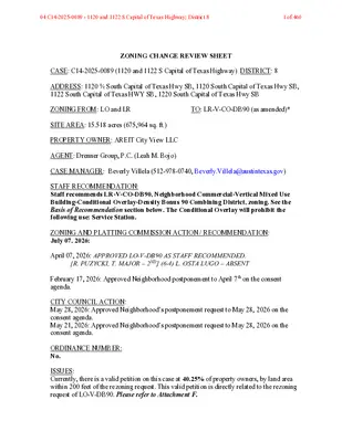
ZONING CHANGE REVIEW SHEET CASE: C14-2025-0089 (1120 and 1122 S Capital of Texas Highway) DISTRICT: 8 ADDRESS: 1120 ½ South Capital of Texas Hwy SB, 1120 South Capital of Texas Hwy SB, 1122 South Capital of Texas HWY SB, 1220 South Capital of Texas Hwy SB ZONING FROM: LO and LR TO: LR-V-CO-DB90 (as amended)* SITE AREA: 15.518 acres (675,964 sq. ft.) PROPERTY OWNER: AREIT City View LLC AGENT: Drenner Group, P.C. (Leah M. Bojo) CASE MANAGER: Beverly Villela (512-978-0740, Beverly.Villela@austintexas.gov) STAFF RECOMMENDATION: Staff recommends LR-V-CO-DB90, Neighborhood Commercial-Vertical Mixed Use Building-Conditional Overlay-Density Bonus 90 Combining District, zoning. See the Basis of Recommendation section below. The Conditional Overlay will prohibit the following use: Service Station. ZONING AND PLATTING COMMISSION ACTION / RECOMMENDATION: July 07, 2026: April 07, 2026: APPROVED LO-V-DB90 AS STAFF RECOMMENDED. [R. PUZYCKI, T. MAJOR – 2ND] (6-4) L. OSTA LUGO – ABSENT February 17, 2026: Approved Neighborhood postponement to April 7th on the consent agenda. CITY COUNCIL ACTION: May 28, 2026: Approved Neighborhood’s postponement request to May 28, 2026 on the consent agenda. May 21, 2026: Approved Neighborhood’s postponement request to May 28, 2026 on the consent agenda. ORDINANCE NUMBER: No. ISSUES: Currently, there is a valid petition on this case at 40.25% of property owners, by land area within 200 feet of the rezoning request. This valid petition is directly related to the rezoning request of LO-V-DB90. Please refer to Attachment F. 04 C14-2025-0089 - 1120 and 1122 S Capital of Texas Highway; District 81 of 460 C14-2025-0089 Page 2 *On June 22, 2026, the applicant submitted an amended rezoning request for LR-V-DB90. Staff recommended the addition of a Conditional Overlay that would prohibit the use, Service Station. The applicant is in agreement with staff’s recommendation. CASE MANAGER COMMENTS: The subject property consists of approximately 15.5 acres located at 1120 ½, 1120, 1122, and 1220 South Capital of Texas Highway southbound, on the west side of South Capital of Texas Highway (Loop 360), south of Lost Creek Boulevard, and within the City of Austin’s Full Purpose Jurisdiction. South Capital of Texas Highway is a Level 5 corridor per the Austin Strategic Mobility Plan (ASMP) and Lost Creek Boulevard is a Level 3. The site is currently developed with office uses and a parking garage and is zoned Limited Office (LO) and Neighborhood Commercial (LR). Surrounding land uses include offices and townhomes to the north (LR; MF-1-CO; LO; …
04 C14-2025-0089 - 1120 and 1122 S Capital of Texas Highway; District 888 of 460 04 C14-2025-0089 - 1120 and 1122 S Capital of Texas Highway; District 889 of 460 04 C14-2025-0089 - 1120 and 1122 S Capital of Texas Highway; District 890 of 460 04 C14-2025-0089 - 1120 and 1122 S Capital of Texas Highway; District 891 of 460 04 C14-2025-0089 - 1120 and 1122 S Capital of Texas Highway; District 892 of 460 04 C14-2025-0089 - 1120 and 1122 S Capital of Texas Highway; District 893 of 460 04 C14-2025-0089 - 1120 and 1122 S Capital of Texas Highway; District 894 of 460 04 C14-2025-0089 - 1120 and 1122 S Capital of Texas Highway; District 895 of 460 04 C14-2025-0089 - 1120 and 1122 S Capital of Texas Highway; District 896 of 460 04 C14-2025-0089 - 1120 and 1122 S Capital of Texas Highway; District 897 of 460 04 C14-2025-0089 - 1120 and 1122 S Capital of Texas Highway; District 898 of 460 04 C14-2025-0089 - 1120 and 1122 S Capital of Texas Highway; District 899 of 460 04 C14-2025-0089 - 1120 and 1122 S Capital of Texas Highway; District 8100 of 460 04 C14-2025-0089 - 1120 and 1122 S Capital of Texas Highway; District 8101 of 460 04 C14-2025-0089 - 1120 and 1122 S Capital of Texas Highway; District 8102 of 460 04 C14-2025-0089 - 1120 and 1122 S Capital of Texas Highway; District 8103 of 460 04 C14-2025-0089 - 1120 and 1122 S Capital of Texas Highway; District 8104 of 460 04 C14-2025-0089 - 1120 and 1122 S Capital of Texas Highway; District 8105 of 460 04 C14-2025-0089 - 1120 and 1122 S Capital of Texas Highway; District 8106 of 460 04 C14-2025-0089 - 1120 and 1122 S Capital of Texas Highway; District 8107 of 460 04 C14-2025-0089 - 1120 and 1122 S Capital of Texas Highway; District 8108 of 460 04 C14-2025-0089 - 1120 and 1122 S Capital of Texas Highway; District 8109 of 460 04 C14-2025-0089 - 1120 and 1122 S Capital of Texas Highway; District 8110 of 460 C14-2025-0089 Page 17 Attachment G 04 C14-2025-0089 - 1120 and 1122 S Capital of Texas Highway; District 8111 of 460 04 C14-2025-0089 - 1120 and 1122 S Capital of Texas Highway; District 8112 of 460 Villela, Beverly From: Sent: To: Subject: Patti Brennan Tuesday, March 31, 2026 10:17 PM Villela, Beverly; ; ; Case C14-2025-0089 …
04 C14-2025-0089 - 1120 and 1122 S Capital of Texas Highway; District 8452 of 460 Villela, Beverly From: Sent: To: Subject: Attachments: Monday, May 4, 2026 6:16 PM Villela, Beverly Case Number: C14-2025-0089 - objection to project. 2026 LC PH Objection.pdf Categories: C14-2025-0089 - 1120 and 1122 S Capital Tx You don't often get email from . Learn why this is important External Email - Exercise Caution Attached please find my objection to the zoning change for the Lost Creek Project. Case Number: C14-2025- 0089 TREC Consumer Protection Notice TREC Information About Brokerage Services Sheila T. Hilts, Broker Sheila T. Hilts Real Estate Co., Inc. GRI, ABR, CRS, Broker and 5 Star Professional 1207 Wilson Heights DR. Austin, TX 78746 512-413-3953 – mobile CAUTION: This is an EXTERNAL email. Please use caution when clicking links or opening attachments. If you believe this to be a malicious or phishing email, please report it using the "Report Message" button in Outlook. For any additional questions or concerns, contact CSIRT at . 10 04 C14-2025-0089 - 1120 and 1122 S Capital of Texas Highway; District 8453 of 460 04 C14-2025-0089 - 1120 and 1122 S Capital of Texas Highway; District 8454 of 460 Villela, Beverly From: Sent: To: Subject: Mike Bruno Monday, May 4, 2026 2:22 PM Villela, Beverly Zoning Case C14-2025-0089 Categories: C14-2025-0089 - 1120 and 1122 S Capital Tx You don't often get email from . Learn why this is important External Email - Exercise Caution Dear Ms. Villela, I am writing regarding Zoning Case C14-2025-0089 and the proposed development at Loop 360 and Lost Creek Blvd. Lost Creek Blvd is already facing significant planned growth, including two major housing developments that will materially increase traffic volume and congestion in the near term. Adding this proposed project on top of that existing pipeline of development risks overloading the corridor beyond what it can safely handle. Of particular concern is emergency access and evacuation capacity. Lost Creek has limited ingress and egress, and additional density without a clear, validated plan for traffic flow and evacuation could create serious safety risks for residents, especially in a wildfire or other emergency scenario. Given these factors, I strongly support postponing the vote until comprehensive traffic and wildfire evacuation studies are completed and incorporated into the decision-making process. It is critical that cumulative impacts from all planned developments are evaluated together, not in isolation. Thank you …
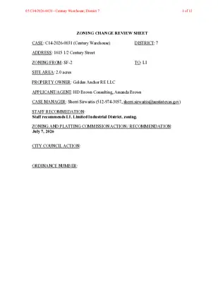
ZONING CHANGE REVIEW SHEET CASE: C14-2026-0031 (Century Warehouse) DISTRICT: 7 ADDRESS: 1615 1/2 Century Street ZONING FROM: SF-2 SITE AREA: 2.0 acres TO: LI PROPERTY OWNER: Golden Anchor RE LLC APPLICANT/AGENT: HD Brown Consulting, Amanda Brown CASE MANAGER: Sherri Sirwaitis (512-974-3057, sherri.sirwaitis@austintexas.gov) STAFF RECOMMEDATION: Staff recommends LI, Limited Industrial District, zoning. ZONING AND PLATTING COMMISSION ACTION / RECOMMENDATION: July 7, 2026 CITY COUNCIL ACTION: ORDINANCE NUMBER: 05 C14-2026-0031 - Century Warehouse; District 71 of 12 C14-2026-0031 ISSUES: N/A CASE MANAGER COMMENTS: 2 The property in question is currently developed with a general warehousing and distribution use. To the north, across Century Street, there are construction sales and services (Timber Town Austin), warehouse and distribution, food truck court and restaurant (Amazonas) uses. The property to the south is developed with a retail center that contains restaurant (Texas Roadhouse, Austin’s Pizza, Kung Fu Buffet), general retail sales, personal services (Generations Barber Shop, CBD, Glam Beauty Bar, Fast Signs, Signature Smiles, Ashley Furniture, Enso Nails, Wild Magnolias) and indoor entertainment (Cinemark Movie Theater) uses. To the west of the site, there are automotive repair businesses (G&G Auto Body, Austin Car Protection and Window Tint) and a construction sales and services use (Pflugerville Propane Rental). In this case, the applicant is requesting LI, Limited Industrial District, zoning to bring the existing use into conformance with the City of Austin zoning regulations. The staff supports the requested LI district zoning because the property is located adjacent to existing commercial and industrial uses to the north, east and west. There is LI and LI-CO zoning to the north and east, CS-CO zoning to the west and GR-CO zoning to the south of the site under consideration. The proposed rezoning of the site will allow the applicant to continue the existing use or to develop new commercial and industrial uses at this location. The applicant agrees with the staff recommendation. BASIS OF RECOMMENDATION: 1. The proposed zoning should be consistent with the purpose statement of the district sought. Limited Industrial Service district is intended as an area primarily for commercial services and limited manufacturing uses, generally on moderately sized sites. 2. The proposed zoning should promote consistency and orderly planning. The property in question is located adjacent to existing commercial and industrial uses to the north, east and west. There is LI and LI-CO zoning to the north and east, CS-CO zoning to the west and GR-CO …
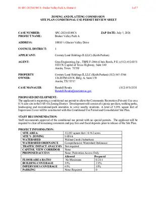
ZONING AND PLATTING COMMISSION SITE PLAN CONDITIONAL USE PERMIT REVIEW SHEET CASE NUMBER: PROJECT NAME: SPC-2025-0350CS Braker Valley Park A ZAP DATE: July 7, 2026 ADDRESS: 10910 ½ Glacier Valley Drive COUNCIL DISTRICT: 1 APPLICANT: Century Land Holdings II (LLC) (Keith Parkan) AGENT: PROPERTY OWNER: Gray Engineering, Inc., TBPE F-2946 (Chris Rawls, P.E.) (512) 452-0371 8834 N. Capital of Texas Highway, Suite 140 Austin, Texas 78759 Century Land Holdings II, LLC (Keith Parkan) (512) 567-8766 13620 FM 620 N. Bldg. A, Suite 170 Austin, TX 78717 CASE MANAGER: Randall Rouda Randall.Rouda@austintexas.gov (512) 978-3338 PROPOSED DEVELOPMENT: The applicant is requesting a conditional use permit to allow the Community Recreation (Private) Use on a 0.76 acre site in the I-SF-4A Zoning District. Development will consist of a picnic pavilion, walking paths, landscaping and recreational/park amenities to serve nearby residents. A total of 5,976 square feet of Impervious Cover will be constructed with this Conditional Use Permit and Consolidated Site Plan. STAFF RECOMMENDATION: Staff recommends approval of the conditional use permit with no special permits. The applicant will be required to clear all remaining comments and pay fees and fiscal deposits prior to release of the Site Plan. PROJECT INFORMATION: SITE AREA: SITE’S ZONING WATERSHED WATERSHED ORDINANCE TRAFFIC IMPACT ANALYSIS Not required CAPITOL VIEW CORRIDOR PROPOSED ACCESS 33,193 square feet / 0.762 acres I-SF4A Walnut Creek (Suburban) Comprehensive Watershed Ordinance None None: Pedestrian Access Only Allowed No Maximum 55% 65% None Required Proposed 0.28:1 2.8% 18% 0 FLOOR-AREA RATIO BUILDING COVERAGE IMPERVIOUS COVERAGE PARKING 06 SPC-2025-0350CS - Braker Valley Park A; District 11 of 7 Braker Valley Park A SPC-2025-0350CS 2 SUMMARY COMMENTS ON SITE PLAN: Land Use: The property is currently vacant and consists of one lot in the SF-4A Zoning District. The site is proposed to serve as a local park (Community Recreation – Private) for nearby residents. The site will be developed with a picnic pavilion, walking paths, recreational and landscape amenities. The development has been fully reviewed as a Consolidated Site Plan and all substantive comments have been cleared. Environmental: The site is located in the Walnut Creek Watershed. As designed, the site complies with all applicable drainage, water quality and environmental protection standards. Transportation: There is no vehicular access or parking on the site. Street parking and vehicular access are available on the adjacent streets, Mystic Timber Drive and Glacier Valley Drive. Sidewalks along the street frontage will …
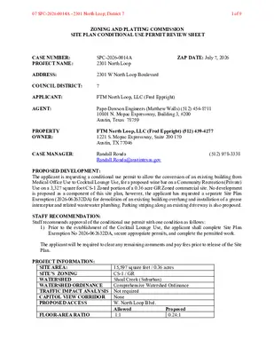
ZONING AND PLATTING COMMISSION SITE PLAN CONDITIONAL USE PERMIT REVIEW SHEET CASE NUMBER: PROJECT NAME: SPC-2026-0014A 2301 North Loop ZAP DATE: July 7, 2026 ADDRESS: 2301 W North Loop Boulevard COUNCIL DISTRICT: 7 APPLICANT: FTM North Loop, LLC (Fred Eppright) AGENT: PROPERTY OWNER: Pape-Dawson Engineers (Matthew Walls) (512) 454-8711 10801 N. Mopac Expressway, Building 3, #200 Austin, Texas 78759 FTM North Loop, LLC (Fred Eppright) (512) 439-4277 1221 S. Mopac Expressway, Suite 200 170 Austin, TX 77046 CASE MANAGER: Randall Rouda Randall.Rouda@austintexas.gov (512) 978-3338 PROPOSED DEVELOPMENT: The applicant is requesting a conditional use permit to allow the conversion of an existing building from Medical Office Use to Cocktail Lounge Use, for a proposed wine bar on a Community Recreation (Private) Use on a 3,327 square foot CS-1 Zoned portion of a 0.36 acre GR Zoned commercial site. No development is proposed as a component of this site plan, however, the applicant has requested a separate Site Plan Exemption (2026-062632DA) for demolition of an existing building overhang and installation of a grease interceptor and related wastewater plumbing. Parking striping along an existing driveway is also proposed. STAFF RECOMMENDATION: Staff recommends approval of the conditional use permit with one condition as follows: 1) Prior to the establishment of the Cocktail Lounge Use, the applicant shall complete Site Plan Exemption No 2026-062632DA, secure appropriate permits, and complete the permitted work. The applicant will be required to clear any remaining comments and pay fees prior to release of the Site Plan. PROJECT INFORMATION: SITE AREA: SITE’S ZONING WATERSHED WATERSHED ORDINANCE TRAFFIC IMPACT ANALYSIS Not required CAPITOL VIEW CORRIDOR PROPOSED ACCESS 15,597 square feet / 0.36 acres CS-1 / GR Shoal Creek (Suburban) Comprehensive Watershed Ordinance None W. North Loop Blvd. Allowed 1:1 Proposed 0.24:1 FLOOR-AREA RATIO 07 SPC-2026-0014A - 2301 North Loop; District 71 of 9 2301 North Loop SPC-2026-0014A 2 BUILDING COVERAGE IMPERVIOUS COVERAGE PARKING 75% 90% None Required 23% 89.6% 22 SUMMARY COMMENTS ON SITE PLAN: Land Use: The property is developed with a Medical Office Use. On February 26, 2026, Ordinance No. 20260266-076 was adopted to change the zoning for the 3,627 square feet of the property that is within the existing building from GR to CS-1. The CS-1 Zone allows the Cocktail Lounge Use with a Conditional Use Permit. No changes to the building footprint are proposed. Cocktail Lounges are generally not permitted within 300 feet of a church, public …
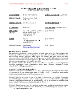
ZONING & PLATTING COMMISSION SITE PLAN EXTENSION REVIEW SHEET CASE NUMBER: SP-2019-0215C.SH (XT2) ZAP HEARING DATE:July 07, 2026 PROJECT NAME: The Grove at Shoal Creek Blocks 1 & 2 ADDRESS OF SITE: 4512 Denali Summit Dr COUNCIL DISTRICT: 10 WATERSHED: Shoal Creek JURISDICTION: Austin Full Purpose APPLICANT/ OWNER: AGENT: Grove ATX 1, LP & Grove ATX 2, LP (512) 686-4986 3600 N Capital of Texas Hwy Building B, Suite 320 Austin, Tx 78746 BGE, Inc 1701 Directors Blvd Suite 1000 Austin, TX 78744 (512) 879-0400 CASE MANAGER: Chris Sapuppo (512) 978-4556 chris.sapuppo@austintexas.gov PROPOSED DEVELOPMENT: The applicant is proposing a (3) year extension to a previously approved site plan. The construction of a multi-family rental and commercial development that includes 508 residential units on a 7.71-acre site with associated parking, driveways, storm sewers, rain gardens, and water quality and utility improvements for a total of 246,985 square feet of impervious cover (73.5%). In addition to the existing impervious cover from previous Grove applications (33.71 acres), the cumulative impervious cover across the entire Grove development (75.76 acres) is now 57.3%. The project is located within the Shoal Creek watershed and is subject to all watershed protection regulations as set forth in Chapter 25 of the City of Austin Code of Ordinances. This project is located within the City’s Full-Purpose jurisdiction. SUMMARY STAFF RECOMMENDATION: Staff recommends approval to extend this site plan permit by three (3) years, from April 24, 2026 to April 24, 2029 based on the case meeting criteria from LDC Section 25-5-62(C). The applicant has included a justification letter explaining details of this site (see attached). 25-5-63(C) Extension of released site plan by the Land Use Commission: “the Land Use Commission may extend the expiration date of a released site plan beyond the date established by this chapter if the Land Use Commission determines that the request complies with the requirements for extension by the director under 25-5-62 (Extension of Released Site Plan by Director).” 25-5-62(C) The director may extend the expiration date of a released administrative site plan one time for a period of one year if the director determines that there is good cause for the requested extension; and “ (1) the director determines that: 08 SP-2019-0215C.SH(XT2) - The Grove Blocks 1 & 2; District 101 of 7 SP-2019-0215C.SH (XT2) The Grove at Shoal Creek Blocks 1 & 2 (a) the site plan substantially complies with the requirements …
REGULAR MEETING OF THE ZONING AND PLATTING COMMISSION TUESDAY, JUNE 16, 2026, AT 6 P.M. AUSTIN CITY HALL, COUNCIL CHAMBERS, ROOM 1001 301 WEST 2ND STREET AUSTIN, TEXAS Some members of the Zoning and Platting Commission may be participating by videoconference. The meeting may be viewed online at: http://www.austintexas.gov/page/watch-atxn-live Public comment will be allowed in-person or remotely via telephone. Speakers may only register to speak on an item once either in-person or remotely and will be allowed up to three minutes to provide their comments. Registration no later than 2 p.m. on the day of the meeting is required for remote participation by telephone. To register to speak remotely, please use the QR code or link at the end of this document. If you have questions regarding speaker registration, please contact Ella Garcia, Staff Liaison, at LandUseLiaison@austintexas.gov or by phone at 512-978-0821. CURRENT COMMISSIONERS: Hank Smith, Chair (District 8) Betsy Greenberg, Vice Chair (District 10) Ryan Puzycki, Secretary (District 7) Alejandra Flores, Parliamentarian (District 5) Luis Osta Lugo (Mayor’s Representative) Scott Boone (District 1) David Fouts (District 2) Lonny Stern (District 3) Andrew Cortes (District 4) Christian Tschoepe (District 6) Taylor Major (District 9) Staff Liaison: Ella Garcia, 512-978-0821 Attorney: Steve Maddoux, 512-974-6080 Page 1 of 6 AGENDA CALL TO ORDER PUBLIC COMMUNICATION: GENERAL The first four speakers signed up prior to the meeting being called to order will each be allowed a three-minute allotment to address their concerns regarding items not posted on the agenda. APPROVAL OF MINUTES 1. Approve the minutes of the Zoning and Platting Commission regular meeting on Tuesday, June 2, 2026. PUBLIC HEARINGS 2. Zoning: Location: C14-2026-0009 - 11819 IH-35 Zoning - 7.71 acres; District 5 11809, 11809 ½, & 11819 South Interstate Highway-35 Service Road Northbound, Onion Creek Watershed Owner/Applicant: Protestant Episcopal Church Council of the Diocese of Texas (Michael Agent: Request: Staff Rec.: Staff: Hilfinger) H.D. Brown Consulting, LLC (Amanda Brown) I-SF-2 to GR-MU-CO Recommended Sherri Sirwaitis, 512-974-3057, sherri.sirwaitis@austintexas.gov Austin Planning 3. Zoning: Location: C14-2026-0025 - 11819 IH-35 Zoning - 1.9 acres; District 5 11819 & 11819 ½ South Interstate Highway-35 Service Road Northbound, Onion Creek Watershed Owner/Applicant: Protestant Episcopal Church Council of the Diocese of Texas (Michael Agent: Request: Staff Rec.: Staff: Hilfinger) H.D. Brown Consulting, LLC (Amanda Brown) Unzoned to GR-MU-CO Recommended Sherri Sirwaitis, 512-974-3057, sherri.sirwaitis@austintexas.gov Austin Planning Staff Liaison: Ella Garcia, 512-978-0821 Attorney: Steve Maddoux, 512-974-6080 Page 2 of 6 …
SPEAKER REGISTRATION All participants wishing to address the commission must register to speak. Public participation is available by teleconference or in-person. Presentations and handouts are requested to be e- mailed by 1:00 p.m. on the day of the meeting. TELECONFERNCE REGISTRATION Registration for participation by teleconference closes at 2:00 p.m., the day of the meeting. Teleconference code and additional information to be provided after the closing of the teleconference registration period. IN-PERSON REGISTRATION While in-person registrants are encouraged to register in advance of the meeting, in-person registration closes at 5:30 p.m., the day of the meeting. Please scan the QR code below with a mobile device or click on the link below. Mobile devices will also be available at the meeting for public use for the purpose of speaker registration. SPEAKER DONATION OF TIME For discussion cases, speaker donation of time is an available option for in-person participants. Both the registered speaker donating time and the speaker recipient must be present when the public hearing is conducted. See chart below regarding speaker time allotments. SPEAKING ORDER The speaking order is determined by the order in which individuals register to speak and is conducted on a first-come, first-served basis. If multiple speakers register as the Primary Speaker, the first to register is allotted the additional speaking time. Participants who are part of a group or organization and wish to request a specific speaking order must contact Ella Garcia, Staff Liaison, at LandUseLiaison@austintexas.gov or 512-978-0821 as soon as possible, and no later than 2:00 p.m. on the day of the meeting. Click on the link below or scan the QR code and submit the form to register to speak. Speakers should submit a separate registration form for each item of interest. https://forms.office.com/g/Ash1EsNFf4 SPEAKER TESTIMONY TIME ALLOCATION PUBLIC HEARING Speaker Number Time Allocated Total Time Allocated Applicant/Agent or primary speaker in favor Primary speaker in opposition 1 1 6 minutes 12 minutes (with donated time, including 3-minute rebuttal) 6 minutes 9 minutes (with donated time) All other speakers in favor or opposition Unlimited 3 minutes 6 minutes (with donated time) All speakers are allowed three (3) minutes of donated time from a speaker present during the Public Hearing.
ZONING CHANGE REVIEW SHEET CASE: C14-2026-0009 - 11819 IH-35 Zoning – 7.71 acres DISTRICT: 5 ADDRESS: 11819, 11809 and 11809 1/2 S Interstate Highway-35 Service Road Northbound ZONING FROM: I-SF-2 SITE AREA: 7.71 acres TO: CS-MU-CO GR-MU-CO PROPERTY OWNER: Protestant Episcopal Church Council of the Diocese of Texas (Michael Hilfinger, Director of Real Estate and Facilities) APPLICANT/AGENT: HD Brown Consulting, LLC (Amanda C. Brown) CASE MANAGER: Sherri Sirwaitis (512-974-3057, sherri.sirwaitis@austintexas.gov) STAFF RECOMMEDATION: The staff recommends GR-MU-CO, Community Commercial-Mixed Use-Conditional Overlay Combining District, zoning. The conditional overlay will prohibit the following uses on the property: Automotive rentals, Automotive sales, Bail bond services, Commercial off-street parking, Drop-off recycling collection facility, Exterminating services, Indoor entertainment, Outdoor entertainment, Pawn shop services and Urban farm. ZONING AND PLATTING COMMISSION ACTION / RECOMMENDATION: June 16, 2026 CITY COUNCIL ACTION: ORDINANCE NUMBER: 02 C14-2026-0009 - 11819 IH-35 Zoning - 7.71 acres; District 51 of 11 C14-2026-0009 ISSUES: N/A CASE MANAGER COMMENTS: 2 The property under consideration is 7.71 acre undeveloped lot that takes access to the Interstate Highway-35 Northbound Service Road. This tract of land was granted an Interim-SF-2 designation when it was annexed by the city in 2014. The lots to the north, south and east have multifamily zoning (MF-2-CO and MF-4 respectively). To the west there is a religious assembly use (St. Alban’s Episcopal Church) that is located in the county and ROW/Interstate Highway-35. The applicant is requesting to establish permanent commercial-mixed use zoning to develop a retail use/service station at this location (please see Applicant's Request Letter - Exhibit C). The staff is recommending Community Commercial-Mixed Use-Conditional Overlay Combining District zoning as the property backs up to a multifamily development and will have a secondary access to Mayall Trail, a level 1/Residential designated street. The proposed GR-MU-CO zoning is consistent with planning principles as this site takes its primary access to the IH-35 frontage road and will provide services to the surrounding residential developments and the community at large. The applicant has proposed a conditional overlay to prohibit the more intensive commercial uses as the planned retail development will be adjacent to multifamily residential uses. The applicant agrees with the staff’s recommendation. BASIS OF RECOMMENDATION: 1. The proposed zoning should be consistent with the purpose statement of the district sought. Community Commercial district is intended for office and commercial uses serving neighborhood and community needs, including both unified shopping centers and individually developed commercial …
ZONING CHANGE REVIEW SHEET CASE: C14-2026-0009 – 11819 IH-35 Zoning – 1.9 acres DISTRICT: 5 ADDRESS: 11819 and 11819 ½ South Interstate Highway-35 Service Road Northbound ZONING FROM: Unzoned TO: CS-MU-CO GR-MU-CO SITE AREA: 1.90 acres PROPERTY OWNER: Protestant Episcopal Church Council of the Diocese of Texas (Michael Hilfinger, Director of Real Estate and Facilities) APPLICANT/AGENT: HD Brown Consulting, LLC (Amanda C. Brown) CASE MANAGER: Sherri Sirwaitis (512-974-3057, sherri.sirwaitis@austintexas.gov) STAFF RECOMMEDATION: Staff recommends GR-MU-CO, Community Commercial-Mixed Use-Conditional Overlay Combining District, zoning. The conditional overlay will prohibit the following uses on the property: Automotive rentals, Automotive sales, Bail bond services, Commercial off-street parking, Drop-off recycling collection facility, Exterminating services, Indoor entertainment, Outdoor entertainment, Pawn shop services and Urban farm. ZONING AND PLATTING COMMISSION ACTION / RECOMMENDATION: June 16, 2026 CITY COUNCIL ACTION: ORDINANCE NUMBER: 03 C14-2026-0025 - 11819 IH-35 Zoning - 1.9 acres; District 51 of 11 C14-2026-0025 ISSUES: 2 There is an associated annexation request for this property, case C7a-2026-0002, in review by the Jurisdictional Matters Division. The annexation case will be heard in conjunction with the zoning application at City Council. CASE MANAGER COMMENTS: The site in question is a 1.9 acre undeveloped lot that is part of a larger tract that takes access to the Interstate Highway-35 Northbound Service Road. The lots to the north, south and east have multifamily zoning (MF-2-CO and MF-4 respectively). To the west there is a religious assembly use (St. Alban’s Episcopal Church) that is located in the county/ETJ and Interstate Highway-35. The applicant is requesting to annex this site into the city and to establish permanent zoning to permit a convenience store/gas station development at this location (please see Applicant's Request Letter - Exhibit C). The staff is recommending Community Commercial-Mixed Use-Conditional Overlay Combining District zoning as the property backs up to a multifamily development and will have a secondary access to a level 1/Residential designated street, Mayall Trail. GR-MU-CO zoning is appropriate at this location as this site takes primary access to the IH-35 frontage road and will provide services to the surrounding neighborhood and the community at large. The applicant has proposed a conditional overlay to prohibit the more intensive commercial uses as the proposed retail development will be adjacent to higher intensity residential uses. The applicant agrees with the staff’s recommendation. BASIS OF RECOMMENDATION: 1. The proposed zoning should be consistent with the purpose statement of the district sought. …
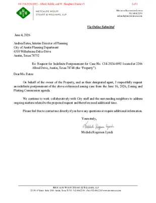
MICHELE ROGERSON LYNCH 512.404.2251 mlynch@mwswtexas.com Via Online Submittal June 4, 2026 Andrea Bates, Interim Director of Planning City of Austin Planning Department 6310 Wilhelmina Delco Drive Austin, Texas 78752 Re: Request for Indefinite Postponement for Case No. C14-2024-0092 located at 2206 Allred Drive, Austin, Texas 78748 (the “Property”) Dear Ms. Bates: On behalf of the owner of the Property, and as their designated agent, I respectfully request an indefinite postponement of the above-referenced zoning case from the June 16, 2026, Zoning and Platting Commission agenda. We continue to work collaboratively with City staff and the surrounding neighbors to address ongoing matters related to the proposed request and therefore need additional time. Please feel free to contact me directly if you have any questions or require additional information. Yours truly, Michele Rogerson Lynch METCALFE WOLFF STUART & WILLIAMS, LLP 221 W. 6th Street ·Suite 1300 ·Austin, Texas 78701 ·512.404.2200 · (Fax) 512.404.2245 www.mwswtexas.com 04 C14-2024-0092 - Allred, Riddle, and W. Slaughter; District 51 of 1
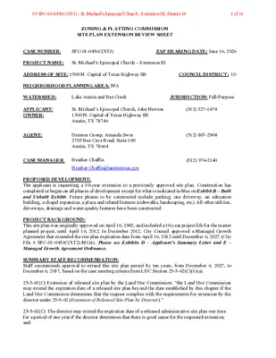
ZONING & PLATTING COMMISSION SITE PLAN EXTENSION REVIEW SHEET CASE NUMBER: SPC-01-0456C(XT3) ZAP HEARING DATE: June 16, 2026 PROJECT NAME: St. Michael’s Episcopal Church – Extension III ADDRESS OF SITE: 1500 N. Capital of Texas Highway SB COUNCIL DISTRICT: 10 NEIGHBORHOOD PLANNING AREA: N/A WATERSHED: Lake Austin and Bee Creek JURISDICTION: Full-Purpose APPLICANT/ OWNER: St. Michael’s Episcopal Church, John Newton 1500 N. Capital of Texas Highway SB Austin, TX 78746 AGENT: Drenner Group, Amanda Swor 2705 Bee Cave Road, Suite 100 Austin, TX 78664 (512) 327-1474 (512) 807-2904 CASE MANAGER: Heather Chaffin (512) 974-2140 Heather.Chaffin@austintexas.gov PROPOSED DEVELOPMENT: The applicant is requesting a 10-year extension to a previously approved site plan. Construction has completed or begun on all phases of development except for what is indicated in blue on Exhibit B – Built and Unbuilt Exhibit. Future phases to be constructed include parking, one driveway, an education building, a chapel expansion, a plaza and related features (sidewalks, landscaping, etc.) All other utilities, driveways, drainage and water quality features have been constructed. PROJECT BACKGROUND: This site plan was originally approved on April 16, 2002, and included a 10-year project life for the master planned project, until April 16, 2012. In December 2012, City Council approved a Managed Growth Agreement that extended the site plan expiration date from April 16, 2012 until December 6, 2027 (City File # SPC-01-0456C(XT2).MGA). Please see Exhibits D – Applicant’s Summary Letter and E – Managed Growth Agreement Ordinance. SUMMARY STAFF RECOMMENDATION: Staff recommends approval to extend this site plan permit by ten years, from December 6, 2027, to December 6, 2037, based on the case meeting criteria from LDC Section 25-5-62(C)(1)(a). 25-5-63(C) Extension of released site plan by the Land Use Commission: “the Land Use Commission may extend the expiration date of a released site plan beyond the date established by this chapter if the Land Use Commission determines that the request complies with the requirements for extension by the director under 25-5-62 (Extension of Released Site Plan by Director).” 25-5-62(C) The director may extend the expiration date of a released administrative site plan one time for a period of one year if the director determines that there is good cause for the requested extension; and: 05 SPC-01-0456C(XT3) - St. Michael's Episcopal Church - Extension III; District 101 of 16 (1) the director determines that: a) the site plan substantially complies with the requirements that apply to …
ZONING AND PLATTING COMMISSION MEETING MINUTES Tuesday, June 2, 2026 ZONING AND PLATTING COMMISSION REGULAR MEETING TUESDAY, JUNE 2, 2026 MEETING MINUTES The Zoning and Platting Commission convened in a regular meeting on Tuesday, June 2, 2026, at Austin City Hall, Council Chambers, Room 1001, 301 W. Second Street, in Austin, Texas. Chair Smith called the Zoning and Platting Meeting to order at 6:00 p.m. Commissioners in Attendance: Hank Smith Betsy Greenberg Ryan Puzycki Andrew Cortes David Fouts Luis Osta Lugo Commissioners in Attendance Remotely: Christian Tschoepe Lonny Stern Commissioners Absent: Alejandra Flores Scott Boone Taylor Major PUBLIC COMMUNICATION: GENERAL None present. APPROVAL OF MINUTES 1. Approve the minutes of the Zoning and Platting Commission regular meeting on Tuesday, May 19, 2026. The minutes from the meeting of Tuesday, May 19, 2026, were approved on the consent agenda, on Chair Smith’s motion, Vice Chair Greenberg’s second, on an 8-0 vote. Parliamentarian Flores, Commissioner Boone, and Commissioner Major were absent. 1 ZONING AND PLATTING COMMISSION MEETING MINUTES Tuesday, June 2, 2026 PUBLIC HEARINGS 2 Rezoning: Location: Owner/Applicant: Agent: Request: Staff Rec.: Staff: C14-2026-0001 - 3416 Davis Lane; District 5 3416 Davis Lane, Williamson Creek 3416 Davis Lane AGV LLC Armbrust & Brown, PLLC (Michael J. Whellan) GR-CO to GR-CO, to change conditions of zoning Recommended Reese McMichael, 512-974-7633, reese.mcmichael@austintexas.gov Austin Planning The public hearing was closed on Secreary Puzycki’s motion, Commissioner Fouts’ second, on an 8-0 vote. Parliamentarian Flores, Commissioner Boone, and Commissioner Major were absent. The motion to approve a conditional use permit failed on Vice Chair Greenberg’s motion, Commissioner Stern’s second, on a 4-4 vote. Those voting aye were Vice Chair Greenberg, and Commissioners Fouts, Stern, and Tschoepe. Those voting nay were Chair Smith, Secretary Puzycki, and Commissioners Cortes and Osta Lugo. Parliamentarian Flores, Commissioner Boone, and Commissioner Major were absent. The motion to approve Staff’s recommendation of GR-CO, to change conditions of zoning, for C14-2026-0001 - 3416 Davis Lane; District 5, located at 3416 Davis Lane, was approved on Commissioner Osta Lugo’s motion, Commissioner Cortes’ second, on a 6-2 vote. Vice Chair Greenberg and Commissioner Stern voted nay. Parliamentarian Flores, Commissioner Boone, and Commissioner Major were absent. 3. Extension of Time: SP-2017-0248C(XT3) - Deerfield Lane 1C; District 8 3601 Davis Lane, Williamson Creek Location: Owner/Applicant: WW Deerfield LTD/Waters Southwest Agent: Request: LJA Engineering, Inc. (Reese Hurley, PE) The applicant is requesting a three-year extension from March 1, 2026 …
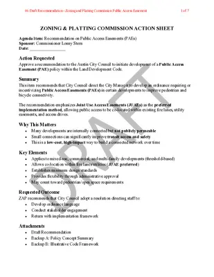
ZONING & PLATTING COMMISSION ACTION SHEET Agenda Item: Recommendation on Public Access Easements (PAEs) Sponsor: Commissioner Lonny Stern Date: _________________ Action Requested Approve a recommendation to the Austin City Council to initiate development of a Public Access Easement (PAE) policy within the Land Development Code. Summary This item recommends that City Council direct the City Manager to develop an ordinance requiring or incentivizing Public Access Easements (PAEs) in certain developments to improve pedestrian and bicycle connectivity. The recommendation emphasizes Joint Use Access Easements (JUAEs) as the preferred implementation method, allowing public access to be co-located within existing fire lanes, utility easements, and access drives. Why This Matters • Many developments are internally connected but not publicly permeable Small connections can significantly improve transit access and safety • • This is a low-cost, high-impact way to build a connected network over time Key Elements • Applies to mixed-use, commercial, and multi-family developments (threshold-based) • Allows co-location within fire lanes/utilities (JUAE preferred) • Establishes minimum design standards • Provides flexibility through administrative approval • May count toward pedestrian/open space requirements Requested Outcome ZAP recommends that City Council adopt a resolution directing staff to: • Develop ordinance language • Conduct stakeholder engagement • Return with implementation framework Attachments • Draft Recommendation • Backup A: Policy Concept Summary • Backup B: Illustrative Code Framework 06 Draft Recommendation - Zoning and Platting Commission Public Access Easement1 of 7 A Recommendation for Public Access Easements in New Development WHEREAS The Zoning & Platting Commission (ZAP) recognizes that Austin’s continued growth presents both challenges and opportunities to improve connectivity, safety, and access for people traveling by foot, bicycle, and transit; and WHEREAS many mixed-use, commercial, and multi-family developments include internal circulation elements such as fire lanes, utility easements, and private access ways that could provide meaningful public connections if made accessible; and WHEREAS gaps in connectivity between parcels, streets, trails, and transit stops contribute to longer travel distances, reduced safety, and limited access to mobility options; and WHEREAS cities across the United States have successfully implemented public access easement requirements to expand pedestrian networks and improve multimodal access without requiring full public right-of-way dedication; and WHEREAS the Commission finds that requiring or incentivizing Public Access Easements (PAEs)— particularly when co-located within Joint Use Access Easements (JUAEs)—can provide significant public benefit while minimizing impacts to development feasibility; WHEREAS large development sites without publicly accessible through-connections may create “superblock” …
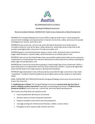
. RECOMMENDATION TO COUNCIL Zoning and Platting Commission Recommendation Number: 20260616-06: Public Access Easements in New Development WHEREAS The Zoning & Platting Commission (ZAP) recognizes that Austin’s continued growth presents both challenges and opportunities to improve connectivity, safety, and access for people traveling by foot, bicycle, and transit; and WHEREAS many mixed-use, commercial, and multi-family developments include internal circulation elements such as fire lanes, utility easements, and private access ways that could provide meaningful public connections if made accessible; and WHEREAS gaps in connectivity between parcels, streets, trails, and transit stops contribute to longer travel distances, reduced safety, and limited access to mobility options; and WHEREAS cities across the United States have successfully implemented public access easement requirements to expand pedestrian networks and improve multimodal access without requiring full public right-of-way dedication; and WHEREAS the Commission finds that requiring or incentivizing Public Access Easements (PAEs)— particularly when co-located within Joint Use Access Easements (JUAEs)—can provide significant public benefit while minimizing impacts to development feasibility; WHEREAS large development sites without publicly accessible through-connections may create “superblock” conditions that limit pedestrian permeability and increase reliance on automobile travel; NOW, THEREFORE, BE IT RESOLVED that the Zoning and Platting Commission recommends the Austin City Council to: 1. Establishment of Need. The Zoning & Platting Commission recommends that the City of Austin establish a policy framework requiring or incentivizing the provision of Public Access Easements (PAEs) in new mixed-use, commercial, and multi-family developments. The Commission finds that such a policy would: • Improve pedestrian and bicycle connectivity • Enhance access to transit and public amenities • Support complete communities and compact growth • Leverage existing site infrastructure (fire lanes, utilities, access drives) • Strengthen Austin’s public realm network over time . 2. Direction to City Council. The Zoning & Platting Commission recommends that the Austin City Council adopt a resolution directing the City Manager to: • Develop a proposed ordinance amending the Land Development Code to establish Public Access Easement requirements; • Evaluate thresholds for applicability (e.g., mixed-use, commercial square footage, multifamily unit counts); • Develop design, safety, and accessibility standards; • Evaluate existing block length, pedestrian circulation, and connectivity provisions within Subchapter E and determine whether similar principles should apply to internal site permeability and through-site pedestrian access; • Establish administrative criteria and enforcement mechanisms; • Identify incentives or offsets to support implementation; and • Conduct stakeholder engagement with developers, neighborhood groups, and …
REGULAR MEETING OF THE ZONING AND PLATTING COMMISSION TUESDAY, JUNE 2, 2026, AT 6 P.M. AUSTIN CITY HALL, COUNCIL CHAMBERS, ROOM 1001 301 WEST 2ND STREET AUSTIN, TEXAS Some members of the Zoning and Platting Commission may be participating by videoconference. The meeting may be viewed online at: http://www.austintexas.gov/page/watch-atxn-live Public comment will be allowed in-person or remotely via telephone. Speakers may only register to speak on an item once either in-person or remotely and will be allowed up to three minutes to provide their comments. Registration no later than 2 p.m. on the day of the meeting is required for remote participation by telephone. To register to speak remotely, please use the QR code or link at the end of this document. If you have questions regarding speaker registration, please contact Ella Garcia, Staff Liaison, at LandUseLiaison@austintexas.gov or by phone at 512-978-0821. CURRENT COMMISSIONERS: Hank Smith, Chair (District 8) Betsy Greenberg, Vice Chair (District 10) Ryan Puzycki, Secretary (District 7) Alejandra Flores, Parliamentarian (District 5) Luis Osta Lugo (Mayor’s Representative) Scott Boone (District 1) David Fouts (District 2) Lonny Stern (District 3) Andrew Cortes (District 4) Christian Tschoepe (District 6) Taylor Major (District 9) Staff Liaison: Ella Garcia, 512-978-0821 Attorney: Steve Maddoux, 512-974-6080 Page 1 of 5 AGENDA CALL TO ORDER PUBLIC COMMUNICATION: GENERAL The first four speakers signed up prior to the meeting being called to order will each be allowed a three-minute allotment to address their concerns regarding items not posted on the agenda. APPROVAL OF MINUTES 1. Approve the minutes of the Zoning and Platting Commission regular meeting on Tuesday, May 19, 2026. PUBLIC HEARINGS C14-2026-0001 - 3416 Davis Lane; District 5 3416 Davis Lane, Williamson Creek 2. Rezoning: Location: Owner/Applicant: 3416 Davis Lane AGV LLC Agent: Request: Staff Rec.: Staff: Armbrust & Brown, PLLC (Michael J. Whellan) GR-CO to GR-CO, to change conditions of zoning Recommended Reese McMichael, 512-974-7633, reese.mcmichael@austintexas.gov Austin Planning 3. Extension of Time: SP-2017-0248C(XT3) - Deerfield Lane 1C; District 8 3601 Davis Lane, Williamson Creek Location: Owner/Applicant: WW Deerfield LTD/Waters Southwest Agent: Request: LJA Engineering, Inc. (Reese Hurley, PE) The applicant is requesting a three-year extension from March 1, 2026 to March 1, 2029 Recommended Christine Barton-Holmes, 512-974-2788, christine.barton- holmes@austintexas.gov Austin Development Services Staff Rec.: Staff: DISCUSSION AND ACTION ITEM 4. Discussion and action to approve a recommendation to the Austin City Council regarding the division of responsibilities between the Zoning and Platting …
SPEAKER REGISTRATION All participants wishing to address the commission must register to speak. Public participation is available by teleconference or in-person. Presentations and handouts are requested to be e- mailed by 1:00 p.m. on the day of the meeting. TELECONFERNCE REGISTRATION Registration for participation by teleconference closes at 2:00 p.m., the day of the meeting. Teleconference code and additional information to be provided after the closing of the teleconference registration period. IN-PERSON REGISTRATION While in-person registrants are encouraged to register in advance of the meeting, in-person registration closes at 5:30 p.m., the day of the meeting. Please scan the QR code below with a mobile device or click on the link below. Mobile devices will also be available at the meeting for public use for the purpose of speaker registration. SPEAKER DONATION OF TIME For discussion cases, speaker donation of time is an available option for in-person participants. Both the registered speaker donating time and the speaker recipient must be present when the public hearing is conducted. See chart below regarding speaker time allotments. SPEAKING ORDER The speaking order is determined by the order in which individuals register to speak and is conducted on a first-come, first-served basis. If multiple speakers register as the Primary Speaker, the first to register is allotted the additional speaking time. Participants who are part of a group or organization and wish to request a specific speaking order must contact Ella Garcia, Staff Liaison, at LandUseLiaison@austintexas.gov or 512-978-0821 as soon as possible, and no later than 2:00 p.m. on the day of the meeting. Click on the link below or scan the QR code and submit the form to register to speak. Speakers should submit a separate registration form for each item of interest. https://forms.office.com/g/Ash1EsNFf4 SPEAKER TESTIMONY TIME ALLOCATION PUBLIC HEARING Speaker Number Time Allocated Total Time Allocated Applicant/Agent or primary speaker in favor Primary speaker in opposition 1 1 6 minutes 12 minutes (with donated time, including 3-minute rebuttal) 6 minutes 9 minutes (with donated time) All other speakers in favor or opposition Unlimited 3 minutes 6 minutes (with donated time) All speakers are allowed three (3) minutes of donated time from a speaker present during the Public Hearing.
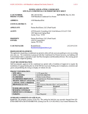
ZONING AND PLATTING COMMISSION MEETING MINUTES Tuesday, May 19, 2026 ZONING AND PLATTING COMMISSION REGULAR MEETING MEETING MINUTES TUESDAY, MAY 19, 2026 The Zoning and Platting Commission convened in a regular meeting on Tuesday, May 19, 2026, at Austin City Hall, Council Chambers, Room 1001, 301 W. Second Street, in Austin, Texas. Chair Smith called the Zoning and Platting Meeting to order at 6:00 p.m. Commissioners in Attendance: Hank Smith Betsy Greenberg Ryan Puzycki Andrew Cortes Commissioners in Attendance Remotely: David Fouts Taylor Major Christian Tschoepe Commissioners Absent: Alejandra Flores Scott Boone Luis Osta Lugo Lonny Stern PUBLIC COMMUNICATION: GENERAL None present. APPROVAL OF MINUTES 1. Approve the minutes of the Zoning and Platting Commission regular meeting on Tuesday, May 5, 2026. The minutes from the meeting of Tuesday, May 5, 2026, were approved on the consent agenda, on Secretary Puzycki’s motion, Commissioner Fouts’ second, on a 7-0 vote. Parliamentarian Flores and Commissioners Boone, Osta Lugo, Major, and Tschoepe were absent. 1 ZONING AND PLATTING COMMISSION MEETING MINUTES Tuesday, May 19, 2026 PUBLIC HEARINGS 2. Rezoning: C14-2026-0021 - Round Rock ISD Career & Technical Education Center; District 6 9900 Spectrum Drive, Lake Creek Location: Owner/Applicant: Dennis Covington Agent: Request: Staff Rec.: Staff: Civilitude (Kyle Moore, P.E.) IP-PDA to IP-PDA, to change conditions of zoning Recommended Sherri Sirwaitis, 512-974-3057, sherri.sirwaitis@austintexas.gov Austin Planning The motion to approve Staff’s recommendation of IP-PDA, to change conditions of zoning, for C14-2026-0021 - Round Rock ISD Career & Technical Education Center; District 6, located at 9900 Spectrum Drive, was approved on the consent agenda, on Secretary Puzycki’s motion, Commissioner Fouts’ second, on a 7-0 vote. Parliamentarian Flores and Commissioners Boone, Osta Lugo, Major, and Tschoepe were absent. 3. Rezoning: Location: Owner/Applicant: Agent: Request: Staff Rec.: Staff: C14-2026-0023 - 8863 Anderson Mill Road; District 6 8863 Anderson Mill Road, Lake Creek Third NHP Holdings, LP (Nelson H. Puett GP) Nelson Puett Real Estate (Shawna Sigala) I-RR, GR-CO to GR-CO Recommended Sherri Sirwaitis, 512-974-3057, sherri.sirwaitis@austintexas.gov Austin Planning The motion to approve Staff’s recommendation of GR-CO for C14-2026-0023 - 8863 Anderson Mill Road; District 6, located at 8863 Anderson Mill Road, was approved on the consent agenda, on Secretary Puzycki’s motion, Commissioner Fouts’ second, on a 7-0 vote. Parliamentarian Flores and Commissioners Boone, Osta Lugo, Major, and Tschoepe were absent. 4. Conditional Use SPC-2025-0320A - 4109 Marathon Conditional Use Permit; District 10 Permit: Location: Owner/Applicant: Agent: Request: Staff Rec.: …
ZONING AND PLATTING COMMISSION MEETING MINUTES Tuesday, May 19, 2026 ZONING AND PLATTING COMMISSION REGULAR MEETING MEETING MINUTES TUESDAY, MAY 19, 2026 The Zoning and Platting Commission convened in a regular meeting on Tuesday, May 19, 2026, at Austin City Hall, Council Chambers, Room 1001, 301 W. Second Street, in Austin, Texas. Chair Smith called the Zoning and Platting Meeting to order at 6:00 p.m. Commissioners in Attendance: Hank Smith Betsy Greenberg Ryan Puzycki Andrew Cortes Commissioners in Attendance Remotely: David Fouts Taylor Major Christian Tschoepe Commissioners Absent: Alejandra Flores Scott Boone Luis Osta Lugo Lonny Stern PUBLIC COMMUNICATION: GENERAL None present. APPROVAL OF MINUTES 1. Approve the minutes of the Zoning and Platting Commission regular meeting on Tuesday, May 5, 2026. The minutes from the meeting of Tuesday, May 5, 2026, were approved on the consent agenda, on Secretary Puzycki’s motion, Commissioner Fouts’ second, on a 7-0 vote. Parliamentarian Flores and Commissioners Boone, Osta Lugo, and Stern were absent. 1 ZONING AND PLATTING COMMISSION MEETING MINUTES Tuesday, May 19, 2026 PUBLIC HEARINGS 2. Rezoning: C14-2026-0021 - Round Rock ISD Career & Technical Education Center; District 6 9900 Spectrum Drive, Lake Creek Location: Owner/Applicant: Dennis Covington Agent: Request: Staff Rec.: Staff: Civilitude (Kyle Moore, P.E.) IP-PDA to IP-PDA, to change conditions of zoning Recommended Sherri Sirwaitis, 512-974-3057, sherri.sirwaitis@austintexas.gov Austin Planning The motion to approve Staff’s recommendation of IP-PDA, to change conditions of zoning, for C14-2026-0021 - Round Rock ISD Career & Technical Education Center; District 6, located at 9900 Spectrum Drive, was approved on the consent agenda, on Secretary Puzycki’s motion, Commissioner Fouts’ second, on a 7-0 vote. Parliamentarian Flores and Commissioners Boone, Osta Lugo, and Stern were absent. 3. Rezoning: Location: Owner/Applicant: Agent: Request: Staff Rec.: Staff: C14-2026-0023 - 8863 Anderson Mill Road; District 6 8863 Anderson Mill Road, Lake Creek Third NHP Holdings, LP (Nelson H. Puett GP) Nelson Puett Real Estate (Shawna Sigala) I-RR, GR-CO to GR-CO Recommended Sherri Sirwaitis, 512-974-3057, sherri.sirwaitis@austintexas.gov Austin Planning The motion to approve Staff’s recommendation of GR-CO for C14-2026-0023 - 8863 Anderson Mill Road; District 6, located at 8863 Anderson Mill Road, was approved on the consent agenda, on Secretary Puzycki’s motion, Commissioner Fouts’ second, on a 7-0 vote. Parliamentarian Flores and Commissioners Boone, Osta Lugo, and Stern were absent. 4. Conditional Use SPC-2025-0320A - 4109 Marathon Conditional Use Permit; District 10 Permit: Location: Owner/Applicant: Agent: Request: Staff Rec.: Staff: 4109 Marathon …
ZONING CHANGE REVIEW SHEET CASE: C14-2026-0001 – 3416 Davis Lane DISTRICT: 5 ADDRESS: 3416 Davis Lane ZONING FROM: GR-CO TO: GR-CO, to change a condition of zoning SITE AREA: 7.31 acres PROPERTY OWNER: 3416 Davis Lane AGV, LLC AGENT: Armburst & Brown, PLLC (Michael Whellan) CASE MANAGER: Reese McMichael (512-974-7633, reese.mcmichael@austintexas.gov) STAFF RECOMMEDATION: The Staff recommendation is to grant community commercial – conditional overlay (GR-CO) combining district zoning, to change a condition of zoning. The conditional overlay will be amended to allow drive-in service as an accessory use to commercial uses. All other portions of the conditional overlay will remain unchanged. ZONING & PLATTING COMMISSION ACTION / RECOMMENDATION: June 2, 2026 CITY COUNCIL ACTION: ORDINANCE NUMBER: ISSUES: None at this time CASE MANAGER COMMENTS: The subject rezoning area consists of approximately 7.31 acres located at the northeast corner of the intersection of Davis Lane and Brodie Lane. This site is currently undeveloped, while the current zoning district of this property, established in 2001 by Ordinance No. 011004-12, is Community Commercial – Conditional Overlay (GR-CO); the conditional overlay in effect for this property establishes floor-to-area ratio caps, restrictions on certain uses, and a 02 C14-2026-0001 - 3416 Davis Lane; District 51 of 13 prohibition on drive-in service as an accessory use to commercial uses. Please refer to Exhibit D (Ordinance No. 011004-12). Adjacent land uses consists of multifamily residences and undeveloped land to the east, multifamily residences to the north, single family residences and commercial uses to the south, and open space and multifamily residences to the west. Please refer to Exhibits A (Zoning Map) and B (Aerial View). As for the transportation context of the larger vicinity surrounding this property, the Austin Strategic Mobility Plan (ASMP) identifies Davis Lane as a level 2 street, while Brodie Lane is established as a level 3 street. This property is approximately one mile north of the intersection of Slaughter Lane, an Imagine Austin corridor, and Brodie Lane. The applicant is requesting that the prohibition on drive-in service as an accessory use to commercial uses be removed from the conditional overlay. This would allow the applicant to provide neighborhood-serving commercial uses which could include a low-intensity drive- through accessory use. Staff is recommending Community Commercial – Conditional Overlay (GR-CO) combining district zoning with the modification to the conditional overlay because of the site’s proximity to Brodie Lane - a major corridor, and Davis Lane …
ZONING & PLATTING COMMISSION SITE PLAN EXTENSION REVIEW SHEET CASE NUMBER: SP-2017-0248C(XT3) ZAP HEARING DATE: June 2, 2026 PROJECT NAME: Deerfield Lot 1C ADDRESS OF SITE: 3601 Davis Lane COUNCIL DISTRICT: 8 NEIGHBORHOOD PLANNING AREA: N/A WATERSHED: Williamson Creek JURISDICTION: Full-Purpose APPLICANT/ OWNER: AGENT: WW Deerfield LTD % Walters Southwest 1010 W. MLK Jr. Blvd Austin, TX 78701 LJA Engineering, Inc., Reese Hurley, PE 7500 Rialto Blvd., Bldg. 2, Ste. 100 Austin, TX 78735 (512) 964-7772 (512) 439-4700 CASE MANAGER: Christine Barton-Holmes christine.barton- (512) 974-2788 holmes@austintexas.gov PROPOSED DEVELOPMENT: The applicant is requesting a three-year extension to a previously approved site plan. Construction has completed or begun on all phases of development except for what is indicated on Lot 1C-A of the overall Deerfield Lot 1C site plan. Construction on Lot 1C-A includes common site drives, utilities, and the proposed building footprint for restaurant and retail uses. SUMMARY STAFF RECOMMENDATION: Staff recommends approval to extend this site plan permit by three years, from March 1, 2026 to March 1, 2029 based on the case meeting criteria from LDC Section 25-5-62(C)(1)(a). 25-5-63(C) Extension of released site plan by the Land Use Commission: “the Land Use Commission may extend the expiration date of a released site plan beyond the date established by this chapter if the Land Use Commission determines that the request complies with the requirements for extension by the director under 25-5-62 (Extension of Released Site Plan by Director).” 25-5-62(C) The director may extend the expiration date of a released administrative site plan one time for a period of one year if the director determines that there is good cause for the requested extension; and (1) the director determines that: a) the site plan substantially complies with the requirements that apply to a new application for site plan approval; b) the applicant filed the original application for site plan approval with the good faith expectation that the site plan would be constructed; c) the applicant constructed at least one structure shown on the original site plan that is suitable for permanent occupancy; or d) the applicant has constructed a significant portion of the infrastructure required for development of the original site plan; 03 SP-2017-0248C(XT3) - Deerfield Lane 1C; District 81 of 11 SUMMARY OF SITE PLAN: LAND USE: The site is zoned LR and GR-CO. All site calculations are within the allowed amount. ENVIRONMENTAL: All environmental comments have been cleared. TRANSPORTATION: …
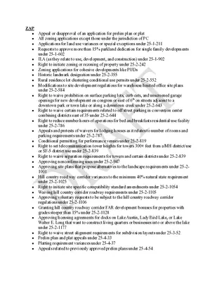
ZAP • Appeal or disapproval of an application for prelim plan or plat • All zoning applications except those under the jurisdiction of PC • Applications for land use variances or special exceptions under 25-1-211 • Requests to approve more than 15% parkland dedication for single family developments under 25-1-602 ILA (as they relate to use, development, and construction) under 25-1-902 • • Right to initiate zoning or rezoning of property under 25-2-242 • Zoning applications for cohesive developments like PUDs • Historic landmark designation under 25-2-355 • Rural residence lot clustering conditional use permits under 25-2-552 • Modifications to site development regulations for warehouse/limited office site plans under 25-2-584 • Right to waive prohibition on surface parking lots, curb cuts, and unscreened garage openings for new development on congress or east of 6th on streets adjacent to a downtown park or town lake or along a downtown creek under 25-2-643 • Right to waive certain requirements related to off street parking in convention center combining districts east of 35 under 25-2-644 • Right to reduce number hours of operations for bed and breakfasts residential use facility under 25-2-786 • Appeals and protests of waivers for lodging houses as it relates to number of rooms and parking requirements under 25-2-787 • Conditional permitting for performance venues under 25-2-819 • Right to set telecommunication tower heights for towers 300+ feet from a MH district/use or SF-5 district/use under 25-2-839 • Right to waive separation requirements for towers and certain districts under 25-2-839 • Approving nonconforming uses under 25-2-947 • Approving site plans that propose alternatives to the landscape requirements under 25-2- 1001 • Hill country road way corridor variances to the minimum 40% natural state requirement under 25-2-1025 • Right to initiate site specific compatibility standard amendments under 25-2-1054 • Waiving hill country corridor roadway requirements under 25-2-1105 • Approving voluntary requests to be subject to the hill country roadway corridor regulations under 25-2-1106 • Granting hill country roadway corridor FAR development bonuses for properties with grades steeper than 15% under 25-2-1128 • Approving licensing agreements for docks on Lake Austin, Lady Bird Lake, or Lake Walter E. Long that want to construct living quarters or businesses into or above the lake under 25-2-1177 • Right to waive street alignment requirements for subdivision layouts under 25-3-52 • Prelim plan and plat appeals under 25-4-33 • Platting requirement variances under 25-4-37 • …
ZONING AND PLATTING COMMISSION MEETING MINUTES Tuesday, June 2, 2026 ZONING AND PLATTING COMMISSION REGULAR MEETING TUESDAY, JUNE 2, 2026 MEETING MINUTES The Zoning and Platting Commission convened in a regular meeting on Tuesday, June 2, 2026, at Austin City Hall, Council Chambers, Room 1001, 301 W. Second Street, in Austin, Texas. Chair Smith called the Zoning and Platting Meeting to order at 6:00 p.m. Commissioners in Attendance: Hank Smith Betsy Greenberg Ryan Puzycki Andrew Cortes David Fouts Luis Osta Lugo Commissioners in Attendance Remotely: Christian Tschoepe Lonny Stern Commissioners Absent: Alejandra Flores Scott Boone Taylor Major PUBLIC COMMUNICATION: GENERAL None present. APPROVAL OF MINUTES 1. Approve the minutes of the Zoning and Platting Commission regular meeting on Tuesday, May 19, 2026. The minutes from the meeting of Tuesday, May 19, 2026, were approved on the consent agenda, on Chair Smith’s motion, Vice Chair Greenberg’s second, on an 8-0 vote. Parliamentarian Flores, Commissioner Boone, and Commissioner Major were absent. 1 ZONING AND PLATTING COMMISSION MEETING MINUTES Tuesday, June 2, 2026 PUBLIC HEARINGS 2 Rezoning: Location: Owner/Applicant: Agent: Request: Staff Rec.: Staff: C14-2026-0001 - 3416 Davis Lane; District 5 3416 Davis Lane, Williamson Creek 3416 Davis Lane AGV LLC Armbrust & Brown, PLLC (Michael J. Whellan) GR-CO to GR-CO, to change conditions of zoning Recommended Reese McMichael, 512-974-7633, reese.mcmichael@austintexas.gov Austin Planning The public hearing was closed on Secreary Puzycki’s motion, Commissioner Fouts’ second, on an 8-0 vote. Parliamentarian Flores, Commissioner Boone, and Commissioner Major were absent. The motion to approve a conditional use permit failed on Vice Chair Greenberg’s motion, Commissioner Stern’s second, on a 4-4 vote. Those voting aye were Vice Chair Greenberg, and Commissioners Fouts, Stern, and Tschoepe. Those voting nay were Chair Smith, Secretary Puzycki, and Commissioners Cortes and Osta Lugo. Parliamentarian Flores, Commissioner Boone, and Commissioner Major were absent. The motion to approve Staff’s recommendation of GR-CO, to change conditions of zoning, for C14-2026-0001 - 3416 Davis Lane; District 5, located at 3416 Davis Lane, was approved on Commissioner Osta Lugo’s motion, Commissioner Cortes’ second, on a 6-2 vote. Vice Chair Greenberg and Commissioner Stern voted nay. Parliamentarian Flores, Commissioner Boone, and Commissioner Major were absent. 3. Extension of Time: SP-2017-0248C(XT3) - Deerfield Lane 1C; District 8 3601 Davis Lane, Williamson Creek Location: Owner/Applicant: WW Deerfield LTD/Waters Southwest Agent: Request: LJA Engineering, Inc. (Reese Hurley, PE) The applicant is requesting a three-year extension from March 1, 2026 …
REGULAR MEETING OF THE ZONING AND PLATTING COMMISSION TUESDAY, MAY 19, 2026, AT 6 P.M. AUSTIN CITY HALL, COUNCIL CHAMBERS, ROOM 1001 301 WEST 2ND STREET AUSTIN, TEXAS Some members of the Zoning and Platting Commission may be participating by videoconference. The meeting may be viewed online at: http://www.austintexas.gov/page/watch-atxn-live Public comment will be allowed in-person or remotely via telephone. Speakers may only register to speak on an item once either in-person or remotely and will be allowed up to three minutes to provide their comments. Registration no later than 2 p.m. on the day of the meeting is required for remote participation by telephone. To register to speak remotely, please use the QR code or link at the end of this document. If you have questions regarding speaker registration, please contact Ella Garcia, Staff Liaison, at LandUseLiaison@austintexas.gov or by phone at 512-978-0821. CURRENT COMMISSIONERS: Hank Smith, Chair (District 8) Betsy Greenberg, Vice Chair (District 10) Ryan Puzycki, Secretary (District 7) Alejandra Flores, Parliamentarian (District 5) Luis Osta Lugo (Mayor’s Representative) Scott Boone (District 1) David Fouts (District 2) Lonny Stern (District 3) Andrew Cortes (District 4) Christian Tschoepe (District 6) Taylor Major (District 9) Staff Liaison: Ella Garcia, 512-978-0821 Attorney: Jenna Schwartz, 512-978-0871 Page 1 of 5 AGENDA CALL TO ORDER PUBLIC COMMUNICATION: GENERAL The first four speakers signed up prior to the meeting being called to order will each be allowed a three-minute allotment to address their concerns regarding items not posted on the agenda. APPROVAL OF MINUTES 1. Approve the minutes of the Zoning and Platting Commission regular meeting on Tuesday, May 5, 2026. PUBLIC HEARINGS 2. Rezoning: C14-2026-0021 - Round Rock ISD Career & Technical Education Center; District 6 9900 Spectrum Drive, Lake Creek Location: Owner/Applicant: Dennis Covington Agent: Request: Staff Rec.: Staff: Civilitude (Kyle Moore, P.E.) IP-PDA to IP-PDA, to change conditions of zoning Recommended Sherri Sirwaitis, 512-974-3057, sherri.sirwaitis@austintexas.gov Austin Planning C14-2026-0023 - 8863 Anderson Mill Road; District 6 8863 Anderson Mill Road, Lake Creek 3. Rezoning: Location: Owner/Applicant: Third NHP Holdings, LP (Nelson H. Puett GP) Agent: Request: Staff Rec.: Staff: Nelson Puett Real Estate (Shawna Sigala) I-RR, GR-CO to GR-CO Recommended Sherri Sirwaitis, 512-974-3057, sherri.sirwaitis@austintexas.gov Austin Planning 4. Conditional Use Permit: SPC-2025-0320A - 4109 Marathon Conditional Use Permit; District 10 4109 Marathon Boulevard, Waller Creek Location: Owner/Applicant: Fadana Real Estate LLC (Fuad Fayad) Agent: Request: ATX Permit & Consulting, LLC (Lila Nelson) Conditional Use …
SPEAKER REGISTRATION All participants wishing to address the commission must register to speak. Public participation is available by teleconference or in-person. Presentations and handouts are requested to be e- mailed by 1:00 p.m. on the day of the meeting. TELECONFERNCE REGISTRATION Registration for participation by teleconference closes at 2:00 p.m., the day of the meeting. Teleconference code and additional information to be provided after the closing of the teleconference registration period. IN-PERSON REGISTRATION While in-person registrants are encouraged to register in advance of the meeting, in-person registration closes at 5:30 p.m., the day of the meeting. Please scan the QR code below with a mobile device or click on the link below. Mobile devices will also be available at the meeting for public use for the purpose of speaker registration. SPEAKER DONATION OF TIME For discussion cases, speaker donation of time is an available option for in-person participants. Both the registered speaker donating time and the speaker recipient must be present when the public hearing is conducted. See chart below regarding speaker time allotments. SPEAKING ORDER The speaking order is determined by the order in which individuals register to speak and is conducted on a first-come, first-served basis. If multiple speakers register as the Primary Speaker, the first to register is allotted the additional speaking time. Participants who are part of a group or organization and wish to request a specific speaking order must contact Ella Garcia, Staff Liaison, at LandUseLiaison@austintexas.gov or 512-978-0821 as soon as possible, and no later than 2:00 p.m. on the day of the meeting. Click on the link below or scan the QR code and submit the form to register to speak. Speakers should submit a separate registration form for each item of interest. https://forms.office.com/g/Ash1EsNFf4 SPEAKER TESTIMONY TIME ALLOCATION PUBLIC HEARING Speaker Number Time Allocated Total Time Allocated Applicant/Agent or primary speaker in favor Primary speaker in opposition 1 1 6 minutes 12 minutes (with donated time, including 3-minute rebuttal) 6 minutes 9 minutes (with donated time) All other speakers in favor or opposition Unlimited 3 minutes 6 minutes (with donated time) All speakers are allowed three (3) minutes of donated time from a speaker present during the Public Hearing.
ZONING CHANGE REVIEW SHEET CASE: C14-2026-0021 - Round Rock ISD Career & Technical Education Center - PDA Amendment DISTRICT: 6 ADDRESS: 9900 Spectrum Drive ZONING FROM: IP-PDA * The applicant is requesting to amend the existing planned development area (PDA) overlay to add Public Primary Educational Facilities, Public Secondary Educational Facilities, Administrative Services, and Childcare Services (General) as permitted uses of the property. TO: IP-PDA* SITE AREA: 48.79 acres PROPERTY OWNER: Dennis Covington APPLICANT/AGENT: Civilitude (Kyle Moore, P.E.) CASE MANAGER: Sherri Sirwaitis (512-974-3057, sherri.sirwaitis@austintexas.gov) STAFF RECOMMEDATION: Staff recommends IP-PDA, Industrial Park-Planned Development Combining District, zoning to change conditions of zoning. ZONING AND PLATTING COMMISSION ACTION / RECOMMENDATION: May 19, 2026 CITY COUNCIL ACTION: ORDINANCE NUMBER: 02 C14-2026-0021 - Round Rock ISD Career & Technical Education Center; District 61 of 11 C14-2026-0021 ISSUES: N/A CASE MANAGER COMMENTS: 2 The property in question is a 48+ acre office development, with two surface parking lots, zoned IP-PDA. There is floodplain (Davis Springs Branch Creek) and a detention pond zoned PUD to the north and a multifamily complex zoned MF-3-CO to the northeast. To the south, there is an office/warehouse center zoned IP-CO. The lots to the east contain detention zoned P and R&D and another multifamily development zoned MF-3. To the west, there is an office/manufacturing plan and undeveloped land zoned IP-PDA and IP respectively. In this rezoning request, the applicant is asking to amend the existing planned development area (PDA) to add Public Primary Educational Facilities, Public Secondary Educational Facilities, Administrative Services, and Childcare Services (General) as permitted uses of the property (please see Applicant’s Request Letter – Exhibit C). The applicant, Round Rock School District, recently purchased this 206,000-square-foot office facility, which was formally home to a legal services firm, to utilize this site as a districtwide center for career and technical education and innovation. It will house training for auto body, cosmetology, early childhood and electrical trades, among other uses that will include providing practice spaces for robotics teams. The staff recommends IP-PDA zoning, to amend the existing PDA conditions in Ordinance No. 931104-K, to permit Public Primary Educational Facilities, Public Secondary Educational Facilities, Administrative Services, and Childcare Services (General) on the property. The proposed zoning is consistent with the purpose of the base district and surrounding zoning patterns. There are commercial and industrial uses to the south, east and west of the site under consideration. The property fronts on …
ZONING CHANGE REVIEW SHEET CASE: C14-2026-0023 - 8863 Anderson Mill Road DISTRICT: 6 ADDRESS: 8863 Anderson Mill Road ZONING FROM: I-RR, GR-CO TO: GR-CO SITE AREA: 3.12 acres PROPERTY OWNER: Third NHP Holdings, LP (Nelson H. Puett GP) AGENT: Nelson Puett Real Estate (Shawna Sigala) CASE MANAGER: Sherri Sirwaitis (512-974-3057, sherri.sirwaitis@austintexas.gov) STAFF RECOMMEDATION: Staff recommends GR-CO, Community Commercial-Conditional Overlay Combining District, zoning. The conditional overlay will prohibit the following uses on the property: Automotive Repair Services, Automotive Sales, Automotive Washing (of any type), Bail Bond Services, Club or Lodge, Commercial Off-Street Parking, Drop Off Recycling Collection Facility, Exterminating Services, Funeral Services, Hotel/Motel, Off-Site Accessory Parking, Outdoor Entertainment, Outdoor Sports and Recreation, Pawn Shop Services and Service Station. ZONING AND PLATTING COMMISSION ACTION / RECOMMENDATION: May 19, 2026 CITY COUNCIL ACTION: ORDINANCE NUMBER: 03 C14-2026-0023 - 8863 Anderson Mill Road; District 61 of 20 C14-2026-0023 ISSUES: N/A CASE MANAGER COMMENTS: 2 The property in question is a suite developed with a commercial strip center that fronts Anderson Mill Road. The lots to the north, across Anderson Mill Road, contain single family residences currently designated I-SF-2. The tracts of land to the south and east are developed with public schools (Deer Park Middle School and Live Oak Elementary School) designated I-RR. To the west, there is an undeveloped tract of land and townhouse residences zoned LR- MU-CO. In this request, the applicant is asking to zone the property to GR-CO, Community Commercial-Conditional Overlay Combining District, zoning to bring the existing uses on the site into conformance with City of Austin Land Use regulations. The applicant proposes to maintain the current conditional overlay from the previous GR-CO zoning case for the restaurant footprint in this shopping center from zoning case C14-2022-0041 (please see Ordinance No. 20220728-135 - Exhibit C). The staff is recommending GR-CO, Community Commercial-Conditional Overlay District, zoning for the property under consideration. The proposed GR-CO zoning will allow for low intensity office and commercial uses on a lot that front onto an arterial roadway, Anderson Mill Road. GR-CO zoning will permit the applicant to develop and maintain limited commercial uses on a property adjacent to the residential neighborhoods to the north. The proposed zoning will permit the applicant to bring the existing uses on the site into conformance the land use regulations in the City of Austin Code. The applicant agrees with the staff’s recommendation. BASIS OF RECOMMENDATION: 1. The proposed …
ZONING AND PLATTING COMMISSION SITE PLAN CONDITIONAL USE PERMIT REVIEW SHEET CASE NUMBER: PROJECT NAME: SPC-2025-0320A 4109 Marathon Conditional Use Permit ZAP DATE: May 19, 2026 ADDRESS: 4109 Marathon Blvd COUNCIL DISTRICT: 10 APPLICANT: Fadana Real Estate, LLC (Fuad Fayad) AGENT: PROPERTY OWNER: ATX Permit & Consulting, LLC (Lila Nelson) (512) 657-7349 4408 Spicewood Spring Road Austin, Texas 78759 Fadana Real Estate, LLC (Fuad Fayad) 4108 N. Larmar Blvd Austin, TX 78756 CASE MANAGER: Randall Rouda Randall.Rouda@austintexas.gov (512) 978-3338 PROPOSED DEVELOPMENT: The applicant is requesting a conditional use permit to allow off-site accessory parking to serve an existing auto sales use. No construction is proposed with this Conditional Use Permit, however, one building will be demolished under a separately issued Site Plan Exemption and Demolition Permit. The existing paved surface will be striped for parking. STAFF RECOMMENDATION: Staff recommends approval of the conditional use permit with a Condition of Approval to require the installation of signage limiting the use of the Off-Site Accessory Parking area to employees, customers and guests and prohibiting the storage or display of vehicles for sale. PROJECT INFORMATION: SITE AREA: SITE’S ZONING WATERSHED WATERSHED ORDINANCE TRAFFIC IMPACT ANALYSIS Not required CAPITOL VIEW CORRIDOR PROPOSED ACCESS 7,579 square feet LR-ETOD-DBETOD Waller Creek (Urban) Comprehensive Watershed Ordinance FLOOR-AREA RATIO BUILDING COVERAGE IMPERVIOUS COVERAGE PARKING None Alley between Marathon Blvd. and Lamar Blvd. Allowed 0.5:1 50% 80% None Required 0:1 0% 80% 13 Proposed SUMMARY COMMENTS ON SITE PLAN: Land Use: The property consists of two lots. The zoning for both lots was recently changed from LO- ETOD-DBETOD to LR-ETOD-DBETOD. (Zoning Case No. C14-2025-0023, City Council Ordinance No. 04 SPC-2025-0320A - 4109 Marathon Conditional Use Permit; District 101 of 11 4109 Marathon CUP SPC-2025-0320A 2 20250522-075). The Site is currently 100% paved and contains an existing storage building with a footprint of approximately 6,853 square feet. No Construction is proposed with this Conditional Use Permit, however, a Site Plan Exemption and Demolition Permit have previously been issued for the demolition of the existing building and removal of approximately 1,580 square feet of pavement adjacent to Marathon Boulevard. If the Conditional Use Permit is approved, the remaining paved area will be striped for parking. Access to the parking lot would be from the alley to the east of the site, between Lamar Boulevard and Marathon Boulevard. The property to be served is an existing automobile sales use located across the …
ZAP • Appeal or disapproval of an application for prelim plan or plat • All zoning applications except those under the jurisdiction of PC • Applications for land use variances or special exceptions under 25-1-211 • Requests to approve more than 15% parkland dedication for single family developments under 25-1-602 ILA (as they relate to use, development, and construction) under 25-1-902 • • Right to initiate zoning or rezoning of property under 25-2-242 • Zoning applications for cohesive developments like PUDs • Historic landmark designation under 25-2-355 • Rural residence lot clustering conditional use permits under 25-2-552 • Modifications to site development regulations for warehouse/limited office site plans under 25-2-584 • Right to waive prohibition on surface parking lots, curb cuts, and unscreened garage openings for new development on congress or east of 6th on streets adjacent to a downtown park or town lake or along a downtown creek under 25-2-643 • Right to waive certain requirements related to off street parking in convention center combining districts east of 35 under 25-2-644 • Right to reduce number hours of operations for bed and breakfasts residential use facility under 25-2-786 • Appeals and protests of waivers for lodging houses as it relates to number of rooms and parking requirements under 25-2-787 • Conditional permitting for performance venues under 25-2-819 • Right to set telecommunication tower heights for towers 300+ feet from a MH district/use or SF-5 district/use under 25-2-839 • Right to waive separation requirements for towers and certain districts under 25-2-839 • Approving nonconforming uses under 25-2-947 • Approving site plans that propose alternatives to the landscape requirements under 25-2- 1001 • Hill country road way corridor variances to the minimum 40% natural state requirement under 25-2-1025 • Right to initiate site specific compatibility standard amendments under 25-2-1054 • Waiving hill country corridor roadway requirements under 25-2-1105 • Approving voluntary requests to be subject to the hill country roadway corridor regulations under 25-2-1106 • Granting hill country roadway corridor FAR development bonuses for properties with grades steeper than 15% under 25-2-1128 • Approving licensing agreements for docks on Lake Austin, Lady Bird Lake, or Lake Walter E. Long that want to construct living quarters or businesses into or above the lake under 25-2-1177 • Right to waive street alignment requirements for subdivision layouts under 25-3-52 • Prelim plan and plat appeals under 25-4-33 • Platting requirement variances under 25-4-37 • …
ZONING AND PLATTING COMMISSION MEETING MINUTES Tuesday, May 5, 2026 ZONING AND PLATTING COMMISSION REGULAR MEETING MEETING MINUTES TUESDAY, MAY 5, 2026 The Zoning and Platting Commission convened in a regular meeting on Tuesday, May 5, 2026, at Austin City Hall, Council Chambers, Room 1001, 301 W. Second Street, in Austin, Texas. Chair Smith called the Zoning and Platting Meeting to order at 6:00 p.m. Commissioners in Attendance: Hank Smith Betsy Greenberg Ryan Puzycki Alejandra Flores David Fouts Andrew Cortes Commissioners in Attendance Remotely: Scott Boone Lonny Stern Commissioners Absent: Luis Osta Lugo Taylor Major Christian Tschoepe PUBLIC COMMUNICATION: GENERAL None present. APPROVAL OF MINUTES 1. Approve the minutes of the Zoning and Platting Commission regular meeting on Tuesday, April 21, 2026. The minutes from the meeting of Tuesday, April 21, 2026, were approved on the consent agenda, on Parliamentarian Flores’ motion, Secretary Puzycki’s second, on an 8-0 vote. Commissioners Osta Lugo, Major, and Tschoepe were absent. 1 ZONING AND PLATTING COMMISSION MEETING MINUTES Tuesday, May 5, 2026 PUBLIC HEARINGS C14-2025-0112 - Lagos Austin West FM 973 Mixed Use; District 1 11716 ½ North FM 973 Road, Gilleland Creek Watershed 2. Rezoning: Location: Owner/Applicant: Wild Horse Creekside Commercial LP (Pete Dwyer) Kimley-Horn (Ethan Harwell) Agent: I-RR to GR-MU Request: Recommended Staff Rec.: Beverly Villela, 512-978-0740, beverly.villela@austintexas.gov Staff: Austin Planning The motion to approve the Applicant’s indefinite postponement request was approved on the consent agenda, on Parliamentarian Flores’ motion, Secretary Puzycki’s second, on an 8-0 vote. Commissioners Osta Lugo, Major, and Tschoepe were absent. C14-2025-0064 - Circle C Tract 110; District 5 11010 ½ South Mopac Expressway, Slaughter Creek Watershed 3. Rezoning: Location: Owner/Applicant: Circle C Land, LP (Erin D. Pickens) Drenner Group PC (Amanda Swor) Agent: CS-MU-CO to CS-MU-CO, to change conditions of zoning Request: Recommended Staff Rec.: Nancy Estrada, 512-974-7617, nancy.estrada@austintexas.gov Staff: Austin Planning The public hearing was closed on Secretary Puzycki’s motion, Parliamentarian Flores’ second, on an 8-0 vote. Commissioners Osta Lugo, Major, and Tschoepe were absent. The motion to approve Staff’s recommendation of CS-MU-CO, to change conditions of zoning, as amended, was approved on Commissioner Stern’s motion, Parliamentarian Flores’ second, on an 8-0 vote. Commissioners Osta Lugo, Major, and Tschoepe were absent. A friendly amendment to limit the impervious cover to 16.38 acres, to limit the square footage of retail to 10,000 square feet, and to limit the number of multifamily units to 1,000, was approved on …
REGULAR MEETING OF THE ZONING AND PLATTING COMMISSION TUESDAY, MAY 5, 2026, AT 6 P.M. AUSTIN CITY HALL, COUNCIL CHAMBERS, ROOM 1001 301 WEST 2ND STREET AUSTIN, TEXAS Some members of the Zoning and Platting Commission may be participating by videoconference. The meeting may be viewed online at: http://www.austintexas.gov/page/watch-atxn-live Public comment will be allowed in-person or remotely via telephone. Speakers may only register to speak on an item once either in-person or remotely and will be allowed up to three minutes to provide their comments. Registration no later than 2 p.m. on the day of the meeting is required for remote participation by telephone. To register to speak remotely, please use the QR code or link at the end of this document. If you have questions regarding speaker registration, please contact Ella Garcia, Staff Liaison, at LandUseLiaison@austintexas.gov or by phone at 512-978-0821. CURRENT COMMISSIONERS: Hank Smith, Chair (District 8) Betsy Greenberg, Vice Chair (District 10) Ryan Puzycki, Secretary (District 7) Alejandra Flores, Parliamentarian (District 5) Luis Osta Lugo (Mayor’s Representative) Scott Boone (District 1) David Fouts (District 2) Lonny Stern (District 3) Andrew Cortes (District 4) Christian Tschoepe (District 6) Taylor Major (District 9) Staff Liaison: Ella Garcia, 512-978-0821 Attorney: Jenna Schwartz, 512-978-0871 Page 1 of 6 AGENDA CALL TO ORDER PUBLIC COMMUNICATION: GENERAL The first four speakers signed up prior to the meeting being called to order will each be allowed a three-minute allotment to address their concerns regarding items not posted on the agenda. APPROVAL OF MINUTES 1. Approve the minutes of the Zoning and Platting Commission regular meeting on Tuesday, April 21, 2026. PUBLIC HEARINGS C14-2025-0112 - Lagos Austin West FM 973 Mixed Use; District 1 11716 ½ North FM 973 Road, Gilleland Creek Watershed 2. Rezoning: Location: Owner/Applicant: Wild Horse Creekside Commercial LP (Pete Dwyer) Kimley-Horn (Ethan Harwell) Agent: I-RR to GR-MU Request: Recommended Staff Rec.: Beverly Villela, 512-978-0740, beverly.villela@austintexas.gov Staff: Austin Planning C14-2025-0064 - Circle C Tract 110; District 5 11010 ½ South Mopac Expressway, Slaughter Creek Watershed 3. Rezoning: Location: Owner/Applicant: Circle C Land, LP (Erin D. Pickens) Drenner Group PC (Amanda Swor) Agent: CS-MU-CO to CS-MU-CO, to change conditions of zoning Request: Recommended Staff Rec.: Nancy Estrada, 512-974-7617, nancy.estrada@austintexas.gov Staff: Austin Planning C8-89-0042.0A(VAC) - The Rhodes Subdivision; 2-Mile ETJ 4. Total Plat Vacation: Location: Owner/Applicant: Millrose Properties Texas LLC (Ken Blaker) Agent: Request: Staff Rec.: Staff: 10109 FM Road 812, North Fork Dry …