Council Amendment Sheet Version 5 (Pgs 28,29) — original pdf
Backup
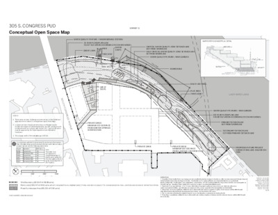
305 S. CONGRESS PUD Conceptual Open Space Map EXHIBIT G WATER QUALITY FEATURE / UNDERGROUND CISTERN 25 YEAR FLOODPLAIN LINE 432.57’ ELEVATION ACCORDING TO COA RAS MODEL GREAT LAWN PIER WATER STEPS TREE 1450 . X A M " 0 - ' 0 7 30'-0" MAX. 40'-0" MAX. CRITICAL WATER QUALITY ZONE SETBACK LINE 100’ FROM SHORELINE HALF CRITICAL WATER QUALITY ZONE SETBACK LINE 50’ FROM SHORELINE WATER QUALITY FEATURE / RAIN GARDEN 35''-0" MAX. TREE 1402 TREES 1396-7 6 75'-0" M A X. 70'-0" X. A M BOARDWALK WATER STEPS CONCEPTUAL DETAIL GREAT STEPS PRIVATE DRIVE: MINIMUM 170' DISTANCE FROM BARTON SPRINGS INTERSECTION S O U T H C O N G R E S S A V E N U E MULTI-USE TRAIL PLAY AREA TREES 1086-7 LADY BIRD LAKE WATER QUALITY FEATURE / RAIN GARDEN 100 YEAR FLOODPLAIN LINE 440.88’ ELEVATION ACCORDING TO COA RAS MODEL PRIMARY SETBACK LINE 150’ FROM SHORELINE SECONDARY SETBACK LINE 50’ FROM PRIMARY SETBACK LINE PRIVATE DRIVE PRIVATE DRIVE: MINIMUM 100' DISTANCE FROM LANEWAY C INTERSECTION PROPOSED FUTURE PROJECT CONNECT RAIL LINE AND/OR STA- TION Park Land (284,447 sf/6.53 acre, which includes the inundated land.) *PARKLAND AREA IS SUBJECT TO CHANGE BASED ON FINAL LOCATION AND DESIGN OF CAPMETRO STATION DEFINITIONS: 1. “Amenitized Water Quality Ponds” are drainage and water quality infrastructure designed to function as a filter for storm water runoff through a layer of natural materials before being discharged to the lake. Functionally used to capture pollutants and characteristically have an aesthetically pleasing configuration of native plants, rock configurations, water features, and other natural qualities that may enhance function, and accompanied by education signage. Amenitized Water Quality Ponds cannot be designed as sedimentation/filtration ponds. 2. “Great Lawn” is an open field lawn, 0.5 to 1.5 acres, which allows for people to gather and observe bats, and which also allows for a variety of recreational activities, open field play and enjoyment of the scenery, respectful of the bat population and their habitat. 3. “Great Steps” are terraced platforms sufficient in size to allow small scale numbers of patrons to gather, sit and observe activity within the park while still accommodating individuals traversing from top to bottom, and must include ADA access. 4. “Pier” is a structure extending into navigable water for use as a landing place or promenade for viewing the lake. 5. “Water Steps” are platforms sufficient in size to allow small scale numbers of patrons to immerse feet into water and observe activity within the park and on the lake. Submitted: July 24, 2019 Updated: June 26, 2020 Updated: October 12, 2020 Updated: April 14, 2021 Updated: July 9, 2021 Updated: December 7, 2021 Updated: January 31, 2022 Updated: April 6, 2022 Updated: June 1, 2022 6 / 8 NOTES: 1. The location and size of all improvements shown on this Exhibit are approximate and subject to change based upon final design. 2. Location and size of improvements shown on the plan may be modified and approved administratively by city staff, so long as such modification is in accordance with Section 3.1.3. Such modification must be approved by the Parks Department and Watershed Protection. 3. The average width of the trail will be up to 15 feet. In conjunction with the Environmental Protection and Restoration Plan, shoreline improvements include the removal of all non-native, invasive species and the following native trees: Tag # Species DBH (in.) 1086 1087 1396 1397 1402 1450 Sycamore American Elm Sycamore American Elm American Elm American Elm 16 10 10 11 8 14 Note: This table does not represent a comprehensive list of trees located within the PUD that will be affected by the redevelopment of the Property. B A RT O N S P RIN G S R O A D S P RIN G S R O A D B A RT O N 0 100’ 200’ 300’ Site Boundary (821,517 sf/18.86 acre) Plaza/Landscape Area (69,233 sf/1.59 acre) CASE NUMBER: C814-89-0003.02 (cid:1007)(cid:1004)(cid:1009)(cid:3)(cid:94)(cid:856)(cid:3)(cid:18)(cid:381)(cid:374)(cid:336)(cid:396)(cid:286)(cid:400)(cid:400)(cid:3)(cid:4)(cid:448)(cid:286)(cid:374)(cid:437)(cid:286)(cid:3) (cid:18)(cid:381)(cid:374)(cid:272)(cid:286)(cid:393)(cid:410)(cid:437)(cid:258)(cid:367)(cid:3)(cid:87)(cid:346)(cid:258)(cid:400)(cid:349)(cid:374)(cid:336)(cid:3)(cid:87)(cid:367)(cid:258)(cid:374) EXHIBIT H S O U T H C O N G R E S S A V E N U E PHASE 1 PHASE 2 LANEWAY B L A N E W A Y A L A N E W A Y C PHASE 3 BARTON SPRINGS ROAD 100’ 200’ 400’