staff report-part 2-item #4-C814-2024-0001 — original pdf
Backup
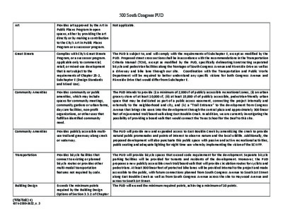
Art Great Streets Community Amenities Provides art approved by the Art in Public Places Program in open spaces, either by providing the art directly or by making a contribution to the City’s Art in Public Places Program or a successor program. Complies with City’s Great Streets Program, or a successor program. Applicable only to commercial, retail, or mixed‐use development that is not subject to the requirements of Chapter 25‐2, Subchapter E (Design Standards and Mixed Use). Provides community or public amenities, which may include spaces for community meetings, community gardens or urban farms, day care facilities, non‐profit organizations, or other uses that fulfill an identified community need. 500 South Congress PUD Not applicable. The PUD is subject to, and will comply with the requirements of Subchapter E, except as modified by the PUD. Proposed street cross sections shall be in accordance with the recommendations in the Transportation Criteria Manual (TCM), except as modified by the PUD, specifically delineating/constructing separated bicycle and pedestrian facilities along the frontages of South Congress Avenue and Riverside Drive as well as a driveway and bike lane through our site. Coordination with the Transportation and Public Works Department will be required to better understand any specific visions for both Congress Avenue and Riverside Drive that would differ from Subchapter E. The PUD intends to provide (i) a minimum of 2,000 sf of publicly accessible recreational zones, (ii) an urban grocery store of at least 10,000 sf, (iii) at least 15,000 sf of publicly accessible, pedestrian‐friendly urban space that may be dedicated as part of a public access easement, connecting the project internally and externally to the neighborhood and city, and (iv) a “Trail Entrance” to the development from Congress Avenue that brings site users into the development through the central plaza and approximately 300 linear feet of rejuvenated trail/boardwalk along East Bouldin Creek. In addition, we are currently investigating the possibility of providing a boardwalk that would connect the Texas School for the Deaf to this site. Community Amenities Provides publicly accessible multi‐ use trail and greenway along creek or waterway. The PUD will provide new and expanded access to East Bouldin Creek by amenitizing the creek to provide natural public promenades and points of interest to observe nature and the local wildlife. Additionally, the proposed development will also punctuate this public space with passive and active recreational activities, public seating and adequate lighting for night time use whereby implementing the vision of the SCWFP. Transportation Building Design {W0670602.4} 4874-2588-3632, v. 3 Provides bicycle facilities that connect to existing or planned bicycle routes or provides other multi‐modal transportation features not required by code. Exceeds the minimum points required by the Building Design Options of Section 3.3.2. of Chapter The PUD will provide bicycle spaces that exceed code requirement for the development. Separate bicycle parking facilities will be provided for tenants and residents of the development. Moreover, the PUD proposes a new publicly accessible creek trail/boardwalk that will provide circulation routes for cyclists and pedestrians. At least 300 linear feet of protected bike lanes will be provided internal to the project and made accessible to the public, with future connections planned from South Congress Avenue to South 1st Street along East Bouldin Creek as well as from South Congress Avenue across the site to Haywood Avenue and across to South 1st Street. The PUD will exceed the minimum required points, achieving a minimum of 10 points. 25‐2, Subchapter E (Design Standards and Mixed Use). In a commercial or mixed‐use development, at least 75 percent of the building frontage of all parking structures is designed for pedestrian‐oriented uses as defined in Section 25‐2‐ 691(C) (Waterfront Overlay District Uses) in ground floor spaces. Provides for affordable housing or participation in programs to achieve affordable housing. Preserves historic structures, landmarks, or other features to a degree exceeding applicable legal requirements. Provides for accessibility for persons with disabilities to a degree exceeding applicable legal requirements. Provides space at affordable rates to one or more independent retail or restaurant small businesses whose principal place of business is within the Austin metropolitan statistical area. Electric Charging Stations 500 South Congress PUD A minimum of 50% of the parking provided onsite will be located below grade. For the remainder of the parking that is above grade a minimum of 75% of the parking structures in the PUD will be designed for pedestrian oriented uses as defined in Section 25‐2‐691(C) (Waterfront Overlay District Uses) in ground floor spaces. Prior to issuance of a final certificate of occupancy for each building, the applicant will be required to pay $9.00 per square foot of bonus area above the baseline FAR of 2:1. The City can use all or a portion of the fee in exchange for onsite affordable units at a rate of $591.00 per square foot. Any such on‐site affordable units will be required to be affordable at 60% MFI for a period of 40 years and in compliance with Chapter 4‐18, Article 2, Density Bonus and Incentive Program requirements. Not applicable. The PUD seeks to create an equitable and inclusive site experience as possible and will provide accessibility for persons with disabilities at a degree that complies with the most stringent legal regulations – be they local, state or federal, both within each of the buildings as well as the overall site and landscape. The PUD will provide 5,000 sf of commercial space for local businesses or non‐profits for lease at an affordable rate for a period of 25 years. Such affordable space shall be available for rent by businesses at no more than eighty percent (80%) of the market rents for similar sized and located commercial space on South Congress Avenue. The PUD will incorporate electric charging stations within the parking garage for use by tenants and visitors of the development. As currently contemplated, the PUD is targeting charging stations for a minimum of 5% of provided parking. Carbon Impact Statement The PUD will participate in the Carbon Impact Statement pilot project and commits to a minimum of 10 points. The sites restored habitat and native plantings will sequester over 5 tons of carbon per year. Parking Structure Frontage Development Bonus Historic Preservation Accessibility Local Small Business Project Specific Superiority Items Project Specific Superiority Items {W0670602.4} 4874-2588-3632, v. 3 500 South Congress PUD Project Specific Superiority Items Project Specific Superiority Items Light Pollution Reduction The PUD will comply with the most current AEGB Light Pollution Reduction criteria available at the time of site plan. Ecology/Bee Habitats The PUD contemplates creating habitat for local bees and other pollinators by using native plants known for attracting pollinators and/or serving as caterpillar host plants. The PUD will include a minimum of 20 native plant species that attract pollinators and/or bird habitat. Project Specific Superiority Items Green Wall Project Specific Superiority Items Additional Community Benefits / Riparian Restoration and Critical Environmental Features (CEFs) The PUD will provide a 500 sf of vertical green wall to reduce the urban heat island effect, increase habitat and overall experience of the site. This will be located within the public realm in an area that receives greater than 4 hours of sunlight and will either be a vine and mesh or living wall system. The PUD commits to making improvements through riparian restoration to both the north and south sides of the creek that will provide a more aesthetic experience for visitors. This includes the expansion of the riparian woodland canopy and enhancement of existing canopy areas to become more biodiverse. In addition, the inclusion of trees of different sizes and age classes will result in more useful habitat. The process of riparian restoration improvement will include: removal of concrete armoring, management of invasive species, installation of bank stabilization where needed and/or laying back of the creek bank, soil enhancement, as well as establishment of a complete riparian community through the planting and seeding of native canopy, understory, and herbaceous layers. The results are better habitat, better places for humans to enjoy nature, and improved water quality. Art in the Public Realm The PUD commits to introducing art into the project’s public realm and shall provide a minimum of $50,000 for public art with the flexibility to provide a rotating exhibit Functional Green Score The PUD will achieve a score of 0.30 under the Draft Functional Green program. SITES Pre‐Certification The PUD will pursue sustainable SITES certification to create a landscape that meets the highest standards in landscape sustainability. LEED Wayfinding/Signage The PUD will commit to achieving a minimum rating of “Silver” for residential buildings and “Gold” for commercial office buildings. The PUD commits to environmental signage and wayfinding that communicates the values of the City of Austin with regard to connection to nature, environmental resilience and sustainability. The PUD will include signage for the following environmental superior elements: Water Quality and Riparian Restoration, Tree Preservation and Relocation, Biofiltration Areas, and Pollinator Planting. Project Specific Superiority Items Project Specific Superiority Items Project Specific Superiority Items Project Specific Superiority Items Project Specific Superiority Items {W0670602.4} 4874-2588-3632, v. 3 EXHIBIT E 500 South Congress PUD Code Modifications General Requirements and Procedures 1. Section 25-1-21(105) (Definitions, Site) is modified to allow a site to cross a public street or right-of-way. 2. Chapter 25-1, Article 14 (Parkland Dedication) is modified such that parkland dedication shall be satisfied in accordance with the standards outlined in the PUD. 3. Section 9-2-21(A)(2) (Permit for Concrete Installation During Non-Peak Hour Periods) is modified to authorize the director to issue a Non-Peak Hour Permit to construct improvements on the Property. Zoning 4. Section 25-2-144(D) (Planned Unit Development (PUD) District Designation) is modified to allow the PUD to include less than 10 acres. 5. Section 25-2, Subchapter B, Article 2, Division 5, Section 2.3.1(L) (Tier One Requirements) is modified to allow the PUD to include less than 10 acres. 6. Section 25-2-491(C) (Permitted, Conditional and Prohibited Uses) is modified to allow the following uses as permitted and conditional uses of the Property. Permitted uses: • Bed & Breakfast (Group 1) • Bed & Breakfast (Group 2) • Condominium Residential • Multifamily Residential • Townhouse Residential • Short-Term Rental (Types 1 and 3) • Administrative and Business Office • Art Gallery • Art Work Shop • Automotive Sales – Max. 8,000 sf interior space. No exterior automotive sales are permitted. • Automotive Rentals • Business or Trade School • Business Support Services • Cocktail Lounge • Commercial Off-Street Parking • Communications Services • Consumer Convenience Services • Consumer Repair Services • Convenience Storage • Electronic Prototype Assembly • Electronic Testing • Financial Services • Food Preparation • Food Sales • General Retail Sales (Convenience) • General Retail Sales (General) • Hotel-Motel • Indoor Entertainment • Indoor Sports and Recreation • Kennels • Laundry Services • Liquor Sales • Medical Offices – exceeding 5,000 sq. ft. gross floor area • Medical Office – not exceeding 5,000 sq. ft. gross floor area • Off-Site Accessory Parking • Outdoor Sports and Recreation • Pedicab Storage and Dispatch • Performance Venue • Personal Improvements Services • Personal Services • Pet Services • Professional Office • Research Assembly Services • Research Services • Restaurant (General) • Restaurant (Limited) • Service Station • Software Development • Theater • Custom Manufacturing • Community Garden • Indoor Crop Production • Urban Farm • Administrative Services • Camp • Club or Lodge • College and University Facilities • Communication Service Facilities • Community Events • Community Recreation (Private) • Community Recreation (Public) • Congregate Living {W1222301.3} 4881-0276-4733, v. 3 • Convalescent Services • Counseling Services • Cultural Services • Day Care Services (Commercial) • Day Care Services (General) • Day Care Services (Limited) • Family Home • Group Home, Class I (General) • Group Home, Class I (Limited) • Group Home, Class II • Hospital Services (General) • Hospital Services (Limited) • Local Utility Services • Maintenance and Service Facilities • Park and Recreation Services (General) • Park and Recreation Services (Special) • Private Primary Educational Facilities • Private Secondary Educational Facilities • Public Primary Educational Facilities • Public Secondary Educational Facilities • Religious Assembly • Safety Services • Telecommunication Tower Conditional uses: • General Warehousing and Distribution • Light Manufacturing • Limited Warehousing and Distribution 7. Section 25-2-691(C) (Waterfront Overlay (WO) District Uses) is modified to allow the following uses as additional pedestrian-oriented uses. Administrative and Business Offices Automotive Sales Automotive Rentals Automotive Repair Services Financial Services Hotel – Motel Medical Offices – exceeding 5,000 sq. ft. gross floor area Medical Office – not exceeding 5,000 sq. ft. gross floor area Performance Venue Personal Improvement Services Personal Services Indoor Entertainment Indoor Sports/Recreation {W1222301.3} 4881-0276-4733, v. 3 Pet Services Professional Office Recreation and Equipment Sales Theater Temporary Uses Described in Section 25-2-921 8. Section 25-2-691(D) (Waterfront Overlay (WO) District Uses) is modified to allow pedestrian oriented uses above the ground floor of a structure. 9. Section 25-2-721(B) (Waterfront Overlay (WO) Combining District Regulations) is modified to allow the following improvements within the primary setback area: Buildings, Sidewalk, Handrails, Pavers, Outdoor Recreation, Boardwalks, Green Infrastructure, Benches, Shade Structures, Site Lighting, Landscaping improvements including - hard surface trails, bicycle trails, picnic facilities, playscapes and rain gardens - underground rain-water cisterns, stormwater outfall structures, concessions, food and beverage vendors, bicycle rentals, sports equipment rentals, dining facilities, performance and special events facilities, boardwalks, sidewalks, pavilions, exercise equipment and courses. 10. Section 25-2-721(B) (Waterfront Overlay (WO) Combining District Regulations) is modified to allow a maximum of 40% percent impervious cover within the primary setback area. 11. Section 25-2-721(G) (Waterfront Overlay (WO) Combining District Regulations) is modified so that loading and unloading shall be allowed from any internal driveway and not required to be screened from public view. Loading and unloading locations on private internal driveways are subject to TCM spacing and dimensional requirements subject to TPW approval. 12. Sections 25-2-742(B)(2) (South Shore Central Subdistrict Regulations) is modified to reduce the primary setback line to 50 feet from the East Bouldin Creek centerline as shown on the Land Use Plan. 13. Development of the property is exempt from Section 25-2-742(C)(2) (South Shore Central Subdistrict Regulations). 14. Section 25-2-742(E)(2) (South Shore Central Subdistrict Regulations) is modified to allow a building base wall with a maximum height of 90 feet south of Riverside Drive. 15. Development of the property is exempt from Section 25-2-742(F) (South Shore Central Subdistrict Regulations). 16. Development of the Property is exempt from the maximum height limitations established in Sections 25-2-742(G)(3) and (G)(4) (South Shore Central Subdistrict Regulations). {W1222301.3} 4881-0276-4733, v. 3 17. Development of the Property is exempt from Chapter 25-2, Subchapter E (Design Standards and Mixed Use), Article 2.2 (Relationship of Buildings and Streets and Walkways), Article 2.3(Connectivity Between Sites), and Article 2.4 (Building Entryways). Site Plan 18. Section 25-5-81(B) (Site Plan Expiration) is modified such that a site plan expires eight (8) years after the date of its approval, unless Section 25-5-81 subsections (C), (D), or (E) are met. Transportation 19. Section 25-6-55 (Dedication of Right-of-Way) is modified to remove the requirement to extend Texas Center Drive through the Property. 20. Section 25-6-381 (Minimum Frontage for Access) is modified to allow access to Congress Avenue and West Riverside Drive which are classified as a major roadway. 21. Section 25-6-477 (Bicycle Parking), 25-6-478 (Motor Vehicle Reductions General), 25-6- 532 (Off-Street Loading Standards), and Appendix A (Tables of Off-Street Loading Requirements and Former Off-Street Parking Requirements) are modified such that the minimum off-street parking, bicycle parking, and loading requirements shall be consistent with market conditions and approved by the TPW Director subject to a TDM Plan approved as part of the PUD. 22. Section 25-6-532 (Off-Street Loading Standards) is modified to allow shared loading and unloading spaces for the various uses within the PUD regardless of where the use or loading and unloading is located within the PUD. Environmental 23. Section 25-8-63(C)(12) (Impervious Cover Calculations) is modified to exclude a parking structure from impervious cover calculations when the parking structure is constructed below the finished grade of the land, is covered by soil having a minimum depth of two feet with an average depth of not less than four feet, and Landowner shall at the time of site plan submit documentation to the City evidencing the discharge or impoundment of groundwater from the parking structure, if any, will be managed to avoid adverse effects on public health and safety, the environment, and adjacent property. A parking structure meeting the requirements of this section may exceed 15% of the site area. 24. Section 25-8-261 (Critical Water Quality Zone Development) and the ECM are modified to allow the following improvement(s) within the Critical Water Quality Zone: Buildings, Sidewalk, Driveways/Drop-Offs, Handrails, Pavers, Outdoor Recreation, Boardwalks, Green Infrastructure, Benches, Shade Structures, Site Lighting, Landscaping improvements including - hard surface trails, bicycle trails, picnic facilities, playscapes {W1222301.3} 4881-0276-4733, v. 3 and rain gardens - underground rain-water cisterns, stormwater outfall structures, concessions, food and beverage vendors, bicycle rentals, sports equipment rentals, dining facilities, performance and special events facilities, boardwalks, sidewalks, pavilions, exercise equipment and courses. 25. Section 25-8-281(C)(1) (Critical Environmental Features) is modified to reduce the critical environmental feature buffer zone from 150-ft to 50-ft. 26. Section 25-8-261(Critical Water Quality Zone Development) is modified to allow impervious cover within the Critical Water Quality Zone to exceed 5% of the total gross area of the Critical Water Quality Zone. Water & Wastewater 27. Section 25-9-412(B) (Reclaimed Water Connection Requirements) is modified such that reclaimed water shall only be used onsite for landscape/irrigation and the at-grade retail. Signage 28. All signage on the Property shall comply with the requirements of Section 25-10-129 (Downtown Sign District Regulations). {W1222301.3} 4881-0276-4733, v. 3 500 SOUTH CONGRESS PUD CODE COMPARISON CHART EXISTING CONDITIONS CURRENT CODE 6.4856 Acres Full Purpose 6.4856 Acres Full Purpose South Central Waterfront Vision Framework Plan 6.4856 Full Purpose 6.4856 Full Purpose 500 SOUTH CONGRESS PUD EXHIBIT F Acreage Jurisdiction Use The property is developed with a four-story office building, a two-story office building, a convenience store, and a multi-family complex with surface parking and related infrastructure. Height The existing buildings on the property range from 2- stories to 4-stories. Setbacks The existing improvements on the property encroach into the primary and secondary setback lines established along Bouldin Creek. The property is zoned CS-1-NP and CS-1-V-NP. A mix of uses are permitted under this existing zoning district and applicable South Shore Central Waterfront Overlay. Assumed property would be developed using PUD zoning. The PUD will consist of a mixed use development with office, hotel, residential, retail, food sales, and food and beverage uses. The PUD proposes a maximum height of 650-ft for a small portion of the site north of the internal drive. The remainder of the site will be limited to a maximum height of 500-ft. The PUD proposes 0-ft setbacks along all property lines. Additionally, the PUD proposes to maintain a 50-ft primary setback parallel to the centerline of East Bouldin Creek and to remove the secondary setback line. 371,000 sq.ft. of Office 32,000 sq.. of Retail 387,000 sq.ft. of Residential 824 above grade structured parking spaces 412 below grade structured Two 200-ft buildings at 15 - 18 stories. The proposed South Central Waterfront Combining District recommends no maximum building height for the property. The SCWFP proposes to consolidate the 80-ft primary and 130-ft secondary waterfront overlay setback established from the centerline of East Bouldin Creek to a 100-ft primary setback. The proposed combining district exempts you from the use and impervious cover limitations within the primary and secondary setback area. Given this proposed change, it appears staff is less concerend with the development that occures within these areas. For the portion of the property zoned CS-1-NP, the property can achieve a maximum height of 60-ft. For the portions of the property zoned CS-1-V-NP, a maximum building height of 90-ft may be achieved in accordance with Section 4.3 of Subchapter E (Vertical Mixed Use Buildings). Section 25-2-742(G)(South Shore Central Subdistrict Regulations) The maximum height is: (1) For structures located between the primary and secondary setback lines, the lower of 35-ft of the maximum height allowed in the base zoning district. (3) For structures located within 100-ft of the right-of-way of South Congress Avenue or South First Street, the lower of 60-ft or the maximum height allowed in the base zoning district. (4) For structures located in all other areas of the subdistrict, the lower of 96-ft or the maximum height allowed in the base zoning district. Section 25-2-642 (Capitol View Corridor (CVC) Overlay District Regulations ) (A) In the Capitol View Corridor (CVC) combining district, the maximum height permitted is the lesser of: (1) the base district maximum height; or (2) The maximum height provided in this section. (B) In a Capitol view corridor, a structure may not exceed the elevation of the plane delineating the corridor. The height limit exceptions in Section 25-2-531 (Height Limit Exceptions) do not apply to this subsection. Section 25-2-492 (Site Development Regulations) Front Yard Setback: 10-ft Street Side Yard: 10-ft Interior Side Yard: 0-ft Rear Yard: 0-ft 25-2-742(South Shore Central Subdistrict Regulations) establish a primary setback line located 80-ft from the centerline of East Bouldin Creek and a secondary setback line 130-ft from the primary setback line parallel to the East Bouldin Creek centerline. Per Section 25-2-721(B) (Waterfront Overlay (WO) Combining District Regulations) in a primary setback area: (1) except as otherwise provided in this subsection, parking areas and structures are prohibited; and (2) Park facilities, including picnic tables, observation decks, trails, gazebos, and pavilions, are permitted if: (a) The park facilities are located on public land; and (b) the impervious cover does not exceed 15% Per Section 25-2-721(C)(South Shore Central Subdistrict Regulations) in a secondary setback area: (1) foundations, patios, terraces, outdoor restaurants, and similar uses are permitted; and (2) impervious cover may not exceed 30%. Section 25-2-742(F)(South Shore Central Subdistrict Regulations) requires a basewall with a maximum height of 35-ft for structures adjacent to and oriented towards Riverside Drive. The portion of the structure building above the basewall and oriented toward Riverside Drive must fit within an envelop delineated by a 70 degree angle starting at a line along the top of the basewall with the base of the angle being the horizontal plan extending from the line parallel to and away from the surface of Riverside Drive. Park Acreage There is no parkland currently on the existing development. The property is located entirely within a Parkland Deficient Area. Section 25-1-601(B) (General Provisions) - Except as otherwise provided in this section the parkland dedication requirements of this article apply to: (1) A residential or commercial subdivision within the planning jurisdiction (2) A site plan within the zoning jurisdiction that includes residential units or commercial square footage; and (3) A building permit for residential or commercial development, as provided under Section 25-1-608 Section 25-2-608(N) (Dedication of Parkland) Development within a PUD zoning district, may, if required by the ordinance adopting the PUD, be subject to additional parkland requirements and may be entitled to count dedicated parkland towards meeting the open space requirements under Chapter 25-2, Article 2, Division 5 (Planned Unit Developments). Identifies areas along East Bouldin Creek within the 100' primary setback and as permanent public access area. The plan further calls for pedestrian access to East Bouldin Creek from the extension of Texas Center Drive within public access easements. The PUD proposes to dedicate parkland area not to exceed 15% of the total land area as shown on the conceptual open space plan submitted with the PUD. This area will include a trail connection to Haywood as well as an east-west trail along the creek. Open Space There is no open space within the existing development. Chapter 25-2, Subchapter E, Section 2.7 (Private Common Open Space and Pedestrian Amenities): all development greater than 2 acres in size and all multi-family and condominium uses shall devote a minimum of 5% of the gross site area to one or more types of private common open space and pedestrian amenities outlined in the section. Water Quality The existing development does not provide any water quality controls. Section 25-8-211 (Water Quality Control Requirement ) - Water quality controls are required for development if the total of new and redeveloped impervious cover exceeds 8,000 square feet. Drainage The property currently drains to East Bouldin Creek. There is no detention currently on the site. Section 25-7-61 (Criteria for Approval of Development Applications) (A) A development application may not be approved unless: (1) the proposed development application demonstrates sufficient capacity for the design flood, as determined by the Drainage Criteria Manual; (2) each proposed improvement is sufficiently strong to resist: (a) external pressure caused by earth or building; and (b) internal pressure or abrasion caused by water or debris; (3) The proposed grades will not permit water to gather in a pool that may become stagnant, excluding variable pools in creek beds as a result of natural channel design; (4) temporary and permanent measures to control erosion are sufficient to minimize siltation of the waterway as determined under the ECM; and (5) The proposed development: (a) will not result in additional adverse flooding impact on other property; (b) to the greatest extent feasible, preserves the natural and traditional character of the land and the waterway located within the 100-year floodplain; (c) except as provided in Subsection B, includes on-site control of the two-year peak flood, as determined under the DCM and ECM. (d) will not result in additional erosion impacts on other property; and (e) locates all proposed improvements outside the erosion hazard zone, unless protective works are provided as prescribed in the ECM. Identifies areas along East Bouldin Creek within the 100' primary setback and as permanent public access area. The plan further calls for pedestrian access to East Bouldin Creek from the extension of Texas Center Drive within public access easements. Green infrastructure such as: permeable pavement, bioswales, raingardens, green roofs, constructed wetlands. The PUD will provide 10% more open space than the 10% and 20% open space requirements for residential and nonresidential programs respectively - as per Tier 2 Superiority. At a minimum, at least 50% of water quality volume will be treated using green water quality controls among those described in the ECM. As currently contemplated, the PUD will utilize rainwater harvesting and a rain garden system to treat approximately 50% of the required water quality volume onsite - first in below grade vaults (using inefficient parts of the parking garage), then pumping this water into raingardens, over the course of a permitted maximum 48 hours, to achieve 100% of the required stormwater treatment using green water quality controls - which will support greater biodiversity and regionally native plants, while reducing stormwater impacts to Bouldin Creek. Green infrastructure such as: permeable pavement, bioswales, raingardens, green roofs, constructed wetlands. We will be meeting code requirements for site detention. Floodplain Portions of the property are located within the City of Austin 25-year and 100-year floodplain. The property is also partially located within the FEMA 100-year floodplain. There are existing improvements/structures located within these areas. Section 25-7-92 (Encroachment on Floodplain Prohibited) (A) Except as provided in Section 25-7-96 (Exceptions in the 25-year floodplain) and unless a variance is granted by the director, a development application may not be approved if a proposed building or parking area encroaches on the 25-year floodplain. (B) Except as provided in Section 25-7-93(General Exceptions), 25-7-94(Exceptions in Central Business Area), and 25-7-95(Exceptions for Parking Areas) and unless a variance is granted by the director, a development application may not be approved if a proposed building or parking area encroaches on the 100-year floodplain. N/A Impervious Cover The property is currently developed with 77.3% impervious cover. Section 25-2-492(Site Development Regulations) limits impervious cover for property zoned CS- 1 to 95%. N/A Instead of showing the existing floodplain per GIS, the floodplain delineation has been updated based on the City models and more detailed topographic information for the site. The PUD proposes to remove 8,000 square feet of concrete embankment and 8,890 square feet of impervious cover within the East Bouldin Creek Floodplain for a total of 16,890 square feet. The PUD proposes a maximum impervious cover of 90% which is a 5% reduction of the maximum impervious cover allowed under existing zoning. CWQZ The property includes approximately 2.25 acres within the Critical Water Quality Zone (CWQZ) at 75% impervious cover. There are several improvements including building structures and surface parking within this area. Section 25-8-261 (Critical Water Quality Zone Development) - Development is prohibited in a Critical Water Quality Zone with the exception of passive improvements such as fences, open space, athletic fields, etc.. Development allowed within the Critical Water Quality Zone under this Division shall be revegetated and restored within the limits of construction as prescribed by the ECM. Compliance with current code. Proposed trails along East Bouldin Creek shall be located a least 50-ft from the centerline of the creek. As currently contemplated, the PUD proposes a 7,658 SF reduction of impervious cover in the CWQZ, which includes the existing buildings and accessory surface parking lots. The PUD proposes removing over 8,000 square feet of concrete embankment adjacent to Bouldin Creek as well as 8,890 square feet of additional impervious cover from the floodplain. N/A Critical Environmental Features (CEF) N/A CWQZ crossing Cut/Fill Construction on Slopes Tree Protection N/A N/A N/A N/A N/A N/A N/A Section 25-8-602(Definitions) (1) Heritage Tree means a tree that haws a diameter of 24 inches or more, measured four and a half feet above natural grade, and is one of the following species: Texas Ash, Bald Cypress, American Elm, Cedar Elm, Texas Madrone, Bigtooth Maple, All Oaks, Pecan, Arizona Walnut, Eastern Black Walnut. (2) Protected tree means a tree with a diameter of 19-inches or more, measured four and a half feet above natural grade. Section 25-8-621 (Permit Required for Removal of Protected Trees; Exceptions). (A) Except as otherwise provided in this section, a person may not remove a protected tree unless the Planning and Development Review Department has issued a permit for removal under this Division. Section 25-8-641 (Removal) (A) Removal of a heritage tree is prohibited unless the Planning and Development Review Department has issued a permit for the removal under this Division. (B) A permit to remove a heritage tree may be issued only if a variance is approved under Section 25-8-642(Administrative Variance) or 25-8-643(Land Use Commission Variance). Green Building N/A The property is not required to comply with the City of Austin's Green Building Program under Current Code. N/A N/A N/A N/A Tree Protection: -100% of heritage trees shall be preserved, unless a tree is dead, diseased, or an imminent hazard. Protected trees shall be preserved. Street Trees: - At least 1,000 cubic fee of soil volume shall be provided per tree. Alternatively, the City Arborist may allow alternative compliance if there is a utility conflict or 1,000 cubic fee is otherwise not available. - Overhead utilities shall be relocated underground to avoid any conflicts with the planting of shade trees. - all new utilities shall be located under the street with sufficient clearances to allow for the tree planting zone. Lateral lines may cross the planting zone. -Exhibit overhead utilities shall be relocated underground. -Root barriers shall be introduced and located solely on the utility sid, rather than creating boxes around the trees. 2-Star AEGB rating. N/A While our site does not contain any Critical Environmental Features (CEFs), it is impacted by a CEF located on the south side of the creek that the Project is currently evaluating/surveying. The PUD requests to reduce the CEF setback buffer from 150' to 50' as recommended per the ERI. N/A N/A 100% of all Heritage trees that are not dead, diseased or an imminent danger to people or property will be preserved. The PUD will achieve a minimum 2 star rating under the City of Austin's Green Building Program. The PUD will also achieve a minimum rating of Silver for resdiential buildings and Gold for commercial office buildings under the LEED program. CS-1-V-NP CS-1-V-NP CS-1-V-NP I N O S V E R I EXHIBIT G 2 9 5 2 - 8 9 2 ) 2 1 5 ( x a F 4 8 2 3 - 8 9 2 ) 2 1 5 ( . l e T 5 2 0 2 t h g i r y p o C © C L L , C M E a z r a G 9 2 6 4 1 - F # E P B T 5 3 7 8 7 s a x e T , n i t s u A 5 2 1 e t i u S l , . d v B o t l a R 8 0 7 7 i CS-1-V-NP P-NP CS-1-V-NP E V D A O O W Y A H RIV E R SID E D R CS-1-V-NP CS-1-V-NP CS-1-V-NP P-NP TOTAL SITE AREA: 6.48 ACRES CS-1-V-NP CS-1-NP CS-1-V-NP CS-1-V-NP UNZ E V A S S E R G N O C CS-1-V-NP CS-1-V-NP . O N E T A D SITE BOUNDARY ADJACENT TRACT LINE CRITICAL WATER QUALITY ZONE CRITICAL WATER QUALITY ZONE HATCH EAST BOULDIN CREEK CENTERLINE WATERFRONT OVERLAY PRIMARY SETBACK WATERFRONT OVERLAY SECONDARY SETBACK PER SOUTH SHORE CENTRAL DISTRICT EXISTING HEC-RAS CORRECTED EFFECTIVE 100 YR FLOODPLAIN BOUNDARY EXISTING HEC-RAS CORRECTED EFFECTIVE 100 YR FLOODPLAIN BOUNDARY HATCH EXISTING 150' RIM ROCK BUFFER EXISTING 150' RIM ROCK BUFFER HATCH I G N N O Z G N T S X E I I X T , D U P S S E R G N O C . S 0 0 5 I N T S U A S S E R G N O C . S 0 0 5 I S E N A P M O C D E T A L E R E H T M P 3 4 1 5 2 : , 2 1 r a M l n o y e g n a m y b d e l 5 0 0 0 0 - 0 7 8 3 1 1 : . O N T C E J O R P : Y B D E N G S E D I : Y B N W A R D : C Q / A Q SHEET 01 05 OF i f i . d o m g w d E N O Z - 5 0 0 0 0 - 0 7 8 3 1 1 \ S T B H X E D U P S T B H X E D A C - 0 0 \ l i \ I I I \ I i v C \ 5 0 0 0 0 - 0 7 8 3 1 1 \ : V RIV E R SID E D R EXHIBIT H 2 9 5 2 - 8 9 2 ) 2 1 5 ( x a F 4 8 2 3 - 8 9 2 ) 2 1 5 ( . l e T 5 2 0 2 t h g i r y p o C © C L L , C M E a z r a G 9 2 6 4 1 - F # E P B T 5 3 7 8 7 s a x e T , n i t s u A 5 2 1 e t i u S l , . d v B o t l a R 8 0 7 7 i E V D A O O W Y A H CS-1-V-NP CS-1-NP TOTAL SITE AREA: 6.48 AC E V A S S E R G N O C CS-1-V-NP CS-1-V-NP CRITICAL WATER QUALITY ZONE CRITICAL WATER QUALITY ZONE HATCH EAST BOULDIN CREEK CENTERLINE PROPERTY LINE 100' SETBACK FROM SOUTH CONGRESS ROW WATERFRONT OVERLAY SECONDARY SETBACK PER SOUTH SHORE CENTRAL DISTRICT WATERFRONT OVERLAY PRIMARY SETBACK EXISTING HEC-RAS CORRECTED EFFECTIVE 100 YR FLOODPLAIN BOUNDARY EXISTING HEC-RAS CORRECTED EFFECTIVE 100 YR FLOODPLAIN BOUNDARY HATCH EXISTING 150' RIM ROCK BUFFER EXISTING 150' RIM ROCK BUFFER HATCH I I S N O T D N O C G N T S X E I I X T D U P S S E R G N O C . S 0 0 5 , I N T S U A S S E R G N O C . S 0 0 5 I S E N A P M O C D E T A L E R E H T M P 2 5 : 1 5 2 , 2 1 r a M l n o y e g n a m y b d e l i f i . - - d o m g w d D N O C H X E D U P - 5 0 0 0 0 - 0 7 8 3 1 1 x \ S T B H X E D U P S T B H X E D A C - 0 0 \ l i \ I \ I I I i v C \ 5 0 0 0 0 - 0 7 8 3 1 1 \ : V 5 0 0 0 0 - 0 7 8 3 1 1 : . O N T C E J O R P : Y B D E N G S E D I : Y B N W A R D : C Q / A Q SHEET 02 05 OF RIV E R SID E D R E V D A O O W Y A H HEIGHT AREA 1: MAX. HEIGHT 650' MIXED USE TOTAL SITE AREA: 6.48 AC HEIGHT AREA 2: MAX. HEIGHT 500' EXHIBIT I 2 9 5 2 - 8 9 2 ) 2 1 5 ( x a F 4 8 2 3 - 8 9 2 ) 2 1 5 ( . l e T 5 2 0 2 t h g i r y p o C © C L L , C M E a z r a G 9 2 6 4 1 - F # E P B T 5 3 7 8 7 s a x e T , n i t s u A 5 2 1 e t i u S l , . d v B o t l a R 8 0 7 7 i E V A S S E R G N O C CRITICAL WATER QUALITY ZONE CRITICAL WATER QUALITY ZONE HATCH EAST BOULDIN CREEK CENTERLINE PROPERTY LINE 50' PRIMARY CREEK SETBACK EXISTING HEC-RAS CORRECTED EFFECTIVE 100 YR FLOODPLAIN BOUNDARY EXISTING HEC-RAS CORRECTED EFFECTIVE 100 YR FLOODPLAIN BOUNDARY HATCH SITE BOUNDARY PROPOSED 50' RIM ROCK BUFFER PROPOSED 50' RIM ROCK BUFFER HATCH HEIGHT AREA 1 (MAX 650') HEIGHT AREA 2 (MAX 500') N A L P E S U D N A L D E S O P O R P X T D U P S S E R G N O C . S 0 0 5 , I N T S U A S S E R G N O C . S 0 0 5 I S E N A P M O C D E T A L E R E H T M P 2 4 1 5 2 : , 2 1 r a M l n o y e g n a m y b d e l i f i . - d o m g w d E S U D N A L - 5 0 0 0 0 - 0 7 8 3 1 1 \ S T B H X E D U P S T B H X E D A C - 0 0 \ l i \ I \ I I I i v C \ 5 0 0 0 0 - 0 7 8 3 1 1 \ : V 5 0 0 0 0 - 0 7 8 3 1 1 : . O N T C E J O R P : Y B D E N G S E D I : Y B N W A R D : C Q / A Q SHEET 03 05 OF LAND USES AND INTENSITIES NOTED ABOVE ARE SUBJECT TO CHANGE. SUCH CHANGES SHALL BE PROCESSED ADMINISTRATIVELY AS LONG AS THE NUMBER OF TRIPS SHOWN IN THE TIA DATED 08/13/2024 AND ANY SUBSEQUENT AMENDMENTS TO THE TIA ARE NOT EXCEEDED. • • • • • • • • • • • • • • • • • • • • • • • • • • • • • • • • • • • • • • • • • • • • • • • • • • • • • • • • • • • • • • • • • • • • • • • • • • • • • • • • • • • • • • • • • • • • • • • • • • • • • • • • – – – – – – – EXHIBIT J 2 9 5 2 - 8 9 2 ) 2 1 5 ( x a F 4 8 2 3 - 8 9 2 ) 2 1 5 ( . l e T 5 2 0 2 t h g i r y p o C © C L L , C M E a z r a G 9 2 6 4 1 - F # E P B T 5 3 7 8 7 s a x e T , n i t s u A 5 2 1 e t i u S l , . d v B o t l a R 8 0 7 7 i – ’ S E T O N L A R E N E G X T D U P S S E R G N O C . S 0 0 5 , I N T S U A S S E R G N O C . S 0 0 5 I S E N A P M O C D E T A L E R E H T M P 7 4 5 5 2 : , 9 r p A l n o y e g n a m y b d e l i f i . - d o m g w d S E T O N H X E - 5 0 0 0 0 - 0 7 8 3 1 1 \ S T B H X E D U P S T B H X E D A C - 0 0 \ l i \ I I \ I I i v C \ 5 0 0 0 0 - 0 7 8 3 1 1 \ : V 5 0 0 0 0 - 0 7 8 3 1 1 : . O N T C E J O R P : Y B D E N G S E D I : Y B N W A R D : C Q / A Q SHEET 04 05 OF POINT OF ACCESS RIV E R SID E D R E V D A O O W Y A H POINT OF ACCESS ONE-WAY DRIVEWAY POINT OF ACCESS POINT OF ACCESS TOTAL SITE AREA: 6.48 ACRES E V A S S E R G N O C PROPOSED INTERNAL DRIVEWAY (ONE WAY) POINT OF ACCESS PEDESTRIAN SIDEWALK PROPOSED 50' PRIMARY SETBACK POINT OF ACCESS HEC-RAS 100 YR FLOODPLAIN APPROXIMATE CREEK CENTERLINE STORM WATER DRAINAGEWAY EASEMENT VOL. 4005, PG. 1155 PROPOSED 50' RIM ROCK BUFFER APPROX. LOCATION EXISTING RIM ROCK (CRITICAL ENVIRONMENTAL FEATURE) EXHIBIT K 2 9 5 2 - 8 9 2 ) 2 1 5 ( x a F 4 8 2 3 - 8 9 2 ) 2 1 5 ( . l e T 5 2 0 2 t h g i r y p o C © C L L , C M E a z r a G 9 2 6 4 1 - F # E P B T 5 3 7 8 7 s a x e T , n i t s u A 5 2 1 e t i u S l , . d v B o t l a R 8 0 7 7 i I N O S V E R I . O N E T A D SITE BOUNDARY ADJACENT TRACT LINE PEDESTRIAN TRAIL/BOARDWALK ROUTE CRITICAL WATER QUALITY ZONE CRITICAL WATER QUALITY ZONE HATCH EAST BOULDIN CREEK CENTERLINE 50' PRIMARY CREEK SETBACK EXISTING HEC-RAS CORRECTED EFFECTIVE 100 YR FLOODPLAIN BOUNDARY EXISTING HEC-RAS CORRECTED EFFECTIVE 100 YR FLOODPLAIN BOUNDARY HATCH PROPOSED 50' RIM ROCK BUFFER PROPOSED 50' RIM ROCK BUFFER HATCH I I T B H X E S S E C C A * ** LOCATION AND CONFIGURATION OF ACCESS POINTS WILL BE BASED UPON FINAL DESIGN LOCATION AND CONFIGURATION OF TRAIL AND BOARDWALK IS APPROXIMATE AND SUBJECT TO CHANGE BASED UPON FINAL DESIGN *** THIS PUD WILL PROHIBIT GATED ROADWAYS X T , LAND USES AND INTENSITIES NOTED ABOVE ARE SUBJECT TO CHANGE. SUCH CHANGES SHALL BE PROCESSED ADMINISTRATIVELY AS LONG AS THE NUMBER OF TRIPS SHOWN IN THE TIA DATED 08/13/2024 AND ANY SUBSEQUENT AMENDMENTS TO THE TIA ARE NOT EXCEEDED. D U P S S E R G N O C . S 0 0 5 I N T S U A S S E R G N O C . S 0 0 5 I S E N A P M O C D E T A L E R E H T M P 7 4 : 5 5 2 , 9 r p A l n o y e g n a m y b d e l i f i I I . d o m g w d T B H X E S S E C C A 5 0 0 0 0 - 0 7 8 3 1 1 : . O N T C E J O R P : Y B D E N G S E D I : Y B N W A R D : C Q / A Q SHEET 05 OF 05 - I I P H X E - 5 0 0 0 0 - 0 7 8 3 1 1 \ S T B H X E D U P S T B H X E D A C - 0 0 \ l i \ I I \ i v C \ 5 0 0 0 0 - 0 7 8 3 1 1 \ : V EXHIBIT L landscape architects, planners & designers 3232 e cesar chavez st bldg 1, suite 100 austin, tx 78702 [512] 327-1011 project 500 S. Congress PUD related co. austin, tx project number a23034 issue date 04/07/25 designed: drawn: reviewed: sheet title conceptual open space plan sheet L.04 CONCEPTUAL OPEN SPACE AND PARKLAND DEDICATION PLAN 1 0' 15' 30' 60' SCALE: 1"=30' N O R T H EXHIBIT M Notes: 1. There are no trails and/or impervious cover within 50’ of the critical environmental feature on the adjacent state-owned land. 2. The Rimrock feature is upstream of the site and will not be impacted by any activities at 500 S. Congress. 3. Not more than 2,000 sqft of trail and/or imprevious cover are planned within 150’ of critical environmental feature on adjacent state-owned property. 4. Mitigation is not being considered for necessary creek armoring. Mitigation Table Area of CEF Buffer Trail Impact: .0459 AC (2,000 sq ft) Area of Riparian Restoration Mitigation: .0459 AC (2,000 sq ft) Seeds used in Mitigation*: 1.5 lbs * Seeding Rate based on (609s.5 Table 6 @ 27 lbs/arce+20%) * Delineation of the proposed floodplain/CWQZ is subject to change based on final design and will be confirmed during the site plan process. 500 S. CONGRESS PUD Critical Environmental Feature Mitigation hayw ood hayw ood r r i i v v e e r r S S i i d d e e d d r r i i v v e e DEVELOPED 100 YEAR FLOODPLAIN/CWQZ S S S S e e r r g g n n o o C C h h t t u u o o S S 50’ PRIMARY SETBACK Riparian Restoration CEF Mitigation Subject to change based on final design Proposed 50’ Primary Setback Proposed 50’ Critical Environmental Feature Setback Code Required 150’ Critical Environmental Feature Setback Riparian Restoration CEF Mitigation Conceptual Bank armoring East Bouldin Creek Site Boundary 0 100 ft CODE REQUIRED 150’ CRITICAL ENVIRONMENTAL FEATURE SETBACK PROPOSED 50’ CRITICAL ENVIRONMENTAL FEATURE SETBACK e e a a s s t t b b o o u u l l d d i i n n c c r r e e e e k k CRITICAL ENVIRONMENTAL FEATURE ENVIRONMENTAL SUPERIORITY ELEMENTS Developed 100 year floodplain/CWQZ Floodplain restoration planting Pollinator bed plantings or rain gardens Trail within 150’ CEF buffer 500 S. CongressPrepared by Siglo Group I N O S V E R I . O N E T A D WATERFRONT PRIMARY SETBACK BARTON SPRING ROAD-CONGRESS AVENUE CONNECTOR FEMA FLOODPLAIN CRITICAL WATER QUALITY ZONE COA 100 YR EAST BOULDIN CREEK CENTERLINE PROPERTY LINE 100' SETBACK FROM SOUTH CONGRESS ROW COA 100 YR HATCH CRITICAL WATER QUALITY ZONE HATCH PERVIOUS COVER CS-1-V-NP CS-1-NP SITE AREA: 6.01 AC CS-1-V-NP EXISTING CWQZ IMPERVIOUS COVER CALCS: ML 2024-10-07 CWQZ TOTAL AREA = 36,662 SF (0.8416 AC) PERVIOUS COVER = 18,982 SF (0.4358 AC) IMPERVIOUS COVER = 17,680 (0.4058 AC) IMPERVIOUS COVER % = 48.2% EXHIBIT M 2 9 5 2 - 8 9 2 ) 2 1 5 ( x a F 4 8 2 3 - 8 9 2 ) 2 1 5 ( . l e T 4 2 0 2 t h g i r y p o C © C L L , C M E a z r a G 9 2 6 4 1 - F # E P B T 5 3 7 8 7 s a x e T , n i t s u A 5 2 1 e t i u S l , . d v B o t l a R 8 0 7 7 i / I N A L P D O O L F Z Q W C G N T S X E I I I S E N A P M O C D E T A L E R E H T I I N H T W R E V O C S U O V R E P M I I X T , S S E R G N O C . S 0 0 5 I N T S U A S S E R G N O C . S 0 0 5 5 0 0 0 0 - 0 7 8 3 1 1 : . O N T C E J O R P : Y B D E N G S E D I : Y B N W A R D : C Q / A Q SHEET EXH OF M P 0 3 : 4 4 2 , 7 t c O n o l l y e g n a m y b d e i f i d o m g w d p m . i - x e - z q w c - 5 0 0 0 0 - 0 7 8 3 1 1 x _ 7 0 - 0 1 - 4 2 0 2 R E V O C S U O V R E P M I \ I \ I I S T B H X E D A C - 0 0 \ l i \ i v C \ 5 0 0 0 0 - 0 7 8 3 1 1 \ : V RIV E R SID E D R E V D A O O W Y A H E V A S S E R G N O C PHASE 1 TOTAL SITE AREA: 6.48 ACRES SITE/PHASING BOUNDARY CRITICAL WATER QUALITY ZONE CRITICAL WATER QUALITY ZONE HATCH EAST BOULDIN CREEK CENTERLINE 50' PRIMARY CREEK SETBACK EXISTING HEC-RAS CORRECTED EFFECTIVE 100 YR FLOODPLAIN BOUNDARY EXISTING HEC-RAS CORRECTED EFFECTIVE 100 YR FLOODPLAIN BOUNDARY HATCH SITE BOUNDARY PROPOSED 50' RIM ROCK BUFFER PROPOSED 50' RIM ROCK BUFFER HATCH IC WITHIN THE PROPOSED FLOODPLAIN/CWQZ (BASED ON LAKEFLATO SITE PLAN AND CROSS SECTIONS) PROPOSED IMPERVIOUS COVER IN PROPOSED CWQZ (BASED ON LAKE FLATO CROSS SECTIONS) PROPOSED CWQZ AREA: 1.1122 AC. (48,448 SF) TRAIL/SIDEWALK 0.0859 AC. (3,740 SF) FLATWORK BLDG. 0.0998 AC. (4,348 SF) 0.0444 AC. (1,934 SF) PROPOSED TOTAL IC: 0.2301 AC. (10,022 SF) PROPOSED IC %: 20.7% EXHIBIT N 2 9 5 2 - 8 9 2 ) 2 1 5 ( x a F 4 8 2 3 - 8 9 2 ) 2 1 5 ( . l e T 4 2 0 2 t h g i r y p o C © C L L , C M E a z r a G 9 2 6 4 1 - F # E P B T 5 3 7 8 7 s a x e T , n i t s u A 5 2 1 e t i u S l , . d v B o t l a R 8 0 7 7 i Z Q W C - R E V O C I S E N A P M O C D E T A L E R E H T M P 6 5 3 : 4 2 , 7 t c O n o l y e g n a m y b l I N O S V E R I . O N E T A D I S U O V R E P M I D E S O P O R P X T , D U P S S E R G N O C . S 0 0 5 I N T S U A S S E R G N O C . S 0 0 5 5 0 0 0 0 - 0 7 8 3 1 1 : . O N T C E J O R P : Y B D E N G S E D I : Y B N W A R D : C Q / A Q SHEET EXH OF d e i f i d o m g w d C . I \ Z Q W C d e s o p o r P Z Q W C S T B H X E D A C - 0 0 \ l i I I \ \ i v C \ 5 0 0 0 0 - 0 7 8 3 1 1 \ : V 500 S. CONGRESS PUD Environmental Superiority Plan hayw ood hayw ood r r i i v v e e r r S S i i d d e e d d r r i i v v e e DEVELOPED 100 YEAR FLOODPLAIN/CWQZ S S S S e e r r g g n n o o C C h h t t u u o o S S 50’ PRIMARY SETBACK e e a a s s t t b b o o u u l l d d i i n n c c r r e e e e k k PROPOSED 50’ CEF SETBACK ENVIRONMENTAL SUPERIORITY ELEMENTS Developed 100 year floodplain/CWQZ Floodplain restoration planting Pollinator bed plantings or rain gardens Proposed 50’ primary Setback Proposed 50’ CEF Setback Subject to change based on final design Conceptual Bank armoring East Bouldin Creek Site Boundary 0 100 ft EXHIBIT O Notes: 1. 2. Increased Floodplain Volume: 100-year floodplain volume will increase by 25,000 cu ft on the site. Increased Floodplain Functionality: All floodplain habitat areas will move from “poor” or “fair” to at least “good” condition based on the functional floodplain assessment as described in Appendix X of the City of Austin Environmental Criteria Manual. 3. Armoring and Impervious Cover Reductions in the Floodplain: Bank armoring will be reduced to only areas critical for urban creek stability resulting in the removal of 8,000 square feet of concrete embankment and 8,890 square feet of parking lot within East Bouldin Creek Floodplain. 4. Increased Creek Habitat: Over 23,000 sq ft will be restored riparian habitat in the 100-year floodplain. Restoration will include invasive species removal, soil decompaction and enhancement, planting, and seeding. 5. Native Pollinator Plants: The PUD will include at least 20 native plant species that attract pollinators. 6. SITES Certification: The PUD will pursue Sustainable SITES certification to create a landscape that meets the highest standards in landscape sustainability. 7. Superior Plant Diversity and Stability: The proposed plan will include at least 20 species native to the Edwards Plateau and Blackland Prairie, which are important throughout the lifespan of pollinators. The PUD will take advantage of the canyon-like setting within this urban development and utilize the unique species of the Edwards Plateau and Blackland Prairie to create landscapes that are both ecologically appropriate and aesthetically appealing. Over 50 species will be included in the final planting plan provided as part of the site plan and 70% of all plantings on site will be from the Edwards Plateau and Blackland Prairie. All riparian restoration plantings will exceed density and diversity code requirements by at least 20%, based on COA ECM 609s criteria. Additionally, 30% of the plant species along the wetland fringe of East Bouldin Creek will have a stability rating of 6 or greater. 8. Carbon Sequestration: The sites restored habitat and native plantings will sequester over 5 tons of carbon per year. 9. Human/ Nature Connection: The PUD will engage visitors with shaded open space that allows for appreciation and engagement with the restored riparian areas and compelling landscapes throughout the site that showcase native flora and fulfill the aspirations of the South Central Waterfront Plan. 10. Natural Areas Management Plan: A natural areas management plan will be prepared and provided at time of site plan. The plan will use an adaptive management framework with a focus on an enhanced user experience, ecological functionality, creek health, water quality, integrated pest management, invasive species management, increases in diversity through planting and seeding, ensuring natural vegetative cover, and annual monitoring. * Delineation of the proposed floodplain/CWQZ is subject to change based on final design and will be confirmed during the site plan process. 500 S. Congress Environmental SuperiorityPrepared by Siglo Group EXHIBIT P January 30, 2025 Revised March 7, 2025 Zach Kretsch, P.E., CFM City of Austin, Watershed Protection Department PO Box 1088 Austin, TX 78767 RE: 500 South Congress PUD (C814-2024-0001) Floodplain Modeling Mr. Kretsch, For the 500 South Congress PUD (C814-2024-0001), GarzaEMC was requested to review the Effective floodplain model and prepare a Corrected Effective model for East Bouldin Creek in the vicinity of the subject site to reflect current existing topographic conditions and City of Austin (COA) Atlas 14 flows. A copy of the FEMA/COA Effective hydraulic model was obtained by GarzaEMC via the COA FloodPro online tool. The Effective model for “East Bouldin Creek” was completed in United States Army Corps of Engineers (USACE) Hydrologic Engineering Center’s River Analysis Software (HEC-RAS) version 4.1.0 in 2005 by Halff Associates, Inc. as part of a Travis County Flood Insurance Restudy and later updated by Halff Associates per the “Park at East Bouldin Letter of Map Revision (18-06-2729P).” This hydraulic model (one-dimensional, steady flow) was opened and run in HEC-RAS 4.1.0 to confirm Effective model results and create a Duplicate Effective model. A topographic survey of the subject property was completed by Stantec, Inc. in October 2023. This topographic survey data and TIN surface were provided to GarzaEMC on behalf of the client. GarzaEMC created a combined existing conditions surface using Autodesk Civil3D software by merging the Stantec site survey with current City of Austin GIS contours (to include topographic data beyond the site survey limits). Effective cross-section geometry was imported into Civil3D, which was then used to extract station-elevation data from the existing conditions topographic surface for each of the impacted cross sections along the subject property. A Corrected Effective model was then created in HEC-RAS 4.1.0 by inserting the survey station-elevation data for the portion(s) of each Effective cross section overlapping the surveyed site area. Two (2) new cross sections were also added to the Corrected Effective model at river stations 3101 and 2802, and obstructions were added/edited for the affected cross sections to reflect existing structures on the subject property. In addition to these geometry updates, the Effective hydrologic model downloaded from COA FloodPro was updated using Hydrologic Engineering Center’s Hydrologic Modeling Software (HEC-HMS) version 4.8 to reflect City of Austin Atlas 14 rainfall data. The resulting flows from the Atlas 14 updated HMS model were applied to the Corrected Effective RAS model steady flow data. GarzaEMC | 7708 Rialto Blvd., Suite 125 | Austin, TX 78735 | 512.298.3284 www.garzaemc.com | TBPE No. F-14629 Page 2 Following these edits, the one-dimensional, steady flow hydraulic analysis was recomputed in HEC-RAS to create the Corrected Effective RAS model. Table 1 summarizes the COA Atlas 14 flows from the revised HEC-HMS model, which were then used to update the Steady Flow data in the Corrected Effective HEC-RAS model. Table 1: Corrected Effective HMS Model Summary HMS Junc(cid:72)on Reach RAS River Sta(cid:72)on JEBLDNO90a JEBLDNO100a 3 3 4415 2247 Effec(cid:72)ve FEMA 100-year flows (pre-Atlas 14) 4280 4520 Effec(cid:72)ve FEMA 500-year flows (pre-Atlas 14) 5200 5390 Corrected Effec(cid:72)ve 100-year flows (Atlas 14) 4856.4 5092.3 Table 2 summarizes the HEC-RAS Corrected Effective model, including cross sections that were revised or added per new survey/GIS station-elevation data and the resulting Water Surface Elevations (WSELs). Table 2: Corrected Effective RAS Model Summary XS River Sta(cid:72)on XS updated with new topo? (Y/N) 3631 3454 3231 3101* 2977 2882* 2773 2707 2629 2447 2362 N N Y Y* Y Y* Y Y N N N Effec(cid:72)ve WSEL ((cid:77)) 450.66 450.63 450.61 N/A 450.52 N/A 450.50 450.50 450.30 447.05 446.88 *New cross-section added for Corrected Effective model. Corrected Effec(cid:72)ve WSEL ((cid:77)) 451.15 451.11 451.06 451.04 450.95 450.95 450.95 450.95 450.76 447.24 447.07 Corrected Effec(cid:11)ve vs. Effec(cid:11)ve Δ WSEL ((cid:77)) 0.49 0.48 0.45 N/A 0.43 N/A 0.45 0.45 0.46 0.19 0.19 For delineation of the resulting floodplain, ArcMap 10.8.1 and SAGA-GIS software were used to generate a terrain file from the combined existing conditions surface previously described above. The RASMapper tool in HEC-RAS 4.1.0 was then used to delineate the floodplain boundaries with terrain. The resulting Atlas-14 100-year floodplain boundary is shown on the attached “Corrected Effective Floodplain” exhibit. Page 3 The following certification statements are provided in conjunction with the floodplain modeling and delineation summarized above and per the provided attachments: - - I, Nathan Presmyk, P.E., confirm that the best available data was used to delineate the City of Austin floodplain per Drainage Criteria Manual (DCM) Section 1.2.6. I, Nathan Presmyk, P.E., certify the accuracy of the provided HEC-HMS and HEC-RAS models for the subject site. Sincerely, Nathan Presmyk, P.E. Sr. Project Manager Attachments: 1. 2. 3. 4. Revised Atlas 14 “East Bouldin Creek” HEC-HMS model Duplicate Effective “East Bouldin Creek” HEC-RAS model Corrected Effective “East Bouldin Creek” HEC-RAS model “Corrected Effective Floodplain” Exhibit V:\113870-00005\Civil\01-Word Docs\Letters\20250307_floodplain_memo.docx 8/19/2219/22/203/07/25