item #4-staff report-C814-06-0109.03 — original pdf
Backup
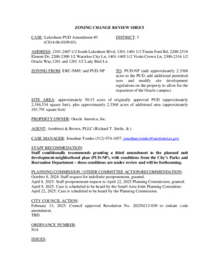
ZONING CHANGE REVIEW SHEET CASE: Lakeshore PUD Amendment #3 DISTRICT: 3 (C814-06-0109.03) ADDRESS: 2101-2407 1/2 South Lakeshore Blvd; 1201-1401 1/2 Tinnin Ford Rd; 2200-2518 Elmont Dr; 2200-2300 1/2 Waterloo City Ln; 1401-1405 1/2 Violet Crown Ln; 2300-2316 1/2 Oracle Way,1201 and 1201 1/2 Lady Bird Ln ZONING FROM: ERC-NMU and PUD-NP TO: PUD-NP (add approximately 2.3368 acres to the PUD, add additional permitted site development uses regulations on the property to allow for the expansion of the Oracle campus). and modify SITE AREA: approximately 50.15 acres of originally approved PUD (approximately 2,184,534 square feet), plus approximately 2.3368 acres of additional area (approximately 101,791 square feet) PROPERTY OWNER: Oracle America, Inc. AGENT: Armbrust & Brown, PLLC (Richard T. Suttle, Jr.) CASE MANAGER: Jonathan Tomko (512) 974-1057, jonathan.tomko@austintexas.gov STAFF RECOMMEDATION: Staff conditionally recommends granting a third amendment to the planned unit development-neighborhood plan (PUD-NP), with conditions from the City’s Parks and Recreation Department – these conditions are under review and will be forthcoming. PLANNING COMMISSION / OTHER COMMITTEE ACTION/RECOMMENDATION: October 8, 2024: Staff request for indefinite postponement, granted. April 8, 2025: Staff postponement request to April 22, 2025 Planning Commission, granted. April 9, 2025: Case is scheduled to be heard by the Small Area Joint Planning Committee. April 22, 2025: Case is scheduled to be heard by the Planning Commission. CITY COUNCIL ACTION: February 13, 2025: Council approved Resolution No. 20250213-030 to initiate code amendment. TBD ORDINANCE NUMBER: N/A ISSUES: C814-06-0109.03 2 The subject tract is within the Waterfront Overlay and is subject to § 25-2-741, the South Lakeshore Subdistrict Regulations which states that there are setback lines located within 65 feet of the Town Lake shoreline and 50 feet south of the Lakeshore Boulevard. There is also a maximum height, the lower of 60 feet or the maximum height allowed in the base zoning district. The applicant is seeking Section 25-2-741(C) (South Lakeshore Subdistrict Regulations) to modify the maximum height to 120 feet in the PUD Land Use Plan. Please see Exhibit H below for the list of code modifications being requested by the applicant on this case. The subject tract includes a portion of land zoned East Riverside Corridor – Neighborhood Mixed Use (ERC-NMU), thus it will require a code amendment to remove that portion of land from the regulating plan. On February 13, 2025, the Austin City Council initiated the code amendment via Resolution No. 20250213-030 (Please see Exhibit E below for a copy of the resolution). CASE MANAGER COMMENTS: The property in question is currently developed with three large 5-story office buildings (Oracle), one large 6-story parking garage, Azul Lakeshore 5-story multifamily apartment complex with approximately 301 units, constructed in 2015, Lakeshore Pearl 5-story multifamily apartment complex with approximately 235 units, constructed in approximately 2022, and undeveloped land. The PUD was originally adopted by Council on May 3, 2007. There is a public restrictive covenant on the property (see Exhibit I below for a copy of the restrictive covenant). Future development of the subject tract will be required to comply with current Tier 1 requirements as part of this amendment. The applicant will comply with the following on the 2.3368-acre parcel that is being added to the boundaries of the PUD: • The property will use rainwater harvesting to irrigate landscaping within redevelopment areas on the Town Lake Condo tract. • The PUD will offset a minimum of 50% of the Carbon Footprint which will be accomplished by purchasing Renewable Energy Certificates (RECs). • New buildings constructed on the tract will use alternative water sources for all non- potable uses such as irrigation, cooling and toilet-urinal flushing. • Comply with current parkland dedication requirements. BASIS OF RECOMMENDATION: Zoning should allow for reasonable use of the property. The subject tract is less than 1 mile from the Central Business District. It is within the Riverside Station Imagine Austin Activity Center which is identified as a Town Center. It is less than 750 feet from Riverside Drive, which is an Imagine Austin Corridor and ASMP Level 3. It is part of the ASMP Transit Priority Network, and the alignment of Project Connect. This property should be reasonably used for a more intense development. The applicant’s proposed C814-06-0109.03 3 use would allow for more mixed-use development, allowing people to work, play and live within proximity of the site. Zoning should be consistent with approved and existing densities. The proposed uses and development regulations are consistent with approved and existing densities within the vicinity. There have been several requests for rezoning to Corridor Mixed Use (CMU) district zoning within the vicinity (see Area Case Histories section below). This district zoning allows up to 160’ feet with a development bonus. The East Riverside Corridor Regulating Plan identifies the most intense uses along the corridor as being immediately to the east of the subject tract, across South Pleasant Valley Road and around the intersection of South Pleasant Valley Road and East Riverside Drive. Granting this request proximate to these higher intensity areas is consistent with approved and existing densities. Zoning changes should promote compatibility with adjacent and nearby uses. There is high-density multifamily housing (often with street level retail) and offices proximate to the site. This is a major employment center providing economic development. The proposal to expand the Oracle campus and add additional supportive uses would be compatible. Granting the proposal would allow people to live, work, and play on the campus, as envisioned in Imagine Austin, the City’s adopted 30- year Comprehensive Plan. EXISTING ZONING AND LAND USES: ZONING Site ERC-NMU and PUD- NP North South P-NP ERC East P and ERC West PUD-NP LAND USES Three large 5-story office buildings (Oracle), one large 6- story parking garage, Azul Lakeshore 5-story multifamily apartment complex with approximately 301 units, constructed in approximately 2015 and Lakeshore Pearl a 5-story multifamily apartment complex with approximately 235 units, constructed in approximately 2022, and undeveloped land. Lady Bird Lake, hike and bike trail and parkland. 2-story multifamily apartment complex (The Mesh) has approximately 147 units, constructed in approximately 1968. PARD Central Maintenance Complex and 2-story multifamily apartment complex (Waterloo Flats) with approximately 408 units, constructed in approximately 1973. 7-story multifamily apartment complex (The Marlowe) with approximately 324 units, constructed in approximately 2020. Approximately 100 newer 4-story townhomes. NEIGHBORHOOD PLANNING AREA: East Riverside/Oltorf Combined (East Riverside) Neighborhood Planning Area WATERSHED: Lady Bird Lake and Country Club West Watersheds C814-06-0109.03 4 SCHOOLS: A.I.S.D. Sanchez Elementary School Martin Middle School Eastside Memorial High School COMMUNITY REGISTRY LIST: Austin Independent School District, Austin Lost and Found Pets, Austin Neighborhoods Council, Crossing Gardenhome Owners Assn. (The), Del Valle Community Coalition, East Austin Conservancy, East Riverside Corridor Staff Liaison, East Riverside/Oltorf Neighborhood Plan Contact Team, Friends of Austin Neighborhoods, Friends of Riverside ATX Neighborhood Association, Homeless Neighborhood Association, Neighborhood Empowerment Foundation, Pleasant Valley, Preservation Austin, SELTexas, Sierra Club, Austin Regional Group, Southeast Austin Neighborhood Alliance, Waterfront Condominium Homeowners Association AREA CASE HISTORIES: NUMBER C814-2008-0087 (South Shore District PUD) REQUEST The applicant is rezoning from MF- 3/MF-3-NP, CS- 1NP/GR-NP, GR-NP, LR-NP/MF-3/MF- 3/MF-3-NP to PUD C14-2016-0115 (2222 Town Lake Circle) C14-2018-0065 (Town Lake Circle I) The applicant is proposing to rezone 2 tracts (6.74 acres) from ERC- Neighborhood Mixed Use to ERC-Corridor Mixed Use. The Applicant is proposing to rezone from ERC-NMU to ERC-CMU. COMMISSION 06/24/2009: To grant PUD-NP with conditions and amendments on Commissioner Sullivan motion, Commissioner Dealey’s second on a 6-3 vote with Commissioner Kirk voting nay. 03/28/2017: To grant CMU district zoning on Commissioner Seeger’s motion, Commissioner McGraw’s second on a 12-0 vote, Commissioner White absent. 01/22/2019: To grant CMU district zoning on Commissioner Schissler’s motion, Commissioner Kenny’s second on a 10-0 vote. Commissioner De CITY COUNCIL 12/17/2009: To grant PUD-NP with conditions and adopted amendments approved on Council Member Cole’s motion, Council Member Shade’s second on a 5-2 vote with Mayor Leffingwell and Council Member Morrison voting nay. 04/20/2017: To grant CMU district zoning on Council Member Pool’s motion, Council Member Casar’s second on an 11-0 vote. 04/11/2019: To grant CMU district zoning on Council Member Flannigan’s motion, Council Member Renteria’s second on a 10-1 vote. Council Member Casar voted nay. C814-06-0109.03 5 C14-2018-0064 (Town Lake Circle II) C14-2024-0018 (2323 Town Lake Circle) The Applicant is proposing to rezone from ERC-NMU (Neighborhood Mixed Use Subdistrict) to ERC-CMU (Corridor Mixed Use Subdistrict), and from outside the Hub boundary to inside the Hub boundary, and from Ineligible for maximum height allowed with a development bonus to eligible with a maximum height of 120 feet. The applicant is requesting to rezone approximately 1.0439 acres from ERC-NP (NMU-No Bonus) to ERC-NP (CMU-160). Hoyos-Hart, Kazi and Seeger were absent. 01/22/2019: To grant CMU district zoning on Commissioner Schissler’s motion, Commissioner Seeger’s second on an 11-0 vote. Commissioner Anderson and De Hoyos-Hart were absent. 04/11/2019: To grant CMU district zoning on Council Member Flannigan’s motion, Council Member Renteria’s second on a 10-1 vote. Council Member Casar voted nay. 7/18/2024: To grant CMU district zoning on Council Member Qadri’s motion, Council Member Alter’s second on an 11-0 vote. 06/11/2024: To grant CMU district zoning on Commissioner Azhar’s motion, Commissioner Maxwell’s second on a 10-0 vote. Commissioner Mushtaler was off the dais, Commissioner Barrera-Ramirez and Cox were absent. RELATED CASES: C814-06-0109 – Initial PUD adopted by Council on May 3, 2007, on a 6-1 vote with Council Member Kim voting nay. C814-06-0109.02 – 2nd Amendment to PUD to increase maximum building height on 21.971 acres being a portion of area 8, 12, and 13, case was withdrawn. C20-2025-001 – Amendments to East Riverside Corridor Regulating Plan, initiated by Council ADDITIONAL STAFF COMMENTS: Comprehensive Planning Project Name and Proposed Use: 1301 TINNIN FORD RD. C814-06-0109.03. Project: Lakeshore PUD Amendment. Amend existing PUD to add: 287,510 sq ft of office space; a 255-room hotel; a 5,000 sq ft campus conference center; 50,000 sq ft health and fitness center; 10,000 sq ft event center. New buildings up to 120 ft tall. C814-06-0109.03 Yes Imagine Austin Decision Guidelines Complete Community Measures 6 Y Y Y Y Y Y Y Y 8 Imagine Austin Growth Concept Map: Located within or adjacent to an Imagine Austin Activity Center, Imagine Austin Activity Corridor, or Imagine Austin Job Center as identified the Growth Concept Map. Names of Activity Centers/Activity Corridors/Job Centers: within Riverside Station Town Center and 0.10 miles from Riverside Activity Corridor Mobility and Public Transit: Located within 0.25 miles of public transit stop and/or light rail station. Mobility and Bike/Ped Access: Adjoins a public sidewalk, shared path, and/or bike lane. Connectivity, Good and Services, Employment: Provides or is located within 0.50 miles to goods and services, and/or employment center. Connectivity and Food Access: Provides or is located within 0.50 miles of a grocery store/farmers market. Connectivity and Education: Located within 0.50 miles from a public school or university. Connectivity and Healthy Living: Provides or is located within 0.50 miles from a recreation area, park or walking trail. Connectivity and Health: Provides or is located within 0.50 miles of health facility (ex: hospital, urgent care, doctor’s office, drugstore clinic, and/or specialized outpatient care.) Housing Choice: Expands the number of units and housing choice that suits a variety of household sizes, incomes, and lifestyle needs of a diverse population (ex: apartments, triplex, granny flat, live/work units, cottage homes, and townhomes) in support of Imagine Austin and the Strategic Housing Blueprint. Housing Affordability: Provides a minimum of 10% of units for workforce housing (80% MFI or less) and/or fee in lieu for affordable housing. Mixed use: Provides a mix of residential and non-industrial uses. Culture and Creative Economy: Provides or is located within 0.50 miles of a cultural resource (ex: library, theater, museum, cultural center). Culture and Historic Preservation: Preserves or enhances a historically and/or culturally significant site. Creative Economy: Expands Austin’s creative economy (ex: live music venue, art studio, film, digital, theater.) Workforce Development, the Economy and Education: Expands the economic base by creating permanent jobs, especially in industries that are currently not represented in a particular area or that promotes a new technology, and/or promotes educational opportunities and workforce development training. Industrial Land: Preserves or enhances industrial land. Number of “Yes’s” Environmental EO1 U0: Remove grandfathering language in PART 2 and commit to current code except as amendment by the PUD ordinance. EO2 U0: Provide additional information regarding proposed code modification for allowable development in the CWQZ. Include an exhibit showing the location and extent of the proposed decks and any associated grading or disturbance that would be required for construction. EO3 U0: The proposed code modification to 25-8-261 (Critical Water Quality Zone Development) should be paired with commensurate superiority from an environmental perspective. This may include but is not limited to the incorporation of bird friendly design and functional green standards for all new buildings, restoration and enhancement of the existing CWQZ, and rainwater harvesting for beneficial reuse. C814-06-0109.03 7 EO4 U0: Please clarify if the property is able to meet current code regarding the use of GSI to treat 100% of the water quality volume on site (25-8-213 (C); ECM 1.6.7). FYI, wet ponds do not qualify as a current code compliant GSI storm control measure. EO1 Update 1: Proposed impact to the CWQZ and code modifications to 25-8-261 have been removed from the amendment. Comments cleared. Fire No comments on rezoning PARD – Planning & Design Review These comments are under review and will be forthcoming. Site Plan SP1. No comments at this time. Austin Transportation Department – Engineering Review ATD 1. The site is subject to the approved TIA with zoning case # C814-06-0109. A TIA compliance memo indicating how many trips have been used, how many trips are left, documentation of all fiscal receipts and mitigations, etc, will be required with any subsequent site plan application. The TIA may need to be revised upon further review. Austin Water Utility AW1. All new buildings within the Lakeshore PUD shall use alternative water sources, either onsite sources or municipal reclaimed water, for all non-potable uses such as irrigation, cooling and toilet/urinal flushing applications. This may be achieved either through a) the installation of an onsite water reuse system as defined in Chapter 15-13 of City Code designed to capture rainwater and A/C condensate in a storage cistern with a volume equivalent to one-inch times the rooftop, or b), through the extension of and connection to the City’s reclaimed water system. INDEX OF EXHIBITS AND ATTACHMENTS TO FOLLOW: A. Zoning Map B. Aerial Map C. Applicant’s Summary Letter D. Correspondence from Interested Parties E. Resolution No. 20250213-030 F. Draft Redlined Zoning Ordinance G. Draft Redlined Land Use Plan H. Code Modifications being requested by the Applicant I. Restrictive Covenant Executed May 3, 2007 P-NP C14-01-0166 NP-01-0010 LADY BIRD LAKE PLEASANT VALLEY DISTRICT PARK P-NP 86-224 C14-05-0112 APATRMENTS PUD-NP C814-2008-0087 APARTMENTS ! ! ! ! ! ! ! ! ! ! ! ! ! ! ! ! ! SP-01-0481CS ! ! ! ! ! ! C814-2008-0087 PUD-NP ! ! ! ! ! ! ! ! ! ! ! ! ! SOUTH LAKESHORE BLVD ! ! ! ! ! P-NP DISTRICT PLEASANT VALLEY PARK SH ORE DISTRICT DR APTS. PUD C814-2008-0087 05-0112.01 73-204 67-174 ERC R K D E E R N C W O T ! ! ERC ! ! ! 63-49 D D R R O ! ! NIN F TIN ! ! SP-03-0178CS W A T E R L O O CIT Y L N PUD-NP APARTMENTS N D L Y BIR D A L O R A SP91-0141C CLE W AY PUD-NP C814-2008-0087 C814-2008-0087.01 ! ! ! 69-223 ! ! ! ! ! G R O C . C A R ERC W A S H SP92-262C !! ! ! ! ! ! ! APTS. PUD-NP ! ! ! ! ! ! 65-158 C814-06-0109 PUD-NP APARTMENTS C814-06-0109 N N L W O R T C E L VIO DRUG STOR E GAS E R I V E R S I D E D R 7 2 - 2 1 9 C P 7 3 - 4 8 NPA-2012-0021.02 NPA-2011-0021.02 ! ! ! C14-2012-0111 C PA R P74-17 KIN G FA ST IN S. 0 72-7 R O U LIQ R A B FO OD BA R 71-101 73-125 C14-2018-0065 A P A R T M E N T S ! ! ! ! ! A P A R T M E N T S APARTMENTS ! ! ! ! ! ! ! ! ! ! ! ! ! ! ! ! ! APTS ERC 6 5 79-2 R N D O T R U B ERC C14-2021-0014 REST. 72-320 SP-05-1026C A P A R T M E N T S ERC C14-2016-0115 APARTMENTS E CIR K A N L W O T ! ! ! ! APT. EL M O N T D R UNDEV C14-2018-0064 APARTMENTS ! ! ! ! ! ! ! ! ! ! ! ! ! ! ! ! MAINTENANCE COMPLEX 89-012 76-029 P 86-224 A PA R T M E N T S N A S A E L S P D Y R E L L T VA C14-02-0047 C14-2018-0027(RCA) C14-2018-0028 C14-72-204(RCA4) ERC 69-16 CP72-54 C14-05-0113 ERC 84-344 VAC BAR S T O G AS/C R E O N V. C14-02-0055 C14-72-204(RCA2) C14-72-204(RCA3) 02-0055 C14-72-204 SP97-0336C 94-0170 SP-02-0174C C14-94-0170 SP-02-0174C SP97-0336C ERC UNDEV C14-95-0069 95-0069 ERC C14-2022-0038 05-0112.02 C14-05-0112.02 C14P-84-103 C14-2022-0001 67-150 APTS. APT. P81-071 00-2231 C14-2014-0099 C14-97-0044(RCT) C14-00-2231 00-2231 97-0044 FE STIVAL PAT H C14-72-204 C14-00-2044 VACANT BLDGS. BUSINESS PARK AUTO SALES C14-2018-0026(RCT) ERC C14-2018-0026 C14-97-0010(RCT) C14-2018-0027(RCA) C14-72-204(RCA4) C14-97-0010 APARTMENTS FAST FOOD 81-288 T S E R T N A C A V G. D L B 9 8 0 1- 8 P SP-04-0185C SHOPPING CENTER SP-99-0094C 69-288 ERC SP-99-0094C SP-04-0018C C14-72-096 CLUB ERC = = 81-226 72-96 82-187 C14-82-057 = ± SUBJECT TRACT ! ! ! ! ! ! PENDING CASE ZONING BOUNDARY PLANNED UNIT DEVELOPMENT ZONING CASE#: C814-06-0109.03 This product is for informational purposes and may not have been prepared for or be suitable for legal, engineering, or surveying purposes. It does not represent an on-the-ground survey and represents only the approximate relative location of property boundaries. 1 " = 400 ' This product has been produced by the Housing and Planning Department for the sole purpose of geographic reference. No warranty is made by the City of Austin regarding specific accuracy or !!!!!!!!!!!!!!!!!!!!!!!!!!!!!!!!!!!!!!!!!!!!!!!!!!!!!!!!!!!!!!!!!!!!!!!!!!!!!!!!!!!!!!!!!!!!!!!!!!!!!!!!!!!!!!!!!!!!!!=!=K20K19C814-06-0109.03C14-05-0112C14-2012-0111NPA-2011-0021.02NPA-2012-0021.02C814-06-0109C14-97-0010C14-2018-0028C14-2018-0026C14-2016-0115C14-97-0010(RCT)C14-72-204(RCA4)C14-72-204(RCA4)C14-2018-0026(RCT)C14-2018-0027(RCA)C14-2018-0027(RCA)C14-2018-0065C814-2008-0087C14-02-0055C14-2014-0099C14-02-0047C14-72-204C14-2022-0001C814-2008-0087C814-2008-0087C14-2018-0064C14-72-204(RCA2)C814-2008-0087C814-2008-0087.01C14-95-0069C14-2021-0014C14-72-204(RCA3)C14-72-204C14-00-2044C14-01-0166C14-00-2231C14-2022-0038C14-05-0113C14-97-0044(RCT)C14-94-0170C14-05-0112.02ELMONT DRSOUTH LAKESHORE BLVDTINNIN FORD RDE RIVERSIDE DRS PLEASANT VALLEY RDTOWN CREEK DRLADY BIRD LNTOWN LAKE CIRWATERLOO CITY LNBURTON DRSHORE DISTRICT DRORACLE WAYVIOLET CROWN LNFESTIVAL PATHERCPPUD-NPERCP-NPERCERCERCERCPUD-NPPUD-NPPUDP-NPPUD-NPERCERCERCPUD-NPPUD-NPERCP-NPERCERCERCLakeshore PUD Amendment±This product has been produced by the Planning Department for the sole purpose of geographic reference. No warrantyis made by the City of Austin regarding specific accuracy or completeness.ZONING CASE#:LOCATION:SUBJECT AREA:GRID:MANAGER:C814-06-0109.032101-2407 1/2 S Lakeshore Blvd; 1201-1401 1/2Tinnin Ford Rd; 2200-2518 Elmont Dr; 2200-2300 1/2Waterloo City Ln; 1401-1405 1/2 Violet Crown Ln;2300-2316 1/2 Oracle Way,1201, 1201 1/2 Lady Bird Ln21.971 AcresK20Jonathan TomkoCreated: 11/29/2023SUBJECT TRACTZONING BOUNDARY!!!!!!PENDING CASECREEK BUFFER0200400600800100Feet Outlook Case Number: C814-06-0109.03 From Marcus D. Sims > Date Mon 3/18/2024 2:37 PM To Tomko, Jonathan < > You don't often get email from . Learn why this is important External Email - Exercise Caution I object to this proposal. Enough is enough. Moving into a residential neighborhood and trying to swallow it all just to expand an office campus is not being a good corporate citizen. They are near the city center. Go downtown or some of the PLENTIFUL open land with no people around so they can build to their heart's content. This city bends over backwards for a dollar and it's shameful. This has to stop somewhere. I live at 2215 Town Lake Circle #112 78741 and I've had enough of Oracle -- Marcus Sims CAUTION: This is an EXTERNAL email. Please use caution when clicking links or opening attachments. If you believe this to be a malicious or phishing email, please report it using the "Report Message" button in Outlook or forward to . RESOLUTION NO. 20250213-030 WHEREAS, in November 2006, City Council adopted Ordinance No. 20061116-055 and Ordinance No. 20061116-057 which adopted the East Riverside/Oltorf Combined Neighborhood Plan and added the Neighborhood Plan Combining District to approximately 730 acres of land generally known as the Riverside Neighborhood Plan Area; and WHEREAS, in May 2007, City Council approved the Lakeshore Planned Unit Development District (Lakeshore PUD) by Ordinance No. 20070503-050 which rezoned a 50.1-acre tract of land located within the East Riverside/Oltorf Combined Neighborhood Plan from Multifamily Residence Medium Density - Neighborhood Plan Combining District (MF-3-NP) to Planned Unit Development - Neighborhood Plan Combining District (PUD-NP); and WHEREAS, in May 2013, City Council adopted Ordinance No. 20130509-039 which created the East Riverside Corridor (ERC) zoning district and adopted the East Riverside Corridor Regulating Plan for the East Riverside Corridor Zoning District which established the ERC Planning Area Boundary (ERC Regulating Plan); and WHEREAS, in May 2013, City Council also adopted Ordinance No. 20130509-042 which rezoned 228 acres of land within the area generally known as the East Riverside Corridor district from their current base zoning districts designations to ERC; and WHEREAS, the approximate 2.3368-acre property located at 1201 Tinnin Ford Road, Austin, Texas (Tinnin Ford Tract), which lies directly adjacent to the Page 1 of 3 Lakeshore PUD, was rezoned within the boundary of the ERC Regulating Plan by Ordinance No. 20130509-042; and WHEREAS, in August 2023, a planned unit development amendment application was submitted to the City under Case No. C814-06-0103.03 (the PUD Amendment Application) to amend the development regulations within the Lakeshore PUD and to add the Tinnin Ford Tract to the Lakeshore PUD; and WHEREAS, in order for the PUD Amendment Application to include the Tinnin Ford Tract, a Code amendment to change the boundary of the ERC Regulating Plan is required; and WHEREAS, City Council has determined that removing the Tinnin Ford Tract from the ERC Regulating Plan will allow for cohesive development regulations within the Lakeshore PUD; NOW, THEREFORE, BE IT RESOLVED BY THE CITY COUNCIL OF THE CITY OF AUSTIN: City Council initiates amendments to City Code Title 25 (Land Development Code) to amend the ERC Regulating Plan to remove the Tinnin Ford Tract. BET FIRTI ER RESOLVED: City Council waives any requirement that the Codes and Ordinances Joint Committee consider and make a recommendation prior to the City Manager scheduling this Code amendment for public hearing at the Planning Commission. BE IT IFt RTHER RESOLVED: The City Manager is directed to process Code amendments necessary to accomplish the purposes set forth in this resolution and return with a draft Page 2 of 3 ordinance for City Council consideration concurrently with City Council consideration of the PUD Amendment Application. ADOPTED: February 13 , 2025 ATTEST: AphAL 44 42 ' Myrna Rios City Clerk Page 3 of 3 UPDATE ACREAGE UPDATE TO INCLUDE ALL ADDRESSES INCLUDED IN APPLICATION Update to current legal description and add 2.3368 acre tract and Ordinance No. 20070503-050 Exhibit D: Field Notes Describing 2.3368 acre tract to be added to PUD. or as amended and approved by the Director. Except for the 2.3368 acre tract descibed under Exhibit D, and hotel OR HOTEL F. The 2.3368 acre tract described in Exhibit D is required to comply with Title 25, Article 14 (Parkland Dedication) as amended. G. All new buildings located on the 2.3368 acre tract described in Exhibit D shall use alternative water sources either onsite sources or municipal reclaimed water, for all non-potable uses such as irrigation, cooling and toilet/urinal flushing applications. This may be achieved either through a) the installation of an onsite water reuse system as defined in Chapter 15-13 of the City Code designed to capture rainwater and A/C condensate in a storage cistern with a volume equivalent to one inch times the rooftop, or b) through the extension of and connection to the City's reclaimed water system. CODE MODIFICATIONS INCLUDED WITH PUD AMENDMENT APPLICATION TO BE ADDED TO PUD ORDINANCE UPDATE TO INCLUDE 2 ACRE PARCEL WITHIN THE PUD. REFER TO THE FULL SIZE COPY OF THE LAND USE PLAN FOR PROPOSED REDLINES REFER TO THE FULL SIZE COPY OF THE LAND USE PLAN FOR PROPOSED REDLINES 2 9 5 2 - 8 9 2 ) 2 1 5 ( x a F 4 8 2 3 - 8 9 2 ) 2 1 5 ( . l e T 3 2 0 2 t h g i r y p o C © C L L , C M E a z r a G 9 2 6 4 1 - F # E P B T 5 3 7 8 7 s a x e T , n i t s u A 5 2 1 e t i u S , . l d v B o I N O S V E R I t l i a R 8 0 7 7 S. LAKESHORE BLVD. S. LAKESHORE BLVD. . O N E T A D N A L P E S U D N A L 1 4 7 8 7 X T S U P M A C E L C A R O , I N T S U A , Y A W E L C A R O 0 0 3 2 C N I , I A C R E M A E L C A R O ELMONT DRIVE 2 0 0 0 0 - 4 9 7 3 1 1 : . O N T C E J O R P 2 : Y B D E N G S E D I : Y B N W A R D : C Q / A Q SHEET 1 OF - - g w d . N A L P E S U D N A L - D U P - 2 0 0 0 0 - 4 9 7 3 1 1 \ D U P D A C - 0 0 \ l i \ i v C \ 2 0 0 0 0 - 4 9 7 3 1 1 \ s t c e o r P 2 0 - S F - 4 0 0 \ \ \ j D A O D R R O NIN F TIN E N O Y Z LIT A U R Q E T A A L W RITIC K C E E R O L W C Y / WIL A W N E E R K G E E R W C O L WIL PUD NOTES: 1. DEVELOPMENT OF THE PUD IS GOVERNED BY (1) THE ZONING ORDINANCE APPROVING THE PUD ZONING BASE DISTRICT FOR THE PROPERTY, (II) THE PUD LAND USE PLAN, AND (III) THE RULES AND REGULATIONS SET FORTH IN THE LDC IN EFFECT AT THE TIME OF APPROVAL OF THIS PUD. IN THE EVENT OF CONFLICT, THE ZONING ORDINANCE AND PUD LAND USE PLAN SHALL CONTROL. 2. 3. 4. 5. THE MF-6 SITE DEVELOPMENT STANDARDS ARE APPLICABLE TO LAKESHORE PUD. CRITERIA SPECIFIED IN THE SITE DEVELOPMENT CRITERIA TABLES (SHOWN HEREIN) SUPERSEDE THE PROPOSED BASE DISTRICT REQUIREMENTS. SITE DEVELOPMENT CRITERIA TABLE 1 AND THE ACCOMPANYING NOTES SHALL SERVE AS THE DEVELOPMENT STANDARDS FOR ALL USES (INCLUDING CONDOMINIUM) EXCEPT FOR TOWNHOUSES. SITE DEVELOPMENT CRITERIA TABLE 2 AND THE ACCOMPANYING NOTES SHALL SERVE AS THE DEVELOPMENT STANDARDS FOR TOWNHOUSES. ALL LAND USES PERMITTED IN THE MF-6 BASE DISTRICT ARE ALLOWED. LAND USES LISTED IN THE ADDITIONAL PERMITTED USES TABLE SHALL BE PERMITTED WITHIN THE PUD. THE OVERALL IMPERVIOUS COVER SHALL NOT EXCEED 80% OF THE NET SITE AREA OF THE LAND WITHIN THE PUD. AN IMPERVIOUS COVER TRACKING TABLE SHALL BE PROVIDED WITH EACH SITE PLAN SUBMITTAL. TRAILS, SIDEWALKS, PLANTER STRIPS AND OTHER LANDSCAPE IMPROVEMENTS SHALL BE CREDITED AS "PERVIOUS COVER." APPROVAL OF THIS PUD DOES NOT CONSTITUTE APPROVAL OF ANY DEVIATION FROM THE LDC IN THE PRELIMINARY PLAN, FINAL PLAT, OR SITE PLAN STAGE, UNLESS SUCH DEVIATIONS HAVE BEEN SPECIFICALLY REQUESTED IN WRITING AND SUBSEQUENTLY APPROVED IN WRITING BY THE CITY OR SET FORTH IN THE ORDINANCE APPROVING THIS PUD OR IN THE PUD LAND USE PLAN. SUCH APPROVAL DOES NOT RELIEVE THE ENGINEER OF OBLIGATION TO MODIFY THE DESIGN OF THE PROJECT IF IT MAY ADVERSELY IMPACT THE PUBLIC'S SAFETY, HEALTH AND WELFARE. 6. CITY OF AUSTIN WATER AND WASTEWATER UTILITIES SHALL BE EXTENDED TO EACH PARCEL SHOWN ON THE PUD LAND USE PLAN. THE OWNER, AT ITS EXPENSE, SHALL BE RESPONSIBLE FOR PROVIDING THE WATER AND WASTEWATER UTILITY IMPROVEMENTS, OFFSITE MAIN EXTENSION, SYSTEM UPGRADES, UTILITY ADJUSTMENTS AND UTILITY RELOCATION TO SERVE EACH PARCEL. NO BUILDING SHALL BE OCCUPIED UNTIL THE STRUCTURE IS CONNECTED TO THE CITY OF AUSTIN WATER AND WASTEWATER UTILITY SYSTEM. 7. THE WATER AND WASTEWATER UTILITY SYSTEM SERVING THIS DEVELOPMENT SHALL BE IN ACCORDANCE WITH THE CITY OF AUSTIN DESIGN CRITERIA. THE WATER AND WASTEWATER UTILITY PLAN SHALL BE APPROVED BY THE AUSTIN WATER UTILITY. CONSTRUCTION OF PUBLIC WATER AND WASTEWATER FACILITIES SHALL BE INSPECTED BY THE CITY. THE OWNER OR SITE PLAN APPLICANT SHALL PAY ALL ASSOCIATED AND APPLICABLE CITY FEES. 8. PRIOR TO CONSTRUCTION, APPROVAL OF A SITE PLAN AND ASSOCIATED DRAINAGE PLANS BY THE DIRECTOR OF THE CITY OF AUSTIN'S WATERSHED PROTECTION AND DEVELOPMENT REVIEW DEPARTMENT IS REQUIRED FOR ALL DEVELOPMENT, UNLESS OTHERWISE EXEMPT UNDER THE CITY OF AUSTIN LAND DEVELOPMENT CODE (LDC). 9. THE WATER QUALITY POND SHALL BE DESIGNED IN ACCORDANCE WITH THE CITY OF AUSTIN DESIGN CRITERIA. THE WATER QUALITY POND SHALL BE DESIGNED AS A WET POND OR EQUIVALENTLY APPROVED POND IN LIEU OF A SEDIMENTATION/FILTRATION POND AS DETERMINED BY THE CITY OF AUSTIN. 10. THIS SITE WILL PARTICIPATE IN THE REGIONAL STORMWATER MANAGEMENT PROGRAM. SITE DEVELOPMENT CRITERIA TABLE 2 11. NO BUILDINGS SHALL ENCROACH ON THE WILLOW CREEK GREENWAY, DEFINED AS A FIFTY (50) FOOT SETBACK FROM THE CENTERLINE OF WILLOW CREEK, AS PER THE CITY OF AUSTIN DRAINAGE CRITERIA MANUAL. TRAILS, LANDSCAPE IMPROVEMENTS, AND UNDERGROUND UTILITIES SHALL BE PERMITTED WITHIN THE WILLOW CREEK GREENWAY, PROVIDED SUCH IMPROVEMENTS ARE LOCATED AT LEAST THIRTY (30) FEET FROM THE CENTERLINE OF THE CREEK AND OUTSIDE OF THE CREEK HIGH BANK. THE CRITICAL WATER QUALITY ZONE SHALL BE CONTAINED WITHIN THE WILLOW CREEK GREENWAY. SECTION 25-8-261(3) IS MODIFIED TO ALLOW VEHICULAR DRIVES, PEDESTRIAN BRIDGES AND UTILITIES TO CROSS THE WILLOW CREEK GREENWAY/CRITICAL WATER QUALITY ZONE. 12. THE FULLY DEVELOPED ONE HUNDRED (100) YEAR FLOODPLAIN SHALL BE CONTAINED WITHIN DRAINAGE EASEMENTS. NO BUILDINGS ARE PERMITTED IN THE 100 YEAR FLOODPLAIN. 13. ANY REQUIRED EASEMENTS SHALL BE DEDICATED BY FINAL PLAT OR SEPARATE INSTRUMENT. 14. LANDSCAPING FOR ANY DEVELOPMENT WITHIN THE PUD WILL MEET OR EXCEED THE LANDSCAPE REQUIREMENTS SET FORTH IN THE LDC, IN EFFECT AT THE TIME OF APPROVAL OF THIS PUD. A LANDSCAPE COMPLIANCE PLAN SHALL BE PROVIDED WITH THE SUBMITTAL OF ALL SITE PLANS. AT LEAST 80% OF THE LANDSCAPED AREA SHALL UTILIZE PLANT MATERIAL RECOMMENDED IN THE CITY OF AUSTIN "PREFERRED PLANT LIST" AND THE GREEN GROW NATIVE AND ADAPTIVE LANDSCAPE PLANT GUIDE. 15. OWNER SHALL DEDICATE A 100-FOOT SETBACK FROM THE RIGHT-OF-WAY OF LAKESHORE BLVD. REFERRED HEREIN AS THE WATERFRONT RESERVE. THE WATERFRONT RESERVE SHALL INCLUDE THE 50-FOOT WATERFRONT OVERLAY SETBACK ALONG THE PROPERTY FRONTING LAKESHORE BLVD. AND AN ADDITIONAL 50-FOOT SETBACK. CONSTRUCTION OF SIDEWALKS, HIKE AND BIKE TRAILS, LANDSCAPE AND IRRIGATION IMPROVEMENTS (INCLUDING BENCHES AND OVERHEAD STRUCTURES), A WET WATER QUALITY POND AND ASSOCIATED FACILITIES, ACCESS ROADS AND INTERNAL DRIVES, AND UNDERGROUND UTILITIES SHALL BE PERMITTED WITHIN THE WATERFRONT RESERVE. 16. A MINIMUM SIX (6) FOOT WIDE HIKE AND BIKE TRAIL SHALL BE BUILT ALONG THE WATERFRONT RESERVE AND MADE AVAILABLE TO THE GENERAL PUBLIC. THE TRAIL SHALL BE BUILT CONCURRENTLY WITH PHASES OF THE PUD FRONTING THE WATERFRONT RESERVE, AS THEY ARE CONSTRUCTED. 17. A MINIMUM SIX (6) FOOT WIDE HIKE AND BIKE TRAIL CONNECTION SHALL BE PROVIDED BETWEEN LAKESHORE BLVD. AND ELMONT DR. WITHIN THE WILLOW CREEK GREENWAY AND MADE AVAILABLE TO THE GENERAL PUBLIC. THE TRAIL SHALL BE BUILT CONCURRENTLY WITH PHASES OF THE PUD FRONTING THE WILLOW CREEK GREENWAY, AS THEY ARE CONSTRUCTED. 18. ALL EXISTING CLASS A CATEGORY TREES LARGER THAN SIX (6) INCHES IN CALIPER AND LOCATED WITHIN THE WATERFRONT RESERVE SHALL BE PRESERVED OR RELOCATED. CLASS A CATEGORY TREES LARGER THAN SIX (6) INCHES LOCATED WITHIN THE WILLOW CREEK GREENWAY SHALL BE PRESERVED WHENEVER REASONABLY PRACTICAL. WHERE TREES MUST BE REMOVED, ONSITE MITIGATION SHALL BE PROVIDED AT 1.5:1 ON A CALIPER INCH REPLACEMENT BASIS. 19. A MINIMUM OF 75% OF THE NET USABLE FLOOR AREA OF THE GROUND LEVEL OF A STRUCTURES, EXCLUSIVE OF A PARKING GARAGE, ADJACENT AND FRONTING TO THE WATERFRONT RESERVE AND THE WILLOW CREEK GREENWAY SHALL BE USED FOR PEDESTRIAN-ORIENTED USES AS DESCRIBED BY 25-2-691(C). 20. PRIVATE OPEN SPACE IN THE FORM OF A COMMUNITY PARK OF NO LESS THAN 20,000 SQUARE FEET SHALL BE PROVIDED WITHIN THE PUD AND MADE AVAILABLE TO GENERAL PUBLIC. THE COMMUNITY PARK SHALL BE PRIVATELY OWNED AND MAINTAINED AND SHALL BE BUILT CONCURRENTLY WITH PHASES OF THE PUD FRONTING THE PARK, AS THEY ARE CONSTRUCTED. 21. A MINIMUM OF ONE INTERNAL DRIVE SHALL PROVIDE VEHICULAR AND PEDESTRIAN CONNECTIVITY BETWEEN LAKESHORE BLVD. AND ELMONT DR. A MINIMUM OF FIVE (5) TEN (10) FOOT WIDE SIDEWALKS AND EIGHT (8) FOOT WIDE PLANTER STRIPS SHALL BE BUILT ON BOTH ONE SIDE OF THE INTERNAL DRIVE AND MADE ACCESSIBLE TO THE GENERAL PUBLIC. 22. THREE-INCH (MINIMUM) CALIPER CLASS A SHADE TREES, OR AS OTHERWISE APPROVED BY THE CITY OF AUSTIN ARBORIST, SHALL BE PLANTED AT A MINIMUM OF FIFTY (50) FOOT SPACING, ALONG BOTH SIDES OF THE INTERNAL DRIVES SHOWN ON THE PUD LAND USE PLAN. SIDEWALKS SHALL BE INCLUDED ALONG BOTH SIDES OF THE INTERNAL DRIVES SHOWN ON THE PUD LAND USE PLAN. 23. ALL INTERNAL DRIVES SHOWN ARE PRIVATE AND MAY BE RELOCATED AS NEEDED AT THE TIME OF SITE DEVELOPMENT PERMIT. ALL DRIVEWAYS WILL BE SUBJECT TO THE REQUIREMENTS OF TABLE 5-2 OF THE TCM, AS SHOWN AT THE TIME OF APPROVAL OF THIS PUD. 24. SIDEWALKS ARE REQUIRED FOR ALL COLLECTOR STREETS (LAKESHORE BLVD, ELMONT DR. AND TINNIN FORD RD.), UNLESS OTHERWISE WAIVED BY THE DIRECTOR OF THE CITY OF AUSTIN WATERSHED PROTECTION AND DEVELOPMENT REVIEW AND INSPECTION DEPARTMENT. 25. ALL BUILDINGS SHALL BE REQUIRED TO MEET THE STANDARDS OF A TWO-STAR RATING UNDER THE CITY'S GREEN BUILDING PROGRAM'S MULTI-FAMILY RATING SYSTEM, AS ADOPTED AT THE TIME OF APPROVAL OF THIS PUD. 26. AN INTEGRATED PEST MANAGEMENT (IPM) PLAN WILL BE DEVELOPED AND IMPLEMENTED FOR THIS PROJECT USING CITY OF AUSTIN STANDARDS, AS ADOPTED AT THE TIME OF APPROVAL OF THIS PUD. 27. PRIOR TO CERTIFICATE OF OCCUPANCY OF ANY PARCEL OR LOT, OWNER SHALL RECORD COVENANTS, CONDITIONS AND RESTRICTIONS (CCR'S) FOR THE PHASE OR SECTION OF THE DEVELOPMENT IN WHICH THER PARCEL OR LOTS ARE LOCATED. THE CCR'S SHALL PROVIDE FOR A MANDATORY PROPERTY OWNER'S ASSOCIATION WITH THE RESPONSIBILITY TO MAINTAIN COMMON AREAS. 28. AREAS DESIGNATED FOR PUBLIC USE (WATERFRONT RESERVE, WILLOW CREEK GREENWAY, COMMUNITY PARK, AND VEHICULAR AND PEDESTRIAN CONNECTIONS BETWEEN LAKESHORE BLVD. AND ELMONT DRIVE) SHALL BE ACCESSIBLE NO LATER THAN SIX YEARS AFTER RE-DEVELOPMENT AND BUILT CONCURRENTLY WITH PHASES OF THE PUD FRONTING THE DESIGNATED AREAS. 29. SECTION 25-4-171 OF THE CITY OF AUSTIN LAND DEVELOPMENT CODE IS MODIFIED TO PROVIDE THAT ALL LOTS WITHIN THE LAKESHORE PUD SHALL ABUT EITHER A) A DEDICATED PUBLIC STREET OR B) A PRIVATE INTERNAL DRIVE WITH A DEDICATED ACCESS EASEMENT WITH A MINIMUM WIDTH OF 20 FEET. 30. FOR LOTS FUNCTIONING AS PRIVATE INTERNAL DRIVES, THE MINIMUM LOT WIDTH SHALL BE 25 FEET. NOTES: 1. 2. SITE DEVELOPMENT CRITERIA TABLE 2 APPLIES TO TOWNHOUSES ONLY. TOWNHOUSES SHALL BE USED FOR THE FOLLOWING PURPOSES: 1) SINGLE FAMILY ATTACHED DWELLING UNITS, PROVIDED THAT NO DWELLING UNIT IS CONSTRUCTED ABOVE ANOTHER DWELLING UNIT; 2) TEMPORARY BUILDINGS FOR USES INCIDENTAL TO CONSTRUCTION ON THE PREMISES; AND 3) ANY ADDITIONAL USES PERMITTED WITHIN MF-6. OR LISTED IN THE ADDITIONAL PERMITTED USES TABLE SHOWN HERE IN. 3. NO BUILDING SHALL BE CONSTRUCTED ON ANY LOT LESS THAN 1,500 SQUARE FEET. A LOT SHALL NOT CONTAIN MORE THAN ONE TOWNHOUSE. A TOWNHOUSE LOT SHALL EITHER HAVE ACCESS ON ❑ PUBLIC STREET OR RIGHT-OF-WAY OR THROUGH A DEDICATED ACCESS EASEMENT WITH A MINIMUM WIDTH OF 20 FEET. 4. 5. 6. THE LOT WIDTH (AS DESCRIBED IN THE TABLE ABOVE) SHALL BE DEFINED AS THE WIDTH OF THE LOT AT THE BUILDING FOUNDATION. THE LOT DEPTH (AS DESCRIBED IN THE TABLE ABOVE) SHALL BE DEFINED AS THE PORTION OF THE LOT INCLUDING THE FRONT YARD AND THE BUILDING FOUNDATION. A TOWNHOUSE GROUP IS DEFINED AS A SERIES OF TOWNHOUSES CONSTRUCTED ON A SINGLE BUILDING FOUNDATION. 7. RESIDENT TOWNHOUSE PARKING SHALL BE ACCOMMODATED IN A GARAGE OR AT THE REAR OF THE TOWNHOUSE. 8. 9. FINISHED FLOOR ELEVATION OF THE FIRST FLOOR OF A TOWNHOUSE SHALL BE AT LEAST 15 INCHES ABOVE THE ELEVATION OF THE SIDEWALK AT THE FRONT OF THE UNIT. AN AVERAGE OF TWO HUNDRED SQUARE FEET OF OPEN SPACE SHALL BE REQUIRED FOR EACH TOWNHOUSE. THE OPEN SPACE SHALL INCLUDE AREA WITHIN A TOWNHOUSE LOT OR COMMON OPEN SPACE ACCESSIBLE TO A GROUP OF TOWNHOUSES. SITE DEVELOPMENT CRITERIA TABLE 1 SITE AREA TABLE I N O S V E R I 2 9 5 2 - 8 9 2 ) 2 1 5 ( x a F 4 8 2 3 - 8 9 2 ) 2 1 5 ( . l e T 3 2 0 2 t h g i r y p o C © C L L , C M E a z r a G 9 2 6 4 1 - F # E P B T 5 3 7 8 7 s a x e T , n i t s u A 5 2 1 e t i u S , . l d v B o t l i a R 8 0 7 7 ADDITIONAL PERMITTED USES TABLE . O N E T A D S E T O N E S U D N A L 1 4 7 8 7 X T S U P M A C E L C A R O , I N T S U A , Y A W E L C A R O 0 0 3 2 C N I , I A C R E M A E L C A R O 2 0 0 0 0 - 4 9 7 3 1 1 : . O N T C E J O R P 2 : Y B D E N G S E D I : Y B N W A R D : C Q / A Q SHEET 2 OF - - g w d . N A L P E S U D N A L - D U P - 2 0 0 0 0 - 4 9 7 3 1 1 \ D U P D A C - 0 0 \ l i \ i v C \ 2 0 0 0 0 - 4 9 7 3 1 1 \ s t c e o r P 2 0 - S F - 4 0 0 \ \ \ j CODE MODIFICATIONS 1. Section 25-1-21(105) (Definitions) is modified to allow a site to cross a public street or right-of-way. 2. Section 25-2-491(C) (Permitted, Conditional, and Prohibited Uses) is modified to allow the following additional uses as permitted uses of the Property: Hotel-Motel, Food Preparation, Outdoor Entertainment. 3. Section 25-2-517(A) (Requirements for Amphitheaters) is modified to allow a site plan to be approved administratively that is for the construction of an amphitheater that is associated with a commercial, civic, or residential use. 4. Section 25-2-721(E)(2) (Waterfront Overlay (WO) Combining District Regulations) is modified to allow new buildings within the Property to have similar distinctive building top designs as the existing buildings located on the Property. 5. Section 25-2-741(C) (South Lakeshore Subdistrict Regulations) is modified such that the maximum height shall be established by the PUD Land Use Plan. 6. Section 25-2-894(B) (Accessory Uses for a Principal Commercial Use) is modified such that the fitness center, innovation center, and conference center, are permitted as accessory uses of the primary use regardless of the size and location of the use. 7. Section 25-4-153 (Block Length) is modified to allow for the street connectivity as shown on the Land Use Plan. 8. Section 25-5-81(B) (Site Plan Expiration) is modified such that a site plan expires five (5) years after the date of its approval, unless Section 25-5-81 subsections (C), (D), or (E) are met. 9. Section 25-2, Subchapter E, Article 2.7 (Private Common Open Space and Pedestrian Amenities) is modified such that the open space requirement for the Property shall be satisfied through the 20,000 SF Community Park as reflected in Note 20 of the Land Use Plan. 10. Section 25-6-55 (Dedication of Right-of-Way) is modified to remove the requirement to dedicate Waterloo City Lane, Lady Bird Lane, Oracle Way, and Violet Crown Lane as public right-of-way. 11. Section 25-6-471(D) (Off-Site Parking Allowed) is modified such that a parking facility may be located anywhere within the boundaries of the PUD regardless of where the use is located within the PUD. 12. Section 25-6-478(F) (Motor Vehicle Reductions General) is modified such that the total parking reduction for the site may not exceed 40% of that established by Appendix A unless {W1252212.1} administratively approved by Transportation Department. the Development Services Department and Austin {W1252212.1}