staff report — original pdf
Backup
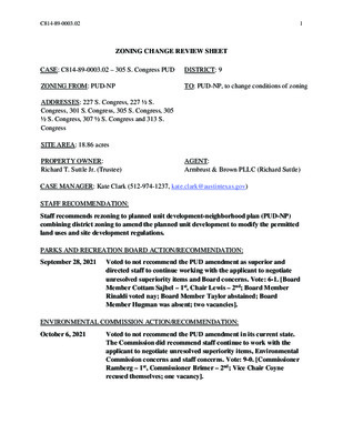
C814-89-0003.02 1 ZONING CHANGE REVIEW SHEET CASE: C814-89-0003.02 – 305 S. Congress PUD DISTRICT: 9 ZONING FROM: PUD-NP TO: PUD-NP, to change conditions of zoning ADDRESSES: 227 S. Congress, 227 ½ S. Congress, 301 S. Congress, 305 S. Congress, 305 ½ S. Congress, 307 ½ S. Congress and 313 S. Congress SITE AREA: 18.86 acres PROPERTY OWNER: Richard T. Suttle Jr. (Trustee) AGENT: Armbrust & Brown PLLC (Richard Suttle) CASE MANAGER: Kate Clark (512-974-1237, kate.clark@austintexas.gov) STAFF RECOMMENDATION: Staff recommends rezoning to planned unit development-neighborhood plan (PUD-NP) combining district zoning to amend the planned unit development to modify the permitted land uses and site development regulations. PARKS AND RECREATION BOARD ACTION/RECOMMENDATION: September 28, 2021 Voted to not recommend the PUD amendment as superior and directed staff to continue working with the applicant to negotiate unresolved superiority items and Board concerns. Vote: 6-1. [Board Member Cottam Sajbel – 1st, Chair Lewis – 2nd; Board Member Rinaldi voted nay; Board Member Taylor abstained; Board Member Hugman was absent; two vacancies]. ENVIRONMENTAL COMMISSION ACTION/RECOMMENDATION: October 6, 2021 Voted to not recommend the PUD amendment in its current state. The Commission did recommend staff continue to work with the applicant to negotiate unresolved superiority items, Environmental Commission concerns and staff concerns. Vote: 9-0. [Commissioner Ramberg – 1st, Commissioner Brimer – 2nd; Vice Chair Coyne recused themselves; one vacancy]. C814-89-0003.02 2 SOUTH CENTRAL WATERFRONT ADVISORY BOARD ACTION/RECOMMENDATION: October 18, 2021 Scheduled for South Central Waterfront Advisory Board SMALL AREA PLANNING JOINT COMMITTEE ACTION/RECOMMENDATION: October 25, 2021 Scheduled for Small Area Planning Joint Committee PLANNING COMMISSION ACTION/RECOMMENDATION: To be Scheduled for Planning Commission October 26, 2020 Approved an indefinite postponement request by staff. Vote: 11-0. [Vice Chair Hempel – 1st, Commissioner Azhar – 2nd; Commissioner Shieh was absent]. May 26, 2020 Approved an indefinite postponement request by staff on the consent agenda. Vote: 12-0. [Vice Chair Hempel – 1st, Commissioner Schneider – 2nd; Commissioner Llanes Pulido was off the dais]. December 17, 2019 Approved an indefinite postponement request by staff on the consent agenda. Vote: 10-0. [Commissioner Howard – 1st, Commissioner Flores – 2nd; Commissioners Anderson, Llanes Pulido and Chair Shaw were off the dais]. CITY COUNCIL ACTION: To be Scheduled for City Council ORDINANCE NUMBER: ISSUES On October 6, 2021 this rezoning case was heard by the Environmental Commission. Commission members expressed concerns about balancing the loss of trees with the benefits of proposed environmental and park amenities as well the potential to further increase erosion along the riverbank and impervious cover amounts within the critical water quality zone. For a full list of recommendations and action on this rezoning case, please see Exhibit E: Boards and Commission Actions. On September 28, 2021 this rezoning case was heard by the Parks and Recreation Board. Board Members expressed concerns about the number of remaining details left to be finalized regarding park superiority. They asked staff to continue working with the applicant on unresolved superiority items. On August 24, 2021 the applicant invoked Section 25-2-282(E) of the Land Development Code (LDC) asking to be put on the next available Planning Commission meeting agenda that meets C814-89-0003.02 3 notification requirements. Per the LDC, because this is a Planned Unit Development (PUD) and located within the Waterfront Overlay, prior to the Planning Commission hearing this case it must be reviewed by the Environmental Commission and Small Area Planning Joint Committee. Staff has received communication in favor of and in opposition to the rezoning case. Two neighborhood groups, South River City Citizens (SRCC) and South Central Coalition (SCC), have provided resolutions in opposition to the case. These resolutions and all written or emailed communications related to this rezoning case can be found in Correspondence Received. At the time this report was written, staff had not been able to clear all outstanding comments from the applicant’s latest submittal. Please see Exhibit D: Staff Comment Report Update 2 for the most current list of all comments. CASE MANAGER COMMENTS: This property is located on the east side of S. Congress Avenue, adjacent to and south of Lady Bird Lake. It is approximately 18.86 acres and is currently zoned PUD-NP. To the west across S. Congress Avenue are tracts zoned LI-PDA-NP, CS-1-V-NP, L-NP and PUD-NP. South of the property are tracts zoned LI-NP, CS-1-V-NP, CS-V-NP, CS-NP and PUD-NP. To the east and north of this property is Lady Bird Lake and is not zoned, please see Exhibit A1: Existing Zoning Map and Exhibit A2: Aerial Map. This property is also located within the Greater South River City Combined Neighborhood Planning Area (South River City Neighborhood), the South Shore Sub-District of the Waterfront Overlay and the South Central Waterfront (SCW) district. The Future Land Use Map (FLUM) of the South River City Neighborhood designates this property as “industrial” and therefore requires a neighborhood plan amendment (NPA) to be considered with this rezoning case, see NPA case number: NPA-2019-0022.02. A traffic impact analysis (TIA) is being conducted in conjunction with the rezoning and NPA cases. Currently the TIA is still under reviewed by the Austin Transportation Department (ATD). The SCW district can be identified as the area between S. First Street on the west, Blunn Creek to the east, Lady Bird Lake to the north, and Riverside Drive and East Bouldin Creek to the south, see Exhibit A3: SCW Planning Area. To view the most current version of the Vision Framework Plan, please go the South Central Waterfront Initiative website at: https://www.austintexas.gov/department/south-central-waterfront-initiative. When the PUD amendment was submitted, the Council adopted Vision Framework Plan was in place but the Regulating Plan had not been completed. At the time the application was filed, the applicant told staff it was their goal to follow the intent behind the physical framework components laid out in the Vision Framework Plan. Project Description The applicant is requesting to amend the existing PUD zoning to allow for a mixed-use development to include up to 1,378 residential dwelling units, a 275-key hotel, 1,500,000 square feet of office space and 150,000 square feet of commercial space. They are requesting a C814-89-0003.02 4 maximum building height ranging from 250 to 525 feet. Most of the parking for this development will be achieved through a below grade parking structure. This proposed development will also include approximately 11.84 acres of public realm improvements (Barton Springs Road extension, internal private street network, and parkland and plaza/landscaped areas, please see Exhibit B1: Applicant Summary Letter, Exhibit C1: PUD Exhibits and Exhibit C2: Sub Area Height Map. The SCW Vision Framework Plan “strives to be a model for how a district-wide green infrastructure system paired with quality urban design and an interconnected network of public spaces, streets, lakeside trails and parks can provide a framework for redevelopment. A district approach can also coordinate public and private investments to leverage maximum impact and provide for district-wide value capture to fund affordable housing and other community benefits.” The plan utilizes a holistic approach for redevelopment within the district in that it identifies district-wide goals while acknowledging certain parcels may carry more weight in a particular category to further those goals. The plan provides specific recommendations for creating an interconnected expansion of open spaces, trails and green streets, and for achieving up to 20% of new affordable housing units. The following table illustrates a comparison between the SCW Vision Framework Plan and the proposed PUD amendment. SCW Vision Framework Plan Proposed PUD Program Total: 2,142,900 SF Office: 812,900 SF Residential: 963,500 SF / 962 DU Retail: 112,000 SF Hotel: 254,500 SF Total: 3,515,000 SF Office: 1,500,000 SF Residential: 1,645,000 SF/1,378 DU Retail: 150,000 SF Hotel: 220,000 SF / 275 key Affordable Housing 4.16% Approximately 40 units 4% Approximately 55 units Streets Parking Building Height (please refer to included exhibits) 2.53 acres total 0.82 acres (Barton Springs Road) 1.71 acres (private drives) 3.72 acres total* 1.97 acres (Barton Springs Road) 1.75 acres (private drives) *as of July 2021 PUD submittal 68% structured (podium) parking 32% underground parking 5% surface parking 95% underground 90 feet to 400 feet Exhibit A4: SCW Building Height 250 feet to 525 feet Exhibit C2: Sub Area Height Map C814-89-0003.02 5 SCW Vision Framework Plan Proposed PUD Open Space (Parkland and Plaza Areas) 9.6 acres (Waterfront Park) Open Space Features Bat Viewing Pier Amphitheater Entry Plaza with Interpretive features Overlook Cafe Terrace Pontoon Bridge Landing Pier Natural Beach and Kayak Launch Pavilion Deck and Beer Garden Kayak and Bike Rentals 8.12 acres total* 6.53 acres (deed parkland) 1.59 acres (access easement) *as of July 2021 PUD submittal To be built as a part of the PUD Great Steps Water Quality Ponds To be built with public funds Bat Viewing Area and Pier Great Lawn Water Steps Boardwalk Play Area Affordable Housing Review Staff acknowledges that the applicant’s affordable housing proposal aligns with the SCW Framework Vision Plan which has been a guiding planning document for the overall PUD proposal. This plan established a goal of 20% of residential units constructed within the planning area be set aside for affordable housing. It specifies that not every tract is expected to provide 20% of units as affordable; rather that different tracts will contribute to the plan’s different goals including affordable housing depending on their unique characteristics. The Framework Vision Plan provides estimates of affordable housing contributions by tract, with this tract estimated as providing 4% of on-site units as affordable. Based on this, staff supports the applicant providing at least 4% of rental units as affordable to income-eligible households at 80% MFI for 40 years, subject to the maximum rent rates set by the department. In addition, for any ownership units, staff supports the applicant providing a fee-in-lieu of at least 4% of ownership units at a rate of no less than $450,000 per unit, to be updated based on current market conditions at the time of construction and is amendable to the payout of the fee-in-lieu based on every 25 ownership units sold. Based on unit estimates provided by the applicant, 4% of the PUD residential units would be 55 units. Staff supports the provision of at least 4% of units or 55 units as affordable, whichever of the two is greater. The current expectation of staff and the applicant is that the PUD will be mixed use and provide residential units on-site. In the event though that the project is developed without any residential uses, staff would support the applicant paying a fee-in-lieu of on-site affordable housing to the Housing Trust Fund of not less than an amount equal to the PUD fee rate current at the time of site plan submittal times the bonus square footage dedicated to non-residential use. C814-89-0003.02 6 BASIS OF RECOMMENDATION General Information for Planned Unit Developments Per the LDC the PUD zoning district was established to implement goals of preserving the natural environment, encouraging high quality development and innovative design, affordable housing, and ensuring adequate public facilities and services. The City Council intends PUD district zoning to produce a development that achieves these goals to a greater degree and thus is superior to development which could occur under conventional zoning. To help evaluate the superiority of a proposed PUD, requirements are divided into two categories: Tier 1 which all PUDs must meet, and Tier 2 which provides criteria in 13 categories in which a PUD may exceed code requirements and therefore demonstrate superiority. A PUD does not need to address all criteria listed under Tier 2, and there is no minimum number of categories or individual items required. Whether a proposed PUD is deemed to be superior or not is determined through a balance of community benefits received from the proposed development and the code modifications the applicant is requesting to build their project. Project Superiority The applicant has stated their proposed PUD amendment meets all Tier 1 requirements and many of the Tier 2 categories, please see Exhibit B2: Tier 1 & Tier 2 Superiority Table. Staff is recommending this PUD based on the following superiority items that the applicant has agreed to: • Construct 95% of its required parking within a below grade structure(s) instead of within above ground structures; • Dedicate by deed a minimum of 6.53-acres of land adjacent to Lady Bird Lake; • Dedicate space for the ProjectConnect transit line and/or station; • Dedicate all required right-or-way for the Barton Springs Road extension; and • Move and construct the water quality pond originally proposed under the S. Congress bridge underground to allow for a larger bat viewing area. The applicant and some city departments have not come to an agreement on the proposed superiority items listed in their rezoning application. Please see below for departmental recommendations to be added to obtain superiority within a given area. Parks and Recreation Department (PARD) 1. Land Dedication: A. Dedicate by deed a minimum of 6.78 acres of public parkland along Lady Bird Lake. B. Remove from deed any conditions regarding park programming. C814-89-0003.02 7 C. Dedicate by park easement a minimum of 1.59 acres through plazas and connections for public access; this number may have to increase to include additional park easement areas along ROW and street connections. 2. Park Development A. Include language in the amended PUD ordinance for investment of at least $100 per unit beyond current code (not expressed as a fixed amount). B. Within the amended PUD ordinance, include a park plan that commits to specific improvements. Specified improvements would be committed even if they are beyond investment amount stated in 2A above. Improvements would be tied to and triggered by a phase of development. 3. Parkland Dedication and Improvement Triggers A. Set trigger points for full dedication of park segments. B. Set trigger points for each development stage, in the first half of each phase. 4. Circulation A. Provide pedestrian access from S. Congress Avenue to existing trail and bat viewing area that is fully public, direct and ADA accessible. 5. Water Quality Pond Design A. Remove water quality pond from bat viewing area. B. Demonstrate an amenitized design for water quality ponds and rain gardens within parkland. C. Within the amended PUD ordinance, include a cap on square footage for water quality ponds within the parkland. 6. Land Uses Environmental Review A. Remove the following permitted land uses in parkland: Personal Services, Personal Improvement Services and Pet Services. 1. Except for items listed in the amended ordinance, the PUD will be subject to the code at the time of site plan application. 2. Dedicate by deed the area of approximately 6.53 acres as public parkland located along the Lady Bird Lake frontage; and 1.59 acres of parkland easements. The parkland and easements shall not be restricted. 3. Provide public equitable access from S. Congress ROW to the Hike and Bike trail that does not force visitors through the development. 4. Provide $100 over what is required by current code to build park amenities. C814-89-0003.02 8 5. Complete a Parkland Improvement Agreement that includes maintenance for the water quality ponds located within the parkland. 6. Move and narrow the proposed pier to a location that does not impact existing trees. 7. Relocate the trail a minimum of 25’ from the crest of the slope along the shoreline except at approved shoreline access points and restore the area between the shoreline and trail with riparian or wetland vegetation. Protect the shoreline and vegetation with a split rail fence. 8. Eliminate redundant paths or trails within the critical water quality zone and reduce proposed impervious cover within the CWQZ to 5%, this number will include proposed concrete sidewalks. 9. Preserve or transplant 100% of all Heritage trees and preserve 77% of tree overall on-site. 10. Provide 1000 cubic feet of soil for street trees, can be shared by a maximum of two trees. 11. Proposed trees and shrubs shall be native or adaptive to Central Texas. 12. Provide water quality for all phases of the PUD project. A. The project shall capture the maximum amount of stormwater within the project through cisterns, use this water within the building per Water Forward goals and rain gardens located along the extension of Barton Springs Road to treat ROW. B. Water quality located within the CWQZ will utilize rain gardens that are integrated with the Hike and Bike trail. 13. Connect to and use Austin Water Utility reclaimed water for all non-potable water use within the project. 14. Demonstrate that the building design will reduce the potential for bird/building collisions by using glass with a reflectivity of 15% or less. 15. Enhance City of Austin Dark Sky regulations by adding the following requirements: A. Require warm light: Low Kelvin rated lights (3000 Kelvin or less) are warm and emit less harmful blue-violet light than high Kelvin rated. B. Shielding: outdoor lighting shall be shielded so that the luminous elements of the fixture are not visible from any other property. Outdoor lighting fixtures are not allowed to have light escape above a horizontal plane running through the lowest point of the luminous elements. C. Set a Total Outdoor Light Output: maximum lumens allowed per net acre: Nonresidential property: 100,000 lumens/net acre Residential property: 25,000 lumens/net acre D. Prevent light trespass: Focus light on activity and use activity appropriate lighting. C814-89-0003.02 9 Code Modifications Code modifications are requested by the applicant as a part of the PUD review process in exchange for providing community benefits with the proposed redevelopment. Not all code modifications have to be cleared or agreed upon by staff for a project to move forward. Ultimately the code modifications approved by the City Council will become part of the amended PUD ordinance. The list below contains all the code modifications requested by the applicant from their latest submittal and staff’s recommendation to their request. For a summarized list of all code modification requests not recommended by staff, please see Exhibit B3: Code Modifications Not Recommended by Staff. • Section 25-1-21(105) (Definitions, Site) is modified to allow a site to cross a public street General Requirements and Procedures or right-of-way. a. Recommended by staff. • Chapter 25-1, Article 14 (Parkland Dedication) is modified such that parkland dedication shall be satisfied in accordance with the Open Space Plan. a. Not recommended by staff. Zoning • Section 25-2-491(C) (Permitted, Conditional and Prohibited Uses) is modified to allow the uses provided on Note 5 of the Data Table and Notes sheet as permitted uses within Area 2 of the Property. a. Staff recommends making “General Warehousing and Distribution”, “Light Manufacturing” and “Limited Warehousing and Distribution” land uses conditional and not permitted by right. • Section 25-2-517(A) (Requirements for Amphitheaters) is modified to allow a site plan to be approved administratively that is for the construction of an amphitheater that is associated with a commercial, civic, or residential use. a. Recommended by staff. • Section 25-2-691(C) (Waterfront Overlay (WO) District Uses) is modified to allow the uses provided on Note 4 of the Data Table and Notes Sheet as additional pedestrian- oriented uses. a. Recommended by staff. • Section 25-2-691(D)(2) (Waterfront Overlay (WO) District Uses) is modified such that pedestrian oriented uses are permitted above the ground floor of a structure. a. Recommended by staff. • Section 25-2-692(F) (Waterfront Overlay (WO) Subdistrict Uses) is modified to read: “Not less than 50 percent of the net usable space on the ground level within 50 feet of the C814-89-0003.02 10 exterior wall of a structure directly adjacent to and facing Lady Bird Lake must contain pedestrian oriented uses.” a. Recommended by staff. • Section 25-2-721(B)(2) (Waterfront Overlay (WO) Combining District Regulations) is modified to allow the following additional uses within the primary setback area: charging stations, bike/scooter repair facilities, shared bicycle facilities, restrooms facilities with or without showers, temporary or mobile food and beverage vendors, bike valet, temporary or mobile music vendors, temporary or mobile retail vendors, boat rentals, bicycle rentals, temporary or mobile performance and special events facilities, exercise courses, sports equipment rentals, storm water facilities, and child playscapes/activities. a. Recommended by staff. • Section 25-2-721(C)(1) (Waterfront Overlay (WO) Combining District Regulations) is modified to allow the following additional uses within the secondary setback area: charging stations, bike/scooter repair facilities, shared bicycle facilities, restrooms facilities with or without showers, food and beverage vendors, bike valet, music vendors, retail vendors, boat rentals, bicycle rentals, performance and special events facilities, exercise courses, sports equipment rentals, storm water facilities, and child playscapes/activities. a. Recommended by staff. • Section 25-2-721 (C)(2) (Waterfront Overlay (WO) Combining District Regulations) is modified to allow a maximum of 60 percent impervious cover within the secondary setback area. a. Recommended by staff. • Section 25-2-721(E) (Waterfront Overlay (WO) Combining District Regulations) is waived, however all building glazing systems shall have a 35 percent maximum reflectivity. a. Staff Recommends: a maximum reflectivity of 15% • Section 25-2-721(G) (Waterfront Overlay (WO) Combining District Regulations) is modified so that loading and unloading shall be allowed from any internal driveway and not required to be screened from public view. Loading and unloading locations on private internal driveways are subject to TCM spacing and dimensional requirements subject to ATD approval. a. Recommended by staff. • Sections 25-2-742(B)(1) (South Shore Central Subdistrict Regulations) is modified to reduce the primary setback line to 90 feet landward from the shoreline as shown on the Land Use Plan. a. Recommended by staff. C814-89-0003.02 11 • Section 25-2-742(C)(1) (South Shore Central Subdistrict Regulations) is modified to read “50 feet landward from the primary setback line”. a. Recommended by staff. • Section 25-2-742(D)(1) (South Shore Central Subdistrict Regulations) is modified to read “For a ground level wall that is visible from park land or public right-of-way that adjoins park land, at least 60 percent (exclusive of service areas, loading docks, and parking ramps) of the wall area that is between 2 and 10 feet above grade must be constructed of clear or lightly tinted glass.” a. Recommended by staff. • Section 25-2-742(D)(3) (South Shore Central Subdistrict Regulations) is modified to allow exposed architectural concrete as a natural building material. • Section 25-2-742(G)(3) and (4) (South Shore Central Subdistrict Regulations) does not a. Recommended by staff. apply to the Property. a. Recommended by staff. • Section 25-2-1176(A)(1) (Site Development Regulations for Docks, Marinas and Other Lakefront Uses) is modified to allow the construction of a pier to extend up to 70 feet from the shoreline. a. Not recommended by staff. • Section 25-2-1176(A)(4) is modified to allow for construction of the elements and dimensions shown on the Open Space Map. a. Not recommended by staff. Subchapter E (Design Standards and Mixed Use) • Barton Springs Road extension shall be considered an Urban Roadway for the purposes of complying with Chapter 25-2, Subchapter E – Design Standards and Mixed Use, and will be designed in accordance with the PUD street sections located on Sheet 4. a. Recommended by staff if the PUD cross section (Sheet 4) is amended to reflect four 10’ vehicle travel lanes, a 2’ raised buffer, followed by an 8’ cycle track at minimum, 8’ landscape zone and 11’ sidewalk at minimum. • Development of the Property shall not be subject to Chapter 25-2, Subchapter E – Design Standards and Mixed Use, Article 2.2, Article 2.3, and Article 2.4. a. Recommended by staff, proposed design standards and elements within the applicant’s Tier 1 & Tier 2 Superiority Table match or exceed Subchapter E. • Chapter 25-2, Subchapter E – Design Standards and Mixed Use, Article 2.6 is modified so that loading and unloading shall be allowed from any internal driveway and not required to be screened from Congress Avenue or Barton Springs Road. a. Recommended by staff as long as all loading/unloading is internal and not visible. C814-89-0003.02 12 • Chapter 25-2, Subchapter E – Design Standards and Mixed Use, Article 2.7 is modified so that compliance with Private Common Open Space and Pedestrian Amenity standards are satisfied based on the amount of public open space and parkland provided by the PUD. a. Recommended by staff, staff recommends designating a bat viewing area. • Chapter 25-2, Subchapter E – Design Standards and Mixed Use, Article 2.8 is modified so that the area designated as a drop-off zone is excluded from the 50% calculation when determining the shaded sidewalk requirement. a. Recommended by staff. • Development of the Property is exempt from Chapter 25-2, Subchapter E – Design Standards and Mixed Use, Article 3.2.2.E. a. Recommended by staff, proposed design standards and elements within the applicant’s Tier 1 & Tier 2 Superiority Table match or exceed Subchapter E. Subdivision • Section 25-4-51 (Preliminary Plan Requirement) is modified such that a preliminary plan is not required for the extension of Barton Springs Road. a. Not recommended by staff. • Section 25-4-171(A) (Access to Lots) is modified to allow a lot not to abut a dedicated public right of way so long as the corresponding lot fronts on a private street or driveway. a. Recommend by staff Site Plan a. Recommended by staff Transportation • Section 25-5-81(B) (Site Plan Expiration) is modified such that a site plan expires eight (8) years after the date of its approval, unless Section 25-5-81 subsections (C), (D), or (E) are met. • Section 25-6-381 (Minimum Frontage for Access) is modified to allow access to Congress Avenue which is classified as a major roadway. a. Recommended by staff on the condition that only one single lane right-out only vehicle egress is permitted for the entirety of the S. Congress Avenue frontage. • Section 25-6-477 (Bicycle Parking), 25-6-478 (Motor Vehicle Reductions General), 25-6- 532 (Off-Street Loading Standards), and Appendix A (Tables of Off-Street Parking and Loading Requirements) are modified such that the minimum off street parking, bicycle parking, and loading requirements shall be determined by the director subject to a Transportation Demand Management Plan approved as part of the PUD. a. Recommended by staff if the TIA final memo is memorialized as a public restrictive covenant. C814-89-0003.02 13 • Section 25-6-532 (Off-Street Loading Standards) is modified to allow shared loading and unloading spaces for the various uses within the PUD regardless of where the use or loading and unloading is located within the PUD. a. Recommended by staff. • Transportation Criteria Manual (“TCM”) Section 1.3.1(B) (General Design Criteria) is modified to allow a minimum horizontal radii of 150 feet for Barton Springs Road. a. Not recommended by staff. • TCM Section 1.3.1(D)(2) (General Design Criteria) is modified to allow a minimum approach tangent and intersection skew of 120° from Congress Avenue. a. Not recommended by staff. • TCM Section 1.3.2 (Classification Design Criteria) is modified to allow the construction of Barton Springs Road to adhere to the street cross-sections within the PUD. a. Not recommended by staff. • TCM Table 5-2 (Type II Commercial Driveway Criteria) is modified to allow the construction of the driveways to adhere to the cross sections within the PUD. a. Not recommended by staff. Environment • Section 25-8-63(C)(11)(a)(iv) (Impervious Cover Calculations) is modified so that a parking structure can be excluded from impervious cover calculations if it is below the finished grade of the land after it is constructed and is covered by soil with a minimum depth of two feet and an average depth of not less than four feet and at the time of site plan the applicant submits documentation that the discharge or impoundment of groundwater from the structure, if any, will be managed to avoid adverse effects on public health and safety, the environment, and adjacent property. Furthermore the parking structure may exceed 15% of the site. a. Recommended by staff • Section 25-8-261 (Critical Water Quality Zone Development) and the ECM is modified to allow development within the Critical Water Quality Zone that is in accordance with the PUD Land Use Plan and Open Space Plan. This includes vegetation filter strips, rain gardens, bio-filtration ponds, stormwater outfall structures, park improvements including hard surface trails, bicycle trails, picnic facilities, playscapes, concessions including food and beverage vendors, bicycle rentals, sports equipment rentals, boat rentals, dining facilities, performance and special event facilities, boardwalks, sidewalks, pavilions, gazeboes, restrooms, exercise equipment and courses, water steps, boat landings, piers, rail station, stream bank stabilization to the proposed steps. Construction of such facilities within the CWQZ shall not exceed a maximum of 24.5% impervious cover. a. Not recommended by staff. C814-89-0003.02 14 • Section 25-8-261(H)(4) (Critical Water Quality Zone Development) is modified to allow green stormwater quality controls (as defined by ECM) within 50 feet of the shoreline of Lady Bird Lake and within the 100-year floodplain. a. Not recommended by staff, no longer needed with current conceptual plan. • Section 25-8-367 (Relocation of Shoreline Between Tom Miller Dam and Longhorn Dam) is modified to allow the administrative approval of the steps on the shoreline as opposed to seeking City Council approval as required by code. a. Not recommended by staff. • Environmental Criteria Manual Section 1.13.5(B)(3) (Recommended Guidance for Appropriate Method for Shoreline Stabilization and Modification) is modified to allow structural modification of the shoreline and associated steps as shown in the Open Space Map. The dimension of the water steps and bulkhead are not to exceed 100 linear feet of shoreline frontage and not to exceed 30 feet inland. Steps going into the water are allowed if in compliance with Section 25-2-1174 and the Environmental Criteria Manual 1.13 and LDC 25-8-368. • All signage on the Property shall comply with the requirements of Section 25-10-129 a. Not recommended by staff. Sign Regulations (Downtown Sign District Regulations). a. Recommended by staff. EXISTING ZONING AND LAND USES: Zoning Land Uses Site PUD-NP North Not Zoned Industrial Lady Bird Lake South LI-NP, CS-1-V-NP, CS-V-NP, CS-NP and PUD-NP Automotive repair services; administrative and business offices; and personal services. East Not Zoned Lady Bird Lake West LI-PDA-NP, CS-1-V-NP, L-NP and PUD-NP Administrative and business offices; general retail sales (general); hotel-motel; and restaurant (general). NEIGHBORHOOD PLANNING AREA: Greater South River City Neighborhood Plan (South River City). TIA: A traffic impact analysis was required for this rezoning case and still under review. C814-89-0003.02 15 WATERSHED: Lady Bird Lake OVERLAYS: ADU Approximate Area Reduced Parking, Capitol View Corridors (South Congress at east Live Oak), Residential Design Standards, Scenic Roadways Overlay (Barton Springs Road), Waterfront Setbacks Overlay (South Shore Central). SCHOOLS: Travis Heights Elementary, Lively Middle and Travis High Schools NEIGHBORHOOD ORGANIZATIONS Austin Independent School District Austin Neighborhoods Council Bike Austin Bouldin Creek Neighborhood Association Bouldin Creek Neighborhood Planning Team Greater South River City Combined Neighborhood Plan Contact Team Homeless Neighborhood Association Neighborhood Empowerment Foundation Preservation Austin SELTexas City of Austin Downtown Commission Sierra Club, Austin Regional Group Downtown Austin Alliance South Central Coalition Downtown Austin Neighborhood Assn. (DANA) Friends of Austin Neighborhoods South River City Citizens Association Waterloo Greenway Zoning Committee of South River City Citizens AREA CASE HISTORIES: Number Request Commission City Council C14-2017-0026 Area Wide Plan To add Garage Placement provisions to Bouldin Creek Neighborhood Area Plan Recommended adding placement too planning area Case was indefinitely postponed by staff; Council did not take action C814-89-0003.02 16 Number Request Commission City Council C814-2017-0001 425 W. Riverside Drive PUD CS-1-V-NP to PUD- NP for Mixed Uses with associated improvements Approved PUD-NP with additional direction to staff and revisions to the ordinance (5/10/2018) Recommended staff recommendation with additional direction provided by 1) the Environmental Commission, 2) the Small Area Planning Joint Committee, and 3) the South Central Waterfront Advisory Board Working Group C814-2012-0071 LI-NP to PUD-NP Recommended PUD- NP Approved PUD-NP (10/18/2012) L-V-NP and L-NP to PUD-NP Recommended PUD- NP Approved PUD-NP (10/16/2008) 422 W. Riverside C814-2008-0165 222 E. Riverside Drive PUD C14-2007-0224 C14-2007-0220 Area Wide Plan C814-06-0106 C814-06-0106.01 C814-06-0106.02 208 Barton Springs PUD To add VMU to various tracts in the Greater South River City and the Bouldin NP Areas Recommended adding V to zoning districts. Approved adding VMU to tracts (12/13/2007) CS-1-NP and L-NP to PUD-NP Recommended PUD- NP with conditions. Approved PUD-NP (2/15/2007) Amendments were to add additional permitted uses within PUD. Recommended both amendments. Approved both amendments (9/26/2013 and 8/7/2014) C14-99-0069 LI to LI-PDA 200 S. Congress Recommended LI- PDA. Approved LI-PDA (10/26/2000) C14-73-041 C2 and D to C - Approved C (2/14/1974) C814-89-0003.02 17 RELATED CASES: NPA-2019-0022.02: This is the neighborhood plan amendment being considered in conjunction with this rezoning case. C14-05-0139: This was the creation of the Greater South River City Neighborhood Plan which included the South River City and St. Edwards neighborhood areas. This property is located within the boundaries of the South River City neighborhood (ordinance no. 20050929-Z003). C814-89-0003.01: Amended the site plan (Phases 2 through 4) originally submitted with the PUD and added three new sheets to the plan set (ordinance no. 931202-H). C814-89-0003: This was the creation of the original PUD for this property (ordinance no. 890720-E). PUD regulations included a list of permitted and prohibited land uses, site development regulations, roadway improvements and phasing plan. C14-72-161: This case involved rezoning an area of 52.6 acres on the south side of the river from C (commercial) and D (industrial) to L (lake district). EXISTING STREET CHARACTERISTICS: Name Existing ROW ASMP Required ROW Pavement ASMP Sidewalks Bicycle Classification Route Capital Metro (within ¼ mile) ~60’ 116’ 61’ 3 Yes Yes Yes Congress Avenue (North of Barton Springs) Congress Avenue (South of Barton Springs) New Bridge Over Lady Bird Lake S. Central Waterfront ~131’ 130’ 87’ 3 Yes Yes Yes N/A 120’ N/A 3 Yes Yes Yes N/A 60’ N/A 1 Yes Yes Yes C814-89-0003.02 Name Existing ROW ASMP Required ROW Pavement ASMP Sidewalks Bicycle Classification Route 18 Capital Metro (within ¼ mile) Local Street 1 S. Central Waterfront Local Street 2 S. Central Waterfront Local Street 3 Barton Springs Road (extension) N/A 60’ N/A 1 Yes Yes Yes N/A 60’ N/A 1 Yes Yes Yes N/A 92’ N/A 2 Yes Yes Yes INDEX OF EXHIBITS TO FOLLOW AFTER MASTER REPORT Exhibit A1. Existing Zoning Map Exhibit A2. Aerial Map Exhibit A3. SCW Planning Area Exhibit A4. SCW Building Height Exhibit B1. Applicant’s Summary Letter (Submitted July 25, 2019) Exhibit B2. Tier 1 & Tier 2 Superiority Table (Submitted July 12, 2021) Exhibit B3. Code Modifications Not Recommended by Staff Exhibit C1. PUD Exhibits (Submitted July 12, 2021) Exhibit C2. Sub Area Height Map Exhibit D. Staff Comment Report Update 2 Exhibit E. Boards and Commission Actions INDEX OF ATTACHMENTS TO FOLLOW AFTER STAFF COMMENT REPORT Attachment A: Educational Impact Statement from AISD Attachment B: Carbon Impact Statement Correspondence Received P CBD 2 1 9 11 CBD 12 1 3 4 2 CBD 8 9 7 6 5 T S S O Z A R B 3 J22 E V A S S E R G N O C 12 11 CBD 1 2 CBD 4 5 6 7 N A S 12 D V L B O T N I C A J 1 2 7 CBD 9 10 8 3 CBD 6 1 CBD 4 2 DMU 1 2 3 4 8 7 6 5 1 2 3 CBD 4 1 2 6 3 8 7 T S Y T I IN R T 1 1 E CESAR CHAVEZ ST 2 3 2 6 CBD-CURE 2 3 5 4 CBD 1 2 3 4 5 6 CS WILLOW ST 3 2 1 1 1 C814-89-0003.02 3F 2F P-NP 1 P-NP T T S S S 1 2 PUD-NP PUD-NP 5A CS-1-V-NP 1 5B 4 1F 3 LI-PDA-NP CS-1-V-NP 1F E V S A S E R G N O S C 3F W R I V E R LI-NP 3F S I D PUD-NP E D R 2F 2F O D AVE H AY W O CS-1-NP P-NP 1 CS-1-V-NP 3A CS-1-NP 6 B A R T O N S P R I N G S R D 1 CS-1-V-NP PUD-NP 1 CS-1-V-NP 3 2A 2 CS-1-V-NP J21 CS-1-V-NP 3 3 LI-NP ONE CS-NP 1 4 2 CS-1-V-NP CS-1-V-NP CS-V-NP A 1 14 UNZ E V A S S E R G N O C S E R I V 2 E R B CS-V-CO-NP 1 S I D E D R CS-1-V-NP L-NP CS-MU-V-NP A CS-V-CO-NP CS-CO-NP 2 1 9 SF-3-NCCD-NP MF-4-NCCD-NP MF-1-NCCD-NP L-V-NP 7 2 L-NP L-NP 3 ± 1'' = 400' SUBJECT TRACT ZONING BOUNDARY ! ! ! ! ! ! PENDING CASE CREEK BUFFER 305 S. Congress ZONING CASE#: LOCATION: SUBJECT AREA: GRID: MANAGER: C814-89-0003.02 305 S. Congress Ave 18.86 ACRES J21 KATE CLARK This map has been produced by the Communications Technology Management Dept. on behalf of the Planning Development Review Dept. for the sole purpose of geographic reference. No warranty is made by the City of Austin regarding specific accuracy or completeness. 2 CBD 1 P 1 CBD A T S E C R IE B 15 18 T Y S E AIN R 11 9 7 5 3 CBD 8 6 4 11 5 DMU-CO 14 11 15 12 17 19 10 21 8 23 9 20 22 24 26 28 7 5 3 1 2 6 4 30 P CBD 2 1 9 11 CBD 12 1 3 4 2 CBD 8 9 7 6 5 T S S O Z A R B 3 J22 E V A S S E R G N O C 12 11 CBD 1 2 CBD 4 5 6 7 N A S 12 D V L B O T N I C A J 1 2 7 CBD 9 10 8 3 CBD 6 1 CBD 4 2 DMU 1 2 3 4 8 7 6 5 1 2 3 CBD 4 1 2 6 3 8 7 T S Y T I IN R T 1 1 E CESAR CHAVEZ ST 2 3 2 6 CBD-CURE 2 3 5 4 CBD 1 2 3 4 5 6 CS WILLOW ST 3 2 1 1 1 C814-89-0003.02 3F 2F P-NP 1 P-NP T T S S S 1 2 PUD-NP PUD-NP 5A CS-1-V-NP 1 5B 4 1F 3 LI-PDA-NP CS-1-V-NP 1F E V S A S E R G N O S C 3F W R I V E R LI-NP 3F S I D PUD-NP E D R 2F 2F O D AVE H AY W O CS-1-NP P-NP 1 CS-1-V-NP 3A CS-1-NP 6 B A R T O N S P R I N G S R D 1 CS-1-V-NP PUD-NP 1 CS-1-V-NP 3 2A 2 CS-1-V-NP J21 CS-1-V-NP 3 3 LI-NP ONE CS-NP 1 4 2 CS-1-V-NP CS-1-V-NP CS-V-NP A 1 14 UNZ E V A S S E R G N O C S E R I V 2 E R B CS-V-CO-NP 1 S I D E D R CS-1-V-NP L-NP CS-MU-V-NP A CS-V-CO-NP CS-CO-NP 2 1 9 SF-3-NCCD-NP 2 CBD 1 P 1 CBD A T S E C R IE B 15 18 T Y S E AIN R 11 9 7 5 3 CBD 8 6 4 11 5 DMU-CO 14 11 15 12 17 19 10 21 8 23 9 20 22 24 26 28 7 5 3 1 2 6 4 30 MF-4-NCCD-NP MF-1-NCCD-NP L-V-NP 7 2 Copyright nearmap 2015 L-NP L-NP 3 ± 1'' = 400' SUBJECT TRACT ZONING BOUNDARY ! ! ! ! ! ! PENDING CASE CREEK BUFFER 305 S. Congress ZONING CASE#: LOCATION: SUBJECT AREA: GRID: MANAGER: C814-89-0003.02 305 S. Congress Ave 18.86 ACRES J21 KATE CLARK This map has been produced by the Communications Technology Management Dept. on behalf of the Planning Development Review Dept. for the sole purpose of geographic reference. No warranty is made by the City of Austin regarding specific accuracy or completeness. T T S S S 1 E V S A S E R G N O S C R I V E R S I D E D R BARTON SPRINGS RD Hyatt Hotel Hyatt Hotel Embassy Suites Embassy Suites Austin American Austin American Statesman Statesman City of Austin City of Austin One Texas Center One Texas Center State of Texas State of Texas T T S S S 1 E BOULDIN CREEK L a d y B i r d L a k e E V S A S E R G N O S C South Central Waterfront Area Plan Boardwalk Principal Streets Creeks South Central Waterfront Norwood tract, city-owned Related Planning Efforts Auditorium Shores Master Plan Bubble Diagram Boardwalk Construction 2012-2013 Imagine Austin Growth Concept Plan Neighborhood Planning Areas BOULDIN CREEK SOUTH RIVER CITY South Central Waterfront Context University of Texas State Capital Downtown City Hall 0 500 1,000 Feet 2,000 ¸ Joe's Crab Shack Joe's Crab Shack City-owned City-owned Norwood tract Norwood tract k e e r C RIV E R n n u l B SID E D R Plan Area South Congress This product is for informational purposes and may not have been prepared for or be suitable for legal, engineering, or surveying purposes. It does not represent an on-the-ground survey and represents only the approximate relative location of property boundaries. It has been produced by the Planning and Development Review Department for the sole purpose of geographic reference. No warranty is made by the City of Austin regarding specific accuracy or completeness. CITY OF AUSTIN PLANNING AND DEVELOPMENT REVIEW DEPARTMENT 9/17/2013 x i d n e p p A 48 | South Central Waterfront ARMBRUST & BROWN, PLLC ATTORNEYS AND COUNSELORS 100 CONGRESS AVENUE, SUITE 1300 AUSTIN, TEXAS 78701-2744 512-435-2300 FACSIMILE 512-435-2360 July 24, 2019 Richard T. Suttle, Jr. (512) 435-2300 rusttle@abaustin.com VIA HAND DELIVERY Jerry Rusthoven Assistant Director City of Austin Planning and Zoning Department 505 Barton Springs Road, 5th floor Austin, TX 78704 Re: PUD Amendment Application for 305 S. Congress (C814-89-0003) (the "Application") Dear Mr. Rusthoven: This Application is submitted to amend Ordinance No. 890720-E, associated with zoning case C814-89-0003, for property located at 305 S. Congress Avenue (the "Property"). The Property is located within the boundaries of the South Central Waterfront Vision Framework Plan ("SCWP"), adopted by City Council on June 16th 2016. The SCWP provides a framework for future redevelopment of property within its boundaries. The project is designed to follow the guiding principles of the SCWP, with deviations to the maximum height and density to allow the proposed project to build upon and enhance the objectives of the SCWP. The amendment includes: (i) replacing Exhibit B - PUD Planned United Development General Land Plan Sheets 1 - 10, (ii) modify the conditional and prohibited uses, and (iii) revise the development intensity proposed for the site. The Property comprises 18.86 acres of land, and is divided into three legal lots known as: (i) Lot 1, Block A, Waterford Subdivision, (ii) Lot 1, Waterford II Subdivision, and (iii) Lot 1, Miller Subdivision. The Property was formally used as a printing and publishing facility and is currently used as a newspaper office which consists of a 3-story building totaling 333,931 square {W0897913.3} feet, with surface parking and related facilities. Current entitlements allow a total buildout of 660,000 square feet with a maximum building height of 96 feet. Current improvements encroach into the Critical Water Quality Zone ("CWQZ"), and the It should be noted that this PUD Waterfront Overlay primary and secondary setbacks. amendment proposes to remove existing building, surface parking areas and other impervious improvements from the CWQZ and the primary and secondary setbacks. The proposed project will include development superior than what currently exists on the Property. The project will consist of a mixed-use development of approximately 1,500,000 square feet of office, 1,378 residential dwelling units (totaling 1,645,000 square feet), a 275 key hotel (totaling 220,000 square feet.), and 150,000 square feet of retail for a total of 3.5 million square feet of gross floor area (the "Project"). The majority of the parking for the Project will be achieved through a below grade parking structure. The Project will include 11.96 acres of public realm improvements, which include the extension of Barton Springs Road, an internal loop road, pubHc parkland, plazas, and a boardwalk: extending over the shoreline that will connect to a· landing which could serve as a future connection point to a proposed pedestrian bridge identified by the Waller Creek Conservancy. The new parkland area will enhance the shoreline of Lady Bird Lake and expand upon the existing Anne and Roy Butler Hike-and-Bike Trail to create a state of the art waterfront park that embodies the vision of the SCWP. This expansion will create an attractive and lively pedestrian environment that will enrich the connection to and along the waterfront. As recommended in the SCWP, the extension of Barton Springs Road will provide access and connectivity to the surrounding area and waterfront. The SCWP contemplates that the extension of Barton Springs Road would be constructed partially on the Property and the adjoining tract to the south. However, due to timing issues the property owner to the south has elected not to participate with the roadway improvement. Because of this, the developer plans to accommodate the improvements associated with the extension entirelr on its site. The Project will deviate from the development assumptions in the SCWP in two ways - maximum height and density. The SCWP calls for a maximum building height of 400 feet, while the Project proposes a maximum building height of 525 feet. It should be noted that the Property will be limited to the north by the waterfront park and to the south by the extension of Barton Springs Road. This will leave approximately 6.25 acres of developable area. The test scenario included in the Appendices of the SCWP assumes a density of 2,142,900 square feet of gross floor area with the majority of the parking contained within above grade podium parking structures. The Project proposes approximately 3.5 million square feet of gross floor area with below grade parking and an option to add some above grade parking. As a result, the overall incremental increase in density proposed is 1,357,100 square feet. We will be coordinating with your staff on a review for the justification of the incremental increase from the SCWP. Below is a list of the information that has been provided to assist with your review. A Superiority Table is included with the Application that outlines all of the PUD Tier One and Tier Two requirements in order to show how the Project meets or exceeds city code. In order to achieve the objectives of the SCWP, Exhibit "A" includes a list of code modifications that are necessary for the Project. These code modifications may not be exhaustive and may be modified {W0897913.3} after consultation with your staff. It is our intent to modify all necessary code and rule sections to facilitate the development of the Project. Attached are the following: 1. Zoning Application. 2. Neighborhood Plan Amendment Application. 3. Survey showing existing conditions. 4. Tax plat and tax certificates. 5. Twenty-four copies of the following: a) Exhibit 1 -Existing Zoning Map b) Exhibit 2 - Property Boundary Map c) Exhibit 3 - Development Parcel Map d) Exhibit 4 - Open Space Map e) Exhibit 5-Right-of-Way Map f) Exhibit 6 - Street Section - Barton Springs Extension g) Exhibit 7 - Street Section - South Congress Edge Condition h) Exhibit 8 -Land Use Data Table i) Superiority Table Please feel free to contact me at 512-435-2310 or Amanda Morrow at 512-435-2368 with any questions. We request a meeting at your convenience to discuss the Application. Respectfully, ARMBRUST cc: Mark Rosenbaum Anne Lofye Andy Pastor Kirk Rudy Bryce Miller Jamil Alam Amanda Morrow {W0897913.3} July 8, 2021 Open Space Tier One Requirement Meet the objectives of the City Code Superior The PUD meets the objectives of City Code and the SCWP. 305 S. Congress PUD Tier 1 & Tier 2 Superiority Table Provide for development standards that achieve equal or greater consistency with the goals in Section 1.1 (General Intent) than development under the regulations in the Land Development Code. Section 1.1 states that "[t]his division provides the procedures and minimum requirements for a planned unit development zoning district to implement the goals of preserving the natural environment, encouraging high quality development and innovative design, and ensuring adequate public facilities and services. Provide a total amount of open space that equals or exceeds 10 percent of the residential tracts, 15 percent of the industrial tracts, and 20 percent of the nonresidential tracts within the PUD, except that: 1.a detention or filtration area is excluded from the calculation unless it is designed and maintained as an amenity; and 2. the required percentage of open space may be reduced for urban property with characteristics that make open space infeasible if other community benefits are provided. The PUD creates a framework of development blocks linked by pedestrian oriented streets and pedestrian connections, and a thoughtful integration with the context set by the South Congress Avenue Bridge and Lady Bird Lake. A new publically accessible park will be created, advancing the vision of the SCWP. The PUD includes multiple development phases, various buildings situated on top of below grade parking structures with numerous areas that link to public spaces. With a holistic and integrated approach to the visually connected ground floor and the adjacent public realm, specific building and public space design will respond with activation, flexibility, individuality, sustainability, creativity, and architectural expression. The PUD will include a variety of open space that will achieve the intent of the SCWP. The PUD will expand the existing open space areas whereby creating great public spaces by establishing publicly accessible lakefront park and links to the larger Hike-and-Bike Trail system. This park has been inspired by the SCWP and encompasses a series of open space rooms and unique park portals along the lakefront. This will include spaces with civic/cultural, neighborhood, nature/play and active recreation. Green Building Neighborhood Plans, Historic Areas, Compatibility Comply with the City's Planned Unit Development Green Building Program Be consistent with applicable neighborhood plans, neighborhood combining district regulations, historic area and landmark regulations, and compatible with adjacent property and land uses Environmental Preservation Provide for environmental preservation and protection relating to air quality, water quality, trees, buffer zones and greenbelt areas, critical environmental features, soils, waterways, topography, and the natural and traditional character of the land The PUD will achieve a 2-Star AEGB rating. There are no applicable neighborhood combining district regulations, historic areas, or landmark regulations for the Property. However the Property is located in the Greater South River City neighborhood planning area, which designates this site as "industry" on the FLUM. It should be noted that when the FLUM was adopted in 2005, there was little discussion as to the future use of the Property. Since its adoption, City Council has enacted the South Central Waterfront Vision Framework Plan which encourages mixed use development of the Property consisting of: shops, restaurants, residential, office and hotel uses. The PUD is designed to comply with the SCWP. The PUD is also compatible with the adjacent properties and land uses. The PUD proposes to remove existing buildings, surface parking areas and other impervious improvements from the Critical Water Quality Zone, Waterfront Overlay primary and secondary setbacks. The PUD proposes to create a lively, attractive pedestrian environment by expanding open space and creating great public places, enhancing connections to and along the waterfront and acting as a catalyst for implementing a new district at the entrance to downtown. The PUD also includes recommendations for enhancing habitat for birds, mammals, amphibians, insects and fish within the context of new public open space. In addition, coordination will continue with the Bat Conservation International to preserve the bat colony and enhance the viewing areas as well as provide for habit education. All of which will enhance the ecological conditions along the shoreline and aid in the restoration and water quality of Lady Bird Lake. Public Facilities Provide for public facilities and services that are adequate to support the proposed development including school, fire protection, emergency service, and police facilities. The PUD proposes to include the following public facilities: Landscaping Exceed the minimum landscaping requirements of the City Code. Transportation, Connectivity Provide for appropriate transportation and mass transit connections to areas adjacent to the PUD district and The PUD will provide for the follwing: mitigation of adverse cumulative transportation impacts with sidewalks, trails, and roadways. • Extension of Barton Springs Road through the site. Modifications to the street cross-section are proposed in order to allow implementation within the Property and enhancements to the specific street section design while maintaining the functionality goals. • The PUD will achieve access and connectivity to the surrounding area by establishing a lively, attractive pedestrian environment; expanding open space and creating great public places, enhancing connections to and along the waterfront and implementing a new mixed-use district at the entrance to downtown. • The PUD achieves the SCWP vision of a physical framework with a connected network of streets, pedestrian connections, and open spaces that make for a great public realm. The PUD will exceed the minimum landscape requirements of the Code and require the utilization of native and adapted species and non-invasive plants per the 2018 Grow Green Program. As currently contemplated, the PUD scores a 0.42 using the Draft COA Functional Green Scoring System. This score is approximately 35% greater than the Goal Target Score as defined by the Austin LDC Code Functional Green Overview - Draft 3 from February 2018 • Future mass transit connections, including the potential for a future Capital Metro rail station, which may include the possibility of a transit connection across Lady Bird Lake. • Adverse cumulative transportation impacts will be mitigated with sidewalks, new pedestrian connections from Congress Avenue, new and enhanced trails through the public open space areas along the lake, providing a landing area onsite for a future pedestrian and bicycle bridge across Lady Bird Lake, and a new network of roadways including the extension of Barton Springs Road and a network of internal drives within the site that will work well with adjacent SCW properties once they are ready for redevelopment. • Incorporate physical and programmatic measures to reduce parking demand and auto trips to mitigate impact. Shared Parking strategies will take advantage of the complementary parking demands of different types of users to achieve an 18% +/- reduction in parking demand compared to unshared parking. A comprehensive Transportation Demand Management (TDM) program will achieve a further 25% +/- reduction compared to shared parking. • A majority of parking needs will be met with below-grade parking. Prohibit Gated Roadways Prohibit gated roadways The PUD will not include any gated public right-of-ways. Historical Preservation Protect, enhance, and preserve areas that include structures or sites that are of architectural, historical, archaeological, or cultural significance The PUD includes the incorporation of new public open space areas designed to enhance the use of waterfront trails which are of cultural significance. The PUD will also enhance areas next to S. Congress Avenue bridge by creating large civic gathering spaces and careful consideration of the placement of nearby buildings within the PUD to respond to the cultural significance of the bat colony and seasonal bat watching. PUD Size Include at least 10 acres of land, unless the property is characterized by special circumstances, including unique topographic constraints The PUD exceeds the 10 acre minimum requirement. July 8, 2021 Commercial Design Standards Comply with Chapter 25-2, Subchapter E (Design Standards and Mixed Use) The PUD will comply with Subchapter E of the City's Land Development Code, except as modified by the PUD. Inside the urban roadway boundary depicted in Figure 2, Subchapter E, Chapter 25-2 (Design Standards and Mixed Use), comply with the sidewalk standards in Section 2.2.2., (Core Transit Corridors: Sidewalks And Building Placement) Street sections have been enhanced and modified to meet the objectives of the SCWP. Contain pedestrian-oriented uses as defined in Section 25-2-691(C) (Waterfront Overlay District Uses) on the first floor of a multi-story commercial or mixed use building. The PUD will comply with pedestrian-oriented uses on the first floor of a multi-story commercial or mixed use building. Tier Two Requirement Provides open space at least 10% above the requirements of Section 2.3.1.A. ( Minimum Requirements ). Alternatively, within the urban roadway boundary established in Figure 2 of Subchapter E of Chapter 25-2 ( Design Standards and Mixed Use ), provide for proportional enhancements to existing or planned trails, parks, or other recreational common open space in consultation with the Director of the Parks and Recreation Department. Required: Equals or exceeds 10 percent of the residential tracts, 15 percent of the industrial tracts, and 20 percent of the nonresidential tracts within the PUD Superior The PUD will meet the objectives of the SCWP by including approximately ____ acres of parkland, which includes the inundated land, that will be connected by plazas and landscape areas of approximately _____ acres. This represents approximately ______ of the site area. Some of the key components that make up this area may include, but are not be limited to: • The Great Lawn. • The Great Steps – a new public plaza that transitions from Congress Avenue to the proposed park. • A Boardwalk along the shoreline. • A Pier for bat viewing. • The potential Waller Creek pedestrian bridge landing. • Enhanced Hike & Bike trail. • Water steps. This park commitment is made regardless of the mix of uses once the development is complete. For instance, if the site is only developed with office uses, where no parkland is required, because of the commitment made during this process, the city and community will receive ______ acres of parkland/open space. Environment/Drainage Complies with current code instead of asserting entitlement to follow older code provisions by application of law or agreement. Provides water quality controls superior to those otherwise required by code. Except as modified by the PUD, the PUD shall comply with current code. 100% of the required onsite water quality volume will be treated with green stormwater infrastructure including, but not limited to, rain gardens, biofiltration ponds, and filter strips. Upon redevelopment of the Property, onsite green stormwater quality controls will be provided in the park area to treat a minimum of 82,000 cubic feet of stormwater. Uses green water quality controls as described in the Environmental Criteria Manual to treat at least 50 percent of the water quality volume required by code. The PUD will implement green stormwater quality controls as described in Section 1.6.7 (Green Stormwater Infrastructure) of the ECM to treat 100% of the capture volume as mentioned above. Future water quality controls may include rain gardens, vegetative filter strips, pervious pavers, porous pavement, non required vegetation, and biofiltration ponds. Provides water quality treatment for currently untreated, developed off-site areas of at least 10 acres in size. Subject to approval by the City of Austin and adequate conveyance, the PUD will strive to provide water quality treatment for up to 2.66 acres of off-site area. Provides volumetric flood detention as described in the Drainage Criteria Manual. Detention is not proposed due to the proximity to Lady Bird Lake and the overall reduction in impervious cover. The existing PUD allows for a maximum impervious cover of 73%. The PUD proposes a maximum impervious cover of 68% which is a 5% reduction. Not applicable. There are no unclassified waterways on the property. Reduces impervious cover by five percent below the maximum otherwise allowed by code or includes off-site measures that lower overall impervious cover within the same watershed by five percent below that allowed by code. Provides minimum 50-foot setback for at least 50 percent of all unclassified waterways with a drainage area of 32 acres. Provides drainage upgrades to off-site drainage infrastructure that does not meet current criteria in the Drainage or Environmental Criteria Manuals, such as storm drains and culverts that provide a public benefit. Proposes no modifications to the existing 100-year floodplain. Uses natural channel design techniques as described in the Drainage Criteria Manual. Not applicable. Proposed drainage will be captured and conveyed via storm pipes. No channels are proposed onsite. July 8, 2021 Restores riparian vegetation in existing, degraded Critical Water Quality Zone areas. Informal access to the water's edge is a problem on the site and around Lady Bird Lake. To address this, several strategies will be put in place to direct the user experience away from sensitive vegetation and create an overall better user experience, this includes at least 800 linear feet of protection using a combination of split rail fence, cable fence, boulders, and/or equivalent elements adjacent to the trail and access points. Restoration of 1 acre of riparian woodland forest between the trail and the lake based on principles and practices outlined in the Butler Trail at Lady Bird Lake: Urban Forestry and Natural Area Management Guidelines. Restoration includes the invasive species removal (Ligustrum, Nandina, Chinaberry, Chinese tallow, Arundo, Japanese honeysuckle, lacebark elm, tree of heaven, English Ivy, Asian Jasmine, Vitex, and poison ivy along with other invasives will occupy no more to less than 5% vegetative cover), temporary irrigation, soil amendments where needed (up to 3” of native compost gently raked into upper surface), planting 500 native herbaceous and ground cover plants (1 gallon) planted in clumps 18" on center, as well as seeding 28 pounds of native riparian seed. Restoration of 1,000 square feet of wetland fringe will entail the removal of invasive species, and the establishment of wetland plants were feasible with a total planting of at least 15 obligated and facultative wetland species, planting at least 200 one gallon containers in up to 10 clumps. Restoration of at least 800 square feet of herbaceous riparian vegetation will be planted adjacent to Congress Avenue bridge between the trail and the lake to keep the area open for the bats and to add plant diversity. The planting will include at least 300 plants (1 gallon) planted in clumps 18" on center to reduce weeds. Preparation of the area will include woody species removal, invasive species removal, soil amendments as necessary, and temporary irrigation instillation. Inclusion of at least 30 native pollinator and prairie species (both planted and seeded) in the green stormwater infrastructure (partially located in the CWQZ) that covers approximately 1 acre of site area. A long- term management plan with appropriate entities that could include the Trail Foundation, bat conservation organizations, or other similar organizations to address the health of the riparian area and repair areas degraded by informal access. At a minimum, the management plan will include bi-annual management of invasive species, increases in diversity through planting and seeding, ensuring native vegetative cover, and annual monitoring. As a result of riparian improvement, the functional floodplain assessment score between the trail and the lakeshore shall be restored and/or managed to a minimum of good with an aspiration to have all areas at Good or Excellent. Where feasible facultative wetland and obligate wetland native species will be used. • The PUD will preserve 75% of the caliper inches associated with native protected size trees and preserves 75% of all native caliper inches (using the City of Austin's Appendix F to define native). • Tree rootzone enhanced conditions: removal of hardscape in half critical rootzones of existing impacted trees that will be preserved in place, unless certain specific conditions seek alternative compliance with the City Arborist due to contextual unique conditions. All plant material for streetscapes and parkland will be sourced from nurseries within 300 miles of the site and trees will be selected from the ECM Descriptive Categories for Tree Species. All other plant material will be selected from Appendix N (City of Austin Preferred Plant List). Removes existing impervious cover from the Critical Water Quality Zone. The PUD will remove impervious cover from the CWQZ which consists of surface parking, stormwater facilities and buildings. Currently there is 14.44% existing impervious cover located within the CWQZ. The PUD proposes to allow approximately 24.5% impervious cover within the CWQZ. Preserves all heritage trees; preserves 75% of the caliper inches associated with native protected size trees; and preserves 75% of all of the native caliper inches. • 100% Heritage Tree Preservation, unless the tree is dead, fatally diseased or poses an imminent hazard. Tree plantings use Central Texas seed stock native and with adequate soil volume. Provides at least a 50 percent increase in the minimum waterway and/or critical environmental feature setbacks required by code. Clusters impervious cover and disturbed areas in a manner that preserves the most environmentally sensitive areas of the site that are not otherwise protected. The PUD proposes to remove existing (and permitted) impervious cover within the CWQZ, and the primary and secondary setbacks, but will add improvements within these areas to implement the SCWP. The improvements proposed within the these areas will be designed to minimize the environmental impacts. Provides porous pavement for at least 20 percent or more of all paved areas for non-pedestrian in non-aquifer recharge areas. Provides rainwater harvesting for landscape irrigation to serve not less than 50% of the landscaped areas. Provides porous pavement for at least 50 percent or more of all paved areas limited to pedestrian use. Crushed granite, or similar soft application, will be used for the majority of the Hike & Bike Trail. Landowner may use raw water from Lady Bird Lake through an existing contract with LCRA to serve as the primary water source for all landscape irrigation within the PUD. Alternative water sources (AC condensate, foundation drain water, rainwater, stormwater or reclaimed water) shall be used as the primary backup supply if the primary raw water source is depleted or unavailable. Reclaimed water shall not be used for irrigation within water quality controls or other prohibited areas. Directs stormwater runoff from impervious surfaces to a landscaped area at least equal to the total required landscape area. The site will direct stromwater runoff from impervious areas to landscaped areas at least equal to the total required landscape area. The project's stormwater goes directly to landscaped areas, biofiltration ponds, and rain gardens minimizing onsite gray infrastructure. July 8, 2021 Art Great Streets Historic Preservation Employs other creative or innovative measures to provide environmental protection. The PUD will provide a 2,000 square foot vertical green wall to reduce the urban heat island effect, increase habitat and overall experience of the site. This will be located within the public realm in an area that receives greater than 4 hours of sunlight and will either be a vine and mesh or living wall system. A pest management plan will be developed and implemented following the guidelines developed by the Grow Green Program in order to limit pesticides onsite. The owner may use raw water from an existing contract with LCRA to serve as the primary water source for all landscape irrigation within the 305 S. Congress PUD. Alternative water sources (AC condensate, foundation drain water, rainwater, stormwater or reclaimed water) shall be used as the primary backup supply if the primary raw water source is depleted or unavailable. Reclaimed water shall not be used for irrigation within water quality controls or other prohibited areas. A completed version of Austin Water’s most current Water Balance Calculator tool must be submitted with any site development permit application for development within the PUD to assess non- potable water demands and alternative water supplies for the development. The owner shall extend a 24” reclaimed water main across the Riverside – Barton Springs Intersection (point of connection to existing reclaimed system under construction), build an off-site reclaimed main from Riverside/Barton Springs to the development, and build internal distribution reclaimed mains to serve buildings within the 305 S. Congress PUD and to facilitate looping of distribution reclaimed mains to the south. Any site development permit application within the 305 S. Congress PUD will comply with the City’s mandatory connection requirements for commercial developments located in proximity to a reclaimed water distribution line. Areas designated as floodplain forest and wetland fringe in the proposed conditions exhibit will be managed as an "enhanced" grow zone. Riparian edge and floodplain forest will be managed to increase biodiversity, create an incredible user experience in highly utilized area, and have ecological health as a primary driver of long-term management of the site. A soil management plan will direct amendments for specific management areas throughout the site associated with soil components, texture and flora to optimize conditions. At a minimum this will apply to: the streetscape, rain gardens, floodplain forest, herbaceous riparian, lawn and wetland fringe. For all biofiltration areas perennial planting areas, the design will be comprised of enhanced pollinator and habitat for birds, bees, hummingbirds and other. Over 50% of the perennial landscape will be comprised of rain gardens used as pocket prairies and pollinator gardens (comprising approximately 1 acre). Plantings will include species from the COA "609S Native Seeding and Planting for Restoration" list, and include at least 30 species appropriate for site conditions recommended by the Xerces Society or equivalent entity for pollinator and/or bird habitat. Austin Energy Green Building Provides an Austin Energy Green Building Rating of three stars or above. Provides art approved by the Art in Public Places Program in open spaces, either by providing the art directly or by making a contribution to the City's Art in Public Places Program or a successor program. The PUD will participate in the Art in Public Places Program by incorporating 2 art pieces into the project. Complies with City's Great Streets Program, or a successor program. Applicable only to commercial, retail, or mixed-use development that is not subject to the requirements of Chapter 25-2, Subchapter E ( Design Standards and Mixed Use ). The PUD is designed to embody the characteristics of the SCWP. This includes enhanced sidewalks and street cross sections to accommodate multi-modal transportation throughout the site. Community Amenities Provides community or public amenities, which may include spaces for community meetings, community gardens or urban farms, day care facilities, non-profit organizations, or other uses that fulfill an identified community need. The PUD will enhance areas next to Congress Avenue bridge by creating large civic gathering spaces and careful consideration of nearby buildings within the PUD to respond to the cultural significance of the bat colony and seasonal bat watching. Provides publicly accessible multi-use trail and greenway along creek or waterway. Transportation Provides bicycle facilities that connect to existing or planned bicycle routes or provides other multi-modal transportation features not required by code. The PUD includes a commitment to include the recommendations of the SCWP by enhancing its shoreline and the Hike-and-Bike Trail system to create a publically accessible park. Taking the recommendations of the SCWP, the PUD has evolved the system of trails and pedestrian and bicycle connections through the park area. This also includes land area for a future bridge connection over Lady Bird Lake. The PUD creates a high-quality street and sidewalk environment through the application and enhancement of street-design guidelines included in the SCWP. This includes pedestrian, bicycle, parking, transit and travel lanes and landscape areas within street sections tailored to their function. This addresses the extension of Barton Springs Road east of Congress Avenue to Riverside Drive, internal circulation drives and an internal “pedestrian” walkway. Pedestrian and bicycle connections also link to the Hike- and-Bike Trail system. The PUD also anticipates future connections, such as a pedestrian bridge and a potential transit link across Lady Bird Lake. Furthermore, bicycle parking for employees and residents will be placed within buildings or below grade parking structures. Personal shower and changing facilities may be incorporated into the project as a public amenity. This PUD also proposes to provide the ability to incorporate bicycle repair facilities. Building Design Exceeds the minimum points required by the Building Design Options of Section 3.3.2. of Chapter 25-2, Subchapter E ( Design Standards and Mixed Use ). Parking Structure Frontage In a commercial or mixed-use development, at least 75 percent of the building frontage of all parking structures is designed for pedestrian-oriented uses as defined in Section 25-2-691(C) ( Waterfront Overlay District Uses ) in ground floor spaces. Affordable Housing Provides for affordable housing or participation in programs to achieve affordable housing. The PUD proposes to place the majority of vehicle parking in below grade structures. The PUD includes a mix of office, residential, retail, restaurants, and hotel activities joining new public realm and open spaces. Pedestrian activities will be placed at the ground floor, along with office, hotel and residential uses. The PUD will commit to dedicating 4% of total rental units developed in the PUD to households earning no more than 80% MFI for a period not less than 40 years from the date a final certificate of occupancy is issued. At the owner’s election, the owner will fulfill one of the below options to satisfy the affordable housing requirements on for-sale condo units: 1. Pay $450,000 per condo unit on 4% of the condo units built as a fee-in-lieu payable pro rata after every 25 units are sold. For example, if the condo building being constructed was 100 condo units, we would owe $450,000 every 25 condo sale closings. After 100 condos are sold, the city will have received a total of $450,000 x 4 units = $1,800,000, or 2. The owner will provide 4% of the total ownership units in the form of an equivalent number of deed restricted for-rent multifamily units within the South Central Waterfront District at 80% MFI for a period not less than 40 years from the date of the first certificate of occupancy for the condo development. Accessibility Provides for accessibility for persons with disabilities to a degree exceeding applicable legal requirements. The PUD proposes 3 ADA accessible access points to the park. Local Small Business Provides space at affordable rates to one or more independent retail or restaurant small businesses whose principal place of business is within the Austin metropolitan statistical area. July 8, 2021 Project Specific Superiority Items - Sustainability: Carton Impact Statement Pilot Project Specific Superiority Items - Transportation Demand Management (TDM) Project Specific Superiority Items -Trees Project Specific Superiority Items - Bat Conservation & Education Project Specific Superiority Items - Trail Design and Construction The PUD will participate in the City's Carbon Impact Statement pilot project and commits to demonstrating leadership by achieving a minimum of 9 points. The carbon impact statement and supporting documentation is included in the PUD update package. The PUD will comply with a TDM plan. The PUD commits to providing all street trees with at least 1,000cf of soil volume per tree. Up to 25% of the soil volume may be shared with adjacent trees in continuous plantings. Where necessary, load bearing soil cells shall be used to meet the soil volume requirement. The city may reduce the minimum soil volume requirement if needed due to utility conflicts or other constructability issues. In this case, the project will still meet the standards in the ECM. At a minimum, street trees will change species at every block length and have a minimum of five (5) street tree species on site and will be from COA Appendix F approved "Street Trees" and "Significant Shade Providers". The plan will direct amendments and conditioning for specific management areas throughout the site associated with soil components, texture, and flora and to optimize those conditions for: streetscape, rain gardens, floodplain forest, herbaceous riparian, lawn, and wetland fringe. 100% of the street trees will be from both the ECM Appendix F “SS – Significant Shade Provider and SE – Streetscape List”. The City Arborist may allow for alternative species on a case by case basis, and may suggest alternative species based on current availability and site and climate condition. The street trees will be a minimum of 3” caliper measured 6” above grade, and the sizing will comply with the standards for nursery stock (ANSI Z60. 1-2014). In addition, no more than 25% of the planted street trees will be from the same species. This commitment is above and beyond the city standard 60% requirement from Appendix F, 1.5” caliper minimum per tree, and 50% maximum being from the species. All plant material for streetscapes and parkland will be sourced from nurseries within 300 miles of the site and trees will be selected from the ECM Descriptive Categories for Tree Species. All other plant material will be selected from Appendix N. With reference from Urban Forest Plan, deliberate measures including design for preservation, relocation of a range of tree sizing and species for forest succession, and a complex phasing plan make for the preservation of 75% of the native caliper inches. The PUD commits to providing all street trees with at least 1,000cf of soil volume per tree. Up to 25% of the soil volume may be shared with adjacent trees in continuous plantings. Where necessary, load bearing soil cells shall be used to meet the soil volume requirement. The city may reduce the minimum soil volume requirement if needed due to utility conflicts or other constructability issues. In this case, the project will still meet the standards in the ECM. At a minimum, street trees will change species at every block length and have a minimum of five (5) street tree species on site and will be from COA Appendix F approved "Street Trees" and "Significant Shade Providers". A soil management plan will direct amendments for specific management areas throughout the site associated with soil components, texture and flora to optimize conditions. At a minimum this will apply to: the streetscape, rain gardens, floodplain forest, herbaceous riparian, lawn and wetland fringe. For all areas within 75' of the shoreline, the PUD proposes dark sky compliant lighting and low/down-lit fixtures to not disturb bat colony as well as optimize bat viewing opportunities. The open area directly east of the Congress bridge between the trail and the shoreline will offer the opportunity to have a herbaceous riparian strip, including eastern gamma grass, switch grass, bushy bluestem, and lindheimer muhly, and be complimented by a combination of pollinator and prairie plants. The area will be treated like floodplain forest with regards to invasive species and soil preparation. The riparian/shoreline trees, 8" or greater, are largley being preserved with the exception of invasive to ensure a safe navigation route for bat arrival and departure to their colony under the Congress Avenue Bridge. The shoreline trees impacted are shown on the Conceptural Open Space Map. Cameras will be mounted and placed onsite for virtual bat viewing and education. Open areas will be provided in front of Congress Avenue Bridge and shoreline for bats to congregate, and for bats to enter and exit the bridge without disruption. The applicant will work with Merlin Tuttle Bat Conservation, Bat Conservation International and/or Austin Bat Refuge including throughout the design and construction process to ensure best practies for protection and enhancement of habitat. The PUD is committed to reconstructing the approximately 1,700 linear feet of the Ann and Roy Butler Hike and Bike Trail to the ‘best practice’ standards put out in the Final Report of the "Safety & Mobility Study" commissioned by The Trail Foundation: https://thetrailfoundation.org/wp-content/uploads/2021/03/BUTLER-TRAIL-Safety- Mobility-Study.pdf (reference Chapter 7 specifically). July 8, 2021 Project Specific Superiority Items - Water Access Project Specific Superiority Items - Environmental Education Signage and Wayfinding Project Specific Superiority Items - Long Term Public Partnership with a Conservancy Management Strategy A major threat to environmental superiority of the site is the regular degradation of areas due to heavy use of the property by the public to view the bats and access the water. To accommodate additional park users, reduce trampling of restored areas, create additional bat viewing areas, and improve the views of Lady Bird Lake and the downtown Austin skyline, this project proposes to construct a pier, a boardwalk, and one hardened water access point. By directing users to these landscape features, other parts of the open space can be protected, restored, and maintained to create an environmentally superior site. The PUD requires an active, vibrant public realm that will be welcoming to all. With this desirable location at the nexus of our city and nature. The PUD is committed to environmental signage and wayfinding that communicates the values of the City of Austin with regard to connection to nature, environmental resilience and sustainability. The PUD will include signage for the following environmental superior elements: Bat Conservation, Water Quality and Riparian Restoration, Tree Preservation and Relocation, Biofiltration Areas, and Pollinator Plants. The PUD applicant is committed to a management plan with the entity that will be maintaining the park system, whether that is the economic development corporation, The Trail Foundation or a combination of above for both proactive maintenance and as maintenance needs/issues arise. The PUD applicant and entity (to be determined) will also be creating an operations and management plan that ensures an enhanced user experience that coincides with ecological functionality. Exhibit B3: Code Modifications Not Recommended by Staff General Requirements and Procedures • Chapter 25-1, Article 14 (Parkland Dedication) is modified such that parkland dedication shall be satisfied in accordance with the Open Space Plan. Zoning • Section 25-2-1176(A)(1) (Site Development Regulations for Docks, Marinas and Other Lakefront Uses) is modified to allow the construction of a pier to extend up to 70 feet from the shoreline. • Section 25-2-1176(A)(4) is modified to allow for construction of the elements and dimensions shown on the Open Space Map. Subdivision • Section 25-4-51 (Preliminary Plan Requirement) is modified such that a preliminary plan is not required for the extension of Barton Springs Road. Transportation • Transportation Criteria Manual (“TCM”) Section 1.3.1(B) (General Design Criteria) is modified to allow a minimum horizontal radii of 150 feet for Barton Springs Road. • TCM Section 1.3.1(D)(2) (General Design Criteria) is modified to allow a minimum approach tangent and intersection skew of 120° from Congress Avenue. • TCM Section 1.3.2 (Classification Design Criteria) is modified to allow the construction of Barton Springs Road to adhere to the street cross-sections within the PUD. • TCM Table 5-2 (Type II Commercial Driveway Criteria) is modified to allow the construction of the driveways to adhere to the cross sections within the PUD. Environment • Section 25-8-261 (Critical Water Quality Zone Development) and the ECM is modified to allow development within the Critical Water Quality Zone that is in accordance with the PUD Land Use Plan and Open Space Plan. This includes vegetation filter strips, rain gardens, bio-filtration ponds, stormwater outfall structures, park improvements including hard surface trails, bicycle trails, picnic facilities, playscapes, concessions including food and beverage vendors, bicycle rentals, sports equipment rentals, boat rentals, dining facilities, performance and special event facilities, boardwalks, sidewalks, pavilions, gazeboes, restrooms, exercise equipment and courses, water steps, boat landings, piers, rail station, stream bank stabilization to the proposed steps. Construction of such facilities within the CWQZ shall not exceed a maximum of 24.5% impervious cover. • Section 25-8-261(H)(4) (Critical Water Quality Zone Development) is modified to allow green stormwater quality controls (as defined by ECM) within 50 feet of the shoreline of Lady Bird Lake and within the 100- year floodplain. • Section 25-8-367 (Relocation of Shoreline Between Tom Miller Dam and Longhorn Dam) is modified to allow the administrative approval of the steps on the shoreline as opposed to seeking City Council approval as required by code. • Environmental Criteria Manual Section 1.13.5(B)(3) (Recommended Guidance for Appropriate Method for Shoreline Stabilization and Modification) is modified to allow structural modification of the shoreline and associated steps as shown in the Open Space Map. The dimension of the water steps and bulkhead are not to exceed 100 linear feet of shoreline frontage and not to exceed 30 feet inland. Steps going into the water are allowed if in compliance with Section 25-2-1174 and the Environmental Criteria Manual 1.13 and LDC 25-8- 368.