staff report — original pdf
Backup
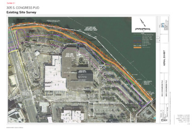
Existing Site Survey EXISTING HIKE AND BIKE TRAIL 1 / 8 Submitted: July 24, 2019Updated: June 26, 2020Updated: July 9, 2021Updated: April 14, 2021305 S. CONGRESS PUDCASE NUMBER: C814-89-0003.02Updated: October 12, 2020 Existing Zoning Map PUD-NP E U N E V S A S E R G N O H C T U O S T E E R T T S H 1S PUD-NP T U O S CS-1-V-NP P-NP B A R T O N S P R I N G S R O A D CS-1-V-NP CS-1-V-NP LI-NP CS-NP CS-1-NP W E S T R I V CS-1-V-NP E R S I D E D R I V E CS-V-NP L-NP 0 150’ 300’ 450’ 600’ Site Boundary (821,517 sf/18.86 acre) PUD-NP LADY BIRD LAKE P E 1ST STREET DRISKILL STEET DAVIS STREET CBD CBD T E E R T Y S AIN E R RIVER STREET 2 / 8 Submitted: July 24, 2019Updated: June 26, 2020Updated: July 9, 2021Updated: April 14, 2021305 S. CONGRESS PUDCASE NUMBER: C814-89-0003.02Updated: October 12, 2020 Property Boundary and Right of Way Map S O U T H C O N G R E S S A V E N U E B A RT O N S P RIN G S R O A D 0 100’ 200’ 300’ Site Boundary (821,517 sf/18.86 acre) Area 2: Future Barton Springs R.O.W. (85,816 sf/1.97 acre) BOUNDARY LINE ESTABLISHED BETWEEN CITY OF AUSTIN AND MILLER AND TRUSTEE VOL. 2221, PG. 69 VOL. 4297, PG. 439 VOL. 4439, PG. 1203 VOL. 4435, PG. 1744 APPROXIMATE LOCATION OF SHORELINE 429’ ELEVATION LADY BIRD LAKE 3 / 8 Submitted: July 24, 2019Updated: June 26, 2020Updated: July 9, 2021Updated: April 14, 2021305 S. CONGRESS PUDCASE NUMBER: C814-89-0003.02Updated: October 12, 2020 Barton Springs Rd PUD Congress Avenue Barton Springs Rd PUD Street Sections and Internal Private Driveway Typical Sections A A’ E’ E C B’ B D’ C’ D C C’ STREET SECTION A-A’ SOUTH CONGRESS AVENUE EDGE CONDITION INTERNAL PVT DRIVEWAY SECTION C-C’ ENTRY STREET TYPICAL SECTION 66' WIDE i e n L y t r e p o r P 66' 56' 11' 67' e n i l b r u C s e n i l b r u C Active Ground Floor Active Ground Floor Active Ground Floor 30' PEDESTRIAN + LANDSCAPE PEDESTRIAN VEHICULAR LANE EXISTING BIKE LANE SOUTH CONGRESS AVENUE 11' 7' 14' 10' 10' 10' 10' 10' 7' 14' 11' 8' 11' PEDESTRIAN LANDSCAPE/ DROP OFF 18' 30' 48' 18' LANDSCAPE/ DROP OFF PEDESTRIAN STREET SECTION B-B’ BARTON SPRINGS AVENUE TYPICAL SECTION 56' WIDE INTERNAL PVT DRIVEWAY SECTION D-D’ SHARED STREET TYPICAL SECTION 66' WIDE 67' 56' 305 S Congress Avenue Property 11' Easement s e n i l b r u C s e n i l b r u C 66' e n i l b r u C e n i l b r s u e C n b r u C i l e n i l b r u C 30' EXISTING PEDESTRIAN VEHICULAR LANE 14' 10' 10' 14' 8' 11' SOUTH CONGRESS AVENUE FUTURE SIDEWALK FUTURE LANDSCAPE LANDSCAPE /DROP OFF SIDEWALK EASEMENT SHARED LANE SHARED LANE 48' CURB-TO-CURB 11' 7' 10' 10' 10' 7' 11' PEDESTRIAN LANDSCAPE BIKE/PEDESTRIAN ZONE LANDSCAPE PEDESTRIAN 18' 30' 18' SHARED ZONE PEDESTRIAN + TRAFFIC LANES Active Ground Floor Active Ground Floor PEDESTRIAN WALKWAY TYPICAL SECTION E-E’ 45' WIDE Rooftop Congress Avenue Barton Springs Rd PUD Rooftop Active Ground Floor Active Ground Floor 12' 25' 8' CAFE ZONE SIGNATURE WALK (FIRE LANE ACCESS) CAFE ZONE 45' 4 / 8 Submitted: July 24, 2019Updated: June 26, 2020Updated: July 9, 2021Updated: April 14, 2021305 S. CONGRESS PUDCASE NUMBER: C814-89-0003.02Updated: October 12, 2020BARTON SPRINGS ROAD SOUTH CONGRESS AVENUE DRIVEWAY BDRIVEWAY ADRIVEWAY C Setbacks and Land Use Map 25 YEAR FLOODPLAIN LINE 432.57’ ELEVATION ACCORDING TO COA RAS MODEL HALF CRITICAL WATER QUALITY ZONE SETBACK LINE 50’ FROM SHORELINE CRITICAL WATER QUALITY ZONE SETBACK LINE 100’ FROM SHORELINE PRIMARY SETBACK LINE 90’-150’ FROM SHORELINE ’ 0 5 1 ’ 0 5 1 ’ 0 5 90’ APPROXIMATE LOCATION OF SHORELINE 429’ ELEVATION AREA 1 AREA 2 AREA 1 AREA 2 INCLUDE PARK LAND INUNDATED LAND BARTON SPRING EXTENSION INTERNAL PRIVATE DRIVEWAYS PLAZA/LANDSCAPE AREAS DEVELOPABLE PARCELS S O U T H C O N G R E S S A V E N U E PRIVATE DRIVE: MINIMUM 170' DISTANCE FROM BARTON SPRINGS INTERSECTION B A RT O N S P RIN G S R O A D 0 100’ 200’ 300’ 150’ 50’ 100 YEAR FLOODPLAIN LINE 440.88’ ELEVATION ACCORDING TO COA RAS MODEL PRIMARY SETBACK LINE 150’ FROM SHORELINE SECONDARY SETBACK LINE 50’ FROM PRIMARY SETBACK LINE 15 0’ LADY BIRD LAKE POTENTIAL FUTURE CAPMETRO STATION Site Boundary (821,517 sf/18.86 acre) Area 2: Future Barton Springs R.O.W. (85,816 sf/1.97 acre) Area 2: Developable Parcel (305,688 sf/7.02 acre) Area 1: Park Land (284,418sf/6.53 acre, which includes the inundated land.) Area 1: Inundated Land (24,342 sf / 0.56 acres) Area 2: Internal Private Driveway (76,117 sf/1.75 acre) Area 2: Plaza/Landscape Area (69,478 sf/1.59 acre) 5 / 8 Submitted: July 24, 2019Updated: June 26, 2020Updated: July 9, 2021Updated: April 14, 2021305 S. CONGRESS PUDCASE NUMBER: C814-89-0003.02Updated: October 12, 2020 WATER QUALITY FEATURE 25 YEAR FLOODPLAIN LINE 432.57’ ELEVATION ACCORDING TO COA RAS MODEL GREAT LAWN PIER . X A M " 0 - ' 0 7 35''-0" MAX. WATER STEPS 30'-0" MAX. 40'-0" MAX. CRITICAL WATER QUALITY ZONE SETBACK LINE 100’ FROM SHORELINE HALF CRITICAL WATER QUALITY ZONE SETBACK LINE 50’ FROM SHORELINE WATER QUALITY FEATURE 6 75'-0" M A X. 70'-0" X. A M BOARDWALK WATER STEPS CONCEPTUAL DETAIL GREAT STEPS MULTI-USE TRAIL PLAY AREA LADY BIRD LAKE WATER QUALITY FEATURE 100 YEAR FLOODPLAIN LINE 440.88’ ELEVATION ACCORDING TO COA RAS MODEL PRIMARY SETBACK LINE 150’ FROM SHORELINE SECONDARY SETBACK LINE 50’ FROM PRIMARY SETBACK LINE PROPOSED FUTURE PROJECT CONNECT RAIL LINE AND/OR STA- TION Conceptual Open Space Map S O U T H C O N G R E S S A V E N U E NOTES: 1. The location and size of all improvements shown on this Exhibit are approximate and subject to change based upon final design. 2. Location and size of improvements shown on the plan may be modified and approved administratively by city staff, so long as such modification is in accordance with Section 3.1.3. Such modification must be approved by the Parks Department and Watershed Protection. 3. The average width of the trail will be up to 15 feet. In conjunction with the Environmental Protection and Restoration Plan, shoreline improvements include the removal of all non-native, invasive species and the following native trees: Tag # Species DBH (in.) 1086 1087 1396 1397 1402 1414 1450 Sycamore American Elm Sycamore American Elm American Elm Pecan American Elm 16 10 10 11 8 19 14 Note: This table does not represent a comprehensive list of trees located within the PUD that will be affected by the redevelopment of the Property. B A RT O N S P RIN G S R O A D 0 100’ 200’ 300’ Site Boundary (821,517 sf/18.86 acre) Plaza/Landscape Area (69,478 sf/1.59 acre) Park Land (284,418sf/6.53 acre, which includes the inundated land.) *PARKLAND AREA IS SUBJECT TO CHANGE BASED ON FINAL LOCATION AND DESIGN OF CAPMETRO STATION 6 / 8 Submitted: July 24, 2019Updated: June 26, 2020Updated: July 9, 2021Updated: April 14, 2021305 S. CONGRESS PUDCASE NUMBER: C814-89-0003.02Updated: October 12, 2020 305 S. CONGRESS PUD Environmental Protection and Restoration Plan Environmental Protection and Restoration Plan BUTLER HIKE AND BIKE TRAIL PIER FOR BAT VIEWING 305 S. CONGRESS PUD Environmental Protection and Restoration Plan HALF CRITICAL WATER QUALITY ZONE (50' FROM SHORELINE) CRITICAL WATER QUALITY ZONE (100' FROM SHORELINE) PIER FOR BAT VIEWING BUTLER HIKE AND BIKE TRAIL FORMAL WATER ACCESS TO REDUCE TRAMPLING* FORMAL WATER ACCESS TO REDUCE TRAMPLING* BOARDWALK FOR BAT VIEWING HALF CRITICAL WATER QUALITY ZONE (50' FROM SHORELINE) CRITICAL WATER QUALITY LADY BIRD LAKE ZONE (100' FROM SHORELINE) SHORELINE (429') BOARDWALK FOR BAT VIEWING LADY BIRD LAKE 100 YEAR FLOOD SHORELINE (429') (440.88' - COA RAS MODEL) L L a a d d y Bir y Bir L L a a d d 100 YEAR FLOOD (440.88' - COA RAS MODEL) ENVIRONMENTAL PROTECTION* ENVIRONMENTAL PROTECTION* d L d L y Bir y Bir a a e e k k d L d L a a k k e e 0 100 ft 0 100 ft ENVIRONMENTAL PROTECTION AND RESTORATION ELEMENTS Herbaceous Riparian GSI with Pollinator and Prairie Plants Floodplain Forest * final location determined during site plan process Study Area Environmental Protection* Wetland Fringe ENVIRONMENTAL PROTECTION AND RESTORATION ELEMENTS Herbaceous Riparian GSI with Pollinator and Prairie Plants Floodplain Forest * final location determined during site plan process CASE NUMBER C814-89-003.02 Study Area Environmental Protection* Wetland Fringe CASE NUMBER C814-89-003.02 2. Bat conservation: Notes: 1. Environmental protection and enhanced cultural experience: A major threat to environmental superiority of the site is the regular degradation of areas due to heavy use of the property by the public to view the bats and access the water. To accommodate additional park users, reduce trampling of restored areas, create additional bat viewing areas, and improve the views of Lady Bird Lake and the downtown Austin skyline, this project proposes to construct a pier; a boardwalk, and one hardened water access point. By directing users to these landscape features, other parts of the open space can be protected, restored, and maintained to create an environmentally superior site. Please refer to the Open Space Map for maximum shoreline amenity dimensions. Notes: 1. Environmental protection and enhanced cultural experience: A major threat to environmental superiority of the site is the regular degradation of areas due to heavy use of the property by the public to view the bats and access the 2. Bat conservation: water. To accommodate additional park users, reduce trampling of restored areas, create additional bat viewing areas, and improve the views of Lady Bird Lake and the downtown Austin skyline, this project proposes to construct a pier; a boardwalk, and one hardened water access point. By directing users to these landscape features, other parts of the open space can be protected, restored, and maintained to create an environmentally superior site. Please refer to the Open Space Map for maximum shoreline amenity dimensions. The project will protect the Austin Bat Colony by using dark sky compliant lighting within 75’ of the shoreline, creating safe vantages for bat viewing that do not disturb bat behavior, maintaining the bald cypress fringe along the shoreline critical for bat navigation, and maintaining an area free of trees directly east of the Congress Avenue Bridge at the lakeshore for bats to congregate before flight. The applicant will also continue to coordinate with local bat conservation groups for best practices during the design and construction phases of the project. 3. Protect critical environmental features, floodplain forest, and The project will protect the Austin Bat Colony by using dark sky compliant lighting within 75’ of the shoreline, creating safe vantages for bat viewing that do not disturb bat behavior, maintaining the bald cypress fringe along the shoreline critical for bat wetland plantings: navigation, and maintaining an area free of trees directly east of the Congress Avenue Existing slope and superior tree preservation commitments do not make it feasible to Bridge at the lakeshore for bats to congregate before flight. The applicant will also continue to coordinate with local bat conservation groups for best practices during move the trail from its current alignment; barriers will be used to protect the wetland the design and construction phases of the project. fringe and floodplain forest. A combination of split rail fence, cable fence, boulders, and/or equivalent will be used adjacent to the trail and access points to direct users and will include at least 800 linear feet of protection. 3. Protect critical environmental features, floodplain forest, and wetland plantings: Existing slope and superior tree preservation commitments do not make it feasible to move the trail from its current alignment; barriers will be used to protect the wetland fringe and floodplain forest. A combination of split rail fence, cable fence, boulders, and/or equivalent will be used adjacent to the trail and access points to direct users and will include at least 800 linear feet of protection. 4. Restore floodplain forest: Restore at least 1 acre of riparian woodland forest between the water edge and the trail. Restoration includes the invasive species removal (Ligustrum, Nandina, Chinaberry, Chinese tallow, Arundo, Japanese honeysuckle, lacebark elm, tree of heaven, English Ivy, Asian Jasmine, Vitex, and poison ivy along with other invasives will occupy no more to less than 5% vegetative cover), temporary irrigation, soil amendments where needed (up to 3” of native compost gently raked into upper surface), planting 500 native herbaceous and ground cover plants (1 gallon) planted in clumps 18" on center, as well as seeding 28 pounds of native riparian seed. Restore at least 1 acre of riparian woodland forest between the water edge and the trail. Restoration includes the invasive species removal (Ligustrum, Nandina, Chinaberry, Chinese tallow, Arundo, Japanese honeysuckle, lacebark elm, tree of heaven, English Ivy, Asian Jasmine, Vitex, and poison ivy along with other invasives will occupy no more to less than 5% vegetative cover), temporary irrigation, soil amendments where needed (up to 3” of native compost gently raked into upper surface), planting 500 native herbaceous and ground cover plants (1 gallon) planted in clumps 18" on center, as well as seeding 28 pounds of native riparian seed. 4. Restore floodplain forest: 5. Restore and enhance the wetland fringe: 5. Restore and enhance the wetland fringe: The wetland fringe is shaded out by invasive understory and is trampled in numerous areas. Restoration of the 1,000 square feet of wetland fringe will entail the removal of invasive species as described above in note 4 and begin the establishment of wetland plants where feasible with a total planting of at least 15 obligate and facultative wetland species, planting at least 200 one gallon containers in up to 10 clumps. The wetland fringe is shaded out by invasive understory and is trampled in numerous areas. Restoration of the 1,000 square feet of wetland fringe will entail the removal of invasive species as described above in note 4 and begin the establishment of wetland plants where feasible with a total planting of at least 15 obligate and facultative wetland species, planting at least 200 one gallon containers in up to 10 clumps. 6. Restore riparian herbaceous vegetation: 6. Restore riparian herbaceous vegetation: At least 800 square feet of herbaceous riparian vegetation will be planted adjacent to At least 800 square feet of herbaceous riparian vegetation will be planted adjacent to Congress Avenue Bridge between the trail and the lake to keep the area open for the Congress Avenue Bridge between the trail and the lake to keep the area open for the bats and to add plant diversity. The planting will include at least 300 plants (1 gallon) planted in clumps 18" on center to reduce weeds and will include physical barriers to bats and to add plant diversity. The planting will include at least 300 plants (1 gallon) help minimize trampling. Preparation of the area will include woody species removal, planted in clumps 18" on center to reduce weeds and will include physical barriers to invasive species removal, soil amendments as necessary, and temporary irrigation help minimize trampling. Preparation of the area will include woody species removal, installation. invasive species removal, soil amendments as necessary, and temporary irrigation 7. Pollinator plants: installation. The project will include at least 30 native pollinator and prairie species (both planted and seeded) in green stormwater infrastructure that covers approximately 1-acre of the site. 7. Pollinator plants: 8. Sustainable management plan: 8. Sustainable management plan: The project will include at least 30 native pollinator and prairie species (both planted and seeded) in green stormwater infrastructure that covers approximately 1-acre of the site. The applicant is committed to creating a sustainable land management plan for the site in coordination with appropriate entities that could include the Trail Foundation, bat conservation organizations, South Central Waterfront entities, and others. The plan will use an adaptive management framework that focuses on an enhanced user experience and ecological functionality that results in long-term, sustainable management of the site. At a minimum, the land management plan will include bi-annual management of invasive species (as listed above), increases in diversity through planting and seeding, ensuring native vegetative cover, and annual monitoring. The applicant is committed to creating a sustainable land management plan for the site in coordination with appropriate entities that could include the Trail Foundation, bat conservation organizations, South Central Waterfront entities, and others. The plan will use an adaptive management framework that focuses on an enhanced user experience and ecological functionality that results in long-term, sustainable management of the site. At a minimum, the land management plan will include bi-annual management of invasive species (as listed above), increases in diversity through planting and seeding, ensuring native vegetative cover, and annual monitoring. 8/8 7 / 8 8/8 Submitted: July 24, 2019Updated: June 26, 2020Updated: July 9, 2021Updated: April 14, 2021305 S. CONGRESS PUDCASE NUMBER: C814-89-0003.02Updated: October 12, 2020South CongreSSSouth CongreSSSouth CongreSSSouth CongreSS Data Table and Notes Total Site Area Minimum Lot Size Minimum Lot Width Maximum Height Maximum Impervious Cover * Maximum Building Coverage Maximum Floor Area Ratio * Minimum Setbacks 5,750 sf 50 feet 525 feet 68% 55% 4.3 : 1 0 feet 0 feet 0 feet 0 feet Front Yard Street Side Yard Interior Side Yard Rear Yard NOTES: 1. The maximum height of any structure within Area 2 shall not exceed 525 feet from finished grade. Exceptions from the maximum height limit under 25-2-531 shall apply. 2. The maximum height of any structure within Area 1 shall not exceed 35 feet from finished grade. Exceptions from the maximum height limit under 25-2-531 shall apply. In addition to the uses described in Section 25-2-721(B)(2) the following are additional uses that are permitted within the primary setback area: charging stations, bike/scooter repair facilities, shared bicycle facilities, restrooms facilities with or without showers, temporary or mobile food and beverage vendors, bike valet, temporary or mobile music vendors, temporary or mobile retail vendors, boat rentals, bicycle rentals, temporary or mobile performance and special events facilities, exercise courses, sports equipment rentals, storm water facilities, and child playscapes / activities. In addition to the uses described in Note 3, the following are additional uses permitted within Area 1: • Automotive Sales (limited only to bicycle and scooter sales) • Automotive Rentals (limited only to bicycle and scooter rentals) • Automotive Repair Services (limited only to bicycle and scooter repair services) Indoor Entertainment Indoor Sports/Recreation • • • Personal Improvement Services • Personal Services • Pet Services • Recreation and Equipment Sales • Theater • Transportation Terminal • Temporary Uses Described in Section 25-2-921 3. 4. 5. Indoor Entertainment Indoor Sports/Recreation In addition to the uses described in Section 25-2-691, the following are additional pedestrian oriented uses allowed in Area 2: • Administrative and Business Offices • Automotive Sales • Automotive Rentals • Automotive Repair Services • Financial Services • Hotel – Motel • • • Medical Offices – exceeding 5,000 sq. ft. gross floor area • Medical Office – not exceeding 5,000 sq. ft. gross floor area • Personal Improvement Services • Personal Services • Pet Services • Professional Office • Recreation and Equipment Sales • Theater • Transportation Terminal • Temporary Uses Described in Section 25-2-921 • Veterinary Service 6. The following uses are permitted uses within Area 2: • Bed & Breakfast (Group 1) • Bed & Breakfast (Group 2) • Condominium Residential • Multifamily Residential • Townhouse Residential • Short-Term Rental (Types 1 and 3) • Administrative and Business Office • Art Gallery • Art Work Shop • Automotive Sales • Automotive Rentals • Automotive Repair Services • Business or Trade School • Business Support Services • Cocktail Lounge • Commercial Off-Street Parking • Communications Services • Consumer Convenience Services 821,517 sf / 18.858 acres Breakdown Total Acres Total GSF Percentage Land Use Summary Future Barton Springs Road Extension Internal Private Driveways Public Realm Park Land ** Plaza / Landscape Area R.O.W. Open Space Total Public Realm Area Development Parcel Total Developable Area Developable Land Total Land Area ** Park Land includes inundated land totaling 0.56 acres / 24,342 sf 1.97 1.75 6.53 1.59 11.84 7.02 7.02 18.86 85,816 76,117 284,418 69,478 515,829 305,688 305,688 821,517 10.5% 9.3% 34.6% 8.4% 62.8% 37.2% 37.2% 100% Residential Hotel Commercial Office 1,378 units 275 keys 150,000 gsf 1,500,000 gsf Land use and intensities may change so long as development subject to the PUD adheres to the limitations outlined in the TIA dated July 2, 2021 * Impervious cover, building coverage, and floor-to-area is based on gross site area of all of the land within the PUD. * Impervious cover and building coverage will be higher on a parcel by parcel calculation. Indoor Entertainment Indoor Sports and Recreation • Consumer Repair Services • Convenience Storage • Electronic Prototype Assembly • Electronic Testing • Financial Services • Food Preparation • Food Sales • General Retail Sales (Convenience) • General Retail Sales (General) • Hotel-Motel • • • Kennels • Laundry Services • Liquor Sales • Marina • Medical Offices – exceeding 5,000 sq. ft. gross floor area • Medical Office – not exceeding 5,000 sq. ft. gross floor area • Off-Site Accessory Parking • Outdoor Entertainment • Outdoor Sports and Recreation • Pedicab Storage and Dispatch • Personal Improvements Services • Personal Services • Pet Services • Plant Nursery • Professional Office • Recreational Equipment Maint. & Stor. • Recreational Equipment Sales • Research Assembly Services • Research Services • Restaurant (General) • Restaurant (Limited) • Service Station • Stables • Software Development • Theater • Vehicle Storage • Veterinary Services • Custom Manufacturing • General Warehousing and Distribution • Light Manufacturing • Limited Warehousing and Distribution • Community Garden • • Urban Farm • Administrative Services • Camp • Club or Lodge • College and University Facilities • Communication Service Facilities • Community Events • Community Recreation (Private) • Community Recreation (Public) • Congregate Living • Convalescent Services • Counseling Services • Cultural Services • Day Care Services (Commercial) • Day Care Services (General) • Day Care Services (Limited) • Family Home • Group Home, Class I (General) • Group Home, Class I (Limited) • Group Home, Class II • Hospital Services (General) • Hospital Services (Limited) • Local Utility Services • Maintenance and Service Facilities • Park and Recreation Services (General) • Park and Recreation Services (Special) • Private Primary Educational Facilities • Private Secondary Educational Facilities • Public Primary Educational Facilities • Public Secondary Educational Facilities • Religious Assembly • Safety Services • Telecommunication Tower 7 • Transportation Terminal Indoor Crop Production 7. Parkland dedication shall be satisfied in accordance with the Open Space Map. onsite. 26. The project will participate in the Art in Public Places Program by incorporating 2 art pieces 8. The total buildable square footage is 4.3:1 FAR and will consist of the uses included in Notes 27. Reclaimed water will not be used for outdoor irrigation within the Critical Water Quality Zone 3, 4, 5, and 6. and 100-year floodplain areas. 9. A site can cross a public street or right-of-way. 10. A site plan for the construction of an amphitheater that is associated with a commercial, civic or residential use may be approved administratively. 28. The PUD proposes to reserve an area, as generally shown on the Land Use Plan and Open Space Map, for the development of a pedestrian and/or transit bridge and rail station, which will be constructed by others. This reservation will expire 15 years after the PUD approval date. of not less than four feet and at the time of site plan the applicant submits documentation that the discharge or impoundment of groundwater from the structure, if any, will be managed to avoid adverse effects on public health and safety, the environment, and adjacent property. Furthermore the parking structure may exceed 15% of the site. 46. Section 25-2-721(G) is modified so that loading and unloading shall be allowed from any internal driveway and not required to be screened from public view. Loading and unloading locations on private internal driveways are subject to TCM spacing and dimensional requirements subject to ATD approval. 47. Section 25-4-51 is modified such that a preliminary plan is not required for the extension of 11. Pedestrian oriented uses are permitted above the ground floor of a structure. 29. Typical spacing of street trees will be 30 feet on center. This is subject to constructability Barton Springs Road. due to location of utilities, loading docks, and entrances into the parking garage. 30. Water quality will meet or exceed requirements for each corresponding phase for the by ECM) within the 100-year floodplain. 48. Section 25-8-261(H)(4) is modified to allow green stormwater quality controls (as defined 12. Section 25-2-692(F) is modified to read: “Not less than 50 percent of the net usable space on the ground level within 50 feet of the exterior wall of a structure directly adjacent to and facing Lady Bird Lake must contain pedestrian oriented uses.” 13. Section 25-2-721 is modified to allow a maximum of 60% impervious cover within the secondary setback area. maximum reflectivity. Land Use Plan. 14. Section 25-2-721(E) is waived; however, all building glazing systems shall have a 35 percent 15. The primary setback line is reduced to 90 feet landward from the shoreline as shown on the 16. Section 25-2-742(D)(1) is modified to read “For a ground level wall that is visible from parkland or public right-of-way that adjoins parkland, at least 60 percent (exclusive of service areas, loading docks, and parking ramps) of the wall area that is between 2 and 10 feet above grade must be constructed of clear or lightly tinted glass. 17. Section 25-2-742 is modified to allow exposed architectural concrete to be approved as a natural building material. 18. Section 25-2-742(G)(3) and (4) does not apply to the Property. 19. Section 25-2-1176(A)(1) is modified to allow the construction of a pier to extend up to 70 feet from the shoreline. Section 25-2-1176(A)(4) is modified to allow for construction of the elements and dimensions shown on the Open Space Map. Environmental Criteria Manual Section 1.13.5(B)(3) (Recommended Guidance for Appropriate Method for Shoreline Stabilization and Modification) is modified to allow structural modification of the shoreline and associated steps as shown in the Open Space Map. The dimension of the water steps and bulkhead are not to exceed 100 linear feet of shoreline frontage and not to exceed 30 feet inland. Steps going into the water are allowed if in compliance with Section 25-2-1174 and the Environmental Criteria Manual 1.13 and LDC 25-8-368. 20. A site plan expires 8 years after the date of its approval, unless Section 25-5-81(B) 21. The minimum off-street parking, bicycle parking, and loading requirements shall be determined by the director subject to a Transportation Demand Management Plan approved as part of the PUD. 22. Impervious cover calculations exclude: (i) multi-use trails, open to the public and located on public land or in a public easement, (ii) areas with gravel placed over pervious surfaces that are used only for landscaping or by pedestrians and are not constructed with compacted base, (iii) porous pavement designed in accordance with the ECM, and (iv) sidewalks in a public right-of-way or public easement. 23. Development is allowed within the Critical Water Quality Zone that is in accordance with the PUD Land Use Plan and Open Space Map. This includes vegetative filter strips, rain gardens, bio-filtration ponds, stormwater outfall structures, park improvements including hard surface trails, bicycle trails, picnic facilities, playscapes, concessions including food and beverage vendors, bicycle rentals, sports equipment rentals, boat rentals, dining facilities, performance and special event facilities, boardwalks, sidewalks, pavilions, gazeboes, restrooms, exercise equipment and courses, water steps, boat landings, piers, rail station, and stream bank stabilization relative to the proposed steps. Construction of such facilities within the CWQZ shall not exceed a maximum of 24.5% impervious cover. 24. The construction of the water steps shall not be considered placement of fill within Lady Bird Lake. 25. All signage on the Property shall comply with the requirements of Section 25-10-129 (Downtown Sign District Regulations). development within the respective phase, provided that the existing sedimentation filtration pond may be used to achieve compliance temporarily until the permanent water quality controls for any phase are constructed and that all new controls added for any phase will be green stormwater controls. Upon completion of the development 100% of the water quality controls shall be green infrastructure as defined by the ECM. 31. Barton Springs Road extension shall be considered an Urban Roadway for purposes of complying with Chapter 25-2, Subchapter E – Design Standards and Mixed Use, and will be designed in accordance with the PUD street sections located on Sheet 4. 32. New site controls will be constructed to meet or exceed current requirements for the limits of construction of each phase and the impervious cover within the respective phase. 33. Chapter 25-2, Subchapter E – Design Standards and Mixed Use, Article 2.6 is modified so that loading and unloading shall be allowed from any internal driveway and not required to be screened from Congress Avenue and Barton Springs Road. 34. Chapter 25-2, Subchapter E – Design Standards and Mixed Use, Article 2.7 is modified so that compliance with Private Common Open Space and Pedestrian Amenity standards are satisfied based on the amount of public open space and parkland provided by the PUD. 35. Chapter 25-2, Subchapter E – Design Standards and Mixed Use, Article 2.8 is modified so that the area designated as a drop-off zone is excluded from the 50% calculation when determining the shaded sidewalk requirements. 36. Development of the Property is exempt from Chapter 25-2, Subchapter E – Design standards and Mixed Use, Article 2.2, Article 2.3, and Article 2.4. 37. If a license agreement is required for the stormwater quality controls in the right-of-way (Barton Springs Road or Congress Avenue) the city shall waive the annual fee associated with this improvement. 39. Section 25-6-451 is modified to allow joint use driveways between lots with recorded access easements that do not have frontage on a public right-of-way. 40. Section 25-6-532 is modified to allow shared loading and unloading spaces for the various uses within the PUD regardless of where the use or loading and unloading is located within the PUD. 41. TCM 1.3.1(B) is modified to allow a minimum horizontal radii of 150 feet for Barton Springs Road. 42. TCM 1.3.1(D)(2) is modified to allow a minimum approach tangent and intersection skew of 120° from Congress Avenue. 43. TCM 1.3.2 is modified to allow the construction of Barton Springs Road to adhere to the street cross-section within the PUD. 44. TCM Table 5-2 is modified to allow the construction of the driveways to adhere to the cross- sections within the PUD. 45. Section 25-8-63(C)(11) is modified so that a parking structure can be excluded from impervious cover calculations if it is below the finished grade of the land after it is constructed and is covered by soil with a minimum depth of two feet and an average depth subsections (C), (D), or (E) are met. 38. 25-6-381 is modified to allow access to Congress Avenue which is classified as a major roadway. 49. If feasible, the landowner will use raw water from Lady Bird Lake through a water contract with Lower Colorado River Authority as the source for all landscape irrigation. Potable or other sources shall only be used as backup supply if the primary sources are depleted. 50. Electrical easements shall be required for all developments. Their location and size on-site will be mutually determined at the subdivision plat/site plan submittal and may require more space than minimum building setback. 51. Bollards, or another similar type of barrier, will be used to close the Pedestrian Walkway, shown on Sheet 4 as Section E-E, from vehicular traffic. 52. Gated public right-of-way is prohibited. 53. 100% of the required on-site water quality volume will be treated with green stormwater infrastructure including, but not limited to, rain gardens, biofiltration ponds, and filter strips. Upon redevelopment of the Property, on-site green stormwater controls will be provided in the park to treat a minimum of 82,000 cubic feet of stormwater volume. 54. Section 25-8-367 is modified to allow relocation of earthen material for the water steps on Lady Bird Lake below the 435 foot contour without City Council approval. 55. Riparian restoration, including removal of invasive species, is allowed as long as it does not destabilize the shoreline and is done as part of a restoration plan submitted for review and approved by the Watershed Protection Department. 56. In addition to the uses described in Section 25-2-721(C)(1) the following are additional uses that are permitted within the secondary setback area: charging stations, bike/scooter repair facilities, shared bicycle facilities, restrooms facilities with or without showers, food and beverage vendors, bike valet, music vendors, retail vendors, boat rentals, bicycle rentals, performance and special events facilities, exercise courses, sports equipment rentals, storm water facilities, and child playscapes / activities. 57. Section 25-4-171 is modified to allow a lot in a subdivision not to abut a dedicated public street so long as the corresponding lot adjoins a private street or driveway. 8 / 8 Submitted: July 24, 2019Updated: June 26, 2020Updated: July 9, 2021Updated: April 14, 2021305 S. CONGRESS PUDCASE NUMBER: C814-89-0003.02Updated: October 12, 2020 305 S. Congress Avenue Sub Area Height Map Open Space C O N G R E S S A V E N U E Lady Bird Lake Sub Area 1 Maximum Building Height: 525’ Sub Area 2 Maximum Building Height: 485’ Sub Area 3 Maximum Building Height: 250’ S ub Area 1 Sub Area 2 S reaAub 3 BARTON SPRINGS ROAD 305 S. CONGRESS AVENUEMAY 25, 2021 COMMENT REVIEW REPORT UPDATE: 2 PHONE #: 512-974-1237 CASE NUMBER: C814-89-0003.02 CASE MANAGER: Kate Clark REVISION #: 02 PROJECT NAME: 305 S. Congress SUBMITTAL DATE: October 12, 2020 REPORT DUE DATE: November 6, 2020 FINAL REPORT DATE: November 30, 2020 REPORT LATE: 13 BUSINESS DAYS LOCATION: 305 South Congress Avenue STAFF REVIEW: This report includes all comments received to date concerning your planned unit development. The planned unit development will be approved when all requirements identified in this report have been addressed. However, until this happens, your planned unit development is considered disapproved. PLEASE NOTE: IF YOU HAVE ANY QUESTIONS, PROBLEMS, CONCERNS OR IF YOU REQUIRE ADDITIONAL INFORMATION ABOUT THIS REPORT, PLEASE DO NOT HESITATE TO CONTACT YOUR CASE MANAGER (referenced above) at the CITY OF AUSTIN, HOUSING AND PLANNING DEPARTMENT, 505 Barton Springs Road – 5th Floor, AUSTIN, TX 78704 REPORT: The attached report identifies those requirements that must be addressed by an update to your application in order to obtain approval. This report may also contain recommendations for you to consider, which are not requirements. ADDITIONAL REQUIREMENTS AND RECOMMENDATIONS MAY BE GENERATED AS A RESULT OF INFORMATION OR DESIGN CHANGES PROVIDED IN YOUR UPDATE. UPDATE DEADLINE: It is the responsibility of the applicant or his/her agent to update this planned unit development (PUD) amendment application. The Planning Commission must take an action no later than April 8, 2021 (estimated commission date) which is less than 181 days from the date of the previous action. Otherwise, the application will expire. Case Number: C814-89-0003.02 Comment Report Update 2 Art in Public Places – Susan Lambe – 512- 974-7852 AIPP 1. Please follow up directly with Susan Lambe at Susan.Lambe@austintexas.gov and copy Marjorie Flanagan at Marjorie.Flanagan@austintexas.gov to discuss the AIPP program and process. FYI: The ordinance will have to include an implementation process. Please coordinate with AIPP, Site Plan and Zoning Reviewers to begin developing initial language. Austin Energy Green Building – Sarah Talkington – 512-482-5393 AEGB 1. Generally, the 2-Star AEGB requirement is in line with expectations. FYI: The PUD should begin speaking with the Austin Energy District Cooling Team. Their contact information is: andrew.gallo@austinenergy.com and Sue.Arthur@austinenergy.com Update 1: Comment cleared. FYI: AEGB only rates whole buildings; the scope is comprehensive and there is no Core and Shell Only compliance path. It is the owners responsibility to ensure the tenants meet the AEGB rating requirements. This is typically achieved through a combination of lease requirements, tenant improvement budget, deposit and review by the owners rep. If this project is speculative, or will be occupied by multiple tenants, we recommend the project agrees to the 2-Star AEGB PUD commitment rather than 3-Stars. Austin Fire Department Planning – Laura Everett – 512-974-4134 We have no comments at this time. Update 0: Comment cleared. Austin Fire Review – Tom Migl – 512-974-0164 ADF 1. Please note for Barton Springs Road street sections with less than 25 feet of unobstructed width (void of parked cars or street scape), an Alternate Method of Compliance (AMOC) will be required to designate an operational area for ladder coverage on multistory buildings. Connectivity to Riverside Drive shall be maintained to facilitate two routes for first responder’s access and evacuation. Update 1: Comment cleared. 2 Case Number: C814-89-0003.02 Comment Report Update 2 ADF 2. Please verify uses allowed for “F&B” on next update. Update 1: Comment cleared. FYI: Signature Walk Section E-E has trees located within the 25 feet fire access. Please relocate out of fire access. Tree canopies will need to be maintained and trimmed to allow 14 feet of vertical clearance. AW Utility Review – Virginia Collier – 512-972-0117 WW 1. The Landowner shall use alternate water sources (AC condensate, foundation drain water, rainwater, stormwater etc.) as the primary water sources for all landscape irrigation within the 305 S. Congress PUD. Potable and/or reclaimed water shall only be used as a backup supply if the primary sources are depleted. Reclaimed water shall not be used for irrigation within water quality controls or other prohibited areas. PLEASE NOTE: This comment will need to be incorporated into the new ordinance. Update 1: Comment pending. Please follow up with AW Utility Reviewer directly to work out specific language to be included in the ordinance. Update 2: Comment pending. The following language needs to be incorporated in its entirety into the PUD ordinance. The Developer may use raw water from an existing contract with LCRA to serve as the primary water source for all landscape irrigation within the 305 S. Congress PUD. Alternative water sources (AC condensate, foundation drain water, rainwater, stormwater or reclaimed water) shall be used as the primary backup supply if the primary raw water source is depleted or unavailable. Reclaimed water shall not be used for irrigation within water quality controls or other prohibited areas. A completed version of Austin Water’s most current Water Balance Calculator tool must be submitted with any site development permit application within 305 S. Congress PUD to assess non-potable water demands and alternative water supplies for the development. WW 2. All buildings within the 305 S. Congress PUD shall be constructed using a dual distribution pipe system to supply non-potable fixtures within the buildings (including toilets/urinals and cooling towers among other approved fixtures) with the City’s reclaimed water service. Additionally, the 305 S. Congress PUD shall extend a 24” reclaimed water main across the Riverside – Barton Springs Intersection (point of connection to existing reclaimed system under construction), build an off-site reclaimed main from Riverside/Barton Springs to the development, and build internal distribution reclaimed mains to serve buildings within the 305 S. Congress PUD and to facilitate looping of distribution reclaimed mains to the south. PLEASE NOTE: This comment will need to be incorporated into the new ordinance. 3 Case Number: C814-89-0003.02 Comment Report Update 2 Update 1: Comment pending. Please follow up with AW Utility Reviewer directly to work out specific language to be included in the ordinance. Update 2: Comment pending. The following language needs to be incorporated in its entirety into the PUD ordinance. The Developer shall extend a 24” reclaimed water main across the Riverside – Barton Springs Intersection (point of connection to existing reclaimed system under construction), build an off-site reclaimed main from Riverside/Barton Springs to the development, and build internal distribution reclaimed mains to serve buildings within the 305 S. Congress PUD and to facilitate looping of distribution reclaimed mains to the south. Any site development permit application within the 305 S. Congress PUD will need to comply with the City’s mandatory connection requirements for commercial developments located in proximity to a reclaimed water distribution line. WW 3. All buildings within the 305 S. Congress PUD shall design distribution mains and private plumbing systems to accommodate domestic service pressures ranging from 105 to 120 PSI and a reclaimed service pressure of 125 to 140 PSI. Update 1: Comment cleared. WW 4. As discussed in the meeting on July 31, 2019, the landowner must obtain City approval of a Service Extension Request for water, reclaimed, and wastewater service. For more information pertaining to the Service Extension Request process and submittal requirements contact Alberto Ramirez with Austin Water, Utility Development Services at 625 E. 10th St., 7th floor, phone 512-972-0211. Austin Water reserves the right to make additional comments and to establish other requirements with the Service Extension Request review. Update 1: Comment cleared. FYI: Dedication of private streets and public utility easements does not obligate the City to approve the placement of City water and wastewater mains within same. Water and wastewater service shall be provided to each lot at their Right of Way frontage. City Arborist – Jim Dymkowski – 512-974-2772 FYI—ADDITIONAL COMMENTS MAY BE GENERATED WHEN THE REQUESTED INFORMATION HAS BEEN PROVIDED. CA 0. The current PUD development amendment proposes no code modifications to LDC SUBCHAPTER B. - TREE AND NATURAL AREA PROTECTION; ENDANGERED SPECIES. ARTICLE 1. - TREE AND NATURAL AREA PROTECTION. Update 1: Comment pending. With this update, the PUD now proposes to modify ECM Section 3.3.2 to provide that a tree survey is accurate for 10 years instead of 5 years. Staff is currently unable to support this request as previously shown, although phased development is proposed, it is 4 Case Number: C814-89-0003.02 Comment Report Update 2 currently centered on a significant portion of the site to be initially disturbed by the construction of underground parking, re-development of the detention and water quality for the site, and construction of the park/waterfront area along Lady Bird Lake. This would indicate that initial disturbance and development around the proposed preserved trees onsite would be completed within the standard shorter timeframe. Update 2: Comment cleared. CA 1. To achieve compliance with Tier 1 requirement 2.3.1 H, the PUD amendment would need to exceed the minimum landscape requirement. The PUD only proposes to meet or exceed the landscape requirement. Please clarify specifically how the PUD will meet or exceed the landscape requirement for tree plantings. Why is the amendment not proposing to meet this requirement (to exceed)? Please clarify how this might occur as the PUD is requesting a code modification to have 25-2 current landscape requirements not apply to the PUD. How this will affect tree planting onsite? Update 1: Comment pending. Response understood that additional information is still forthcoming for review. This delay or additional may affect the PUD land plan and development. Update 2: Comment pending. This comment was specific to exceeding the LS requirements within the PUD over current code as it relates to trees planted. The current comment response appears to be related to the plan for trees planted and preserved within the PUD with mention of the other Tier requirements not related to landscape requirements. For clarity staff believes that the following relate for some credit to satisfying this comment; • Street tree species diversity. Tree species for all streetscapes will be Appendix F streetscape Design Standards approved and at every block length tree species will change to limit monocultures and prevent urban forest destruction due to disease. Street trees will also be from the Appendix F list “Significant Shade Providers” • 100% of street trees will be from the ECM Appendix F Preferred Plant List - "Street Trees' (instead of 60%), will be no less than 10' tall (instead of 6' tall), and planted at 3" minimum caliper, 6" above grade (instead of 1.5" minimum caliper). No more than 25% of planted street trees will be from the same species, (instead of 50%). • At minimum, the PUD Street Trees will change species at every block length and have a minimum of five street tree species on site. Please clarify further if you disagree or wish to include additional landscape superiority items as they relate to trees. CA 2. The PUD proposes a code modification to Subchapter E to allow development in accordance with the PUD. Please clarify how this affects street tree planting options? If not complying with Subchapter E, how is the PUD proposing to be superior for street tree planting? The PUD exhibit for the street section of the new Barton Springs Extension currently proposes a smaller tree planting area than the ones envisioned by the South Central Waterfront (SCW) Plan. Update 1: Comment pending. Response understood that additional information is still forthcoming for review. This delay or additional may affect the PUD land plan and development. 5 Case Number: C814-89-0003.02 Comment Report Update 2 Update 2: Comment cleared. CA 3. In the PUD’s Section 2.4 Tier 2 requirements, the applicant’s response to the code requirement for planting with Central Texas seed stock is; “The PUD will meet or exceed the landscaping requirements”. Please clarify if the PUD will or will not be using this for superiority and if so, what this means for proposed tree planting. Update 1: Comment pending. Response understood that additional information is still forthcoming for review. This delay or additional may affect the PUD land plan and development. Update 2: Comment cleared. CA 4. In this same Tier 2 section, the PUD is not proposing to meet the heritage and protected tree preservation percentages as required for a PUD. For overall tree preservation within the PUD, staff requests that the PUD attempt to exceed, but at least commit to the following to meet the intent of the SCW Plan and the latest working draft of the regulating plan. Include the following requirements for tree preservation, street tree planting, and road and utility design and layout in the PUD. If the PUD will commit to exceeding these requirements, please describe how it will do so. Update 1: Comment pending. Response understood that additional information is still forthcoming for review. This delay or additional may affect the PUD land plan and development. Update 2: Comment pending revision to calculations and additional tree condition documentation to be provided to clarify any proposed removal of poor rated trees with the PUD. 1) Tree Protections: a) 100 percent of heritage trees shall be preserved, unless a tree is dead, fatally diseased, or poses an imminent hazard to life or property which cannot reasonably be mitigated without removing the tree. Heritage trees may be transplanted, if approved by the City Arborist. Transplanting is not considered removal. Update 1: Comment pending. Response understood that additional information is still forthcoming for review. This delay or additional may affect the PUD land plan and development. Update 2: Comment pending revision to calculations and additional tree condition documentation to be provided to clarify any proposed removal of poor rated trees with the PUD. b) The Landowner shall remove existing impervious cover and no new impervious cover shall be placed within the full critical root zone (CRZ) of Protected and Heritage Trees, except as follows: i) If more than 50% of the full critical root zone has impervious cover, a private certified arborist shall investigate the tree and root system condition. If determined by the investigation and concurred by the City Arborist the tree is in decline and removal of impervious cover is not a viable option or will not result in tree 6 Case Number: C814-89-0003.02 Comment Report Update 2 recovery, the tree can be removed. For Heritage Trees greater than 30 inches in diameter the land use commission variance process is required. All other Protected or Heritage trees shall be preserved. ii) Structures and access drives from a public street may be located within the outer half of the CRZ in compliance with ECM Section 3.5.2; iii) Internal drive aisles and surface parking may be located within the outer half of the CRZ in compliance with ECM Section 3.5.2 or within the inner half of the CRZ as long as at least 75% of the entire area of the full CRZ is free of impervious cover. Update 1: Comment pending. Response understood that additional information is still forthcoming for review. This delay or additional may affect the PUD land plan and development. Update 2: The comment response does not appear to address this issue in that it does not commit to at least these requirements. Please clarify how what is proposed as an alternative in the response is better than listed above? 2) Street Trees: on center. a) Street trees shall be planted along all streets at an average spacing not greater than 30 feet b) At least 1,000 cubic feet of soil volume shall be provided per tree. The City Arborist may approve a smaller soil volume if necessary due to utility conflicts or other unavoidable constraints; however, the project must meet the standards in the Environmental Criteria Manual (ECM). i) Overhead utilities shall be relocated underground to avoid any conflicts with the planting of shade trees. ii) All new utilities shall be located under the street, and with sufficient clearances to allow for the tree planting zone. Lateral lines may cross the planting zone. iii) Root barriers shall be introduced and located solely on the utility side, rather than creating boxes around the tree. Update 1: Comment pending. Response understood. Staff is not be able to support the current street tree planting proposed by the PUD at current code standards. The PUD would meet or exceed the proposed superiority for street trees as stated in the SCWD plan to account for soil volume and utility locations. Update 2: Comment pending. Other than the commitment to soil volume and possibly tree placement distance, the comment response on this issue appears to be in direct conflict to that provided in the code comparison chart – Trees, provided to this reviewer. Please clarify what the PUD is able to agree to and propose for street trees along with the utility placement issue. 7 Case Number: C814-89-0003.02 Comment Report Update 2 Drainage Engineering – David Marquez – 512-974-3389 DE 1. Completely fill out the superiority table. It is not clear what sections of code are being modified. Remove sections that will not be applicable such as the volumetric flood detention as I assume detention will not be provided due to the proximity of Lady Bird Lake. Update 1: Comment cleared. DE 2. As Karl mentioned in the meeting held on August 26, 2019, if there will be modifications in the language to allow development in the floodplain, we will need details about what modifications are being asked for. Drainage comments will remain open in case coordination is needed with the floodplain office. A few things to consider for my review are: structural certification when building in the floodplain including nonbuilding structures (see ASCE 24-14 Flood resistant design and construction), erosion and scouring, maintenance, ownership if constructing a boardwalk over water and open to the public. I’m not sure of the best avenue to address all items but in other reviews with larger entities there have been legal agreements that speak to many of these items above. Update 1: Comment pending. I’m leaving the comment open since the floodplain reviewer has the comment open, but it appears that LDC 25-7 is no longer being modified from what I can tell. She may want to language about administrative approval removed since there is already a process for administrative approval in the floodplain. Update 2: Comment cleared. Electric Review – Andrea Katz – 512-322-6957 EL 1. The following note needs to be added below the Land Use Map and Data Table: • “Electrical easements shall be required for all developments. Their location and size onsite will be determined at the subdivision plat/site plan submittal and may require more space than minimum building setback.” Update 1: Comment stands. This note needs to be added below the Land Use Map and Data Table on sheet 7. Update 2: Comment cleared. 8 Case Number: C814-89-0003.02 Comment Report Update 2 Environmental Officer – Chris Herrington and Atha Phillips – 512-974-2132 EO 1. Please provide a redlined copy of the existing PUD ordinance and all plan sheets. Update 1: Comment cleared. EO 2. Provide a code comparison table, similar to what is shown below that outlines Current Code, Current PUD entitlements, and Proposed PUD. The applicant can reach out for a copy of the spread sheet since below is only an example and does not include the chart. Update 1: Comment cleared. Current Code Acreage Use 138.19 land 6.467 water Commercial, MF, MU Water Quality ½” plus for 100% of site Current PUD (LA Watershed Ord.) 138.19 land 6.467 water Single Family None required (<20% impervious cover) Drainage Current code Current code No No 20% Net Site Area NSA=52.69 acres 20% = 10.54 acres plus 2 acres (Champion) LA regs tied to SF use per Ordinance IC based on slope* 16.92 acres + 1.23 acres = 18.15 acres plus 2 acres (Champion) Total =12.54 Total = 20.15 acres Floodplain Variance Impervious Cover Limits of Disturbance Proposed PUD Amendment 138.19 land 6.467 water Commercial, MF, MU 100% of water quality volume treated, 75% 75% of WQV treated by distributed green controls Current code Yes; 5,000 sq. ft. of structures proposed in floodplain 18.86 acres max plus 3 acres for road Total = 21.86 acres Reduction of 2 acres (Champion) Total = 21.86 acres (19.86 acres) 18.81 acres 30.2 acres 35.16 acres EO 3. Provide a copy of the Plat, the restrictive covenants, and an exhibit of existing easements outlined in Exhibit B #1, 2, 4, 6, 7, 8, 13, 15 with labels. If easements are to be modified with this amendment, provide a separate exhibit showing proposed easements. Update 1: Comment cleared. 9 Case Number: C814-89-0003.02 Comment Report Update 2 EO 4. Please provide an exhibit that captures the improvements planned for the Parkland/Open Space. Please contact us to set up a meeting about what would be expected on the exhibit. This sheet will become an exhibit within the PUD document. Update 1: Comment pending. Open Space exhibit provided does not match the exhibit or intent of the South Central Waterfront overlay plan. Add a note to the Open Space plan that states: “Improvements shown on the plan are conceptual and will be finalized at time of site plan.” Update 2: Comment cleared. EO 5. In the Superiority Table, Environmental Preservation, there is a comment about the eroded shoreline. Staff is unclear what the intention of this comment is, and the applicant needs to be very clear about what is proposed within the Parkland/Open Space areas. Please add all proposed construction to the Parkland/Open Space development. EO 6. Please add location of proposed landing of bridge across Lady Bird Lake. This location should take into consideration the large number of heritage and protected cypress trees along the lake’s edge. EO 7. In Exhibit A, Code Modifications, #23 asks to have Parkland/Open Space not count towards impervious cover. Please provide a total impervious cover allowance for the Parkland/Open Space on the exhibit requested in comment 4 and 5. Update 1: Comment cleared. Update 1: Comment cleared. Update 1: Comment cleared. EO 8. In Exhibit A, Code Modifications, #25 asks for fill in the lake and construction of a bulkhead. Please show this information on the exhibit requested in comment 4 and 5. Further comments are pending exhibit submittal. Update 1: See new comments. UPDATE 1 ADDITIONAL COMMENTS. EO 9. Note #13 states that the buildings will have a maximum reflectivity of 30% but the Audubon Society recommends a reflectivity of less than 15% to be effective. Update 2: Applicant has stated that they do not intend to meet this standard to avoid bird strikes. EO 10. Note #18 seeks to waive the requirements of the landscape code. Please provide an exhibit that outlines the alternative landscape proposed for the development. Update 2: Comment cleared; the applicant is not seeking any landscape code modifications. EO 11. Note #20 seeks to waive requirements of an allowable dock. Please remove this note, variances to code should be sought with the site plan. 10 Case Number: C814-89-0003.02 Comment Report Update 2 Update 2: A note was added stating that “Improvements shown on the plan are conceptual and will be finalized at time of site plan.” Since the improvements shown are conceptual and are allowed by code, any deviation from code should occur with the final design. EO 12. Please remove Note #23, since all floodplain requirements will be reviewed during the site plan review process. Update 2: Comment cleared; the applicant is not seeking any floodplain code modifications. EO 13. Remove Notes #24-26, development within the park will be determined at time of site plan. Update 2: A note was added stating that “Improvements shown on the plan are conceptual and will be finalized at time of site plan.” Since the improvements shown are conceptual and are allowed by code, any deviation from code should occur with the final design. EO 14. Note #32 states that the current WQ pond will be used until the permanent controls are built, please change the note to state that permanent water quality controls will be built with the first site plan. Update 2: Add a note that “Water quality ponds shown within the park are conceptual and will be designed and located at time of site plan.” EO 15. Notes #39, 40, and 41 state a specific amount of WQ volume will be treated. Remove these notes since the number could be more or less than the number stated or modify note to state that 100% of the stormwater captured will be treated by green storm water infrastructure which will include rain gardens, bio-filtration or filter strips. Update 2: We will need to discuss the note further. EO 16. The project is proposing water quality treatment within the right-of-way. Locating water quality treatment within the right-of-way is dependent upon future approvals, potentially including a license agreement. Add a note that the full amount of required water quality treatment volume will be provided on site if approvals for the use of right-of-way for water quality treatment are not obtained in the future. Update 2: We will need to discuss the note further and ROW water quality further. EO 17. Please provide information as to how the bat colony under Congress Bridge will be protected by the proposed development or provide the contact information of a bat expert who was consulted for the proposed development. Update 2: Comment cleared. TIER 1 EO 18. Open Space and Environmental Preservation: Superiority states that the proposed plan is meeting the intent of the SCWP but the proposed park and open space plan is not responding to site conditions or showing protections for existing wetlands or large trees on site. 11 Case Number: C814-89-0003.02 Comment Report Update 2 Update 2: A note was added stating that “Improvements shown on the plan are conceptual and will be finalized at time of site plan.” Since the improvements shown are conceptual, park design, water quality locations, and restoration will be decided at site plan. EO 19. Landscaping: Note #18 states that you are waiving this section of code but this table says that the PUD will meet or exceed landscape requirements. Please clarify for next submittal. Update 2: Comment cleared; applicant is not asking for any landscape code modifications. CODE MODIFICATIONS EO 20. Watershed staff does not support the following code modifications: • Waiving of the Landscape code 25-2, Article 9 Update 2: Comment cleared, as applicant is no longer requesting this modification. • 25-2-1174(B) • 25-2-1172(4) Update 2: See Response to EO 11. Update 2: See Response to EO 11. • 25-2-1176(A)(1)(4) and (9) Update 2: See Response to EO 11. • 25-8-65(C) Update 1: This is current code and modification is not necessary Update 2: Comment cleared, as applicant is no longer requesting this modification. • 25-8-63(C)(11) • 25-8-261 and 25-8-368 Update 1: This is current code and modification is not necessary. Update 2: Staff is willing to waive section 25-8-63(C)(11)(ii) and (iv) only Update 1: A park and appurtenances are allowed by code in open space. Exceptions to code should be handled at the site plan stage. EO 21. Note #44 to use the current pond until other controls are constructed is allowed but the new site Update 2: Update 2: See Response to EO 11. controls should be built with the first site plan. Update 2: We will need to discuss this further. 12 Case Number: C814-89-0003.02 Comment Report Update 2 UPDATE 2 NEW COMMENTS EO 22. Note # 10 of the PUD notes should be removed. Improvements shown on the plan are conceptual and will be finalized at time of site plan. Since the improvements shown are conceptual, park design, water quality locations, and restoration will be decided at site plan. EO 23. Note #19 is asking that the bulkhead not meet the standards in code that prevent erosion, staff does not support this request. EO 24. Note #25 is asking to waive the section of code that disallows fill in the lake and staff does not support this since the park layout is conceptual and all variances should be sought at time of site plan unless more specificity is provided. EO 25. Note #50 states that storm water controls will be allowed with 50’ of the shoreline, staff will only support this request if the trail will be moved away from the shoreline to prevent erosion. EO 26. Note #56 is attempting to modify 25-8-367 (Relocation of Shoreline Between Tom Miller Dam and Longhorn Dam) but the request is allowed by code and staff does not support this request. Environmental Review – Mike McDougal – 512-974-6380 EV1. Provide a redlined copy of the existing PUD ordinance and all plan sheets. Update 1: It will be necessary to determine the scope of the proposed amendment to the PUD. Provide a redline copy of the existing PUD ordinance and sheets. At minimum, demonstrate what is proposed to be removed from the PUD and also provide callouts summarizing: • Any proposed additions to PUD language and plans; • Locations of all proposed development in the CWQZ; and • Locations of all existing development within the CWQZ that will remain. Update 2: Comment cleared. EV2. Sheet 2 of the Superiority Table indicates efforts to provide for enhanced habitat for birds, mammals, amphibians, insects, and fish as well as bat conservation. Provide greater detail regarding these items. Update 1: Comment still stands. Update 2: Comment cleared. EV3. The applicant’s July 24th, 2019, cover letter indicates that the PUD amendment proposes to remove existing building, surface parking areas, and other impervious improvements from the 13 Case Number: C814-89-0003.02 Comment Report Update 2 CWQZ. Indicate the amount of impervious cover currently in the CWQZ, how much existing impervious cover will remain in the CWQZ, and the quantity / type of new development and impervious cover proposed in the CWQZ. Update 1: Comment cleared. Development within the CWQZ is proposed to be reduced from approximately 14.44% to approximately 5%. EV4. The proposed two way bike route on the Barton Springs extension will require east bound cyclists to cross the Barton Springs / Congress intersection diagonally or to use crosswalks. To provide for better continuity of bicycle traffic, provide a one-way 5 ½ foot bike lane on each side of the proposed Barton Springs extension. EV5. In addition to EV 04, transpose the landscape alignment and bike route alignment such that the bike route is adjacent to the vehicle lanes and the landscape is located between the bike route and pedestrian route. Update 1: Comment cleared. Update 1: Comment cleared. EV6. Provide the specific Code language intended to replace LDC 25-8-63(C)(11). The proposed change indicated in the comment response document does not appear to alter the soil depth requirement specified by Code nor any other requirements of this portion of Code. Update 2: For clarity, specify in item number 38 of the Code modification document that the parking structure must be covered by soil with a minimum depth of two feet and an average depth of not less than four feet in order to be considered pervious. EV7. Item Number 40 provided in the Code Modifications document modifies what type of construction is permitted in the CWQZ. However, the specific language provided in Item Number 40 would 14 Case Number: C814-89-0003.02 Comment Report Update 2 allow for any type of construction in the CWQZ: “…This includes, but is not limited to, vegetative filter strips, rain gardens…” Provide a thorough list of what uses are proposed to be permitted within the CWQZ and what uses will be prohibited within the CWQZ. Alternatively, at minimum provide a comprehensive list of what categories of uses would be prohibited in the CWQZ. The intent of this list of prohibited uses is to prevent uses in the CWQZ that would result in considerably reduced water quality (e.g., automotive repair, industrial use, etc). EV8. Per our recent meeting, demonstrate how the building design will reduce the potential for Update 2: Comment cleared. bird / building collisions. Floodplain Review – Katina Bohrer – 512-974-3558 Reviewer Notes: site is located on the southeast corner of South Congress and the Colorado River (the old Statesman site). Proposed PUD amendment includes a large swath of proposed parkland along the current hike and bike trail which currently fully encompasses the 100-yr floodplain. The 100-year floodplain ranges from 440.87 at the upstream end of the site to 440.51 at the downstream end, similarly, the 25-year ranges from 432.57 to 432.17. Per included plan sheets, the shore line elevation is 429. Because site is along the Colorado River, it is not impacted by proposed Atlas 14 floodplain regulations. See internal network folder for more information. FP1. Per letter provided by Armbrust & Brown, PLLC, the applicant proposes to alter the LDC and the International Building code to allow development within the 25-year and 100-year floodplains. Floodplain review does not agree to this proposed code alteration for the following reasons: a. It is unclear what is being provided in return which is superior to code as is required by PUD requirements. b. LDC Sections 25-7-93, 94, 95, and 96 all allow development within the floodplain therefore altering the LDC and the IBC to allow development within the floodplain is unnecessary. It is possible, however, that the applicant already has plans which have not been shared with this reviewer. Additional guidance or comments may be provided once additional clarification by the applicant has been supplied. Update 1: Comment still applies. Floodplain review does not agree to proposed code alteration to LDC 25-7 as LDC 25-7-92 outlines how development within the floodplain may be administratively approved. Floodplain office will not be able to approve development in the floodplain which does not meet these requirements or the requirements for exceptions as outlined in the sections mentioned above as anything outside that purview would be considered unsafe from flooding and only Council will be able to approve those variances. If proposed development meets the requirements as outlined in LDC 25-7-92C, then an administrative variance will be granted. 15 Case Number: C814-89-0003.02 Comment Report Update 2 a. Be aware that “floodplain modification variance” is different than “floodplain variance.” Floodplain modification is outlined in LDC 25-8-261 (environmental) and is managed via the environmental office (Chris Herrington) whereas floodplain regulations [i.e. safety] are outlined in LDC 25-7 sections 92-96 and is managed via the floodplain administrator (Kevin Shunk). A floodplain modification variance is primarily concerned about riparian connectivity and the natural and beneficial aspects of a floodplain while a floodplain variance is concerned about adverse impacts which impact the depth, duration, or frequency of flooding with direct potential impacts to the life and safety of people. b. Applicant is correct that current development shown on the site which is located within the floodplain could be leveraged to achieve No Adverse Impact, however, proposed development will still need to meet floodplain regulations at the time of site plan application, including either meeting requirements for exceptions of administrative variances as outlined in LDC 25- 7. If development does not meet these requirements, then a council variance from LDC 25-7 will be required UPDATE 2: All proposed changes to LDC 25-7 have been removed. Applicant has added (at update 1) a provision for site plans to have a life of 8 years (instead of 3). While the floodplain office is not necessarily enthusiastic about this proposed change, we understand why the applicant has requested it. Be aware that the Interagency Flood Risk Management Team (i.e. FEMA & the Corps of Engineers in conjunction with the Lower Colorado River Authority) is re-evaluating the Lower Colorado River Basin models to determine if they need to be updated in any form or fashion. The floodplain office does not necessarily expect any large changes in the floodplain extents through downtown Austin, nor do we expect any additional changes to the floodplain after this study is complete. Comment Cleared. FYI: Updated Atlas 14 floodplain regulations will not affect this site as it is adjacent to the Lady Bird Lake which is specifically being excluded from proposed code alterations. Applicant may learn more about Atlas 14 at http://austintexas.gov/atlas14 FYI: As the applicant does not propose to change code outside of allowances of development within the floodplain, other floodplain regulations are expected to be met (e.g. no adverse impact, structurally able to withstand flood forces, finished floor and safe access requirements, etc.). Floodplain regulations which are to be met will be whatever requirements are valid on the date of permit application. Housing HPD – Alex Radtke – 512-974-2108 HHPD 1: We would support and encourage the applicant to lease on an ongoing basis not less than 10% of total rental units developed in the PUD to households earning no more than 60% MFI for a period not less than 40 years from the date a final certificate of occupancy is issued, and 5% of total ownership units sold at an affordable price to income-eligible households earning no more than 80% MFI and resale restricted for a period not less than 99 years from the date a final certificate of occupancy is issued for the property as a way to demonstrate superiority of the proposed development. 16 Case Number: C814-89-0003.02 Comment Report Update 2 Update 1: Comment pending. The South Central Waterfront Vision Framework Plan is not an adopted regulatory plan. NHCD would prefer the applicant volunteer to follow the PUD ordinance requirements for exceeding baseline, which would include leasing on an ongoing basis not less than 10% of total rental units developed in the PUD to households earning no more than 60% MFI for a period not less than 40 years from the date a final certificate of occupancy is issued, and 5% of total ownership units sold at an affordable price to income-eligible households earning no more than 80% MFI and resale restricted for a period not less than 99 years from the date a final certificate of occupancy is issued. In addition, NHCD would support and encourage the applicant to pay a fee-in-lieu for the non-residential bonus square footage of the development. Update 2: Comment pending. HPD is in discussions with the applicant about adjusting affordability MFI levels to meet targeted levels. Office of Sustainability – Caitlin Admire – 512-974-9394 OOS 1. On your Superiority Table you list the Carbon Impact Statement (CIS) and opportunity to participate in a pilot program with the Office of Sustainability (OOS) as a “Project Specific Superiority Item”. Please complete the CIS worksheet provided by the case manager in order to allow us to see what strategies you may be intending to utilize. We see many promising elements already being mentioned in your application and the OOS welcomes the opportunity to discuss and work with you to implement sustainable strategies in this project. Update 1: Comment cleared. Thank you for providing the completed CIS form. We accept the score of 9 as shown. As the project progresses, we would be happy to meet and explore opportunities for the project to gain additional points – specifically for onsite renewable energy and/or food access. Provision of solar energy or district cooling (something we understand that has been brought up previously) could earn the renewable energy point. If there are future plans for the incorporation of a grocery store or community agriculture, we might also be able to accept that to earn the food point. OOS 2. We greatly support seeing the restoration and enhancement of wildlife habitat in landscaped areas throughout the project, and we encourage you to consider utilizing bird friendly architecture to minimize conflicts between your new buildings and the wildlife you will be fostering. Some good resources to get you started: a. Bird Friendly Building Design, by American Bird Conservancy https://3pktan2l5dp043gw5f49lvhc-wpengine.netdna-ssl.com/wp- content/uploads/2015/05/Bird-friendly-Building-Guide_LINKS.pdf b. Bird-Friendly Urban Design Guidelines by City of Calgary http://www.animalarchitecture.org/wp- content/uploads/2013/11/CalgaryBirdingGuidelines.pdf 17 Case Number: C814-89-0003.02 Comment Report Update 2 c. LEED Pilot Credit regarding Bird Collision Deterrence (Note, may be used for an AEGB pilot credit as well) https://www.usgbc.org/node/4561982?return=/pilotcredits/all/v4 Update 1: Comment cleared FYI: Per your response under EV2: “We are currently working on a plan that will address the type of habitat restoration that is proposed for this project. We will forward the information to staff as soon as it becomes available.” We would like a copy of the plan when it is available. PARD/Planning and Design Review – Scott Grantham PR 1. Please contact this reviewer to set up a meeting to go over the PUD amendment as it relates to current code, the existing PUD and South Central Waterfront Plan. Update 1: Please set up another meeting to revisit these topics. Update 2: We would request a joint follow up meeting with applicant, PARD, and Watershed staff. PR 2. Through this review process we will be discussing whether this project is superior to current code and adopted plans from the standpoint of parks. Update 1: Comment pending determination of superiority. Based on the adopted South Central Waterfront Plan, the baseline area of dedication shall be 9.6 acres. Park plan must meet or exceed this benchmark. a. Fully dedicated parkland (by deed) is expected for the majority of the area, and may receive up to 100% credit. Ponds, other water quality infrastructure, and floodplain may receive reduced credit, consistent with the Parkland Dedication Ordinance. b. Other public areas – Plazas, Secondary Setback, and Great Steps, must be recorded as Park Easements and receive partial credit. (This can also ensure that criteria in Parkland Dedication Operating Procedures concerning ROW visibility and access are met). These public areas are necessary to fulfill the acreage requirement in the South Central Waterfront Plan. c. Areas that are already dedicated parkland will receive 0% credit. d. Areas that are already park easements (e.g. Butler Hike and Bike Trail) may receive 50% credit if they are dedicated (by deed) as parkland. e. Size of ponds and water quality controls in the park appear large and will reduce usability of these areas. Minimize water quality treatments in parks by using green street strategies (shown in South Central Waterfront vision) and other innovative strategies (handling stormwater under structures). f. Please propose a plan for phasing and triggering of dedication. One possibility is that timing of dedication be tied to a certain percentage of buildout. PARD requires that public access be 18 Case Number: C814-89-0003.02 Comment Report Update 2 given to the waterfront park upon approval of the PUD, in the form of an easement; park to be later fully dedicated according to the phasing of construction. Update 2: Comment pending determination of superiority. Based on the adopted South Central Waterfront Plan, the baseline area of dedication shall be 9.6 acres. Park plan must meet or exceed this benchmark. A. Fully dedicated parkland (by deed) is required for the designated park area, and may receive up to 100% credit. Ponds, water quality facilities, floodplain, and inundated land (25 year floodplain) will receive reduced or no credit, consistent with the Parkland Dedication Ordinance. For the next update, prepare a table that shows a breakdown of the various types (e.g. 100 year FP 50%, 25 year 0%, Other encumbered land, generally 50%). B. Other public areas – Plazas and Great Steps, must be recorded as Park Easements and receive partial credit. (This can also ensure that criteria in Parkland Dedication Operating Procedures concerning ROW visibility and access are met). C. Consider inclusion of the area south of the Barton Springs extension as a Parkland Easement, considering this will be part of Crockett Square. D. The Butler Hike and Bike Trail is within a park easement, not yet fully deeded parkland; this area will receive 50% for inclusion within a deed. E. Per the SCW plan, ponds and water quality facilities will exist in parkland. As part of PUD superiority, create a cap on square footage of these facilities in parkland. F. For phasing and triggering of dedication, public access must be granted to the parkland areas as early as possible. The suggestion is to place these in a parkland easement, and dedicate in phases as site plans come in. A Parkland Improvement Agreement (with Programming and Maintenance) will be used to ensure that the parks can be built. G. Consider design modifications to the trail which will achieve superiority for both Watershed and PARD, moving a portion of the trail inland, incorporating rain gardens around the trail, and restoring the shoreline. 19 Case Number: C814-89-0003.02 Comment Report Update 2 PR 3. Part of superiority will be parkland dedication and parkland development fees to exceed current code and the existing PUD. Update 1: Comment pending determination of superiority. Please track proposed improvement cost (refer to City of Austin Parkland Amenity Guide), compared with development fee based on number of units. How will the park development be superior to current code, described in § 25-1- 606? Update 2: Consolidate with PR4. Comment cleared. PR 4. Calculations will be based on residential unit count. Current count is 1,378 units, and 275 hotel rooms. Please inform this reviewer if numbers have changed. Units certified as SMART Housing by the Neighborhood Housing and Community Development will not be counted in these calculations. Update 1: Comment pending determination of superiority. Thank you for information regarding unit count. Please update this reviewer if unit projection changes. The benchmark for PUD superiority for parkland dedication is 10.4 acres of parkland per 1,000 residents. Update 2: Comment pending. Part of superiority will be parkland dedication and parkland development fees to exceed current code and the existing PUD. Parkland dedication (land area) and park development (amount paid to construct amenities) will be calculated separately and used as metrics towards superiority. Calculate cost of amenities committed to be constructed as a spreadsheet exhibit and provide with the next update. PR 5. Thank you for providing a parks table on Sheet 7. Please break down this acreage in the following ways: 25-year floodplain, 100-year floodplain, area outside of floodplain, public parkland to be dedicated to the city, and private open space. Update 1: Thank you for providing figures – also shown on Sheet 7. Per the approved South Central Waterfront Plan, 9.6 acres is the baseline owed. Current proposed total is 7.58, including inundated land. Note that the deficit is approximately 2 acres credited, or 4 acres at 50%. Please add another column to table (or another table if this will be clearer) to indicate percentage of credit. Break out ponds and water quality infrastructure in parkland, which, if designed with PARD approval, may receive reduced credit. Break out Cap Metro Station area to receive reduced credit. To increase total, add in plazas, secondary setbacks, great steps, etc., which will be recorded with parkland easements, and credit these at 50%. Update 2: Per current code, all parkland is not equally usable for recreation (e.g. inundated land) and receives different amounts of credit. Please add another column to table (or another table if this will be clearer) to indicate percentage of credit. Break out ponds and water quality infrastructure in parkland, which, if designed with PARD approval, may receive reduced credit. To increase total, add in plazas, secondary setbacks, great steps, etc., which will be recorded with parkland easements, and credit these at 50%. PR 6. Note on Sheet 6 indicates that parkland areas can change based on Cap Metro station. Consider the sequence and how this might be accomplished. The challenge is to dedicate the parkland, and move towards superiority, while allowing some flexibility for the station. Ideally, the park will be designed to dovetail with a future station. 20 Case Number: C814-89-0003.02 Comment Report Update 2 Update 1: Thank you for your response. Because of the uncertainty of the rail station and whether this parkland could be built upon in the future, the PUD will need to contain a contingency regarding station construction, PARD approval of the station, and a deed or easement which expressly allows for the station use. In addition the contingency should include an additional PARD approved public amenity such as a Rail Plaza, either in the existing park or outside the park to the south, to offset the loss of parkland to the station. Acreage for station area will receive reduced parkland credit. Please outline station area, indicate acreage, and any additional rights for the line. Update 2: This area may be counted towards the park. The notes seem intended to reserve some rights to build the station here. However, there would not be any associated reserved rights. Please explain what is entailed in the potential future Capmetro station. If not addressed with this PUD amendment the station could require another PUD amendment in addition to a site plan, and Chapter 26 review. Remove Note #29, or substantially amend to state that these processes must be followed. PR 7. A Parkland Improvement Agreement with Maintenance will be required in conjunction with this PUD amendment. This reviewer will send a template. Update 1: Template has been sent. The parkland shall be maintained by the development or other entity, as approved by PARD, in the agreement. This agreement need not be completed for PUD approval. Rather, it will be required at time of dedication. Update 2: Template has been sent. The parkland shall be maintained by the development or other entity, as approved by PARD, in the agreement. This agreement need not be completed for PUD approval. Rather, it will be required at time of dedication OR if 2 step sequence is followed, at time of easements, assuming that land will be dedicated at site plan. PR 8. On an exhibit, please show existing elements - park and trail easements (hike and bike trail), contours, and trees. Update 1: Comment pending. Sheet 1 of the PARD exhibit shows all of these elements together which is difficult to read. Please separate into multiple exhibits. Please provide a full survey of the property, which shows ownership, and existing easements. Update 2: Comment pending. Survey has not yet been received. PR 9. On an exhibit, please show a detailed plan of the park which includes proposed locations for the boardwalk, pavilion, Great Lawn, and other elements referred to in the PUD Superiority Table (2.4 Tier Two PUD Requirements – Open Space). Update 1: Thank you for Open Space Map (Sheet 6). Identify location of pavilions, and any other planned elements not shown on this plan. Since the PUD will unlikely be able to meet the acreage requirements of 10.4 acres per 1,000 residents (see PR4), superiority will need to be made up in design and construction of a superior park system (and the remainder to be made up by fees in lieu of land at time of site plan). See PR 3 regarding park development superiority. Park development shall be consistent with the South Central Waterfront Vision Plan. 21 Case Number: C814-89-0003.02 Comment Report Update 2 Update 2: To help achieve the vision of the SCW plan, relocate the pond / raingarden from the Bat Observation Area to another location, and expand the Great Lawn area in this location. PR 10. Show and describe all trail connections from the park to the street network to the south (refer to page 46 of the South Central Waterfront Plan). Update 1: Comment pending. Please include and show trail connections from ROW endings, connecting to existing trail. Update 2: Comment cleared. PR 11. In the PUD Superiority Table, do any items coincide with the Bat Observation Theater described in the South Central Waterfront Plan (Pages 56 – 58)? Update 1: Comment pending more details on the step down from Congress Ave, and the bat observation area. Update 2: Comment cleared. Design work is shown in the SCW. Where the PUD is silent, it is assumed that the SCW will be followed. PR 12. Are there plans for a boat landing, such as the one described as Pontoon Landing in the South Central Waterfront Plan (page 59)? Update 1: Please confirm that the Pontoon Landing is the same as “Pier” on Sheet 6. Update 2: Comment cleared. Acknowledge that the bridge is called out as “Potential Future Bridge.” PR 13. From the applicant’s letter dated July 24, 2019, Exhibit A, Code Modifications the following are relevant to parks. These items should be discussed, so changes are offset by superior standards. • #7. Refers to 25-2-692 (F). Proposed modification is so that it only affects the side of the building that faces Lady Bird Lake. • #14. Refers to 25-2-742 (D)(1). Proposed modification is to exclude from transparency requirements, service areas, and loading docks. Update 1: PARD requests a full list of modifications from the South Central Waterfront plan – it appears that there are others (referred to on last page -notes 11, 13, 15, 25). PARD will need to account for all of these modifications in the equation of superiority. Update 2: Thank you for sending the list. It is understood that Area 1 is the Park, and that the Primary and Secondary Setbacks are both within Area 1. On Page 7, Notes 3 and 4 refer to Permitted Uses within the Primary and Secondary Setback Areas and Area 1. Further discussion and coordination are required between the Watershed and Housing and Planning Departments for these uses in Area 1. FYI More comments may be added as more details are made available. 22 Case Number: C814-89-0003.02 Comment Report Update 2 FYI When all comments are substantially addressed, this PUD amendment will be scheduled for Land, Facilities and Programs Committee, and for Parks Board. Update 2: Comment pending. Land, Facilities, and Programs Committee has been dissolved, and when comments are substantially addressed, PUD may be scheduled for Parks Board. Site Plan Review – Christine Barton-Holmes – 512-974-2788 ADMINISTRATIVE SP1. On Sheet 7 (Land Use Map and Data Table), please show your FAR as a ratio. SP2. Also on Sheet 7 in your Land Use Map and Data Table, add a column that shows percent of total Update 1: Comment cleared. for each land use listed. Update 1: Comment cleared. Update 1: Comment cleared. Update 1: Comment cleared. Update 1: Comment cleared. Update 1: Comment cleared. Update 1: Comment cleared. Waterfront, Waterfront Setbacks. Update 1: Comment cleared. SP3. Site plans will be required for any new development other than single-family or duplex residential. SP4. Any development which occurs in an SF-6 or less restrictive zoning district which is located 540 feet or less from property in an SF-5 or more restrictive zoning district will be subject to compatibility development regulations. SP5. Any new development is subject to Subchapter E. Design Standards and Mixed Use unless otherwise stated in the amendment and approved. SP6. Additional design regulations will be enforced at the time a site plan is submitted. SP7. The subject property is included in an approved site plan (SP-07-0070C) and a Neighborhood Plan Amendment Case (NPA-2019-0022.02) is under review. SP8. This site is subject to the following overlays on some portion of the site: Capitol View Corridors, SP9. This site is currently part of the South River City Neighborhood Planning Area. 23 Case Number: C814-89-0003.02 Comment Report Update 2 SCENIC ROADWAYS SP10. This site is within the Scenic Roadway Sign District. All signs must comply with Scenic Roadway Sign District regulations. Contact Cierra Flores at (512) 974-2612 for more information. Update 1: Comment cleared. Update 1: Comment cleared. DEMOLITION AND HISTORIC RESOURCES SP11. The applicant is responsible for requesting relocation and demolition permits once the site plan is approved. The City Historic Preservation Officer will review all proposed building demolitions and relocations prior to site plan approval. If a building meets city historic criteria, the Historic Landmark Commission may initiate a historic zoning case on the property. Update 1: Comment cleared. RESIDENTIAL DESIGN STANDARDS OVERLAY SP12. The site is subject to 25-2 Subchapter F. Residential Design and Compatibility Standards unless stated otherwise in the amendment and approved. Update 1: Comment cleared. SP13. Code Modification #11: Please clarify the requested relief from screening of loading areas. Is the intent that loading shall be wholly within buildings? And are internal roadways intended to be dedicated as public rights-of-way? Update 2: Please clarify if any physical screening will be provided or if the loading/unloading will be within the buildings wholly or partially. SP14. Please clarify if any shading for drop-off zones is intended. Shading requirements under 2.8 are a response to Austin’s climate, and some form of shade should be provided for drop-off zones as they are areas where people typically wait. Update 2: Comment cleared. Subdivision Review – Steve Hopkins – 512-974-3175 SR 1. The site appears to be platted with whole legal lots, if this is not correct please contact this reviewer. No further comments. Update 0: Comment cleared. ATD Transportation Engineering – Bryan Golden – 512-974-9183 24 Case Number: C814-89-0003.02 Comment Report Update 2 GENERAL PUD COMMENTS ATD 1. A Traffic Impact Analysis is required and has not been submitted. In addition, TIA review fees have not been paid. LDC, 25-6-113. Please submit the required TIA for review by the Austin Transportation Dept. Additional right-of-way, participation in roadway improvements, traffic signals, or limitations on development intensity may be recommended based on the review of the TIA. LDC 25-6-142. Update 1: Comment pending. A TIA was submitted and is currently being reviewed. Update 2: Comment pending 2nd submittal and review of TIA. ATD 2. All PUDs must provide for appropriate transportation and mass transit connections to areas adjacent to the PUD district and mitigation of adverse cumulative transportation impacts with sidewalks, trails, and roadways. Detailed comments will be provided through the traffic impact analysis. Update 2: Comment cleared. ATD 3. All PUDs must prohibit gated roadways. Update 2: Comment cleared. ATD 4. PUD must provide publicly accessible multi-use trail and greenway along creeks or waterway. Additional comments may be issued pending internal review by the Public Works Department. Update 2: Comment cleared. STREET SECTION COMMENTS ATD 5. Street Section A-A: No bike facility is shown in this cross section. The South Central Waterfront plan calls for a 6’-6.5’ raised bike lane behind a 2’ buffer along the east frontage of S. Congress. The ASMP identifies protected bicycle facility along Congress frontage as well. In order to meet the superior results expected from PUDs, the cross sections should at least meet the baseline set by ASMP. Update 2: The recently installed protected bike lanes must still be included within the cross section. PUD A-A cross section should mirror South Central Waterfront Plan for S. Congress (Core Transit Corridor): 25 Case Number: C814-89-0003.02 Comment Report Update 2 ATD 6. Street Section C-C: ASMP calls for this to be a 2-lane street with all ages and abilities bike infrastructure. If this is planned to be a street with low volume (less than 3000 ADT), national best practice would make a simple 5' painted bike lane in each direction acceptable for this facility, which would fit within the roadway width indicated in the cross section. If higher vehicular volume is planned, a protected bicycle lane would be necessary to be an all ages and abilities facility. Update 2: If 5000+ VTD are anticipated, protected bike lanes are required. The South Central Waterfront Plan requires min. 5’ bike lanes (see “Local Street” cross section from SCWP below): ATD 7. Street Section D-D: ASMP calls for this to be a 2-lane street with all ages and abilities bike infrastructure. If the space shown in the cross section is intended as a two-way cycle track, it should be shown that way with vertical separation from vehicular travel space. If that is the 26 Case Number: C814-89-0003.02 Comment Report Update 2 case, 10' would be very constrained given the context of a possible future pedestrian bridge. Recommend 12' minimum width plus a barrier. Update 2: The SCWP identifies a 12’ cycle track with 1’ buffer as needed for this shared street. Comment pending further internal review. ATD 8. Street Section E-E: There should be actual tree zones identified on this cross section as this would otherwise be a wide unshaded area. If this will be used as fire access, AFD will want 25' clear at designated deployment zones, but trees could be planted inside this 25' but outside of those small deployment zones. It needs to be made explicit in the exhibit that this street section will be closed by bollards so that it does not become an extension of the shared street to the east or used for loading zones. Update 2: Comment cleared. ATD 9. The Austin Strategic Mobility Plan (ASMP), adopted 04/11/2019, identifies existing right-of- way as sufficient for Congress Avenue south of Barton Springs Road. For Congress Avenue (north of Barton Springs), 58’ of right-of-way from the existing centerline should be dedicated. Update 2: Comment cleared; applicant verifies 120’ of right-of-way for S. Congress. ATD 10. All new internal roadways, including the extension of Barton Springs Road (requiring 92’), should be publicly dedicated rights-of-way according to the ASMP (detailed in the following chart). Please clarify the following: a. The Barton Springs ROW extension does not meet the ASMP required 92’ width or required bike and pedestrian elements of the South Central Waterfront Plan (see below). A "shared lane" is not a bicycle accommodation that ATD approves and separated raised bike lanes are needed. 27 Case Number: C814-89-0003.02 Comment Report Update 2 Update 2: Comment pending TIA and further internal review. At least the northern streetscape (including the 8’ min. raised protected bike lane) must be built; this segment is not contingent upon development to the south of this property. b. The proposed “Driveway A” and “Driveway C”. If these are proposed as private roads with public access easements, it should be stated as such in the PUD. ASMP waivers will need to be requested for both, as they are ASMP identified public roadways. Update 2: Comment pending. Public Access Easements must be declared for Driveway A and C within the PUD documents. When are the easements proposed to be recorded if there is no preliminary plat? c. “Driveway C” should extend southward as dedicated right-of-way to allow for future extension, as is required by the ASMP and South Central Waterfront Plan (see relevant highlighted segment below). Update 2: Comment cleared. Urban Design has indicated that this segment is intended to be dedicated as parkland (“Crockett Square”), per the South Central Waterfront Plan. 28 Case Number: C814-89-0003.02 Comment Report Update 2 Name Congress Avenue (N. of Barton Springs) Congress Avenue (S. of Barton Springs) New Bridge Over Lady Bird Lake S. Central Waterfront Local Street 1 S. Central Waterfront Local Street 2 NEW AND EXISTING ROADWAYS TABLE Existing ROW ASMP Required ROW Pavement ASMP Classification Sidewalks Bicycle Route Capital Metro (within ¼ mile) ~60’ 116’ 61’ Yes Yes Yes ~131’ 130’ 87’ Yes Yes Yes N/A 120’ N/A Yes Yes Yes N/A 60’ N/A Yes Yes Yes N/A 60’ N/A Yes Yes Yes 29 3 3 3 1 1 Case Number: C814-89-0003.02 Comment Report Update 2 Name Existing ROW ASMP Required ROW Pavement ASMP Classification Sidewalks Bicycle Route Capital Metro (within ¼ mile) N/A 60’ N/A Yes Yes Yes N/A 92’ N/A Yes Yes Yes 1 2 S. Central Waterfront Local Street 3 Barton Springs Road (extension) CODE MODIFICATIONS ATD 11. ATD would like to amend code modification #11 (Section 25-2-721(G)) so that loading and unloading locations on private internal drives are still subject to TCM spacing and dimensional requirements and will be subject to ATD approval. Update 2: Comment cleared. ATD 12. ATD would support proposed code amendment #20 pending revisions to the proposed Barton Springs extension cross section as noted in comment 9(a). Update 2: Comment pending TIA and further internal review. ATD 13. ATD does not support code modification #26 “Section 25-4-51 is modified such that a preliminary plan is not required for the extension of Barton Springs Road.” A viable alternative to the standard platting/ROW dedication procedure should be proposed. Please clarify how and when the right-of-way is to be dedicated. Update 2: If dedication for Barton Springs will occur through a street deed at the “first phase of development”, this needs to be memorialized in both the TIA and PUD documents. Additionally, the “first phase” should be tied to a phasing agreement (if applicable) or clarified if otherwise. ATD 14. ATD does not support code modification #28 “Section 25-6-381 is modified to allow access to Congress Avenue which is classified as a major roadway”. Direct vehicle access to Congress Avenue should be prohibited. The proposed drop-off/loading zone along S. Congress Avenue is not permitted. The applicant should indicate proposed traffic operations and driveway ingress/egress points through the TIA. Update 2: The TIA does not demonstrate that a Congress Ave. driveway can be adequately mitigated or provide safe pedestrian and bicycle crossings. ATD does not support this code amendment and will not grant vehicular access to Congress. ATD 15. ATD does not support code modification #33-#36 (TCM waivers) at this time. The applicant will need to demonstrate the proposed Barton Springs/S. Congress intersection geometries to 30 Case Number: C814-89-0003.02 Comment Report Update 2 ATD. A schematic of the intersection along with the proposed extension of Barton Springs is requested for consideration of this code amendment. Update 2: Comment pending internal review. Additional information is needed, including curb radii and roadway width dimensions along with vehicular turning movements. ATD 16. Additional comments may be generated as more complete information is received. Update 2: Accommodations for the recently approved Project Connect transit line may be requested. Pending internal review. DSD Transportation Review – Adam Fiss – 512-974-1684 ATD Transportation Engineering will now be reviewing all aspects of the transportation review for the PUD amendment. No review conducted on latest Applicant Comment Response per agreement between ATD and DSD Transportation review teams. Please refer to the ATD Transportation Engineering section for all remaining transportation comments. TIA COMMENTS TR 1. A Traffic Impact Analysis (TIA) is required and has not been submitted. In addition, TIA review fees have not been paid. LDC, 25-6-113. Please submit the required TIA for review by the Austin Transportation Department (ATD) and contact the DSD Intake Section to arrange the required payment. Update 1: Comment deferred to ATD reviewer. TIA was submitted on 7/21/20 and is pending. TR 2. Additional right-of-way, participation in roadway improvements, traffic signals, or limitations on development intensity may be recommended based on the review of the TIA (LDC 25-6-142). The approval of the TIA by the ATD will be required. Update 1: Comment deferred to ATD reviewer. TIA was submitted on 7/21/20 and is pending. PUD COMMENTS TR 3. Please include a note on the PUD Land Use Plan sheet stating that the 305 S. Congress PUD will comply with the Land Development Code and Transportation Criteria Manual requirements, which include but are not limited to: right-of-way width, street design, driveway criteria, stopping sight distance, sidewalks, block length, accessibility requirements, parking, loading requirements, etc., unless otherwise as clearly identified in the approved PUD amendment. Update 1: Comment remains. Please address comments, below: • Section 25-6-381 is modified to allow access to Congress Avenue which is classified as a major roadway. 31 Case Number: C814-89-0003.02 Comment Report Update 2 Please explain how you are proposing access to Congress Ave. Is this through the Barton Creek extension? • Section 25-6-451 is modified to allow joint use driveways between lots with recorded access easements. In what way are you seeking modification from 25-6-451? Is this application proposing thru-lots? • Section 25-6-471(D) is modified to allow shared parking among the various uses within the PUD regardless of where the parking is located on site. Applicant has indicated that they intend to subdivide the PUD. If subdivided, off-site parking agreements will be required. This modification can only be approved without subdivision – in which case, it would not be necessary. • Section 25-6-532 is modified to allow the use of shared loading and unloading spaces within the PUD regardless of where the use is located on site. Applicant has indicated that they intend to subdivide the PUD. If subdivided, off-site loading agreements will be required. This modification can only be approved without subdivision – in which case, it would not be necessary. • TCM 1.3.1(B) is modified to allow a minimum horizontal radii of 150 feet for Barton Springs Road. • TCM 1.3.1(D)(2) is modified to allow a minimum approach tangent and intersection skew of 120° from Congress Avenue. Non-standard intersection angle is not approved at this time. Pending ATD review. • TCM 1.3.2 is modified to allow the construction of Barton Springs Road to adhere to the street cross-section within the PUD. Cross section does not appear to include urban trail or bicycle requirements. Pending ATD approval. • TCM Table 5-2 is modified to allow the construction of the driveways to adhere to the cross-sections within the PUD. Pending finalization of cross-sections. • Section 25-2-721(G) is modified so that loading and unloading shall be allowed from any internal driveway and not required to be screened from public view. Comment deferred to Site Plan reviewer. • Barton Springs Road extension shall be considered an Urban Roadway for the purposes of complying with Chapter 25-2, Subchapter E – Design Standards and Mixed Use, and will be designed in accordance with the PUD street sections located on Sheet 4. 32 Case Number: C814-89-0003.02 Comment Report Update 2 Label all streets PVT on plan. • Development of the Property shall not be subject to Chapter 25-2, Subchapter E – Design Standards and Mixed Use, Article 2.2, Article 2.3, and Article 2.4. Comment deferred to Site Plan reviewer. • Chapter 25-2, Subchapter E – Design Standards and Mixed Use, Article 2.6 is modified so that loading and unloading shall be allowed from any internal driveway and not required to be screened from Congress Avenue or Barton Springs Road. Comment deferred to Site Plan reviewer. • Chapter 25-2, Subchapter E – Design Standards and Mixed Use, Article 2.8 is modified so that the area designated as a drop-off zone is excluded from the 50% calculation when determining the shaded sidewalk requirement. Comment deferred to Site Plan reviewer. • Section 25-6-477, 25-6-478, 25-6-532, and Appendix A are modified such that the minimum off-street parking, bicycle parking, and loading requirements shall be determined by the director subject to a Transportation Demand Management Plan approved as part of the PUD. Pending review of Transportation Demand Management Plan. • Section 25-4-51 is modified such that a preliminary plan is not required for the extension of Barton Springs Road. Is it the intention of this application to dedicate all internal drives to ROW after project completion? TR 4. Please submit a Transportation Demand Management Plan for review or clarify when it will be submitted. This comment is in reference to the proposed code modifications for the minimum off- street parking, bicycle parking and loading requirements for the PUD. Update 1: Comment remains. Pending review of TDMP TR 5. Coordination with ATD will be necessary for the approval of the proposed street section for the extension of Barton Springs Road. Please note that the approved Austin Strategic Mobility Plan (ASMP) calls for 92’ of ROW for the extension of Barton Springs Road. Update 1: Comment remains. If dedication is sought, please coordinate with ATD. DSD will submit deed to legal. TR 6. South Congress Avenue is part of a Corridor Mobility Project that is currently being studied and project details are to be determined. The improvements will include mobility, safety, and connectivity improvements to accommodate multiple modes of transportation, including driving, walking, biking, and transit. Coordination with ATD and CPO will be necessary. Update 1: Comment remains. 33 Case Number: C814-89-0003.02 Comment Report Update 2 TR 7. Please clarify if the PUD is planned to be re-subdivided into a different lot configuration. Update 1: Comment cleared. Applicant has indicated that PUD may be re-subdivided in the future. TR 8. The PUD should meet or exceed the current Land Development Code including Subchapter E and Transportation Criteria Manual requirements for street design criteria, sidewalks, pedestrian zones, emergency access criteria, etc. Please clarify how the PUD will exceed the requirements associated with Core Transit Corridors and Internal Circulation Routes. Update 1: Comment remains. Pending determination of required bicycle infrastructure. TR 9. All proposed and existing collector streets and higher classification roads must be identified in the PUD Land Use Plan. Please provide a street schematic to clarify the PUD’s planned internal circulation streets and the internal “pedestrian” street. Update 1: Comment cleared. Cross sections included in update. TR 10. Please provide additional information to clarify how the 305 S. Congress PUD will provide pedestrian and bicycle connections to the Hike-and-Bike Trail System to demonstrate compliance with the adopted Urban Trails Master Plan and the adopted Austin 2014 Bicycle Plan. Update 1: Comment remains. Please identify how bicycle infrastructure links to the Trail on site plan. Recommended to create a pedestrian and bicycle circulation plan. TR 11. A table to identify superiority items for Tiers 1 and 2 was not provided. Update 1: Comment cleared. Table included. TR 12. The approval of the TIA will be required prior to sign-off. Update 1: Comment deferred to ATD reviewer. TIA was submitted on 7/21/20 and is pending. TR 13. The approvals from ATD and Public Works Urban Trails will be required. Update 1: Comment remains. FYI Additional comments may be generated as more complete information is received. Urban Design – Alan Holt – 512-974-2716 ORIENTATION: The Applicant has indicated in the first paragraph of their cover letter for this PUD amendment (July 24, 2019) that: “The Property is located within the boundaries of the South Central Waterfront Vision Framework Plan (“SCWP”), adopted by City Council on June 16th 2016. The SCWP provides a framework for future 34 Case Number: C814-89-0003.02 Comment Report Update 2 redevelopment of property within its boundaries. The project is designed to follow the guiding principles of the SCWP, with deviations to the maximum height and density to allow the proposed project to build upon and enhance the objectives of the SCWP.” The SCWP promotes a vision and recommends the adoption of implementation tools to coordinate public and private investments, and to guide redevelopment in this district. The goals of the SCWP are to transform the district with a retrofitted network of new open spaces, trails, plazas, streets and streetscapes (the public realm), and affordable housing. The SCWP establishes a conceptual framework for how developers can receive additional density and height in exchange for in-kind and cost-sharing contributions to support the district vision. However, since the implementation measures have not yet been fully developed and adopted by the City of Austin, the PUD process is the only way currently available for an applicant to seek the density bonuses proposed in the SCWP. Therefore, this initial memo focuses on how this PUD amendment submission reflects the intentions of the SCWP. Under the SCWP, every property has its distinct contribution to make towards realizing the district vision, depending on its location and the entitlements granted. Under the SCWP, the site at 305 S. Congress has an oversized role in contributing to the district’s open space and mobility network. The SCWP calls for approximately 2/3 of the 305 S. Congress site to be devoted to open spaces (parks, plazas, and public gathering spaces) and new street connections with high-quality streetscapes and green features. The SCWP provides guidance to the quality of those open space and mobility contributions. What follows are initial comments on comparing the SCWP to this PUD proposal, in reference to these key contributions. In the Master Review Report dated October 1, 2019, the Urban Design comments evaluated how the 305 S. Congress PUD proposal, as then submitted, compared to the intentions of the adopted 2016 South Central Waterfront Vision Framework Plan (SCW Plan). The SCW Plan promotes a comprehensive urban design approach which views that all the components of the built public realm (parks, trails, plazas, streets and streetscapes, and green infrastructure) must be considered as a complete system. No single element can be properly evaluated in isolation. In addition to these public realm elements, the experiential quality of the public realm is influenced by the physical form and quality of the buildings that are set within the framework of streets, blocks, plazas and so on. A successful delivery of the SCW Plan depends on balancing the requirements of all these urban design elements. The October 1, 2019 Urban Design comments (October UD comments) were divided into three sections: Open Spaces; Street Network and Block Pattern; and Parking, Urban Form and Density/Height. All previous comments are still relevant. What follows is a brief updated evaluation of how the applicant’s latest submission of June 25, 2020 aligns with the urban design objectives of the SCW Plan. Open Space: There are two main considerations to examine with a discussion of Open Space: (1) Quantity – how much open space is required, and (2) Quality – what are the design requirements and amenities of those open space. Open Space Quantity: Below is an initial assessment of the open space (quantity) requirements of current City regulations and of the SCWP recommendations, as compared to the PUD proposal. 35 Case Number: C814-89-0003.02 Comment Report Update 2 Current City regulations for Open Space (quantity) requirements @ 305 S. Congress: ● The Parkland Dedication Ordinance, administered by Parks and Recreation Department (PARD), is one approach that addresses how much open space needs to be provided onsite or off-site, or satisfied through fee-in-lieu. Staff will defer to PARD with regards to how current Parkland Dedication methodology might determine the appropriate quantity of Open Space. ● The Waterfront Overlay (WO) ordinance would, likely, provide a more extensive open space requirement than the Parkland Dedication calculation. The WO lake setback requirements for the South Shore Central Subdistrict prescribes a 150’ primary setback from the shoreline, allowing up to 15% impervious cover for park amenities. For the primary setback, park amenities include tables, observation decks, trails, gazebos, and pavilions. In addition, WO prescribes a secondary setback of an additional 50’ from the primary line. The WO will allow up to 30% impervious cover in the secondary setback for amenities such as fountains, patios, terraces, outdoor restaurants and similar uses. o At the 305 S. Congress site, the WO primary setback from the shoreline, would equal 5.86 acres. The secondary setback adds an additional 1.81 acres; however, if the allowable 30% impervious cover for park plazas, etc. is removed from the secondary setback, the pervious open space requirement in the secondary setback equals 1.09 acres. Therefore, taken together, the WO setbacks prescribe 6.95 acres of pervious open space, and allows up to .7 acres of plazas, etc., to meet the full 7.67 open space requirement. SCWP requirements for Open Space (quantity) @ 305 S. Congress: ● The SCWP contains an idealized illustrative plan which shows about half of this site (9.6 acres) devoted to open space. The SCWP open space is a combination of pervious open space, approximately 7 acres, with additional pervious open space elements (amphitheater, plazas, terraces) to reach the full open space requirement. An important concept in the illustrative plan is the public plaza connection along Congress Avenue, addressing the grade differential between the Congress Avenue sidewalk and the shoreland open space below. The draft SCW Regulating Plan (the opt-in zoning rules, now under development) provides for flexibility as to the shape and composition of the parks, plazas, park features such as amphitheaters and so on. The 305 S. Congress PUD amendment indicates that 7.02 acres will be set aside as park land. The amount of this pervious open space, not counting the trail, is consistent in quantity as would be required by the WO standards. The park land in the PUD proposal is augmented with terraces along Congress Avenue which provides views and provides access to the shoreline; landscapes area and plazas; and the grand staircase (analogous to the amphitheater in the illustrative plan). Together, these terraces, plazas and landscape areas comprise 1.77 acres. The PUD application also proposes to build a boardwalk extension over a portion of the lake which is within their property boundaries, providing additional .65 acres of public access amenity. Altogether, this collection of open spaces total 9.44 acres, not counting additional docks or pier extension which have been shown in illustrative plans that the applicant has made available in public presentation. ● The overall conceptual quantities and configurations of the open spaces with the 305 S. Congress PUD application appear to be in alignment with the SCWP. Staff is working with the Applicant to 36 Case Number: C814-89-0003.02 Comment Report Update 2 gain more detailed mapping and quantification of the proposed open space elements in order to make a final determination. Quality: Below is an initial assessment of the open space (quality) requirements of current City regulations and of the SCWP recommendations, as compared to the PUD proposal. Current City regulations (open space quality): Staff defers to PARD to provide an in-lieu cost requirement for an equivalent-sized open space in order to establish a baseline for the status quo quality of the open space requirement under the Park Land Dedication Ordinance and the Waterfront Overlay. SCWP requirements (open space quality): The SCWP calls for a highly amenitized, open space network which is above the status quo quality requirement for open space. The SCWP illustrates a bat viewing pier, amphitheater, terrace cafe, kayak launch, pavilion deck, Congress Avenue viewing plaza, park pavilion, landscaped water quality ponds, wetland preserve area, and trail enhancements. The SCWP imagines a series of designed spaces, forming a linear park, with a larger lawn/landscape area for major gatherings, and more intimate spaces which engage the shoreline or reach southward into the site. ● Currently the City is working with consultants to update cost estimations for the SCWP public realm and infrastructure network. The updated estimation will be available Fall 2019 to provide a monetary benchmark for the quality of the open space network that the SCWP requires at this location. The 305 S. Congress PUD proposal (open space quality): Staff has requested the Applicant provide a detailed concept plan, materials, and estimated costs for the proposed open space system. Staff and its consultants will review submitted materials to corroborate costs and quality of the proposed open spaces. Staff will continue to work with the Applicant to gather submissions needed to determine if the PUD proposal is consistent with the requirements of the SCWP with regards to the open space quality. ● Staff requests information on the Applicant’s proposal for the management, operations, and maintenance of proposed open space network for public use. Update 1: Open Space comments cleared. The October UD comments provided a detailed explanation that the SCW Plan Open Space vision for this site includes a combination of parkland, publicly accessible plazas, and connecting trails. The SCW Plan allows that raingardens and other landscaped green infrastructure can be incorporated into this Open Space system. Previous comments concluded that the conceptual quantities and configurations of these open space elements, as presented in the initial PUD application, appear to be in alignment with the SCW Plan, but that more information in mapping and quantifications of the proposed Open Spaces was requested. The applicant provided the requested information and included updates in their June 25, 2020 submission. These new submissions have been reviewed with staff from PARD. Urban design defers to PARD for any remaining issues related to Open Space, including agreements related to management, operations, and maintenance of Open Spaces. 37 Case Number: C814-89-0003.02 Comment Report Update 2 Street Network and Block Pattern: The SCWP calls for the site at 305 S. Congress to provide a fine-grained network of streets and blocks to provide for multi-modal transportation potential and walkabilty. The SCWP also aims that the street/block network contribute to a walkable and high-quality public realm. Below is an initial assessment of how the street/block network in this PUD proposal compares to the current requirements as set forth in the Design Standards and Mixed Use Ordinance (Subchapter E of the Land Development Code) and as compared to the SCWP. Connectivity: The SCWP proposes a hierarchy of streets for the 305 S Congress site, comprising Collector, Local, and Shared Streets, to create a block pattern promoting a pedestrian scale walkable environment. Block sizes proposed in the SCWP are reflective of the urban grid found in Austin’s downtown core. These standards in SCWP are finer-grained and superior to the Subchapter E requirements that apply to the 305 S Congress site. Upon an initial review the 305 S Congress PUD Proposal seems to be conceptually aligned with the enhanced street/streetscape/block pattern connectivity as required in the SCWP. However, in order to make a more complete quantitative review, Staff will work with the Applicant for more details on street sections. Quality of Connections and Streetscape Superiority: The SCWP proposes a high quality pedestrian realm that emphasizes pedestrian connectivity and comfort, with amenities to promote an active street life. • Currently the City is working with consultants to update the street sections and cost estimations for the SCWP mobility network. These updates will be available Fall 2019 to provide a benchmark for the quality of the mobility network that the SCWP requires at this location. In order to make a more complete quantitative review, Staff will work with the Applicant to gather additional details describing the amenities proposed, type of materials used, on-street green infrastructure proposed, and clarification of sidewalk zones and their widths for all streets. Public Benefit: Transit: The SCWP anticipates the accommodation of future transit connection and/or a transit station at this site, across Lady Bird Lake. The Applicant has indicated that their proposal accommodates the potential of future high-capacity transit, as does the SCWP. Pending additional input from CapMetro / Project Connect on requirements for a future transit connection and the subsequent accommodations proposed by the applicant on this site, Staff will work with the Applicant for further details to ensure this public benefit as required by the SCWP. Barton Springs Extension: The SCWP envisions the extension of Barton Springs Road, east of S Congress Avenue, which extends through two private properties (Crockett-owned property, and the 305 S. Congress property). This extension, approximately 1800 feet eastward, would then turn south to connect to E Riverside Drive. The SCWP considers this Barton Springs Extension as an essential mobility connection that contributes to the district’s envisioned street network and is therefore a district level public benefit. 38 Case Number: C814-89-0003.02 Comment Report Update 2 The Applicant, in their efforts to align their PUD proposal to the SCWP, bears the full burden to accommodate the development of this street. • The SCWP envisioned that the Barton Springs East Extension would place the majority land contribution burden on the Crockett property. According to the SCWP, the 305 S Congress site would contribute 0.82 acres (as shown in Figure 1 in Yellow) towards this street while gaining a roughly equivalent 0.8 acres from the Crockett property (next page, as shown in Figure 1 in Blue) towards the development of the 305 S Congress site., The PUD proposal includes a land contribution (1.61 acres) that would have been otherwise available for development. o The SCWP would deem this contribution as a community benefit that should count towards the Applicant’s in-kind, on-site community benefit contribution. Cost Estimates: Staff is working with the Applicant to gather more information on the street network and estimated costs. Staff and its consultants will review this information to benchmark the in-kind community benefit contribution of the Barton Springs East extension. Additional Information Requested from Applicant: • Details for potential on-site accommodation of public transit per CapMetro requirement • Cross sections of internal streets including amenities proposed, high level type of materials used, on-street green infrastructure proposed, and clarification of sidewalk zones and their widths for all streets Figure 1: SCWP envisioned land-sharing for the Barton Springs East Extension 39 Case Number: C814-89-0003.02 Comment Report Update 2 Update 1: Street Network and Block Pattern comments cleared. As noted in the October UD comments, the SCW Plan, as adopted in 2016, envisioned how the two largest properties in the SCW district (colloquially known as the Statesman site and the adjacent Crockett property) could be co-developed to insert a unified network of streets and open spaces across their combined ~30 acres. Under the 2016 plan, a new district-serving collector road, referred to as East Barton Springs Road, would primarily be built on the Crockett property. The SCW Plan also anticipated that such a co-development might not be realized, and it supports flexibility so that the intentions of the vision could be delivered without a co-development. The 305 S. Congress PUD proposes to build the East Barton Springs extension fully on their site, which requires ~1.6 acres of Statesman property that otherwise would have been available as potential developable land under the 2016 plan. As noted in the October UD comments, building the Barton Springs Road extension is a community amenity, and the additional burden that the applicant is shouldering for this accommodation should be recognized. In the October UD comments, staff requested further information on the proposed design of Barton Springs Road. The applicant’s update includes street sections, which are similar to the schematic street sections in the SCW Plan appendices. The applicant has also indicated the Barton Springs Road extension will incorporate raingardens in the right-of-way, as called for in the SCW Plan. Parking, Urban Form and Density/Height: As detailed above, more analysis is forthcoming from staff/consultants and more detail is needed from the Applicate before a determination can be made but, generally, the PUD proposal seems to be consistent with the SCWP in terms of the on-site public realm. The major deviation from the SCWP is how this PUD proposes to address structured parking, and in the proposed height and density above what was envisioned in the SCWP. These are interrelated concerns. More analysis will be required from staff/consultants and more information is needed from the applicant. Here are initial comments: Parking & Urban Form: The SCWP modeled 2.1 M SF of density at this site. Density, in this case, follows the strict definition which ties people to SF. The 2.1 M SF cited in the SCWP includes active, habitable uses (office, residential, retail, hotel, etc) but did not include structured parking. The SCWP modeled 9,722 parking spaces, with 2,412 underground and 7,310 in above ground, wrapped parking structures (i.e., 75% parking in above ground structures). This means that the SCWP has approximately 800K SF of bulk in above ground structures, adding to the bulk of the 2.1 M SF of active uses. From a purely bulk/urban form point- of-view, this means that the SCWP modeled approximately 2.9 M SF of building bulk. Also, the SCWP modeled that the above ground structured parking be in wrapped base buildings, 60’ tall. In order to accommodate the wrapped garage structures, these 60’ high base buildings have a footprint of approximately 200’ x 200’ or greater. The SCWP calls for point towers on top of these base buildings, to provide for a slender skyline above 60’ to break up the massing and allow for more light and air. The first 60’ of height, however, would be characterized by the bulker base buildings. The applicant makes a point to indicate, in terms of massing/bulk, the SCWP has modeled 2.9 M SF of structure above ground, and the unaccounted for wrapped parking structures drive a less than ideal urban design form which restricts light, air, and public realm/open space design at the pedestrian level. Setting aside for the moment the impact of added density (i.e., people/SF), Staff opinion is that it is a better use of built space to fill 2.9 M SF of building bulk with active users (people) as opposed to devoting 27% of that same bulk to automobile 40 Case Number: C814-89-0003.02 Comment Report Update 2 storage. In addition, by essentially eliminating the bulker base buildings by relegating parking underground, street-level urban design form can be much more creative and responsive to supporting the public realm. Pending further consideration of the added impacts of added people density, the initial premise that swapping the 2.9 M SF of bulk proposed in the SCWP from an auto-driven form to a more flexible people driven form is compelling and provides for a superior urban design form. Added Density & Height: The PUD proposal proposes an additional allocation of density/uses, to approximately 3.5 M SF, above a hypothetical 2.9 M SF. These two factors (eliminating the bulkier base wrapped base buildings in the SCWP to more slender buildings that extend to the ground drive, and the additional uses) drive the buildings to heights greater than the SCWP proposes. Staff assumes that the factors which drive the application to seek higher density of uses and taller buildings is the financial need to cover costs associated with the higher cost for putting 90% of the parking underground. If the City entertains that putting parking underground is a community benefit for the reasons outlined above, it would be important to consider the costs associated with putting parking underground. Additional Information Requested from Applicant: ● Georeferenced SketchUp Model of proposed development in the PUD application ● Details and costs associated with underground parking proposal Update 1: Parking, Urban Form and Density/Height comments cleared. As noted in the October UD comments, the PUD submission deviates from the 2016 SCW Plan in how it proposes to address structured parking and in the proposed building heights and density of uses. These are interrelated concerns. The 2016 SCW Plan created economic models which assumed that on-site parking would be accommodated with 25% of the parking in underground structures, with 75% of the parking in parking plinths, 60 feet tall, with building towers above the bulkier parking plinths. This is typical of current downtown development. The PUD proposal is to put 90% parking underground, which comes at a price premium. The PUD proposal allows for creating a better building form at the ground level and 60 feet up, and to fill the first 60 feet of structures with people-oriented uses, as opposed to parking. Staff requested more information on the parking structure and estimated costs. The applicant provided this information and it was reviewed and corroborated by independent cost estimators, under contract to the City. In the October UD comments, staff laid out the connection between balancing the benefit of underground parking, with its additional costs to the development, and the potential allowance for more density, to compensate for additional costs of the underground parking. Deciding whether that tradeoff is recommended is beyond the scope of the Urban Design review. Staff can conclude that, from an Urban Design perspective, putting 90% parking underground and eliminating massive parking plinths creates superior urban design opportunity beyond what was modeled in the SCW Plan. 41 Case Number: C814-89-0003.02 Comment Report Update 2 Water Quality Review – David Marquez – 512-974-3389 WQ 1. As Robert from Austin Water mentioned in our meeting on August 26, 2019, a few details will need to be determined to ensure what will go on the superiority table. Water quality for reuse or irrigation may tie into conservancy measures that Robert may be reviewing. Also mentioned in the meeting, coordination and a meeting with the Environmental Officer and relevant reviewers will be needed to ensure all environmental aspects are addressed as some may overlap. Update 1: Comment pending agreement of water quality pond in the ROW to capture onsite and offsite flows. With the offsite drainage area map that was provided to drain to the proposed pond, demonstrate or describe how flows will be directed to the pond as it seems to drain away without a storm drain capturing the roadway and directing into the proposed pond. Also describe how flows are to be redirected from the Hyatt storm drain system and ensure there is enough elevation to get to the future splitter box of the pond. Update 2: Comment pending location of ponds and verification that the offsite area can be captured. It may be prudent to see if the easement can be obtained and where it would be placed. If the ponds are on your property, there would also need to be a license agreement or encroachment agreement for the pipe to cross ROW. WQ 2. Show exhibits of what will be proposed. A few items to note for our review: will be agreeing on the layout of ROW; seeing where the underground parking area will be and determining if it will be considered impervious cover; when designing the water quality controls, the design will need to take into consider velocities of Lady Bird Lake if it is in the floodplain. It is preferred that the control be out of the floodplain but if it does encroach, the velocities of receiving water and floodplain overflow will need to be less than 2 fps. Update 1: Comment pending. Show layouts for the rain gardens that will be used for the future extension of the ROW. Our field operations group has requested that if these are to be publicly maintained, to design for areas for crews to be able to park machinery without stopping traffic. Modification of the code will be deferred to the Environmental Officer. Update 2: Comment pending. Verifying with field operations whether anything else will be required beside the legal document for private maintenance that I believe can be collected at the plat. Wetlands Biologist Review – Liz Johnston – 512-974-2619 WB 1. Provide an Environmental Resource Inventory, per LDC 25-8-121 and ECM 1.3.0. Update 1: The ERI indicates that the shoreline is dominated by both bald cypress (Taxodium distichum, OBL) and black willow (Salix nigra, FACW). Additionally, the site visit appears to have been completed during winter months when herbaceous wetland plans are dormant. Staff have observed many more species of wetland plants than what are documented here, and this 42 Case Number: C814-89-0003.02 Comment Report Update 2 reviewer is not in agreement that no wetland fringe exists along the entire shoreline. There are certainly areas dominated by wetland plants that would meet the USACE definition of wetlands. Note that wetlands are not protected in this area, per LDC 25-8-282, and any wetland mitigation provided by this PUD would be considered as environmental superiority. Update 2: Update the ERI to document the location of the wetland. WB 2. Show the location of all significant areas of vegetation along the shoreline, including trees and wetland vegetation. Update 1: Comment pending verification of location of fringe wetlands and documentation of wetlands on the plan-set. Update 2: Update PUD exhibits to show the location of the wetland. WB 3. The plans that were submitted are unclear and more detail is necessary in order conduct a thorough review. Please clearly show the following information on one exhibit: • Location of the existing 429 Lady Bird Lake Shoreline; • Critical Water Quality Zone; • Half Critical Water Quality Zone; • 100 Year Fully Developed Floodplain; • Location of all existing or proposed trails or boardwalks; • Proposed width of all trails; • Proposed material of all trails (i.e. soft surface or hard surface); • Clarification of the location, size, and material of all shoreline access structures; • Proposed uses within the Critical Water Quality Zone; • General location of proposed grading or other construction within the CWQZ or 100-year • Location and type of all shoreline modifications, including bulkheads, fill, steps, stone floodplain; revetments, etc. Update 1: (see below) Update 2: (see below) • Location of the existing 429 Lady Bird Lake Shoreline; Comment cleared. • Critical Water Quality Zone; Comment cleared. • Half Critical Water Quality Zone; Comment cleared. 43 Case Number: C814-89-0003.02 Comment Report Update 2 • 100 Year Fully Developed Floodplain; Comment cleared. • Location of all existing or proposed trails or boardwalks; o Update 1: Comment pending. Note 20 of the Data Table and Notes Sheet (Sheet 7) requests to vary navigation safety requirements by allowing any future boardwalks or docks to extend greater than 30’, to allow greater shoreline frontage than code allows without indication of how much greater shoreline frontage is requested, and no size limits. There is currently no size limit for a public dock in terms of square footage, but staff does have concerns that this carte blanche note would allow excessive development within the CWQZ and along the shoreline and impede navigation within the public resource of Lady Bird Lake. This note should clearly reference the code sections that the applicant is request to modify and should also reflect the notes on Sheet 6 that provide the requested limits on size/scope of these structures. Example: notes on Sheet 6 indicate a 10’ average width for the boardwalk and 73’ extension from the shoreline. If applicant can’t provide more detailed information to demonstrate the need for the variance at the PUD, then remove the note and seek these variances at time of sit plan. (See LDC 25-2-1176 for dock zoning regulations). o Update 2: Comment pending. Docks and piers are already allowed in the CWQZ. Staff does not support modifying code to allow for the construction of a dock or boardwalk that does not meet Zoning or CWQZ requirements without more specific information demonstrating the need for the modifications and the minimum departure from the code to allow for construction. • Proposed width of all trails; o Update 1: Comment pending. Compliance with 25-8-261(B)(3) is assumed unless a code modification is explicitly granted with this PUD. A 15’ trail is not allowed within the CWQZ. o Update 2: Comment pending. Staff does not support a widening the existing trail within the half Critical Water Quality Zone a this time. • Proposed material of all trails (i.e. soft surface or hard surface); o Update 1: Comment pending. Compliance with 25-8-261(B)(3) is assumed unless a code modification is explicitly granted with this PUD. Hard surfaced trails must comply with 25-8-261. Variances may be requested at site plan if sufficient detail is not provided with this PUD submittal. o Update 2: Comment pending, please see comment above. • Clarification of the location, size, and material of all shoreline access structures. o Update 1: Comment pending. Land use plan shows 3 potential shoreline access locations for the pier and for both ends of the boardwalk. 44 Case Number: C814-89-0003.02 Comment Report Update 2 o Update 2: Comment pending. Shoreline access features should be removed from the PUD so that they can be better ascertained when more complete site plan information can be reviewed. Shoreline access is already allowed within the CWQZ but must demonstrate that it is the minimum disturbance necessary. • Proposed uses within the Critical Water Quality Zone; o Update 1: Comment pending. Compliance with 25-8-261(B)(3) is assumed unless a code modification is explicitly granted with this PUD. Variances may be requested at site plan if sufficient detail is not provided with the PUD now. o Update 2: Comment pending. Staff does not support modifying the CWQZ to allow for the proposed uses without more information related to locations and size of impacts. • General location of proposed grading or other construction within the CWQZ or 100-year floodplain; o Update 1: Comment pending. Compliance with 25-8-261 and 25-8-364 is assumed unless a code modification is explicitly granted with this PUD. Variances may be requested at site plan if sufficient detail is not provided with the PUD. o Update 2: Comment cleared. revetments, etc. • Location and type of all shoreline modifications, including bulkheads, fill, steps, stone o Update 1: Per comment 19, Sheet 7, applicant appears to be requesting a non-vertical bulkhead slope. Please clarify why this is necessary as staff will not support this request. Note 26 says: The placement of fill and the construction of a retaining wall, stairs, bulkhead or other erosion protection device is permitted.” This note does not specify the location of this development. Is the intent of this note that the PUD grant fill to be added to Lady Bird Lake? Please clarify the intent of this ambiguous note. Please clarify which specific code sections are being modified with this note. This note also appears to conflict with the exhibit on Sheet 6, which does not indicate the need for non-vertical bulkhead or land capture. Both a boardwalk and a pier can be constructed without fill, land capture, non-vertical bulkheads, etc. WPD staff will not support land capture as shoreline access features, piers, and boardwalks can be constructed without placement of fill in the lake under current code. o Update 2: Staff does not support code modifications related to shoreline modifications, including non-vertical bulkheads or placement of fill in the lake. Code compliant shoreline access can be constructed without the need for a non-vertical bulkhead or placement of fill in the lake. Ex: a 1’ rise X 1’ run stepped stone bulkhead will comply with code and criteria as long as it does not alter the location of the shoreline (i.e. do not capture land). • Update 1: Additional comment: It appears that a conceptual water quality feature has been mislabeled as Water Quality Zone. Please correct. 45 Case Number: C814-89-0003.02 Comment Report Update 2 • Update 2: Comment cleared. WB 4. If shoreline modification is proposed, the applicant must meet the requirements of LDC 25-8- 367(D): The applicant must demonstrate to the City Council that: 1) approving the application will not: a) endanger a water supply, water supply system, storm or sanitary sewer facility, or other public utility facility; b) create a hazard to navigation or swimming; c) create a hazard to the safety, maintenance and operation of a dam, bridge, or other structure not owned by the applicant; and d) materially and adversely affect the use and enjoyment of other property on the Colorado River between the Tom Miller Dam and Longhorn Dam; and 2) if similar applications were granted for all similarly situated properties, the water storage or flood capacity of the Colorado River basin would not be materially reduced. Update 1: Comment pending. Staff cannot administratively waive this code requirement, even if projects comply with SCWP. This may need to be a formal code modification if the applicant cannot demonstrate that the above requirements have been met. Update 2: Comment pending. Applicant has indicated that a code modification will be requested. Staff cannot support this modification without the applicant addressing how items a-d have been met. WB 5. Submittal materials assert that a superiority element is that the PUD amendment will “restore and enhance habitat along LBL for birds, mammals, amphibians, and insects”. Please clarify where 46 Case Number: C814-89-0003.02 Comment Report Update 2 and how this proposed restoration will occur. Clearly identify what degraded areas are to be restored and clarify what the restoration will entail. Update 1: Comment pending submittal of habitat restoration plan, per comment response letter. Update 2: Comment pending, please revise or further clarify the following: • Revise 2.13 on sheet 8 of the Tier 2 Environmental Superiority exhibit to read that the applicant will coordinate with WPD staff on a workplan prior to beginning work. • 2.21 should be caveated that “artful water quality and habitat creation components” must first be demonstrated to meet floodplain requirements. • Sheet 13 indicates 1500 l.f. of enhanced wetland fringe. How many square feet is proposed? • Sheet 13 indicates +25 species of FACW or OBL wetland plants are proposed. How many individual plants minimum will be proposed? Alternatively, how many wetland plants per square feet are proposed with this PUD? Also, please clarify FAC-W. I assume you are not proposing FACW- plants, but straight FACW. If so, please remove the hyphen to help ensure clarity. WB 6. Add a note that no reclaimed water will be used for irrigation within the CWQZ and 100-year- floodplain. Update 1: Comment cleared. WB 7. Please be aware that Floodplain modifications are defined as: “…development that results in any vertical or horizontal change in the cross section of the 100-year floodplain calculated under fully developed conditions as prescribed by the Drainage Criteria Manual.” Any floodplain modifications associated with the PUD amendment will require compliance with LDC 25-8-364. Update 1: Comment cleared. Compliance with 25-8-261 and 25-8-364 is assumed unless a code modification is explicitly granted with this PUD. Future floodplain modifications, if any, will be evaluated under current code with future site plan applications. WB 8. It is unclear if shoreline access structures and boardwalks are allowed accessory uses for the proposed uses. Please verify with the zoning case manager if these accessory uses should be added to the PUD amendment ordinance. Update 1: Comment pending confirmation from zoning staff that no code modifications are necessary to allow piers/boardwalks. Update 2: Comment cleared. WB 9. If water is proposed to be piped from the lake for irrigation, clarify the proposed method for zebra mussel control of any intake lines/pumps. Update 1: Comment cleared. Applicant indicates copper screens and quarterly manual maintenance of intakes will occur for zebra mussel control. 47 Case Number: C814-89-0003.02 Comment Report Update 2 Zoning Review – Kate Clark – 512-974-1237 FYI: FYI: Staff sees that you have provided a copy of the previous ordinance that has been redlined with an “X” through the text and exhibits. It is our understanding that you are replacing this ordinance and its amendments with the submittal of this PUD amendment application and therefore will be subject to all current code requirements. Staff discussed how the term “boardwalk” was defined and used within the LDC with the Development Assistance Center (DAC). It was determined that from a land use perspective “boardwalk” is treated similar to a trail or sidewalk and would be allowed by right in all locations as a permitted accessory use. However, the physical location of a boardwalk would dictate what environmental regulations and/or restrictions would be applicable to its design and construction. The Planning and Zoning staff shall defer to the appropriate departments within the City when determining a boardwalk’s location, design and/or any regulatory parameters. Update 1: Staff does not generally assign a specific “land use” for bridges, sidewalks or trails, and thus a boardwalk would be allowed by right from a zoning perspective regardless of principal use. FYI: Additional comments may be generated when the requested information has been provided. LAND USE ZN 1. It appears that the applicant is creating a new land use plan (sheet #7) with a single tract to replace the current approved site plan. Staff will not support all land uses and development standards (data table on sheet #7) to be applied uniformly across the site. Please provide an updated land use plan broken into areas with accompanying acreages and intended land uses. Update 1: Comment cleared. See below for additional comments on land uses and development standards. ZN 2. Please provide a Land Use Summary Table on the updated land use plan or as a separate exhibit to include the proposed maximum densities and acreages of land uses (e.g. single-family, multifamily residential, office, commercial, open space, etc.) within the PUD area. Update 1: Comment pending. This information will need to be incorporated into the Ordinance. Please provide this information on either the Setbacks and Land Use Map or Data Table and Notes sheet. Update 2: Comment pending. Staff does not agree with using a site wide FAR to limit the total building square footage. Within the Data Table and Notes, please either provide the same numbers used within the Traffic Impact Analysis or the previously stated square footages and residential units listed in the Comment Responses from June 25, 2020. ZN 3. The applicant provided Exhibit A-1 to show the permitted uses on the property. Please clarify whether it was the intent to not include any conditional uses. Update 1: Comment cleared. 48 Case Number: C814-89-0003.02 Comment Report Update 2 ZN 4. Please provide an updated Exhibit A-1 listing what uses are permitted and/or conditional (if necessary) within each area identified on the updated land use plan. Update 1: Comment pending. Clarification or further division of Pedestrian Oriented Uses is required for Areas 1 and 2. From the Setbacks and Land Use Map (Sheet 5) Area 1 is indicated to be the Parkland. It is also mostly encumbered by the Waterfront Overlay Primary and Secondary Setbacks. Staff will not support this extensive of a list for permitted uses within this area. Please provide two separate lists for Pedestrian Oriented Uses for Area 1 and Area 2. Update 2: Staff understands the request for General Warehousing and Distribution, Light Manufacturing and Limited Warehousing and Distribution is to provide flexibility if the underground garage facility is no longer needed for parking. We do not support adding these uses at this time and request that they be removed from the permitted land uses. If/when this becomes an issue in the future, you may apply for a PUD amendment at that time. ZN 5. “Automotive Sales” is included as an additional pedestrian-oriented use in Exhibit A-2, but not included as a permitted use on Exhibit A-1; if being include on Exhibit A-2 it should be permitted on Exhibit A-1. Update 1: Comment cleared. ZN 6. The following are protected uses established by federal case law and cannot be prohibited: Family Home, Group Home, Class I (General); Group Home, Class I (Limited); Group Home, Class II; and Religious Assembly. Please add these uses to Exhibit A-1. Update 1: Comment pending. Staff has received further clarification that these uses may not be prohibited OR made conditional. Please add these uses to your permitted uses list. Update 2: Comment cleared. ZN 7. “Local Utility Services” cannot be prohibited for the potential to impede the City’s ability to place small utility poles and structures on a property. Please add this use to Exhibit A-1. Update 1: Comment pending. Staff has received further clarification that these uses may not be prohibited OR made conditional. Please add these uses to your permitted uses list. ZN 8. Please clarify what the intent is for permitting the following uses and what area(s) they could potentially be located in: Auto Repair Services, Automotive Sales, Service Station, Vehicle Storage, Veterinary Services and General Warehousing and Distribution Update 2: Comment cleared. Update 1: Comment cleared. SITE DEVELOPMENT ZN 9. Please provide a Site Development Standards Table on the updated land use plan or as a separate exhibit to include the following for each area within the PUD boundary: minimum lot size, minimum lot width, maximum height, minimum setbacks, maximum building coverage, maximum impervious cover, and maximum FAR. 49 Case Number: C814-89-0003.02 Comment Report Update 2 Update 1: Comment pending. Please provide separate maximum height limits per Area within the Data Table, see also ZN 10 below. Update 2: Comment pending. Staff does not agree with using a site wide FAR to control development. As previously mentioned, staff will not support allowing the highest permitted height across the entire site, see Comment ZN 10 below. ZN 10. Staff understands that the applicant is requesting additional height (maximum of 525 feet) with this amendment. The current approved PUD allows for a maximum building height of 96 feet. Please indicate which area on the updated land use plan the applicant is requesting to have more than the existing approved height and provide a justification to its need as it is not consistent with development patterns in this area. Update 1: Comment pending. Staff understands the justification for increased height within the developable area. However, we will not support a maximum height of 525 feet across the entirety of Area 2. Please provide either a subdistrict (2B) or separate area (3) to identify generally where this height is being requested. Once an area is identified, staff will let you know whether we can support the request. Update 2: Comment pending. The intent of the South Central Waterfront Vision Framework Plan (SCW Plan) is to transition height away from S. Congress heading east and towards Lady Bird Lake. Allowing for the maximum building height across the site would not be following the intent of the SCW plan. Per Sheet 5 Setbacks and Land Use Map, the site has been broken into 6 developable parcels, please identify which of these are being requested to have the maximum height. Alternatively, you may also provide a separate exhibit with fewer and larger tracts, no plaza/landscaped areas or internal private driveways identified, in case these move during the site planning process. Once an area(s) is identified, staff will let you know whether we can support the request. ZN 11. In Exhibit A, Code Modification #19 the applicant is modifying Chapter 25-2, Subchapter E to be in accordance with the PUD amendment. In the Superiority Table (2.3.2.A. Commercial Design Standards), it states that “the PUD will comply with Subchapter E of the City’s Land Development Code”. Is your intent to comply with Subchapter E or to provide alternative compliance to all or portions of the code? If proposing alternative compliance, please clearly state what sections you are altering and how with the next submittal. Update 1: Comment cleared. For Subchapter E code modifications, comments relating to development standards are deferred to the Site Plan reviewer and comments relating to proposed street section modifications are deferred to the ATD reviewer. GENERAL ZN 12. Please add the case number and project name of the PUD amendment to all maps and exhibits. Update 1: Comment cleared. ZN 13. As the applicant is requesting to develop residential uses within the PUD, an Educational Impact Statement (EIS) is required with this amendment. Please submit a completed EIS form with the next submittal and we will forward to the appropriate staff. 50 Case Number: C814-89-0003.02 Comment Report Update 2 Update 1: Comment cleared. Staff forwarded the EIS to AISD for review and will provide the applicant with their response. This document will be included with the staff report and backup. ZN 14. Chapter 25-2, Article 9, Division 3 does not apply, site is not along any Hill Country Roadway Corridors. Please remove from code modification list. Update 1: Comment cleared. ZN 15. For items within the Superiority Table that you are requesting to show superiority on, please provide more detail and clarity on how this PUD amendment will incorporate these measures. Update 1: Comment pending. There are still categories that are claiming superiority but state “additional information is forthcoming” in the Superiority Table. Please provide more detail within the areas for staff to determine level of superiority. Update 2: Comment pending. Thank you for updating, staff is still reviewing elements provided in the Superiority Table. ZN 16. Please provide a map or exhibit illustrating potential locations to implement the Art in Public Places (AIPP) program and we will forward to the appropriate staff. Update 1: Comment cleared. Any remaining comments for AIPP will be deferred to AIPP staff. Please follow up directly with Susan Lambe at Susan.Lambe@austintexas.gov and copy Marjorie Flanagan at Marjorie.Flanagan@austintexas.gov to discuss the AIPP program and process. ZN 17. Please provide a copy of all proposed street sections illustrating superiority to the Great Streets program. Update 1: Comment cleared. ZN 18. Staff does not support Code Modification #45 to comply with the Downtown Sign District Regulations. The project address is within the Scenic Roadway Corridor district and there is no means to reassign the property to the Downtown district. Our current sign code states that a property must be zoned DMU or CBD district zoning in order to be included in the downtown sign district. If you have further questions, please contact Cierra Flores at Cierra.Flores@austintexas.gov. Update 2: Comment cleared. Staff has verified the PUD example provided by the applicant is okay with this modification for this PUD amendment. ZN 19. Code Modification #46 is not necessary and should be deleted. The process to amend a PUD is established by Code. Update 2: Comment cleared. Code modification was removed. ZN 20. Please respond to AEGB comment on lack of “Core and Shell Only compliance path” and recommendations in order to begin developing language for the Ordinance. Update 2: Comment cleared. 51 Case Number: C814-89-0003.02 Comment Report Update 2 Case Manager – Kate Clark – 512-974-1237 A PRELIMINARY STAFF RECOMMENDATION CANNOT BE DETERMINED AT THIS TIME BASED ON THE INFORMATION PROVIDED IN THIS APPLICATION. A formal update is necessary. Please schedule an appointment with Intake and submit one copy of the plans and response memo to each of the reviewers listed below. PLEASE CLEARLY LABEL ALL PACKETS WITH THE REVIEWER’S NAME. Additional comments may be generated as requested information is provided. Please include a comment response letter indicating how comments have been addressed. If required as part of the PUD approval, please address all fiscal/fee requirements and provide copies of the receipts to the Case Manager prior to final ordinance readings at City Council. Reviewers: 1. Austin Water Utility Review – Virginia Collier 2. City Arborist – Jim Dymkowski 3. Environmental Officer – Chris Herrington & Atha Phillips 4. Environmental Review – Mike Mcdougal 5. Housing HPD – Alex Radtke 6. PARD/Planning and Design Review – Scott Grantham 7. Site Plan Review – Christine Barton-Holmes 8. ATD Engineering – Bryan Golden 9. Water Quality Review – David Marquez 10. Wetlands Biologist Review – Liz Johnston 11. Zoning Review – Kate Clark 52 1 ENVIRONMENTAL COMMISSION MOTION 20211006 003a Date: October 6, 2021 Seconded by: Rick Brimer Subject: 305 South Congress Planned Unit Development, C814-89-0003.02 Motion by: Kevin Ramberg RATIONALE: WHEREAS, the Environmental Commission recognizes the applicant is requesting amendment to existing Planned Unit Development (PUD) from 1989; WHEREAS, the Environmental Commission recognizes the proposed PUD would require six environmental code modifications as noted in the staff presentation; and WHEREAS, the Environmental Commission also recognizes that staff considers the current proposal as not environmentally superior and thus not recommended. However, staff would recommend the PUD amendment, if fifteen staff conditions were met. THEREFORE, the Environmental Commission does not recommend the requested amendment to the existing PUD at this time. However, the Commission recommends staff continue to work with the applicant to negotiate unresolved superiority items, Environmental Commission concerns and staff concerns. In the future, the Environmental Commission may recommend the PUD amendment with the following: 1. Section 25-2-1176(A)(1) is modified to allow construction of the pier and boardwalk to extend up to 70' from the shoreline. Section 25-2-1176(A)(4) is modified to exceed the allowed 20% of the shoreline. 2. 3. Section 25-8-63(11)(a)(IV) is modified to allow the project to exceed 15% of site area allowed by code. 4. Section 25-8-261 and the ECM is modified to allow development within the Critical Water Quality Zone that is in accordance with the PUD Land Use Plan and Open Space Plan. This includes vegetation filter strips, rain gardens, bio-filtration ponds, stormwater outfall structures, park improvements including hard surface trails, bicycle trails, picnic facilities, playscapes, concessions including food and beverage vendors, bicycle rentals, sports equipment rentals, boat rentals, dining facilities, performance and special event facilities, boardwalks, sidewalks, pavilions, gazeboes, restrooms, exercise equipment and courses, beach lawn with steps into the water, boat landings, piers, rail station, stream bank stabilization and other similar facilities. Capping impervious cover at 24.5%. Only 5% allowed by code for development within the CWQZ and only 15% is allowed by the Waterfront Overlay. 5. Section 25-8-261(H) is modified to allow green stormwater quality controls (as defined by ECM) within 50 feet of the shoreline of Lady Bird Lake and within the 100-year floodplain. 6. Section 25-8-367 is modified to allow the administrative approval of the steps on the shoreline as opposed to seeking Council approval as required by code. Staff Conditions: 1. Except for items listed in the amended ordinance, the PUD will be subject to the code at the time of site plan application. Dedicate by deed the area of approximately 6.53 acres as public parkland located along the Lady Bird Lake frontage; and 1.59 acres of parkland easements. The parkland and easements shall not be restricted. Provide public equitable access from South Congress Right Of Way to the Hike and Bike trail that does not force visitors through the development. Provide $100 over what is required per unit by current code to build park amenities. Complete a Parkland Improvement Agreement that includes maintenance for the water quality ponds located within the parkland. 8. 9. 10. 11. 12. 6. Move and narrow the proposed pier to a location that does not impact existing trees. 7. Relocate the trail a minimum of 25’ from the crest of the slope along the shoreline except at approved shoreline access points and restore the area between the shoreline and trail with riparian or wetland vegetation. Protect shoreline and vegetation with a split rail fence. Eliminate redundant paths or trails within the critical water quality zone and reduce proposed impervious cover within the CWQZ to 5%, this number will include proposed concrete sidewalks. Preserve or transplant 100% of all Heritage trees and preserve 77% of tree overall on-site. Provide 1,000 cubic feet of soil for street trees, can be shared by a maximum of two trees. Proposed trees and shrubs shall be native or adaptive to Central Texas. Provide water quality for all phases of the PUD project. A. The project shall capture the maximum amount of stormwater within the project through cisterns, use this water within the building per Water Forward goals and rain gardens located along the extension of Barton Springs Road to treat ROW. B. Water quality located within the CWQZ will utilize rain gardens that are integrated with the Hike and Bike trail. project. 13. Connect to and use Austin Water Utility reclaimed water for all non-potable water use within the 14. Demonstrate that the building design will reduce the potential for bird/building collisions by using glass with a reflectivity of 15% or less. 15. Enhance City of Austin Dark Sky regulations by adding the following requirements: A. B. C. D. Require warm light: Low Kelvin rated lights (3000 Kelvin or less) are warm and emit less harmful blue-violet light than high Kelvin rated. Shielding: outdoor lighting shall be shielded so that the luminous elements of the fixture are not visible from any other property. Outdoor lighting fixtures are not allowed to have light escape above a horizontal plane running through the lowest point of the luminous elements. Set a Total Outdoor Light Output: maximum lumens allowed per net area • Nonresidential property: 100,000 lumens/net acre • Residential property: 25,000 lumens/net acre Prevent light trespass: Focus light on activity and use activity appropriate lighting. and the following Environmental Commission Conditions: 1. Reduce structures extending into Lady Bird Lake (i.e. pier, boardwalk, or others) to less than 30 feet from the adjacent shoreline; 2. 3. 4. 5. 2 2. The Applicant will work with City staff to explore relocating pier in a manner that is less impactful to trees and will minimize erosion; 3. Remove the fenced water quality pond immediately adjacent to South Congress Avenue; and 4. The Applicant continues to consult with Bat Conservation International as the project is built out in the development phases. For: Bedford, Qureshi, Scott, Thompson, Barrett Bixler, Bristol, Ramberg, Guerrero, and Brimer Against: None Abstain: None Recuse: Coyne Absent: None VOTE 9-0 Approved By: Linda Guerrero, Environmental Commission Chair 3 Carbon Impact Statement Project: Scoring Guide: 1-4: Business as usual 5-8: Some positive actions 9-12: Demonstrated leadership 1 2 3 4 5 6 7 8 9 10 11 12 Response: Y=1, N=0 Documentation: Y/N Transportation T1: Public Transit Connectivity T2: Bicycle Infrastructure T3: Walkability T4: Utilize TDM Strategies T5: Electric Vehicle Charging T6: Maximize Parking Reductions Water + Energy WE1: Onsite Renewable Energy WE2: Reclaimed Water Land Use LU1: Imagine Austin Activity Center or Corridor LU2: Floor-to-Area Ratio Food F1: Access to Food Materials M1: Adaptive Reuse Total Score: The Carbon Impact Statement calculation is a good indicator of how your individual buildings will perform in the Site Category of your Austin Energy Green Building rating. Notes: Brief description of project, further explanation of score and what it means T1. Is any functional entry of the project within 1/4 mile walking distance of existing or planned bus stop(s) serving at least two bus routes, or within 1/2 mile walking distance of existing or planned bus rapid transit stop(s), or rail station(s)? T2. Is there safe connectivity from the project site to an “all ages and abilities bicycle facility” as listed in the Austin Bicycle Master Plan? T3. Is the property location “very walkable” with a minimum Walk Score of 70 (found at walkscore.com), or will the project include at least five new distinct basic services (such as a bank, restaurant, fitness center, retail store, daycare, or supermarket)? T4. Does the project utilize two or more of the following Transportation Demand Management strategies: unbundling parking costs from cost of housing/office space, providing shower facilities, providing secured and covered bicycle storage, and/or providing 2+ car sharing parking spaces for City-approved car share programs? T5. Will the project include at least one DC Fast Charging electric vehicle charging station? T6. Does the project utilize existing parking reductions in code to provide 20% less than the minimum number of parking spaces required under the current land development code (or 60% less than the code’s base ratios if there is no minimum parking capacity requirement)? WE1. Will the project include on-site renewable energy generation to offset at least 1% of building electricity consumption? WE2. Will the project include one or more of the following reclaimed water systems: large scale cisterns, onsite grey or blackwater treatment, and reuse or utilization of Austin Water Utility's auxiliary water system to eliminate the use of potable water on landscape/irrigation? LU1. Is the proposed project site located within one of the centers or corridors as defined in the Imagine Austin Comprehensive Plan Growth Concept Map? LU2. If located in an Imagine Austin activity center or corridor, will the proposed project use at least 90% of its entitled amount of floor-to-area ratio? F1. Will the project include a full service grocery store onsite, or is one located within 1 mile of the project, or will the project integrate opportunities for agriculture to the scale as defined by Austin Energy Green Building? M1. Will the project reuse or deconstruct existing buildings on the project site? Clark, Kate From: Sent: To: Cc: Subject: Attachments: Paula Kothmann Tuesday, December 17, 2019 11:20 AM Meredith, Maureen; Clark, Kate Paula Kothmann Opposition to zoning and PUD requested change 305 S. Congress SCC resolution 07_13_2019.pdf *** External Email - Exercise Caution *** Dear Ms. Meredith and Ms. Clark: SRCC has voted to oppose any change in zoning for 305 S. Congress at this time. We are also waiting for a Traffic Impact Analysis. I do not expect that the item will be discussed today but in case it does I will be opposing and I will have backup materials to post to the Web site. Thank you, Paula Kothmann CAUTION:This email was received at the City of Austin, from an EXTERNAL source. Please use caution when clicking links or opening attachments. If you believe this to be a malicious and/or phishing email, please forward this email to CSIRT@austintexas.gov. 1 South Central Coalition ( ANC sector 7) Resolution Concerning: Proposed Planned Unit development (PUD) amendment for 305 South Congress (Austin American Statesman site) by the Endeavor Real Estate Group and the Atlanta based Cox family. Whereas: The construction of the Austin Hyatt Hotel in the early 1980’s on the south shore of then Town Lake resulted in city wide concerns about the scale and location of new buildings that could negatively encroach on the scenic vistas and open space along the Colorado River corridor, and Whereas: The Austin City Council established The Town Lake Task Force that recommended the 1985 Town Lake Corridor Study adopted by the City Council on October 24, 1985, calling for zoning changes that “ Improved zoning in the Town Lake Corrridor …” and Whereas: This recommendation adopted by the City Council on July 17, 1986, resulted in the City of Austin's “Waterfront Overlay Combining District” ( WO) that clearly defined the site development standards for all properties along the river corridor and Whereas: The purpose of the WO zoning change was to “provide a more harmonious interaction and transition between urban development and the parkland and shoreline of Town Lake and the Colorado River.” The site development standards for new construction called for stepping back from the water’s edge and for building to step down so as to respect the scenic vistas around the lake front. Whereas: The WO called out the base zoning (maximum heights and primary and secondary setbacks) to achieve the protection of the scenic vistas and open space that was recognized as the most important community asset. However the WO also included the recognition of other community goals that could possibly be achieved with density bonus provisions to allow for more development if these additional community benefits ( more open space, affordable housing, community access to parkland, etc) are provided but also included absolute maximum heights and minimum allowable setbacks for the shore line, and Whereas: The City Council authorized the creation of the ‘Town Lake Park” Comprehensive plan in 1987 that stated that “ Building massing should demur to open spaces, avoiding clashes of scale.” Whereas: The 1999 “plain English and non-substantive” rewrite of Austin Land Development Code resulted in the removal of the density bonus provisions and the absolute height limits. Due to this error the City Council subsequently appointed the “Waterfront Overlay Task Force” which recommended that the maximum height limits and primary and secondary setbacks from the shoreline be re-established. These provisions were then re-instated into the zoning code by City Council Action. Whereas: The South Central District is a part of the Waterfront Overlay Ordinance and a community task force was created to review the planning for this sub district and made recommendations to allow additional building heights and massing in excess of the WO density bonus provision if the entire district was governed by a “regulating and financial plan” as part of a comprehensive plan for the sub district, and Whereas the project developers are requesting even more height and massing without the associated regulating and financial plan in place. Therefore, be it resolved that the South Central Coalition of Neighborhoods recommends to the South Central Waterfront Advisory Group that they withhold any recommendations on the 305 S. Congress PUD amendments until such time as the regulating plan and financial plan have been completed and adopted by the city Council. Be it further resolved that the South Central Coalition of Neighborhoods recommends to the Austin Planning Commission that they defer action on any PUD amendment request for the 305 S. Congress project until the regulation and financial plans are completed and adopted by the City Council. Resolution approved this day, Saturday, July 13, 2019. December 17, 2019 Re: SRCC Neighborhood Association opposition to requests by 305 S. Congress Ave. Dear Mr. Rusthoven: I am following up on our meeting called by Planning and Zoning designed to receive Community Input on Oct 30, 2019. Below please find notes, which should be included in the record. Recently, Kevin Shunk presented to the SRCC that the development along Lady Bird Lake will be exempt from the ban on development in the Atlas 14 floodplain and recommended that we "buy flood insurance" even as our beloved Venice suffers $1B in damages. We have sent a note to the Mayor demanding to know about this alleged exemption and we are fighting that decision and carefully monitoring the current level of run off in order to prepare for any evidence of more run off that affects our property. The City cannot show favoritism to a developer over the rights of property owners, who may demand compensation if their properties are damaged. The City has a duty to protect its citizens and their property from harm, such as from flooding. 1) Mr. Rusthoven, we were surprised that you were not in attendance since your office called the meeting. We were given little notice and no one asked our input on dates. 2) We asked the applicant to provide the letter from City staff to which you refer as the reason for accepting an out-of-cycle application. Please forward to us the letter that YOU received stating that the project is not subject to environmental regulations, such as the setback from the water. the person submitting the application has received a letter from the director (3) of the appropriate City department stating that the project: is not subject to current City environmental regulations, but is proposed (a) to be developed under current City environmental regulations; the person submitting the application has received a letter from the director is not subject to current City environmental regulations, but is proposed to be (3) of the appropriate City department stating that the project: (a) developed under current City environmental regulations; 4) Mr. Suttle, you wrote in your application that you believed that "industry" was a clerical error and I asked why, since you are aware that there was a printing press on the site, which is "industry". You stated, "I'm an attorney." ??? I do not ask any of my attorneys to falsify information on my behalf, nor do I allow them to do so, and I retain some of the best attorneys in the state. Please correct any misstatements in your application using actual facts. Volunteers have the right to have honest information from which to make recommendations. 5) Past President Gretchen Otto stated that SRCC, the neighborhood most impacted by the proposed project, will not consider any amendments until the SCW regulating plan is in place. 4) She also asked about the great difference in the capacity proposed in your PUD amendment. You explained that the project would not make economic sense if the owner limited its capacity to the current plan. The volunteers emphasized that economic profit is not considered a "hardship," which must be stated in the record of this meeting, so what is the hardship noted in your application? 5) We asked about the progress of the regulatory plan, and Alan explained that his consultants are working on the figures. Alan, exactly what kind of figures are the consultants working on for this project? Are they updating the costs of the "Community benefits" such as the proposed new boardwalk (by the way, there's already a boardwalk there, opening in 2014)? Exactly how much is this project costing the City, Alan? Please send the hours and fees for all consultants working on this project and another report for the Snoopy PUD aka Hooter's PUD. 6) Alan explained how we could help the project.??? We reminded him that he has the duty to ensure that the development must follow the laws and respect the property owners already there. 7) I asked Andy Pastor about parking. He stated that they plan to charge, which means that people will park in front of our houses. Amanda didn't seem to know how close we live to this tract. 8) I asked Andy Pastor what plans the project has to ensure that the concerts planned do not disturb the residents, just like he was asked several months ago when his response was "we studied how to prevent affecting the bats." He offered no update. See note regarding a concert after 11pm on a Sunday: Hillary Bilheimer 31T [SouthRiverAustin] H12:11 AM (17 hours ago) to SouthRiverAustin There was an EDM festival at the Statesman. It was so loud at our house as well. I just typed “Austin Rave November 17” into google at around 11pm because we were so baffled. Mr. Rusthoven, we expect you to address our valid concerns and work to protect the homeowners affected by this proposed development. Our neighborhood, SRCC, already voted unanimously to deny any change in FLUM, neighborhood plan, or zoning. You should have received notice from our President. If anyone feels that I misheard what was said, please send your evidence to the contrary and I will gladly apologize. My goal is transparency. Regards, Paula Kothmann Homeowner, Travis Heights and Bouldin Creek, two neighborhoods impacted heavily Clark, Kate From: Sent: To: Cc: Subject: Russell Fraser Monday, October 26, 2020 11:38 AM Rivera, Andrew Tovo, Kathie; Holt, Alan; Clark, Kate; Meredith, Maureen 305 S Congress Zoning Change hearing scheduled for 10/27/2020. *** External Email - Exercise Caution *** Mr. Rivera, I'm a member of the South River City Citizens (SRCC) neighborhood association, also chair of the Planning and Zoning Committee of that association, where the subject project is located, and I request that you add my personal comments to the hearing input, in addition to the related documents that you have should have already received from Wendy Todd, our SRCC SCWAB representative. I do not plan to speak, but I am against any zoning change discussion or action until the following steps are completed: Briefly, SRCC urges immediate and unimpeded implementation of the SCW Vision Framework as adopted by Council in June 2016. "The financial and governance tools must be in place to ensure that the vastly increased development entitlements result in community benefits."1 South Central Coalition of Neighborhoods resolution that the "Planning Commission defer any action on any PUD amendment request for 305 S. Congress project until regulation and financial plans are completed and adopted by the City Council."2 Russell Fraser 507 Lockhart Dr Austin, TX 78704 512‐771‐9736 1) SRCC letter to Austin City Council, June 8, 2019, RE: South Central Waterfront Vision Framework Implementation. 2) South Central Coalition (ANC sector 7) Resolution approved July 13, 2019, concerning: Proposed Planned Unit development (PUD) amendment for the 305 South Congress (Austin American Statesman site) by the Endeavor Real Estate Group and the Atlanta based Cox Family. CAUTION: This email was received at the City of Austin, from an EXTERNAL source. Please use caution when clicking links or opening attachments. If you believe this to be a malicious and/or phishing email, please forward this email to cybersecurity@austintexas.gov. 1