Item 3a - C14-2021-0029 Staff Memo — original pdf
Backup
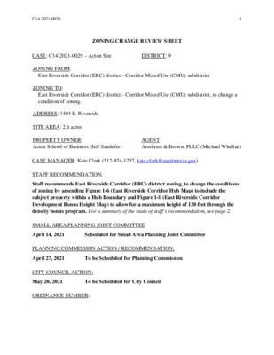
C14-2021-0029 1 ZONING CHANGE REVIEW SHEET CASE: C14-2021-0029 – Acton Site DISTRICT: 9 East Riverside Corridor (ERC) district - Corridor Mixed Use (CMU) subdistrict East Riverside Corridor (ERC) district - Corridor Mixed Use (CMU) subdistrict, to change a condition of zoning. ZONING FROM: ZONING TO: ADDRESS: 1404 E. Riverside SITE AREA: 2.6 acres PROPERTY OWNER: Acton School of Business (Jeff Sandefer) AGENT: Armbrust & Brown, PLLC (Michael Whellan) CASE MANAGER: Kate Clark (512-974-1237, kate.clark@austintexas.gov) STAFF RECOMMENDATION: Staff recommends East Riverside Corridor (ERC) district zoning, to change the conditions of zoning by amending Figure 1-6 (East Riverside Corridor Hub Map) to include the subject property within a Hub Boundary and Figure 1-8 (East Riverside Corridor Development Bonus Height Map) to allow for a maximum height of 120 feet through the density bonus program. For a summary of the basis of staff’s recommendation, see page 2. SMALL AREA PLANNING JOINT COMMITTEE April 14, 2021 Scheduled for Small Area Planning Joint Committee PLANNING COMMISSION ACTION / RECOMMENDATION: April 27, 2021 To be Scheduled for Planning Commission CITY COUNCIL ACTION: May 20, 2021 To be Scheduled for City Council ORDINANCE NUMBER: C14-2021-0029 2 ISSUES There are no known issues at this time and staff has not received any written or emailed comments in favor of or in opposition to this rezoning case. CASE MANAGER COMMENTS: This site currently contains the Acton School of Business and is zoned ERC with a subdistrict designation of CMU. It is approximately 2.6 acres and is located on the north side of E. Riverside Drive. It is adjacent to existing ERC zoned properties to the west, east and across E. Riverside Drive to the south. Adjacent properties to the west and east are also designated as CMU subdistricts and the property to the south is designated as a Neighborhood Mixed Use (NMU) subdistrict. Adjacent to the north is the Lady Bird Lake and is not zoned. Please see Exhibit A: Zoning Map, Exhibit B: Aerial Map and Exhibit C: ERC Maps. The applicant is not requesting to rezone their subdistrict or change any of the base entitlements currently allowed. They are requesting to amend Figure 1-6 (East Riverside Corridor Hub Map) to include the subject property which would allow for the owner to participate in the development bonus program, and to Figure 1-8 (East Riverside Corridor Development Bonus Height Map) which would allow up to 120’ in height if the project met the development bonus requirements. This site is located within the East Riverside subdistrict of the Waterfront Overlay which restricts height to a maximum of 96’. If the rezoning request is approved by City Council, the Waterfront Overlay height restriction of 96’ would supersede any additional height granted through the ERC Regulating Plan. Per the applicant’s application and cover letter, they are requesting to amend the Figures “in order to develop a multi-family project with up to 250 units, including on-site units affordable at 60 percent of Median Family Income.” Due to the number of proposed residential units, staff sent AISD the Educational Impact Statement (EIS) forms provided in the rezoning application. Their response is included in Exhibit D: EIS from AISD. BASIS OF RECOMMENDATION: 1. The proposed zoning should be consistent with the goals and objectives of the City Council. Staff has been asked to consider appropriate locations for additional housing within our City. This site is located along E. Riverside Drive which is identified as a Core Transit Corridor within the ERC. The current CapMetro bus system map shows two existing High-Frequency MetroBus routes as well as other regular routes along this portion of E. Riverside Drive. It is also along the proposed Blue Line of Project Connect, a future light rail route planned to run from North Lamar and U.S. 183 through downtown and to the airport. This site does not contain any existing residential uses. Should the applicant’s request for rezoning be granted by City Council, redevelopment of the site would not cause any displacement of existing residents. Additionally, the increased entitlements to this site would only be allowed if the applicant complied with the development bonus program of the ERC Regulating Plan. C14-2021-0029 3 EXISTING ZONING AND LAND USES: Site North South East West Zoning Land Uses ERC (CMU subdistrict) College and University Facilities Not zoned Lady Bird Lake ERC (NMU subdistrict) Administrative and Business Offices ERC (CMU subdistrict) Multifamily ERC (CMU subdistrict) Multifamily NEIGHBORHOOD PLANNING AREA: East Riverside Corridor (Riverside NP Area) TIA: deferred until site plan. WATERSHED: Lady Bird Lake and Harper’s Branch Watersheds OVERLAYS: ADU Approximate Area Reduced Parking, Residential Design Standards (LDC/25-2-Subchapter F), Scenic Roadways Overlay (Riverside Drive), Selected Sign Ordinances and Waterfront Overlay (East Riverside). SCHOOLS: Sanchez Elementary, Martin Middle and Austin High Schools NEIGHBORHOOD ORGANIZATIONS Austin Independent School District Austin Lost and Found Pets Austin Neighborhoods Council Bike Austin Friends of Riverside ATX Neighborhood Homeless Neighborhood Association Neighborhood Empowerment Foundation Neighbors United for Progress Crossing Gardenhome Owners Assn. (The) Pleasant Valley Del Valle Community Coalition Preservation Austin East Austin Conservancy East Cesar Chavez Neighborhood Association East Riverside Corridor Staff Liaison East Riverside/Oltorf Neighborhood Plan East Town Lake Citizens Neighborhood El Concilio Mexican-American Neighborhoods Friends of Austin Neighborhoods SELTexas Sierra Club, Austin Regional Group South Central Coalition South River City Citizens Assn. Southeast Austin Neighborhood Alliance Tejano Town Waterfront Condominium Homeowners Zoning Committee of South River City Citizens C14-2021-0029 4 AREA CASE HISTORIES: Number Request Commission City Council C14-2020-0081 SF-3-NP to NO-MU-NP 1100 Manlove Street Time Insurance Two C14-06-0117 GR-MU to LI-PDA C14-06-0053 Riverside Drive Residential Development Tract 1: GO & LO to L- CO Tract 2: CS-1 to GO-CO Tract 3: LO to MF-6-CO Tract 4: LO to GO-CO Forwarded to City Council without a recommendation. Case was indefinitely postponed on March 25, 2021. To grant LI-PDA with a set of prohibited land uses, altered various site development regulations and impose residential requirements. Approved GR-MU- CO; CO was for a set of prohibited land uses, maximum impervious cover of 85%, and altered sited development regulations. (1/10/08) Approved staff recommendations with one change to Tract 1. CO was to limit trips per day to 2000 on all tracts and height on Tract 1 to 190’. Approved the following: Tract 1: L-CO Tract 2: GO-CO Tract 3: MF-6-CO Tract 4: GO-CO CO was to limit trips per day to 2000 on all tracts and height on Tract 1 to 120’. (7/27/06) RELATED CASES: C14-2012-0111 (East Riverside Corridor Regulating Plan-East Riverside Oltorf Combined Neighborhood): this case rezoned approximately 700 acres from various to ERC. ERC base district zoning was granted by City Council on May 9, 2013 (Ordinance No. 20130509-039). C14-2011-0129 (East Riverside Corridor Regulating Plan): this case attempted to rezone approximately 1,000 acres from various to ERC. Rezoning case expired, Planning Commission and City Council did not take action on this case. C14-01-0002 (Vintage on Town Lake): this rezoning case included a portion of the current requested zoning area. This case rezoned approximately 1.7 acres from SF-3 and LO to MF-6- CO and MF-4-CO. C14-2021-0029 5 EXISTING STREET CHARACTERISTICS: Street ROW Pavement Classification Sidewalks Bike Route Capital Metro (within ¼ mile) 140’ 80’ Yes Yes Riverside Dr Variable atm. 128’- 151’ Manlove St 50’ 3 1 Existing ROW 23’ Yes No OTHER STAFF COMMENTS: East Riverside Corridor Regulating Plan (ERC) Review The subject property is located within the ERC planning boundary and currently zoned as Corridor Mixed Use (CMU), the most intensive district as it relates to density and height. The applicant is requesting to rezone this property to allow for participation in the Regulating Plan’s Density Bonus Program, for the purpose of developing a 250-unit multi-family project. • The existing zoning of the property allows for a height up to 60 feet and 2:1 floor area ratio (FAR). The applicant is requesting that the property be included in the Hub, which grants participation in the Density Bonus Program, in addition to allow for a max height up to 120 feet. • The property is located within the Waterfront Overlay, which only allows for a building height up to 96 feet. The applicant does not intend to exceed the 96-foot limit, however, out of the additional height options the Regulating Plan currently offers, the 120-foot option is the most viable option to request. The allowance to participate in the density bonus program to obtain the requested height of 120’ will allow for more affordable housing and promotes higher-density, which supports transit development along this Future Rail Line corridor. The property is located along the ERC Core Transit Corridor. Based on the information above, staff believes that the proposed rezoning change request is supported by the East Riverside Corridor Regulating Plan. Environmental 1. The site is not located over the Edwards Aquifer Recharge Zone. The site is located in the Lady Bird Lake and partially in the Harper’s Branch Watersheds of the Colorado River Basin, which are classified as Urban Watersheds by Chapter 25-8 of the City's Land Development Code. C14-2021-0029 6 2. Zoning district impervious cover limits apply in the Urban Watershed classification. 3. According to floodplain maps there is a floodplain within or adjacent to the project location. 4. According to City of Austin GIS, there is a Critical Water Quality Zone on the project site. Development within a Critical Water Quality Zone is restricted except for that allowed with LDC 25-8-261. 5. Standard landscaping and tree protection will be required in accordance with LDC 25-2 and 25-8 for all development and/or redevelopment. 6. At this time, site specific information is unavailable regarding vegetation, areas of steep slope, or other environmental features such as bluffs, springs, canyon rimrock, caves, sinkholes, and wetlands. 7. This site is required to provide on-site water quality controls (or payment in lieu of) for all development and/or redevelopment when 8,000 square feet cumulative is exceeded, and on site control for the two-year storm. 8. At this time, no information has been provided as to whether this property has any preexisting approvals that preempt current water quality or Code requirements. PARD Review PR1: Parkland dedication will be required for the new residential units proposed by this development, multifamily with ERC-CMU zoning, at the time of subdivision or site plan, per City Code § 25-1-601. Whether the requirement shall be met with fees in-lieu or dedicated land will be determined using the criteria in City Code Title 25, Article 14, as amended. The East Riverside Corridor Regulating Plan has specific requirements regarding the eligibility for the development bonus: to be eligible for the bonus, there must be some parkland dedicated as part of the development (cannot be satisfied only through fee in-lieu). See Article 6.4.2 of the Regulating Plan. PARD approval is required to authorize the development bonus. PARD is prepared to discuss waterfront dedication and other configurations that would meet the parkland standards outlined City Code § 25-1-603. Should fees in-lieu also be required, those fees shall be used toward park investments in the form of land acquisition and/or park amenities within the surrounding area, per the Parkland Dedication Operating Procedures § 14.3.11 and City Code § 25-1-607 (B)(1) & (2). If the applicant wishes to discuss parkland dedication requirements in advance of site plan or subdivision applications, please contact this reviewer: thomas.rowlinson@austintexas.gov. At the applicant’s request, PARD can provide an early determination of whether fees in-lieu of land will be allowed. C14-2021-0029 7 Site Plan SP1. This site is located in the Waterfront Overlay-East Riverside. SP2. This site is located in the East Riverside Corridor Regulating Plan, CMU district. SP3. Site plans will be required for any new development other than single-family or duplex residential. Transportation The Austin Strategic Mobility Plan (ASMP), adopted 04/11/2019, identifies a need for 140’ of right-of-way for Riverside Drive and existing right-of-way is sufficient for Manlove Street. Traffic impact analysis was waived at this time, the determination is deferred to site plan application, when land use and intensity will be finalized. Austin Water Utility AW1. The landowner intends to serve the site with City of Austin water and wastewater utilities. The landowner, at own expense, will be responsible for providing any water and wastewater utility improvements, offsite main extensions, utility relocations and or abandonments required by the land use. The water and wastewater utility plan must be reviewed and approved by Austin Water for compliance with City criteria and suitability for operation and maintenance. Depending on the development plans submitted, water and or wastewater service extension requests may be required. All water and wastewater construction must be inspected by the City of Austin. The landowner must pay the City inspection fee with the utility construction. The landowner must pay the tap and impact fee once the landowner makes an application for a City of Austin water and wastewater utility tap permit. INDEX OF EXHIBITS TO FOLLOW Exhibit A: Zoning Map Exhibit B: Aerial Map Exhibit C: ERC Maps Exhibit D: EIS from AISD P-NP 1-A 2-A 1 S I H F L O R E S 3 5 N B T O R A M P E R W N B B I V E R T A O R S M 3 I D 5 P E S I H 3 5 S B S I H 3 5 S V R D S B S I H 3 5 N B B S 5 3 H I S N A G A E R O T P M A R TRACT B GO-CO-NP ± 1'' = 200' LOT A C14-2021-0029 J20 B E SID P R M E A B R E S 35 N TO RIV S I H 3 5 S V R D N B ERC 1 1 3 E R I V E R S I D E D R ERC 2 2 3 1 GR-MU-CO 2 SF-3-NP 1A 1B 4 T S E V O L N A M 17 16 LR-NP IN GLE W O O 15 14 D ST 12 13 14A SF-3-NP 8A T MIT S M U S 3 2 ERC O RIV E L D E SID R 1 1 A S T E D R 2 SUBJECT TRACT ZONING BOUNDARY ! ! ! ! ! ! PENDING CASE CREEK BUFFER Action Site ZONING CASE#: LOCATION: SUBJECT AREA: GRID: MANAGER: C14-2021-0029 1404 E. Riverside Dr. 2.66 ACRES J20 KATE CLARK This map has been produced by the Communications Technology Management Dept. on behalf of the Planning Development Review Dept. for the sole purpose of geographic reference. No warranty is made by the City of Austin regarding specific accuracy or completeness. P-NP S I H F L O R E S 3 5 N B T O R A M P E R W N B B I V E R T A O R S M 3 I D 5 P E S I H 3 5 S B S I H 3 5 S V R D S B S I H 3 5 N B B S 5 3 H I S N A G A E R O T P M A R TRACT B GO-CO-NP ± 1'' = 200' LOT A C14-2021-0029 J20 ERC 1 B E SID P R M E A B R E S 35 N TO RIV S I H 3 5 S V R D N B 1 3 E R I V E R S I D E D R ERC 2 2 3 1 GR-MU-CO 2 SF-3-NP 1A 1B 4 T S E V O L N A M 17 16 LR-NP IN GLE W O O 15 14 D ST 12 13 14A SF-3-NP 8A T MIT S M U S 3 2 ERC O RIV E L D E SID R 1 1 A S T E D R 2 1-A 2-A 1 Copyright nearmap 2015 SUBJECT TRACT ZONING BOUNDARY ! ! ! ! ! ! PENDING CASE CREEK BUFFER Action Site ZONING CASE#: LOCATION: SUBJECT AREA: GRID: MANAGER: C14-2021-0029 1404 E. Riverside Dr. 2.66 ACRES J20 KATE CLARK This map has been produced by the Communications Technology Management Dept. on behalf of the Planning Development Review Dept. for the sole purpose of geographic reference. No warranty is made by the City of Austin regarding specific accuracy or completeness. FIGURE 1-6: East Riverside Corridor Hub Map This map shows the Hubs within the ERC boundary. Properties located within a Hub are eligible for additional entitlements as outlined in Article 6. LEGEND Hub Boundary ERC Planning Area Boundary Parcel Zoned ERC Parcel within the ERC Boundary not re-zoned as part of the ERC process SCALE NORTH 0 1000’ 500’ 2000’ 16 This product is for informational purposes and may not have been prepared for or be suitable for legal, engineering, or surveying purposes. It does not represent an on-the-ground survey and represents only the approximate relative location of property boundaries. This product has been produced by the Planning and Development Review Department for the sole purpose of geographic reference. No warranty is made by the City of Austin regarding specific accuracy or completeness. As amended per Ordinance No. _______________ adopted ____________ . 20141106-084 11-17-2014 City of Austin - East Riverside Corridor Regulating Plan FIGURE 1-8: East Riverside Corridor Development Bonus Height Map This map shows eligible properties and maximum heights allowed with a development bonus. LEGEND Ineligible for Development Bonus 65 feet 120 feet 160 feet ERC Planning Area Boundary Parcel Boundary Parcel within the ERC Boundary not re-zoned as part of ERC process 500’ 2000’ SCALE NORTH 0 1000’ This product is for informational purposes and may not have been prepared for or be suitable for legal, engineering, or surveying purposes. It does not represent an on-the-ground survey and represents only the approximate relative location of property boundaries. This product has been produced by the Planning and Development Review Department for the sole purpose of geographic reference. No warranty is made by the City of Austin regarding specific accuracy or completeness. 18 City of Austin - East Riverside Corridor Regulating Plan As amended per Ordinance No. _______________ adopted ____________ . 20141106-084 11-17-2014 EDUCATIONAL IMPACT STATEMENT Prepared for the City of Austin Austin Independent School District PROJECT NAME: Acton Site ADDRESS/LOCATION: 1404 E. Riverside Dr. CASE #: C14-2021-0029 NEW SINGLE FAMILY NEW MULTIFAMILY DEMOLITION OF MULTIFAMILY TAX CREDIT STUDENTS PER UNIT ASSUMPTION Elementary School: STUDENTS PER UNIT ASSUMPTION Elementary School: .004 Middle School: High School: Middle School: .004 High School: .005 # SF UNITS: # MF UNITS: 250 IMPACT ON SCHOOLS The student yield factor of 0.013 (across all grade levels) for apartment homes was used to determine the number of projected students. The application did not include proposed rental rates, therefore, the student yield factor, provided by the district’s demographer is based on other market rate multifamily complexes built within the area. The proposed 250-unit multifamily development is projected to add approximately 3 students across all grade levels to the projected student population. It is estimated that of the 3 students, 1 will be assigned to Sanchez Elementary School, 1 to Martin Middle School, and 1 to Austin High School. Please note, a new Sanchez campus is currently under construction as part of the 2017 Bond Program, and scheduled to open in SY 2021-22. The data provided shows the merging of the Sanchez and Metz campuses. The percent of permanent capacity by enrollment for School Year 2025/26, including the additional students projected with this development, would be within the optimal utilization target range of 85-110% at Austin HS (101%), and below the target range at Sanchez ES (80%) and Martin (27%). The projected additional students at Sanchez and Martin would not offset the anticipated decline in student enrollment. All of these schools will be able to accommodate the projected additional student population from the proposed development. TRANSPORTATION IMPACT Students within the proposed development attending Sanchez ES, Martin MS, or Austin HS will qualify for transportation. SAFETY IMPACT There are not any identified safety impacts at this time. Date Prepared: Executive Director: [1] 4/1/2021 EDUCATIONAL IMPACT STATEMENT Prepared for the City of Austin Austin Independent School District PERMANENT CAPACITY: MOBILITY RATE: +14.4% 594* 5- Year Projected Population (without proposed development) 5-Year Projected Population (with proposed development) Sanchez (with Metz) DATA ANALYSIS WORKSHEET ELEMENTARY SCHOOL: ADDRESS: 8400 Robert T. Martinez Jr. St. POPULATION (without mobility rate) ELEMENTARY SCHOOL STUDENTS 2020-21 Population Number 341 57% % of Permanent Capacity ENROLLMENT (with mobility rate) ELEMENTARY SCHOOL STUDENTS 2020-21 Enrollment MIDDLE SCHOOL: Martin ADDRESS: 1601 Haskell St. POPULATION (without mobility rate) MIDDLE SCHOOL STUDENTS 2020-21 Population Number 882 110% % of Permanent Capacity ENROLLMENT (with mobility rate) MIDDLE SCHOOL STUDENTS 2020-21 Enrollment Number % of Permanent Capacity 503 63% 421 71% 604 75% 218 27% [2] 5- Year Projected Enrollment (without proposed development) 5-Year Projected Enrollment (with proposed development) Number 390 475 % of Permanent Capacity *594 is the preliminary capacity calculation based on the new Sanchez campus. 66% 80% PERMANENT CAPACITY: MOBILITY RATE: -43.0% 804 5- Year Projected Population (without proposed development) 5-Year Projected Population (with proposed development) 5- Year Projected Enrollment (without proposed development) 5-Year Projected Enrollment (with proposed development) 422 71% 476 80% 605 75% 219 27% EDUCATIONAL IMPACT STATEMENT Prepared for the City of Austin Austin Independent School District HIGH SCHOOL: Austin ADDRESS: 1715 W. Cesar Chavez St. POPULATION (without mobility rate) HIGH SCHOOL STUDENTS 2020-21 Population Number 2,110 94% % of Permanent Capacity ENROLLMENT (with mobility rate) HIGH SCHOOL STUDENTS 2020-21 Enrollment Number % of Permanent Capacity 2,353 105% PERMANENT CAPACITY: MOBILITY RATE: +11.5% 2,247 5- Year Projected Population (without proposed development) 5-Year Projected Population (with proposed development) 5- Year Projected Enrollment (without proposed development) 5-Year Projected Enrollment (with proposed development) 2,038 91% 2,270 101% 2,037 91% 2,269 101% [3]