Item 4.a - 218 S Lamar PUD — original pdf
Backup
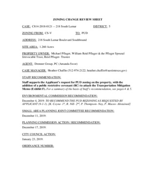
ZONING CHANGE REVIEW SHEET CASE: C814-2018-0121 -- 218 South Lamar DISTRICT: 5 ZONING FROM: CS-V TO: PUD ADDRESS: 218 South Lamar Boulevard Southbound SITE AREA: 1.260 Acres PROPERTY OWNER: Michael Pfluger, William Reid Pfluger & the Pfluger Spousal Irrevocable Trust, Reid Pfluger- Trustee AGENT: Drenner Group, PC (Amanda Swor) CASE MANAGER: Heather Chaffin (512-974-2122; heather.chaffin@austintexas.gov) STAFF RECOMMENDATION: Staff supports the Applicant’s request for PUD zoning on the property, with the addition of a public restrictive covenant (RC) to attach the Transportation Mitigation Memo (Exhibit F). For a summary of the basis of Staff’s recommendation, see pages 4 & 5. ENVIRONMENTAL COMMISSION RECOMMENDATION: December 4, 2019: TO RECOMMEND THE PUD REZONING AS REQUESTED BY APPLICANT (9-1-1). [K. Coyne- 1st, R. Nill- 2nd, P. Thompson- Nay, P. Maceo- Abstained] SMALL AREA PLANNING JOINT COMMITTEE RECOMMENDATION: December 11, 2019: PLANNING COMMISSION ACTION / RECOMMENDATION: December 17, 2019: CITY COUNCIL ACTION: January 23, 2019: ORDINANCE NUMBER: C814-2018-0121 Page 2 CASE MANAGER COMMENTS: Existing Conditions. The subject property is a 1.260 acre lot at the northwest corner of South Lamar Boulevard Southbound and Toomey Road. The property is zoned CS-V and is currently developed with a Schlotzsky’s restaurant. The property is located in the Butler Shores subdistrict of the Waterfront Overlay. Immediately to the north and west of the property are City of Austin Parks and Recreation Department (PARD) park and related facilities including ZACH Theatre facilities, the People’s Plaza, and PARD offices. The PARD property is primarily zoned P-Public except for small portions that are zoned CS and CS-1. Across Toomey Road to the south is the Cole Building, a mixed use building with apartments, restaurant, retail, and other pedestrian-oriented land uses. Further south are properties zoned CS and CS-V with a mix of commercial uses including hotel, retail, and more. Southwest of the rezoning tract are properties with a mix of commercial uses including City offices and facilities. East of the subject property, across Lamar Boulevard, are properties zoned CS-1 and CS that are developed with a Bridges on the Park condominiums and a mix of commercial uses including personal services, retail, and more. Northeast of the proposed rezoning tract at the southeast corner of Riverside Drive and South Lamar Boulevard Northbound is 211 South Lamar, also known as Taco PUD. Please refer to Exhibits A and B – Zoning Map and Aerial Exhibit. The focus of the Applicant’s request is to increase the maximum building height from 60’ to 96’. Most properties along this stretch of South Lamar Boulevard have CS base zoning like this site, and therefore are limited to 60’ of building height. Notable exceptions are the Topher Theatre and the 211 South Lamar PUD. An ordinance was passed in 2008 (Ord. No. 20080724-82) to create a height exception for fly towers associated with a public performing arts theater. This allows the Topher Theatre to reach 80’ in height. In 2013 Cith Council approved the PUD ordinance for 211 South Lamar (Ord. No. 20131017-052), which approved 96’ in height for a residential/mixed use building. In 2019, Council approved an ordinance amending the PUD, but the permitted height remained unchanged (Ord. No. 20191017-079). The amendment at 211 South Lamar was to change to a hotel/mixed use building. Existing Overlays. As stated above, the property is in the Butler Shores subdistrict of the Waterfront Overlay (WO). The subdistrict establishes design standards and permitted land uses that are more restrictive than the base zoning category. For example, although the property is currently zoned CS-V, at least 50% of the first floor of any development is limited to eleven land uses that are considered pedestrian-oriented. As part of the PUD request, the Applicant states that the requirements of the WO are the special circumstances that affect the site, since the site is less than 10 acres. Please refer to Exhibit C – Waterfront Overlay Regulations. The property also currently is subject to the Vertical Mixed Use (V or VMU) overlay. This allows increased development intensity on a site if certain conditions are met, but VMU does not allow increased height. Transportation. Under City Code, South Lamar Boulevard is designated as a Core Transit Corridor. South Lamar has also been designated as a Level 3 roadway in the Austin Strategic Mobility Plan (ASMP). The ASMP also identifies this area of South Lamar as a Transit Priority Network, Bicycle Priority Network, and Vehicle Priority Network. The Imagine C814-2018-0121 Page 3 Austin Comprehensive Plan (IACP) identifies this corridor as a Growth Concept Corridor. These designations all reflect the current role of South Lamar as a major roadway that is anticipated to experience continued growth and establishes prioritized improvements for the corridor. Draft Land Development Code. The current draft Code Identifies this property with a MU5A Corridor zoning designation. Mixed-Use 5A (MU5A) zone is intended to allow high-intensity multi-unit residential, office, service, retail, and entertainment uses. The Bridges on the Park across Lamar are also designated as MU5A and other properties south between Toomey Road and Barton Springs Road are designated MS3 Main Street Zone district. Main Street 3 (MS3) zone is intended to provide housing and convenient access to services and amenities for nearby residents in a high-intensity urban main street environment with active frontages located in regional centers, or along well-connected corridors served by frequent transit. Please refer to Exhibit D- Draft Proposed LDC. Proposed Rezoning. The Applicant is requesting PUD zoning to allow redevelopment of the property with an office building with mixed pedestrian-oriented uses on the ground floor. In brief, the Applicant is requesting to: •Increase the maximum building height from 60’ height to 96’; elevator equipment canexceed height by 20% (15% per code)•Increase floor-to-area ratio (FAR) from 2:1 to 3.55:1•Reduce all building setbacks to 0’. The existing CS base zoning district requires a 10’front and street side yard setback.•Add administrative/business offices as ground floor pedestrian oriented use;administrative/business office use not to exceed 50% of ground floor usesThe Applicant is proposing the following items to meet Tier 1 and Tier 2 PUD requirements: •The rooftop deck would be made available by reservation to local non-profits.•3-star Green Building•Street yard landscaping will exceed minimum code requirements by 35%. Landscapearea soil depth will exceed minimum code requirements by 6 inches.•Landscaping will use native/adaptive species•Contribute a minimum of $20,000 (not to exceed $27,800) toward a planned CapitalMetro bus stop upgrade adjacent to the site and $25, 000 toward bike track•Enhance supplemental zones along Lamar including 7’ planting zone, 10’ bike track,and 15’ landscape /sidewalk zone•100 caliper inches of trees•Adopt an Integrated Pest Management (IPM) plan•Provide onsite Art in Public Spaces•Provide a direct pedestrian connection between this site and the PARD-owned park andrelated facilities to the north and west•Exceed bike parking by 120%•Provide electric vehicle parking spaces•No surface level parking, all subgrade parking•No onsite residential will be provided; the property owner will pay a fee-in-lieu towardhousing in the area at a rate determined by Neighborhood Housing and ConservationDepartment (NHCD) C814-2018-0121 Page 4 •Participate in purple pipe reclaimed water system when available; double piping untilthen•Four ADA accessible shower facilities•Parking on this site will be a community benefit by adding parking for nearby park andtheater users. This will not be free or reserved, it will be regular paid parking.Tables drafted by the Applicant that outline these proposed conditions are attached. Please refer to Exhibits E and F- PUD Waterfront Overlay Variances Table and Tier 1 & Tier 2 Compliance Exhibit. Transportation Impact. As stated above, South Lamar has also been designated in several Council-adopted planning and regulatory documents as a major roadway that is anticipated to experience continued growth. These plans establish prioritized improvements for the corridor. As part of the rezoning request, the Applicant has prepared a Traffic Impact Analysis (TIA) that has been reviewed by City Staff. Staff has outlined a plan for the Applicant to provide onsite transportation improvements and pay monies toward nearby, off-site improvements. The Applicant has agreed to these conditions of zoning. Please refer to Exhibit G- Traffic Mitigation Memorandum. Affordable Housing Fee-in-Lieu. The Applicant has agreed to terms approved by NHCD: A.Dwelling units equal to not less 10 percent of the bonus area devoted to a residentialrental use shall be leased on an ongoing basis to households earning no more than 60percent of the median family income for the Austin-Round Rock Metropolitan StatisticalArea for a period not less than 40 years from the date a final certificate of occupancy isissued for the property. The property owner shall enter into a restrictive covenant withthe City of Austin enumerating these requirements as necessary to ensure compliancewith this provision.B.Dwelling units equal to not less than 5 percent of the bonus area devoted to aresidential owner-occupied use shall be sold to income-eligible homebuyers earning nomore than 80 percent of the median family income for the Austin-Round RockMetropolitan Statistical Area. Each affordable owner-occupied unit shall be restrictedby a fixed equity and resale agreement approved by NHCD for a period not less than 99years from the date a final certificate of occupancy is issued for the property. If acondominium declaration will be filed for the property, NHCD shall have the right toreview and insert provisions related to the affordable units prior to filing.C.The property owner shall pay a fee-in-lieu of on-site affordable housing to NHCDnot less than an amount equal to the planned unit development fee rate current at thetime of site plan submittal times the bonus square footage devoted to non-residential use.D.NHCD shall have the right to establish additional guidelines and processes to ensurecompliance with the affordability requirements applicable to the PUD.A site plan is under City review for construction of a 7-story office building with ground floor commercial uses and other amenities (SP-2019-0279C). Affordable housing fees will be calculated prior to site plan approval. Please refer to Exhibit H- NHCD Letter. Correspondence. Staff has received correspondence regarding the proposed rezoning. Please refer to Exhibit I- Correspondence. C814-2018-0121 Page 5 Other Exhibits. The final Staff Comment Review Report is attached, as well as the proposed Land Use Plan. Please refer to Exhibits J and K- Staff Comment Report and PUD Land Use Plan. The Carbon Impact Statement prepared by the Applicant is attached but has not yet been evaluated by Staff in the Office of Sustainability. Also attached is the presentation made by Watershed Protection Staff to the Environmental Commission on December 4, 2019. Please refer to Exhibits L and M- Carbon Impact Statement and Environmental Commission Presentation. STAFF RECOMMENDATION: Staff supports the requested PUD zoning with the addition of a public restrictive covenant (RC) to attach the Transportation Mitigation Memo (The Applicant has agreed to this condition.) The Butler Shores subdistrict and overall Waterfront Overlay were created in the late 1990s and do not reflect the rapid growth of our city over the past 20 years. City Council has placed a high priority on densification of the central city to reduce traffic impacts of the continued growth. Beginning in the mid-2010s, increased heights have been approved in the Butler Shores subdistrict and other parts of the Waterfront Overlay. In addition to the Topher Theatre and 211 South Lamar, a 15-story office/mixed use building has been approved at 425 Riverside (“Snoopy PUD”) and 6-story residential/mixed use building at 422 Riverside (“RunTex PUD”). Additional buildings have “grandfathered” entitlements that allow increased height, including The Catherine and the Austin American-Statesmen site. The Statesman site is currently under City review for a PUD that could allow heights up to 540’. While most of these properties are located near South First Street and Congress Avenue, the increases in height have extended west to Lamar Boulevard. As stated above, South Lamar has also been designated in several Council-adopted planning and regulatory documents as a major roadway that is anticipated to experience continued growth. These plans establish prioritized improvements for the corridor. As part of the rezoning request, the Applicant has agreed to participate in the corridor improvements, and the scale of the proposed development reflects the anticipated growth in the area. BASIS OF STAFF RECOMMENDATION: 1.The proposed zoning should be consistent with the purpose statement of the districtsought.Per the Land Development Code, the Planned Unit Development (PUD) zoning district hasbeen established to implement the goals of preserving the natural environment, encouraginghigh quality development and innovative design, and ensuring adequate public facilities andservices. The City Council intends PUD district zoning to produce development thatachieves these goals to a greater degree than and that is therefore superior to developmentunder conventional zoning and subdivision regulations.The proposed PUD offers a development on the subject property that can create a mixed use space that connects South Lamar Boulevard to the Zach Theatre and PARD parkland. The PUD would provide a ground floor plaza adjacent to the park and streetscape improvements along Lamar. The PUD would provide pedestrian-oriented uses on the ground floor, upper story office uses, underground vehicular parking, charging stations for electric vehicles, C814-2018-0121 Page 6 landscaping with 100% native and adapted plants, rainwater harvesting, and more. In addition, the proposed PUD amendment supports affordable housing initiatives via a fee-in-lieu of onsite dwelling units. The development would contribute onsite and adjacent transportation benefits as well as contribute to offsite improvements. The development would achieve a 3-star rating under the Austin Green Building program, provide additional bike parking for tenants and others. 2.Granting of the request should result in an equal treatment of similarly situatedproperties.Height increases have been granted to the nearby Topher Theatre (70’) and 211 South Lamar(96’), as well as other properties that are located in other subdistricts of the WaterfrontOverlay.3.The rezoning should be consistent with the policies and principles adopted by the CityCouncil or Planning Commission.As stated previously, the proposed rezoning is consistent with several policies and plansadopted by Planning Commission and City Council: Core Transit Corridor regulations; theASMP, which identifies this area as a Transit Priority Network, Bicycle Priority Network,and Vehicle Priority Network. The Imagine Austin Comprehensive Plan (IACP) identifiesthis corridor as a Growth Concept Corridor.EXISTING ZONING AND LAND USES: ZONING LAND USES Site CS-V Limited restaurant North P, CS-1 Public park, Performing arts center South CS Multifamily, General restaurant, Personal services, Limited retail, Hotel, etc. East CS, CS-1 Condominium residential, Personal services, Limited retail, etc. West P, CS Public park, Performing arts center/support facilities NEIGHBORHOOD PLANNING AREA: South Lamar Combined (Zilker) – Suspended AREA STUDY: Town Lake Corridor Study (1985) WATERFRONT OVERLAY: Butler Shores Subdistrict (Property is outside of primary and secondary setbacks) TRANSPORTATION MITIGATION: Required – Please refer to Attachment F. WATERSHED: Lady Bird Lake – Urban CAPITOL VIEW CORRIDOR: N/A SCENIC ROADWAY: N/A CORE TRANSIT CORRIDORS: South Lamar Boulevard SCHOOLS: Zilker Elementary School O. Henry Middle School Austin High School C814-2018-0121 Page 7 NEIGHBORHOOD ORGANIZATIONS: 57 – Old Austin Neighborhood Association 107 – Zilker Neighborhood Association 127 – Bouldin Creek Neighborhood Association 498 – South Central Coalition 511 – Austin Neighborhoods Council 742 – Austin Independent School District 943 – Save Our Springs Alliance 1074 – Bouldin Creek Neighborhood Planning Team 1107 – Perry Grid 614 1228 – Sierra Group, Austin Regional Group 1368 – Bridges on the Park 1363 – SEL Texas 1424 – Preservation Austin 1528 – Bike Austin 1530 – Friends of Austin Neighborhoods 1550 – Homeless Neighborhood Association 1571 – Friends of Zilker 1596 – TNR BCP - Travis County Natural Resources 1616 – Neighborhood Empowerment Foundation AREA CASE HISTORIES: NUMBER REQUEST COMMISSION CITY COUNCIL C814-2012-0160.01 211 S. Lamar PUD to PUD, to amend conditions of zoning 8-27-2019- Apvd with conditions- affordable housing fee-in-lieu Apvd 10-17-2019 C814-2012-0160 211 S. Lamar CS & CS-V to PUD 6-11-2013/ Apvd Apvd 10-17-2013 C14-2008-0060 – Zilker Vertical Mixed Use Building (V) Rezoning Opt-In/Opt Out Process Rezoning selected tracts with –V on 124 acres Apvd –V to certain tracts (73 acres) & an affordability level of 60% mfi for 10% of rental units in a VMU bldg Apvd 10-16-2008 EXISTING STREET CHARACTERISTICS: Name ROW Classification Sidewalks Bicycle Route Capital Metro (within ¼ mile) South Lamar Boulevard 120 feet Arterial / Level 3 (ASMP) Yes Yes Yes Toomey Road 50 feet Local collector Yes Yes Yes Jessie Street 50 feet Local collector Yes Yes Yes INDEX OF EXHIBITS TO FOLLOW A: Zoning Map B.Aerial ExhibitC.Draft Proposed LDC ExhibitD.Waterfront Overlay RegulationsE.Waterfront Overlay Variances TableF.Tier 1 & Tier 2 Compliance ExhibitG.Traffic Mitigation MemorandumH.NHCD LetterI.CorrespondenceJ.Staff Comment ReportK.PUD Land Use PlanL.Carbon Impact StatementM.Environmental Commission Presentation !!!!!!!!!!!!!!!!!!!!!!!!!!!!!!!!!!!!!!!!!!!!!!!!!!!!!!!!!!!!!!!!!!!!!!!!!!!!!!!!!!!!!!!!!!!!!!!!!!!!!!!!!!!!!!!!!!!!!!!!!!!!!!!!!!!!!!!!!!!!!!!!!!!!!!!!!!!!!!!!!!!!!!!!!!!!!!!!!!!!!!!!!!!!!!!!!!!!!!!!!!!!!!!!!!!!!!!!!!!!!!!!!!!!!!!!!!!!!!!!!!!!!!!!!!!!!!!!!!!!!!!!!!!!!!!!!!!!!!!!!!!!!!!!!!!!!!!!!!!!!!!!!!!!!!!!!!!!!!!!!!!!!!!!!!!!!!!!!!!!!!!!!!!!!!!!!!!!!!!!!!!!!!!!!!!!!!!!!!!!!!!!!!!!!!!!!!!!!!!!!!!!!!!!!!!!!!!!!!!!!!!!!!!!!!!!!!!!!!!!!!!!!!!!!!!!!!!!!!!!!!!!!!!!!!!!!!!!!!!!!!!!!!!!!!!!!!!!!!!!!!!!!!!!!!!!!!!!!!!!!!!!!!!!!!!!!!!!!!!!!!!!!!!!!!!!!!!!!!!!!!!!!!!!!!!!!!!!!!!!!!!!!!!!!!!!!!!!!!!!!!!!!!!!!!!!!!!!!!!!!!!!!!!!!!!!!!!!!!!!!!!!!!!!!!!!!!!!!!!!!!!!!!!!!!!!!!!!!!!!!!!!!!!!!!!!!!!!!!!!!!!!!!!!!!!!!!!!!!!!!!!!!!!!!!!!!!!!!!!!!!!!!!!!!!!!!!!!!!!!!!!!!!!!!!!!!!!!!!!!!!!!!!!!!!!!!!!!!!!!!!!!!!!!!!!!!!!!!!!!!!!!!!!!!!!!!!!!!!!!!!!!!!!!!!!!!!!!!!!!!!!!!!!!!!!!!!!!!!!!!!!!!!!!!!!!!!!!!!!!!!!!!!!!!!!!!!!!!!!!!!!!!!!!!!!!!!!!!!!!!!!!!!!!!!!!!!!!!!!!!!!!!!!!!!!!!!!!!!!!!!!!!!!!!!!!!!!!!!!!!!!!!!!!!!!!!!!!!!!!!!!!!!!!!!!!!!!!!!!!!!!!!!!!!!!!!!!!!!!!!!!!!!!!!!!!!!!!!!!!!!!!!!!!!!!!!!!!!!!!!!!!!!!!!!!!!!!!!!!!!!!!!!!!!!!!!!!!!!!!!!!!!!!!!!!!!!!!!!!!!!!!!!!!!!!!!!!!!!!!!!!!!!!!!!!!!!!!!!!!!!!!!!!!!!!!!!!!!!!!!!!!!!!!!!!!!!!!!!!!!!!!!!!!!!!!!!!!!C14-2008-0060C14-02-0031C14-2008-0060C14-2008-0060C814-2012-0160C14-07-0018C14-2008-0060C14-2008-0060C14-2008-0060C14-2008-0060C14-01-0177C14-2008-0060C14-2008-0060TOOMEY RDJESSIE STLEE BARTON DRS LAMAR BLVD SBS LAMAR BLVD NBBUTLER RDS LAMAR BLVDJOSEPHINE STW RIVERSIDE DRDAWSON RDPPCSPCSP-NPP-HCS-VCSCS-VCSPUDCS-VCSCS-1CS-VCS-VMF-6-COCS-HCS-VMF-5CS-1CS-1CS-VCS-1-VCS-1-VP.A.R.D.72-12989-0039SP-85-185C.O.A. OFFICEH93-0005C.O.A. PARKSSP-05-1279CSP-05-1664CSP85-18501-0177REST.GAS STA.87-074SP91-0179CSPC89-0143COFC.GLASS CO.AND RECREATION DEPT.WHSEM/HDELI RESTAURANTCONV.FASTFAST FOODPARKINGMOBILE HOMESTHEATERGOLF COURSESALONCARPENTERSTORER.V. PARKGASPHOTOFOOD78-154BUTLER PARKOFFICE07-0018SOCCER STOREPARKINGSALONREST.FOODFAST FOODGOLF COURSESPC89-0143CFASTPARKINGREST.WHSESTOREPLANNED UNIT DEVELOPMENT±This product is for informational purposes and may not have been prepared for or be suitable for legal,engineering, or surveying purposes. It does not represent an on-the-ground survey and represents only theapproximate relative location of property boundaries.This product has been produced by CTM for the sole purpose of geographic reference. No warranty is madeby the City of Austin regarding specific accuracy or completeness.ZONING CASE#:C814-2018-0121SUBJECT TRACT!!!!!!PENDING CASEZONING BOUNDARY1 " = 200 'EXHIBIT A 2131946913521B2121111237361912131104718A17135412814510B7118214610A92151152362-BA185967B814101623781A135C814-2018-0121PCS-1-VCSPP-NPMF-6-COPCS-1-NPCSPLRSF-3CS-VCSCS-VCS-VCS-VCS-1-VPUDPCS-1CS-1CSMF-3-NPCS-VCSCS-VSF-3SF-3CSP-NPCS-1P-HPCSCS-VCSMF-5P-NPCS-V-NPP-NPCS-VCS-1CS-HCS-1-V-NPP-NPPSANDRAMURAIDA WAYHILLMONTSTW CESARCHAVEZ STKINNEYAVEBARTON SPGTO LAMARNB RAMPN LAMARBLVDW 2ND STBUTLER RDDAWSON RDS LAMAR BLVDJOSEPHINE STJESSIE STW RIVERSIDE DRS LAMAR BLVD SBS LAMAR BLVD NBBARTON SPRINGS RDS LAMAR BLVDLEE BARTON DRTOOMEY RDH21H22Copyright nearmap 2015±This map has been produced by the Communications Technology Management Dept. on behalf of thePlanning Development Review Dept. for the sole purpose of geographic reference. No warranty is madeby the City of Austin regarding specific accuracy or completeness.ZONING CASE#:LOCATION:SUBJECT AREA:GRID:MANAGER:C814-2018-0121218 S. LAMAR BLVD1.27 AcresH22Heather Chaffin1'' = 300'ZONING BOUNDARYCREEK BUFFERPENDING CASE!!!!!!SUBJECT TRACT218 S. LAMAREXHIBIT B EXHIBIT C EXHIBIT D 218 S. Lamar PUD / Generational Commercial PUD Waterfront Overlay Variances Table October 9, 2019 Code Section Requirement Variance Request §25-2-691 (C) [WaterfrontOverlay (WO) District Uses]A pedestrian-oriented use is a use that serves the public by providing goods and services including: a)Art galleryb)Art workshopc)Cocktail lounged)Consumer convenienceservicese)Cultural servicesf)Day care services(limited, general orcommercial)g)Food salesh)General retail sales(convenience orgeneral)i)Park and recreationservicesj)Residential usesk)Restaurant (limited orgeneral) without drive-in servicesl)Other uses asdetermined by the LandUse Commission.Add administrative and business offices to the list of pedestrian oriented uses. §25-2-531 (C)(1) Height LimitExceptionsA structure described in Subsection (B) may exceed a zoning district height limit by the greater of: 1) 15 percent. Modification to Section 25-2-531(C)(1) to allow the elevator cab, and improvements necessary for elevator access to the roof deck, to exceed the maximum height of the PUD by twenty percent (20%) §25-2-492 Site DevelopmentRegulationsIn the CS base zoning district: Maximum Height: 60 feet Maximum FAR: 2:1 Minimum Setbacks Front Yard: 10 feet Street Side Yard: 10 feet Interior Side Yard: -- Rear Yard: -- In the PUD: Maximum Height: 96 feet Maximum FAR: 3.55:1 Minimum Setbacks Front Yard: 0 feet Street Side Yard: 0 feet Interior Side Yard: 0 feet Rear Yard: 0 feet EXHIBIT E 218 S. Lamar PUD Tier 1 & Tier 2 Compliance Updated October 9, 2019 1 Tier I Requirement Compliance Superiority Note # 2.3.1.A. Meet the objectives of the City Code. Yes. The project is located within the City of Austin’s Desired Development Zone as well as within the Urban Core. The project is situated along South Lamar Boulevard which is designated as a City of Austin Core Transit Corridor and also designated as an Activity Corridor under the City of Austin Imagine Austin Comprehensive Plan. Activity Corridors call for a variety of activities and types of buildings located along the roadways. Specifically, this project will provide an office use along the portion of the South Lamar Corridor between Riverside Drive and Barton Springs Road where there are currently no other office uses, thereby providing a vibrant, needed use to the Corridor. 2.3.1.B. Provide for development standards that achieve equal or greater consistency with the goals in Section 1.1 than development under the regulations in the Land Development Code. Yes. This project will create a high-quality development utilizing innovative design. In addition, the PUD will ensure adequate public facilities for the area. The mixed-use nature of the project is consistent with the pedestrian-oriented concept that is core to the Waterfront Overlay Ordinance and the development that was envisioned as part of Imagine Austin, adding the “work and play” portions to the goal of a “live, work, play” environment along this portion of South Lamar Boulevard. 2.3.1.C. Provide a total amount of open space that equals or exceeds 10% of the residential tracts, 15% of the industrial tracts, and 20% of the nonresidential tracts within the PUD, except that: Yes. The PUD will equal or exceed the open space standards by providing open space at grade and by providing a rooftop amenity deck. PUD Notes: 15, 23, 26 EXHIBIT F 218 S. Lamar PUD Tier 1 & Tier 2 Compliance Updated October 9, 2019 2 1.A detention or filtration area is excludedfrom the calculation unless it is designedand maintained as an amenity, and2.The required percentage of open spacemay be reduced for urban property withcharacteristic that make open spaceinfeasible if other community benefits areprovided.2.3.1.D. Provide a two-star Austin Energy Green Building Rating. Yes. The project will comply with the City of Austin’s Green Building Program at a 3-star level. PUD Note: 5 2.3.1.E. Be consistent with the applicable neighborhood plans, neighborhood conservation combining district regulations, historic area and landmark regulations and compatible with adjacent property and land uses. Yes The project is not located within an adopted City of Austin neighborhood planning area. Additionally, the project is in compliance with the City of Austin Waterfront Overlay regulations. The project is also consistent with surrounding land use as it is surrounded by Zach Scott Theater on the north and west and the Cole multifamily building to the south. To be consistent with neighborhood characteristics, the project will be Dark Skies compliant. PUD Note: 9 2.3.1.F. Provide for environmental preservation and protection relating to air quality, water quality, trees, buffer zones and greenbelt areas, critical environmental features, soils, waterways, topography and the natural and traditional character of the land. Yes. The project is not located within an environmentally sensitive area and the property does not contain any critical environmental features, waterway setbacks or significant topography changes. The property is partially located within the Edwards Aquifer Recharge Verification Zone and will provide an Environmental Resource Inventory at the time of the site development permit application. To enhance environmental preservation, the project will provide water quality controls that meet or exceed current Code for a site that is currently PUD Note: 8 218 S. Lamar PUD Tier 1 & Tier 2 Compliance Updated October 9, 2019 3 untreated and will be fully compliant with all environmental and tree regulations. 2.3.1.G. Provide for public facilities and services that are adequate to support the proposed development including school, fire protection, emergency service and police facilities. Yes. This project will have a positive impact to the school system by providing an increased tax base without the burden of additional students. Additionally, the project will not necessitate the additional City of Austin infrastructure costs associated with suburban development. The owner will work with City of Austin emergency services, fire and police facilities to determine that there is adequate support for the project during the development process for this proposed PUD. 2.3.1.H. Exceed the minimum landscaping requirements of the City Code. Yes. The PUD will exceed the minimum landscape requirements of the City Code and will utilize native and adaptive species as well as non-invasive plants per the City of Austin Grow Green program. PUD Notes: 27, 28 2.3.1.I. Provide for appropriate transportation and mass transit connections to areas adjacent to the PUD district and mitigation of adverse cumulative transportation impacts with sidewalks, trails and roadways. Yes. The project is situated within close proximity to two Cap Metro bus routes (including a bus stop on the property), the Bus Rapid Transit lines and operating bike share stations. The site is also less than one-half block from the Pfluger Bridge allowing bicycle and pedestrian access across Lady Bird Lake to Downtown Austin. The owner conducted a full Traffic Impact Analysis to determine the impact of the project on the transportation network. In coordination with the Corridor Program Office, improvements along South Lamar will be constructed, including sidewalks with a 7-foot planting zone with street trees, a 10-foot two-way cycle track, and a 15-foot landscape/sidewalk zone. PUD Notes: 24, 29, 35 218 S. Lamar PUD Tier 1 & Tier 2 Compliance Updated October 9, 2019 4 In coordination with Austin Transportation Department (ATD), the project will contribute funds to ATD for bus stop improvements on South Lamar Boulevard in an amount not to exceed $27,800, and $25,000 for cycle track improvements along South Lamar. 2.3.1.J. Prohibit gated roadways Yes. No gated roadways will be permitted within the PUD. PUD Note: 3 2.3.1.K. Protect, enhance and preserve the areas that include structures or sites that are of architectural, historical, archaeological or cultural significance. Yes. There are no areas within the PUD area that include structures or sites that are of architectural, historical, archaeological or cultural significance. 2.3.1.L. Include at least 10 acres of land, unless the property is characterized by special circumstances, including unique topographic constraints. Yes. The property does not exceed 10 acres of land but is characterized by special circumstances The PUD is located within the City of Austin Waterfront Overlay area and this site is prescribed for a maximum height of 96 feet per the overlay. At this time, the only way to achieve the additional height contemplated in the Waterfront Overlay is through the PUD process. 218 S. Lamar PUD Tier 1 & Tier 2 Compliance Updated October 9, 2019 5 Tier I - Additional PUD Requirements for a mixed use development Compliance Superiority Note # 2.3.2.A. Comply with Chapter 25-2, Subchapter E (Design Standards and Mixed Use) Yes. The project will comply with the City of Austin Subchapter E, Commercial Design Standards. In addition, the project will enhance all supplemental zones along Toomey Road and South Lamar Boulevard. PUD Notes: 20, 33 2.3.2.B. Inside the Urban Roadway boundary depicted in Figure 2, Subchapter E, Chapter 25-2 (Design Standards and Mixed Use), comply with the sidewalk standards in Section 2.2.2, Subchapter E, Chapter 25-2 (Core TransitCorridor Sidewalk and Building Placement).Yes. The project will comply with the Core Transit Corridor sidewalk and building placement requirements. Additionally, in coordination with the Corridor Program Office, improvements along South Lamar will be constructed, including sidewalks with a 7-foot planting zone with street trees, a 10-foot two-way cycle track, and a 15-foot landscape/sidewalk zone. PUD Notes: 29, 35 2.3.2.C. Pay the tenant relocation fee established under 25-1-715 (Tenant Relocation Assistance – Developer Funded) if approval of the PUD would allow multifamily redevelopment that may result in tenant displacement. N/A No multifamily residents will be displaced with this PUD project. N/A 2.3.2.D. Contain pedestrian oriented uses as defined in Section 25-2-691(C) (WaterfrontOverlay District Uses) on the first floor of a multi-story commercial or mixed use building. Yes. The project will contain pedestrian-oriented uses on the ground floor. PUD Note: 30 218 S. Lamar PUD Tier 1 & Tier 2 Compliance Updated October 9, 2019 6 2.4 Tier II Requirement Compliance Superiority Note # 1. Open Space – Provide open space at least 10% above the requirements of Section 2.3.1.A (Minimum Requirements). Alternatively, within the Urban Roadway boundary established in Figure 2 of Subchapter E of Chapter 25-2 (Design Standards and Mixed Use), provide for proportional enhancements to existing or planned trails, parks, or other recreational common open space in consultation with the Director of the Parks and Recreation Department. Yes. The open space for the project will meet or exceed the elevated open space standards by providing open space at grade and a rooftop amenity deck. PUD Notes: 15, 23, 26 2. Environment: a. Comply with current code instead of asserting entitlement to follow older code provisions by application of law or agreement. b. Provide water quality controls superior to those otherwise required by code. c. Use green water quality controls as described in the Environmental Criteria Manual to treat at least 50 percent of the water quality volume required by code. d. Provide water quality treatment for currently untreated, developed off-site areas of at least 10 acres in size. e. Reduce impervious cover by 5% below the maximum otherwise allowed by code or include off-site measures that lower overall impervious cover within the Yes. The project will not require any exceptions or modifications of environmental regulations and will develop under current code. The PUD will provide superior water quality controls. The PUD will utilize green water quality controls as described in the Environmental Criteria Manual to treat a minimum of 75% of the water quality volume required by Code. The PUD will provide rainwater harvesting of all rooftops and vertical structures, and also parking surfaces to the extent feasible. Cistern outflow shall be directed towards on-PUD Notes: 4, 7, 10, 11, 12, 27, 28, 38 218 S. Lamar PUD Tier 1 & Tier 2 Compliance Updated October 9, 2019 7 same watershed by 5% below that allowed by code. f.Provide minimum 50-foot setback for atleast 50 percent of all unclassifiedwaterways with a drainage area of 32acres.g.Provides volumetric flood detention asdescribed in the Drainage CriteriaManual.h.Provide drainage upgrades to off-sitedrainage infrastructure that does notmeet current criteria in the Drainage orEnvironmental Criteria Manuals, suchas storm drains and culverts thatprovide a public benefit.i.Propose no modifications to the existing100-year floodplain.j.Use natural channel design techniquesas described in the Drainage CriteriaManual.k.Restores riparian vegetation in existing,degraded Critical Water Quality Zoneareas.l.Removes existing impervious coverfrom the Critical Water Quality Zone.m.Preserve all heritage trees; preserve75% of the caliper inches associatedwith native protected size trees; andpreserve 75% of all the native caliperinches.n.Tree plantings use Central Texas seedstock native with adequate soil volumes.o.Provide at least a 50 percent increase inthe minimum waterway and/or criticalsite raingardens, landscaping, or otherwise towards the northwest corner of the site. Rainwater cisterns shall be designed not only for water quality treatment per the Environmental Criteria Manual, but also shall be oversized for stormwater detention per the Drainage Criteria Manual unless another method for stormwater detention is approved by the Watershed Protection Department. The detention component is required since flow patterns on the site are to be modified so that all runoff from the raingarden cisterns is directed to the northwest corner. All required tree plantings shall utilize native tree species selected from Appendix F of the Environmental Criteria Manual (Descriptive Categories of Tree Species) and utilize Central Texas native seed stock. The PUD will meet or exceed the landscape requirements of Subchapter E by providing a diverse mixture of landscaping and utilizing drought-resistant and non-toxic plants. 100% of all non-turf plant materials shall be selected the Environmental Criteria Manual Appendix N (City of Austin Preferred Plant List) of the “Grow Green Native and Adaptive Landscape Plants Guide.” 218 S. Lamar PUD Tier 1 & Tier 2 Compliance Updated October 9, 2019 8 environmental feature setbacks required by code. p.Clusters impervious cover and disturbedareas in a matter that preserves themost environmentally sensitive areas ofthe site that are not otherwise protected.q.Provides porous pavement for at least20 percent or more of all paved areas fornon-pedestrian in non-aquifer rechargeareas.r.Provides porous pavement for at least50 percent or more of all paved areaslimited to pedestrian uses.Provides rainwater harvesting forlandscape irrigation to serve not lessthan 50% of the landscaped areas.t.Directs stormwater runoff fromimpervious surfaces to a landscapedarea at least equal to the total requiredlandscape area.u.Employs other creative or innovativemeasures to provide environmentalprotection.An integrated pest-management plan will be provided. As part of the PUD, the project will prohibit uses that may contribute to air or water quality pollutants. 3.Austin Green Builder Program – Provides arating under the Austin Green Builderprogram of three stars or above.Yes. The project will meet the Austin Energy Green Builder program at a 3-star level. PUD Note: 5 218 S. Lamar PUD Tier 1 & Tier 2 Compliance Updated October 9, 2019 9 4.Art – Provides art approved by the Art InPublic Places Program in open spaces, eitherby providing the art directly or by making acontribution to the City’s Art In Public PlacesProgram or a successor program.Yes. The project shall provide an art piece approved by the Art in Public Places Program in a prominent location, either by providing the art directly or by making a contribution to the City of Austin’s Art in Public Place’s Program. Said art piece may be incorporated into additional aspects of the project including the bus stop or other public use. PUD Note: 6 5.Great Streets – Complies with City’s GreatStreets Program, or a successor program.Applicable only to commercial retail, ormixed-use development that is not subject tothe requirements of Chapter 25-2,Subchapter E (Design Standards and MixedUse)Yes. The project is subject to, and will comply with, the requirements of Subchapter E as modified. Additionally, in coordination with the Corridor Program Office, improvements along South Lamar will be constructed, including sidewalks with a 7-foot planting zone with street trees, a 10-foot two-way cycle track, and a 15-foot landscape/sidewalk zone. PUD Notes: 20, 29, 33 6.Community Amenities:a.Provides community or public amenities,which may include space for communitymeetings, day care facilities, non-profitorganizations, or other uses that fulfill anidentified community need.Yes. This area has been identified as a parking deficient area for the both the adjacent civic uses as well as the City parkland. This project will provide underground structured parking that will be available for use by the public outside of business hours and on weekends. Additionally, a direct connection between the proposed parking and the adjacent civic use will be provided. PUD Note: 14 218 S. Lamar PUD Tier 1 & Tier 2 Compliance Updated October 9, 2019 10 b.Provides publically accessible multiuse trailand greenway along creek or waterway.N/A 7.Transportation – Provides bicycle facilitiesthat connect to existing or planned bicycleroutes or provides other multi-modaltransportation features not required by code.Yes. In coordination with the Corridor Program Office, improvements along South Lamar will be constructed, including sidewalks with a 7-foot planting zone with street trees, a 10-foot two-way cycle track, and a 15-foot landscape/sidewalk zone. Bicycle facilities along Toomey Road and South Lamar will be reviewed at the time of site plan and construction shall be required in accordance with the Bicycle Master Plan. The project will also provide bicycle parking at a level equal to or exceeding (1) 120% of code-required bicycle parking spaces, or (2) 10 bicycle parking spaces for use by office tenants and commercial patrons. The PUD will also provide two dedicated spaces for electric vehicle charging within the parking garage. Loading and trash collection facilities for the PUD shall be locate on-site. Maneuvering for loading and trash facilities shall also be located on-site. Public right-of-way shall not be used for maneuvering. PUD Notes: 17, 18, 34, 36 8.Building Design – Exceed the minimum pointsrequired by the Building Design Options ofYes. Subchapter E requires that every project achieve at least one point from the table in PUD Note: 21 218 S. Lamar PUD Tier 1 & Tier 2 Compliance Updated October 9, 2019 11 Section 3.3.2 of Chapter 25-2, Subchapter E (Design Standards and Mixed Use) 3.3.2 of the City Code. The project will exceed the minimum points by achieving a minimum of six (6) points. 9.Parking Structure Frontage – In a commercialor mixed-use development, at least 75% ofthe building frontage of all parking structuresis designed for pedestrian-oriented uses asdefined in Section 25-2-691 (C) (WaterfrontOverlay District Uses) in ground floor spaces.Yes The project will not have above ground structure parking visible at the ground level. All parking for the project will be subgrade. PUD Note: 13 10.Affordable Housing – Provides for affordablehousing or participation in programs toachieve affordable housing.Yes. The project will not contain a residential component but will participate in Section 2.5.6 of the PUD program by donating a fee-in-lieu for each square foot of climate-controlled space within the PUD above the CS baseline to a Housing Assistance Fund to be used for producing or financing affordable housing, as determined by the Director of Neighborhood Housing and Community Development Department. PUD Note: 22 11.Historic Preservation – Preserves historicstructures, landmarks, or other features to adegree exceeding applicable legalrequirements.N/A There are no historic structures or landmarks on the property. N/A 12.Accessibility – Provides for accessibility forpersons with disabilities to a degreeexceeding applicable legal requirements.Yes. The project will provide accessibility for persons with disabilities at a degree that exceeds applicable legal regulations in that it will include ADA-accessible shower facilities for tenants of the building. PUD Notes: 25, 31 218 S. Lamar PUD Tier 1 & Tier 2 Compliance Updated October 9, 2019 12 13.Local Small Business – Provides space ataffordable rates to one or more independentretail or restaurant small businesses whoseprincipal place of business is within the Austinmetropolitan statistical area.Yes. The project will provide much needed parking for employees and storage space for use by the Zach Scott Theater. EXHIBIT G EXHIBIT H EXHIBIT I C814-2018.0121 1 MASTER REVIEW REPORT CASE NUMBER: C814-2018-0121 CASE MANAGER: HEATHER CHAFFIN PHONE #: 512-974-2122 REVISION #: 00 UPDATE: 3 PROJECT NAME: 218 S. LAMAR SUBMITTAL DATE: August 27, 2019 REPORT DUE DATE: September 17, 2019 FINAL REPORT DATE: November 14, 2019 REPORT LATE: 58 DAYS LOCATION: 218 SOUTH LAMAR BOULEVARD STAFF REVIEW: This report includes all comments received to date concerning your planned unit development (PUD) request. The PUD will be brought to public hearing when all requirements identified in this report have been addressed. However, until this happens, your rezoning request is considered disapproved. PLEASE NOTE: IF YOU HAVE ANY QUESTIONS, PROBLEMS, CONCERNS OR IF YOU REQUIRE ADDITIONAL INFORMATION ABOUT THIS REPORT, PLEASE DO NOT HESITATE TO CONTACT YOUR CASE MANAGER (referenced above) at the CITY OF AUSTIN, PLANNING AND ZONING DEPARTMENT, P.O. BOX 1088, AUSTIN, TX. REPORT: The attached report identifies those requirements that must be addressed by an update to your application in order to obtain approval. This report may also contain recommendations for you to consider, which are not requirements. ADDITIONAL REQUIREMENTS AND RECOMMENDATIONS MAY BE GENERATED AS A RESULT OF INFORMATION OR DESIGN CHANGES PROVIDED IN YOUR UPDATE. EXHIBIT J C814-2018.0121 2 Comprehensive Planning Review – Kathleen Fox - 512-974-7877 Connectivity- Public sidewalks are located along S. Lamar Boulevard and Toomey Road. A Cap Metro transit stop is located 500 ft. from the subject area. Several bus lines run on South Lamar Blvd. including the 803 RapidBus. The Walkscore for this property is 82/100, Very Walkable, meaning most errands may be accomplished on foot. The Butler Hike and Bike Trail and the Pfluger Pedestrian Bridge are located within a quarter of a mile from this site. The mobility options in this area are above average. Imagine Austin- The Imagine Austin Comprehensive Plan identifies this section of South Lamar Boulevard as an Activity Corridor. It is also located along a designated High Capacity Transit Corridor. Activity corridors are the connections that link activity centers and other key destinations to one another and allow people to travel throughout the city and region by bicycle, transit, or automobile. Corridors are characterized by a variety of activities and types of buildings located along the roadway — shopping, restaurants and cafés, parks, schools, single-family houses, apartments, public buildings, houses of worship, mixed-use buildings, and offices. Along many corridors, there will be both large and small redevelopment sites. To improve mobility along an activity corridor, new and redevelopment should reduce per capita car use and increase walking, bicycling, and transit use. Intensity of land use should correspond to the availability of quality transit, public space, and walkable destinations. Site design should use building arrangement and open space to reduce walking distance to transit and destinations, achieve safety and comfort, and draw people outdoors. The following Imagine Austin policies are also applicable to this case: •LUT P1. Align land use and transportation planning and decision-making to achieve acompact and connected city in line with the growth concept map.•LUT P3. Promote development in compact centers, communities, or along corridors thatare connected by roads and transit that are designed to encourage walking and bicycling, andreduce health care, housing and transportation costs.•LUT P4. Protect neighborhood character by directing growth to areas of change thatincludes designated redevelopment areas, corridors and infill sites. Recognize that differentneighborhoods have different characteristics and new and infill development should be sensitiveto the predominant character of these communities.•LUT P7. Encourage infill and redevelopment opportunities that place residential, work,and retail land uses in proximity to each other to maximize walking, bicycling, and transitopportunities.Analysis- The proposed PUD mixed use project appears to contribute towards making this area amore complete community by adding a dense mixed use project consisting mostly of office uses,situated within a quarter of a mile of variety of commercial, civic, and recreational uses, whichoffers a variety of mobility options (public transit, public sidewalks, and multi-use trails) topeople visiting this area along a designated Activity Corridor. The developer also stated in thecase file that the first floor of this project will consist of pedestrian oriented uses as defined bySection 25-3-691c of the Land Development Code. Based on this proposed PUD mixed useproject being located along an Activity Corridor, which supports dense, connected and pedestrianoriented development, this proposed PUD mixed use project appears to support the policies ofthe Imagine Austin Comprehensive Plan. C814-2018.0121 3 Urban Design Review - Anne Milne - 512-974-2868 Development Assessment (CD-2018-0003) Follow-up UD1: Administrative and business offices are not a pedestrian oriented use (25-2-691(C)). Specify the proposed amount of ground floor office/co-working space. Is any outdoor space proposed for the co-working land use (recommended)? U0: Approximately, what percent of the ground floor will be used as co-working space? How much of the street facing façade will be co-working space? How will the proposed supplemental zone activate the streetscape? UD2: A flat rooftop would be appropriate in this area (25-2-721). U0: A flat roof to accommodate the planting and rooftop deck is appropriate. The rest of the roof should comply with the waterfront overlay. Please see PARD comment PR1. UD3: The list of appropriate building materials may be amended to include precast concrete, metal panels, phenolic panels, FRP. GFRC, and composite metal panes. Additional approval of materials adjacent to PARD owned panels may be required. U0: No longer requested. UD4: Staff recommends that not more that 40% of the required open space be located on the roof. U0: No longer requested. UD5: Demonstrate need for additional height for the elevator on the roof (25-2-531). Elevator structures are typically not that tall. U0: Attached drawings do not show elevator over run. Please provide. TIER I: UD6: Ground floor offices are not a use that generates pedestrian activity and must be limited. U0: Response noted. UD7: It is not clear by the description how the design will be innovative or provide adequate public facilities. U0: More information is needed. Please describe how you will meet the requirements in 2.3.1.B. For example, the public plaza shown at rear of building – how is this accessible to the public? UD8: Please coordinate with corridor office. Please coordinate with CapMetro. Traffic impact mitigation and trip demand reduction may also be required. U0: Response noted. UD9: Core Transit Corridor standards are required. U0: Comment cleared. UD10: Office/admin uses are not pedestrian oriented. If a limited amount of co-working space is provided – outdoor seating should be provided. Sidewalk cafes and seating should be used to create an active urban environment. U0: Describe or illustrate how you are creating and active urban environment. TIER 2: UD11: Building Design: The building design should exceed the minimum points required by the Building Design Options of Section 3.3.2 of Chapter 25-2, Subchapter E. The design of the building should incorporate the immediate streetscape character, particularly consistency of skyline and the need for punctuation and accent; the relationship of height to frontage width and building depth. (From Subchapter E and Plaza Saltillo TOD, 5.6.2) Along the principal street, building facades greater than 100 feet in length shall: 1. Include at least one vertical change in plane C814-2018.0121 4 with a depth of at least 24 inches. The distance from the inside edge of a building projection to the nearest inside edge of an adjacent projection shall not be less than 20 feet and not greater than 100 feet. (From Subchapter E) Changes of color, texture, or material, either horizontally or vertically, at intervals of not less than 20 feet and not more than 100 feet. A repeating pattern of wall recesses and projections, such as bays, offsets, reveals or projecting ribs, that has a relieve of a least weight inches. (From Plaza Saltillo TOD, 5.4.3) The façade should include at least 40 percent of the wall area along the principal street that is between two and ten feet above grade shall consist of glazing. The second floor façade along the principal street must provide a minimum of 25 percent glazing between the finished second story floor and the finished third story floor or building eave. At least one-half of the total area of all glazing on ground-floor facades that face the principal street shall have a Visible Transmittance (VT) of 0.6 or higher. Any façade that is built up to an interior mid-block property line is not required to have glazing on that façade if not prohibitions and no contractual or legal impediments exist that would prevent a building being constructed on the adjacent property up to the wall of the façade. U0: The façade design should exceed the Waterfront Overlay requirements and incorporate the standards described in Section 3.3.2 of Chapter 25-2 Subchapter E and or TOD Active Edge Standards (as described above). UPDATE #1 UD1: Administrative and business offices are not a pedestrian oriented use (25-2-691(C)). Specify the proposed amount of ground floor office/co-working space. Is any outdoor space proposed for the co-working land use (recommended)? U0: Approximately, what percent of the ground floor will be used as co-working space? How much of the street facing façade will be co-working space? How will the proposed supplemental zone activate the streetscape? U1: Outdoor space comment cleared; provide information about how the exhibits that have been shared can be codified or noted on Land Use Plan. See also Case Manager comments regarding land uses. UPDATE #2 UD2: A flat rooftop would be appropriate in this area (25-2-721). U0: A flat roof to accommodate the planting and rooftop deck is appropriate. The rest of the roof should comply with the waterfront overlay. Please see PARD comment PR1. U1: Please provide a conceptual elevation to show how the design will meet the intent of the code. UD3, UD:4 Cleared. UD5: Demonstrate need for additional height for the elevator on the roof (25-2-531). Elevator structures are typically not that tall. U0: Attached drawings do not show elevator over run. Please provide. TIER I: UD6: Ground floor offices are not a use that generates pedestrian activity and must be limited. U0: Response noted. U1: Comment cleared. UD7: It is not clear by the description how the design will be innovative or provide adequate public facilities. U0: More information is needed. Please describe how you will meet the requirements in C814-2018.0121 5 2.3.1.B. For example, the public plaza shown at rear of building – how is this accessible to the public? U1: Comment cleared; however, staff has not determined yet if this is considered superior. UD8: Please coordinate with corridor office. Please coordinate with CapMetro. Traffic impact mitigation and trip demand reduction may also be required. U0: Response noted. U1: Comment cleared. UD9: Cleared. UD10: Office/admin uses are not pedestrian oriented. If a limited amount of co-working space is provided – outdoor seating should be provided. Sidewalk cafes and seating should be used to create an active urban environment. U0: Describe or illustrate how you are creating and active urban environment. U1: Comment cleared; however, staff has not determined yet if this is considered superior. TIER 2: UD11: Building Design: The building design should exceed the minimum points required by the Building Design Options of Section 3.3.2 of Chapter 25-2, Subchapter E. The design of the building should incorporate the immediate streetscape character, particularly consistency of skyline and the need for punctuation and accent; the relationship of height to frontage width and building depth. (From Subchapter E and Plaza Saltillo TOD, 5.6.2) Along the principal street, building facades greater than 100 feet in length shall: 1. Include at least one vertical change in plane with a depth of at least 24 inches. The distance from the inside edge of a building projection to the nearest inside edge of an adjacent projection shall not be less than 20 feet and not greater than 100 feet. (From Subchapter E) Changes of color, texture, or material, either horizontally or vertically, at intervals of not less than 20 feet and not more than 100 feet. A repeating pattern of wall recesses and projections, such as bays, offsets, reveals or projecting ribs, that has a relieve of a least 24”. (From Plaza Saltillo TOD, 5.4.3) The façade should include at least 40 percent of the wall area along the principal street that is between two and ten feet above grade shall consist of glazing. The second floor façade along the principal street must provide a minimum of 25 percent glazing between the finished second story floor and the finished third story floor or building eave. At least one-half of the total area of all glazing on ground-floor facades that face the principal street shall have a Visible Transmittance (VT) of 0.6 or higher. Any façade that is built up to an interior mid-block property line is not required to have glazing on that façade if not prohibitions and no contractual or legal impediments exist that would prevent a building being constructed on the adjacent property up to the wall of the façade. U0: The façade design should exceed the Waterfront Overlay requirements and incorporate the standards described in Section 3.3.2 of Chapter 25-2 Subchapter E and or TOD Active Edge Standards (as described above). U1: Comment cleared; however, staff has not determined yet if this is considered superior. UD 1: Administrative and business offices are not a pedestrian oriented use (25-2-691(C)). Specify the proposed amount of ground floor office/co-working space. Is any outdoor space proposed for the co-working land use (recommended)? U0: Approximately, what percent of the ground floor will be used as co-working space? How much of the street facing façade will be co-working space? How will the proposed supplemental zone activate the streetscape? U1: Open space comment cleared. C814-2018.0121 6 U2: Thank you. Please also provide a minimum percent of active uses – Please see Zoning / Case Manager comment ZN 13. UD 2: A flat rooftop would be appropriate in this area (25-2-721). U0: A flat roof to accommodate the planting and rooftop deck is appropriate. The rest of the roof should comply with the waterfront overlay. Please see PARD comment PR1. U1: Provide a conceptual elevation to show how the design will meet the intent of the code. U2: Please describe how the roof will be accessible people other than the building tenants. Please add a note about the distinct roof to the notes. UD5: Demonstrate need for additional height for the elevator on the roof (25-2-531). Elevator structures are typically not that tall. U0: Attached drawings do not show elevator over run. Please provide. U1: Comment cleared. UPDATE #3 Approved as long as the conditions of the comments are met. Environmental Review - Jonathan Garner 512-974-1665 1. FYI: The site is located in the Lady Bird Lake (Town Lake) and West Bouldin Creek Watersheds of the Colorado River Basin, which are classified as Urban Watersheds by Chapter 25-8 of the City's Land Development Code. The site is not located over the Edwards Aquifer Recharge Zone, however the northern portion of the site is located over the Edwards Aquifer Recharge Verification Zone, which subjects the property to the Void and Water Flow Mitigation Rule (COA ECM 1.12.0 and COA Item No. 658S of the SSM). 2. FYI: According to floodplain maps there is no floodplain within or adjacent to the project location. 3. Standard landscaping is proposed to exceed the standard requirements in LDC 25-2 by using only native tree species selected from Appendix F of the ECM and all required tree plantings shall use Central Texas native seed stock. [Note: See Heritage Tree review comments for additional comments.] Additionally, 100% of all non-turf plant materials shall be selected from the ECM Appendix N or the Grow Green Native and Adapted Landscape Plants Guide, and will be irrigated by either storm water runoff conveyed to rain gardens or by auxiliary water sources (e.g., air conditioner condensate, rainwater harvesting). UPDATE #1: Cleared. 4. FYI: A few trees will likely be impacted with a proposed development associated with this zoning case. Please be aware that an approved zoning status does not eliminate a proposed development’s requirements to meet the intent of the tree ordinances. If further explanation or specificity is needed, please contact the City Arborist at 512-974-1876. At this time, site specific information is unavailable regarding other vegetation, areas of steep slope, or other environmental features such as bluffs, springs, canyon rimrock, caves, sinkholes, and wetlands. 5. FYI: This site is required to provide on-site water quality controls (or payment in lieu of) for all development and/or redevelopment when 8,000 s.f. cumulative is exceeded, and on site control for the two-year storm. Additionally, because the site is divided by two watersheds, the applicant is advised that diversion of stormwater from one watershed to another is limited to 20% of the site based on gross site area or less than 1 acre, whichever is smaller so long as the existing drainage patterns are maintained to the extent feasible. EV Officer - Chris Herrington & Atha Phillips - 512-974-2132 C814-2018.0121 7 UPDATE # 0: This project is located at 218 SLAMAR BLVD SB and is within the Town Lake and West Bouldin Creek watershed(s), which are classified as Urban Watersheds. This project located within the Edwards Aquifer Contributing Zone. 1.The 18” RCP crossing Lamar, which is undersized per the existing StormCAD model, couldbe increased to a 24” RCP (based on needed future improvements) if runoff from the site isdiverted to this system. Consider replacing the pipe a superiority item.2.Could the site provide detention to greenfield conditions, which would reduce runoff drainingto the undersized system.3.Is the site proposing cisterns within the building footprint? Provide any information on howrainwater harvesting or other non-potable water sources including AC condensate will becaptured and reused on site as a superiority item.4.Provide information on renewable energy generation on site and/or planned green buildingcertifications as a superiority item.5.Include distribution for Drainage/Water Quality Review if additional improvements/superiority items are added with Update #1.UPDATE #1EO 1-EO 4 Cleared.EO 5 As part of the participation in RSMP, WPD wants the drainage from the entire site carriedin a new storm drain to either the system being improved by 211 (Option 1 or extending thesystem to outfall directly to LBL (Option 2). This would reduce flow to the flooding problemarea at the intersection of Barton Springs and South Lamar, reduce the flow that must be handledbe the private system through the Zach Theater property (especially important given theimplications of Atlas 14), and reduce the amount of water in Lamar Boulevard. Please addlanguage to the PUD that describes this requirement, add map provided if necessary. (Attachedto report)UPDATE #2EO 1-EO 4 Cleared.EO 5 Please add agreed upon note for detention and water quality as Note #38 on Sheet 2-PUDNotes sheet.UPDATE #3EO 1-EO 4 Cleared.EO 5 Please add agreed upon note for detention and water quality as Note #38 on Sheet 2-PUD Notes sheet.1.Since the sidewalks are shown draining to Lamar with no proposed waterquality, is this PUD amendment seeking a waiver from 25-8-211? When wetalked on the phone it seemed that you were just suggesting that thiscondition would only apply to a driveway curb cut.2.Are there raingardens in these areas that this water could be diverted to?3.PUD note #7 says that the PUD will meet or exceed current code in regard towater quality, will you be amending this note?Staff will not support any amendment that proposes changes to water quality thatdo not meet current code.Heritage Tree Review - Jim Dymkowski - 512-974-2772 . C814-2018.0121 8 HT 1: Thank you, for providing a tree survey for the Heritage tree to the north of the PUD between the northern offsite driveway and the Topher Theater. Some of the information requested in the previous comments for the development assessment have not been provided with this submittal. Please show this tree’s current growing area and surrounding hardscape. Please also provide a canopy survey for the tree and include information about how much canopy the PUD would affect if the building setback lines are modified to 0 feet off the property line as proposed by the PUD. UPDATE 1: Thank you for the canopy survey. This original request came in two parts for evaluation. You have provided a canopy survey on paper without including the information as to how much canopy the PUD would affect if the building setback lines are modified to 0 feet off the property line as proposed by the PUD. For this, the services of a third party arborist would be required. Also, the current survey does not appear to take in all of the hardscape surrounding the open area of this tree for evaluation. Comment pending. UPDATE 2: Thank you for the additional information. Staff agrees that it is close but does not appear that the building would greatly affect the canopy of this tree. What the exhibit does not show is the limit of the underground parking garage and potential disturbance that its construction proposes that could affect the tree’s canopy. Also, the initial comment requested the information based on the potential canopy the PUD would affect if the building setback lines are modified to 0 feet off the property line as proposed by the PUD. Comment still pending. UPDATE 3: Staff has discussed in email and offline that this information be reviewed and provided by a certified arborist. Simply surveying the canopy up to the property line and not having an arborist assess the potential cuts at that location does not confirm what may be the overall required pruning, if the pruning were to need to go all the way back to the main trunk of the tree to be done correctly. Please have this assessment done by a certified arborist and respond based on the potential impacts if building setback lines are modified to 0 feet off the property line as proposed by the PUD. Comment still pending. HT 2: UPDATE 3: Comment cleared. AE Green Building Review – Heidi Kasper 512-482-5407 AE Green Building accepts the proposed 3-Star Green Building requirement for the PUD. Site Plan Review - Randall Rouda 512-974-3338 SP 1. Materials such as EIFS are not durable and should be used for trim/detail and for upper floors only. Please consider amending the modification of the materials list. U0: No longer requested. U1: Comment cleared. SP 2. Please clarify if reflective restrictions will remain. Materials that are highly reflective are not permitted in the Waterfront Overlays. U0: Waterfront development guidelines to apply within the proposed PUD. U1: Comment cleared. SP 3. “Amenitized” will need to be further clarified. As written, the variance request would permit a flat roof, which is not a distinctive building top. Please add details about what amenities would be considered on the roof, and their likely dimensions, especially height. U0: The PUD should establish minimum standards for the proposed amenities, with a C814-2018.0121 9 specific focus on the items visible from waterfront and parkland areas. The specific proposal (pedestal rooftop deck with seating, planters and a shade pergola) may be appropriate but should be codified in a manner similar to the existing regulations which identify specific types of building tops that qualify as distinctive.) (Eg. “Distinctive building tops may include planters with vegetation clearly visible from waterfront and parkland areas and shade structures which are architecturally integrated into the building design while demonstrating the rooftop use and/or providing architectural interest equivalent to other approved options.) U1: Comment cleared. Site Development Regulations Note 8 is sufficient to address this concern. SP 4. Please note, South Lamar is a Core Transit Corridor. Sidewalk design will need to reflect those standards. U0: Sidewalk will continue to meet CTC detains standards. U1: Comment cleared per Transportation Reviewer comments and PUD Note 29. General Comments SP 5. Site plans will be required for any new development other than single-family or duplex residential. U1: Informational comment cleared. Waterfront Overlay SP 6. The site is located within the Butler Shores subdistrict of the Waterfront Overlay Zone. Except as modified by the PUD, the requirements, use limitations, design requirements and review processes established by Land Use Code sections 25-2-691 et. seq. will apply. U1: Informational comment cleared. Austin Transportation Department/Transportation Engineering– Austin Jones, Nathan Aubert, Amber Mitchell - 512-974-5646 1.See attached TIA memorandum and mitigation fee-in-lieu invoice.2.Superiority recommendations:a.Transit: Fee of $27,800.00 to the South Lamar Corridor project to account for a newbus stop. ATD will collect the fee and coordinate with Capital Metro.b.Active/Bike: Fee of $25,000.00 to the South Lamar Corridor project for cycle trackimprovements along Lamar. All fees can be collected by ATD.c.Trails: Please coordinate with Mike Schofield or Nathan Wilkes at ATD regarding anypossible improvements to trails in the vicinity.d.Parking: ATD would consider parking superior for transportation if it is show as ameasure to reduce vehicle trips beyond what is required in the LDC and the TIA. To dothis would mean:1.Priced Parking2.Unbundled Parking3.Reduced Parking4.Shared Parking (case by case basis)3.Provide a note documenting a maximum amount of parking on the site. ATD does not supportexcess parking being determine as superior.UPDATE #1ATD 1. The below have been coordinated with the interested parties concerned and would beconsidered superior. All fees can be collected by ATD.1.Transit: Fee of $27,800.00 to the South Lamar Corridor project toward a new bus stop C814-2018.0121 10 2.Active/Bike: Fee of $25,000.00 to the South Lamar Corridor project for cycle trackimprovements along Lamar.ATD 2. Parking: ATD would considered parking superior for transportation if it is show as a measure to reduce vehicle trips beyond what is required in the LDC and the TIA. 5.Priced Parking6.Unbundled Parking7.Reduced Parking8.Shared Parking (case by case basis)ATD 3. ATD is against any excess parking being determine as superior for other elements identified in the LDC, (eg public amenity). ATD 4. See attached TIA memo and fee information. UPDATE #2 ATD 1. Comment addressed. ATD 2. Comment addressed. ATD 3. Comment addressed. ATD 4. See attached TIA memo and fee information. UPDATE #3 Update 3: Please clarify response regarding Final Memo and Invoice issued May 8, 2019. Transportation Planning - Jaron Hogenson - 512-974-2253 TR1. A Traffic Impact Analysis (TIA) is required and has been received and is under review. TIA comments will be issued under a separate memorandum. [LDC 25-6-113] TR2. Include the below streetscape in the land use plan. Contact this reviewer for a more legible copy of it if necessary. This project is adjacent to a street that has been identified in Austin’s Corridor Mobility Program (S Lamar). The sidewalk and bicycle facilities shall comply with the required cross-section at the time of the site plan application. The cross section that will be required is shown below. Find additional information about the Corridor Mobility Program here: https://data.austintexas.gov/stories/s/Corridor-Mobility-Program/gukj-e8fh/. Any proposed curb relocations on S Lamar requires coordination with the Corridor Planning Office and Bicycle Program. The cross section will include a 7’ planting zone with street trees, a 10’ two-way cycle track, and a 15’ clear zone all behind curb. Additionally, a protected intersection will be required at Toomey, to be reviewed at the time of Site Plan. TR3. Right of way requirements for the Corridor program are currently under review. Right of C814-2018.0121 11 Way dedication may be required. TR4. Modify note 29 to state “Improvements along South Lamar Boulevard will be coordinated with the Corridor Program Office. South Lamar will be constructed to the below cross section or as approved by the Corridor Program Office.” (add cross section as per note above) TR5. Bicycle facilities will be required along Toomey Road at the site plan stage. The design is below. Include the below graphic on the land use plan. If a more readable copy is required, contact this reviewer. SUPERIORITY TR6. For the Zach Scott Theater parking, how is this proposed to be offered? Will they be given a special affordable rate? Include a note on the land use plan indicating how this will achieve superiority. TR7. The $20,000 amount for Capmetro will need to be reviewed and approved by CapMetro. Please indicate if you have been working with anyone from Capmetro, and provide correspondence or approval. TR8. Staff does not agree that #7 Transportation increased bicycle racks achieves superiority. Staff recommends discussing the placement of a B-Cycle station with that firm. Alternatively, bike lockers could be proposed. TR9. Clarify how #12 Accessibility achieves superiority. Give specific examples and include in the note. TR10. For #12 Accessibility, add a note that an accessible route shall be provided from both Toomey Road and South Lamar. MISCELLANEOUS TR11. Remove note 2 and replace with “Access to adjacent streets shall be determined at the site plan stage in accordance with the LDC, TCM, and TIA requirements.” TR12. Provide a distinctive line for the PUD boundary for readability. TR13. From the land use plan, remove existing drives to remain. This will be determined at the site plan stage. TR14. Remove note 1 (see above) TR15. Recommend not showing plaza boundary on land use plan as it may need to change during site plan review. TR16. Remove all driveways from the land use plan. Driveways, existing and proposed, will be reviewed at the site plan stage. C814-2018.0121 12 TR17. Indicate why existing conditions are shown on plan. These should be removed. TR18. Modify note 19 to include “Public right of way shall not be used for maneuvering.” TR19. Provide a PDF of the updated plans to this reviewer to be distributed to other departments for review. UPDATE #1 TIA TR1. A Traffic Impact Analysis (TIA) is required and has been received. A zoning application is not complete until the required TIA has been received. [LDC 25-6-113] U1: Comment remains. See attached ATD memorandum for additional information. CORRIDOR TR2. This project is adjacent to a street that has been identified in Austin’s Corridor Mobility Program (S Lamar). The sidewalk and bicycle facilities shall comply with the required cross-section at the time of the site plan application. The cross section that will be required is shown below. Find additional information about the Corridor Mobility Program here: https://data.austintexas.gov/stories/s/Corridor-Mobility-Program/gukj-e8fh/. Any proposed curb relocations on S Lamar requires coordination with the Corridor Planning Office and Bicycle Program. Additionally, a protected intersection will be required at Toomey, to be reviewed at the time of Site Plan. U1: Comment remains. Modify note 29 to include the protected intersection at Toomey, to be reviewed at time of site plan. Staff has sent the wording to the corridor office for review. Pending their response. TR3. Right of way requirements for the Corridor program are currently under review. Right of Way dedication may be required. U1: Comment remains. Update requested 4/5/19. TR4. Modify note 29 to state “Improvements along South Lamar Boulevard will be coordinated with the Corridor Program Office. South Lamar will be constructed to the below cross section or as approved by the Corridor Program Office.” (add cross section as per note above) U1: Comment cleared. Deferring comment language to TR2. TR5. Bicycle facilities will be required along Toomey Road at the site plan stage. U1: Comment remains. Include a note that “Bicycle facilities along Toomey Road and South Lamar will be reviewed at the time of site plan and construction shall be required in accordance with the Bicycle Master Plan.” SUPERIORITY TR6. For the Zach Scott Theater parking, how is this proposed to be offered? Will they be given a special affordable rate? Include a note on the land use plan indicating how this will be applied. U1: Comment remains. Please further describe “on a paid basis.” Is there an agreement for reduced rates? If the parking is just open, commercially available parking, staff would not agree that this is satisfying the intent of this section. TR7. The $20,000 amount for Capmetro will need to be reviewed and approved by CapMetro. Please indicate if you have been working with anyone from Capmetro, and provide correspondence or approval. U1: Comment remains. Pending verification of approval from Capmetro. Staff will also need to see a receipt of the payment once approved. TR8. Staff does not agree that #7 Transportation increased bicycle racks achieves superiority. Staff recommends discussing the placement of a B-Cycle station with that firm. Alternatively, bike lockers could be proposed. C814-2018.0121 13 U1: Comment remains. B-cycle is not feasible, but staff still does not feel that the bicycle superiority is sufficient, as based on the uses shown in the TIA determination, it would only lead to 8 additional bicycle spaces (4 U racks) TR9. Clarify how Accessibility achieves superiority. Give specific examples & include in note. U1: Comment remains. This would be a code requirement of Subchapter E and is not sufficient for superiority. TR10. For #12 Accessibility, add a note that an accessible route shall be provided from both Toomey Road and South Lamar. U1: Comment cleared. Note added. MISCELLANEOUS TR11. Remove note 2 and replace with “Access to adjacent streets shall be determined at the site plan stage in accordance with the LDC, TCM, and TIA requirements.” U1: Comment remains. Driveways are reviewed at the time of site plan. Please detail via email or memo why the site should be entitled two driveways and the proposed locations at this stage. TR12. Provide a distinctive line for the PUD boundary for readability. U1: Comment cleared. Boundary revised. TR13. From the land use plan, remove existing drives to remain. This will be determined at the site plan stage. U1: Comment remains. See TR11. TR14. Remove note 1 (see above) U1: Comment remains. TR15. Recommend not showing plaza boundary on land use plan as it may need to change during site plan review. U1: Comment cleared. Recommendation. TR16. Remove all driveways from the land use plan. Driveways, existing and proposed, will be reviewed at the site plan stage. U1: Comment remains. See TR11. TR17. Indicate why existing conditions are shown on plan. These should be removed. U1: Comment cleared. TR18. Modify note 19 to include “Public right of way shall not be used for maneuvering.” U1: Comment cleared. Note modified. TR19. Provide a PDF of the updated plans to this reviewer to be distributed to other departments for review. U1: Comment remains. Please provide a PDF, we do not have scanning capabilities for these sizes. TR20. Add note stating that ADA accessible showering/locker room facilities will be provided for building tenants. UPDATE #2 TR1. A Traffic Impact Analysis (TIA) is required and has been received. A zoning application is not complete until the required TIA has been received. [LDC 25-6-113] U2: Comment cleared. Staff will defer clearing this comment to ATD. TR2. Include the below streetscape in the land use plan. Contact this reviewer for a more legible copy of it if necessary. This project is adjacent to a street that has been identified in Austin’s Corridor Mobility Program (S Lamar). The sidewalk and bicycle facilities shall comply with the C814-2018.0121 14 required cross-section at the time of the site plan application. The cross section that will be required is shown below. Find additional information about the Corridor Mobility Program here: https://data.austintexas.gov/stories/s/Corridor-Mobility-Program/gukj-e8fh/. Any proposed curb relocations on S Lamar requires coordination with the Corridor Planning Office and Bicycle Program. The cross section will include a 7’ planting zone with street trees, a 10’ two-way cycle track, and a 15’ clear zone all behind curb. Additionally, a protected intersection will be required at Toomey, to be reviewed at the time of Site Plan. U2: Comment cleared. Staff will defer clearing this comment to ATD. TR3. Right of way requirements for the Corridor program are currently under review. Right of Way dedication may be required. U2: Comment cleared. Staff will defer clearing this comment to ATD. TR4. Bicycle facilities will be required along Toomey Road at the site plan stage. The design is below. Include the below graphic on the land use plan. U2: Comment cleared. Note modified. SUPERIORITY TR5. For the Zach Scott Theater parking, how is this proposed to be offered? Will they be given a special affordable rate? Include a note on the land use plan. U2: Comment cleared. Staff will defer this comment to ATD. TR6. The $20,000 amount for Capmetro will need to be reviewed and approved by CapMetro. Please document if you have been working with anyone from Capmetro. U2: Comment cleared. Staff will defer this comment to ATD. TR7. Staff does not agree that #7 Transportation increased bicycle racks achieves superiority. Staff recommends discussing the placement of a B-Cycle station with that firm. Alternatively, bike lockers could be proposed. U2: Comment cleared. Staff will defer this comment to ATD. TR8. Clarify how #12 Accessibility achieves superiority. Give specific examples and add note. U1: Comment cleared. Staff will accept this superiority option. MISCELLANEOUS TR9. Remove note 2 and replace with “Access to adjacent streets shall be determined at the site plan stage in accordance with the LDC, TCM, and TIA requirements.” U2: Comment cleared. Staff will defer this comment to ATD. TR10. From the land use plan, remove existing drives to remain. This will be determined at the site plan stage. U2: Comment cleared. Staff will defer this comment to ATD. TR11. Remove note 1 (see above) U2: Comment cleared. Staff will defer this comment to ATD. TR12. Remove all driveways from the land use plan. Driveways, existing and proposed, will be reviewed at the site plan stage. U2: Comment cleared. Staff will defer this comment to ATD. TR13. Provide a PDF of the updated plans to this reviewer to be distributed to other departments for review. U2: Comment cleared. PDFs may be required by ATD. PARD/Planning & Design Review - Thomas Rowlinson 512- 974-9372 C814-2018.0121 15 PR1: PARD will need more information such as building elevations/renderings to approve modifications to 25-2-531 (C) (1) (additional height) and 25-2-721 ( E ) (2) (flat roof top as distinctive building top). (U0) It is unclear how the proposed features will be visible and distinctive from the ground level and parkland at 96 feet on a flat rooftop. (U1) Comment remains. The images included do not indicate how the design will meet the intent of the code. Please see Urban Design comments UD2 and Site Plan comments SP4. (U2): Please codify the amenitized rooftop in such a way that it still requires some architectural elements to preserve the intent of the distinctive rooftop requirement. While the amenities and planting would be attractive to the deck users, it does not meet the full intent of the code due to height/visibility issues. PARD and Urban Design agree that it is possible to incorporate some of the elements given as examples in 25-2-721(E)(2). The language may read as: “’Amenitized rooftop’ shall be considered as a distinctive building top in the Waterfront Overlay. To qualify as an amenitized rooftop the roof shall contain an active area for seating, lounge and gathering with a shade structure which is architectural integrated with the building and covers a portion of the seating area. The roof shall be framed with planters containing native plants visible from City of Austin parkland and incorporate distinctive elements such as cornices, steeped parapets, hipped roofs, mansard roofs, stepped terraces, and domes.” U3: Cleared. Modification no longer sought. PR2: FYI, 25-2-721 (E) (1) will be enforced. Please provide information that ensures that this provision will be met. (1) Exterior mirrored glass and glare producing glass surface building materials are prohibited. (U0) Comment cleared. “Exterior mirror glass with a 30% Ext. Reflectance or greater, and glare producing glass surface building materials will be prohibited.” (U1) Per 25-1-21 (67), “mirrored glass means glass with a reflectivity index greater than 20 percent.” Please update note to 20% reflectance. (U2): PARD cannot accept the request to modify the definition of exterior mirrored glass. While the examples given in the replies to Update 1 may use the same glass as proposed, those projects are outside of the Waterfront Overlay. As such, they were not subject to the restriction on exterior mirrored glass. Also, it may be possible to attain a 3-Star AEGB rating without modifying the reflectance. It is recommended that the architects and engineers meet with AE to discuss the scoring for AEGB ratings. U3: Cleared. Modification no longer sought. PR3: PARD will not likely approve the proposed modification to 25-2-733 (E) (3). Staff is willing to meet to discuss whether other building materials can be used. (U0) Comment cleared. PR4: Other proposed modifications to the Waterfront Overlay do not appear to affect Butler Shores. (25-2- 691 (C) and 2.7.3.D.4, as long as the roof amenity can be considered a distinctive building top.) (U0) Comment cleared, except for the comment regarding the rooftop. (U1) See PR 1. (U2): Cleared. PR5: Which part of the site will the ground floor publicly accessible plaza be located? (U0) In order to comply with Subchapter E, the location of the publicly accessible, ground floor plaza should “be located to adjoin, extend, and enlarge” existing, City of Austin parkland, per C814-2018.0121 16 Article 2, § 2.7.3.B. Please contact thomas.rowlinson@austintexas.gov to set up a meeting with PARD planning staff for discussion of the ground floor plaza’s access and location. (U1) Comment cleared. Location of plaza is appropriate from ground floor layout. PR6 (U0): Modification to § 25-2-721(E)(4) is not superior. (U1): Please clarify that modification is no longer being requested. (U2): Cleared. PR7 (U0): FYI development will require its own fire lanes. (U1) Cleared. PR8 (U2): For Note 15, please specify that the rooftop deck access rules and regulations will be determined through a restrictive covenant jointly agreed upon by the owner and the City prior to site plan approval. U3: Cleared. PR9 (U2): For Note 26, please specify that the plaza will be publicly accessible through an easement prior to site plan approval. U3: Cleared. PR10 (U2): PARD requires additional parking for this area and asks that this development provide public parking for the relocation of the DAC, as well as the projected use of the rooftop deck and plaza. Please include a note on the plan that states a certain number of parking spots will be reserved for public use. U3: Cleared. NPZ Drainage Eng./Water Quality - Michael Duval 512-974-2349 RELEASE OF THIS APPLICATION DOES NOT CONSTITUTE A VERIFICATION OF ALL DATA, INFORMATION, AND CALCULATIONS SUPPLIED BY THE APPLICANT. THE ENGINEER OF RECORD IS SOLELY RESPONSIBLE FOR THE COMPLETENESS, ACCURACY, AND ADEQUACY OF HIS/HER SUBMITTAL, WHETHER OR NOT THE APPLICATION IS REVIEWED FOR CODE COMPLIANCE BY CITY ENGINEERS. This project is located at 218 SLAMAR BLVD SB and is within the Town Lake and West Bouldin Creek watershed(s), which are classified as Urban Watersheds. This project located within the Edwards Aquifer Contributing Zone. WQ1. Provide information on any improvements to surrounding conditions. Neighborhood Housing & Community Development– Travis Perlman (512) 974-3156 Neighborhood Housing and Community Development (NHCD) acknowledges the applicant’s request for a height bonus. The applicable affordability requirements are outlined in Section 2.5 (Development Bonuses) of the Planned Unit Development regulations and will be codified in the zoning ordinance for the property, pending approval by City Council. NHCD 1.mDwelling units equal to not less 10 percent of the bonus area devoted to a residential rental use shall be leased on an ongoing basis to households earning no more than 60 percent of the median family income for the Austin-Round Rock Metropolitan Statistical Area for a period not less than 40 years from the date a final certificate of occupancy is issued for the property. The property owner shall enter into a restrictive covenant with the City of Austin enumerating these requirements as necessary to ensure compliance with this provision. C814-2018.0121 17 NHCD 2. Dwelling units equal to not less than 5 percent of the bonus area devoted to a residential owner-occupied use shall be sold to income-eligible homebuyers earning no more than 80 percent of the median family income for the Austin-Round Rock Metropolitan Statistical Area. Each affordable owner-occupied unit shall be restricted by a fixed equity and resale agreement approved by NHCD for a period not less than 99 years from the date a final certificate of occupancy is issued for the property. NHCD has the right to review and include provisions related to the affordable units in a condominium declaration prior to filing. NHCD 3. The property owner shall pay a fee-in-lieu of on-site affordable housing to NHCD not less than an amount equal to the planned unit development fee rate current at the time of site plan submittal times the bonus square footage devoted to a non-residential use. NHCD 4. NHCD shall have the right to establish additional guidelines and processes to ensure compliance with the affordability requirements applicable to the PUD. Austin Fire Department Review – Scott Stookey - 512-974-0157 Austin Fire Department review of this ZC Review was limited to the evaluation of the parcel in relation to locations with an AFD Aboveground Hazardous Materials permit. This review did not evaluate the site for fire department access, the available water supply for fire flow, or any new or existing building features. Electric Review - Karen Palacios - 512-322-6110 EL1. FYI: Tier requirement add Austin Energy item- Applicant is required to meet safety clearances per Utilities Criteria Manuel. EL2. FYI: Site development regulations notes number 4 needs to add subject to required easement for electrical services and required clearance and safety requirements per the UCM. EL3. FYI: The following notes need to be added to the Site Plan notes: 1.Austin Energy has the right to prune and/or remove trees, shrubbery and other obstructions tothe extent necessary to keep the easements clear. Austin Energy will perform all tree work incompliance with Chapter 25-8, Subchapter B of the City of Austin Land Development Code.2.The owner/developer of this subdivision/lot shall provide Austin Energy with any easementand/or access required, in addition to those indicated, for the installation and ongoingmaintenance of overhead and underground electric facilities. These easements and/or accessare required to provide electric service to the building and will not be located so as to causethe site to be out of compliance with Chapter 25-8 of the LDC.3.The owner shall be responsible for installation of temporary erosion control, revegetation andtree protection. In addition, the owner shall be responsible for any initial tree pruning and treeremoval that is within ten feet of the center line of the proposed overhead electrical facilitiesdesigned to provide electric service to this project. The owner shall include Austin Energy'swork within the limits of construction for this project.4.The owner of the property is responsible for maintaining clearances required by the NationalElectric Safety Code, Occupational Safety and Health Administration (OSHA) regulations,City of Austin rules and regulations and Texas state laws pertaining to clearances whenworking in close proximity to overhead power lines and equipment. Austin Energy will notrender electric service unless required clearances are maintained. All costs incurred because offailure to comply with the required clearances will be charged to the owner.5.Any relocation of electric facilities shall be at landowner's/developer’s expense. C814-2018.0121 18 DAVID WAHLGREN – SUBDIVISION SR 1. Please provide a copy of the existing approved plat for this site. UPDATE # 1 - Comments cleared. Case Manager/Zoning Review - Heather Chaffin- 512-974-2122 ZN 1. The property boundaries, the building setbacks, etc. are still unclear. There is one heavy line type that is used for property lines that obscures everything else. Use a different line type, gray scale, or something to make it all clearer. You have that line type listed as Zoning on the legend but it’s also used on the surrounding lots. Cleared. ZN 2. Delete text “PUD Approval Block.” Cleared. ZN 3. Change existing use from “Schlotsky’s” to “Restaurant-Limited.” Cleared. ZN 4. Label Jessie Street. Cleared. ZN 5. Label easements and provide dimensions. Clarify if the 25’ building line is an actual easement or if it is a building line from zoning. If it is an easement, it will need to be vacated. Update #2: Cleared. ZN 6. Show all existing and proposed easements. Cleared. ZN 7. Clarify that the requested building setback is 0 feet—it’s not just the Zoning Boundary. Cleared. ZN 8. Show Aquifer zone boundary (see Environmental Review comments). Cleared. ZN 9. See Urban Design comments regarding elevator structure height. The height should be based on a typical elevator structure, not a percentage of building height. Urban Design reviewer will evaluate the elevator structure. No comments from Zoning/Case Manager. ZN 10. Correct acreage on plan to 1.263 acres. Clarify the site acreage—the tax certificate lists the site as 1.2660 acres. Has ROW been dedicated, or is there some other reason it has changed? Update on plan if necessary. Update # 2: Cleared; use the more recent information (May 21, 2018 survey). ZN 11. Show all adjacent driveways. Cleared. ZN 12. Dimension all existing and proposed driveways. Revise the labels on the existing driveways; do not describe as “to remain” or “to close.” Just label as “existing driveway.” ATD/DSD will provide comments about proposed driveway locations. Update#2: Zoning staff will defer to ATD/DSD regarding driveway issues. ZN 13. Per Code, “Co-working space” is not considered a pedestrian oriented use. It is considered administrative/business office. Staff does not support the proposed 60% office use with the remainder to be occupied by lobby, building support services, and pedestrian oriented uses. As proposed, the ground floor could be mostly used for office, lobby, and building services, C814-2018.0121 19 with only a small remainder used for pedestrian oriented uses. Specify a minimum percentage of the ground floor that will dedicated for pedestrian oriented uses. Update #1: Delete Note #7 under Site Development Regulations. Co-working space is considered Administrative/Business Office; there is no need to provide a distinction. Replace with a note stating that Administrative/Business Office land use is permitted on the ground floor. The other elements of Note #7 are addressed by Note #37 under PUD Notes. Regarding Note #37: Staff does not support the land use percentages proposed by the Applicant. Modify from 40% to 50% pedestrian oriented uses. Update #2: Cleared. ZN 14. FYI: Additional comments will be generated. Additional superiority items will be required beyond what has been proposed so far. Update #2: This comment will remain until all reviewers clear their comments. ZN 15. Provide an item-by-item list/chart of each requested code variance from code-- specifically which section is being modified/waived. If modified, describe how (for ex. “reduce setback from 20 feet to 5 feet”). Also provide updated table of which items you are proposing are superior next to each superiority criteria. Update #3: Cleared. S. LAMAR BLVD(120' R.O.W.)TOOMEY RD (50' R.O.W.)CS-VCS-VEXISTING ZONING: CS-VUSE: RESTAURANTLIMITEDCSCS-1PCSCS-HCSCS-1PUDCS-VJESSIE ST (50' R.O.W.)S. LAMAR BLVDW. RIVERSIDE DR.TOOMEY RDBUTLER RDLAND USE PLANN.T.S.VICINITY MAPSITEOFSHEETDATENO.REVISIONAPPROVALX:\113586-00002\Civil\00-CAD\EXHIBITS\2019-08-21 LandUsePlan-Zoning.dwg modified by mlangley on Aug 21, 19 8:28 AMQA / QC:DRAWN BY:DESIGNED BY:PROJECT NO.:Tel. (512) 298-3284 Fax (512) 298-25927708 Rialto Blvd., Suite 125Austin, Texas 78735Garza EMC, LLC © Copyright 2019TBPE # F-14629218 SOUTH LAMAR BOULEVARDAUSTIN, TX 7870413EXHIBIT K OFSHEETDATENO.REVISIONAPPROVALX:\113586-00002\Civil\00-CAD\EXHIBITS\2019-08-21 LandUsePlanNotes.dwg modified by mlangley on Oct 8, 19 4:17 PMQA / QC:DRAWN BY:DESIGNED BY:PROJECT NO.:Tel. (512) 298-3284 Fax (512) 298-25927708 Rialto Blvd., Suite 125Austin, Texas 78735Garza EMC, LLC © Copyright 2019TBPE # F-14629218 SOUTH LAMAR BOULEVARDAUSTIN, TX 78704LAND USE PLAN NOTES23 S. LAMARBLVD (120'R.O.W.)TOOMEY RD (50' R.O.W.)JESSIE ST (50' R.O.W.)S. LAMAR BLVDW. RIVERSIDE DR.TOOMEY RDBUTLER RDTREE SURVEY PLANN.T.S.VICINITY MAPSITEOFSHEETDATENO.REVISIONAPPROVALV:\113586-00002\Civil\00-CAD\EXHIBITS\2019-02-27 LandUsePlan-Tree.dwg modified by jmrnak on Feb 28, 19 10:07 AMQA / QC:DRAWN BY:DESIGNED BY:PROJECT NO.:Tel. (512) 298-3284 Fax (512) 298-25927708 Rialto Blvd., Suite 125Austin, Texas 78735Garza EMC, LLC © Copyright 2019TBPE # F-14629218 SOUTH LAMAR BOULEVARDAUSTIN, TX 7870433 TransportationT1: Public Transit ConnectivityT2: Bicycle InfrastructureT3: WalkabilityT4: Utilize TDM StrategiesT5: Electric Vehicle ChargingT6: Maximize Parking ReductionsWater + EnergyWE1: Onsite Renewable EnergyWE2: Reclaimed Water Land UseLU1: Imagine Austin Activity Center or CorridorLU2: Floor-to-Area RatioThe Carbon Impact Statement calculation is a good indicator of how your individual buildings will perform in the Site Category of your Austin Energy Green Building rating.Carbon Impact StatementProject: MaterialsM1: Adaptive ReuseResponse: Y=1, N=0Documentation: Y/N1Total Score: 9 1111YScoring Guide:1-4: Business as usual5-8: Some positive actions9-12: Demonstrated leadershipNotes: The 218 S. Lamar PUD will be a 194,593 square foot building with office, retail, restaurant, and art gallery uses. The project willexceedminimumlandscaping requirements and is providing a number ofwater quality features including rain gardens, cisterns for rainwater harvesting, and greenwaterinfrastructure facilities.FoodF1: Access to Food101123456789101112011EXHIBIT L T1. Is any functional entry of the project within 1/4 milewalking distance of existing or planned bus stop(s) serving at least two bus routes, or within 1/2 mile walking distance of existing or planned bus rapid transit stop(s), or rail station(s)?T2. Is there safe connectivity from the project site to an “all ages and abilities bicycle facility” as listed in theAustin Bicycle Master Plan? T3. Is the property location “very walkable” with a minimum Walk Score of 70 (found at walkscore.com), orwill the project include at least five new distinct basic services (such as a bank, restaurant, fitness center, retail store, daycare, or supermarket)?T4.Does the project utilize two or more of the following Transportation Demand Management strategies: unbundling parking costs from cost of housing/office space, providing shower facilities, providing secured and covered bicycle storage, and/or providing 2+ car sharing parking spaces for City-approved car share programs?T5. Will the project include at least one DC Fast Charging electric vehicle charging station?T6. Does the project utilize existing parking reductions in code to provide 20% less than the minimum number of parking spaces required under the current land development code (or 60% less than the code’s base ratios if there is no minimum parking capacity requirement)?WE1. Will the project include on-site renewable energy generation to offset at least 1% of building electricity consumption?WE2. Will the project include one or more of the following reclaimed water systems: large scale cisterns, onsite grey or blackwatertreatment, and reuse or utilization of Austin Water Utility's auxiliary water system to eliminate the use of potable water on landscape/irrigation? LU1. Is the proposed project site located within one of the centers or corridors as defined in the Imagine Austin Comprehensive Plan Growth Concept Map? LU2. If located in an Imagine Austin activity center or corridor, will the proposed project use at least 90% of its entitled amount of floor-to-area ratio? F1. Will the project include a full servicegrocery store onsite, or is one located within 1 mile of the project, or will the project integrate opportunities for agriculture to the scale as defined by Austin Energy Green Building?M1. Will the project reuse or deconstruct existing buildings on the project site? Yes, there is a bus stop right off the property line at the corner of Toomey and S. Lamar.Yes, S. Lamarfrontingthesiteispartofthe“allagesandabilities”bikenetwork.The project has a Walkscoreof 65, with a Transit score of 91. New services will include retail, restaurant, art gallery, co-working space, and a large publicly-accessible plaza providing a connection to the Zach Theater.Two electric vehicle charging stations will be provided in the project garage.The project willnotexceedLDC25-6minimum coderequirementsforparking.Cisternswillbeincludedintheproject parking structure.South Lamar fronting the project is a High Capacity Transit Corridor on the Imagine Austin Growth Concept Map.The project is using at least 90% of the entitled FAR and is proposing anincreasefrom2 to 3.2 of what is currently entitled.The project is located 0.4 miles from Trader Joe’s in the Seaholm development.No, all existing buildings will be demolished upon redevelopment of this PUD.Theprojectisnotmeetingthisitem.Parking spaces are decoupled from rent for tenants of the PUD, and showers will be provided for tenants of the building. ITEM FOR ENVIRONMENTAL COMMISSION AGENDA COMMISSION MEETINGDATE: December 4, 2019 NAME & NUMBER OFPROJECT: NAME OF APPLICANT ORORGANIZATION: LOCATION: COUNCIL DISTRICT: ENVIRONMENTALREVIEW STAFF: WATERSHED: REQUEST: STAFF RECOMMENDATION: RECOMMENDED CONDITIONS: 218 S. Lamar, C814-2018-0121 Amanda Swor, Drenner Group 218 S. Lamar 5 Atha Phillips, Environmental Officer’s Office (512)974-2132, atha.phillips@austintexas.govLady Bird Lake and West Bouldin Creek To create a new Planned Unit Development (PUD) Staff recommended with conditions1.The project shall comply with water quality and detentionrequirements at the time of site plan application and provide aminimum of 75% Green Storm Water Infrastructure treatment. Amaximum of 3,000 sf may be satisfied by payment in lieu for waterquality and detention.2.The project shall capture rainwater and condensate.3.Will provide an Integrated Pest Management (IPM) plan.4.Site and structure will be constructed to meet or exceed AustinGreen Building 3-Star rating.5.Landscape will be irrigated by non-potable sources.6.Exceed the minimum requirements for landscape by 35%.7.All proposed trees shall be a minimum of 3” caliper and native to Central Texas.8.1000 cubic feet of soil shall be provided for each tree.EXHIBIT M Page 2 of 2 9.All street trees will be planted in continuous plating beds.10.Project will provide dedicated public spaces for electric vehicleparking.11.Bicycle parking will be provided above standard requirements.12.Underground parking will be available to Zach Scott Theaterfor overflow parking and storage.13.Project shall utilize fully hooded or shielded lights to complywith Dark Sky Initiatives. 218 S. Lamar PUD C814-2018-0121Atha Phillips, Environmental Program CoordinatorEnvironmental Officer’s Office Site LocationAustin ETJAustin City LimitsEdwards Aquifer Recharge ZoneEdwards Aquifer Contributing ZoneNorth NorthSite Location NorthSite Location Background:1.266 Acres Council District 5Lady Bird Lake & West Bouldin Creek Watershed -Urban Watersheds Existing Trees:Note: The tree in red is not located on this lot. Comparison: Existing CodeProposed PUDWater Quality100% capture volume or payment in lieu100% capture volume75% Green Stormwater Infrastructure Maximum 3,000 sf payment in lieuDrainageNo adverse impactNo adverse impact, plus capture and release through rainwater cisterns Maximum 3,000 sf Ppyment in lieuImpervious Cover95%95%Open Space20% of non-residential tracts, accommodations made for urban properties5000 sf plaza (ground floor)2500 sf garden (roof top)Total: 14%Integrated Pest ManagementNo requirementWill provide a planGreen Building2-Star Certified3-Star Certified Comparison: Existing CodeProposed PUDLandscape IrrigationPotable water100% captured rainwater and condensateTreesCurrent code including Heritage Tree ordinanceCurrent code including Heritage Tree ordinance (No heritage trees on this property)Proposed TreesNative for mitigation, 1.5” caliperAll trees will be native, minimum tree size 3” caliperSoil VolumeNo requirement1000 cubic feet of soil per tree and will provide continuous planting beds with no tree gratesDark Sky InitiativeFull cut-off or shieldedFull cut-off or shieldedLandscapeCurrent codeExceed requirements for landscape by 35% Other Superiorities•Donation into the Housing Assistance Fund•Dedicated public spaces for electric vehicle charging•Bicycle parking above current code requirements•Underground parking will provide overflow parking and storage for ZachScott Theater