Item 4b: 211 S. Lamar Boulevard and 1211 West Riverside Drive Planned Unit Development in Waterfront Overlay (C814-2012-0160.01) — original pdf
Backup
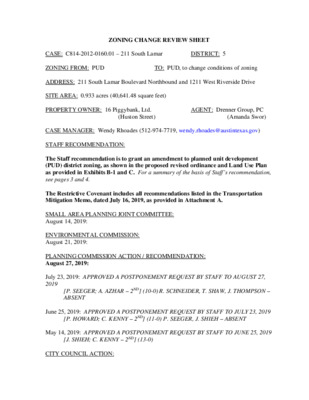
ZONING CHANGE REVIEW SHEET CASE: C814-2012-0160.01 – 211 South Lamar DISTRICT: 5 ZONING FROM: PUD TO: PUD, to change conditions of zoning ADDRESS: 211 South Lamar Boulevard Northbound and 1211 West Riverside Drive SITE AREA: 0.933 acres (40,641.48 square feet) PROPERTY OWNER: 16 Piggybank, Ltd. AGENT: Drenner Group, PC (Huston Street) (Amanda Swor) CASE MANAGER: Wendy Rhoades (512-974-7719, wendy.rhoades@austintexas.gov) STAFF RECOMMENDATION: The Staff recommendation is to grant an amendment to planned unit development (PUD) district zoning, as shown in the proposed revised ordinance and Land Use Plan as provided in Exhibits B-1 and C. For a summary of the basis of Staff’s recommendation, see pages 3 and 4. The Restrictive Covenant includes all recommendations listed in the Transportation Mitigation Memo, dated July 16, 2019, as provided in Attachment A. SMALL AREA PLANNING JOINT COMMITTEE: August 14, 2019: ENVIRONMENTAL COMMISSION: August 21, 2019: PLANNING COMMISSION ACTION / RECOMMENDATION: August 27, 2019: July 23, 2019: APPROVED A POSTPONEMENT REQUEST BY STAFF TO AUGUST 27, 2019 [P. SEEGER; A. AZHAR – 2ND] (10-0) R. SCHNEIDER, T. SHAW, J. THOMPSON – ABSENT June 25, 2019: APPROVED A POSTPONEMENT REQUEST BY STAFF TO JULY 23, 2019 [P. HOWARD; C. KENNY – 2ND] (11-0) P. SEEGER, J. SHIEH – ABSENT May 14, 2019: APPROVED A POSTPONEMENT REQUEST BY STAFF TO JUNE 25, 2019 [J. SHIEH; C. KENNY – 2ND] (13-0) CITY COUNCIL ACTION: C14-2012-0160.01 Page 2 August 8, 2019: June 20, 2019: APPROVED A POSTPONEMENT REQUEST BY STAFF TO AUGUST 8, 2019. VOTE: 11-0. ORDINANCE NUMBER: ISSUES: The Owner and the Bridges on the Park Condominium Association, Inc. have amended the Covenants, Conditions and Restrictions on the subject property, a document recorded on June 11, 2019. Please refer to Supplemental Information section of this report. CASE MANAGER COMMENTS: The proposed amendment to the 211 South Lamar PUD contains a vacant restaurant (limited) use and is located at the southeast corner of South Lamar Boulevard and West Riverside Drive. Land uses surrounding the PUD consist of Lake Bird Lake and the Pfluger Bridge to the north (P), a City-owned pitch and putt golf course across Lee Barton Drive to the east (P), condominiums, a professional office and retail to the south (CS; CS-H, CS-1), and a theater, City offices, a restaurant (limited) and a mixed use development across Lamar Boulevard to the west (P; CS-1, CS-V). Please refer to Exhibits A and A-1 – Zoning Map and Aerial Exhibit. The Applicant proposes to amend the PUD approved by Council in October 2013 to alter the building configuration; remove the requirement for parking at grade (all parking would be underground); and to allow hotel as a permitted land use. The proposed project would permit the construction up to 27 residential units, 108 hotel rooms, and 18,000 sf of non-residential, non-hotel ground floor space. Please note that other than the added use of hotel-motel, no changes are proposed to the maximum 96-foot height limit, the two notes shown on page 2 of the Land Use Plan, or the Open Space and Parkland, Environmental, Water Quality, Public Facilities or Art components of the adopted PUD ordinance. Please refer to Exhibit B and C – Proposed Revisions to the 2013 PUD Ordinance and Land Use Plan. The proposed modifications to the PUD ordinance and accompanying land use plan are summarized below: - Places the parking garage entirely below grade - Includes a U-shaped design for the hotel-motel to accommodate a ground-level courtyard and drop-off / pick-up area - Changes the west (first) building block to move the maximum 96-foot height further from (west of) Lee Barton Drive (from 40 – 48 feet, to 56 feet) - Increases the height of the (second) east building block from 78 to 86 feet - Increases the setback along the southern property line (adjacent to the Bridges on the Park Condominiums) from 7 ½ to 11 feet - Updates the use of the historic Paggi House to office and implements accessibility measures during project construction C14-2012-0160.01 Page 3 - Reduces the number of residential units from 175 to 27, adding a maximum of 108 hotel rooms and increasing non-residential, non-hotel space from 11,000 to 18,000 sf - Adds a provision requiring all new perimeter trees to be installed with a minimum of 1,000 cubic feet of soil volume (with sharing provisions between trees) and a minimum 3’ soil depth - Updates the Affordable Housing Program to meet or exceed current PUD regulations, with participation by either providing onsite units or paying a fee-in-lieu - Adds sections requiring funding for the transportation improvements outlined in Attachment A, prior to final Council approval of the PUD amendment or construction of the improvements prior to issuance of any Certificate of Occupancy - Adds language requiring the Owner to construct 100% of the Corridor Bond Improvements along the property’s Lamar and Riverside frontages, in accordance with the improvements identified in the adopted plan - Removes on-street parking from Lee Barton Drive - Reduces the daily vehicle trip limit from 3,335 to 2,320 - On a southern portion of the South Lamar frontage, redefines the 100’ Point as the 90’ Point (defined as the point 90 feet north of the Property’s southwestern corner on Lamar) (refer to exhibit in Supplemental Information section of this report) - Removes portions of the ordinance, related land use plan and code modifications that are not applicable to the proposed hotel, residential and retail project - Building construction using a purple pipe system to receive reclaimed water supply from the City for non-potable water uses, and extension of the future reclaimed line along the West Riverside Drive frontage. BASIS OF STAFF RECOMMENDATION: 1. The proposed zoning should be consistent with the purpose statement of the district sought. Per the Land Development Code, the Planned Unit Development (PUD) zoning district has been established to implement the goals of preserving the natural environment, encouraging high quality development and innovative design, and ensuring adequate public facilities and services. The City Council intends PUD district zoning to produce development that achieves these goals to a greater degree than and that is therefore superior to development under conventional zoning and subdivision regulations. The proposed PUD amendment still offers a development on the subject property that can create a distinct space that complements the Zach Theatre and gateway to the area south of Lady Bird Lake. The PUD provides pedestrian-oriented uses on the ground floor, upper story hotel and residential uses, underground vehicular parking, charging stations for electric vehicles, landscaping with 100% native and adapted plants, rainwater harvesting, and a purple pipe system to receive reclaimed water supply from the City. In addition, the proposed PUD amendment supports affordable housing initiatives, continues the usability of the historic structure, preserves onsite and offsite trees, provides for offsite pedestrian improvements, provides a space onsite for the City of Austin Parks and Recreation Department and community meeting space, contains a public plaza with art, a 3-star rating under the Austin Green Building program, and will C14-2012-0160.01 Page 4 provide additional bike parking for patrons and residents, and provide a public bike share kiosk. 2. Zoning should promote the policy of locating retail and more intensive zoning near the intersections of major arterials and major collectors. 3. Zoning should allow for a reasonable use of the property. The site is bounded by two major arterials and a collector, and there are mixed use projects, being developed throughout Austin on major arterials, including Lamar Boulevard and Riverside Drive. The proposed PUD amendment involves a change in land use from a primarily residential project to one that reduces the number of residential units, adds hotel use, increases the amount of non-residential square footage, and requires underground parking. Since the original PUD’s approval in 2013, a Corridor Planning Office has been established and plans adopted that requires new development on certain major corridors including South Lamar to implement street improvements identified in the adopted plans and related bond projects. Similarly, Code revisions have enhanced the affordable housing provisions for PUDs, and the proposed project will comply with or exceed the current regulations. Many of the remaining modifications are the result of negotiations between the Applicant and the adjacent condominium ownership for a hotel, residential and commercial use project. EXISTING ZONING AND LAND USES: ZONING LAND USES Site PUD Restaurant (vacant) North P COA Park and Pfluger Pedestrian Bridge Landing South CS; CS-H; CS-1 Condominiums; Professional Office; Retail East P COA Parkland (Pitch and Putt golf course) West P; CS-1; CS-V; CS COA Park, PARD Headquarters, Zach Theatre; Schlotzky’s restaurant (currently proposed as a PUD); Mixed use development NEIGHBORHOOD PLANNING AREA: South Lamar Combined (Zilker) – Suspended TRANSPORTATION MITIGATION: Is required – Please refer to Attachment A WATERSHED: Lady Bird Lake – Urban WATERFRONT OVERLAY: Yes, Butler Shores Subdistrict (Property is outside of primary and secondary setbacks) CAPITOL VIEW CORRIDOR: No SCENIC ROADWAY: West Riverside Drive CORE TRANSIT CORRIDORS: West Riverside Drive and South Lamar Boulevard C14-2012-0160.01 Page 5 SCHOOLS: Zilker Elementary School O. Henry Middle School Austin High School NEIGHBORHOOD ORGANIZATIONS: 57 – Old Austin Neighborhood Association 107 – Zilker Neighborhood Association 127 – Bouldin Creek Neighborhood Association 498 – South Central Coalition 511 – Austin Neighborhoods Council 742 – Austin Independent School District 943 – Save Our Springs Alliance 1074 – Bouldin Creek Neighborhood Planning Team 1107 – Perry Grid 614 1228 – Sierra Group, Austin Regional Group 1368 – Bridges on the Park 1363 – SEL Texas 1424 – Preservation Austin 1528 – Bike Austin 1530 – Friends of Austin Neighborhoods 1550 – Homeless Neighborhood Association 1571 – Friends of Zilker 1596 – TNR BCP - Travis County Natural Resources 1616 – Neighborhood Empowerment Foundation AREA CASE HISTORIES: NUMBER REQUEST COMMISSION CITY COUNCIL C814-2018-0121 – 218 S. Lamar (Schlotzky’s) CS-V to PUD Scheduled for August 27, 2019 To be Scheduled C14-2008-0060 – Zilker Vertical Mixed Use Building (V) Rezoning Opt-In/Opt Out Process – Lady Bird Lake on the north, UPRR tracks, W Oltorf St, S Lamar Blvd to the east, Barton Skyway to the south, and Robert E Lee Rd, Rabb Rd and Rae Dell Ave to the west Rezoning selected tracts with –V and amending the boundary to exclude certain tracts, on 124 acres Apvd –V to certain tracts (73 acres), exclude certain tracts (51 acres), and an affordability level of 60% mfi for 10% of rental units in a VMU building Apvd (10-16-2008). C14H-76-004 – Landmarks Committee – 200 Lee Barton Rd C, First Height and Area to C-H, First Height and Area on an 18,000 sf tract of land To Grant Apvd (11-21-1974). C14-2012-0160.01 Page 6 RELATED CASES: On October 17, 2013, Council approved PUD district zoning for the subject Property, sometimes referred to as the Taco PUD. As a summary, the PUD allowed up to 96 feet in height, required development standards and design characteristics for buildings or structures greater than 60 feet; required at least 1,000 sf of first floor retail space for PARD on a ‘rent- free’ basis for 25 years, required a local business component at a reduced rental rate; addressed parking and access for the historic Paggi House; limited the number of residential units and non-residential ground floor space; required a public plaza onsite and a minimum amount of open space; established environmental and water quality standards; required a minimum 250 sf room for meeting space; established an affordable housing program; required pedestrian improvements, bicycle facilities and ground floor structured parking; and required provisions for public art. Approved Code modifications were for a minimum of 60% parking requirement, Alternative Equivalent Compliance standards for sidewalks, connectivity and private open space and pedestrian amenities, development of a minimum of 75% of the cumulative frontage with pedestrian-oriented uses and including a restaurant component, a maximum of to 96 feet with modified setbacks, a maximum 5 : 1 F.A.R., equal restaurant and retail parking ratios, and additional permitted and prohibited uses (C814-2012-0160). The property is platted as Lot 1, Block A of the Paggi House Subdivision, a one lot subdivision consisting of 1.155 acres recorded on August 2, 2013 (C8-2012-0122.0A). A revised preliminary plan is in process to create a two lot preliminary (C8-2016-0055.01 – Riverside and Lamar Resubdivision). Please refer to Exhibit D. A site plan is in process for an 8-story mixed use development with a 100+ room hotel, 26 condominiums, retail, restaurant and office uses, including two levels of underground parking (SP-2019-0056C – South Lamar and Riverside Mixed Use). Please refer to Exhibit E. EXISTING STREET CHARACTERISTICS: Name ROW Pavement Classification Sidewalks Bicycle Route Capital Metro (within ¼ mile) South Lamar Boulevard 120 feet MAD 4 Arterial Yes Yes Yes West Riverside Drive 120 feet MAD 4 Arterial Yes Yes Yes Lee Barton Drive 55 feet 30 feet Collector No No No C14-2012-0160.01 Page 7 OTHER STAFF COMMENTS: Comprehensive Planning This PUD amendment case is located on the southeast corner of S Lamar Blvd and W Riverside Drive, and abuts Lee Barton Drive on the eastern edge of the property. The subject property is approximately 0.933 acres in size and is the former location of a fast food restaurant. This case is located within the boundaries of the Zilker Park NP, which does not have an adopted neighborhood plan. Surrounding land uses include Lady Bird Lake and Trail, and Downtown Austin to the north; to the south is a multi-family condo building, a restaurant, retail uses, and the Dougherty Arts Center; to the east is Butler Park; and the west is the Zach Theater, Butler Shores Park, and an office building. Connectivity The site is located within 350 ft. to a public transit stop. Public sidewalks are located along Riverside Drive, and S. Lamar Blvd., but only partially along Lee Barton Drive. The Walkscore for this area is 86/100, Very Walkable, meaning most errands can be accomplished on foot. The site is within 1000 ft. of an existing urban trail. The mobility and connectivity options in this area are excellent. Imagine Austin The Imagine Austin Growth Concept Map, found in the Imagine Austin Comprehensive Plan identifies this section of South Lamar Boulevard and Riverside Drive as Activity Corridors. The property is also located by the Downtown Regional Center. Activity corridors are the connections that link activity centers and other key destinations to one another and allow people to travel throughout the city and region by bicycle, transit, or automobile. Corridors are characterized by a variety of activities and types of buildings located along the roadway — shopping, restaurants and cafés, parks, schools, single-family houses, apartments, public buildings, houses of worship, mixed-use buildings, and offices. To improve mobility along an activity corridor, new and redevelopment should reduce per capita car use and increase walking, bicycling, and transit use. Intensity of land use should correspond to the availability of quality transit, public space, and walkable destinations. Site design should use building arrangement and open space to reduce walking distance to transit and destinations, achieve safety and comfort, and draw people outdoors. The following Imagine Austin policies are applicable to this case: • LUT P1. Align land use and transportation planning and decision-making to achieve a compact and connected city in line with the growth concept map. • LUT P3. Promote development in compact centers, communities, or along corridors that are connected by roads and transit that are designed to encourage walking and bicycling, and reduce health care, housing and transportation costs. Based on this property being located along two Activity Corridors and by a Regional Center, and the Imagine Austin policies referenced above that promotes both mixed use and commercial development, the proposed PUD amendment appears to support the policies of the Imagine Austin Comprehensive Plan. Regarding the amended PARD agreement for space C14-2012-0160.01 Page 8 within this development, this request is out of the scope of the Imagine Austin Comprehensive Plan. C14-2012-0160.01 Page 9 Electric Review The site must comply with safety clearances and setback requirements from the utility criteria manual if underground and/or overhead electrical facilities are present. Impervious Cover The maximum impervious cover allowed by the PUD is based on the CS zoning district previously assigned to this property and is 95%, which is based on the more restrictive zoning regulations. The site plan in process proposes 94.49% impervious cover for the hotel / condominium / retail project and 74.39% impervious cover (no change) for the Paggi House. Environmental The site is not located over the Edwards Aquifer Recharge Zone. The site is in the Lady Bird Lake Watershed of the Colorado River Basin, which is classified as an Urban Watershed by Chapter 25-8 of the City's Land Development Code. Standard landscaping and tree protection will be required in accordance with LDC 25-2 and 25-8 for all development and/or redevelopment. This site is required to provide on-site water quality controls (or payment in lieu of) for all development and / or redevelopment when 8,000 s.f. cumulative is exceeded an on-site control for the two-year storm. Floodplain Review Lot appears to be in WBO 500yr floodplain, however, it also appears that this floodplain is resultant of backwater conditions with the Colorado River. The WSE at xs 877 for the 0.2% chance event is 446.49 ft MSE; per GIS, the lowest elevation on the lot is ~448. FYI: Please note that current floodplain regulations require that Finished Floor Elevations (FFE) of the proposed buildings adjacent to the 100-year floodplain must be one foot greater than the 100-year water surface elevation. City of Austin staff is currently proposing changes to the floodplain regulations to require FFEs be two feet above the current FEMA 500-year floodplain or Atlas 14 100-year floodplain. FFE requirements will be based on current code at time of application. FYI: Our understanding of flood risk in Austin is changing. What is now known as the 500-year floodplain is a good representation of what the 100-year floodplain will be according to a National Weather Service publication called Atlas 14. This could affect the layout of this development/future developments on this site, including the location of drainage easements, buildings, and parking areas. The City will likely be using the current 500-year floodplain as the design floodplain for future site plans and commercial building permit review by the end of 2018. In order to minimize flood risk to our community and better ensure that this lot can C14-2012-0160.01 Page 10 be developed in the future, the City of Austin recommends that you consider the 500-year floodplain as a surrogate for the 100-year floodplain when designing this development. Please contact this reviewer if you have any questions. For this application, Atlas 14 will not have an impact on the review, but be aware that future permits for the site may fall under Atlas 14 regulations depending upon when they are requested. It is likely that by the time construction is complete for this building/subdivision that Atlas 14 will be in effect for Austin thus changing the floodplain in the area and it is recommend that the Applicant and the Applicant’s Engineer discuss flood resiliency and alterations which could be made to plan to reduce the risk of flooding of the proposed development (e.g. elevation of Finished Floors to be above current 500-year floodplain, floodproofing of areas below current 500-year floodplain, utilizing 500-year floodplain in place of the 100-year floodplain, etc.) Austin Water Utility The landowner intends to serve the site with City of Austin water and wastewater utilities. The landowner, at own expense, will be responsible for providing any water and wastewater utility improvements, offsite main extensions, utility relocations and or abandonments required by the proposed land use. Depending on the development plans submitted, water and or wastewater service extension requests may be required. Water and wastewater utility plans must be reviewed and approved by the Austin Water Utility for compliance with City criteria. All water and wastewater construction must be inspected by the City of Austin. The landowner must pay the City inspection fee with the utility construction. The landowner must pay the tap and impact fee once the landowner makes an application for a City of Austin water and wastewater utility tap permit. INDEX OF EXHIBITS TO FOLLOW A: Zoning Map A-1: Aerial Map B and B-1: Applicant’s Summary Letter and Proposed Revisions to 2013 PUD Ordinance C: Proposed Revisions to the Land Use Plan D: Proposed Resubdivision E: Proposed Site Plan INDEX OF ATTACHMENTS TO FOLLOW A: Traffic Mitigation Memo and Mitigation Fee In-Lieu B: Carbon Impact Statement Supplemental Information • Waterfront Overlay – Primary and Secondary Setbacks • Proposed Ground Floor with the 90’ Point Area Dimensioned • Amended and Restated Declaration of Covenants, Conditions and Restrictions with Bridges on the Park Condominium Association, Inc. C14-2012-0160.01 Page 11 Correspondence Received 141161237155710236529111013B51211A8241384111196C814-2012-0160.01MF-5CS-1CS-1-VCS-HPUDPDMU-CURE-CO-HPMF-6-COCS-1CSCS-VP-NPCS-1-VP-NPCS-VCSPCS-1PPLI-CO-NPPCSCS-VCS-VCSP-HPP-NPPDMU-CURE-COP-NPCSCS-VCS-VCS-VPCS-1-NPDMU-CUREP-NPDMU-CODAWSONRDSANDRAMURAIDAWAYW 3RD STBUTLER RDBARTONSPRINGS RDW CESARCHAVEZ STN LAMARBLVDWALTERSEAHOLM DRJOSEPHINE STB R REYNOLDS DRJESSIE STTOOMEY RDW 2ND STS LAMAR BLVD SBS LAMAR BLVD NBW RIVERSIDE DRS LAMAR BLVDW CESAR CHAVEZ STLEE BARTON DRH21H22211 SOUTH LAMAR±This map has been produced by the Communications Technology Management Dept. on behalfof the Planning Development Review Dept. for the sole purpose of geographic reference. Nowarranty is made by the City of Austin regarding specific accuracy or completeness.ZONING CASE#:LOCATION:SUBJECT AREA:GRID:MANAGER:C814-2012-0160.01211 S. LAMAR BLVD.933 ACRESH22WENDY RHOADES1'' = 300'ZONING BOUNDARYCREEK BUFFERPENDING CASE!!!!!!SUBJECT TRACTExhibit A 141161237155710236529111013B51211A8241384111196C814-2012-0160.01MF-5CS-1CS-1-VCS-HPUDPDMU-CURE-CO-HPMF-6-COCS-1CSCS-VP-NPCS-1-VP-NPCS-VCSPCS-1PPLI-CO-NPPCSCS-VCS-VCSP-HPP-NPPDMU-CURE-COP-NPCSCS-VCS-VCS-VPCS-1-NPDMU-CUREP-NPDMU-CODAWSONRDSANDRAMURAIDAWAYW 3RD STBUTLER RDBARTONSPRINGS RDW CESARCHAVEZ STN LAMARBLVDWALTERSEAHOLM DRJOSEPHINE STB R REYNOLDS DRJESSIE STTOOMEY RDW 2ND STS LAMAR BLVD SBS LAMAR BLVD NBW RIVERSIDE DRS LAMAR BLVDW CESAR CHAVEZ STLEE BARTON DRH21H22Copyright nearmap 2015211 SOUTH LAMAR±This map has been produced by the Communications Technology Management Dept. on behalfof the Planning Development Review Dept. for the sole purpose of geographic reference. Nowarranty is made by the City of Austin regarding specific accuracy or completeness.ZONING CASE#:LOCATION:SUBJECT AREA:GRID:MANAGER:C814-2012-0160.01211 S. LAMAR BLVD.933 ACRESH22WENDY RHOADES1'' = 300'ZONING BOUNDARYCREEK BUFFERPENDING CASE!!!!!!SUBJECT TRACTExhibit A - 1 Exhibit B 120.0'PHPH12" REBAR12" REBAR"BURY PRTNRS"12" REBAR"BURY PRTNRS"12" REBAR BEARSN 89°53'42" W | 0.30'PHPHPH12" REBAR12" REBAR "BURY PRTNRS"12" REBAR "BURY PRTNRS"12" REBAR "BURY PRTNRS"L4L5L6L7L8L9L10N18°25'13"E 161.15'L1L2L3S27°31'29"W 332.96'W. RIVERSIDE DRIVEINST. 201300158P.R.T.C.T.120' R.O.W.S. LAMARBOULEVARDINST. 201300158P.R.T.C.T.120' R.O.W.LEE BARTON DRIVEINST. 201300158P.R.T.C.T.55' R.O.W.LOT 1, BLOCK APAGGI HOUSESUBDIVISIONINST. 201300158O.P.R.T.C.T.J.U.A.E.INST. 2013137002O.P.R.T.C.T.D.E.VOL. 11643, PG. 201D.R.T.C.T.D.E.VOL. 11643, PG. 201D.R.T.C.T.STORM SEWER ESMT.VOL. 946, PG. 19D.R.T.C.T.LICENSE AGREEMENTINST. 2006055981O.P.R.T.C.T.SIDEWALK ESMT.INST. 2014152312O.P.R.T.C.T.12 SQUARE FEETR.O.W. DEDICATIONINST. 201300158, P.R.T.C.T.12 SQUARE FEETR.O.W. DEDICATIONINST. 201300158, P.R.T.C.T.N80°15'38"W5.54'N62°28'32"W90.00'BRIDGES ON THE PARK,A CONDOMINIUMINST. 2006117044O.P.R.T.C.T.LOT 1BLOCK A0.9325 ACRESLOT 2,BLOCK A0.2221 ACRES120.0'55.0'Line Data TableLine L1L2L3L4L5L6L7L8L9L10Distance7.17'227.80'6.38'31.75'36.33'48.33'96.56'70.79'11.03'40.69'BearingN62°37'14"ES73°10'45"ES22°49'38"EN60°31'00"WN29°29'00"EN60°31'00"WN17°41'51"EN69°56'44"WN18°43'43"EN71°09'40"W16 PIGGYBANK, LTD.,A TEXAS LIMITED PARTNERSHIPINST. 2014021698O.P.R.T.C.T.JPHLaNdSurveying,Inc200'100'Scale: 1" = 100'0VICINITY MAPNOT TO SCALEJPH JobDrawing No. (see below)2018.069.001 SEC S. Lamar Blvd. & W. Riverside Dr., Lot 1, Paggi House Subdivision, Austin,Travis Co., Tx - Final Plat© 2019 JPH Land Surveying, Inc. - All Rights Reserved785 Lonesome Dove Trail, Hurst, Texas 76054Telephone (817) 431-4971 www.jphlandsurveying.comTBPLS Firm 10019500 10194073 10193867DFW | Austin | AbileneDrafter: MLRevision:2019-05-09 MLRevision:Revision:FLOOD ZONE CLASSIFICATIONThis property lies within ZONE(S) X of the Flood Insurance Rate Mapfor Travis County, Texas and Incorporated Areas, map no.48453C0445J, dated 20160106, via scaled map location and graphicplotting andor the National Flood Hazard Layer (NFHL) Web MapService (WMS) at http:hazards.fema.gov.LEGEND OF ABBREVIATIONSUnited States Survey FeetTexas Coordinate System of 1983, Central ZoneNorth American Vertical Datum of 1988Plat Records of Travis County, TexasOfficial Public Records of Travis County, TexasDeed Records of Travis County, TexasVolumePageInstrument NumberPoint of BeginningPoint of CommencingEasementBuilding LineJoint-use access easementDrainage easementPunch hole in concreteUS.SyFt.TxCS,'83,CZNAVD'88P.R.T.C.T.O.P.R.T.C.T.D.R.T.C.T.VOLPGINSTPOBPOCESMTBLJ.U.A.E.D.E.PHMONUMENTS DATUMS BEARING BASISMonuments are found if not marked MNS or CRS.12" rebar stamped "JPH Land Surveying" setMag nail & washer stamped "JPH Land Surveying" setSite benchmark (see vicinity map for general location)Vertex or common point (not a monument)Coordinate values, if shown, are US.SyFt.TxCS,'83,CZElevations, if shown, are NAVD'88Bearings are based on grid north (TxCS,'83,CZ)TxDOT Right of Way tapered concrete monument.TxDOT Right of Way bronze cap in concrete.TxDOT Right of Way aluminum cap.CRSMNSTBMTYPE ITYPE IITYPE IIISITERESUBDIVISION OFLOT 1, BLOCK APAGGI HOUSE SUBDIVISION1.1546 ACRESPRELIMINARY, THIS DOCUMENT IS NOTTO BE RECORDED FOR ANY PURPOSE.STATE OF TEXAS§COUNTY OF TRAVIS§THAT 16 PIGGYBANK, LTD., A TEXAS LIMITED PARTNERSHIP ACTING BY ANDTROUGH BRIAN FOLEY, OWNER OF LOT 1, BLOCK A, PAGGI HOUSESUBDIVISION A SUBDIVISION OF RECORD UNDER INSTRUMENT NUMBER201300158, OFFICIAL PUBLIC RECORDS OF TRAVIS COUNTY, TEXAS, AND ASCONVEYED TO 16 PIGGYBANK, LTD. BY DEED OF RECORD IN INSTRUMENTNUMBER 2014021698 OF THE OFFICIAL PUBLIC RECORDS OF TRAVIS COUNTY,TEXAS; DOES HEREBY RESUBDIVIDE SAID LOT 1 PURSUANT TO CHAPTER 212OF THE TEXAS LOCAL GOVERNMENT CODE AND CHAPTER 25 OF THE AUSTINCITY CODE IN ACCORDANCE WITH THE ATTACHED PLAT TO BE KNOWN ASRESUBDIVISION OF LOT 1, BLOCK A, PAGGI HOUSE SUBDIVISION, ANDDOES HEREBY DEDICATE TO THE PUBLIC THE USE OF THE STREETS ANDEASEMENTS HEREON, SUBJECT TO ANY EASEMENTS PREVIOUSLY GRANTEDBUT NOT RELEASED.16 PIGGYBANK, LTD., A TEXAS LIMITED PARTNERSHIPBY:_________________________________________________HUSTON STREET16 PIGGYBANK, LTD8300 BIG VIEW DRAUSTIN, TEXAS 78730STATE OF TEXAS(cid:134)(cid:38)(cid:50)(cid:56)(cid:49)(cid:55)(cid:60)(cid:3)(cid:50)(cid:41)(cid:3)(cid:66)(cid:66)(cid:66)(cid:66)(cid:66)(cid:66)(cid:66)(cid:66)(cid:66)(cid:66)(cid:66)(cid:66)(cid:66)(cid:66)(cid:3)(cid:134)BEFORE ME, THE UNDERSIGNED, A NOTARY PUBLIC IN AND FOR THE SAIDCOUNTY AND STATE, ON THIS DAY PERSONALLY APPEARED BRIAN FOLEY,OWNER OF 16 PIGGYBANK, LTD, KNOWN TO ME TO BE THE PERSON WHOSENAME IS SUBSCRIBED TO THE FOREGOING INSTRUMENT ANDACKNOWLEDGED TO ME THAT HE EXECUTED THE SAME FOR THE PURPOSETHEREIN EXPRESSED AND UNDER OATH STATED THAT THE STATEMENTS INTHE FOREGOING CERTIFICATE ARE TRUE.WITNESS UNDER MY HAND AND SEAL THIS ______ DAY OF______________________, 2019.___________________________________NOTARY PUBLIC IN AND FOR THE STATE OF TEXASI, JEWEL CHADD, A REGISTERED PROFESSIONAL LAND SURVEYOR IN THESTATE OF TEXAS, HEREBY STATE, TO THE BEST OF MY KNOWLEDGE ANDBELIEF, THIS DRAWING HEREBY REPRESENTS AN ON-THE-GROUND SURVEYPERFORMED BY ME OR UNDER MY SUPERVISION AND THE PROPERTYCORNERS ARE MARKED AS INDICATED.__________________________________________________________________JEWEL CHADDREGISTERED PROFESSIONALLAND SURVEYOR NO. 5754JEWEL@JPHLS.COMDATE: TBAGENERAL NOTES:1.NO STRUCTURES, INCLUDING BUT NOT LIMITED TO BUILDINGS, FENCES, ORLANDSCAPING SHALL BE ALLOWED IN DRAINAGE EASEMENTS EXCEPT ASAPPROVED BY THE CITY OF AUSTIN.2.THE OWNER SHALL BE RESPONSIBLE FOR INSTALLATION OF TEMPORARYEROSION CONTROL. REVEGETATION AND TREE PROTECTION FOR ELECTRICUTILITY WORK REQUIRED TO PROVIDE ELECTRIC SERVICE TO THIS PROJECT.3.THE OWNER OF THIS SUBDIVISION, AND HIS OR HER SUCCESSORS AND ASSIGNS,ASSUMES RESPONSIBILITY FOR PLANS FOR CONSTRUCTION OF SUBDIVISIONIMPROVEMENTS WHICH COMPLY WITH APPLICABLE CODES AND REQUIREMENTSOF THE CITY OF AUSTIN. THE OWNER UNDERSTANDS AND ACKNOWLEDGES THATPLAT VACATION OR REPLATTING MAY BE REQUIRED, AT THE OWNER'S SOLEEXPENSE, IF PLANS TO CONSTRUCT THIS SUBDIVISION DO NOT COMPLY WITHSUCH CODES AND REQUIREMENTS.4.BY APPROVING THIS PLAT, THE CITY OF AUSTIN ASSUMES NO OBLIGATION TOCONSTRUCT ANY INFRASTRUCTURE IN CONNECTION WITH THIS SUBDIVISION.ANY SUBDIVISION INFRASTRUCTURE REQUIRED FOR THE DEVELOPMENT OF THELOTS IN THIS SUBDIVISION IS THE RESPONSIBILITY OF THE DEVELOPER ANDORTHE OWNERS OF THE LOTS. FAILURE TO CONSTRUCT ANY REQUIREDINFRASTRUCTURE TO CITY STANDARDS MAY BE JUST CAUSE FOR THE CITY TODENY APPLICATIONS FOR CERTAIN DEVELOPMENT PERMITS INCLUDINGBUILDING PERMITS, SITE PLAN APPROVALS ANDOR CERTIFICATES OFOCCUPANCY.5.EROSION AND SEDIMENTATION CONTROLS ARE REQUIRED FOR ALLCONSTRUCTION IN THIS SUBDIVISION PURSUANT TO THE LAND DEVELOPMENTCODE.6.BUILDING SET BACK LINES SHALL BE IN CONFORMANCE WITH THE CITY OFAUSTIN ZONING ORDINANCE REQUIREMENTS.7.AUSTIN ENERGY HAS THE RIGHT TO PRUNE ANDOR REMOVE TREES, SHRUBBERYAND OTHER OBSTRUCTIONS TO THE EXTENT NECESSARY TO KEEP THEEASEMENTS CLEAR. AUSTIN ENERGY WILL PERFORM ALL TREE WORK INCOMPLIANCE WITH CHAPTER 25-8, SUBCHAPTER B OF THE CITY OF AUSTIN LANDDEVELOPMENT CODE.8.THE OWNERDEVELOPER OF THIS SUBDIVISIONLOT SHALL PROVIDE AUSTINENERGY WITH ANY EASEMENT ANDOR ACCESS REQUIRED, IN ADDITION TOTHOSE INDICATED, FOR THE INSTALLATION AND ONGOING MAINTENANCE OFOVERHEAD AND UNDERGROUND ELECTRIC FACILITIES. THESE EASEMENTSANDOR ACCESS ARE REQUIRED TO PROVIDE ELECTRIC SERVICE TO THEBUILDING, AND WILL NOT BE LOCATED SO AS TO CAUSE THE SITE TO BE OUT OFCOMPLIANCE WITH CHAPTER 25-8 OF THE CITY OF AUSTIN LAND DEVELOPMENTCODE.9.THE WATER AND WASTEWATER SYSTEMS SERVING THIS SUBDIVISION MUST BEIN ACCORDANCE WITH THE CITY OF AUSTIN UTILITY DESIGN CRITERIA. THEWATER AND WASTEWATER UTILITY PLAN MUST BE REVIEWED AND APPROVEDBY THE AUSTIN WATER UTILITY. ALL WATER AND WASTEWATER CONSTRUCTIONMUST BE INSPECTED BY THE CITY OF AUSTIN. THE LANDOWNER MUST PAY THECITY INSPECTION FEE WITH THE UTILITY CONSTRUCTION.10.NO LOT SHALL BE OCCUPIED UNTIL THE STRUCTURE IS CONNECTED TO THE CITYOF AUSTIN WATER AND WASTEWATER UTILITY SYSTEM.11.PRIOR TO CONSTRUCTION, EXCEPT DETACHED SINGLE FAMILY ON ANY LOT INTHIS SUBDIVISION, A SITE DEVELOPMENT PERMIT MUST BE OBTAINED FROM THECITY OF AUSTIN.12.ALL STREETS WILL BE CONSTRUCTED TO THE CITY OF AUSTIN STANDARDS.13.THE OWNER OF THE PROPERTY IS RESPONSIBLE OF THE MAINTAININGCLEARANCES REQUIRED BY THE NATIONAL ELECTRIC SAFETY CODE,OCCUPATIONAL SAFETY AND HEALTH ADMINISTRATION (OSHA) REGULATIONS,CITY OF AUSTIN RULES AND REGULATIONS AND TEXAS STATE SLAWSPERTAINING TO CLEARANCES WHEN WORKING IN CLOSE PROXIMITY TOOVERHEAD POWER LINES AND EQUIPMENT. AUSTIN ENERGY WILL NOT RENDERELECTRIC SERVICE UNLESS REQUIRED CLEARANCES ARE MAINTAINED. ALLCOSTS INCURRED BECAUSE OF FAILURE TO COMPLY WITH THE REQUIREDCLEARANCES WILL BE CHARGED TO THE OWNER.14.ALL RESTRICTIONS AND NOTES FROM THE PREVIOUS SUBDIVISION OF PAGGIHOUSE SUBDIVISION, A ONE LOT SUBDIVISION CONSISTING OF 1.155 ACRESACCORDING TO THE PLAT RECORDED UNDER INSTRUMENT NUMBER 201300158,OFFICIAL PUBLIC RECORDS, COLLIN COUNTY, TEXAS, SHALL APPLY.15.ANY RELOCATION OF ELECTRIC FACILITIES SHALL BE AT LANDOWNERS DEVELOPERS EXPENSE.18.THERE ARE NO SLOPES GREATER THAN 15 ON THIS SITE.19.PARKLAND FEES MAY BE REQUIRED PER ORDINANCE 20070621-027, OR ASAMENDED, PRIOR TO APPROVAL OF ANY SITE PLAN IN THIS SUBDIVISION.20.CITY OF AUSTIN POLICIES AND ORDINANCES PROHIBIT THE EXTENSION OFCUSTOMER UTILITY LINES ACROSS PRIVATE SPACE, INCLUDING LOT LINES, TOACCESS UTILITY SERVICE FOR ADJACENT PROPERTY THROUGH CONNECTIONEVEN THOUGH SUCH ADJACENT PROPERTY IS OWNED, CONTROLLED, OROCCUPIED BY THE CUSTOMER. WASTEWATER LINES THAT NOW CROSS LOT LINESWERE PREVIOUSLY INSTALLED WITHIN THE PROPERTY COMPRISING PAGGIHOUSE SUBDIVISION WHEN THE DEVELOPMENT WAS UNDER COMMONOWNERSHIP. THE PRIVATE WASTEWATER LINES PREVIOUSLY INSTALLED WITHINTHIS SUBDIVISION THAT CROSS LOT LINES MUST BE PLACED IN A PRIVATEEASEMENT AND A RESTRICTIVE COVENANT MUST BE RECORDED IN THE OFFICIALPUBLIC RECORDS OF TRAVIS COUNTY, TEXAS THAT OBLIGATES THE OWNER ANDTHEIR SUCCESSORS AND ASSIGNS, TO OPERATE AND MAINTAIN THE PRIVATEWASTEWATER LINES AT THEIR SOLE EXPENSE AND WITHOUT COST OR EXPENSETO THE CITY OF AUSTIN. IN THE EVENT THAT (1) THE PROPERTY IS REDEVELOPEDIN A MANNER THAT INCREASES WASTEWATER SERVICE REQUIREMENTS INEXCESS OF THAT CURRENTLY AVAILABLE TO THE LOTS SO AFFECTED; (2) NEWDEVELOPMENT PROPOSED WITHIN THE PROPERTY, PROPOSED LAND USECHANGES FOR EXISTING STRUCTURES OR CHANGES IN OPERATIONS CONDUCTEDON THE PROPERTY INCREASE WASTEWATER SERVICE REQUIREMENTS IN EXCESSOF THAT CURRENTLY AVAILABLE TO THE LOT(S) SO AFFECTED; (3) ACATEGORICAL DISCHARGER WITHIN THE MEANING OF 40 C.F.R. PART 403PROPOSES TO OCCUPY ONE OR MORE STRUCTURES WITHIN THE SUBDIVISION; OR(4) CHANGES IN FIRE SAFETY, INDUSTRIAL WASTE OR OTHER HEALTH ANDSAFETY REGULATIONS, OR COMPLIANCE WITH FEDERAL OR STATE LAWS ORREGULATIONS REQUIRE A SEPARATE CONNECTION TO CITY WASTEWATERSYSTEMS; THEN (A) ALL LOTS SO AFFECTED MUST RECEIVE WASTEWATERSERVICE FROM THE CITY OF AUSTIN VIA SEPARATE CONNECTION TO CITY OFAUSTIN WASTEWATER SYSTEMS DESIGNED AND INSTALLED IN ACCORDANCEWITH CITY POLICIES, ORDINANCES AND DESIGN CRITERIA, INCLUDING WITHOUTLIMITATION, THE CITY'S PLUMBING CODE, FIRE CODE AND INDUSTRIAL WASTEORDINANCE, AND (B) THE OWNER WILL BE RESPONSIBLE FOR THE PROPERDESIGN AND INSTALLATION OF EACH SUCH SEPARATE CONNECTION TO THECITY'S WASTEWATER SYSTEMS AS WELL AS NEW PRIVATE ON-SITE LINESNECESSARY FOR EACH SUCH SEPARATE CONNECTION TO THE CITY WASTEWATERSYSTEMS AT ITS SOLE EXPENSE AND (C) THE OWNER WILL BE RESPONSIBLE FORSEVERING (CUTTING AND PLUGGING) THE EXISTING PRIVATE WASTEWATERLINES THAT CROSS LOT LINES AT ITS SOLE EXPENSE.THIS SUBDIVISION PLAT IS LOCATED WITHIN THE FULL PURPOSE JURISDICTION LIMITSOF THE CITY OF AUSTIN ON THIS THE _________ DAY OF ___________, 2019, A.D.APPROVED , ACCEPTED AND AUTHORIZED FOR RECORD BY THE DIRECTOR,DEVELOPMENT SERVICES DEPARTMENT, CITY OF AUSTIN, COUNTY OF TRAVIS, THIS THE____________ DAY OF __________________________, 2019, A.D._____________________________________________________DENISE LUCAS, INTERIM DIRECTORDEVELOPMENT SERVICES DEPARTMENTI, DANA DEBEAUVOIR, CLERK OF TRAVIS COUNTY, TEXAS DO HEREBY CERTIFY THATTHE FOREGOING INSTRUMENT OF WRITING AND ITS CERTIFICATE OF AUTHENTICATIONWAS FILED FOR RECORD IN MY OFFICE ON THE ____________ DAY OF _____________, 2019,A.D. AT ________ O'CLOCK ____.M., DULY RECORDED ON THE ___________ DAY OF________________, 2019, A.D. AT ________ O'CLOCK ____.M., PLAT RECORDS OF SAIDCOUNTY AND STATE IN DOCUMENT NUMBER ___________________ OFFICIAL PUBLICRECORDS OF TRAVIS COUNTY.WITNESS MY HAND AND SEAL OF OFFICE OF THE COUNTY CLERK, THE ____________ DAYOF __________________________, 2019, A.D.DANA DEBEAUVOIR, COUNTY CLERK, TRAVIS COUNTY, TEXAS____________________________________________________________DEPUTYENGINEER'S CERTIFICATION:I, Mark T. Burson, am authorized under the laws of the State of Texas, to practice theprofessions of Engineering, and do hereby certify that this plat is feasible from anengineering standpoint and complies with the engineering related portions of the AustinCity Code as amended, and is true and correct to the best of my knowledge.__________________________________________________________________Mark T. BursonP.E. No. 66334tburson@consortinc.comDate: Page 1 of 2 MEMORANDUM Date: July 16, 2019 To: Wendy Rhoades, Zoning Case Manager CC: Dan Hennessey, P.E., Big Red Dog/WGI Eric Bollich, P.E., PTOE, Austin Transportation Department Upal Barua, P.E., P. Eng., PTOE, Austin Transportation Department Reference: 211 S Lamar Blvd (PUD Amendment) – Transpiration Mitigation Memo C814-2012-0160.01 Traffic Impact Analysis: The Austin Transportation Department has reviewed the June 12, 2019 (received February 12, 2019) “211 South Lamar Boulevard Development Transportation Memorandum”, prepared by Wantman Group, Inc. (WGI). The memo identifies additional transportation mitigation to account for the PUD amendment land use changes. Trip Generation: Based on the Institute of Transportation Engineers (ITE) Trip Generation Manual (10th Edition), the development will generate approximately 2,320 unadjusted average daily vehicles trips (ADT) upon build out. The table below shows the trip generation by land uses for the proposed development. Table 1: Unadjusted Trip Generation Proposed Land Use Size 24-HourTwo WayVolumeAM Peak Hour PM Peak Hour Enter Exit Enter Exit Multifamily Housing (Mid-Rise) (211) 26 DU 140 2 8 7 4 Hotel (310) 107 rooms 895 30 20 33 31 Shopping Center (820) 10 ksf 378 6 3 18 20 General Office (710) 1.008 ksf 10 1 0 0 1 Hight Turnover Restaurant (932) 8 ksf 897 44 36 48 30 Total 2,320 83 67 106 86 Attachment A Page 2 of 2 Assumptions: 1.No reductions were assumed in the trip generation. However, based on the land useand access to transit and other modes, the proposed vehicle trip generation isconservatively high.Significant Results: The letter identifies improvements listed in the South Lamar Boulevard Corridor Improvements Plan. A pro-rata share of the cost of the improvements for the intersections of Lamar Blvd. at Barton Springs Road and Riverside Drive was determined based on the developments site trips; results are shown in table 2. Staff Recommendations: 1.The Applicant shall design and construct 100% of the following improvements aspart of their first site development application. No temporary certificate ofoccupancy (TCO) or certificate of occupancy (CO) shall be issued until theconstruction of the identified improvements is complete. Note: Cost estimatesshould not be assumed to represent the maximum dollar value of improvementsthe applicant may be required to construct.a.Corridor Bond Improvement on South Lamar and Riverside Dr. along thedevelopment’s frontage and behind the curb. Constructed to the corridorbond standards.2.Fee in-lieu contribution to the City of Austin shall be made for the improvementsidentified in Table 2, totaling $120,375.00, before third reading.Table 2: Recommended Improvements Location Improvement Cost Pro-Rata Share % Pro-Rata Share $ Developers Requirement South Lamar Blvd. & Riverside Dr. Corridor Bond Improvements $2,400,000.00 3.22% $77,188.00 Fee In-lieu South Lamar Blvd. & Barton Springs Rd. Corridor Bond Improvements $2,200,000.00 1.96% $43,187.00 Fee In-lieu Developments Frontage Corridor Bond Improvements N/A N/A N/A Construction Total $4,600,000.00 N/A $120,375.00 Fee In-lieu If you have any questions or require additional information, please contact me at 512-974-1449.Austin Jones, P.E. Austin Transportation Department INVOICE ATD MITIGATION FEE IN-LIEU DATE: July 16, 2019 TO: Dan Hennessey, P.E. BIG RED DOG/WGI, Applicant CC: Brandi Bradshaw (ATD Cashier) 901 S. Mopac Expressway, Bldg 5, Suite 300, Austin TX 78746 FROM: Austin Jones, P.E. Transportation Development Services Division AMANDA CASE#: C814-2012-0160.01 (211 South Lamar) FDU: 7070-2400-9100-4163 As a condition of approval for the above referenced zoning case, the applicant shall post a transportation mitigation fee to the amount of $120,375.00, with the City of Austin, in accordance with LDC. If you have any questions, please contact Austin Jones at (512) 974-1449. Office Use only: Check: Received by: Project Location and improvement Estimated Cost Developer Share South Lamar Blvd. & Riverside Dr. Corridor Improvements $2,400,000.00 $77,188.00 (3.22%) South Lamar Blvd. & Barton Springs Rd. Corridor Improvements $2,200,000.00 $43,187.00 (1.96%) Total $4,600,000.00 $120,375.00 Attachment B