11 C14-2025-0123 - 7401 Hwy 290 Rezoning; District 8 - Staff Report — original pdf
Backup
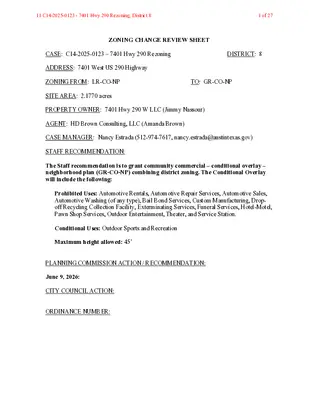
ZONING CHANGE REVIEW SHEET CASE: C14-2025-0123 – 7401 Hwy 290 Rezoning DISTRICT: 8 ADDRESS: 7401 West US 290 Highway ZONING FROM: LR-CO-NP TO: GR-CO-NP SITE AREA: 2.1770 acres PROPERTY OWNER: 7401 Hwy 290 W LLC (Jimmy Nassour) AGENT: HD Brown Consulting, LLC (Amanda Brown) CASE MANAGER: Nancy Estrada (512-974-7617, nancy.estrada@austintexas.gov) STAFF RECOMMENDATION: The Staff recommendation is to grant community commercial – conditional overlay – neighborhood plan (GR-CO-NP) combining district zoning. The Conditional Overlay will include the following: Prohibited Uses: Automotive Rentals, Automotive Repair Services, Automotive Sales, Automotive Washing (of any type), Bail Bond Services, Custom Manufacturing, Drop- off Recycling Collection Facility, Exterminating Services, Funeral Services, Hotel-Motel, Pawn Shop Services, Outdoor Entertainment, Theater, and Service Station. Conditional Uses: Outdoor Sports and Recreation Maximum height allowed: 45’ PLANNING COMMISSION ACTION / RECOMMENDATION: June 9, 2026: CITY COUNCIL ACTION: ORDINANCE NUMBER: 11 C14-2025-0123 - 7401 Hwy 290 Rezoning; District 81 of 27 C14-2025-0123 ISSUES: Page 2 The Applicant’s initial rezoning request was for GR-NP. On May 7, 2026, the Applicant submitted a letter amending the request to include a Conditional Overlay that would prohibit certain uses and establish a maximum building height. On June 2, 2026, the Applicant submitted a second letter amending the request to add additional prohibited uses and one conditional use. Please refer to Attachment A. On May 29, 2026, a letter on behalf of the Oak Hill Baptist Church (“the Church”) was submitted as conditional non-opposition to the proposed rezoning request. The church owns the property immediately south of and adjacent to the rezoning area. CASE MANAGER COMMENTS: The subject rezoning area consists of approximately 2.17 acres and is located at the southwest corner of West US 290 Highway and Convict Hill Road. The property is currently undeveloped and has frontage along both roadways. West US 290 Highway has been reconstructed and widened as part of the TxDOT Oak Hill Parkway project, which also includes the construction of a new intersection at West US 290 Highway and Convict Hill Road. These roadway improvements have changed the transportation context surrounding the property. Surrounding land uses include multifamily residences to the north (MF-2-NP); a religious assembly use and an assisted living facility to the south (LO-CO-NP; GR-CO-NP); a religious assembly use and single family residences are to the east (LO-CO-NP; SF-2-NP); and undeveloped land and a secondary educational facility is to the west (GO-NP). Please refer to Exhibits A (Zoning Map) and B (Aerial Views). At present, there is one access point from the subject property onto Convict Hill Road. This serves as the only point of ingress and egress to the public right-of-way for the Church. TxDOT has approved a second access point along the property’s West US 290 Highway frontage. The applicant is requesting community commercial – conditional overlay – neighborhood plan (GR-CO-NP) combining district zoning to allow for future neighborhood-serving commercial uses. The initial request proposed a coffee shop with a drive-through. However, since the request has been amended, a small center containing personal service uses has also been proposed. Staff is recommending community commercial – conditional overlay – neighborhood plan (GR-CO-NP) combining district zoning. The conditional overlay will prohibit more intensive uses that may not be appropriate for the surrounding neighborhood area. With the reconstruction and widening of West US 290 Highway, the property’s location at the intersection of West US 290 Highway and Convict Hill Road is appropriate for providing 11 C14-2025-0123 - 7401 Hwy 290 Rezoning; District 82 of 27 C14-2025-0123 Page 3 commercial uses along a major arterial roadway. The proposed (GR-CO-NP) zoning is consistent with the surrounding commercial zoning along this corridor and would allow for a range of commercial uses while the conditional overlay limits uses that may not be compatible with the surrounding residential area. BASIS OF RECOMMENDATION: 1. The proposed zoning should be consistent with the purpose statement of the district sought. The community commercial services (GR) district zoning is intended for office and commercial uses serving neighborhood and community needs, including both unified shopping centers and individually developed commercial sites, and typically requiring locations accessible from major traffic ways. The Conditional Overlay (CO) combining district may be applied in combination with any base district. The district is intended to provide flexible and adaptable use or site development regulations by requiring standards tailored to individual properties. The neighborhood plan (NP) district denotes a tract located within the boundaries of an adopted Neighborhood Plan. 2. The rezoning should be consistent with the policies and principles adopted by the City Council. City Council has provided policy and direction for having more intensive uses along major corridors. The proposed (GR-CO-NP) zoning is consistent with the established commercial zoning pattern along this corridor and would provide an appropriate level of commercial intensity for the site. 3. Zoning should promote the policy of locating retail and more intensive zoning near the intersections of arterial roadways or at the intersections of arterials and major collectors. The site is located along West US 290 Highway, a major arterial roadway, an area appropriate for commercial uses due to its proximity and accessibility to a major transportation corridor. Commercial uses would be available to serve residents of the adjacent areas, as well as the broader community. EXISTING ZONING AND LAND USES: ZONING LAND USES LR-CO-NP Undeveloped Site Multifamily residences North MF-2-NP Assisted living facility; Multifamily residences; South LO-CO-NP; GR-CO-NP Religious assembly use LO-CO-NP; SF-2-NP Religious assembly use; Single family residences GO-NP Undeveloped; Secondary Educational Facility East West 11 C14-2025-0123 - 7401 Hwy 290 Rezoning; District 83 of 27 C14-2025-0123 Page 4 NEIGHBORHOOD PLANNING AREA: Oak Hill Combined (West Oak Hill) WATERSHED: Williamson Creek – Suburban CAPITOL VIEW CORRIDOR: No SCENIC ROADWAY: No SCHOOLS: Austin Independent School District Patton Elementary School Small Middle School Austin High School COMMUNITY REGISTRY LIST: Austin Independent School District Covered Bridge Property Owners Association, Inc. Friends of Austin Neighborhoods Legend Oaks II Homeowners Association Oak Hill Neighborhood Plan-COA Liaison Oak Hill Association of Neighborhoods (OHAN) Oak Hill Neighborhood Plan Contact Team Circle C Neighborhood Assn. Estates of LomaVista HOA Ridgeview Oak Hill Trails Association Save Our Springs Alliance AREA CASE HISTORIES: NUMBER C14-2017-0073 – 7100 West US Hwy 290 C14-2011-0146 – 7401 West US Hwy 290 REQUEST GR-CO-NP to GR-MU-CO-NP LO-NP to GR-CO-NP C14-2008-0125 – 7401 West US Hwy 290 (Tract 7) – West Oak Hill NPA West Oak Hill NPA Rezoning from DR to GR-CO-NP RELATED CASES: COMMISSION To Grant GR-MU-CO-NP (7/25/2017) To Grant LR-CO-NP w/ CO to prohibit service station (1/10/2011) GR-CO-NP CITY COUNCIL Apvd GR-MU-CO- NP (8/31/2017). Apvd LR-CO-NP w/ CO to limit vehicle trips/day & prohibit service station (3/21/2013). Apvd GR-CO-NP w/ CO for prohibited uses (1/11/2008). C14-2008-0125 – West Oak Hill NPA – Rezonings to add -NP combining district and change base district zonings on 19 tracts. (Ordinance No. 20081211-097) 11 C14-2025-0123 - 7401 Hwy 290 Rezoning; District 84 of 27 C14-2025-0123 Page 5 ADDITIONAL STAFF COMMENTS: Comprehensive Planning Project Name and Proposed Use: 7401 W US 290 HIGHWAY. C14-2025-0123. Project: 7401 HWY 290 Rezoning. 2.2 acres from LR-CO-NP to GR-NP. Existing: undeveloped. Proposed: coffee shop with drive- through service. Note that applicant seeks the removal of the existing conditional overlay relating to vehicle trip generation and service station use. Yes Y Imagine Austin Decision Guidelines Complete Community Measures * Imagine Austin Growth Concept Map: Located within or adjacent to an Imagine Austin Activity Center, Imagine Austin Activity Corridor, or Imagine Austin Job Center as identified the Growth Concept Map. Names of Activity Centers/Activity Corridors/Job Centers *: • 0.07 miles to Oak Hill Center Activity Center for Redevelopment in Sensitive Environmental Areas Y Mobility and Public Transit *: Located within 0.25 miles of public transit stop and/or light rail station. • Adjacent to bus stops along Convict Hill RD Y Mobility and Bike/Ped Access *: Adjoins a public sidewalk, shared path, and/or bike lane. • Sidewalk present along one side of Convict Hill RD; Bike lane present along Convict Hill RD Connectivity, Good and Services, Employment *: Provides or is located within 0.50 miles to goods and services, and/or employment center. Connectivity and Food Access *: Provides or is located within 0.50 miles of a grocery store/farmers market. Connectivity and Education *: Located within 0.50 miles from a public school or university. Y Connectivity and Healthy Living *: Provides or is located within 0.50 miles from a recreation area, park or walking trail. • 0.5 miles to Convict Hill Quarry Park Connectivity and Health *: Provides or is located within 0.50 miles of health facility (ex: hospital, urgent care, doctor’s office, drugstore clinic, and/or specialized outpatient care.) Housing Choice *: Expands the number of units and housing choice that suits a variety of household sizes, incomes, and lifestyle needs of a diverse population (ex: apartments, triplex, granny flat, live/work units, cottage homes, and townhomes) in support of Imagine Austin and the Strategic Housing Blueprint. Housing Affordability *: Provides a minimum of 10% of units for workforce housing (80% MFI or less) and/or fee in lieu for affordable housing. Mixed use *: Provides a mix of residential and non-industrial uses. Culture and Creative Economy *: Provides or is located within 0.50 miles of a cultural resource (ex: library, theater, museum, cultural center). Culture and Historic Preservation: Preserves or enhances a historically and/or culturally significant site. Creative Economy: Expands Austin’s creative economy (ex: live music venue, art studio, film, digital, theater.) Workforce Development, the Economy and Education: Expands the economic base by creating permanent jobs, especially in industries that are currently not represented in a particular area or that promotes a new technology, and/or promotes educational opportunities and workforce development training. Industrial Land: Preserves or enhances industrial land. Not located over Edwards Aquifer Contributing Zone or Edwards Aquifer Recharge Zone 4 Number of “Yes’s” 11 C14-2025-0123 - 7401 Hwy 290 Rezoning; District 85 of 27 C14-2025-0123 Drainage Page 6 The developer is required to submit a pre- and post-development drainage analysis at the subdivision and site plan stage of the development process. The City’s Land Development Code and Drainage Criteria Manual require that the Applicant demonstrate through engineering analysis that the proposed development will have no identifiable adverse impact on surrounding properties. Environmental This site is not located over the Edwards Aquifer Recharge Zone. The site is in the Williamson Creek Watershed of the Colorado River Basin, which is classified as a Barton Springs Zone Watershed by Chapter 25-8 of the City’s Land Development Code. It is in the Drinking Water Protection Zone. Project applications at the time of this report are subject to the SOS Ordinance that allows <15% impervious cover in the recharge zone> <20% impervious cover in the Barton Creek Watershed> <25% impervious cover in the contributing zone>. According to floodplain maps there is no floodplain within or adjacent to the project location. Standard landscaping and tree protection will be required in accordance with LDC 25-2 and 25-8 for all development and/or redevelopment. At this time, site specific information is unavailable regarding vegetation, areas of steep slope, or other environmental features such as bluffs, springs, canyon rimrock, caves, sinkholes, and wetlands. Under current watershed regulations, development or redevelopment requires water quality control with increased capture volume and control of the 2-year storm on site. Runoff from the site is required to comply with pollutant load restrictions as specified in Land Development Code. At this time, no information has been provided as to whether this property has any preexisting approvals that preempt current water quality or Code requirements. PARD – Planning & Design Review Parkland dedication fees may apply to any future site or subdivision applications resulting from this rezoning. As of January 1, 2024, new commercial, non-residential uses are not subject to parkland dedication requirements at the time of site plan and subdivision. Site Plan FYI: All comments regarding the effects of the proposed rezoning on subsequent Site Plan Review applications are intended to assist in identifying potential development constraints 11 C14-2025-0123 - 7401 Hwy 290 Rezoning; District 86 of 27 C14-2025-0123 Page 7 but do not include all regulations which may affect a specific proposal. Changes to property boundaries and requests for development cannot include all regulatory limitations which may apply to a specific subject to modification or reconsideration if affected by a change in property boundaries or if development is proposed on only a portion of the land proposed for rezoning. These comments are intended to assist in identifying potential development constraints, but do not address the actual restrictions which will apply to a specific development proposal. Austin Development Services offers a variety of pre-application review options to assist in evaluating specific development proposals prior to Site Plan Application. Site plans will be required for any new development except for residential only project with up to 4 units. Any new development is subject to LDC Subchapter E Design Standards and Mixed Use. Additional comments will be made when the site plan is submitted. Compatibility Standards The site is/is not subject to compatibility standards due to the proximity/adjacency of SF-2- NP zoned/used properties to the south and southeast (i.e., the triggering property). Reference 25-2-1051, 25-2-1053 Any structure that is located: a. At least 50 feet but less than 75 feet from any part of triggering property may not exceed 60 feet in height; or b. Less than 50 feet from any part of a triggering property may not exceed 40 Reference 25-2-1061 feet in height. A 25-foot compatibility buffer is required along the property line shared with the triggering property. No vertical structures are permitted in the compatibility buffer. Reference 25-2-1062(B), 25-8-700 An on-site amenity, including a swimming pool, tennis court, ball court, or playground, may not be constructed 25 feet or less from the triggering property. Reference 25-2-1062 Transportation – Engineering Review The adjacent street characteristics table is provided below: Name ASMP Classification ASMP Required ROW Existing ROW Existing Pavement Sidewalks Bicycle Route Convict Hill Road Level 2 – Collector 72’ 84’ 25’ No Yes Capital Metro (within ¼ mile) Yes 11 C14-2025-0123 - 7401 Hwy 290 Rezoning; District 87 of 27 C14-2025-0123 Page 8 W US 290 Hwy Level 5 – Freeway Coord. w/TxDOT 200’ Under Construction Yes Yes Yes A Neighborhood Transportation Analysis (NTA) was required. Please refer to Attachment B. Austin Water Utility No comments on zoning change. The landowner intends to serve the site with existing City of Austin water utilities. Depending on the development plans submitted, water and or wastewater service extension requests may be required. All water and wastewater construction must be inspected by the City of Austin. For more information pertaining to the Service Extension Request process and submittal requirements contact the Austin Water SER team at ser@austintexas.gov. INDEX OF EXHIBITS AND ATTACHMENTS TO FOLLOW: Exhibit A: Zoning Map Exhibit B: Aerial Map Attachment A: Applicant’s 2nd Amendment Letter to rezoning request Applicant’s 1st Amendment letter to rezoning request Applicant’s Initial Summary Letter Attachment B: Neighborhood Traffic Analysis (NTA) Correspondence 11 C14-2025-0123 - 7401 Hwy 290 Rezoning; District 88 of 27 EXHIBIT A 11 C14-2025-0123 - 7401 Hwy 290 Rezoning; District 89 of 27 EXHIBIT B !!!!!!!!!!!!!!!!!!!!!!!!!!!!!!(!(!(!(!(!(!(!(!(!(!(!(!(!(!(!(!(!(!(!(!(!(!(!(!(!(!(!(!(!(!(!(!(!(!(!(!(!(!(!(!(!(!(!(!(!(!(!(!(!(!(!(!(!(!(!(!(!(!(!(!(!(!(!(!(!(!(!(!(!(!(!(!(!(!(!(!(!(!(!(!(!(!(!(!(!(!(!(!(!(!(!(!(!(!(!(!(!(!(!(!(!(!(!(!(!(!(!(!(!(!(!(!(!(!(!(!(!(!(!(!(!(!(!(!(!(!(!(!(!(!(!(!(!(!(!(!(!(!(!(!(!(!(!(!(!(!(!(!(!(!(!(!(!(!(!(!(!(!(!(!(!(!(!(!(!(!(!(!(!(!(!(!(!(!(!(!(!(!(!(!(!(!(!(!(!(!(!(!(!=!>!>!>!>!>C14-2025-0123NPA-2016-0025.02C814-98-0004C814-98-0004.01C14-85-288.135(RCA)C14-2017-0073C14-95-0142C14-06-0228C14-95-0143C14-2011-0146NPA-2011-0025.03C14-95-0141C14-95-0141C14-01-0146C14-96-0072C14-95-0141C14-02-0089C14-91-0036PONCHAPASSWUS290HWYCONVICTHILLRDLACONCHAPASSBREEZYPASSDEBCOEDROAK MEADOW DRWUS290HWYWBWUS290HWYEBTELLURIDETRLWSH71WOLFCREEK PASSSHADOWRIDGE RUNCORRIECVBREEZY PASS CVSILVERDALEDRCLARAMARIECVW US 290 HWY SVRD WBLACONCHACVSNOWBIRDPASSSHADOWRIDGERUNGO-NPRR-NPLO-CO-NPPUD-NPMF-1-NPMF-3-CO-NPMF-2-NPLR-NPMF-3-CO-NPSF-6-NPSF-2-NPGO-CO-NPGR-CO-NPSF-2-NPGR-NPSF-2-NPSF-2-NPSF-2-NPSF-2-NPSF-2-NPSF-4A-NPSF-2-NPGR-MU-CO-NPSF-2-NPSF-3-NPSF-1-NPSF-2-NPSF-2-NPLR-CO-NPGR-NPSF-4A-NPSF-2-NPCS-CO-NPSF-2-NPSF-4A-NPSF-4A-NPSF-2-CO-NPSF-2-NPSF-2-NPLR-MU-CO-NPSF-6-CO-NPSF-3-NPSF-4A-NPSF-1-NPSF-1-NPGR-NPLO-NPSF-1-NP7401 HWY 290 Rezoning±This product has been produced by Austin Planning for the sole purpose of geographic reference. No warranty is madeby the City of Austin regarding specific accuracy or completeness.ZONING CASE#:LOCATION:SUBJECT AREA:MANAGER:C14-2025-01237401 W US 290 Hwy2.2 AcresNancy EstradaCreated: 2/2/2026SUBJECT TRACTZONING BOUNDARY!!!!!PENDING CASECREEK BUFFER1 inch equals 400 '11 C14-2025-0123 - 7401 Hwy 290 Rezoning; District 810 of 27 11 C14-2025-0123 - 7401 Hwy 290 Rezoning; District 811 of 27 ATTACHMENT A 06/02/2026 Lauren Middleton-Pratt City of Austin Planning Department 1000 E 11th St. Austin, TX 78702 Re: Second amendment to rezoning request for C14-2025-0123 located at 7401 W US 290; a 2.17 acre tract of land out of Lot 1 Block 5 of the Oak Hill Heights, section 5 subdivision; TCAD Parcel 315132 (the “Property”) Dear Mrs. Middleton-Pratt: As representatives of the owner of the above stated Property, we respectfully submit a second amendment to the application for rezoning for 7401 W US 290. The Property is currently zoned as Neighborhood Commercial-Conditional Overlay - Neighborhood Plan Combining district (LR-CO-NP). The proposed rezoning is Community Commercial-Conditional Overlay-Neighborhood Plan (GR-CO-NP). The requested CO includes the following: The following uses shall be prohibited: Automotive Rentals Automotive Repair Services Automotive Sales Automotive washing (of any type) Bail Bond Services Custom Manufacturing Drop-Off Recycling Collection Facility The following uses shall be conditional: Outdoor Sports and Recreation The maximum height shall be: The maximum height is 45’ Exterminating Services Funeral Services Hotel-Motel Pawn Shop Services Outdoor Entertainment Service Station Theater If you have any questions regarding this request or need additional information, please do not hesitate to contact me at your convenience. Very truly yours, Amanda Couch Brown 214-695-9219 | AMANDA.BROWN@HDBROWNCONSULTING.COM | HDBROWNCONSULTING.COM 11 C14-2025-0123 - 7401 Hwy 290 Rezoning; District 812 of 27 Lauren Middleton-Pratt City of Austin Planning Department 1000 E 11th St. Austin, TX 78702 05/07/2026 Re: Amended rezoning request for C14-2025-0123 located at 7401 W US 290; a 2.17 acre tract of land out of Lot 1 Block 5 of the Oak Hill Heights, section 5 subdivision; TCAD Parcel 315132 (the “Property”) Dear Mrs. Middleton-Pratt: As representatives of the owner of the above stated Property, we respectfully submit an amendment to the application for rezoning for 7401 W US 290. The Property is currently zoned as Neighborhood Commercial-Conditional Overlay - Neighborhood Plan Combining district (LR-CO-NP). The proposed rezoning is Community Commercial-Conditional Overlay-Neighborhood Plan (GR-CO-NP). The requested CO includes the following: The following uses shall be prohibited: Automotive Repair Services Automotive Rentals, Automotive Sales, Automotive washing allowed as a secondary application only, Bail Bond Services, Custom Manufacturing, Pawn Shop Services, Exterminating Services, and Outdoor Entertainment The maximum height shall be: The maximum height is 45’ If you have any questions regarding this request or need additional information, please do not hesitate to contact me at your convenience. Very truly yours, Amanda Couch Brown 214-695-9219 | AMANDA.BROWN@HDBROWNCONSULTING.COM | HDBROWNCONSULTING.COM 11 C14-2025-0123 - 7401 Hwy 290 Rezoning; District 813 of 27 Lauren Middleton-Pratt City of Austin Planning Department 1000 E 11th St. Austin, TX 78702 Via Electronic Submittal Re: Rezoning request for 7401 W US 290; a 2.17 acre tract of land out of Lot 1 Block 5 of the Oak Hill Heights, section 5 subdivision; TCAD Parcel 315132 (the “Property”) Dear Mrs. Middleton-Pratt: As representatives of the owner of the above stated Property, we respectfully submit an application for rezoning for 7401 W US 290. The Property is undeveloped and is currently zoned as Neighborhood Commercial-Conditional Overlay - Neighborhood Plan Combining district (LR-CO-NP). The proposed rezoning is Community Commercial-Neighborhood Plan (GR-NP). The purpose of this rezoning is to allow for a coffee shop with drive-through service, which is not a per- mitted use in the LR district under LDC § 25-2-587 and LDC § 25-2-809. Additionally, the request in- cludes removal of the existing CO (Ord. No. 20130321-058), which currently limits development on the Property as follows: 1. A site plan or building permit may not be approved if the development generates traffic that exceeds 2,000 adjusted vehicle trips per day; and 2. A service station use is a prohibited use of the Property. The Property is situated at the southwest corner of Convict Hill Rd and US 290. Since adoption of the existing zoning in 2013, TxDOT’s Oak Hill Parkway Project has been completed, transforming this portion of US 290 into a six-lane, divided highway with continuous frontage roads. These improvements have substantially increased capacity, access, and visibility along the corridor. These upgrades have changed site conditions such that the existing CO restrictions are no longer compatible with the transportation and access conditions. The Property is within the Oak Hill Combined Neighborhood Plan and designates this site as “Commercial” which allows for a GR base zoning designation. Therefore, a FLUM is not required. If you have any questions regarding this request or need additional information, please do not hesitate to contact me at your convenience. Very truly yours, Amanda Couch Brown 214-695-9219 | AMANDA.BROWN@HDBROWNCONSULTING.COM | HDBROWNCONSULTING.COM 11 C14-2025-0123 - 7401 Hwy 290 Rezoning; District 814 of 27 ATTACHMENT B MEMORANDUM To: CC: From: Date: Subject: Amanda Brown, HD Brown Consulting Danielle Morin, AICP; Juan Valera, P.E., ATPW Nazlie Saeedi P.E., ATPW March 10th, 2026 7401 US 290 NTA | C14-2025-0123 The purpose of this memorandum is to provide an overview of the proposed development and present the findings of the Neighborhood Tra.ic Analysis (NTA) conducted by Austin Transportation and Public Works (ATPW). The proposed development includes a 2,800 SF Fast Food Restaurant with a drive-through window. The site is a 2.177-acre tract located at 7401 US 290 as shown in Figure 1 below. The site is currently zoned LR-CO-NP and the applicant is looking to rezone to GR- NP. The site proposes access to US 290, which is a level 5 road, and Convict Hill Rd, which is a level 2 road. Roadways Figure 1: Site location Convict Hill Rd: The Austin Strategic Mobility Plan (ASMP) designates Convict Hill Rd as a Level 2 road. The pavement width varies from approximately 40 feet to 48 feet. There are two travel lanes, undivided, with striped bike lanes, street parking on one side, and sidewalk on both sides for the majority of the length. It has a posted speed limit of 35 mph. According to the ASMP, the required 11 C14-2025-0123 - 7401 Hwy 290 Rezoning; District 815 of 27 Date: Subject: March 10th, 2026 7401 US 290 NTA | C14-2025-0123 right-of-way of Convict Hill Rd in the vicinity of the site is 72 feet. Trip Generation and Tra.ic Analysis Based on the Institute of Transportation Engineer’s Trip Generation Manual, 11th Edition, the proposed development will generate 1,309 vehicle trips per day. The existing site is vacant. See Table 1 for a detailed breakdown of the existing and proposed land uses and trip generation. Table 1: Proposed Daily Trip Generation Land Use Type Fast-Food Restaurant with Drive- Through Window ITE Code 934 Units Daily Trip Generation (vpd) 2,800 SF 1,309 24-hour tra.ic volumes were collected at two points, see Figure 2 below, on Convict Hill Rd, on November 18, 19, and 20th, 2025. An average of both locations was taken to get the existing count along Convict Hill Rd. Figure 2: Tube count locations Table 2 provides the expected trip distribution for the proposed land use. This development proposes access to US 290 and Convict Hill Rd. It has been assumed 70% of the site tra.ic will access the site via US 290 and 30% of the site tra.ic will access the site via Convict Hill Rd. Page 2 of 4 11 C14-2025-0123 - 7401 Hwy 290 Rezoning; District 816 of 27 Date: Subject: March 10th, 2026 7401 US 290 NTA | C14-2025-0123 Table 2: Trip Distribution Street Estimated Trip Distribution (Percentage) Estimated Trip Distribution (vpd) Convict Hill Rd 30% 393 Table 3 represents a breakdown of tra.ic along Convict Hill Rd: existing tra.ic, proposed site tra.ic and total tra.ic after development. Table 3: Trip Summary Street Pavement Width Existing Tra.ic from Counts (vpd) Site Tra.ic added to Roadway (vpd) Convict Hill Rd 40-48’ 6,110 393 Total Future Tra.ic (vpd) 6,502 According to Section 25-6-116 of the Land Development Code (LDC), residential local or collector streets that are 40 feet or wider of pavement width are operating at a desirable level if the average daily traf%ic volume for such a roadway does not exceed 4,000 vehicles per day. Based on the LDC criteria, existing traf%ic volume(s) exceed(s) the LDC’s desirable volume thresholds for Convict Hill Rd, and the addition of traf%ic generated by the proposed development is expected to exceed the LDC’s desirable volume thresholds. However, the combined traf%ic from the proposed development and existing vehicles will not exceed the roadway's capacity. This capacity is determined by standard transportation engineering principles and the residential street capacity levels outlined in the nationally recognized Highway Capacity Manual (HCM). Recommendations and Conclusions Based on the results of the NTA, Austin Transportation and Public Works (ATPW) has the following recommendations and conclusions: 1. The Austin Strategic Mobility Plan (ASMP) recommends improvements to bicycle and pedestrian facilities along Convict Hill Rd, including a protected bike lane. 2. Per the ASMP, the required ROW for Convict Hill Rd adjacent to the site is 72ft. 3. If the number of units proposed in Table 1 is exceeded, the TDS division may be required to reassess the NTA. 4. This site will be subject to Street Impact Fee (SIF), which will help fund roadway capacity projects identified in RCP necessitated by new developments. The SIF calculation shall be performed during the Site Plan review, and the fee will be collected at the time of building permit application. For more information on Impact Fees, please visit the City’s SIF website (https://www.austintexas.gov/department/street-impact-fee). Page 3 of 4 11 C14-2025-0123 - 7401 Hwy 290 Rezoning; District 817 of 27 Date: Subject: March 10th, 2026 7401 US 290 NTA | C14-2025-0123 5. This assessment is based on the proposed uses, intensity, and access. Any changes in these assumptions may require an updated NTA. 6. This NTA does not grant nor guarantee approval of proposed driveway types or locations. Driveway types and locations will be reviewed with the site plan application. Please contact me at nazlie.saeedi@austintexas.gov if you have any questions or require additional information. Sincerely, Nazlie Saeedi, P.E. Austin Transportation & Public Works Page 4 of 4 11 C14-2025-0123 - 7401 Hwy 290 Rezoning; District 818 of 27 May 29, 2026 VIA E-MAIL AND U.S. MAIL Austin Planning and Zoning Department Attn: Nancy Estrada Permitting and Development Center 6310 Wilhelmina Delco Drive Austin, Texas Re: Conditional Non-Opposition to Proposed Zoning Change from LR-CO-NP to GR-NP for property located at 7401 West US 290 Hwy (the “Property”) and owned by 7401 Hwy. 290 W LLC; Case Number C14-2025-0123 Dear Nancy: Our firm represents Oak Hill Baptist Church (the “Church”), the owner of the tract immediately adjacent to the Property on the southern property line. The Church holds a recorded appurtenant access easement that traverses the Property and connects the Church’s property to Convict Hill Drive (the “Easement”) and constitutes its only improved, routinely usable point of ingress and egress to a public roadway, although the Church also has a separate easement to Highway 290 that is only a grass two-track and is not suitable for regular, safe, all-weather access. We submit this letter to state that the Church will not oppose the proposed rezoning of the Property from LR-CO-NP (Neighborhood Commercial District with Conditional Overlay and Neighborhood Plan) to GR- NP (Community Commercial District with Neighborhood Plan) only if the rezoning ordinance, any conditional overlay, and any related site-plan approvals incorporate the limitations and conditions stated in this letter; absent those enforceable conditions, the Church formally protests the proposed rezoning. Any approval of the requested up-zoning must be conditioned on the applicant not using or modifying the Easement for project access, and not obtaining site-plan approval, building permits, or commencing development, unless and until a revised easement agreement acceptable to the Church has been fully executed and recorded as described below. Without an appropriate, fully executed, and recorded amendment to the Easement agreement acceptable to the Church, using the Easement as a project driveway would materially impair and unreasonably interfere with the Church’s use and enjoyment of its property and its access rights, would overburden the Easement beyond what was contemplated when granted, and would create unacceptable safety hazards for parishioners, students, children, food-pantry recipients and volunteers, delivery vehicles, and visitors entering, exiting, or using the Church property, particularly during Wednesday and Sunday peak periods, 1001 S. Capital of Texas Hwy, Bldg L, Suite 250 Austin, TX 78746 | www.grablemartin.com 11 C14-2025-0123 - 7401 Hwy 290 Rezoning; District 819 of 27 weekday children’s activities, baseball activities, food-pantry intake and distribution periods, and special events. The Easement benefits the Church and exists to provide the Church with ingress and egress to Convict Hill Drive. The Church has no other improved access point to any public road and relies on the Easement for regular, safe, all-weather access to its property, because its separate Highway 290 easement is only a grass two-track that is not suitable for routine Church, school, event, emergency, delivery, or food-pantry traffic, a condition known to the Property owner and applicant. When the Easement was initially granted, it was not granted to provide independent commercial access to a separate, higher-intensity development on the servient estate, and no language in the recorded easement instruments authorizes such use. Repurposing the Easement as the primary commercial driveway, or allowing materially more than the limited shared access represented by the applicant, would fundamentally change the character and intensity of use, introducing materially higher trip volumes, queuing, truck deliveries, ride-hailing activity, and conflict points within the easement corridor and at its intersection with Convict Hill Drive, resulting in a substantial adverse effect on public safety and on the Church’s protected access rights. The existing Easement corridor and driveway throat were not designed or constructed to function as a community-commercial access facility. Staff should expect increased vehicle trips associated with GR-NP entitlements to overwhelm the driveway’s capacity, causing spillback, dangerous weaving, and sight- distance challenges that materially degrade levels of service and emergency access. These conditions will be most acute when parishioners, students, children, food-pantry recipients and volunteers, delivery vehicles, and visitors congregate, including Sundays, Wednesday evenings, weekday afternoons and evenings, baseball activities, food-pantry intake and distribution periods, and special events, when pedestrian activity, turning movements, delivery traffic, and queuing are heaviest. The proposed use of the Property and projected site plan raises unresolved questions about who will be responsible for ongoing maintenance, repairs, capital upgrades, weather treatment, lighting, signage, and traffic control within the Easement area and at the Convict Hill Drive intersection. Without a recorded, Church-approved easement amendment or agreement, executed and recorded before any site-plan approval, building permit, or commencement of development, allocating maintenance, repair, capital-improvement, traffic-control, indemnity, insurance, and restoration obligations, the City would be enabling a development that relies on a privately held access right without any enforceable framework to protect the Church or the public. The Church’s Easement would be burdened with costs, expenses, and maintenance that far exceed those currently needed to maintain the Easement drive and to provide a safe entry and exit point. Granting GR-NP here without enforceable conditions would be inconsistent with the public interest because it encourages site access that degrades safety for a sensitive use—a house of worship, school-related facility, children’s activity area, community gathering place, and food pantry serving approximately 100 families and individuals each week and distributing more than 3,000 pounds of food weekly in the Oak Hill area. It also runs counter to the neighborhood plan’s goals of compatible transitions and safe multimodal access. Where an up-zoning depends upon commandeering a private religious institution’s access easement for commercial traffic, the impact on safety and compatibility is substantial and adverse. GRABLE MARTIN Page 2 11 C14-2025-0123 - 7401 Hwy 290 Rezoning; District 820 of 27 For these reasons, the Church respectfully requests that the Planning and Zoning Commission and City Council only approve the requested rezoning of the Property from LR-CO-NP to GR-NP if there are binding conditions acceptable to the Church placed upon the Property. At a minimum, the Church’s non-opposition is conditioned on the following being incorporated into the rezoning ordinance, conditional overlay, restrictive covenant, site-plan conditions, and a recorded Church-approved easement amendment, as applicable: (i) a professional traffic impact analysis, including Sunday, Wednesday, weekday-afternoon, baseball, school/activity, food-pantry intake and distribution, delivery, and special-event peak conditions, confirms no degradation to safety or operations for Church access; (ii) the applicant executes and records, to the Church’s satisfaction and before site-plan approval, building permits, or commencement of development, an easement amendment that clearly defines permitted use, requires a perpendicular access point from the main drive to the applicant’s site with stop-control yielding to Church traffic, imposes hours/vehicle-type/delivery/queuing controls, assigns full maintenance, repair, capital improvement, traffic-control, lighting, signage, weather-treatment, and restoration responsibility, and provides robust indemnity, additional insured status, and insurance requirements; (iii) primary customer and delivery access must be directed to US 290, with enforceable signage, site design, and traffic-control measures to discourage project traffic from using Convict Hill Drive and the Easement except as expressly permitted in the recorded easement amendment; (iv) building coverage and impervious cover may not exceed the limits applicable under the current LR zoning, including no more than 80% impervious cover; (v) maximum building height may not exceed 45 feet; (vi) the ordinance must prohibit the uses on the Property which are described on Annex 1 attached hereto; (vii) the applicant must repair the rock wall at the entryway; and (viii) the applicant must install and maintain privacy fencing and screening along the southern property line adjacent to the Church where necessary to protect children, parishioners, students, food-pantry recipients and volunteers, and visitors from commercial activity and traffic conflicts. Nothing in this conditional non-opposition, and no participation in discussions with the applicant or City, waives, limits, or prejudices the Church’s property rights or remedies, including the right to withdraw its non-opposition if the conditions above are not adopted and enforced and the right to pursue declaratory and injunctive relief to prevent unauthorized or overburdening use of the Easement and to recover damages resulting from any interference. Please include this letter in the administrative record for the case, treat the Church’s non-opposition as expressly contingent on adoption and enforcement of the conditions stated above, and provide notice of all hearings, staff recommendations, draft ordinances, conditional overlays, restrictive covenants, site-plan submissions, and proposed easement documents to the undersigned before any action is taken. Sincerely, Michael N. Blue, Esq. Grable Martin PLLC mblue@grablemartin.com Counsel for Rob Satterfield and Oak Hill Baptist Church GRABLE MARTIN Page 3 11 C14-2025-0123 - 7401 Hwy 290 Rezoning; District 821 of 27 ANNEX 1 Prohibited Uses 1. Automotive Repair Services 2. Automotive Rentals 3. Automotive Sales 4. Automotive washing, except as an accessory use only if expressly permitted under the current LR zoning limitations and approved in writing by the Church 5. Bail Bond Services 6. Custom Manufacturing 7. Pawn Shop Services 8. Exterminating Services 9. Drop-Off Recycling Collection Facility 10. Funeral Services 11. Hotel-Motel 12. Theater 13. Outdoor Entertainment 14. Service Stations beyond what is permitted under LR In addition to the prohibited uses set forth above, the following should be prohibited from being offered or sold at the property: alcohol sales, smoke/vape/THC/cannabis sales, adult-oriented businesses, and any outdoor amplified or late-night use that creates material noise or has a negative safety impact on the Church. 11 C14-2025-0123 - 7401 Hwy 290 Rezoning; District 822 of 27 Nancy Estrada City of Austin Planning Department 1000 E 11th St. Austin, TX 78702 05/08/2026 Re: Postponnment request for C14-2025-0123 located at 7401 W US 290; a 2.17 acre tract of land out of Lot 1 Block 5 of the Oak Hill Heights, section 5 subdivision; TCAD Parcel 315132 (the “Property”) Dear Mrs. Estrada: Please accept this letter as a formal request for postponement for case # C14-2025-0123 from the May 12 Planning Commission hearing to the May 26th Planning Commission hearing. If you have any questions regarding this request or need additional information, please do not hesitate to contact me at your convenience. Very truly yours, Amanda Couch Brown 214-695-9219 | AMANDA.BROWN@HDBROWNCONSULTING.COM | HDBROWNCONSULTING.COM 11 C14-2025-0123 - 7401 Hwy 290 Rezoning; District 823 of 27 11 C14-2025-0123 - 7401 Hwy 290 Rezoning; District 824 of 27 From: Rory Hearse Sent: Sunday, May 10, 2026 4:21 PM To: Estrada, Nancy <Nancy.Estrada@austintexas.gov> Subject: May 12 public hearing, Case C14-2025-0123 External Email - Exercise Caution Case Number: C14-2025-0123 Contact: Nancy Estrada, 512-974-7617 Public Hearing: May 12, 2026, Planning Commission Written Comments: I object Rory Hertzfeld, 7000 Convict Hill Road I am opposing the proposed rezoning from Neighborhood Commercial (LR-CO-NP) to Community Commercial (GR-NP) because this intersection is already compact. The physical layout leaves no margin for additional turning movements or commercial driveways. Neighborhood Commercial zoning is designed for low‑impact uses. Community Commercial zoning allows higher‑volume, regional‑draw businesses that would significantly increase turning movements at peak‑hour traffic — exactly what this intersection cannot handle. Our apartment complex has only one point of egress onto Convict Hill Road. Across from us, the church and the church preschool also have only one point of egress onto Convict Hill Road. With the new 290 Freeway project our single points of access are beside a 12 lane intersection. Between stopped traffic blocking our access to Convict Hill Road and then the cars moving continuously during green lights, there are few safe gaps to exit. Introducing a new commercial driveway would turn this bottleneck into an unsafe choke point. This location cannot absorb more tight traffic. I respectfully urge you to deny the rezoning request. Thank you, Rory Hertzfeld 11 C14-2025-0123 - 7401 Hwy 290 Rezoning; District 825 of 27 From: James.Lee Sent: Tuesday, February 10, 2026 12:09 PM To: Estrada, Nancy <Nancy.Estrada@austintexas.gov> Cc: amanda.brown; JAMES.LEE Subject: Formal Opposition to Case C14-2025-0123: Serious Concerns Regarding Residential Integrity and Safety Importance: High External Email - Exercise Caution Dear Nancy Estrada, My name is James Jinhyoung Lee, and I am the resident and trustee of the property located at 6804 Convict Hill Rd, Austin, TX 78749, which is held under The 2024 Lee Family Trust. My home is situated directly at the corner of Convict Hill Rd and Breezy Pass, the primary entrance to our residential community and immediately across from the proposed project site. I am writing to express my firm opposition to the rezoning application from LR-CO-NP to GR-NP (Case #C14-2025-0123) intended for a restaurant with drive-through service. This development is entirely incompatible with our neighborhood for the following reasons: 1. Critical Traffic and Safety Issues Our area is already under extreme pressure due to the US 290 expansion project. It is already difficult to exit my garage onto Convict Hill Rd. A drive-through facility at this intersection will create intolerable gridlock and significantly increase the risk of accidents at an already dangerous junction. 2. Deterioration of Neighborhood Quality A drive-through restaurant introduces noise pollution (idling cars and speakers), nighttime light pollution, and odors into a quiet residential zone. Such high-intensity commercial use will likely attract increased crime, litter, and potential homeless encampments, threatening the safety of our families and children. Insufficient onsite parking will lead to customers parking on our residential streets, further obstructing traffic and neighborhood access. 3. Direct Economic Impact Establishing a major commercial facility at our neighborhood entrance will devalue my 11 C14-2025-0123 - 7401 Hwy 290 Rezoning; District 826 of 27 property and the surrounding homes. This rezoning prioritizes commercial profit at the direct expense of long-term residents' home equity and quality of life. 4. Zoning and Legal Inconsistency The current LR (Neighborhood Commercial) designation was intended to protect the residential character of the area. The proposed GR (Community Commercial) designation is a severe overreach that violates the intent of our Neighborhood Plan. I urge the City of Austin to deny this application based on its significant negative impacts on public safety and residential integrity. I request that this opposition be formally entered into the public record for Case C14-2025-0123. Sincerely, James Jinhyoung Lee Trustee, The 2024 Lee Family Trust 6804 Convict Hill Rd, Austin, TX 78749 CAUTION: This is an EXTERNAL email. Please use caution when clicking links or opening attachments. If you believe this to be a malicious or phishing email, please report it using the "Report Message" button in Outlook. For any additional questions or concerns, contact CSIRT at "cybersecurity@austintexas.gov". 11 C14-2025-0123 - 7401 Hwy 290 Rezoning; District 827 of 27