13 C14-2025-00125 - Former AISD Brooke ES Redevelopment; District 3 - Staff Report — original pdf
Backup
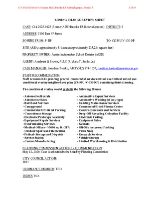
ZONING CHANGE REVIEW SHEET CASE: C14-2025-0125 (Former AISD Brooke ES Redevelopment) DISTRICT: 3 ADDRESS: 3100 East 4th Street ZONING FROM: P-NP TO: CS-MU-V-CO-NP SITE AREA: approximately 5.4 acres (approximately 235,224 square feet) PROPERTY OWNER: Austin Independent School District (AISD) AGENT: Armbrust & Brown, PLLC (Richard T. Suttle, Jr.) CASE MANAGER: Jonathan Tomko, AICP (512) 974-1057, jonathan.tomko@austintexas.gov STAFF RECOMMEDATION: Staff recommends granting general commercial services-mixed use-vertical mixed use- conditional overlay-neighborhood plan (CS-MU-V-CO-NP) combining district zoning. The conditional overlay would prohibit the following 28 uses: - Automotive Rentals - Automotive Sales - Bail Bond Services - Campground - Commercial Off-Street Parking - Convenience Storage - Electronic Prototype Assembly - Equipment Repair Services - Exterminating Services - Medical Offices - >5000 sq. ft. GFA - Outdoor Sports and Recreation - Pedicab Storage and Dispatch - Service Station - Custom Manufacturing - Automotive Repair Services - Automotive Washing (of any type) - Building Maintenance Services - Commercial Blood Plasma Center - Construction Sales and Services - Drop-Off Recycling Collection Facility - Electronic Testing - Equipment Sales - Kennels - Off-Site Accessory Parking - Pawn Shop - Research Services - Vehicle Storage - Limited Warehousing & Distribution PLANNING COMMISSION ACTION / RECOMMENDATION: May 12, 2026: Case is scheduled to be heard by Planning Commission CITY COUNCIL ACTION: TBD ORDINANCE NUMBER: TBD ISSUES: N/A 13 C14-2025-00125 - Former AISD Brooke ES Redevelopment; District 31 of 19 C14-2025-0125 2 CASE MANAGER COMMENTS: The subject tract in question is currently Brooke Elementary School which AISD has identified for redevelopment. It is located at the southeast corner of East 5th Street and Tillery Street which are both ASMP level 2 roadways. The site is located less than 1,000 feet from the proposed green line station where the rail spur meets North Pleasant Valley Road northwest of the site. It is also approximately 1,250 feet south of East 7th Street and approximately 1,000 feet north of East Cesar Chavez, both Imagine Austin Activity Corridors. It is approximately 650 feet east of North Pleasant Valley Road which is also an Imagine Austin Corridor. BASIS OF RECOMMENDATION: Zoning should promote clearly-identified community goals, such as creating employment opportunities or providing for affordable housing. This site is in a highly walkable and bikeable location, with grocery stores, restaurants, parks and educational facilities all within a short walk. A wide variety of daily needs can be reached within a 15-minute walk. The area is also rich in public transit assets including a Metro Rapid Route 800 high frequency bus stop and a proposed Green Line rail stop at Pleasant Valley. It is important to permit a variety of uses compatible with the context of this location. Promoting housing and a mixed-use development in this location would offer more services to existing residents and any housing developed would be more affordable due to the wide variety of transportation options. The rezoning should be consistent with the policies and principles adopted by the City Council or Planning Commission. Rezoning this property proximate to several Imagine Austin Corridors would support the implementation of Imagine Austin by increasing residential density within ¼ mile of several Corridors. Zoning should allow for reasonable use of the property. It is reasonable to expect the property to be redeveloped at a greater intensity than the single- story building at the site today, given the location and proximity to several major corridors. The conditional overlay that staff is proposing prohibits many more intense uses within the zoning base district. There is intensive CS base district zoning along East 5th Street, particularly at corners of major intersections. Zoning is more intense south of East 5th Street, east of Tillery Street, just east of the site. EXISTING ZONING AND LAND USES: Site P-NP ZONING North (across E. 5th St.) P-NP, LO-CO- NP, and SF-3-NP South (across E. 4th St.) SF-3-NP LAND USES A large one-story school of approximately 50,000 square feet. A large three-story office building of approximately 190,000 square feet. Two single family homes of approximately 1,200 square feet. Seven single family homes 13 C14-2025-00125 - Former AISD Brooke ES Redevelopment; District 32 of 19 C14-2025-0125 3 East (across Tillery St.) CS-CO-NP and NO-NP West (across Linden St.) SF-3-NP One industrial warehouse with 10 bays, of approximately 20,000 square feet. A radio tower on approximately 2.5 acres of land. One single family home and one duplex. NEIGHBORHOOD PLANNING AREA: Govalle/Johnston Terrace (Govalle) Combined Neighborhood Planning Area WATERSHED: Colorado River Watershed SCHOOLS: A.I.S.D. Govalle Elementary School Martin Middle School Eastside Memorial High School COMMUNITY REGISTRY LIST: Austin Independent School District, Austin Neighborhoods Council, Barrio Unido Neighborhood Association, Buena Vista Neighborhood Association, Del Valle Community Coalition, East Austin Conservancy, El Concilio Mexican-American Neighborhoods, Friends of Austin Neighborhoods, Govalle/Johnston Terrace Neighborhood Plan Contact Team, Guadalupe Neighborhood Development Corporation, Homeless Neighborhood Association, Overton Family Committee, Preservation Austin, Tejano Town AREA CASE HISTORIES: NUMBER C14-2014-0115 (2nd and Broadway) C14-2014-0194 (Morotito’s Plan) C14-2016-0079 (3212 E Cesar Chavez) REQUEST The Applicant is proposing to rezone 0.612 acres from SF- 3-NP to GR-MU- NP. The applicant is proposing to rezone 0.3115 acres from SF-3-NP to GR-MU- NP. The Applicant proposes to change approx. 3.48 acres from CS-CO-NP and LI-CO-NP to CS- MU-V-CO-NP. COMMISSION 03.24.2015: To grant SF-5-NP as recommended by Staff. CITY COUNCIL 04.16.2015: To grant SF-5-NP as PC recommended on all 3 readings. 05.12.2015: To grant LO-MU-NP as recommended by Staff (5-2 Vote) 09.10.2015: To grant LO-MU-NP as on 1st reading on 2nd and 3rd readings. Withdrawn 08.08.2017: To grant MF-6-CO-NP and CS-MU-CO-NP as recommended by Staff (9-1-2) Motion by Commission Schissler, seconded by Commissioner Seegar. Commissioner 13 C14-2025-00125 - Former AISD Brooke ES Redevelopment; District 33 of 19 C14-2025-0125 4 Zaragosa opposed. Commissioner McGraw and Vela were absent. Expired N/A Withdrawn N/A 03.09.2021: To grant CS-MU-V-CO-NP 06.10.2021: To grant CS-MU-V-CO-NP as PC recommended on all 3 readings. C14-2017-0020 (The Rail Spur Building) C14-2017-0106 (Tillery MF) C14-2020-0145 (2700, 2716, 2726 E 5th Street Zoning) The applicant is proposing to rezone 5.845 acres from LO-CO-NP, LO- MU-CO-NP to GR- NP with associated improvements. The Applicant is proposing to rezone approximately 0.30 acres from SF-3-NP to MF-2-NP. The Applicant proposes to rezone 3 contiguous lots totaling 4.55 acres from CS-MU-CO- NP to CS-MU-V- CO-NP. RELATED CASES: NPA-2025-0016.02 – Future Land Use Map (FLUM) change from Civic to Mixed Use. ADDITIONAL STAFF COMMENTS: Environmental 1. The site is not located over the Edwards Aquifer Recharge Zone. The site is located in the Colorado River Watershed of the Colorado River Basin, which is classified as an Urban Watershed by Chapter 25-8 of the City's Land Development Code. It is in the Desired Development Zone. 2. Zoning district impervious cover limits apply in the Urban Watershed classification. 3. According to floodplain maps there is no floodplain within or adjacent to the project location. 4. Standard landscaping and tree protection will be required in accordance with LDC 25- 2 and 25-8 for all development and/or redevelopment. 5. At this time, site specific information is unavailable regarding vegetation, areas of steep slope, or other environmental features such as bluffs, springs, canyon rimrock, caves, sinkholes, and wetlands. 13 C14-2025-00125 - Former AISD Brooke ES Redevelopment; District 34 of 19 C14-2025-0125 5 6. This site is required to provide on-site water quality controls (or payment in lieu of) for all development and/or redevelopment when 8,000 s.f. cumulative is exceeded, and on site control for the two-year storm. 7. At this time, no information has been provided as to whether this property has any preexisting approvals that preempt current water quality or Code requirements. Fire No comments on rezoning. PARD – Planning & Design Review PR1: Parkland dedication will be required at the time of subdivision or site plan application for new residential units, per City Code § 25-1-601, as amended. The proposed development meets the criteria for land dedication in City Code Title 25, Article 14. As such, a partial land dedication will be required, as well as any remaining fees in-lieu. The surrounding neighborhood area is currently park deficient, defined as being outside walking distance to existing parks. The development as proposed will require parkland dedication for the new residential units that will serve the East Cesar Chavez/Govalle neighborhood through the additional park investment. Austin Parks and Recreation (APR) would consider a green space that mirrors the current school yard that neighbors use as an ad hoc dog park, but we are open to other areas that have good ROW frontage toward satisfying the requirement at time of permitting (whether subdivision or site plan). Such a connection would improve neighborhood connectivity, and satisfy an acquisition need for this neighborhood, a recommendation identified in the Parks and Recreation Department’s Long-Range Plan. Should there be any remaining fees in-lieu, those fees shall be used toward park investments in the form of land acquisition and/or park amenities within the surrounding area, per the Parkland Dedication Operating Procedures § 14.3.11 and City Code § 25-1-609. Should the applicant wish to discuss parkland dedication requirements in advance of site plan or subdivision applications, please contact this reviewer: ann.desanctis@austintexas.gov. At the applicant’s request, PARD can provide an early determination letter of the requirements as stated in this review. Site Plan Zoning Cases 1. Site plans will be required for any new development except for residential only project with up to 4 units. 2. Any new development is subject to Subchapter E. Design Standards and Mixed Use. Additional comments will be made when the site plan is submitted. 3. If, after sale/lease of the site, it is determined that DB90 zoning is preferrable, a site plan cannot be filed until the rezone to DB90 is complete and there is an approved density letter from Housing. Compatibility Standards 13 C14-2025-00125 - Former AISD Brooke ES Redevelopment; District 35 of 19 C14-2025-0125 6 3. The site is subject to compatibility standards due to adjacency of SF-3-NP-zoned properties Reference 25-2-1051, 25-2-1053 south the to and west. (i.e., the triggering property). 4. Any structure that is located: a. At least 50 feet but less than 75 feet from any part of a triggering property may not exceed 60 feet b. Less than 50 feet from any part of a triggering property may not exceed 40 feet Reference 25-2-1061 5. A 25-foot compatibility buffer is required along the property line shared with the triggering property. No vertical structures are permitted in the compatibility buffer. Reference 25-2-1062(B), 25-8-700 6. An on-site amenity, including a swimming pool, tennis court, ball court, or playground, triggering property. feet or from less the may not be constructed 25 Reference 25-2-1062 Transportation and Public Works (TPW) Department – Engineering Review TPW 1. The Austin Strategic Mobility Plan (ASMP) calls for 84 feet of right-of-way for E 5th Street. It is recommended that 42 feet of right-of-way from the existing centerline should be dedicated for E 5th Street according to the Transportation Plan with the first subdivision or site plan application. [LDC 25-6-51 and 25-6-55]. TPW 2. The Austin Strategic Mobility Plan (ASMP) calls for 84 feet of right-of-way for Tillery Street. It is recommended that 42 feet of right-of-way from the existing centerline should be dedicated for Tillery Street according to the Transportation Plan with the first subdivision or site plan application. [LDC 25-6-51 and 25-6-55]. TPW 3. A Neighborhood Traffic Analysis (NTA) is required and will be performed for this project by TPW staff. Results will be provided in a separate memo. LDC 25-6-114. NTA requires three (3) consecutive 24-hour tube counts, preferably on Tuesday, Wednesday, and Thursday, during a non-holiday week when school is in session. The NTA can be found below as Exhibit D. EXISTING STREET CHARACTERISTICS: Name ASMP Classification ASMP Required ROW Existing ROW Existing Pavement Sidewalks Bicycle Route Capital Metro (within ¼ mile) Linden Street E 5th Street Tillery Street Level 1 58’ 66’ 40’ Yes No Yes Level 2 84’ 53’ 42’ Yes Yes Yes Level 2 84’ 62’ 42’ Yes Yes Yes 13 C14-2025-00125 - Former AISD Brooke ES Redevelopment; District 36 of 19 C14-2025-0125 7 E 4th Street Level 1 58’ 72’ 38’ Yes Yes Yes TIA: Reviewer: Date: A neighborhood traffic analysis (NTA) is required per LDC 25-6-114. The applicant may have to collect current traffic counts. Please contact the Lead Development Review Engineer. The NTA can be found below as Exhibit D. Austin Water Utility AW1. No comments on zoning change. FYI: The landowner intends to serve the site with existing City of Austin water utilities. Depending on the development plans submitted, water and or wastewater service extension requests may be required. All water and wastewater construction must be inspected by the City of Austin. For more information pertaining to the Service Extension Request process and submittal requirements contact the Austin Water SER team at ser@austintexas.gov. INDEX OF EXHIBITS AND ATTACHMENTS TO FOLLOW: A. Zoning Map B. Aerial Map C. Applicant’s Summary Letter D. Neighborhood Traffic Analysis (NTA) E. Educational Impact Statement (EIS) 13 C14-2025-00125 - Former AISD Brooke ES Redevelopment; District 37 of 19 13 C14-2025-00125 - Former AISD Brooke ES Redevelopment; District 38 of 19 !!!!!!!!!!!!!!!!!!!!!!!!!!!!!!!!!!!!!!!!!!!!!!!!!!!!!!!!!!!!!!!!!!!!!!!!!!!!!!!!!!!!!!!!!!!!!!!!!!!!!!!!!!!!!!!!!!!!!!!!!!!!!!!!!!!!!!!!!!!!!!!!!!!!!!!!!!!!!!!!!(!(!(!(!(!(!(!(!(!(!(!(!(!(!(!(!(!(!(!(!(!(!(!(!(!(!(!(!(!(!(!(!(!(!(!(!(!(!(!(!(!(!(!(!(!(!(!(!(!(!(!(!(!(!(!(!(!(!(!(!(!(!(!(!(!(!(!(!(!(!(!(!(!(!(!(!(!(!(!(!(!(!(!(!(!(!(!(!(!(!(!(!(!(!(!(!(!(!(!(!(!(!(!(!(!(!(!(!(!(!(!(!(!(!(!(!(!(!(!(!(!(!(!(!(!(!(!(!(!(!(!(!(!(!(!(!(!(!(!(!(!(!(!(!(!(!(!(!(!(!(!(!(!(!(!(!(!(!(!(!(!(!(!(!(!(!(!(!(!(!(!(!(!(!(!(!(!(!(!(!(!(!(!(!(!(!(!(!(!(!(!(!(!(!(!(!(!(!(!(!(!(!(!(!(!(!(!(!(!(!(!(!(!(!(!(!(!(!(!(!(!(!(!(!(!(!(!(!(!(!(!(!(!(!(!(!(!(!(!(!(!(!(!(!(!(!(!(!(!(!(!(!(!(!(!(!(!(!(!(!(!(!(C14-2025-0125NP-01-0010C14-01-0166C14-01-0166.005C14-2020-0145C14-2023-0111C14-01-0166.004NPA-2023-0010.01C14-2021-0190NPA-2019-0010.01C14-2013-0092C14-2007-0259NPA-2008-0016.01C14-2007-0259C14-2013-0092C14-2018-0081C14-2007-0259NPA-2008-0016.01NPA-2018-0016.02C14-2007-0259C14-2022-0112C14-01-0166.002C14-2019-0089NP-2019-0010.01C14-2010-0014C14-2014-0115C14-2017-0150NPA-2017-0016.06NPA-2014-0016.01NPA-2009-0016.01C14-2018-0034C14-05-0123NPA-2022-0010.01C14-2014-0194NPA-2008-0016.01NPA-2014-0016.03C14-2018-0042NPA-2008-0016.01C14-2021-0124C14-72-204C14-05-0112C14-2021-0179NPA-2008-0016.01E 5TH STTILLERY STE 7TH STE 2ND STALLEN STE 3RD STE CESAR CHAVEZ STN PLEASANT VALLEY RDLINDEN STGONZALES STBROADWAYE 4TH STHOLTON STCALLES STHIDALGO STPACE STSPRINGDALE RDVERMONT RDSANTA ROSA STRED BLUFF RDE 6TH STGUNTER STTILLERY SQDIAZ STCHERICO STWILLOW STE 4TH STHIDALGO STP-NPP-NPSF-3-NPGR-NPP-NPSF-3-NPLI-CO-NPSF-3-NPSF-3-NPLO-CO-NPSF-3-NPCS-MU-CO-NPCS-MU-CO-NPNO-NPCS-CO-NPGR-MU-CO-NPW/LO-NPSF-3-NPCS-MU-V-CO-NPCS-CO-NPGR-NPLI-CO-NPSF-3-NPSF-3-NPLI-CO-NPP-NPRR-NPSF-3-NPMF-2-NPSF-3-NPSF-3-NPCS-MU-V-CO-DB90-NPP-NPW/LO-NPSF-3-NPLI-CO-NPLI-CO-NPCS-CO-NPSF-3-NPCS-MU-V-CO-DB90-NPLR-MU-NPMF-2-NPSF-3-NPGR-MU-CO-NPCS-NPLO-MU-NPGR-MU-NPCS-CO-NPCS-MU-CO-NPMF-3-NPCS-CO-MU-NPSF-3-NPSF-3-NPCS-MU-CO-NPCS-CO-MU-NPSF-3-NPCS-MU-CO-NPMF-2-NPSF-3-NPSF-3-NPSF-3-NPCS-MU-CO-NPMF-2-NPNO-NPCS-MU-CO-NPLR-NPCS-CO-NPP-NPGR-NPCS-CO-NPSF-3-NPGO-V-NPGR-CO-NPSF-3-NPSF-5-NPLO-MU-CO-NPSF-3-NPMF-3-NPCS-CO-NPCS-MU-CO-NPSF-3-NPCS-CO-NPSF-3-NPCS-MU-CO-NPLI-CO-NPSF-3-NPSF-3-NPLO-MU-CO-NPSF-3-NPGR-MU-NPGR-MU-NPCS-MU-CO-NPSF-3-NPGR-MU-CO-NPMF-2-NPCS-CO-NPGR-CO-MU-NPLR-MU-NPCS-CO-NPCS-V-CO-NPMF-2-NPGR-MU-NPGR-MU-NPMF-2-NPSF-3-NPSF-3-NPCS-MU-CO-NPCS-MU-V-CO-NPCS-V-CO-NPGR-MU-NPSF-3-NPSF-3-NPLO-MU-CO-NPSF-3-NPCS-CO-MU-NPCS-V-CO-NPCS-MU-NPSF-3-NPSF-3-NPMF-2-NPCS-MU-CO-DB90-NPCS-MU-CO-NPCS-1-MU-CO-NPCS-MU-CO-NPCS-1-CO-MU-NPCS-MU-V-CO-NPCS-1-CO-MU-NPCS-V-CO-NPCS-1-CO-NPCS-CO-MU-NPSF-3-NPCS-CO-MU-NPCS-MU-CO-NPP-NPFormer AISD Brooke ES Redevelopment±This product has been produced by Austin Planning for the sole purpose of geographic reference. No warranty is madeby the City of Austin regarding specific accuracy or completeness.ZONING CASE#:LOCATION:SUBJECT AREA:MANAGER:C14-2025-01253100 E 4th St5.4 AcresJonathan TomkoCreated: 2/2/2026SUBJECT TRACTZONING BOUNDARY!!!!!PENDING CASECREEK BUFFER1 inch equals 400 '13 C14-2025-00125 - Former AISD Brooke ES Redevelopment; District 39 of 19 13 C14-2025-00125 - Former AISD Brooke ES Redevelopment; District 310 of 19 MEMORANDUM To: CC: From: Date: Subject: Matthew St Germain, P.E., PTOE, BOE Consulting Services Danielle Morin, AICP; Juan Valera, P.E., TPW Nazlie Saeedi P.E., TPW April 8th, 2026 3100 E 4th St NTA | C14-2025-0125 The purpose of this memorandum is to provide an overview of the proposed development and present the findings of the Neighborhood Tra/ic Analysis (NTA) conducted by Austin Transportation and Public Works (TPW). The proposed development includes 425 units of Mid-Rise Multifamily and 10,000 SF of Retail. The site is a 5.4-acre tract located at 3100 E 4th St as shown in Figure 1 below. The site is currently zoned P-NP and the applicant is looking to rezone to CS-MU-V-NP. The site proposes access to E 5th St (level 2), E 4th St (level 1), and Tillery St (level 2). Roadways Figure 1: Site location E 5th Street: The Austin Strategic Mobility Plan (ASMP) designates E 5th St as a Level 2 road. The pavement width is approximately 40 feet. There are two travel lanes, undivided, with striped bike lanes, street parking on one side, and sidewalk on both sides. It has a posted speed limit of 30 mph. According to the ASMP, the required right-of-way of E 5th St in the vicinity of the site is 84 feet. 13 C14-2025-00125 - Former AISD Brooke ES Redevelopment; District 311 of 19 Date: Subject: April 8th, 2026 3100 E 4th St NTA | C14-2025-0125 E 4th Street: The ASMP designates E 4th St as a Level 1 road. The pavement width is approximately 38 feet. There are two travel lanes, undivided, street parking on one side, and sidewalk on both sides. It has a posted speed limit of 30 mph. According to the ASMP, the required right-of-way of E 4th St in the vicinity of the site is 58 or 64 feet. Tillery Street: The ASMP designates Tillery St as a Level 2 road. The pavement width varies from approximately 40 feet to 44 feet. There are two travel lanes, undivided, with striped bike lanes, street parking on one side, and sidewalk only on the west side. It has a posted speed limit of 30 mph. According to the ASMP, the required right-of-way of Tillery St in the vicinity of the site is 84 feet. Trip Generation and Tra+ic Analysis Based on the Institute of Transportation Engineer’s Trip Generation Manual, 11th Edition, the proposed development will generate 1,977 adjusted vehicle trips per day. The existing site was an elementary school. See Table 1 for a detailed breakdown of the existing and proposed land uses and trip generation. Table 1: Proposed Daily Trip Generation Land Use Type ITE Code Existing Units Daily Trip Generation (vpd) Elementary School 520 289 Students Mid-Rise Multifamily Strip Retail Plaza Proposed 221 822 425 Units 10,000 SF Total Proposed New Net Trips 656 1,981 652 2,633 1,977 24-hour tra/ic volumes were collected at three points, see Figure 2 below, on E 5th St, E 4th St, and Tillery St, on February 24, 25, and 26th, 2026. Page 2 of 5 13 C14-2025-00125 - Former AISD Brooke ES Redevelopment; District 312 of 19 Date: Subject: April 8th, 2026 3100 E 4th St NTA | C14-2025-0125 Table 2 provides the expected trip distribution for the proposed land use. This development proposes access to E 5th St, E 4th St and Tillery St. Figure 2: Tube count locations Table 2: Trip Distribution Street E 5th St E 4th St Tillery St Estimated Trip Distribution (Percentage) Estimated Trip Distribution (vpd) 60% 10% 30% 1,186 198 593 Table 3 represents a breakdown of tra/ic along E 5th St, E 4th St, and Tillery St: existing tra/ic, proposed site tra/ic and total tra/ic after development. Table 3: Trip Summary Pavement Width Existing Tra+ic from Counts (vpd) Site Tra+ic added to Roadway (vpd) 40’ 38’ 40-44’ 4,929 209 2,698 1,186 198 593 Total Future Tra+ic (vpd) 6,115 407 3,291 Street E 5th St E 4th St Tillery St Page 3 of 5 13 C14-2025-00125 - Former AISD Brooke ES Redevelopment; District 313 of 19 Date: Subject: April 8th, 2026 3100 E 4th St NTA | C14-2025-0125 According to Section 25-6-116 of the Land Development Code (LDC), residential local or collector streets that are 40 feet or wider of pavement width are operating at a desirable level if the average daily tra/ic volume for such a roadway does not exceed 4,000 vehicles per day. Based on the LDC criteria, the existing tra/ic volume exceeds the LDC’s desirable volume thresholds for E 5th St, and will continue to do so with the addition of tra/ic generated by the proposed development. However, the combined tra/ic from the proposed development and existing vehicles will not exceed the roadway's capacity. This capacity is determined by standard transportation engineering principles and the residential street capacity levels outlined in the nationally recognized Highway Capacity Manual (HCM). Tillery St is currently operating within the desirable range and are expected to continue doing so with the addition of tra/ic generated by the proposed development. According to Section 25-6-116 of the Land Development Code (LDC), residential local or collector streets with a pavement width between 30 and 40 feet are considered to operate at a desirable level if their average daily traffic (ADT) does not exceed 1,800 vehicles per day. Based on this criterion, E 4th St is currently operating within the desirable range and is expected to continue doing so with the addition of traffic generated by the proposed development. Recommendations and Conclusions Based on the results of the NTA, Austin Transportation and Public Works (TPW) has the following recommendations and conclusions: 1. The Austin Strategic Mobility Plan (ASMP) recommends a shared used path along E 4th St and complete missing sidewalks along Tillery St. 2. Per the ASMP, the required ROW for E 5th St, E 4th St and Tillery St adjacent to the site is 84 ft, 58 or 64 ft, and 84 ft, respectively. 3. If the number of units proposed in Table 1 is exceeded, the TDS division may be required to reassess the NTA. 4. This site will be subject to Street Impact Fee (SIF), which will help fund roadway capacity projects identified in RCP necessitated by new developments. The SIF calculation shall be performed during the Site Plan review, and the fee will be collected at the time of building permit application. For more information on Impact Fees, please visit the City’s SIF website (https://www.austintexas.gov/department/street-impact-fee). 5. This assessment is based on the proposed uses, intensity, and access. Any changes in these assumptions may require an updated NTA. 6. This NTA does not grant nor guarantee approval of proposed driveway types or locations. Driveway types and locations will be reviewed with the site plan application. Page 4 of 5 13 C14-2025-00125 - Former AISD Brooke ES Redevelopment; District 314 of 19 Date: Subject: April 8th, 2026 3100 E 4th St NTA | C14-2025-0125 Please contact me at nazlie.saeedi@austintexas.gov if you have any questions or require additional information. Sincerely, Nazlie Saeedi, P.E. Austin Transportation & Public Works Page 5 of 5 13 C14-2025-00125 - Former AISD Brooke ES Redevelopment; District 315 of 19 EDUCATIONAL IMPACT STATEMENT Prepared for the City of Austin Austin Independent School District Project Name: Airport & Koenig Multifamily Address/Location: 5908 Airport Blvd; 5900 and 5900 1/2 Airport Blvd; 5826, 5800, and 5768 1/2 Airport Blvd. Case #:C14-2025-0115 NEW SINGLE FAMILY DEMOLITION OF MULTIFAMILY NEW MULTIFAMILY TAX CREDIT # SF UNITS: STUDENTS PER UNIT ASSUMPTION Elementary School: Middle School: High School: # MF UNITS: 650 STUDENTS PER UNIT ASSUMPTION Elementary School: 0.028 Middle School: 0.013 High School: 0.014 # AFFORDABLE STUDENTS PER UNIT ASSUMPTION Elementary School: Middle School: High School: IMPACT ON SCHOOLS In January 2026, an Educational Impact Statement was submitted for a proposed multifamily (MFI) residential development. The project includes the construction of 650 new dwelling units. The site contains no existing dwelling units, demolition of current office buildings is proposed. Austin ISD Student Yield Factors (SYF) were used to estimate how many students may live in this development. An overall SYF of 0.055 across all grade levels was used to determine the projected number of students. Based on these factors, the project is expected to add about 35 students total. Of these students, approximately 18 students would attend Reilly ES, 8 students would attend Lamar MS, and 9 students would attend McCallum HS. Because the number of bedrooms per unit has not yet been specified, the actual number of students may be higher or lower than these estimates. [1] 13 C14-2025-00125 - Former AISD Brooke ES Redevelopment; District 316 of 19 EDUCATIONAL IMPACT STATEMENT Prepared for the City of Austin Austin Independent School District With the addition of the proposed development, all three schools are projected to exceed the district’s recommended utilization range of 80%–95%. Specifically, Reilly ES is expected to reach 101%, Lamar MS (144%), and McCallum HS (135%) capacity. TRANSPORTATION IMPACT Students assigned to Reilly ES will be designated walkers. Students assigned to Lamar MS will be eligible for bus transportation, no additional buses will be needed. Students assigned to McCallum HS will be designated walkers. SAFETY IMPACT No safety impacts were determined at this time. Date Prepared: 04.21.2026 Director: [2] Melissa Laursen13 C14-2025-00125 - Former AISD Brooke ES Redevelopment; District 317 of 19 EDUCATIONAL IMPACT STATEMENT Prepared for the City of Austin Austin Independent School District DATA ANALYSIS WORKSHEET ELEMENTARY SCHOOL: ADDRESS: 405DensonDr., Austin, TX 78752 Reilly ES POPULATION (without mobility rate) ELEMENTARY SCHOOL STUDENTS Number 2024-25 Population 233 % of Permanent Capacity 61% ENROLLMENT (with mobility rate) ELEMENTARY SCHOOL STUDENTS Number 2024-25 Enrollment 344 % of Permanent Capacity 90% PERMANENT CAPACITY: 384 MOBILITYRATE: 47.63% 5- Year Projected Population (without proposed development) 5-Year Projected Population (with proposed development) 252 66% 270 70% 5- Year Projected Enrollment (without proposed development) 5-Year Projected Enrollment (with proposed development) 369 96% 387 101% MIDDLE SCHOOL: ADDRESS: Lamar MS 6201 Wynona St., Austin, TX 78757 PERMANENT CAPACITY: -3.2% MOBILITY RATE: 968 POPULATION (without mobility rate) MIDDLE SCHOOL STUDENTS Number 2024-25 Population % of Permanent Capacity 1,156 119% 5- Year Projected Population (without proposed development) 5-Year Projected Population (with proposed development) 1,372 142% 1,390 144% ENROLLMENT (with mobility rate) MIDDLE SCHOOL STUDENTS Number 2024-25 Enrollment 1,119 % of Permanent Capacity 116% 5- Year Projected Enrollment (without proposed development) 5-Year Projected Enrollment (with proposed development) 1,283 133% [3] 1,291 133% 13 C14-2025-00125 - Former AISD Brooke ES Redevelopment; District 318 of 19 EDUCATIONAL IMPACT STATEMENT Prepared for the City of Austin Austin Independent School District HIGH SCHOOL: ADDRESS: McCallum HS 5600 Sunshine Dr., Austin, TX 78756 PERMANENT CAPACITY: 2.6% MOBILITYRATE: 1,542 POPULATION (without mobility rate) HIGH SCHOOL STUDENTS Number 2024-25 Population % of Permanent Capacity 1,855 120% 5- Year Projected Population (without proposed development) 5-Year Projected Population (with proposed development) 2,025 131% 2,034 132% ENROLLMENT (with mobility rate) HIGH SCHOOL STUDENTS Number 2024-25 Enrollment 1,940 % of Permanent Capacity 123% 5- Year Projected Enrollment (without proposed development) 5-Year Projected Enrollment (with proposed development) 2,071 134% 2,080 135% [4] 13 C14-2025-00125 - Former AISD Brooke ES Redevelopment; District 319 of 19