17 C14-2026-0007 Eastside Hub; District 1 - Staff Report — original pdf
Backup
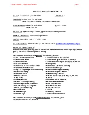
ZONING CHANGE REVIEW SHEET CASE: C14-2026-0007 (Eastside Hub) DISTRICT: 1 ADDRESS: Tract 1: 6301 FM 969 Road Tract 2: 4609 Ed Bluestein Service Road Northbound ZONING FROM: Tract 1: W/LO-CO-NP TO: CS-CO-NP Tract 2: CS-NP SITE AREA: approximately 9.8 acres (approximately 426,888 square feet) PROPERTY OWNER: Ensnail Development Inc. AGENT: Bernstein & Hall, PLLC (Dick Hall) CASE MANAGER: Jonathan Tomko, AICP (512) 974-1057, jonathan.tomko@austintexas.gov STAFF RECOMMEDATION: Staff recommends granting general commercial services-conditional overlay-neighborhood plan (CS-CO-NP) combining district zoning. The conditional overlay would prohibit the following 38 uses: - Adult Oriented Businesses - Automotive Rentals - Automotive Sales - Bail Bond Services - Commercial Blood Plasma Center - Communications Services - Drop-Off Recycling Collection Facility - Electronic Testing - Equipment Sales - Funeral Services - Hotel-Motel - Laundry Services - Off-Site Accessory Parking - Outdoor Sports and Recreation - Pedicab Storage and Dispatch - Printing and Publishing - Service Station - Vehicle Storage - Club or Lodge - Alternative Financial Services - Automotive Repair Services >5,000 sqft - Automotive Washing (of any type) >5,000 sqft - Campground - Commercial Off-Street Parking - Convenience Storage - Electronic Prototype Assembly - Equipment Repair Services - Exterminating Services - General Retail Sales (General) >5,000 sqft - Kennels - Monument Retail Services - Outdoor Entertainment - Pawn Shop Services - Performance Venue - Research Services - Theater - Veterinary Services - Transportation Terminal The conditional overlay would conditionally allow the following use: - Construction Sales and Services 17 C14-2026-0007 - Eastside Hub; District 11 of 13 PLANNING COMMISSION ACTION / RECOMMENDATION: May 12, 2026: Case is scheduled to be heard by Planning Commission. CITY COUNCIL ACTION: TBD ORDINANCE NUMBER: TBD ISSUES: N/A CASE MANAGER COMMENTS: The subject tract is currently undeveloped land on the southern side of FM 969 Road approximately 800 feet east of the intersection of Ed Bluestein Boulevard and FM 969 Road. To the north, across FM 969 Road is undeveloped land zoned CS-MU-V-DB90-NP. To the west, is a large 4-story apartment complex and a QuikTrip service station. To the south, is a major industrial manufacturing facility. To the east, is a Chevron service station with car wash, liquor store, and retail sales, and approximately 15 single-family homes. BASIS OF RECOMMENDATION: Zoning should promote clearly-identified community goals, such as creating employment opportunities or providing for affordable housing. Granting the proposed zoning would provide opportunities for a reasonable number of small-scale commercial uses within the developable portion of the site. This is in line with community plans for the Eastern Crescent to provide more employment and small business opportunities in an area that is currently identified as underserved. Zoning should allow for reasonable use of the property. The proposed zoning, with a conditional overlay prohibiting 38 uses, is reasonable for a nearly 10- acre site along an Imagine Austin Activity Corridor adjacent to other CS base district zones. Zoning should promote the policy of locating retail and more intensive zoning near the intersections of arterial roadways or at the intersections of arterials and major collectors. The subject tract is within 1,000 feet of a major intersection, Ed Bluestein Boulevard (an ASMP level 5 roadway) and FM 969 Road (an ASMP level 4 roadway). This is a very intense intersection that presents an opportunity for more intense, conditioned zoning, as recommended. EXISTING ZONING AND LAND USES: Site North (across FM 969 Rd.) South East ZONING W/LO-CO-NP and CS-NP CS-MU-V- DB90-NP LI-NP LR-NP, CS-1- CO-NP, SF-2-NP LAND USES Undeveloped land Undeveloped land Major industrial manufacturing facility (Tracor) several 2- story buildings and substantial surface parking A Chevron service station with car wash, liquor store, and retail sales, and approximately 15 single-family homes 17 C14-2026-0007 - Eastside Hub; District 12 of 13 West CS-NP A large 4-story apartment complex with approximately 288 multifamily units (Citizen House MLK) and a QuikTrip service station. NEIGHBORHOOD PLANNING AREA: East MLK (MLK-183) Combined Neighborhood Planning Area WATERSHED: Walnut Creek Watershed SCHOOLS: A.I.S.D. Norman-Sims Elementary School Martin Middle School LBJ High School COMMUNITY REGISTRY LIST: Austin Independent School District, Austin Neighborhoods Council, Del Valle Community Coalition, Dog’s Head Neighborhood Association, East MLK Combined Neighborhood Plan Contact Team, Friends of Austin Neighborhoods, Friends of Northeast Austin, Homeless Neighborhood Association, Overton Family Committee, Preservation Austin AREA CASE HISTORIES: NUMBER C14-2025-0035 (Crosstown Tunnel Centralized Odor Control Facility) REQUEST The applicant is requesting to rezone approximately 2.92 acres from LI-NP to P-NP. C14-2023-0087 (FM 969) The applicant is proposing to rezone approximately 9.98 acres from CS-1MU, LR-GO-MU, MF-2- NP to CS-VMU. COMMISSION 05.27.2025: To grant P-NP as staff recommended on the consent agenda, motion by Commissioner Woods, second by Commissioner Skidmore (10-0) Commissioners Maxwell, Anderson, and Hempel were absent. 12.12.2023: To grant staff’s recommendation of CS-MU-V-NP on the consent agenda. Motion by Commissioner Maxwell, second by Commissioner Azhar, 11-0 vote. CITY COUNCIL 07.24.2025: To grant P-NP on Council Member Vela’s motion, Council Harper-Madison’s second on an 11-0 vote. 02.01.2024: To grant CS-MU-V-NP on 2nd and 3rd readings on Council Member Harper-Madison’s motion, and Council Member Velásquez’s second, 11-0 vote. 17 C14-2026-0007 - Eastside Hub; District 13 of 13 C14-2020-0017 (MLK & 183 Residential) The Applicant is proposing to rezone approximately 9.546 acres from CS-NP and LI-CO-NP to CS-MU-NP 07.30.2020: To grant CS-MU-NP on Council Member Kitchen’s motion, Council Member Pool’s second, on an 11-0 vote. 06.23.2020: To grant CS-MU-NP as recommended by staff (10-0) Motion by Commissioner Kenny, seconded by Commissioner Azhar, Commissioner Llanes-Pulido abstained. RELATED CASES: None ADDITIONAL STAFF COMMENTS: Comprehensive Planning Project Name and Proposed Use: 6301 FM 969 ROAD. C14-2026-0007. Project: Eastside Hub. 9.8 acres from W/LO-CO-NP, CS-NP to CS-CO-NP Existing: vacant/undeveloped. Proposed: vacant, warehousing, and strip retail plaza. Yes Y Imagine Austin Decision Guidelines Complete Community Measures * Imagine Austin Growth Concept Map: Located within or adjacent to an Imagine Austin Activity Center, Imagine Austin Activity Corridor, or Imagine Austin Job Center as identified the Growth Concept Map. Names of Activity Centers/Activity Corridors/Job Centers *: • Adjacent to MLK Activity Corridor Mobility and Public Transit *: Located within 0.25 miles of public transit stop and/or light rail station. Y Mobility and Bike/Ped Access *: Adjoins a public sidewalk, shared path, and/or bike lane. • Sidewalk present along Ed Bluestein BLVD Connectivity, Good and Services, Employment *: Provides or is located within 0.50 miles to goods and services, and/or employment center. Connectivity and Food Access *: Provides or is located within 0.50 miles of a grocery store/farmers market. Connectivity and Education *: Located within 0.50 miles from a public school or university. Connectivity and Healthy Living *: Provides or is located within 0.50 miles from a recreation area, park or walking trail. Connectivity and Health *: Provides or is located within 0.50 miles of health facility (ex: hospital, urgent care, doctor’s office, drugstore clinic, and/or specialized outpatient care.) Housing Choice *: Expands the number of units and housing choice that suits a variety of household sizes, incomes, and lifestyle needs of a diverse population (ex: 17 C14-2026-0007 - Eastside Hub; District 14 of 13 apartments, triplex, granny flat, live/work units, cottage homes, and townhomes) in support of Imagine Austin and the Strategic Housing Blueprint. Housing Affordability *: Provides a minimum of 10% of units for workforce housing (80% MFI or less) and/or fee in lieu for affordable housing. Mixed use *: Provides a mix of residential and non-industrial uses. Culture and Creative Economy *: Provides or is located within 0.50 miles of a cultural resource (ex: library, theater, museum, cultural center). Culture and Historic Preservation: Preserves or enhances a historically and/or culturally significant site. Creative Economy: Expands Austin’s creative economy (ex: live music venue, art studio, film, digital, theater.) Workforce Development, the Economy and Education: Expands the economic base by creating permanent jobs, especially in industries that are currently not represented in a particular area or that promotes a new technology, and/or promotes educational opportunities and workforce development training. Industrial Land: Preserves or enhances industrial land. Not located over Edwards Aquifer Contributing Zone or Edwards Aquifer Recharge Zone Number of “Yes’s” Y Y 4 Environmental 1. The site is not located over the Edwards Aquifer Recharge Zone. The site is in the Walnut Creek Watershed of the Colorado River Basin, which is classified as a Suburban Watershed by Chapter 25-8 of the City's Land Development Code. The site is in the Desired Development Zone. 2. Under current watershed regulations, development or redevelopment on this site will be subject to the following impervious cover limits: Development Classification % of Gross Site Area % of Gross Site Area Single-Family (minimum lot size 5750 sq. ft.) Other Single-Family or Duplex Multifamily Commercial 50% 55% 60% 80% with Transfers 60% 60% 70% 90% 3. According to floodplain maps there is no floodplain within or adjacent to the project location. 4. Standard landscaping and tree protection will be required in accordance with LDC 25-2 and 25-8 for all development and/or redevelopment. 17 C14-2026-0007 - Eastside Hub; District 15 of 13 5. At this time, site specific information is unavailable regarding vegetation, areas of steep slope, or other environmental features such as bluffs, springs, canyon rimrock, caves, sinkholes, and wetlands. 6. Under current watershed regulations, development or redevelopment requires water quality control with increased capture volume and control of the 2 year storm on site. 7. At this time, no information has been provided as to whether this property has any preexisting approvals that preempt current water quality or Code requirements. Fire No comments on rezoning. PARD – Planning & Design Review PR1: Parkland dedication fees may apply to any future site plan or subdivision applications with applicable uses resulting from this rezoning. Site Plan Zoning Cases applications are intended to assist in identifying potential 1. FYI: All comments regarding the effects of the proposed rezoning on subsequent Site Plan Review development constraints but do not include all regulations which may affect a specific proposal. Changes to property boundaries and requests for development cannot include all regulatory limitations which may apply to a specific subject to modification or reconsideration if affected by a change in property boundaries or if development is proposed on only intended the a portion of to assist in identifying potential address the actual restrictions which will apply to a specific development proposal. Austin Development Services offers a variety of pre-application review options to assist in evaluating specific development proposals prior to Site Plan Application. rezoning. These comments are not development constraints, land proposed but do for 2. Site plans will be required for any new development except for residential only projects with up to 4 units. 3. Any new development is subject to Subchapter E. Design Standards and Mixed Use. Additional comments will be made when the site plan is submitted. Compatibility Standards 4. The site is subject to compatibility standards due to the adjacency of SF-2-NP parcels to the property). triggering the east (i.e., Reference 25-2-1051, 25-2-1053 5. Any structure that is located: a. At least 50 feet but less than 75 feet from any part of a triggering property may not exceed 60 feet b. Less than 50 feet from any part of a triggering property may not exceed 40 feet Reference 25-2-1061 6. A 25-foot compatibility buffer is required along the property line shared with the triggering compatibility buffer. are permitted in structures the property. No vertical Reference 25-2-1062(B), 25-8-700 17 C14-2026-0007 - Eastside Hub; District 16 of 13 7. An on-site amenity, including a swimming pool, tennis court, ball court, or playground, may property. constructed triggering from less feet the 25 be or not Reference 25-2-1062 8. There is a site plan currently under review for this property (SP-2025-0382C) which provides for a five-building development of retail, custom manufacturing, and limited warehouse uses, along with associated parking and drainage facilities. Airport Overlay 9. The site is located within Austin-Bergstrom Overlay – Controlled Compatible Land Use Area. No uses will be allowed that create electrical interference with navigational signals or radio communications between airport and aircraft, make it difficult for pilots to distinguish between the airport lights and others, result in glare in the eyes of pilots using the airport, impair visibility in the vicinity of the airport, create bird strike hazards or otherwise in any way endanger or interfere with the landing, taking off, or maneuvering of aircraft intending to use the Austin-Bergstrom Airport. Height limitations and incompatible uses with each Airport Overlay zone are established in the Airport Overlay Ordinance. Transportation and Public Works (TPW) Department – Engineering Review TPW 1. Transportation assessment/traffic impact analysis and transportation demand management plan shall be required at the time of site plan if triggered per LDC 25-6 and TCM 10.2.1. Assessment of required transportation mitigation, including the potential dedication of right of way and easements and participation in roadway and other multi-modal improvements, will occur at the time of site plan application. EXISTING STREET CHARACTERISTICS: Name ASMP Classification ASMP Required ROW Existing ROW Existing Pavement Sidewalks Bicycle Route Capital Metro (within ¼ mile) FM 969 RD Level 4 (TxDOT) 154 106 67 No Yes Yes TIA: A traffic impact analysis is NOT required. Traffic generated by the proposal does not exceed thresholds established in the City of Austin Land Development Code (LDC). Mitigation per LDC 25-6-101 may still apply. Austin Water Utility No comments on rezoning. INDEX OF EXHIBITS AND ATTACHMENTS TO FOLLOW: A. Zoning Map B. Aerial Map C. Applicant’s Summary Letter D. Correspondence from Interested Parties 17 C14-2026-0007 - Eastside Hub; District 17 of 13 17 C14-2026-0007 - Eastside Hub; District 18 of 13 17 C14-2026-0007 - Eastside Hub; District 19 of 13 Dick Hall dick@bernsteinandhall.com (832) 338-2548 January 21, 2026 Lauren Middleton-Pratt Director, City of Austin Planning Department 6310 Wilhelmina Delco Drive Austin, Texas 78752 Re: Rezoning application for 6301 FM 969 Rd and 4609 Ed Bluestein Blvd. Svrd NB, Austin, TX 78725 (the “Application”) Dear Mrs. Middleton-Pratt: This letter, along with the Application is submitted to rezone 9.803 acres of land located at 6301 FM 969 Rd and 4609 Ed Bluestein Blvd. Svrd NB (the “Property”). The Property is located near the intersection of FM 969 and Ed Bluestein Blvd (Highway 183) and is located within the MLK-183 Neighborhood Plan. One portion of the Property, 4609 Ed Bluestein Blvd. Svrd NB, is zoned General Commercial Services – Neighborhood Plan Combining District (“CS-NP”). The other portion, 6301 FM 969 Rd, is zoned Warehouse Limited Office – Conditional Overlay Combining District – Neighborhood Plan Combining District (“W/LO-CO-NP”). The entire Property is currently undeveloped. This Application seeks to rezone the Property from CS-NP and W/LO-CO-NP to General Commercial Services – Conditional Overlay Combining District – Neighborhood Plan Combining District (“CS-CO-NP”) to allow for a mixed-use development which will consist of retail and limited warehouse uses. The owner of the Property would like to unite the zoning across the two parcels to develop the two contiguous properties as a single project with the same development entitlements. The development proposed for the site, Eastside Hub, is a mission-driven retail and limited warehouse flex development designed to support and retain local small businesses and jobs in East Austin. The project is being structured to attract New Markets Tax Credit financing, bringing catalytic outside investment into the community and advancing the City’s economic development goals. The applicant would also like to note that it is in support of use restrictions on the site prohibiting certain uses that may not be proper for the area, such as Adult-Oriented Business, 17 C14-2026-0007 - Eastside Hub; District 110 of 13 Automotive Rentals, Automotive Sales, Automotive Washes, Bail Bond Services, Pawn Shop Services, and Service Station. Thank you in advance for your time and consideration of this zoning request. If you have any questions or need additional information, please do not hesitate to contact me. Sincerely, Bernstein & Hall, PLLC Dick Hall Cc: Joi Harden 17 C14-2026-0007 - Eastside Hub; District 111 of 13 17 C14-2026-0007 - Eastside Hub; District 112 of 13 For any additional questions or concerns, contact CSIRT at " ". "Report Message" button in Outlook. 17 C14-2026-0007 - Eastside Hub; District 113 of 13