13 C14-72-299(RCT) - 1317 and 1405 East Riverside Drive; District 9 - Staff Report — original pdf
Backup
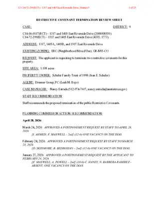
RESTRICTIVE COVENANT TERMINATION REVIEW SHEET CASE: DISTRICT: 9 C14-06-0117(RCT) – 1317 and 1405 East Riverside Drive (2008008550) C14-72-299(RCT) – 1317 and 1405 East Riverside Drive (4355; 1773) ADDRESS: 1317, 1405A, 1405B, and 1507 East Riverside Drive EXISTING ZONING: ERC (Neighborhood Mixed Use); GR-MU-CO REQUEST: The applicant is requesting to terminate two restrictive covenants for this property. SITE AREA: 1.108 acres PROPERTY OWNER: Schuler Family Trust of 1998 (Jean E. Schuler) AGENT: Drenner Group, PC (Leah M. Bojo) CASE MANAGER: Nancy Estrada (512-974-7617, nancy.estrada@austintexas.gov) STAFF RECOMMENDATION: Staff recommends the proposed termination of the public Restrictive Covenants. PLANNING COMMISSION ACTION / RECOMMENDATION: April 28, 2026: March 24, 2026: APPROVED A POSTPONEMENT REQUEST BY STAFF TO APRIL 28, 2026 [I. AHMED; F. MAXWELL – 2nd] (12-0) ONE VACANCY ON THE DIAS February 24, 2026: APPROVED A POSTPONEMENT REQUEST BY STAFF TO MARCH 24, 2026 [D. SKIDMORE; B. BEDROSIAN – 2nd] (12-0) ONE VACANCY ON THE DIAS January 27, 2026: APPROVED A POSTPONEMENT REQUEST BY THE APPLICANT TO FEBRUARY 24, 2026 [F. MAXWELL; A. POWELL – 2nd] (10-0) C. HANEY, N. BARRERA-RAMIREZ – ABSENT; ONE VACANCY ON THE DIAS 13 C14-72-299(RCT) - 1317 and 1405 East Riverside Drive; District 91 of 25 C14-96-0127(RCT) Page 2 December 9, 2026: APPROVED A POSTPONEMENT REQUEST BY THE APPLICANT TO JANUARY 27, 2026 [F. MAXWELL; J. HILLER – 2nd] (10-0) A. WOODS, P. HOWARD – ABSENT; ONE VACANCY ON THE DIAS CITY COUNCIL ACTION: RESTRICTIVE COVENANT TERMINATION RECORDING NUMBER: ISSUES: None at this time. CASE MANAGER COMMENTS: The proposed Restrictive Covenant Termination area consists of approximately 1.108 acres and is located at the southeast corner of Interstate Highway (IH) 35 and East Riverside Drive. The portion of the property with frontage along IH 35 is currently undeveloped, while the portion along East Riverside Drive currently has two small one-story office buildings. Please refer to Exhibits A and B (Zoning Maps) and Exhibits C and D (Aerial Views). The applicant is requesting to terminate two public restrictive covenants that were recorded in 1972 and 2008. The Restrictive Covenants include various conditions related to sustainability requirements, limits on building heights and vehicle trips per day, fencing requirements and restrictions on access points. These conditions are no longer aligned with current City code or development standards. Please refer to Attachments A and B (Restrictive Covenants). Austin Transportation and Public Works has no objections to the applicant’s request to terminate the restrictive covenant condition related to access. Site access is governed by the Transportation Criteria Manual (TCM) and any applicable transportation analysis associated with future development. Staff recommends the termination of both public Restrictive Covenants. Staff supports the deletion of these conditions because these items are regulated by either the current zoning district site development standards/requirements stipulated by the Land Development Code or the Regulating Plan for the East Riverside Corridor zoning district. Additionally, several of the provisions would not typically be included in a restrictive covenant under current standards. EXISTING ZONING AND LAND USES: ZONING LAND USES Site GR-MU-CO; Undeveloped; 2 Office buildings 13 C14-72-299(RCT) - 1317 and 1405 East Riverside Drive; District 92 of 25 C14-96-0127(RCT) Page 3 ERC (Neighborhood Mixed Use) North N/A South East SF-3-NP SF-3-NP; ERC (Neighborhood Mixed Use) N/A West East Riverside Drive Single family residential Single family residential Interstate Highway 35 Service Road Northbound NEIGHBORHOOD PLANNING AREA: East Riverside/Oltorf Combined WATERSHEDS: Lady Bird Lake and Harper’s Branch – Urban CAPITOL VIEW CORRIDOR: No SCENIC ROADWAY: Yes- East Riverside Drive SCHOOLS: Austin Independent School District Travis Heights Elementary School Lively Middle School Travis High School COMMUNITY REGISTRY LIST: Austin Independent School District, Austin Neighborhoods Council, Crossing Gardenhome Owners Assn. (The), Del Valle Community Coalition, East Austin Conservancy, East Riverside/Oltorf Neighborhood Plan Contact Team, Friends of Austin Neighborhoods, Homeless Neighborhood Association, Monaco South East Austin, Overton Family Committee , Pleasant Valley, Preservation Austin, South Central Coalition, South River City Citizens Assn., Southeast Austin Neighborhood Alliance, Zoning Committee of South River City Citizens COMMISSION CITY COUNCIL Withdrawn (12/3/2025) N/A AREA CASE HISTORIES: NUMBER C14-2024-0146 – 1317 E. Riverside Drive REQUEST GR-MU-CO to GR-MU-CO-V- DB90 RELATED CASES: C14-06-0117 – Associated zoning case C14-04-0030 – Associated zoning case 13 C14-72-299(RCT) - 1317 and 1405 East Riverside Drive; District 93 of 25 C14-05-0151(RCT) Page 4 ADDITIONAL STAFF COMMENTS: Austin Transportation Department – Engineering Review: No review required. Site Plan Review: Site plan comments will be issued at the time of site plan submittal. The site plan review team has no concerns with the termination of the restrictive covenant. PARD – Planning & Design Review: Parkland dedication will be required at the time of subdivision or site plan application for new residential units, per City Code § 25-1-601, as amended. Whether the requirement shall be met with fees in-lieu or dedicated land will be determined using the criteria in City Code Title 25, Article 14, as amended. Should fees in-lieu be required, those fees shall be used toward park investments in the form of land acquisition and/or park amenities within the surrounding area, per the Parkland Dedication Operating Procedures § 14.3.11 and City Code § 25-1-609, as amended. Note that residential units that are certified affordable and income-restricted are exempt from the parkland dedication requirements per City Code § 25-1-601(D)(4). Also note that part of this site is within the East Riverside Corridor regulating plan and will be reviewed under those regulations. If the applicant wishes to discuss parkland dedication requirements in advance of site plan or subdivision applications, please contact this reviewer: ann.desanctis@austintexas.gov. At the applicant’s request, PARD can provide an early determination of whether fees in-lieu of land will be allowed. Comprehensive Planning Review: The initiation, termination or amending of a Restrictive Covenant is not under the purview of the policies of the Imagine Austin Comprehensive Plan and therefore an Imagine Austin compliance report has not been provided for this case. Austin Water: No review required. 13 C14-72-299(RCT) - 1317 and 1405 East Riverside Drive; District 94 of 25 C14-05-0151(RCT) Page 5 INDEX OF EXHIBITS AND ATTACHMENTS TO FOLLOW: Exhibit A: Zoning Map – C14-06-0117(RCT) Exhibit B: Zoning Map – C14-72-299(RCT) Exhibit C: Aerial Map – C14-06-0117(RCT) Exhibit D: Aerial Map – C14-72-299(RCT) Applicant’s Summary Letters Attachment A: Restrictive Covenant – Document No. 2008008550 Attachment B: Restrictive Covenant – Book 4355, Page 1773-1775 13 C14-72-299(RCT) - 1317 and 1405 East Riverside Drive; District 95 of 25 N I H 3 5 N B N I H 3 5 S B N I H 3 5 S V R D N B S I H 3 5 N B T O F L O R E S R A M P 05-0139 SF-3-NP ( ( C14H-97-0009 P-NP E RIVERSIDE DR 05-0139 ( ( 58-16 57-110 P-H-NP 88-31 C14H-97-0008 05-0139 P-NP SF-3-NP SP-98 ( 70-100 ( ( NO-ETOD-DBETOD-NP HARWOOD PL ( ( ( ( ( ( ( ( ( ( 78-108 ( ( ( SF-3-NP ( ( ( ( ( ( ( ( SF-3-NP ( ( ( ( SF-3-NP ( ( ( ( ( 05-0139 ( SF-3-NP M TE R ( ( ( ( ( SF-3-NP ( ( ( ( A ( H N ( O SF-3-H-NP B ( ( C14H-2015-0147 ( ( SF-3-NP ( ( SF-3-NP C14-05-0139 SP95-0028C ( ( ( ( 05-0139 P72-10 GO-CO-ETOD-DBETOD-NP 69-144 ( ( ( REAGAN TER ( ( ( PARKINSON DR ( ( SF-3-NP ( OFFICE ( ( ( 05-0139 ( ( N A L E S L E H C ( ( ( ( ( ( ( ( SF-3-NP 05-0139 ( ( R Y JO D ( ( ( ( ( ( SF-3-NP ( ( ( ( ( T T E B GO-CO-ETOD-DBETOD-NP ( ( ( ( ( GO-ETOD-DBETOD-NP ( C14-2007-0224 S I H 3 5 S B S I H 3 5 N B 65-33 05-0139 P-NP 00-2102 00-2102 C14-00-2102 P-NP NCDSA 001214-20 88-29 ( ( SF-3-NP MARTIN PARK P-NP 00-2102 CHICON ST P-NP C14-01-0166 NP-01-0010 59-139 VAC. BLDG. 06-0053 ERC C14-06-0053 COLORADO RIVER LADY BIRD LAKE 06-0053 62-31 69-215 70-98 73-160 ERC C14-01-0002 01-0002 C14-2021-0029 81-52 C14-01-0001 APTS. ! ! ! ! 69-257 ! ! ! ! ! ! ! ! ! ! C14-06-0117 ! ! ! ! ! ! NPA-2020-0021.02 ( ( C14-2020-0081 ! ! ! NO-MU-NP ! ! ! ! ! ! ! ! ! ! ! ! ! ! ! ! ! ! ! ! !! ! ! ! 77-39 ! ! ! ! ! ! ! ! ERC ! C14-04-0030 ! ! ! ! ! ! ! ! 04-0030 ! ! ! ! ! ! ! !! ! !! ! ! ! ! ! ! ! !! !! ! ( ! ! ! T S ( E V O L N A M ( GR-MU-CO ! ! ! ! ! ! ( ! ! ! ! ! ! ! ! ! ! ! ! ! 9 9 2 - 2 7 ! ! ! ! ! ! ( 73-91 ( SF-3-NP (( INGLEWOOD ST ( ( SF-3-NP ( LR-NP P M A R N A G A E R O T B S 5 3 H I S P M A E R SID R E O E RIV ( ( SF-3-NP ( LUPINE LN ( SF-3-NP ( LO-CO-NP ( LR-MU-CO-NP MF-2 B T 5 N MF-4-NP S IH 3 MF-4 66-63 ( ( MF-4-NP ( APTS. ( ( 60-142 APTS. APTS. APTS. ERC SP-2007-0494D 05-0112 68-125 C14-05-0112(RCA) APTS. C14-05-0112(RCA2) CONV.STORE GAS E R O T C. S 74-52 G. D L C. B VA P69-8 E L E ( DRESS 64- OLD EAST RIVERSIDE DR ( ( VAC ( ( C14-05-0112 ( ( ( ( ( ( ( SF-3-NP ( R ( D D N A ( L P U ( ( ( ( ( ( 62-81 ( ( ( ( T MIT S M U S ( ( ( ( ( ( ( ( ( ( SF-3-NP ( ( ( ( ( SUNNY VALE ST ( ( ( ( SF-3-NP ( ( ( ( ( ( ( ( ( ( ( ( ( ( ( R A D ( M ( O SF-3-NP L ( 75-44 ( 63-157 ORIENTAL STORE ( R A D ( M LO ( ( = = ( 69-9 UNDEV MF-2-CO-NP C14-03-0077 APTS. APTS 2 0 1-1 7 ! N R L E K R ! PA ! ! 75-55 P79-56 ! NPA-2011-0021.02 P75-20 P79-15 ERC 73-214 C14-2012-0111 NPA-2012-0021.02 SOUTH LAKESHORE BLVD REST. 63-49 MAT PUD-NP ERC C814-2008-0087 SPC-02-0001C PARTS PUD ERC 77-20 LUBE 80-42 FAST ERC ( NPA-2007-0021.01 ( ! Restrictive Covenant Termination ! ( ! ! ! ! ! ! ! ! ! ! ! ( ! ! ! ! 93-0121 67-225 ERC 9 1 6-0 7 72-143 ERC 71-102 ! ! ! ! ! ! B D S R V 5 S S IH 3 B D N R V 5 S S IH 3 REALTOR OFFC GO-NP ( C14-04-0136 GR-MU-CO-NP ( ( 69-152 ( ( ( ( ( ( ( ( ( SF-3-NP = ( ( SF-3-NP ( ( ( ( ( ( R E D ( LAIR ( EL B ( SF-3-NP ( = ELMHURST DR ( = ( SF-3-NP ( ( ( ( GR-CO-ETOD-DBETOD-NP C14-2012-0100 CS-CO-ETOD-DBETOD-NP LO-NP ± SUBJECT TRACT ! ! ! ! ! ! PENDING CASE ZONING BOUNDARY ZONING CASE#: C14-06-0117(RCT) EXHIBIT A ! ! ! ! This product is for informational purposes and may not have been prepared for or be suitable for legal, engineering, or surveying purposes. It does not represent an on-the-ground survey and represents only the approximate relative location of property boundaries. ! ! 1 " = 400 ' This product has been produced by the Planning Department for the sole purpose of geographic reference. ! No warranty is made by the City of Austin regarding specific accuracy or completeness. ! ! ! ! ! Created: 10/25/2024 ! ! ! ! ! ! ! ! ! ! ! ! 13 C14-72-299(RCT) - 1317 and 1405 East Riverside Drive; District 96 of 25 N I H 3 5 N B N I H 3 5 S B N I H 3 5 S V R D N B S I H 3 5 N B T O F L O R E S R A M P 05-0139 SF-3-NP ( ( C14H-97-0009 P-NP E RIVERSIDE DR 05-0139 ( ( 58-16 57-110 P-H-NP 88-31 C14H-97-0008 05-0139 P-NP SF-3-NP SP-98 ( 70-100 ( ( NO-ETOD-DBETOD-NP HARWOOD PL ( ( ( ( ( ( ( ( ( ( 78-108 ( ( ( SF-3-NP ( ( ( ( ( ( ( ( SF-3-NP ( ( ( ( SF-3-NP ( ( ( ( ( 05-0139 ( SF-3-NP M TE R ( ( ( ( ( SF-3-NP ( ( ( ( A ( H N ( O SF-3-H-NP B ( ( C14H-2015-0147 ( ( SF-3-NP ( ( SF-3-NP C14-05-0139 SP95-0028C ( ( ( ( 05-0139 P72-10 GO-CO-ETOD-DBETOD-NP 69-144 ( ( ( REAGAN TER ( ( ( PARKINSON DR ( ( SF-3-NP ( OFFICE ( ( ( 05-0139 ( ( N A L E S L E H C ( ( ( ( ( ( ( ( SF-3-NP 05-0139 ( ( R Y JO D ( ( ( ( ( ( SF-3-NP ( ( ( ( ( T T E B GO-CO-ETOD-DBETOD-NP ( ( ( ( ( GO-ETOD-DBETOD-NP ( C14-2007-0224 S I H 3 5 S B S I H 3 5 N B 65-33 05-0139 P-NP 00-2102 00-2102 C14-00-2102 P-NP NCDSA 001214-20 88-29 ( ( SF-3-NP MARTIN PARK P-NP 00-2102 CHICON ST P-NP C14-01-0166 NP-01-0010 59-139 VAC. BLDG. 06-0053 ERC C14-06-0053 COLORADO RIVER LADY BIRD LAKE 06-0053 62-31 69-215 70-98 73-160 ERC C14-01-0002 01-0002 C14-2021-0029 81-52 C14-01-0001 APTS. ! ! ! ! 69-257 ! ! ! ! ! ! ! ! ! ! C14-06-0117 ! ! ! ! ! ! NPA-2020-0021.02 ( ( C14-2020-0081 ! ! ! NO-MU-NP ! ! ! ! ! ! ! ! ! ! ! ! ! ! ! ! ! ! ! ! !! ! ! ! 77-39 ! ! ! ! ! ! ! ! ERC ! C14-04-0030 ! ! ! ! ! ! ! ! 04-0030 ! ! ! ! ! ! ! !! ! !! ! ! ! ! ! ! ! !! !! ! ( ! ! ! T S ( E V O L N A M ( GR-MU-CO ! ! ! ! ! ! ( ! ! ! ! ! ! ! ! ! ! ! ! ! 9 9 2 - 2 7 ! ! ! ! ! ! ( 73-91 ( SF-3-NP (( INGLEWOOD ST ( ( SF-3-NP ( LR-NP P M A R N A G A E R O T B S 5 3 H I S P M A E R SID R E O E RIV ( ( SF-3-NP ( LUPINE LN ( SF-3-NP ( LO-CO-NP ( LR-MU-CO-NP MF-2 B T 5 N MF-4-NP S IH 3 MF-4 66-63 ( ( MF-4-NP ( APTS. ( ( 60-142 APTS. APTS. APTS. ERC SP-2007-0494D 05-0112 68-125 C14-05-0112(RCA) APTS. C14-05-0112(RCA2) CONV.STORE GAS E R O T C. S 74-52 G. D L C. B VA P69-8 E L E ( DRESS 64- OLD EAST RIVERSIDE DR ( ( VAC ( ( C14-05-0112 ( ( ( ( ( ( ( SF-3-NP ( R ( D D N A ( L P U ( ( ( ( ( ( 62-81 ( ( ( ( T MIT S M U S ( ( ( ( ( ( ( ( ( ( SF-3-NP ( ( ( ( ( SUNNY VALE ST ( ( ( ( SF-3-NP ( ( ( ( ( ( ( ( ( ( ( ( ( ( ( R A D ( M ( O SF-3-NP L ( 75-44 ( 63-157 ORIENTAL STORE ( R A D ( M LO ( ( = = ( 69-9 UNDEV MF-2-CO-NP C14-03-0077 APTS. APTS 2 0 1-1 7 ! N R L E K R ! PA ! ! 75-55 P79-56 ! NPA-2011-0021.02 P75-20 P79-15 ERC 73-214 C14-2012-0111 NPA-2012-0021.02 SOUTH LAKESHORE BLVD REST. 63-49 MAT PUD-NP ERC C814-2008-0087 SPC-02-0001C PARTS PUD ERC 77-20 LUBE 80-42 FAST ERC ( NPA-2007-0021.01 ( ! Restrictive Covenant Termination ! ( ! ! ! ! ! ! ! ! ! ! ( ! ! ! ! 93-0121 67-225 ERC 9 1 6-0 7 72-143 ERC 71-102 ! ! ! ! ! ! B D S R V 5 S S IH 3 B D N R V 5 S S IH 3 REALTOR OFFC GO-NP ( C14-04-0136 GR-MU-CO-NP ( ( 69-152 ( ( ( ( ( ( ( ( ( SF-3-NP = ( ( SF-3-NP ( ( ( ( ( ( R E D ( LAIR ( EL B ( SF-3-NP ( = ELMHURST DR ( = ( SF-3-NP ( ( ( ( GR-CO-ETOD-DBETOD-NP C14-2012-0100 CS-CO-ETOD-DBETOD-NP LO-NP ± SUBJECT TRACT ! ! ! ! ! ! PENDING CASE ZONING BOUNDARY EXHIBIT B ZONING CASE#: C14-72-299(RCT) ! ! ! ! ! This product is for informational purposes and may not have been prepared for or be suitable for legal, engineering, or surveying purposes. It does not represent an on-the-ground survey and represents only the approximate relative location of property boundaries. ! ! 1 " = 400 ' This product has been produced by the Planning Department for the sole purpose of geographic reference. ! No warranty is made by the City of Austin regarding specific accuracy or completeness. ! ! ! ! ! Created: 10/25/2024 ! ! ! ! ! ! ! ! ! ! ! ! 13 C14-72-299(RCT) - 1317 and 1405 East Riverside Drive; District 97 of 25 EXHIBIT C !!!!!!!!!!!!!!!!!!!!!!!!!!!!!!!!!!!!!!!!!!!!!!!!!!!!!!!!!!!!!!!!!!!!!!!!!!!!!!!!!!!!!!!!!!!!!!!!!!!!!!!!!!!!!!!!!!!!!!!!!!!!!!!!!!!!!!!!!!!!!!!!!!!!!!!!!!!!!!!!!!!!!!!!!!!!!!!!!!!!!!!!!!!!!!!!!!!!!!!!!!!!!!!!!!!!!!!!!!!!!!!!!!!!!!(!(!(!(!(!(!(!(!(!(!(!(!(!(!(!(!(!(!(!(!(!(!(!(!(!(!(!(!(!(!(!(!(!(!(!(!(!(!(!(!(!(!(!(!(!(!(!(!(!(!(!(!(!(!(!(!(!(!(!(!(!(!(!(!(!(!(!(!(!(!(!(!(!(!(!(!(!(!(!(!(!(!(!(!(!(!(!(!(!(!(!(!(!(!(!(!(!(!(!(!(!(!(!(!(!(!(!(!(!(!(!(!(!(!(!(!(!(!(!(!(!(!(!(!(!(!(!(!(!(!(!(!(!(!(!(!(!(!(!(!(!(!(!(!(!(!(!(!(!(!(!(!(!(!(!(!(!(!(!(!(!(!(!(!(!(!(!(!(!(!(!(!(!(!(!(!(!(!(!(!(!(!(!(!(!(!(!(!(!(!(!(!(!(!(!(!(!(!(!(!(!(!(!(!(!(!(!(!(!(!(!(!(!(!(!(!(!(!(!(!(!(!(!=!=!=!=!=C14-06-0117(RCT)C14-05-0112C14-05-0139C14-2012-0111NPA-2011-0021.02NPA-2012-0021.02C14-00-2102C14-05-0112(RCA)C14-05-0112(RCA2)NP-01-0010C14-01-0166C14H-97-0008C814-2008-0087C14-2021-0029C14-04-0030C14-06-0117C14-01-0002C14-06-0053C14-2012-0100C14-03-0077C14-01-0001C14-04-0136C14-2007-0224C14H-97-0009C14H-2015-0147NPA-2007-0021.01C14-2020-0081NPA-2020-0021.02SIH35SBSIH35NBSIH35SVRDSBSIH35SVRDNBSUMMITSTLUPINELNREAGANTERELMHURSTDRSUNNYVALESTPARKERLNNASHHERNANDEZSRRDKENWOODAVEERIVERSIDEDRBONHAMTERUPLANDDRCHELSEALNBETTYJODRLOMADROLDEASTRIVERSIDEDREDGECLIFFTERNIH35SBBELLAIREDRCHICONSTHARWOODPLNIH35NBINGLEWOODSTSOUTH LAKESHORE BLVDNIH35SVRDNBMANLOVESTMILAM PLTAYLORGAINESSTAVONDALE RDNIH35SVRDSBERIVERSIDEWBTO35NBRAMPSIH35SBTOREAGANRAMPREAGANTOIH35SBRAMPSIH35NBTOERIVERSIDERAMPPARKINSONDRLOMADRMANLOVESTERCP-NPP-NPERCSF-3-NPSF-3-NPERCP-NPSF-3-NPERCERCERCSF-3-NPERCSF-3-NPSF-3-NPSF-3-NPP-NPGO-CO-ETOD-DBETOD-NPERCSF-3-NPSF-3-NPSF-3-NPMF-4SF-3-NPSF-3-NPPUDPUD-NPERCMF-2GO-NPSF-3-NPSF-3-NPSF-3-NPP-NPSF-3-NPSF-3-NPSF-3-NPSF-3-NPSF-3-NPSF-3-NPMF-2-CO-NPSF-3-NPP-NPMF-4-NPSF-3-NPLO-NPP-H-NPSF-3-NPGO-CO-ETOD-DBETOD-NPGR-MU-COLR-NPLR-MU-CO-NPCS-CO-ETOD-DBETOD-NPGR-MU-CO-NPGR-CO-ETOD-DBETOD-NPGO-ETOD-DBETOD-NPNO-ETOD-DBETOD-NPLO-CO-NPSF-3-H-NPSF-3-NPERCNO-MU-NPMF-4-NPMF-3-NP1317 and 1405 E Riverside Drive - RC Termination 2008008550±This product has been produced by Austin Planning for the sole purpose of geographic reference. No warranty is madeby the City of Austin regarding specific accuracy or completeness.ZONING CASE#:LOCATION:SUBJECT AREA:MANAGER:C14-06-0117(RCT)1317, 1405A, 1405B,1507 E Riverside Dr1.108 AcresNancy EstradaCreated: 12/2/2025SUBJECT TRACTZONING BOUNDARY!!!!!PENDING CASECREEK BUFFER1 inch equals 400 '13 C14-72-299(RCT) - 1317 and 1405 East Riverside Drive; District 98 of 25 EXHIBIT D !!!!!!!!!!!!!!!!!!!!!!!!!!!!!!!!!!!!!!!!!!!!!!!!!!!!!!!!!!!!!!!!!!!!!!!!!!!!!!!!!!!!!!!!!!!!!!!!!!!!!!!!!!!!!!!!!!!!!!!!!!!!!!!!!!!!!!!!!!!!!!!!!!!!!!!!!!!!!!!!!!!!!!!!!!!!!!!!!!!!!!!!!!!!!!!!!!!!!!!!!!!!!!!!!!!!!!!!!!!!!!!!!!!!!!(!(!(!(!(!(!(!(!(!(!(!(!(!(!(!(!(!(!(!(!(!(!(!(!(!(!(!(!(!(!(!(!(!(!(!(!(!(!(!(!(!(!(!(!(!(!(!(!(!(!(!(!(!(!(!(!(!(!(!(!(!(!(!(!(!(!(!(!(!(!(!(!(!(!(!(!(!(!(!(!(!(!(!(!(!(!(!(!(!(!(!(!(!(!(!(!(!(!(!(!(!(!(!(!(!(!(!(!(!(!(!(!(!(!(!(!(!(!(!(!(!(!(!(!(!(!(!(!(!(!(!(!(!(!(!(!(!(!(!(!(!(!(!(!(!(!(!(!(!(!(!(!(!(!(!(!(!(!(!(!(!(!(!(!(!(!(!(!(!(!(!(!(!(!(!(!(!(!(!(!(!(!(!(!(!(!(!(!(!(!(!(!(!(!(!(!(!(!(!(!(!(!(!(!(!(!(!(!(!(!(!(!(!(!(!(!(!(!(!(!(!(!(!=!=!=!=!=C14-72-299(RCT)C14-05-0112C14-05-0139C14-2012-0111NPA-2011-0021.02NPA-2012-0021.02C14-00-2102C14-05-0112(RCA)C14-05-0112(RCA2)NP-01-0010C14-01-0166C14H-97-0008C814-2008-0087C14-2021-0029C14-04-0030C14-06-0117C14-01-0002C14-06-0053C14-2012-0100C14-03-0077C14-01-0001C14-04-0136C14-2007-0224C14H-97-0009C14H-2015-0147NPA-2007-0021.01C14-2020-0081NPA-2020-0021.02S IH 35 SBS IH35 NBS IH35 SVRD SBS IH 35 SVRD NBSUMMIT STLUPINELNREAGAN TERELMHURSTDRSUNNYVALESTPARKERLNNASH HERNANDEZ SR RDKENWOOD AVEE RIVERSIDE DRBONHAM TERUPLAND DRCHELSEA LNBETTY JO DRLOMA DROLD EAST RIVERSIDE DREDGECLIFF TERN IH 35 SBBELLAIRE DRCHICONSTHARWOOD PLN IH35 NBINGLEWOOD STSOUTH LAKESHORE BLVDN IH 35 SVRD NBMANLOVE STMILAM PLTAYLORGAINESSTAVONDALE RDN IH35 SVRDSBE RIVERSIDE WB TO 35 NB RAMPS IH35SBTOREAGANRAMPREAGAN TOIH 35 SB RAMPS IH 35 NB TO ERIVERSIDE RAMPPARKINSON DRLOMA DRMANLOVE STERCP-NPP-NPERCSF-3-NPSF-3-NPERCP-NPSF-3-NPERCERCERCSF-3-NPERCSF-3-NPSF-3-NPSF-3-NPP-NPGO-CO-ETOD-DBETOD-NPERCSF-3-NPSF-3-NPSF-3-NPMF-4SF-3-NPSF-3-NPPUDPUD-NPERCMF-2GO-NPSF-3-NPSF-3-NPSF-3-NPP-NPSF-3-NPSF-3-NPSF-3-NPSF-3-NPSF-3-NPSF-3-NPMF-2-CO-NPSF-3-NPP-NPMF-4-NPSF-3-NPLO-NPP-H-NPSF-3-NPGO-CO-ETOD-DBETOD-NPGR-MU-COLR-NPLR-MU-CO-NPCS-CO-ETOD-DBETOD-NPGR-MU-CO-NPGR-CO-ETOD-DBETOD-NPGO-ETOD-DBETOD-NPNO-ETOD-DBETOD-NPLO-CO-NPSF-3-H-NPSF-3-NPERCNO-MU-NPMF-4-NPMF-3-NP1317 and 1405 E Riverside Drive - RC Termination 4355; 1773±This product has been produced by Austin Planning for the sole purpose of geographic reference. No warranty is madeby the City of Austin regarding specific accuracy or completeness.ZONING CASE#:LOCATION:SUBJECT AREA:MANAGER:C14-72-299(RCT)1317, 1405 A & B, 1507E Riverside Dr1.108 AcresNancy EstradaCreated: 12/2/2025SUBJECT TRACTZONING BOUNDARY!!!!!PENDING CASECREEK BUFFER1 inch equals 400 '13 C14-72-299(RCT) - 1317 and 1405 East Riverside Drive; District 99 of 25 September 27, 2024 Via Electronic Delivery Ms. Lauren Middleton-Pratt Planning Department City of Austin 1000 E 11th Street, Suite 200 Austin, TX 78702 Re: 1317 E Riverside Drive and 1405 E Riverside Drive – Restrictive Covenant Termination application for that certain Restrictive Covenant recorded under Document 2008008550 of the Official Public Records of Travis County, Texas (the “Restrictive Covenant”) located on that certain property known as Lot 1 of Lela Parkinson Subdivision, Block A, Lots 1-2 of The Schuler Subdivision, and 1.108 acres, more or less, out of the Santiago Del Valle Grant, Travis County, Texas (the “Property”). Dear Ms. Middleton-Pratt: As representatives of the owner of the Property, we respectfully submit the enclosed Restrictive Covenant Termination application package. The TCAD IDs for the Property are 0302060201, 0302060243, 0302060244, 0302060205, 0302060214 and 0302060216 with the following legal descriptions: Tract 1 on Warranty Deed 2002055238: Being Lot 1, of Lela Parkinson Subdivision, a subdivision in Travis County, Texas, according to the map or plat thereof recorded in Book 17, Page 34, Plat Records of Travis County, Texas. Tract 2 on Warranty Deed 2002055238 (Block A, Lot 1, Schuler Subdivision): Being 0.587 of one acre of land, more or less, out of the Santiago Del Valle Grant, Travis County, Texas. All of that certain tract or parcel of land out of the Santiago Del Valle Grant in the City of Austin, Travis County, Texas, being that same tract of land conveyed to W. Ralph Canada, Jr. by instrument recorded in Document 2001022850 of the Official Public Records of Travis County Texas. Tract 3 on Warranty Deed 2002055238 (Block A, Lot 2, Schuler Subdivision): 0.726 acres, more or less, out of the Santiago Del Valle Grant, Travis County, Texas. All of that certain tract or parcel of land out of the Santiago Del Valle Grant in the City of Austin, Travis County, Texas, being that same tract of land called 0.725 acre of land conveyed to W. Ralph Canada, Jr. by instrument recorded in Volume 12000, Page 2134 of the Real Property Records of Travis County, Texas. Tract 4 on Warranty Deed 2002055238: 1.108 acres, more or less, out of the Santiago Del Valle Grant, Travis County, Texas, and a portion of Lots 11, 12, 13, 15 & 16, Block 12 of Bellvue Park, a subdivision in Travis County, Texas, according to the map or plat thereof recorded in Book 1, Page 45, Plat Records of Travis County, Texas. All of that certain tract or parcel of land out of the Santiago Del Valle Grant in the City of Austin, Travis County, Texas, being that same tract of land called 1.109 acres of land conveyed to W. Ralph Canada, Jr. by instrument recorded in Volume 11928, Page 187 of the Real Property Records of Travis County, Texas. 13 C14-72-299(RCT) - 1317 and 1405 East Riverside Drive; District 910 of 25 The property was conveyed to the Schuler Family Trust of 1998 in Warranty Deed, Document No. 2002055238, of the Official Public Records of Travis County, Texas. A Restrictive Covenant was recorded in Document No. 2008008550 of the Official Public Records of Travis County, Texas. The Restrictive Covenant is associated with the Zoning Cases C14-06-0117 and C14-04-0030. On behalf of the owner, we are proposing to rezone the properties for development (associated case number pending) which conflicts with the provisions of this Restrictive Covenant. 1. Per Document No. 2008008550 (related to Zoning Cases C14-06-0117 and C14-04-0030) of the Official Public Records of Travis County, Texas: Restrictive Covenant Exhibit B a. Commercial spaces shall have the flexibility to be finished out as office space or retail space. b. Dumpsters and service areas shall be contained within the buildings. c. Mechanical equipment shall be screened. d. A 25-foot wide heavily vegetated buffer (Compatibility Setback per Exhibit B) shall be provided and maintained along the property lines that run along the adjacent residential areas of the Property. Improvements permitted within the buffer zone are limited to landscaping, screening, underground utility and drainage improvements or those improvements that may be otherwise required by the City of Austin or specifically authorized in this covenant. Within the buffer Class I trees shall be planted 20 feet on center, with modifications permitted to accommodate improvements as defined in this paragraph. A tree may be omitted where existing trees remain. e. Sidewalks and streetscapes shall be built to the standards set forth in Subchapter E: f. Design Standards and Mixed Use of the City Code. Twenty-five percent of the total number of roof surfaces in the project shall be covered with live vegetation. This vegetation may be contained in pots, planters, or other containers, or grown-in other media. Documentation must be submitted demonstrating that the roof can support the additional load of plants, soil and retained water, and that an adequate soil depth will be provided for plants to thrive. g. All structures shall use the same building materials, including masonry, on all sides of the structures. 13 C14-72-299(RCT) - 1317 and 1405 East Riverside Drive; District 911 of 25 i. h. Prior to certificate of occupancy, existing retaining walls shall be removed along East Riverside Drive and the site excavated to street level, except where shown on Exhibit “B”. A protected tree removed during excavation of the site must be replaced at 100 percent. All points of access shall have interconnectivity to allow access for all development to both the IH-35 frontage road and Riverside Drive. No access is allowed to Summit Street or Manlove Street. Access from the Property is limited to two driveway cuts to Riverside Drive and one driveway cut to the east frontage road of IH-35. j. k. A building or structure constructed on Tract C shall not exceed a height of two stories l. and must include underground parking. A parking structure constructed on any part of the Property must be contained in a structure up to two levels above grade and may be no higher than the existing grade of the adjacent property located along the south property line of the subject Property. m. The maximum number of units on Tract A and Tract B combined is 65 residential units. If vertical mixed use building standards are applied to development of the Property, the residential units may be increased to 100 units. Vertical mixed use building means the Property is subject to Chapter 25-2, Subchapter E, Article 4.3 (Vertical Mixed Use Buildings). n. Non-residential uses of the Property (Tracts A, B and C) may not exceed 75,000 square feet of gross floor area. If the maximum 75,000 square feet is used, then the building square footage for Tracts A and B combined may not exceed 50,000 square feet. o. A site plan or building permit for the Property may not be approved, released or issued if the completed development or uses of the Property, considered cumulatively with all existing or previously authorized development and uses, generate traffic that exceeds 2,000 trips per day unless a traffic impact analysis (TIA) is submitted and approved by the Director of Watershed Protection and Development Review Department. p. All residential and commercial development shall comply with the Austin Energy Green Building Program for a minimum two-star rating. Certification shall be met as specified by the version of the rating system current at the time of design. Please let me know if you or your team members require additional information or have any questions. Thank you for your time and attention to this project. Sincerely, Leah M. Bojo 13 C14-72-299(RCT) - 1317 and 1405 East Riverside Drive; District 912 of 25 September 27, 2024 Via Electronic Delivery Ms. Lauren Middleton-Pratt Planning Department City of Austin 1000 E 11th Street, Suite 200 Austin, TX 78702 Re: 1317 E Riverside Drive and 1405 E Riverside Drive – Restrictive Covenant Termination application for that certain Restrictive Covenant recorded under Book 4355, Page 1773 of the Official Public Records of Travis County, Texas (the “Restrictive Covenant”) located on that certain property known as Lot 1 of Lela Parkinson Subdivision, Block A, Lots 1-2 of The Schuler Subdivision, and 1.108 acres, more or less, out of the Santiago Del Valle Grant, Travis County, Texas (the “Property”). Dear Ms. Middleton-Pratt: As representatives of the owner of the Property, we respectfully submit the enclosed Restrictive Covenant Termination application package. The TCAD IDs for the Property are 0302060201, 0302060243, 0302060244, 0302060205, 0302060214 and 0302060216 with the following legal descriptions: Tract 1 on Warranty Deed 2002055238: Being Lot 1, of Lela Parkinson Subdivision, a subdivision in Travis County, Texas, according to the map or plat thereof recorded in Book 17, Page 34, Plat Records of Travis County, Texas. Tract 2 on Warranty Deed 2002055238 (Block A, Lot 1, Schuler Subdivision): Being 0.587 of one acre of land, more or less, out of the Santiago Del Valle Grant, Travis County, Texas. All of that certain tract or parcel of land out of the Santiago Del Valle Grant in the City of Austin, Travis County, Texas, being that same tract of land conveyed to W. Ralph Canada, Jr. by instrument recorded in Document 2001022850 of the Official Public Records of Travis County Texas. Tract 3 on Warranty Deed 2002055238 (Block A, Lot 2, Schuler Subdivision): 0.726 acres, more or less, out of the Santiago Del Valle Grant, Travis County, Texas. All of that certain tract or parcel of land out of the Santiago Del Valle Grant in the City of Austin, Travis County, Texas, being that same tract of land called 0.725 acre of land conveyed to W. Ralph Canada, Jr. by instrument recorded in Volume 12000, Page 2134 of the Real Property Records of Travis County, Texas. Tract 4 on Warranty Deed 2002055238: 1.108 acres, more or less, out of the Santiago Del Valle Grant, Travis County, Texas, and a portion of Lots 11, 12, 13, 15 & 16, Block 12 of Bellvue Park, a subdivision in Travis County, Texas, according to the map or plat thereof recorded in Book 1, Page 45, Plat Records of Travis County, Texas. All of that certain tract or parcel of land out of the Santiago Del Valle Grant in the City of Austin, Travis County, Texas, being that same tract of land called 1.109 acres of land conveyed to W. Ralph Canada, Jr. by instrument recorded in Volume 11928, Page 187 of the Real Property Records of Travis County, Texas. 13 C14-72-299(RCT) - 1317 and 1405 East Riverside Drive; District 913 of 25 The property was conveyed to the Schuler Family Trust of 1998 in Warranty Deed, Document No. 2002055238, of the Official Public Records of Travis County, Texas. A Restrictive Covenant was recorded in Book 4355, Page 1773 of the Official Public Records of Travis County, Texas. On behalf of the owner, we are proposing to rezone the properties for development (associated case number pending) which conflicts with the provisions of this Restrictive Covenant. 1. Per Book 4355, Page 1773 of the Official Public Records of Travis County, Texas: a. Before an office building is built on this property there will be erected a six-foot solid fence along the entire southeast property line, and such building will be no higher than 60 feet, measured from the lowest point on the subject property Please let me know if you or your team members require additional information or have any questions. Thank you for your time and attention to this project. Sincerely, Leah M. Bojo 13 C14-72-299(RCT) - 1317 and 1405 East Riverside Drive; District 914 of 25 ATTACHMENT A Zoning Case No. C14-06-0117 Zoning Case No. C14-04-0030 RESTRICTIVE COVENANT OWNER: The Schuler Family Trust of 1998 ADDRESS 300 Buckeye Trail, Austin, Texas 78746 CONSIDERATION: Ten and No/100 Dollars ($10.00) and other good and valuable consideration paid by the City of Austin to the Owner, the receipt and sufficiency of which is acknowledged. PROPERTY: A 1 061 acre tract of land, more or less, out of the Santiago Del Valle Grant in the City of Austin, the tract of land being more particularly described by metes and bounds in Exhibit "A" incorporated into this covenant; Lots 1 and 2, Block A, The Schuler Subdivision, a subdivision in the City of Austin, Travis County, Texas, according to the map or plat of record m Document No. 200300013, of the Official Public Records of Travis County, Texas; and Lot 1, Lela Parkinson Subdivision, a subdivision in the City of Austin, Travis County, according to the map or plat recorded in Book 17, Page 34, Plat Records of Travis County, Texas (the above Property is further identified as Tracts A, B, and C as shown on Exhibit "B" incorporated into this covenant) WHEREAS, the Owner of the Property and the City of Austin has agreed that the Property should be impressed with certain covenants and restrictions, NOW, THEREFORE, it is declared that the Owner of the Property, for the consideration, shall hold, sell and convey the Property, subject to the following covenants and restrictions impressed upon the Property by this restrictive covenant These covenants and restrictions shall run with the land, and shall be binding on the Owner of the Property, its heirs, successors, and assigns. 1 2. 3 Commercial spaces shall have the flexibility to be finished out as office space or retail space. Dumpsters and service areas shall be contained within the buildings. Mechanical equipment shall be screened. Restrictive covenant Schiller Family Trust Page I of 4 13 C14-72-299(RCT) - 1317 and 1405 East Riverside Drive; District 915 of 25 4. 5. 6. 7 8. A 25-foot wide heavily vegetated buffer shall be provided and maintained along the property lines that run along the adjacent residential areas of the Property. Improvements permitted within the buffer zone are limited to landscaping, screening, underground utility and drainage improvements or those improvements that may be otherwise required by the City of Austin or specifically authorized in this covenant. Within the buffer Class I trees shall be planted 20 feet on center, with modifications permitted to accommodate improvements as defined in this paragraph. A tree may be omitted where existing trees remain Sidewalks and streetscapes shall be built to the standards set forth in Subchaptcr E: Design Standards and Mixed Use of the City Code. Twenty-five percent of the total number of roof surfaces in the project shall be covered with live vegetation. This vegetation may be contained in pots, planters, or other containers, or grown in other media Documentation must be submitted demonstrating that the roof can support the additional load of plants, soil, and retained water, and that an adequate soil depth will be provided for plants to thrive. All structures shall use the same building materials, including masonry, on all sides of the structures. Prior to certificate of occupancy, existing retaining walls shall be removed along East Riverside Drive and the site excavated to street level, except where shown on Exhibit "B". 9. A protected tree removed during excavation of the site must be replaced at 100 percent 10. 11 12. 13. 14. 15. All points of access shall have interconnectivity to allow access for all development to both the IH-35 frontage road and Riverside Drive. No access is allowed to Summit Street or Manlove Street. Access from the Property is limited to two driveway cuts to Riverside Drive and one driveway cut to the east frontage road of IH-35. A building or structure constructed on Tract C shall not exceed a height of two stories and must include underground parking. A parking structure constructed on any part of the Property must be contained in a structure up to two levels above grade and may be no higher that the existing grade of the adjacent property located along the south property line of the subject Property. The maximum number of units on Tract A and Tract B combined is 65 residential units. If vertical mixed use building standards are applied to development of the Property, the residential units may be increased to 100 units. Vertical mixed use building means the Property is subject to Chapter 25-2, Subchapter E, Article 4.3 (Vertical Mixed Use Buildings. Non-residential uses of the Property (Tracts A, B, and C) may not exceed 75,000 square feet of gross floor area. If the maximum 75,000 square feet is used, then the building square footage for Tracts A and B combined may not exceed 50,000 square feet. A site plan or building permit for the Property may not be approved, released, or issued, if the completed development or uses of the Property, considered cumulatively with all existing or previously authorized development and uses, generate traffic that exceeds 2,000 trips per day unless a traffic impact analysis (TIA) is submitted and approved by the Director of Watershed Protection and Development Review Department Restrictive covenant Schulci Family Trusl Page 2 ol 4 13 C14-72-299(RCT) - 1317 and 1405 East Riverside Drive; District 916 of 25 16. 17. 18. 19. 20. All residential and commercial development shall comply with Austin Energy Green Building Program for a minimum two-star rating Certification shall be met as specified by the version of the rating system current at the time of design. If any person or entity shall violate or attempt to violate this agreement and covenant, it shall be lawful for the City of Austin to prosecute proceedings at law or in equity against such person or entity violating or attempting to violate such agreement or covenant, to prevent the person or entity from such actions, and to collect damages for such actions. If any part of this agreement or covenant is declared invalid, by judgment or court order, the same shall in no way affect any of the other provisions of this agreement, and such remaining portion of this agreement shall remain in full effect. If at any time the City of Austin fails to enforce this agreement, whether or not any violations of it are known, such failure shall not constitute a waiver or estoppel of the right to enforce it. This agreement may be modified, amended, or terminated only by joint action of both (a) a majority of the members of the City Council of the City of Austin, and (b) by the owner(s) of the Property subject to the modification, amendment or termination at the time of such modification, amendment or termination. EXECUTED this the \ O ^— day of ^'^^ * . 2008 OWNER: The Schuler Family Trust of 1998 By i Jean E. Schuler, Successor Trustee (of the Schuler Family Trust of 1998 APPROyEB-AS TO FO Assistam^City Attorney City of Austin Restrictive covenant Schuler Family Trust Page 3 of 4 13 C14-72-299(RCT) - 1317 and 1405 East Riverside Drive; District 917 of 25 THE STATE OF TEXAS § COUNTY OF TRAVIS § This instrument was acknowledged before me on this the Jj^LTday o 2008, by Jean E. Schuler, as Successor Trustee, of the Schuler Family Trust of 19 /j Notary Public, State of Texas After Recording, Please Return to: City of Austin Department of Law P. O. Box 1088 Austin, Texas 78767 Attention: Diana Minter. Legal Assistant Restrictive cuveiidiit Schuler Family Trust Page 4 of 4 13 C14-72-299(RCT) - 1317 and 1405 East Riverside Drive; District 918 of 25 FIELD NOTES « H l B |T A 1.061 ACRES OF LAND ALL OF THAT CERTAIN TRACT OR PARCEL OF LAND OUT OF THE SANTIAGO DEL VALLE GRANT IN THE CITY OF AUSTIN, TRAVIS COUNTY, TEXAS, BEING A PORTION OF THAT CERTAIN 0.726 ACRE TRACT OF LAND DESIGNATED AS TRACT 3 AND A PORTION OF THAT CERTAIN 1.108 ACRE TRACT OF LAND DESIGNATED AS TRACT 4 AS CONVEYED TO PAUL CAMERON, TRUSTEE OF THE SCHULER FAMILY TRUST OF 1998 BY INSTRUMENT RECORDED IN DOCUMENT NO. 2002055238 OF THE OFFICIAL PUBLIC RECORDS OF TRAVIS COUNTY, TEXAS, THE HEREIN DESCRIBED TRACT BEING MORE PARTICULARLY DESCRIBED BY METES AND BOUNDS AS FOLLOWS: BEGINNING at a l/2 inch iron pin found at the Northeast corner of said Tract 4, being at the intersection of the South r.o.w. line of East Riverside Drive and the West r.o.w. line of Summit Street for the PLACE OF BEGINNING hereof; THENCE along the East line of said Tract 4, being along the West r.o.w. line of Summit Street, S 07*20*48" E for a distance of 144.92 feet to a V4 inch iron pin found at the Southeast corner of said Tract 4; THENCE along the South line of said Tract 4 for the following courses: N 59°24'28" W for a distance of 150.85 feet to an angle point N 29°30'21" E for a distance of 28.03 feet to a l/2 inch iron pin found at an angle point N 58°57'47" W for a distance of 50,13 feet to the corner of a stone wall at an angle point S 29°27'49" W for a distance of 124.18 feet to the corner of a stone wall at an angle point N 57°22'15M W for a distance of 100.07 feet to a % inch iron pipe found at the Southwest corner of said Tract 4; THENCE along the West line of said Tract 4, N 29°43'48" E for a distance of 120.81 feet to a % inch iron pipe found at an angle point and N 59°33'08" W for a distance of 41.00 feet to an angle point in the West line of said Tract 4, being at the Southeast corner of said Tract 3; THENCE along the South line of said Tract 3, N 59°33'08" W for a distance of 38.98 feet to a drill hole found in a rock and concrete wall, being at the Southeast comer of Lot 2, Block A, The Schuler Subdivision, a subdivision recorded in Document No. 200300013 of the Official Public Records of Travis County, Texas; 13 C14-72-299(RCT) - 1317 and 1405 East Riverside Drive; District 919 of 25 FIELD NOTES FOR 1.061 ACRES OF LAND - Page Two THENCE along the East line of said Lot 2, N 79046'25M E for a distance of 73.57 feet to a '/2 inch capped iron pin found and N39°37'23" E for a distance of 88.17 feet to a !/2 inch capped iron pin found at the Northeast corner of said Lot 2, being hi the North line of said Tract 4, being in the South r.o.w. line of East Riverside Drive, for the Northwest corner hereof; THENCE along the North line of said Tract 4, being along the South r.o.w. line of East Riverside Drive, S 46°54'28" E for a distance of 227.64 feet to the PLACE OF BEGINNING and containing 1.061 acres of land, more or less. SURVEYED BY: Roy D. Smith Surveyors, P.C. [ITH REGISTERED PROFESS! January 13,2004 1.061 ac. - Schuler Fam. 0.4094 13 C14-72-299(RCT) - 1317 and 1405 East Riverside Drive; District 920 of 25 13 C14-72-299(RCT) - 1317 and 1405 East Riverside Drive; District 921 of 25 OFFICIAL PUBLIC RECORDS 2008 Jan 17 02 32 PM GONZflUESn $44,00 DftNft DEBEftUVOIR COUNTY CLERK TRflVIS COUNTY TEXPS Recorders Memoranduro-At the time of rccordation this instrument was found to be inadequate for the best reproduction, because of )]legibi!ity, carbon or photocopy, discolored paper, etc All blockouts, additions and changes were present at the time the instrument was filed and recoiled 13 C14-72-299(RCT) - 1317 and 1405 East Riverside Drive; District 922 of 25 ATTACHMENT B 13 C14-72-299(RCT) - 1317 and 1405 East Riverside Drive; District 923 of 25 13 C14-72-299(RCT) - 1317 and 1405 East Riverside Drive; District 924 of 25 13 C14-72-299(RCT) - 1317 and 1405 East Riverside Drive; District 925 of 25