18 C20-2026-003 - Amendments Related to Transit System Projects - Austin Light Rail Phase 1 Map — original pdf
Backup
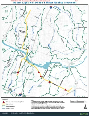
S1StStEMartinLutherKingJrBlvdE38ThStSLamarBlvdWMartinLutherKingJrBlvdNLamarBlvdW38ThStAirportBlvdW6ThStW15ThStS6ThStWRiversideDrE15ThStCarsonCreekBlunnCreekEastBouldinCreekShoalCreekCountryClubCreekWallerCreekTannehillBranchBoggyCreek7112901833535CountryClub EastBlunn CreekWalnutCreekEastBouldinCreekCountryClub WestWilliamsonCreekTannehillBranchColoradoRiverBartonCreekShoal CreekFort BranchHarpersBranchJohnson CreekWaller CreekTaylorSloughSouthCarson CreekLittleWalnutCreekLady BirdLakeWestBouldinCreekBoggy CreekDeliberative Draft: Not for Distribution2/24/202600.51MilesAustin Light Rail Phase 1 Water Quality TreatmentWatershed BoundaryLight Rail RoutePotential Location for Water Quality PondsLegendStreams & CreeksDeliberative Draft: Not for Distribution2/24/2026E Riverside DrS Congress AveLake BirdLakeColoradoRiverNotes:1. Potential locations for water quality ponds are identified per the FinalEnvironmental Impact Statement (FEIS). Proposed water quality ponds aresubject to change during final design.2. Additional treatment measures may include innovative/distributedinfrastructure such as bioswales, vegetative filter strips, and rain gardens.3. Comprehensive water quality treatment plan will be coordinated betweenAustin Transit Partnership (ATP) and Austin Watershed Protection (AWP).Trinity StS Pleasant Valley RdMontopolis DrGuadalupe StW 3rd St18 C20-2026-003 - Amendments Related to Transit System Projects1 of 1