16 SP-2024-0381C.SH - Rundberg Multifamily; District 4 - Staff Report Part 1 — original pdf
Backup
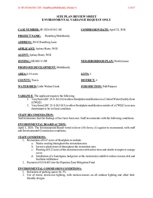
SITE PLAN REVIEW SHEET ENVIRONMENTAL VARIANCE REQUEST ONLY CASE NUMBER: SP-2024-0381C.SH COMMISSION DATE: April 28, 2026 PROJECT NAME: Rundberg Multifamily ADDRESS: 204 E Rundberg Lane APPLICANT: Sydney Barre, WGI AGENT: Sydney Barre, WGI ZONING: GR-MU-V-NP NEIGHBORHOOD PLAN: North Lamar PROPOSED DEVELOPMENT: Multifamily AREA: 6.54 acres COUNTY: Travis LOTS: 1 DISTRICT: 4 WATERSHED: Little Walnut Creek JURISDICTION: Full-Purpose VARIANCE: The applicant requests the following 1. Vary from LDC 25-8-261 (G) to allow floodplain modification in a Critical Water Quality Zone (CWQZ) 2. Vary from LDC 25-8-263 ©(3) to allow floodplain modification outside of a CWQZ in an area determined to be in Good condition STAFF RECOMENDATION: Staff determines that the findings of fact have been met. Staff recommends with the following conditions: ENVIRONMENTAL BOARD ACTION: April 1, 2026: The Environmental Board voted in favor (10) favor, (1) against to recommend, with staff and Environmental Commission conditions. STAFF CONDITIONS: 1. Restoration of 0.67 acres of floodplain to include: a. Native seeding throughout the restoration area b. c. Planting of 0.22 acres of the restoration area with native trees and shrubs to improve canopy Invasive plant removal throughout the restoration area d. cover Installation of a bunchgrass hedgerow at the stormwater outfall to reduce erosion risk and facilitate infiltration 2. Payment of $119,403 into the Riparian Zone Mitigation Fund ENVIRONMENTAL COMMISSION CONDITIONS: 1. Reduction of parking spaces by 5% 2. Use of warm, down-cast lighting, with motion-sensors on all outdoor lighting and other bird- friendly designs 16 SP-2024-0381C.SH - Rundberg Multifamily; District 41 of 67 ENVIRONMENTAL REVIEW STAFF: John Clement 512-974-1475 EMAIL: John.Clement@austintexas.gov CASE MANAGER: Chris Sapuppo 512-978-4665 EMAIL: Chris.Sapuppo@austintexas.gov ATTACHMENTS: Environmental Commission Recommendation Environmental Commission Backup 16 SP-2024-0381C.SH - Rundberg Multifamily; District 42 of 67 . RECOMMENDATION TO COUNCIL Environmental Commission Recommendation 20260401-003: SP-2024-0381C.SH Rundberg Multifamily WHEREAS, the Environmental Commission recognizes the applicant, Sydney Barre, WGI, has submitted a variance request located at 204 East Rundberg Lane; and WHEREAS, the Environmental Commission recognizes the site is located in Little Walnut Creek Watershed; and WHEREAS, the Environmental Commission recognizes that staff recommends this variance request. NOW, THEREFORE, BE IT RESOLVED the Environmental Commission recommends the Rundberg Multifamily variance request with the following conditions: Staff Conditions: • Restoration of 0.67 acres of floodplain to include: o Native seeding throughout the restoration area o o Planting of 0.22 acres of the restoration area with native trees and shrubs to Invasive plant removal throughout the restoration area o improve canopy cover Installation of a bunchgrass hedgerow at the stormwater outfall to reduce erosion risk and facilitate infiltration • Payment of $119,403 into the Riparian Zone Mitigation Fund Environmental Commission Conditions: • Reduction of parking spaces by 5% • Use of warm, down-cast lighting, with motion-sensors on all outdoor lighting and other bird- friendly designs Date of Approval: April 1, 2026 Motioned By: Secretary Qureshi Seconded By: Commissioner Luecke Vote: 10-1 16 SP-2024-0381C.SH - Rundberg Multifamily; District 43 of 67 . For: Vice Chair Krueger, Secretary Qureshi, Commissioner Brimer, Commissioner Changsut, Commissioner Fierro, Commissioner Fleury, Commissioner Luecke, Commissioner Moretta-Urdiales, Commissioner Morrison, Commissioner Sullivan Against: Chair Bristol Abstain: None Off the dais: None Absent: None Attest: _____________________________________________ Mariana Krueger, Vice Chair 16 SP-2024-0381C.SH - Rundberg Multifamily; District 44 of 67 Austin Watershed Protection Staff Recommendations Concerning Required Findings Project Name: Rundberg Multifamily, SP-2024-0381C.SH Ordinance Standard: Watershed Protection Ordinance (current code) Variance Request: • Request to vary from LDC 25-8-261 (G) to allow floodplain modification in a Critical Water Quality Zone (CWQZ) • Request to vary from LDC 25-8-263(C)(3) to allow floodplain modification outside of a CWQZ in an area determined to be in Good condition. A. Land Use Commission variance determinations from Chapter 25-8-41 of the City Code: 1. The requirement will deprive the applicant of a privilege available to owners of other similarly situated property with approximately contemporaneous development; Yes The project proposes 199 units of affordable housing facilitated through the SMART Housing and Affordability Unlocked programs. The site is uniquely situated on an Imagine Austin growth corridor and adjacent to a public elementary school. The on-site parking needed to serve the high density of affordable housing proposed necessitates expanding the development footprint into the floodplain and further modification of the floodplain, including a small portion of Critical Water Quality Zone (CWQZ), to compensate for the displaced flood volume. The site is further constrained by fire lane requirements for the adjacent shared private driveway which prohibits street parking on the driveway. 2. The variance: a. Is not based on a condition caused by the method chosen by the applicant to develop the property, unless the development method provides greater overall environmental protection than is achievable without the variance; Yes The project will reduce the total width of the floodplain but improves environmental protection by 1) benching a portion of the remaining floodplain, 2) increasing the density and diversity of native vegetation, 3) removing the dominant invasive understory vegetation, and 4) provide additional protection by installing a native bunchgrass hedgerow at the stormwater outfall. b. Is the minimum change necessary to avoid the deprivation of a privilege given to other property owners and to allow a reasonable use of the property; and 16 SP-2024-0381C.SH - Rundberg Multifamily; District 45 of 67 Yes The project proposes 199 units of affordable housing facilitated through the SMART Housing and Affordability Unlocked programs. The site is uniquely situated on an Imagine Austin growth corridor and adjacent to a public elementary school. The on-site parking needed to serve the high density of affordable housing proposed necessitates expanding the development footprint into the floodplain and further modification of the floodplain, including a small portion of Critical Water Quality Zone (CWQZ), to compensate for the displaced flood volume. The site is further constrained by fire lane requirements for the adjacent shared private driveway which prohibits street parking on the driveway. c. Does not create a significant probability of harmful environmental consequences; and Yes The project minimizes the potential for environmental consequences by reducing the overall width of the floodplain while improving floodplain health in the remaining portions and minimizing impacts to the CWQZ. 3. Development with the variance will result in water quality that is at least equal to the water quality achievable without the variance. Yes Standard water quality facilities will be provided and the floodplain modifications have been designed to minimize the potential for sediment impacts to the creek during construction. B. Additional Land Use Commission variance determinations for a requirement of Article 7, Division 1 (Waterway and Floodplain Protection): 1. The criteria for granting a variance in Subsection (A) are met; Yes 2. The requirement for which a variance is requested prevents a reasonable, economic use of the entire property; Yes The project proposes 199 units of affordable housing facilitated through the SMART Housing and Affordability Unlocked programs. The site is uniquely situated on an Imagine Austin growth corridor and adjacent to a public elementary school. The on-site parking needed to serve the high density of affordable housing proposed necessitates expanding the development footprint into the floodplain and further modification of the floodplain, including a small portion of Critical Water Quality Zone (CWQZ), to compensate for the displaced flood volume. The site is further constrained by fire lane requirements for the adjacent shared private driveway which prohibits street parking on the driveway. 3. The variance is the minimum deviation from the code requirement necessary to allow a reasonable, economic use of the entire property. 16 SP-2024-0381C.SH - Rundberg Multifamily; District 46 of 67 Yes The project proposes 199 units of affordable housing facilitated through the SMART Housing and Affordability Unlocked programs. The site is uniquely situated on an Imagine Austin growth corridor and adjacent to a public elementary school. The on-site parking needed to serve the high density of affordable housing proposed necessitates expanding the development footprint into the floodplain and further modification of the floodplain, including a small portion of Critical Water Quality Zone (CWQZ), to compensate for the displaced flood volume. The site is further constrained by fire lane requirements for the adjacent shared private driveway which prohibits street parking on the driveway. Staff Determination: Staff determines that the findings of fact have been met. Staff recommends with the following conditions: 1. Restoration of 0.67 acres of floodplain to include: a. Native seeding throughout the restoration area b. Invasive plant removal throughout the restoration area c. Planting of 0.22 acres of the restoration area with native trees and shrubs to improve canopy cover d. Installation of a bunchgrass hedgerow at the stormwater outfall to reduce erosion risk and facilitate infiltration 2. Floodplain modification must minimize impacts to the Critical Water Quality Zone 3. Floodplain modification must improve engagement of the floodplain during smaller storm events 4. Payment of $119,403 into the Riparian Zone Mitigation Fund Wetland Biologist / Hydrogeologist Reviewer (WPD) _____________________________ John Clement Date 3/13/26 Environmental Officer (WPD) _____________________________ Liz Johnston Date 03/25/2026 16 SP-2024-0381C.SH - Rundberg Multifamily; District 47 of 67 ITEM FOR ENVIRONMENTAL COMMISSION AGENDA COMMISSION MEETING DATE: NAME & NUMBER OF PROJECT: NAME OF APPLICANT OR ORGANIZATION: April 1, 2026 Rundberg Multifamily, SP-2024-0381C.SH Sydney Barre, WGI LOCATION: 204 East Rundberg Lane COUNCIL DISTRICT: 4 ENVIRONMENTAL REVIEW STAFF: John Clement, Environmental Conservation Program Manager, Austin Watershed Protection, 512-974-1475, John.Clement@austintexas.gov WATERSHED: Little Walnut Creek REQUEST: • Request to vary from LDC 25-8-261 (G) to allow floodplain modification in a Critical Water Quality Zone (CWQZ) • Request to vary from LDC 25-8-263(C)(3) to allow floodplain modification outside of a CWQZ in an area determined to be in Good condition. 16 SP-2024-0381C.SH - Rundberg Multifamily; District 48 of 67 STAFF RECOMMENDATION: Recommended with conditions. STAFF CONDITIONS: Staff recommends the following conditions: • Restoration of 0.67 acres of floodplain to include: o Native seeding throughout the restoration area Invasive plant removal throughout the restoration area o o Planting of 0.22 acres of the restoration area with native trees and shrubs to improve canopy cover Installation of a bunchgrass hedgerow at the stormwater outfall to reduce erosion risk and facilitate infiltration o • Payment of $119,403 into the Riparian Zone Mitigation Fund 16 SP-2024-0381C.SH - Rundberg Multifamily; District 49 of 67 Rundberg Multifamily SP-2024-0381C.SH Austin Watershed Protection | 4/1/26 John Clement 16 SP-2024-0381C.SH - Rundberg Multifamily; District 410 of 67 Rundberg Multifamily Property Data • Little Walnut Creek Watershed • Urban Watershed Regulation Area • No Critical Environmental Features on site • Council District 4 2 16 SP-2024-0381C.SH - Rundberg Multifamily; District 411 of 67 Rundberg Multifamily Project Background • Currently undeveloped • Proposes 199 units of affordable housing through the Affordability Unlocked and SMART Housing programs, with more than 50% of units having 3 or more bedrooms • The site is on an Imagine Austin Corridor and adjacent to an elementary school • The site is constrained by parking needs of the development and total lack of nearby street parking • Variance would allow full build-out of the site by permitting modification of a portion of the floodplain 3 16 SP-2024-0381C.SH - Rundberg Multifamily; District 412 of 67 Rundberg Multifamily Variance Request 1. Request to vary from LDC 25-8-261 (G) to allow floodplain modification in a Critical Water Quality Zone (CWQZ) 2. Request to vary from LDC 25-8-263(C)(3) to allow floodplain modification outside of a CWQZ in an area determined to be in Good condition. 4 16 SP-2024-0381C.SH - Rundberg Multifamily; District 413 of 67 Rundberg Multifamily Location 5 16 SP-2024-0381C.SH - Rundberg Multifamily; District 414 of 67 Rundberg Multifamily Site Plan 6 16 SP-2024-0381C.SH - Rundberg Multifamily; District 415 of 67 Rundberg Multifamily Floodplain Modification 0.72 acres 7 16 SP-2024-0381C.SH - Rundberg Multifamily; District 416 of 67 Rundberg Multifamily Floodplain Health • Floodplain is in “Good” condition due to high canopy/understory cover • However, much of that cover is invasive and the creek typically has little to no base flow • The modification and associated restoration will increase the riparian character of the creek by benching a portion of the floodplain, increase native diversity, managing invasive species, and providing additional stormwater protection 8 16 SP-2024-0381C.SH - Rundberg Multifamily; District 417 of 67 Rundberg Multifamily Floodplain Restoration 9 16 SP-2024-0381C.SH - Rundberg Multifamily; District 418 of 67 Rundberg Multifamily Floodplain Restoration 10 16 SP-2024-0381C.SH - Rundberg Multifamily; District 419 of 67 Rundberg Multifamily Floodplain Restoration – Stormwater Protection 11 16 SP-2024-0381C.SH - Rundberg Multifamily; District 420 of 67 Rundberg Multifamily Summary • • • • • Project proposes to modify 0.66 acres of floodplain outside of the CWQZ and 0.06 acres of floodplain inside of the CWQZ Areas are currently in Good condition per the Functional Assessment of Floodplain Health Project proposes 0.55 acres of floodplain restoration outside of the CWQZ and 0.12 acres of restoration inside the CWQZ Restoration will consist of increasing floodplain connectivity, managing invasive species, providing additional stormwater protection and increasing native diversity through planting and seeding Project proposes to meet remaining mitigation requirements by paying $119,403 into the Riparian Zone Mitigation Fund 12 16 SP-2024-0381C.SH - Rundberg Multifamily; District 421 of 67 Rundberg Multifamily Staff Determination – approval with conditions 1) Restoration of 0.67 acres of floodplain to include: a) Native seeding throughout the restoration area b) c) Planting of 0.22 acres of the restoration area with native trees and shrubs to improve canopy Invasive plant removal throughout the restoration area d) cover Installation of a bunchgrass hedgerow at the stormwater outfall to reduce erosion risk and facilitate infiltration 2) Floodplain modification must minimize impacts to the Critical Water Quality Zone 3) Floodplain modification must improve engagement of the floodplain during smaller storm events 4) Payment of $119,403 into the Riparian Zone Mitigation Fund 13 16 SP-2024-0381C.SH - Rundberg Multifamily; District 422 of 67 February 4, 2026 ENVIRONMENTAL COMMISSION VARIANCE APPLICATION FORM PROJECT DESCRIPTION Applicant Contact Information Name of Applicant Street Address City State ZIP Code Work Phone E-Mail Address Sydney Barre 4700 Mueller Blvd, Suite 300 Austin, Texas 78723 512-669-5560 Sydney.Barre@wginc.com Variance Case Information Case Name Case Number Address or Location Environmental Reviewer Name Environmental Resource Management Reviewer Name Applicable Ordinance Rundberg Multifamily SP-2024-0381C.SH 204 E. Rundberg Lane David Michael John Clement LDC 25-8-261 (G) and LDC LDC 25-8-263(C)(3) Watershed Name Little Walnut Creek Watershed Classification X Urban ☐ Suburban ☐ Water Supply Suburban ☐Water Supply Rural ☐ Barton Springs Zone City of Austin | Environmental Commission Variance Application Guide 1 16 SP-2024-0381C.SH - Rundberg Multifamily; District 423 of 67 February 4, 2026 Edwards Aquifer Recharge Zone ☐ Barton Springs Segment ☐ Northern Edwards Segment X Not in Edwards Aquifer Zones Edwards Aquifer Contributing Zone Distance to Nearest Classified Waterway ☐ Yes X No The centerline of Little Walnut Creek is located north of the subject property and clips the property boundary at the northeast corner of the parcel according to COA GIS. Water and Waste Water service to be provided by Austin Water Utility (AWU) Request Impervious cover square footage: acreage: percentage: Provide general description of the property (slope range, elevation range, summary of vegetation / trees, summary of the geology, CWQZ, WQTZ, CEFs, floodplain, heritage trees, any other notable or outstanding characteristics of the property) The variance request is as follows (Cite code references: Floodplain modification in the COA fully developed floodplain and CWQZ (LDC 25-8- 261(G)) and floodplain modification outside of the CWQZ with a FAFH score of good (LDC 25-8-263(C)(3)). Existing ____0____ ____0____ ____0____ Proposed ____185,173 SF__ _____4.251 ac___ ____65.01%_____ The proposed development for the site is a 199-unit affordable multifamily development located at 204 E. Rundberg Lane. The total site area is +/- 6.54 acres and is currently undeveloped. The existing topography ranges from roughly 688 to 664 and there is one heritage tree located on site that is being preserved. There are primary Cedar and Hackberry trees located on site that are being preserved where feasible for development. There are no CEFs identified on the project site. While there is no FEMA delineated floodplain on site, there is City of Austin 25-yr and 100-yr full developed floodplain that crosses the northern border of the site due to the offsite contributing area greater than 64 acres immediately upstream. The offsite contributing area is routed along the northern border of the site and conveyed to existing box culverts under North Creek Drive. There is a portion of CWQZ that clips the northeast corner of the property boundary of the site. City of Austin | Environmental Commission Variance Application Guide 2 16 SP-2024-0381C.SH - Rundberg Multifamily; District 424 of 67 February 4, 2026 Clearly indicate in what way the proposed project does not comply with current Code (include maps and exhibits) FINDINGS OF FACT The project proposes modifications within the floodplain and CWQZ and the floodplain has a FAFH score of good. As required in LDC Section 25-8-41, in order to grant a variance the Land Use Commission must make the following findings of fact: Include an explanation with each applicable finding of fact. Project: Ordinance: A. Land Use Commission variance determinations from Chapter 25-8-41 of the City Code: 1. The requirement will deprive the applicant of a privilege available to owners of similarly situated property with approximately contemporaneous development subject to similar code requirements. Yes Based on the existing topography on site and the existing drainage channels that traverse the site, the floodplain and setbacks that are generated limit the available developable areas. In order to generate buildable areas on site it is necessary to modify the floodplain, by adding fill within the existing floodplain and provide mitigation plantings in this area. The proposed fill modifies the floodplain, so the stormwater is contained within a closer proximity to the drainage channel and is able to be contained within a proposed drainage easement. 2. The variance: a) Is not necessitated by the scale, layout, construction method, or other design decision made by the applicant, unless the design decision provides greater overall environmental protection than is achievable without the variance; Yes City of Austin | Environmental Commission Variance Application Guide 3 16 SP-2024-0381C.SH - Rundberg Multifamily; District 425 of 67 February 4, 2026 Rundberg Multifamily is a SMART Housing and Affordability Unlocked multifamily residential development that is designed generally preserve the natural drainage patterns and follow existing topography. The water quality and detention basins are strategically located within natural low areas to maintain the existing drainage patterns and outfall to the lowest point on site. The project provides additional mitigation plantings within the floodplain, both inside and outside of the CWQZ, to enhance ecological function in addition to contributing to the city’s mitigation fund. This variance reflects over a year of close coordination and guidance with city staff, and all design decisions have been made with the requirements and intent of the city code in mind. b) Is the minimum deviation from the code requirement necessary to allow a reasonable use of the property; Yes Rundberg Multifamily has been designed to minimally deviate from the code to allow for maximum preservation of the CWQZ and floodplain areas. The site layout considered the buffer areas and minimized improvements within them to only the fill of the floodplain which will provide a more defined floodplain within the drainage channel. This deviation allows development of the site providing affordable residential units to north Austin and improves the health and safety of the area with the more defined floodplain. Diverse mitigation plantings are also provided to enhance the floodplain. c) Does not create a significant probability of harmful environmental consequences. Yes All contributing drainage basins from this site receive necessary water quality treatment prior to entering the drainage channel which helps promote a healthy floodplain. The cut and fill proposed within this site’s floodplain boundary are designed to minimize impacts to all upstream and downstream properties, and the proposed design provides mitigation plantings that will restore the environmental area and strive to improve the conditions that exist on site. 3. Development with the variance will result in water quality that is at least equal to the water quality achievable without the variance. Yes The proposed design preserves the natural drainage patterns by providing water quality and detention ponds along the northern portion of the site. Regardless of this floodplain City of Austin | Environmental Commission Variance Application Guide 4 16 SP-2024-0381C.SH - Rundberg Multifamily; District 426 of 67 February 4, 2026 variance application, with the site constraints and site configuration, there is limited space for the large volume of water quality needed so water quality treatment is proposed within an underground partial sedimentation-filtration pond. The proposed landscape plan includes trees and plantings throughout the site helping to provide a nature-focused experience for residents. All design decisions have been made with the requirements and intent of the city environmental code in mind. B. Additional Land Use Commission variance determinations for a requirement of Section 25-8-422 (Water Quality Transition Zone), Section 25-8-452 (Water Quality Transition Zone), Article 7, Division 1 (Critical Water Quality Zone Restrictions), or Section 25-8-368 (Restrictions on Development Impacting Lake Austin, Lady Bird Lake, and Lake Walter E. Long): 1. The criteria for granting a variance in Subsection (A) are met; Yes There is no Water Quality Transition Zone located on the property, and it does not impact Lake Austin, Lady Bird Lake, or Lake Walter E. Long. 2. The requirement for which a variance is requested prevents a reasonable, economic use of the entire property; Yes Modification in the CWQZ and City of Austin floodplain are required to be able to make reasonable use of the property allowing for the affordable multifamily development. There is no Water Quality Transition Zone located on the property, and it does not impact Lake Austin, Lady Bird Lake, or Lake Walter E. Long. 3. The variance is the minimum deviation from the code requirement necessary to allow a reasonable, economic use of the entire property. Yes The proposed site plan was laid out with the CWQZ and floodplain in mind. Design considerations were made to be able to preserve natural areas to the full extent possible while still allowing for reasonable use of the entire property. **Variance approval requires all above affirmative findings. City of Austin | Environmental Commission Variance Application Guide 5 16 SP-2024-0381C.SH - Rundberg Multifamily; District 427 of 67 February 4, 2026 A Exhibits for Commission Variance o Aerial photos of the site o Site photos o Aerial photos of the vicinity o Context Map—A map illustrating the subject property in relation to developments in the vicinity to include nearby major streets and waterways o Topographic Map - A topographic map is recommended if a significant grade change on the subject site exists or if there is a significant difference in grade in relation to adjacent properties. o For cut/fill variances, a plan sheet showing areas and depth of cut/fill with topographic elevations. o Site plan showing existing conditions if development exists currently on the property o Proposed Site Plan- full size electronic or at least legible 11x17 showing proposed development, include tree survey if required as part of site or subdivision plan o Environmental Map – A map that shows pertinent features including Floodplain, CWQZ, WQTZ, CEFs, Setbacks, Recharge Zone, etc. o An Environmental Resource Inventory pursuant to ECM 1.3.0 (if required by 25-8-121) o Applicant’s variance request letter City of Austin | Environmental Commission Variance Application Guide 6 16 SP-2024-0381C.SH - Rundberg Multifamily; District 428 of 67 Property Profile Aerial Photo Legend Property Street Labels Appraisal Districts TCAD Parcels 0 450 900 ft 12/9/2025 This product is for informational purposes and may not have been prepared for or be suitable for legal, engineering, or surveying purposes. It does not represent an on-the-ground survey. This product has been produced by the City of Austin for the sole purpose of geographic reference. No warranty is made by the City of Austin regarding specific accuracy or completeness. Notes 16 SP-2024-0381C.SH - Rundberg Multifamily; District 429 of 67 Photo#: 1 Date Taken: 2/28/2024 Description: Typical view of the central portion of subject property showing the dirt paths. Photo#: 2 Date Taken: 2/28/2024 Description: View of drainage culvert to northwest of the subject property Photo Log PE 202402082 SITE PHOTOS16 SP-2024-0381C.SH - Rundberg Multifamily; District 430 of 67 Photo#: 3 Date Taken: 2/28/2024 Description: View to east of culvert toward drainage path showing erosion due to stormwater flow Photo#: 4 Date Taken: 2/28/2024 Description: View of channel east of the culvert Photo Log PE 202402082 16 SP-2024-0381C.SH - Rundberg Multifamily; District 431 of 67 Photo#: 5 Date Taken: 2/28/2024 Description: View of water transported trash and debris on the north adjoining property. The bed and bank of the stream channel was not evident in this area. Photo#: 6 Date Taken: 2/28/2024 Description: View of stream bed which reappeared north of the northeast corner of the subject property. Exposed roots and large boulders are visible along the bank. Photo Log PE 202402082 16 SP-2024-0381C.SH - Rundberg Multifamily; District 432 of 67 Photo#: 7 Date Taken: 2/28/2024 Description: View of stream bed crossing the northeast corner of the subject property. Photo#: 8 Date Taken: 2/28/2024 Description: View of erosion and bank failure along the stream behind the adjoining single-family homes on the east adjoining properties. A small amount of water has ponded in this section of the stream bed only. Photo Log PE 202402082 16 SP-2024-0381C.SH - Rundberg Multifamily; District 433 of 67 Property Profile Context Map Legend Property Street Labels Jurisdiction Boundary FULL PURPOSE LIMITED PURPOSE EXTRATERRITORIAL JURISDICTION EXTRATERRITORIAL JURISDICTION EXTRATERRITORIAL JURISDICTION 2 MILE ETJ AGRICULTURAL AGREEMENT OTHER CITY LIMITS OTHER CITY LIMITS OTHER CITIES ETJ OTHER CITIES ETJ Appraisal Districts TCAD Parcels Environmental Features Creek Centerlines Notes 0 500 1000 ft 11/26/2025 This product is for informational purposes and may not have been prepared for or be suitable for legal, engineering, or surveying purposes. It does not represent an on-the-ground survey. This product has been produced by the City of Austin for the sole purpose of geographic reference. No warranty is made by the City of Austin regarding specific accuracy or completeness. 16 SP-2024-0381C.SH - Rundberg Multifamily; District 434 of 67 G F E D C B A GEORGIAN DR. (55' R.O.W.- ASPHALT) AUSTIN I.S.D. ACCESS EASEMENT DOC. #2012171476 SD SD ACCESS EASEMENT AGREEMENT CALLED 0.576 OF AN ACRE DOC. #2011163882 ACCESS EASEMENT AGREEMENT CALLED 0.576 OF AN ACRE DOC. #2011163882 N27°35'34"E 779.67' L=124.52' R=1675.88' D=4°15'25" T=62.29' CHORD=N59°41'44"W 124.49' NORTH DR. (50' R.O.W.- ASPHALT) . N L G R E B D N U R . E ) T L A H P S A - S E I R A V . . W O R ( . DELINEATED PRE-DEVELOPMENT ATLAS 14 25-YR FLOODPLAIN DELINEATED PRE-DEVELOPMENT ATLAS 14 100-YR FLOODPLAIN 10' WASTEWATER ESMT. CITY OF AUSTIN VOL. 8093, PG. 313 FLOODPLAIN DRAINAGE EASEMENT DOC. NO. 2013003944 ' 0 0 . 3 7 3 ' E " 1 2 2 3 ° 2 6 S S27°23'09"W 179.02' ' 7 0 . 0 5 ' W " 9 0 1 0 ° 2 6 N 5' P.U.E. VOL. 47, PG. 13 S27°27'58"W 609.63' 5' P.U.E. VOL. 47, PG. 13 37.5' DRAINAGE ESMT. VOL. 47, PG. 13 NORTH CREEK DR. (40' R.O.W.- ASPHALT) ' 8 5 . 0 0 2 ' W " 6 5 1 5 ° 1 6 N ) 7 8 7 1 . G P , 7 6 0 5 . L O V ( 5 4 3 2 1 0 0 1 C \ g w d . L L A R E V O - S N O I T I D N O C G N I T S I X E - 1 0 0 . 0 4 . 3 1 3 0 \ s t h S - 0 2 \ D A C - 0 1 \ L I V I C \ m a f m g r e b d n u r g c e 0 0 . 3 2 5 0 1 \ 0 0 5 0 1 \ s t c e j o r P \ a t a d \ m o c . i g w \ \ : G N I W A R D M A 7 3 : 0 1 6 2 / 1 1 / 5 2 0 2 : E T A D T O L P e r r a B y e n d y S : Y B D E T T O L P M P 8 2 : 3 4 0 / 1 1 / 5 2 0 2 : D E V A S R O F D E Z I R O H T U A T O N O T R O I R P N O I T C U R T S N O C L A V O R P P A Y T I C L A M R O F 3 2 7 8 7 , S A X E T , N I T S U A , 0 0 3 E T I U S , D V L B R E L L E U M 0 0 7 4 LEGEND BOUNDARY / RIGHT OF WAY LIMITS OF SURVEY. REF. NOTE #2 CURB / EDGE OF PAVEMENT CONTOUR (GRADE) ELEVATIONS SHEET METAL FENCE WROUGHT IRON FENCE WOOD FENCE CHAIN-LINK FENCE WATER LINE WASTEWATER LINE OVERHEAD ELECTRIC UNDERGROUND ELECTRIC UNDERGROUND TELECOM GAS LINE CRITICAL WATER QUALITY ZONE EROSION HAZARD ZONE 100-YR FLOOD PLAIN - ATLAS 14 500-YR FLOOD PLAIN - COA ADA ACCESSIBLE ROUTE UTILITY / LIGHT POLE POLE MOUNTED TRANSFORMER GUY WIRE ELECTRIC / TELECOM RISER ELECTRIC / TELECOM MANHOLE TELECOM PULL-BOX CLEAN-OUT WASTEWATER MANHOLE STORM DRAIN MANHOLE / INLET ROD / NAIL FOUND OR SET SIGN WATER METER VAULT WATER VALVE FIRE HYDRANT 1 2 CRITICAL ROOT ZONE TREE W/ TAG NUMBER CROSS HATCH INDICATES HERITAGE TREE 5 8 0 5 1 - F : O N M R I F 0 6 5 5 . 9 6 6 . 2 1 5 OVERALL SHEET NOTE: THIS SHEET IS FOR REFERENCE ONLY. SEE EXISTING CONDITIONS SHEETS A AND B FOR MORE DETAILED INFORMATION. LEGAL DESCRIPTION: 6.5432 ACRES, 24.2458 ACRE TRACT OUT OF THE JOHN APPLEGATE SURVEY NO.58, ABSTRACT NO. 29, SAVE AND EXCEPT A 17.702 ACRE TRACT OF LAND IN THE JOHN APPLEGATE SURVEY NO. 58, ABSTRACT NO. 29 IN TRAVIS COUNTY DEED RECORDS ON AUGUST 19, 2011. BEARING BASIS: COORDINATES AND BEARINGS ARE BASED UPON THE TEXAS COORDINATE SYSTEM, CENTRAL ZONE 4203, NORTH AMERICAN DATUM OF 1983 (NAD 83), 2011 ADJUSTMENT, EPOCH 2010.00. FLOODPLAIN NOTE: THIS PROPERTY LIES IN UNSHADED ZONE "X", AS DELINEATED ON THE FLOOD INSURANCE RATE MAP FOR TRAVIS COUNTY, TEXAS AND INCORPORATED AREAS, MAP NO. 48453C0455J, MAP DATED JANUARY 6, 2016. LAND USE SUMMARY: GR-MU-V-NP ZONING: MULTIFAMILY PROPOSED SITE USE: GROSS ACREAGE: 6.444 AC. LIMITS OF CONSTRUCTION: 6.892 AC. RECHARGE ZONE: THIS PROJECT IS NOT LOCATED WITHIN THE EDWARDS AQUIFER TRANSITION ZONE. WATERSHED: THIS PROJECT IS LOCATED IN THE LITTLE WALNUT CREEK WATERSHED (CLASSIFICATION: URBAN). NOTES: 1. EXISTING CONDITIONS SURVEY PREPARED BY SUMMIT GEOMATICS, INC. ON MARCH 12, 2024. 2. AREAS OUTSIDE THE "LIMITS OF SURVEY" WERE PREPARED WITHOUT THE BENEFIT OF A DESIGN SURVEY. ALL EXISTING IMPROVEMENTS AND TOPOGRAPHIC ELEVATIONS OUTSIDE THE "LIMITS OF SURVEY" WERE LOCATED USING RECORD CITY MAPS, GIS INFORMATION AND PHOTOGRAPHS. LOCATIONS OF EXISTING UTILITIES, SOME OF WHICH MAY NOT BE SHOWN, COULD IMPACT CONSTRUCTION MEANS AND METHODS. INITIAL SUBMITTAL 10/23/2024 Y L I M A F I T L U M G R E B D N U R . N L G R E B D N U R . E 4 0 2 3 5 7 8 7 S A X E T , Y T N U O C S I V A R T , N I T S U A F O Y T I C S N O I T I D N O C G N I T S I X E L L A R E V O 3. ONLY VISIBLE IMPROVEMENTS & UTILITIES WERE PROVIDED FROM CITY APPROVAL STAMP SURVEY (THE SURVEYOR/ENGINEER HAS NOT PHYSICALLY LOCATED THE UNDERGROUND UTILITIES). LOCATIONS OF EXISTING UTILITIES, SOME OF WHICH MAY NOT BE SHOWN, COULD IMPACT CONSTRUCTION MEANS AND METHODS. CONTRACTOR TO VERIFY ALL EXISTING UTILITIES VERTICALLY AND HORIZONTALLY PRIOR TO BID & CONSTRUCTION, AND SHALL NOTIFY THE ENGINEER IMMEDIATELY OF ANY DISCREPANCIES. THE CONTRACTOR TO CONTACT THE "ONE CALL" SYSTEM @ 811, OR THE OWNER OF EACH INDIVIDUAL UTILITY FOR ASSISTANCE IN DETERMINING EXISTING UTILITY LOCATIONS. 4. THE SIZE AND LOCATION OF UTILITY STRUCTURES, (IF SHOWN), MAY BE EXAGGERATED FOR GRAPHICAL CLARITY. THE SURVEY SHOWS FIELD MEASURED SIZES AND DEPTHS AS OBSERVED FROM GROUND LEVEL OPENINGS. 5. REFERENCE COVER SHEET FOR ADDITIONAL SITE INFORMATION. 6. LIMITS OF CONSTRUCTION ARE SHOWN ON THE EROSION AND SEDIMENTATION CONTROL PLANS. SHEET C100 06 OF 58 SP-2024-0381C.SH G F E D C B A 16 SP-2024-0381C.SH - Rundberg Multifamily; District 435 of 67 G F E D C B A NO. SIZE TYPE (BOLES) NO. SIZE TYPE (BOLES) NO. SIZE TYPE (BOLES) NO. SIZE TYPE (BOLES) NO. SIZE TYPE (BOLES) 9 16 13" BOX ELDER 8" CEDAR ELM 137 10" CEDAR ELM 200 9" HACKBERRY 501 17" CEDAR ELM (H) 502 24" CEDAR ELM (P) 503 19" AMERICAN ELM 504 18" CEDAR ELM 505 11" CEDAR ELM (P) 506 19" CEDAR ELM 507 12" CHINABERRY (8-8") 508 8" HACKBERRY 509 14" HACKBERRY 510 9" HACKBERRY 511 8" HACKBERRY 512 14" HACKBERRY (10-8") 513 8" HACKBERRY 514 515 9" HACKBERRY 16" CEDAR ELM 516 12" CEDAR 517 16" CEDAR 518 12" CEDAR (P) 519 19" LIGUSTRUM TREE (10-8-6-3") (P) 520 22" LIGUSTRUM TREE (8-6-6-6-5-2-2") (P) 521 24" LIGUSTRUM TREE (9-9-8-8-3") 522 17" CEDAR ELM 523 8" HACKBERRY 524 14" HACKBERRY 525 9" HACKBERRY 526 8" HACKBERRY 527 8" HACKBERRY 528 9" HACKBERRY 529 8" HACKBERRY 530 8" CEDAR ELM 531 14" HACKBERRY (9-9") 532 16" HACKBERRY (11-10") 533 13" HACKBERRY 534 8" CEDAR ELM 535 12" HACKBERRY (8-8") 536 9" HACKBERRY 537 8" HACKBERRY 538 10" CEDAR ELM 539 9" CEDAR ELM 540 8" CEDAR ELM 541 8" CEDAR 542 8" CEDAR 543 9" CEDAR 544 11" CEDAR 545 9" CEDAR 546 8" CEDAR 547 9" CEDAR 548 8" CEDAR 549 9" CEDAR 550 10" CEDAR 551 10" CEDAR (P) 552 24" CEDAR (11-6-5-5-5-4") (P) 553 20" CEDAR (8-7-7-5-4") 554 8" CEDAR ELM (P) 555 19" HACKBERRY (11-7-7") 556 9" HACKBERRY 557 8" HACKBERRY 558 9" CEDAR ELM 559 15" HACKBERRY (10-9") 560 11" HACKBERRY 561 8" HACKBERRY 562 10" HACKBERRY 563 8" CEDAR (P) 564 27" CEDAR (10-10-8-8-7") 565 17" CEDAR (10-7-7") 566 11" CEDAR 567 15" CEDAR (11-7") (P) 568 23" CEDAR (8-8-7-7-7") 569 12" CEDAR 570 18" CEDAR (13-9") (P) 571 25" CEDAR (11-10-10-7") 572 9" CEDAR (P) 573 21" CEDAR (13-8-8") (P) 574 29" CEDAR (12-12-11-10") (P) 575 20" CEDAR (10-8-6-5") (P) 576 21" CEDAR (12-7-5-5") 577 13" CEDAR 578 11" CEDAR 579 8" CEDAR 580 8" CEDAR 581 8" CEDAR 582 8" CEDAR (P) 583 25" CEDAR (12-10-9-7") 584 9" CEDAR 585 9" CEDAR 586 12" CEDAR (9-6") 587 8" CEDAR 588 17" CEDAR (9-6-5-4") 589 10" CEDAR 590 11" CEDAR (8-6") 591 12" CEDAR 592 8" CEDAR 593 9" CEDAR 594 9" CEDAR 595 8" CEDAR 596 8" CEDAR 597 9" HACKBERRY 598 9" CEDAR 599 9" CEDAR 600 8" CEDAR 701 8" HACKBERRY 702 9" HACKBERRY (P) 703 19" CEDAR ELM (P) 704 19" CEDAR ELM (P) 705 21" BOX ELDER 706 8" BOX ELDER 707 9" CEDAR ELM 708 10" HACKBERRY 709 9" HACKBERRY 710 10" CEDAR ELM 711 12" HACKBERRY 712 12" HACKBERRY 713 16" BOX ELDER 714 715 9" CEDAR ELM 9" HACKBERRY 716 13" HACKBERRY (10-6") 717 8" HACKBERRY 718 18" CEDAR ELM (15-5") 719 14" CEDAR ELM 720 10" CEDAR ELM 721 11" CEDAR ELM 722 8" CEDAR ELM 723 8" HACKBERRY 724 9" CEDAR ELM (P) 725 19" BOX ELDER (16-5") 726 8" CEDAR ELM 727 8" CEDAR ELM 728 14" CEDAR ELM 729 8" HACKBERRY 730 8" HACKBERRY 731 8" CEDAR 732 12" CEDAR ELM 733 11" CEDAR 734 11" CEDAR 735 8" HACKBERRY 736 8" CEDAR 737 8" OAK 738 10" CEDAR 739 11" CEDAR 740 11" CEDAR 741 12" CEDAR 742 8" CEDAR 743 8" CEDAR 744 8" CEDAR ELM 745 8" HACKBERRY 746 9" HACKBERRY 747 9" CEDAR ELM 748 10" HACKBERRY 749 11" CEDAR ELM 750 11" BOX ELDER 751 10" CEDAR ELM 752 9" CEDAR ELM 753 11" CEDAR ELM 754 11" HACKBERRY 755 16" OAK 756 9" HACKBERRY 757 9" BOX ELDER 758 14" HACKBERRY 759 14" CEDAR ELM 760 9" HACKBERRY 761 15" CEDAR (9-6-6") 762 12" CEDAR 763 11" CEDAR (8-6") 764 8" CEDAR 765 10" CEDAR 766 8" CEDAR 767 8" CEDAR 768 8" HACKBERRY 769 11" BOX ELDER 770 10" BOX ELDER (P) 771 21" HACKBERRY* 772 13" HACKBERRY 773 11" HACKBERRY 774 12" HACKBERRY 775 11" HACKBERRY 776 9" HACKBERRY 777 8" HACKBERRY 778 13" HACKBERRY (9-8") 779 10" HACKBERRY 780 8" HACKBERRY 781 8" HACKBERRY 782 12" HACKBERRY 783 11" HACKBERRY 784 12" CEDAR (8-8") 785 9" CEDAR 786 11" HACKBERRY (8-6") 787 11" HACKBERRY 788 14" HACKBERRY (10-8") 789 13" HACKBERRY 790 8" HACKBERRY 791 12" HACKBERRY (P) 792 19" HACKBERRY 793 17" HACKBERRY 905 9" CEDAR 906 10" CEDAR 907 9" CEDAR 908 8" CEDAR 909 10" CEDAR 910 8" CEDAR 911 8" CEDAR 912 9" CEDAR 913 8" CEDAR 914 10" CEDAR 915 9" CEDAR 916 10" CEDAR 917 8" CEDAR 918 12" CEDAR (9-5") 919 8" CEDAR 920 9" CEDAR 921 15" CEDAR (10-6-4") 922 11" CEDAR 923 8" CEDAR 924 10" CEDAR 925 9" CEDAR 926 8" CEDAR 927 8" CEDAR 997 8" CEDAR 998 10" CEDAR 999 17" CEDAR (12-10") 928 15" CEDAR (8-7-6") 1000 10" CEDAR 929 8" CEDAR 930 9" CEDAR 931 8" CEDAR 932 13" CEDAR (10-5") 933 8" CEDAR 934 10" CEDAR 935 11" CEDAR 936 15" CEDAR (11-8") 937 14" CEDAR 938 8" CEDAR 939 14" CEDAR 940 9" CEDAR 941 9" CEDAR 942 9" CEDAR 943 9" CEDAR 944 13" HACKBERRY (10-6") 945 8" CEDAR 946 9" CEDAR 947 9" HACKBERRY 948 8" CEDAR ELM 949 13" HACKBERRY (9-7") 950 11" LIGUSTRUM TREE (8-6") 951 12" CEDAR ELM (8-8") 952 11" CEDAR ELM 953 13" CEDAR ELM 954 8" CEDAR ELM 955 8" HACKBERRY 956 9" HACKBERRY 957 8" HACKBERRY 958 8" HACKBERRY 959 8" HACKBERRY 960 10" HACKBERRY 961 8" HACKBERRY 962 8" HACKBERRY 963 9" HACKBERRY 964 8" HACKBERRY 965 9" HACKBERRY 966 9" HACKBERRY 967 8" HACKBERRY 968 9" HACKBERRY 969 16" CEDAR ELM 970 8" HACKBERRY 971 13" CEDAR ELM 972 8" HACKBERRY 973 8" HACKBERRY 974 9" HACKBERRY 975 11" CEDAR ELM (8-3-2") (P) 976 20" MULLBERRY (12-8-8") 977 18" CEDAR ELM 978 8" HACKBERRY 979 9" HACKBERRY 980 16" HACKBERRY (11-9") 981 11" CEDAR ELM 982 11" CEDAR ELM 983 10" CEDAR ELM 984 8" HACKBERRY 985 10" CEDAR ELM 986 8" CEDAR ELM 987 8" CEDAR ELM 988 9" CEDAR ELM 989 36" COTTONWOOD 990 9" CEDAR ELM 991 12" CEDAR ELM (9-6") 992 12" HACKBERRY (8-7") 993 8" CEDAR ELM (P) 994 19" AMERICAN ELM 995 9" CEDAR 996 9" CEDAR NOTES & LEGEND: TREES WERE SURVEYED ON 03/12/2024 CRITICAL ROOT ZONES (TREE CIRCLES) ARE SHOWN USING THE COA FORMULA FOR SINGLE AND MULTI TRUNK TREES. NO. DIA. TYPE BOLES 100 12" CEDAR ELM (8-7-6") TREE TO REMAIN 100 12" CEDAR ELM (8-7-6") TREE TO BE REMOVED (P) PROTECTED TREE (H) HERITAGE TREE * TREE TO REMAIN BUT MITIGATION IS PROVIDED R O F D E Z I R O H T U A T O N O T R O I R P N O I T C U R T S N O C L A V O R P P A Y T I C L A M R O F 3 2 7 8 7 , S A X E T , N I T S U A , 0 0 3 E T I U S , D V L B R E L L E U M 0 0 7 4 5 8 0 5 1 - F : O N M R I F 0 6 5 5 . 9 6 6 . 2 1 5 INITIAL SUBMITTAL 10/23/2024 T S I L E E R T G N I T S I X E Y L I M A F I T L U M G R E B D N U R . N L G R E B D N U R . E 4 0 2 3 5 7 8 7 S A X E T , Y T N U O C S I V A R T , N I T S U A F O Y T I C CITY APPROVAL STAMP SHEET C103 10 OF 62 SP-2024-0381C.SH G F E D C B A 5 4 3 2 1 T S I L E E R T G N I T S I X E \ g w d . T S I L E E R T - 1 0 0 . 0 4 . 3 1 3 0 \ s t h S - 0 2 \ D A C - 0 1 \ L I V I C \ m a f m g r e b d n u r g c e 0 0 . 3 2 5 0 1 \ 0 0 5 0 1 \ s t c e j o r P \ a t a d \ m o c . i g w \ \ : G N I W A R D M P 5 5 : 4 4 1 / 1 0 / 6 2 0 2 : E T A D T O L P l z e a z n o G l i e n O : Y B D E T T O L P M P 1 3 : 4 8 0 / 1 0 / 6 2 0 2 : D E V A S 1/14/202616 SP-2024-0381C.SH - Rundberg Multifamily; District 436 of 67 G F E D C B A GEORGIAN DR. (55' R.O.W.- ASPHALT) LIMITS OF SURVEY REF. NOTE #2 ZONING: LR-MU-V-NP USE: OFFICE AW INT#4837 GRID L-30 13' STREET DEED DOC. NO.___________ 13'-0" ROW DEDICATION ' 2 5 . 4 2 1 = L ' 8 8 . 5 7 6 1 = R " 5 2 ' 5 1 ° 4 = D W " 4 4 ' ' 9 4 . 4 2 1 ' 9 2 . 2 6 = T 1 4 ° 9 5 N = D R O H C AW INT#4399 GRID L-30 EXIST. FH (102585) ' 8 5 . 0 0 2 ' W " 6 5 1 5 ° 1 6 N 13'-0" ROW DEDICATION PROP. ACCESS EASEMENT AGREEMENT DOC. #_________ AUSTIN I.S.D. FIRE LANE ACCESS EASEMENT DOC. #2012171476 FIRE LANE FIRE LANE FIRE LANE PROP. ACCESS FIRE LANE EASEMENT AGREEMENT DOC. #_________ ACCESS EASEMENT AGREEMENT CALLED 0.576 OF AN ACRE FIRE LANE DOC. #2011163882 FIRE LANE FIRE LANE FIRE LANE ZONING: SF-3-NP USE: OFFICE ' 1 8 . 5 2 FIRE LANE ' 2 8 . 3 1 ACCESS EASEMENT AGREEMENT CALLED 0.576 OF AN ACRE DOC. #2011163882 47.75' FIRE LANE E N27°35'34"E 779.67' SD FIRE LANE PROP. ACCESS EASEMENT AGREEMENT DOC. #_________ FIRE LANE FIRE LANE ' 2 . 6 1 332.65' 25' ADA ADA E 179.56' LIMITS OF SURVEY REF. NOTE #2 ' 1 0 . 2 7 CO ADA ADA ADA ADA ADA ADA ADA ADA ADA A D A A D A A D A A D A SD SD ADA ADA E N A L E R I F E N A L E R I F E N A L E R I F A D A A D A A D A A D A A D A A D A A D A A D A SD SD V F A I N R E L A N E WW F I R E L A N E CO F I R E L A N E F I R E L A N E ADA ADA L I A M N O I L L I V A P ' 4 5 . 0 8 BUILDING #1 4-STORY MULTIFAMILY 25,807 SF (COVERAGE) ADA ADA ADA POOL ' 3 7 . 9 6 2 ADA ADA ADA ADA EXIST. ZONING: SF-3-NP USE: VACANT PROP. ZONING: GR-MU-V USE: VACANT BUILDING #2 4-STORY MULTIFAMILY 37,862 SF (COVERAGE) ' 2 0 . 2 8 2 EXIST. ZONING: LR-V-NP USE: VACANT PROP. ZONING: GR-MU-V USE: VACANT ADA A D A A D A A D A A D A A D A A D A A D A E N A L E R I F E N A L E R I F E N A L E R I F E N A L E R I F F I R E L A N E F I R E L A N E 25' F I R E L A N E A D A A D A CO FIRE LANE ADA ADA 70.71' FIRE LANE FIRE LANE WW CO WW WW CO CO SD FIRE LANE FIRE LANE SD ADA ADA ADA FIRE LANE FIRE LANE FIRE LANE UNDERGROUND WATER QUALITY POND FIRE LANE FIRE LANE FIRE LANE FIRE LANE S D UNDERGROUND DETENTION POND PROP. DRAINAGE EASEMENT WITH REQUIRED MAINTENANCE DOC. NO. ________ A D A A D A A D A A D A S D S D SD SD SD S D SD 37.5' DRAINAGE ESMT. VOL. 47, PG. 13 NORTH DR. (50' R.O.W.- ASPHALT) 13' STREET DEED DOC. NO.___________ 10.23' WW 74.02' FIRE LANE FIRE LANE FIRE LANE FIRE LANE SD SD SD SD FIRE LANE WW FIRE LANE WW FIRE LANE FIRE LANE ADA ADA ADA ADA ADA ADA ADA A D A WW FIRE LANE A D A ADA WW CO WW ' BFP 3 1 . 1 3 LIMITS OF SURVEY REF. NOTE #2 ZONING: LR-MU-V-NP USE: OFFICE . N L G R E B D N U R . E ) T L A H P S A - S E I R A V . . W O R ( . ) 7 8 7 1 . G P , 7 6 0 5 . L O V ( ' 5 8 . 4 6 ' 9 9 . 1 2 ' 7 0 . 0 5 ' W " 9 0 1 0 ° 2 6 N S27°23'09"W 179.02' ZONING: LR-V-NP USE: OFFICE 5' P.U.E. VOL. 47, PG. 13 ZONING: LR-V-NP USE: OFFICE ZONING: SF-3-NP USE: VACANT 182.79' BUILDING #3 4-STORY MULTIFAMILY 12,434 SF (COVERAGE) CO SD SD S27°27'58"W 609.63' 5' P.U.E. VOL. 47, PG. 13 LIMITS OF SURVEY REF. NOTE #2 NOTES: 1. ALL ITEMS ARE TO BE FURNISHED & INSTALLED BY CONTRACTOR. REFERENCE CONSTRUCTION DETAILS SHEETS FOR ADDITIONAL INFORMATION. 2. EXTERIOR LIGHTING ABOVE THE SECOND FLOOR IS PROHIBITED IN THE GO, LR, GR, CS, OR CS-1 ZONING DISTRICTS, WHEN ADJACENT TO AN SF-5 OR MORE RESTRICTIVE ZONING DISTRICT (SECTION 25-2-585). 3. APPROVAL OF THESE PLANS BY THE CITY OF AUSTIN INDICATES COMPLIANCE WITH APPLICABLE CITY REGULATIONS ONLY. COMPLIANCE WITH ACCESSIBILITY STANDARDS SUCH AS THE 2010 STANDARDS FOR ACCESSIBLE DESIGN OR THE 2012 TEXAS ACCESSIBILITY STANDARDS WAS NOT VERIFIED. THE APPLICANT IS RESPONSIBLE FOR COMPLIANCE WITH ALL APPLICABLE ACCESSIBILITY STANDARDS. 4. ACCESSIBLE ROUTES MUST HAVE A CROSS-SLOPE NO GREATER THAN 1:50 [ANSI 403.3]. 5. ACCESSIBLE PARKING SPACES MUST BE LOCATED ON A SURFACE WITH A SLOPE NOT EXCEEDING 1:50. [ANSI 502.5]. 6. SLOPES ON ACCESSIBLE ROUTES MAY NOT EXCESS 1:20 UNLESS DESIGNED AS A RAMP. [ANSI 403.3]. 7. THE MAXIMUM SLOPE OF A RAMP IN NEW CONSTRUCTION IS 1:12. THE MAXIMUM RISE FOR ANY RAMP RUN IS 30IN. THE MAXIMUM HORIZONTAL PROJECTION IS 30 FEET FOR A RAMP WITH A SLOPE BETWEEN 1:12 AND 1:15, AND 40 FEET FOR A RAMP WITH A SLOPE BETWEEN 1:16 AND 1:20. [ANSI 405.2-405.6]. 8. EVERY ACCESSIBLE PARKING SPACE MUST BE IDENTIFIED BY A SIGN, CENTERED AT THE HEAD OF THE PARKING SPACE. THE SIGN MUST INCLUDE THE INTERNATIONAL SYMBOL OF ACCESSIBILITY AND STATE RESERVED, OR EQUIVALENT LANGUAGE. CHARACTERS AND SYMBOLS ON SUCH SIGNS MUST BE LOCATED 60' MINIMUM ABOVE THE GROUNDS SO THAT THEY CAN BE OBSERVED BY A VEHICLE PARKED IN THE SPACE. 9. ALL EXTERIOR LIGHTING WILL BE HOODED OR SHIELDED FROM THE VIEW OF ADJACENT RESIDENTIAL PROPERTY. [SECTION 25-2-1064]. 10. THE USE OF HIGHLY REFLECTIVE SURFACES, SUCH AS REFLECTIVE GLASS AND REFLECTIVE METAL ROOFS, WHOSE PITCH IS MORE THAN A RUN OF SEVEN (7) TO A RISE OF TWELVE (12). WILL BE PROHIBITED. [SECTION 25-2-1067]. 11. THE NOISE LEVEL OF MECHANICAL EQUIPMENT WILL NOT EXCEED 70 DBA AT THE PROPERTY LINE ADJACENT TO RESIDENTIAL USES. [SECTION 25-2-1067]. 12. VEGETATIVE SCREENING, BERMS, FENCES OR YARDS SHALL BE PROVIDED TO SCREEN ADJACENT SF-5 OR MORE RESTRICTIVE RESIDENTIAL DISTRICTS FORM VIEWS OF OFF-STREET PARKING AREAS, MECHANICAL EQUIPMENT, STORAGE AREAS, AND FOR REUSE COLLECTION [SECTION 25-2-1066]. 13. ALL SITE DIMENSIONS ARE TO FACE OF CURB, FACE OF BUILDING, FACE OF WALL, CENTER OF STRIPING, AND/OR PROPERTY LINE UNLESS OTHERWISE NOTED. 14.LIMITS OF CONSTRUCTION ARE SHOWN ON THE EROSION AND SEDIMENTATION CONTROL PLAN. 15. ALL DUMPSTERS AND ANY PERMANENTLY PLACED REFUSE RECEPTACLES WILL BE LOCATED AT A MINIMUM OF TWENTY (20) FEET FROM A PROPERTY USED OR ZONED AS SF-5 OR MORE RESTRICTIVE. [SECTION 25-2-1067). 16. ALL EXTERIOR LIGHTING WILL BE FULL CUT-OFF AND FULLY SHIELDED IN COMPLIANCE WITH SUBCHAPTER E 2.5 AND WILL BE REVIEWED DURING BUILDING PLAN REVIEW. ANY CHANGE OR SUBSTITUTION OF LAMP/LIGHT FIXTURES SHALL BE SUBMITTED TO THE DIRECTOR FOR APPROVAL IN ACCORDANCE WITH SECTION 2.5.2.E. 17. SCREENING FOR SOLID WASTE COLLECTION AND LOADING AREAS SHALL BE THE SAME AS, OR OF EQUAL QUALITY TO, PRINCIPAL BUILDING MATERIALS. 18. AUSTIN ENERGY HAS THE RIGHT TO PRUNE AND/OR REMOVE TREES, SHRUBBERY AND OTHER OBSTRUCTIONS TO THE EXTENT NECESSARY TO KEEP THE EASEMENTS CLEAR. AUSTIN ENERGY WILL PERFORM ALL TREE WORK IN COMPLIANCE WITH CHAPTER 25-8, SUBCHAPTER B OF THE CITY OF AUSTIN LAND DEVELOPMENT CODE. 19. THE OWNER/DEVELOPER OF THIS SUBDIVISION/LOT SHALL PROVIDE AUSTIN ENERGY WITH ANY EASEMENT AND/OR ACCESS REQUIRED, IN ADDITION TO THOSE INDICATED, FOR THE INSTALLATION AND ONGOING MAINTENANCE OF OVERHEAD AND UNDERGROUND ELECTRIC FACILITIES. THESE EASEMENTS AND/OR ACCESS ARE REQUIRED TO PROVIDE ELECTRIC SERVICE TO THE BUILDING AND WILL NOT BE LOCATED SO AS TO CAUSE THE SITE TO BE OUT OF COMPLIANCE WITH CHAPTER 25-8 OF THE CITY OF AUSTIN LAND DEVELOPMENT CODE. 20. THE OWNER SHALL BE RESPONSIBLE FOR INSTALLATION OF TEMPORARY EROSION CONTROL, REVEGETATION AND TREE PROTECTION. IN ADDITION, THE OWNER SHALL BE RESPONSIBLE FOR ANY INITIAL TREE PRUNING AND TREE REMOVAL THAT IS WITHIN TEN FEET OF THE CENTER LINE OF THE PROPOSED OVERHEAD ELECTRICAL FACILITIES DESIGNED TO PROVIDE ELECTRIC SERVICE TO THIS PROJECT. THE OWNER SHALL INCLUDE AUSTIN ENERGY'S WORK WITHIN THE LIMITS OF CONSTRUCTION FOR THIS PROJECT. 21. THE OWNER OF THE PROPERTY IS RESPONSIBLE FOR MAINTAINING CLEARANCES REQUIRED BY THE NATIONAL ELECTRIC SAFETY CODE, OCCUPATIONAL SAFETY AND HEALTH ADMINISTRATION (OSHA) REGULATIONS, CITY OF AUSTIN RULES AND REGULATIONS AND TEXAS STATE LAWS PERTAINING TO CLEARANCES WHEN WORKING IN CLOSE PROXIMITY TO OVERHEAD POWER LINES AND EQUIPMENT. AUSTIN ENERGY WILL NOT RENDER ELECTRIC SERVICE UNLESS REQUIRED CLEARANCES ARE MAINTAINED. ALL COSTS INCURRED BECAUSE OF FAILURE TO COMPLY WITH THE REQUIRED CLEARANCES WILL BE CHARGED TO THE OWNER. 22. ANY RELOCATION OF ELECTRIC FACILITIES SHALL BE AT LANDOWNER'S/DEVELOPER'S EXPENSE. 23.STENCIL THE WORDS "FIRE ZONE/TOW-AWAY ZONE" IN WHITE LETTERS AT LEAST 3" HIGH AT 35 FOOT INTERVALS ALONG THE CURB AND THE ENTIRE CURB SHALL BE PAINTED RED TO SERVE AS THE BACKGROUND FOR THE WHITE LETTERS. SIGNS STATING "FIRE ZONE/TOW-AWAY ZONE" SHALL BE POSTED AT BOTH ENDS OF A FIRE ZONE AND AT EACH ENTRY AND EXIT POINT WHICH CONSTITUTES A PORTION OF THE FIRE ZONE OR FIRE LANE. SIGNS SHALL COMPLY WITH STANDARD CITY OF AUSTIN DETAIL 901S-6. ZONING: SF-3-NP USE: SINGLE FAMILY NORTH CREEK DR. (40' R.O.W.- ASPHALT) R O F D E Z I R O H T U A T O N O T R O I R P N O I T C U R T S N O C L A V O R P P A Y T I C L A M R O F 3 2 7 8 7 , S A X E T , N I T S U A , 0 0 3 E T I U S , D V L B R E L L E U M 0 0 7 4 LEGEND BOUNDARY / RIGHT OF WAY LIMITS OF SURVEY. REF. NOTE #2 CURB / EDGE OF PAVEMENT CONTOUR (GRADE) ELEVATIONS SHEET METAL FENCE WROUGHT IRON FENCE WOOD FENCE CHAIN-LINK FENCE WATER LINE WASTEWATER LINE OVERHEAD ELECTRIC UNDERGROUND ELECTRIC UNDERGROUND TELECOM GAS LINE CRITICAL WATER QUALITY ZONE EROSION HAZARD ZONE 100-YR FLOOD PLAIN - ATLAS 14 500-YR FLOOD PLAIN - COA ADA ACCESSIBLE ROUTE UTILITY / LIGHT POLE POLE MOUNTED TRANSFORMER GUY WIRE ELECTRIC / TELECOM RISER ELECTRIC / TELECOM MANHOLE TELECOM PULL-BOX CLEAN-OUT WASTEWATER MANHOLE STORM DRAIN MANHOLE / INLET ROD / NAIL FOUND OR SET SIGN WATER METER VAULT WATER VALVE FIRE HYDRANT PARKING COUNT TREE W/ TAG NUMBER 1 2 CRITICAL ROOT ZONE SHADING INDICATES HERITAGE TREE 5 8 0 5 1 - F : O N M R I F 0 6 5 5 . 9 6 6 . 2 1 5 SD 10' WASTEWATER ESMT. CITY OF AUSTIN VOL. 8093, PG. 313 FLOODPLAIN DRAIANGE EASEMENT DOC. NO. 2013003944 ' 0 0 . 3 7 3 ' E " 1 2 2 3 ° 2 6 S ZONING: SF-3-NP USE: OFFICE OVERALL SHEET NOTE: THIS SHEET IS FOR REFERENCE ONLY. SEE SITE PLAN A AND B FOR MORE DETAILED INFORMATION. LIMITS OF SURVEY REF. NOTE #2 FIGURE 4-19 10' WASTEWATER ESMT. CITY OF AUSTIN VOL. 8093, PG. 313 SIDEWALK REPAIR NOTES (UCM 5.10): REPAIRS TO CONCRETE SIDEWALKS DAMAGED BY THE WORK REQUIRE FULL SIDEWALK PANEL RECONSTRUCTION, JOINT TO JOINT. IN AREAS WITH SIDEWALK PAVERS, CONTRACTOR TO CAREFULLY REMOVE, STORE AND REPLACE PAVERS TO MATCH EXISTING CONDITIONS OR BETTER. HAND HOLES AND PULL BOXES, ETC: AVOID PLACING VAULTS, HAND HOLES, ETC. WITHIN SIDEWALKS. IF UNAVOIDABLE, PLACE THEM OUT OF THE PRIMARY ADA ROUTE. ADD APPLICABLE AE APPROVED DETAILS AND SPECIFY APPROPRIATE LOAD RATINGS AND ADA REQUIREMENTS INCLUDING A SLIP RESISTANT LID AND THE ABILITY TO BE PLACED FLUSH WITH THE SURROUND WALKING SURFACE CROSS SLOPE. STREET AND BRIDGE SPECIAL NOTE: ALL DAMAGE CAUSED DIRECTLY OR INDIRECTLY TO THE STREET SURFACE, SIDEWALK, DRIVEWAY, CURB AND GUTTER, OR SUBSURFACE OUTSIDE OF THE PAVEMENT CUT AREA SHALL BE REGARDED AS A PART OF THE STREET CUT REPAIR. THIS INCLUDES ANY SCRAPES, GOUGES, CUTS, CRACKING, DEPRESSIONS, AND/OR ANY OTHER DAMAGE CAUSED BY THE CONTRACTOR DURING THE EXECUTION OF THE WORK. THESE REPAIR AREAS WILL BE INCLUDED IN THE TOTAL AREA OF RESTORATION. THESE AREAS SHALL BE SAW CUT IN STRAIGHT, NEAT LINES PARALLEL TO THE EXCAVATION OR UTILITY TRENCH FOR TRENCH REPAIR. FOR LANE RESTORATION THE CUTS SHALL BE PERPENDICULAR TO LANE OR LANES AFFECTED AND FULL LANE WIDTH RESTORED FOR THE DAMAGED AREA. FOR CONCRETE PAVING, REPAIR JOINT TO JOINT. FOLLOWING EXISTING OR MODIFIED JOINT PATTERN. REMOVE TO THE NEXT EXISTING JOINT FOR SIDEWALKS AND CURB & GUTTER. ALL SUCH REPAIRS SHALL BE AT THE CONTRACTOR'S EXPENSE AND SHALL MEET ALL CITY TESTING REQUIREMENTS, STANDARDS, AND SPECIFICATIONS. ACCESSIBILITY NOTES: 1. APPROVAL OF THESE PLANS BY THE CITY OF AUSTIN INDICATES COMPLIANCE WITH APPLICABLE CITY REGULATIONS ONLY. COMPLIANCE WITH ACCESSIBILITY STANDARDS SUCH AS THE 2010 STANDARDS FOR ACCESSIBLE DESIGN OR THE 2012 TEXAS ACCESSIBILITY STANDARDS WAS NOT VERIFIED. THE APPLICANT IS RESPONSIBLE FOR COMPLIANCE WITH APPLICABLE ACCESSIBILITY STANDARDS. 2. ACCESSIBLE ROUTES MUST HAVE A CROSS-SLOPE NO GREATER THAN 1:50 [ANSI 403.3] 3. ACCESSIBLE PARKING SPACES MUST BE LOCATED ON A SURFACE WITH A SLOPE NOT EXCEEDING 1:50 [ANSI 502.5] 4. SLOPES ON ACCESS MAY NOT EXCEED 1:20 UNLESS DESIGNED AS A RAMP [ANSI 403.3] 5. THE MAXIMUM SLOPE OF A RAMP IN NEW CONSTRUCTION IS 1:12. THE MAXIMUM RISE FOR ANY RAMP RUN IS 30 IN. THE MAXIMUM HORIZONTAL PROJECTION IS 30 FEET FOR A RAMP WITH A SLOPE BETWEEN 1:12 AND 1:15, AND 40 FEET FOR A RAMP WITH A SLOPE BETWEEN 1:16 AND 1:20 [ANSI 405.2-405.6] 6. FOR APARTMENTS OR CONDOMINIUMS, WHEN THE SLOPE OF THE FINISHED GRADE BETWEEN ACCESSIBLE BUILDINGS AND FACILITIES EXCEEDS 1:12, OR AN ACCESSIBLE ROUTE, A VEHICULAR ROUTE WITH PARKING AT EACH ACCESSIBLE BUILDING OR FACILITY MAY BE PROVIDED IN PLACE OF AN ACCESSIBLE ROUTE. [IBC 1107.4(1)] COMPATIBILITY NOTES: 1. ALL EXTERIOR LIGHTING WILL BE HOODED OR SHIELDED FROM THE VIEW OF ADJACENT RESIDENTIAL PROPERTY. [SECTION 25-2-1064] 2. ALL DUMPSTERS AND ANY PERMANENTLY PLACED REFUSE RECEPTACLES WILL BE LOCATED AT A MINIMUM OF TWENTY (20) FEET FROM A PROPERTY USED ZONED AS SF-5 OR MORE RESTRICTIVE. [SECTION 25-2-1067] 3. THE USE OF HIGHLY REFLECTIVE SURFACES; SUCH AS REFLECTIVE GLASS AND REFLECTIVE METAL ROOFS, WHOSE PITCH IS MORE THAN A RUN OF SEVEN (7) TO A RISE OF TWELVE (12) WILL BE PROHIBITED. [SECTION 25-2-1067]. 4. THE NOISE LEVEL OF MECHANICAL EQUIPMENT WILL NOT EXCEED 70 DBA AT THE PROPERTY LINE ADJACENT TO RESIDENTIAL USES. [SECTION 25-2-1067] 5. YARDS, FENCES, VEGETATIVE SCREENING OR BERMS SHALL BE PROVIDED TO SCREEN ADJACENT SF-5 OR MORE RESTRICTIVE RESIDENTIAL DISTRICTS FROM VIEWS OF OFF-STREET PARKING AREAS, MECHANICAL EQUIPMENT, STORAGE AREAS, AND FOR REFUSE COLLECTION [SECTION 25-2-1066] STREET REPAIR NOTES (UCM 5.9): TRENCH REPAIR: USE THE APPROPRIATE 1100S SERIES DETAILS FOR TRENCH REPAIRS: 1100S-2 (FLEXIBLE BASE AND AN ASPHALT SURFACE), 1100S-3 (CONCRETE OR ASPHALT OVERLAID CONCRETE), AND 1100S-5 (FULL DEPTH ASPHALT STREETS). CLSM SHALL BE SUBSTITUTED FOR BACKFILL AND FLEXIBLE BASE REPLACEMENT PER THE DETAIL NOTES. SURFACE RESTORATION: SURFACE PAVEMENT RESTORATION IS REQUIRED WHEN CUTS 1) ARE OVER 300 LINEAR FEET IN LENGTH, 2) OCCUR WITHIN THE DAPCZ AREA, OR 3) OCCUR WITHIN PROTECTED STREET SEGMENTS. USE DETAIL 1100S-7 FOR DETERMINING AREAS REQUIRING SURFACE REMOVAL AND REPLACEMENT. THE REPLACEMENT ASPHALTIC CONCRETE SURFACE LAYER THICKNESS SHALL BE A MINIMUM 2 INCHES HMAC TYPE D FOR LOCAL OR RESIDENTIAL STREETS AND A MINIMUM 3 INCHES HMAC TYPE C FOR COLLECTOR OR ARTERIAL STREETS (SEE ITEM 340S, SECTION 340S.4). CONCRETE AND COMPOSITE PAVEMENTS: IN CONCRETE STREETS, ACTUAL RESTORATION LIMITS ARE DETERMINED BY JOINT LOCATIONS. FOR COMPOSITE PAVEMENTS CONSTRUCTED OF CONCRETE WITH A HMAC OVERLAY, 1100S-3 FOR TRENCH REPAIR (USING CLASS 360S CONCRETE) AND 1100S-7 FOR DETERMINATION OF ASPHALT SURFACE RESTORATION AREAS. INITIAL SUBMITTAL 10/23/2024 Y L I M A F I T L U M G R E B D N U R . N L G R E B D N U R . E 4 0 2 3 5 7 8 7 S A X E T , Y T N U O C S I V A R T , N I T S U A F O Y T I C N A L P E T I S L L A R E V O CITY APPROVAL STAMP SHEET CS100 14 OF 58 SP-2024-0381C.SH G F E D C B A 5 4 3 2 1 0 0 1 S C \ g w d . N A L P E T I S L L A R E V O - 1 0 0 . 0 4 . 3 1 3 0 \ s t h S - 0 2 \ D A C - 0 1 \ L I V I C \ m a f m g r e b d n u r g c e 0 0 . 3 2 5 0 1 \ 0 0 5 0 1 \ s t c e j o r P \ a t a d \ m o c . i g w \ \ : G N I W A R D M P 4 4 : 3 9 0 / 2 1 / 5 2 0 2 : E T A D T O L P M A 1 2 : 0 1 1 3 / 0 1 / 5 2 0 2 : D E V A S e r r a B y e n d y S : Y B D E T T O L P 16 SP-2024-0381C.SH - Rundberg Multifamily; District 437 of 67 G F DOC. #_________ FIRE LANE DOC. #2011163882 FIRE LANE E FIRE LANE E USE: OFFICE DOC. #2011163882 FIRE LANE D FIRE LANE DOC. #_________ C B A 5 ZONING: LR-MU-V-NP USE: OFFICE 4 NORTH DR. (50' R.O.W.- ASPHALT) . N L G R E B D N U R . E WW 2 8 6 SD V F A I N R E L A N E WW F I R E L A N E SD 1 8 6 CO F I R E L A N E E N A L E R I F E N A L E R I F E N A L E R I F FF=688.50 BUILDING #2 4-STORY MULTIFAMILY 37,862 SF (COVERAGE) G B GB FF=686.70 GB CO FF=688.50 GB B G 686 F I R E L A N E F I R E L A N E ) T L A H P S A - S E I R A V . . W O R ( . ) 7 8 7 1 . G P , 7 6 0 5 . L O V ( EXIST. ZONING: FF=688.50 LR-V-NP USE: VACANT PROP. ZONING: GR-MU-V USE: VACANT FF=688.50 E N A L E R I F E N A L E R I F E N A L E R I F E N A L E R I F WW CO WW BFP ZONING: LR-V-NP USE: OFFICE SD SD 685 EXIST. ZONING: SF-3-NP USE: VACANT PROP. ZONING: GR-MU-V USE: VACANT FIRE LANE FIRE LANE FIRE LANE FIRE LANE F I R E L A N E SD SD SD SD FIRE LANE WW FIRE LANE WW FIRE LANE FIRE LANE F I R E L A N E FF=684.00 FF=682.00 FF=684.50 BUILDING #3 4-STORY MULTIFAMILY 12,434 SF (COVERAGE) CO FF=684.50 GB FF=681.00 B G WW FIRE LANE SD SD 681 FIRE LANE FIRE LANE WW CO WW WW CO CO SD FIRE LANE E 680 FF=682.00 BUILDING #1 4-STORY MULTIFAMILY 25,807 SF (COVERAGE) UNDERGROUND DETENTION POND 10' WASTEWATER ESMT. CITY OF AUSTIN VOL. 8093, PG. 313 DRAINAGE EASEMENT DOC NO. 2013003944 LEGEND BOUNDARY / RIGHT OF WAY EXIST. CONTOUR ELEVATIONS PROP. CONTOUR ELEVATIONS CRITICAL WATER QUALITY ZONE EROSION HAZARD ZONE EXIST. 100-YR FLOODPLAIN PROP. 100-YR FLOODPLAIN PROPOSED RETAINING WALL PROPOSED DRAINAGE EASEMENT FF=681.75 S D ZONING: SF-3-NP USE: OFFICE EXIST. 100-YR FLOODPLAIN FIRE LANE CO NOTES: 1. REFERENCE THE SEPARATE FLOODPLAIN STUDY FOR ADDITIONAL DETAILS AND CALCULATIONS. FIRE LANE SD FIRE LANE UNDERGROUND WATER QUALITY POND FIRE LANE FIRE LANE S D SD FIRE LANE FIRE LANE FIRE LANE FIRE LANE S D SD SD S D SD ZONING: LR-MU-V-NP USE: OFFICE 5' P.U.E. VOL. 47, PG. 13 5' P.U.E. VOL. 47, PG. 13 37.5' DRAINAGE ESMT. VOL. 47, PG. 13 3 2 1 N A L P N I A L P D O O L F \ g w d . N A L P N I A L P D O O L F - 1 0 0 . 0 4 . 3 1 3 0 \ s t h S - 0 2 \ D A C - 0 1 \ L I V I C \ m a f m g r e b d n u r g c e 0 0 . 3 2 5 0 1 \ 0 0 5 0 1 \ s t c e j o r P \ a t a d \ m o c . i g w \ \ : G N I W A R D M P 9 4 : 4 4 1 / 1 0 / 6 2 0 2 : E T A D T O L P l z e a z n o G l i e n O : Y B D E T T O L P M P 2 3 : 4 8 0 / 1 0 / 6 2 0 2 : D E V A S ZONING: LR-MU-V-NP USE: OFFICE NORTH DR. (50' R.O.W.- ASPHALT) LIMITS OF SURVEY REF. NOTE #2 ZONING: LR-MU-V-NP USE: OFFICE DOC. #_________ FIRE LANE DOC. #2011163882 USE: OFFICE DOC. #2011163882 FF=688.50 BUILDING #2 4-STORY MULTIFAMILY 37,862 SF (COVERAGE) ) 7 8 7 1 . G P , 7 6 0 5 . L O V ( EXIST. ZONING: FF=688.50 LR-V-NP USE: VACANT PROP. ZONING: GR-MU-V USE: VACANT FF=688.50 ) T L A H P S A - S E I R A V . . W O R ( . . N L G R E B D N U R . E WW WW CO WW BFP ZONING: LR-V-NP USE: OFFICE FIRE LANE FIRE LANE E FIRE LANE G B GB FF=686.70 GB CO FF=688.50 GB B G SD SD 685 EXIST. ZONING: SF-3-NP USE: VACANT PROP. ZONING: GR-MU-V USE: VACANT 2 8 6 SD V F A I N R E L A N E WW F I R E L A N E SD 1 8 6 CO F I R E L A N E E N A L E R I F E N A L E R I F E N A L E R I F FIRE LANE FIRE LANE FIRE LANE FIRE LANE F I R E L A N E 686 F I R E L A N E F I R E L A N E SD SD SD SD FIRE LANE WW FIRE LANE WW FIRE LANE FIRE LANE F I R E L A N E FF=684.00 FF=682.00 FF=684.50 BUILDING #3 4-STORY MULTIFAMILY 12,434 SF (COVERAGE) CO FF=684.50 GB FF=681.00 B G WW FIRE LANE SD SD 5' P.U.E. VOL. 47, PG. 13 5' P.U.E. VOL. 47, PG. 13 E N A L E R I F E N A L E R I F E N A L E R I F E N A L E R I F DOC. #_________ FIRE LANE E 680 FF=682.00 BUILDING #1 4-STORY MULTIFAMILY 25,807 SF (COVERAGE) +1.18 +0.81 +0.89 UNDERGROUND DETENTION POND +0.16 +0.46 PROP. DRAINAGE EASEMENT WITH REQUIRED MAINTENANCE DOC. NO. ________ 10' WASTEWATER ESMT. CITY OF AUSTIN VOL. 8093, PG. 313 DRAINAGE EASEMENT DOC NO. 2013003944 FF=681.75 +0.40 +0.29 S D PROP. 100-YR FLOODPLAIN ZONING: SF-3-NP USE: OFFICE 681 FIRE LANE FIRE LANE WW CO WW WW CO CO SD FIRE LANE FIRE LANE CO FIRE LANE SD FIRE LANE UNDERGROUND WATER QUALITY POND FIRE LANE FIRE LANE FIRE LANE FIRE LANE S D +0.49 SD +0.65 S D SD +0.05 +0.72 S D FLOODPLAIN MODIFICATION AREA: 0.55 ACRES SD FIRE LANE +0.89 FIRE LANE -2.44 -4.23 -2.08 -1.87 SD +0.90 +7.11 -1.32 37.5' DRAINAGE ESMT. VOL. 47, PG. 13 G F E D C B A R O F D E Z I R O H T U A T O N O T R O I R P N O I T C U R T S N O C L A V O R P P A Y T I C L A M R O F 3 2 7 8 7 , S A X E T , N I T S U A , 0 0 3 E T I U S , D V L B R E L L E U M 0 0 7 4 5 8 0 5 1 - F : O N M R I F 0 6 5 5 . 9 6 6 . 2 1 5 INITIAL SUBMITTAL 10/23/2024 Y L I M A F I T L U M G R E B D N U R . N L G R E B D N U R . E 4 0 2 3 5 7 8 7 S A X E T , Y T N U O C S I V A R T , N I T S U A F O Y T I C N A L P N I A L P D O O L F CITY APPROVAL STAMP SHEET CG004 22 OF 62 SP-2024-0381C.SH 1/14/202616 SP-2024-0381C.SH - Rundberg Multifamily; District 438 of 67 G F CHL 20 PROPERTY HEP 5 679 680 680 HEP 4 HEP 5 E ' 6 0 . 7 5 ' W " 5 1 4 3 ° 5 6 N LIM LIM LIM LIM LIM LIM LIM LIM LIM LIM LIM LIM LIM I L M I L M P T I L M I L M I L M I L M P T I L M BUILDING #1 4-STORY MULTIFAMILY 25,807 SF (COVERAGE) I L M I L M L I M P T I L M I L M L I M A D A 0 8 6 A D A A D A FF=681.75 I L M P T I L M L I M I L M P T L M I I L M I L M I L M P T I L M I L M I L M I L M L I M I L M I L M L I M I L M L I M L I M L I M L I M L I M L I M L I M L I M L I M L I M L I M L I M L I M L I M L I M L I M L I M L I M L I M L I M L I M L I M L I M P T P T P P T T P T P P T T P T L I M TP TP L I M L I M L I M L I M L I M L I M L I M L I M L I M L I M L I M L I M L I M L I M L I M L I M L I M L I M L I M L I M I L M I L M I L M TP TP 669 668 TP TP TP TP CRITICAL WATER QUALITY PLANTING ZONE 679 679 LIMITED HEAVY EQUIPMENT AREA 680 S D EXISTING 100YR FLOODPLAIN SEE CG004 FOR FLOODPLAIN MODIFICATION PLAN PROPOSED 100YR FLOODPLAIN SEE CG004 FOR FLOODPLAIN MODIFICATION PLAN 2 4 ' ' S D 2 4 ' ' S D 2 4 ' ' S D SD 680 679 678 S D 24''SD TP 10''WL ADA A D A ADA ADA 10''WL 10''WL FIRE LANE FIRE LANE FIRE LANE FIRE LANE 6''SD 6''SD 6''SD CO CO CO FIRE LANE 24''SD FIRE LANE FIRE LANE 24''SD 678 24''SD FIRE LANE SD SD 24''SD F I R E L A N E S D 8 8 7 7 6 6 6''SD 6''SD 6''SD SD S D 6''SD 1 I L M I L M I L M I L M I L M I L M I L M I L M I L M I L M I L M I L M I L M I L M I L M I L M I L M I L M I L M I L M I L M I L M I L M I L M I L M I L M I L M I L M I L M I L M L I M L I M L I M L I M L I M L I M L I M L I M L I M L I M L I M L I M L I M L I M L I M L I M L I M L I M L I M L I M L I M L I M L I M L I M L I M L I M L I M L I M L I M L I M L I M L I M L I M L I M L I M L I M L I M L I M L I M L I M L I M L I M L I M L I M I L M I L M I L M P R O P E R T Y 10' WASTEWATER ESMT. CITY OF AUSTIN VOL. 8093, PG. 313 10' WASTEWATER ESMT. CITY OF AUSTIN VOL. 8093, PG. 313 FLOODPLAIN DRAIANGE FLOODPLAIN DRAIANGE DOC. NO. 2013003944 DOC. NO. 2013003944 LIMITED LOC P R O P E R T Y 10' WASTEWATER ESMT. CITY OF AUSTIN VOL. 8093, PG. 313 10' WASTEWATER ESMT. CITY OF AUSTIN VOL. 8093, PG. 313 N27°27'58"E 183.08' 5 4 3 2 N O I T A R O T S E R N I A L P D O O L F _ 3 0 1 P L \ g w d . P L _ M A F M g r e b d n u R _ 0 0 . 3 2 5 0 1 \ e p a c s d n a L \ s g n w a r D \ A L \ M A F M g r e b d n u R G C E i 0 0 . 3 2 5 0 1 \ 0 0 5 0 1 \ s t c e j o r P \ a t a d \ m o c . i g w \ \ : G N I W A R D M A 2 3 : 1 1 8 1 / 2 1 / 5 2 0 2 : E T A D T O L P n a r o M l e u n a m m E : Y B D E T T O L P M A 0 3 : 1 1 8 1 / 2 1 / 5 2 0 2 : D E V A S D C B A FLOODPLAIN RESTORATION SCHEDULE 29,158 SF 2,785 SF FLOODPLAIN RESTORATION ZONE 1 - OUTSIDE CWQZ FLOODPLAIN RESTORATION ZONE 2 - WITHIN CWQZ FLOODPLAIN RESTORATION TREE AND SHRUB PLANTING FLOODPLAIN RESTORATION NOTES: 1. TREE SEEDLINGS SHALL BE PLANTED BETWEEN NOVEMBER AND FERUARY. 2. SEED MIX SHALL BE APPLIED AS A HYDROMULCH OR WITHIN A 100% BIODEGRADABLE BLANKET. PROVIDE PRODUCT DATA TO LANDSCAPE ARCHITECT FOR REVIEW. 3. TEMPORARY IRRIGATION SHALL BE REQUIRED FOR A ONE YEAR ESTABLISHMENT PERIOD. CONTRACTOR TO BE RESPONSIBLE FOR REMOVAL OF IRRIGATION PIPING AND EQUIPMENT AFTER ONE YEAR. 4. SAFETY FENCING SHALL BE REQUIRED AROUND THE AREA UNTIL THE END OF THE ESTABLISHMENT PERIOD. CONTRACTOR TO REVIEW AND REPAIR SAFETY FENCING ON AN AS-NEEDED BASIS UNTIL THE END OF THE ESTABLISHMENT PERIOD. 5. IF THE CONTRACTOR IS NOT ABLE TO FIND APPROPRIATE TREE SPECIES, CONTACT LANDSCAPE ARCHITECT FOR A FULL PLANT LIST OF ACCEPTABLE OPTIONS. THE LIST OF ACCEPTABLE OPTIONS MUST BE APPROVED BY THE CITY OF AUSTIN ERM(FLOODPLAIN MODIFICATION) REVIEWER PRIOR TO SUBSTITUTION. 6. ALL ACTIVITIES WITHIN THE CWQZ AND CWQZ BUFFER MUST COMPLY WITH THE CITY OF AUSTIN CODE AND CRITERIA. THE NATURAL VEGETATIVE COVER MUST BE RETAINED TO THE MAXIMUM EXTENT PRACTICABLE; CONSTRUCTION IS PROHIBITED; AND WASTEWATER DISPOSAL IS PROHIBITED. 7. INVASIVE SPECIES MANAGEMENT: 7.1. CONTRACTOR SHALL MANAGE INVASIVE SPECIES ON SITE FOR A PERIOD OF ONE YEAR. SPECIES SHALL BE MANAGED ON A MONTHLY BASIS, AND REPORTS OF MANAGEMENT ACTIVITIES SHALL BE PROVIDED TO THE OWNER AND LANDSCAPE ARCHITECT WITHIN 5 WORKING DAYS OF MANAGEMENT ACTIVITIES. 7.2. WHEREVER POSSIBLE, INVASIVE SPECIES SHALL BE MANAGED BY MECHANICAL MEANS (HAND-PULLING). WHEN CHEMICAL MEANS ARE DEEMED TO BE REQUIRED, THE CONTRACTOR SHALL USE A PRODUCT RATED FOR AQUATIC AREAS, AND SHALL NOT WORK WITHIN 48 HOURS OF AN ANTICIPATED RAIN EVENT OR WHEN WIND SPEEDS ARE OVER 8 MILES PER HOUR. 7.3. INVASIVE SPECIES TO BE MANAGED INCLUDE: LIGUSTRUM SP., ARUNDO DONAX, MELIA AZEDARACH, AILANTHUS ALTISSIMA, BROUSSONETIA PAPYFERA, TRIADICA SEBIFERA, SORGHUM HALEPENSE 7.4. LIGUSTRUM: CUT STUMP TREATMENT: REMOVE PLANT MATERIAL AND BERRIES COMPLETELY FROM THE SITE. CUT PLANT OFF ABOUT 50MM ABOVE GROUND LEVEL. APPLY HERBICIDE MIXTURES TO TOP AND SIDES OF THE STUMP. PULSE PENETRANT WILL AID UPTAKE OF THE HERBICIDE. SUITABLE HERBICIDES AND DILUTION RATES FOR STUMP TREATMENT OF PRIVET ARE: GLYPHOSATE: 2 LITRES (+10ML PULSE) PER 10 LITRES OF WATER ESCORT: 5G (+10ML PULSE) PER 10 LITRES OF WATER NB: HERBICIDE MUST BE APPLIED IMMEDIATELY AFTER STUMPS HAVE BEEN CUT. HERBICIDE IS MOST EFFECTIVE WHEN APPLIED DURING PRIVET'S ACTIVE GROWING SEASON - SPRING OR AUTUMN IN FINE WEATHER. IF USING ESCORT, AVOID USE OVER OR NEARBY DESIRABLE PLANTS, OR IN AREAS WHERE THEIR ROOTS MAY EXTEND. 7.5. MORE INFORMATION CAN BE FOUND AT: https://www.texasinvasives.org/ R O F D E Z I R O H T U A T O N O T R O I R P N O I T C U R T S N O C L A V O R P P A Y T I C L A M R O F 3 2 7 8 7 , S A X E T , N I T S U A , 0 0 3 E T I U S , D V L B R E L L E U M 0 0 7 4 5 8 0 5 1 - F : O N M R I F 0 6 5 5 . 9 6 6 . 2 1 5 INITIAL SUBMITTAL 10/23/2024 Y L I M A F I T L U M G R E B D N U R . N L G R E B D N U R . E 4 0 2 3 5 7 8 7 S A X E T , Y T N U O C S I V A R T , N I T S U A N A L P N O I T A R O T S E R N I A L P D O O L F CITY APPROVAL STAMP SHEET LP103 50 OF 58 SP-2024-0381C.SH LEGEND EXISTING TREE TO REMAIN HATCHING INDICATES HERITAGE HALF CRITICAL ROOT ZONE EXISTING TREE TO REMAIN SHADING INDICATES TREE TO BE RETAINED BUT WILL NOT MET PRESERVATION REQUIREMENTS EXISTING TREE TO BE REMOVED LIMIT OF CONSTRUCTION PROPERTY RIGHT-OF-WAY STREET YARD A B SHEET KEY A LIM LIM LIM LIM LIM LIM LIM LIM LIM LIM LIM LIM LIM 37.5' DRAINAGE ESMT. 37.5' DRAINAGE ESMT. VOL. 47, PG. 13 VOL. 47, PG. 13 G F E D C B 54596216 SP-2024-0381C.SH - Rundberg Multifamily; District 439 of 67 Property Profile Environmental Map Legend Appraisal Districts TCAD Parcels Floodplain & Watershed Feature FEMA Floodplain 100 Year (Detailed-AE) 100 Year (Approx-A) 100 Year (Shallow-AO) 500 Year X Protected by Levee Creek Buffers Waterway Setbacks (CWQZ WQTZ) Critical Water Quality Zone Water Quality Transition Zone others Erosion Hazard Zone Review Buffer Environmental Features Creek Centerlines CEF Setback Notes 0 300 600 ft 11/26/2025 This product is for informational purposes and may not have been prepared for or be suitable for legal, engineering, or surveying purposes. It does not represent an on-the-ground survey. This product has been produced by the City of Austin for the sole purpose of geographic reference. No warranty is made by the City of Austin regarding specific accuracy or completeness. 16 SP-2024-0381C.SH - Rundberg Multifamily; District 440 of 67 ENVIRONMENTAL RESOURCE INVENTORY City of Austin March 8, 2024 PE Project No.: 202402082 Approximately 6.54 Acres 204 East Rundberg Lane Austin, Texas 78753 Travis County Prepared for: Elmington Capital 1030 16th Avenue South Suite 500 Nashville, TN 37212 Prepared by: Phase Engineering, LLC 5524 Cornish Street Houston, Texas 77007 16 SP-2024-0381C.SH - Rundberg Multifamily; District 441 of 67 Case No.: (City use only) Environmental Resource Inventory For the City of Austin Related to LDC 25-8-121, City Code 30-5-121, ECM 1.3.0 & 1.10.0 The ERI is required for projects that meet one or more of the criteria listed in LDC 25-8-121(A), City Code 30-5-121(A). 1. SITE/PROJECT NAME: Rundberg Lane 2. COUNTY APPRAISAL DISTRICT PROPERTY ID (#’s): 814678 3. ADDRESS/LOCATION OF PROJECT: Approx. 6.54 acres at 204 East Rundberg Lane, Austin, Travis County, Texas 78753 4. WATERSHED: Little Walnut Creek 5. THIS SITE IS WITHIN THE (Check all that apply) Edwards Aquifer Recharge Zone* (See note below) .................. ☐YES ☒ No Edwards Aquifer Contributing Zone*.................................. ☐YES ☒ No Edwards Aquifer 1500 ft Verification Zone* ....................... ☐YES ☒ No Barton Spring Zone* .......................................................... ☐YES ☒ No *(as defined by the City of Austin – LDC 25-8-2 or City Code 30-5-2) Note: If the property is over the Edwards Aquifer Recharge zone, the Hydrogeologic Report and karst surveys must be completed and signed by a Professional Geoscientist Licensed in the State of Texas. 6. DOES THIS PROJECT PROPOSE FLOODPLAIN MODIFICATION?.......☐YES** ☒ NO If yes, then check all that apply: (1) The floodplain modifications proposed are necessary to protect the public health and safety; (2) The floodplain modifications proposed would provide a significant, demonstrable environmental benefit, as determined by a functional assessment of floodplain health as prescribed by the Environmental Criteria Manual (ECM), or (3) The floodplain modifications proposed are necessary for development allowed in the critical water quality zone under LDC 25-8-261 or 25-8-262, City Code 30-5-261 or 30-5-262. (4) The floodplain modifications proposed are outside of the Critical Water Quality Zone in an area determined to be in poor or fair condition by a functional assessment of floodplain health. ** If yes, then a functional assessment must be completed and attached to the ERI (see ECM 1.7 and Appendix X for forms and guidance) unless conditions 1 or 3 above apply. 7. IF THE SITE IS WITHIN AN URBAN OR SUBURBAN WATERSHED, DOES THIS PROJECT PROPOSE A UTILITY LINE PARALLEL TO AND WITHIN THE CRITICAL WATER QUALITY ZONE? ......................................................... ☐ YES*** ☒NO ***If yes, then riparian restoration is required by LDC 25-8-261(E) or City Code 30-5-261(E) and a functional assessment must be completed and attached to the ERI (see ECM1.5 and Appendix X for forms and guidance). 8. There is a total of 0 (#’s) Critical Environmental Feature(s)(CEFs) on or within150 feet of the project site. If CEF(s) are present, attach a detailed DESCRIPTION of the CEF(s), color PHOTOGRAPHS, the CEF WORKSHEET and provide DESCRIPTIONS of the proposed CEF buffer(s) and/or wetland mitigation. Provide the number of each type of CEFs on or within 150 feet of the site (Please provide the number of CEFs ): 16 SP-2024-0381C.SH - Rundberg Multifamily; District 442 of 67 0 0 (#’s) Spring(s)/Seep(s) 0 (#’s) Point Recharge Feature(s) 0 (#’s) Bluff(s) (#’s) Canyon Rimrock(s) 0 (#’s) Wetland(s) Note: Standard buffers for CEFs are 150 feet, with a maximum of 300 feet for point recharge features. Except for wetlands, if the standard buffer is not provided, you must provide a written request for an administrative variance from LDC 25-8-281(C)(1) and provide written findings of fact to support your request. Request forms for administrative variances from requirements stated in LDC 25 -8-281 are available from Watershed Protection Department. 9. The following site maps are attached at the end of this report (Check all that apply and provide): All ERI reports must include: ☒Site Specific Geologic Map with 2-ft Topography (Figure 1) ☒ Historic Aerial Photo of the Site (Figure 2) ☒ Site Soil Map (Figure 3) ☒ Critical Environmental Features and Well Location Map on current Aerial Photo with 2-ft Topography Only if present on site (Maps can be combined): ☐Edwards Aquifer Recharge Zone with the 1500-ft Verification Zone (Only if site is over or within 1500 feet the recharge zone) ☐Edwards Aquifer Contributing Zone ☐Water Quality Transition Zone (WQTZ) ☐Critical Water Quality Zone (CWQZ) ☐City of Austin Fully Developed Floodplains for all water courses with up to 64-acres of drainage 10. HYDROGEOLOGIC REPORT – Provide a description of site soils, topography, and site specific geology below (Attach additional sheets if needed): Surface Soils on the project site is summarized in the table below and uses the SCS Hydrologic Soil Groups*. If there is more than one soil unit on the project site, show each soil unit on the site soils map. Soil Series Unit Names, Infiltration Characteristics & Thickness *Soil Hydrologic Groups Soil Series Unit Name & Subgroup** Group* Thickness (feet) Houston Black soils and Urban Land (HsD), 0 to 8 percent slopes D >5’ land, Urban and Whitewright soils (UtD), 0 to 8 percent slopes Austin, D 4’ Soils having a high infiltration rate when thoroughly wetted. Soils having a moderate infiltration rate when thoroughly wetted. Soils having a slow infiltration rate when thoroughly wetted. Soils having a very slow infiltration rate when thoroughly wetted. **Subgroup Classification – See Classification of Soil Series Table in County Soil Survey. WPD ERM ERI-2014-01 Page 2 of 6 16 SP-2024-0381C.SH - Rundberg Multifamily; District 443 of 67 Description of Site Topography and Drainage (Attach additional sheets if needed): Based on review of the City of Austin 2-foot Topographic Contour GIS dataset, the site elevation is approximately 668-688 feet above mean sea level, with sloping to the northeast toward an unnamed tributary of Little Walnut Creek which traverses the northeast corner of the property. The stream feature flows through a drainage culvert under a private driveway within the 150-foot buffer to the northwest of the property, flows toward the east-southeast across the north adjoining property as sheet-flow and into a typically dry stream bed near the northwest corner. The stream continues to the east through a drainage ditch between two adjacent single-family houses and through a culvert under N. Creek Drive. No other surface water features are depicted in the dataset or other sources within 150 feet of the property boundary. Additional information continued in Appendix. List surface geologic units below: Geologic Units Exposed at Surface Group Kau Formation Austin Chalk Member Cretaceous Brief description of site geology (Attach additional sheets if needed): The subject property is not located within the Edwards Aquifer Recharge, Transition, or Contributing Zones as mapped by the City of Austin Property Profile Tool. The property is underlain by Austin Chalk (Kau) formation according to a review of the Geologic Atlast of Texas Austin Sheet. No evidence of caves, sinkholes, or significant cavities were observed during the site visit assessment. (Cretaceous) Austin Chalk (Kau): “Chalk and marl; chalk mostly microgranular calcite with minor Foraminifera tests and Inoceramus prisms, averages about 85 percent calcium carbonate, ledge forming, grayish white to white; alternates with marl, bentonitic seams locally recessive, medium gray; pyrite nodules common, weather to limonite; thickness 325-420 feet” source: Bureau of Economic Geology, The University of Texas at Austin, Geologic Atlas of Texas Austin Sheet, 1974, scale: 1:250,000. The Site-Specific Geologic Map is exhibited as Figure 1 in the appendix. Wells – Identify all recorded and unrecorded wells on site (test holes, monitoring, water, oil, unplugged, capped and/or abandoned wells, etc.): There are 0 (#) wells present on the project site and the locations are shown and labeled. 0 (#’s) The wells are not in use and have been properly abandoned. 0 (#’s) The wells are not in use and will be properly abandoned. 0 (#’s) The wells are in use and comply with 16 TAC Chapter 76. There are 0 (#’s) wells that are off-site and within 150 feet of this site. WPD ERM ERI-2014-01 Page 3 of 6 16 SP-2024-0381C.SH - Rundberg Multifamily; District 444 of 67 11. THE VEGETATION REPORT – Provide the information requested below: Brief description of site plant communities (Attach additional sheets if needed): The property is located in the Northern Blackland Prairie ecoregion, as noted in Ecoregions of Texas (2007). This ecoregion is distinguished by fine-textured, clayey soils and predominately prairie potential natural vegetation. Vegetation in the region grows along soil and moisture gradients providing a variety of riparian versus drought-tolerant species. The 6.54-acre property has generally never been developed with the exception as small residential structures on the south portion of the property along East Rundberg Lane which were demolished by the early 1980s. The property is largely wooded with several dirt paths due to a vagrant community living in multiple tent camps on the property. Vegetation is dominated by large trees consisting of sugarberry, American elm, and tree privet with an understory of waxy-leaf privet. Short native grasses, forbs, and wildflowers are common. No hydrophytic species were observed. There is woodland community on site …………………….☒YES ☐NO (Check one). If yes, list the dominant species below: Woodland species Common Name Scientific Name American Elm Ashe juniper Eastern red cedar Sugarberry Tree Privet Waxy-leaf Privet Ulmus americana Juniperus asheii Juniperus virginiana Celtis laevigata Ligustrum lucidum Ligustrum quihoui There is grassland/prairie/savanna on site……………..☐YES ☒NO (Check one). If yes, list the dominant species below: Grassland/prairie/savanna species Common Name Scientific Name NONE There is hydrophytic vegetation on site ………………..☐YES ☒NO (Check one). If yes, list the dominant species in table below: Hydrophytic plant species Common Name Scientific Name Wetland Indicator Status NONE WPD ERM ERI-2014-01 Page 4 of 6 16 SP-2024-0381C.SH - Rundberg Multifamily; District 445 of 67 A tree survey of all trees with a diameter of at least eight inches measured four and one- half feet above natural grade level has been completed on the site. ☐YES ☒NO (Check one). Some of the trees on the property were tagged as part of a tree survey, but a survey was not provided. 12. WASTEWATER REPORT – Provide the information requested below. Wastewater for the site will be treated by (Check of that Apply): ☐ ☒ City of Austin Centralized sewage collection system On-site system(s) ☐ Other Centralized collection system Note: All sites that receive water or wastewater service from the Austin Water Utility must comply with City Code Chapter 15-12 and wells must be registered with the City of Austin The site sewage collection system is designed and will be constructed to in accordance to all State, County and City standard specifications. ☒YES ☐NO (Check one). Calculations of the size of the drainfield or wastewater irrigation area(s) are attached at the end of this report or shown on the site plan. ☐YES ☐NO ☒Not Applicable (Check one). Wastewater lines are proposed within the Critical Water Quality Zone? ☐YES ☒NO (Check one). If yes, then provide justification below: Is the project site over the Edwards Aquifer? ☐YES ☒ NO (Check one). If yes, then describe the wastewater disposal systems proposed for the site, its treatment level and effects on receiving watercourses or the Edwards Aquifer. WPD ERM ERI-2014-01 Page 5 of 6 16 SP-2024-0381C.SH - Rundberg Multifamily; District 446 of 67 13. One (1) hard copy and one (1) electronic copy of the completed assessment have been provided. Date(s) ERI Field Assessment was performed: February 28, 2024 Date(s) My signature certifies that to the best of my knowledge, the responses on this form accurately reflect all information requested. Tracy Watson Print Name Signature Phase Engineering, LLC Name of Company 713-854-8670 Telephone Tracy@phaseengineering.com Email Address March 8, 2024 Date For project sites within the Edwards Aquifer Recharge Zone, my signature and seal also certifies that I am a licensed Professional Geoscientist in the State of Texas as defined by ECM 1.12.3(A). WPD ERM ERI-2014-01 Page 6 of 6 16 SP-2024-0381C.SH - Rundberg Multifamily; District 447 of 67 City of Austin Environmental Resource Inventory - Critical Environmental Feature Worksheet Project Name: Rundberg Lane Project Address: 204 East Rundberg, Austin TX 78753 Site Visit Date: February 28, 2024 Environmental Resource Inventory Date: March 7, 2024 5 6 7 8 Primary Contact Name: Tracy Watson Phone Number: 713-854-8670 Prepared By: Tracy Watson Email Address: Tracy@PhaseEngineering.com FEATURE TYPE {Wetland,Rimrock, Bluffs,Recharge Feature,Spring} FEATURE ID (eg S-1) FEATURE LONGITUDE (WGS 1984 in Meters) FEATURE LATITUDE (WGS 1984 in Meters) WETLAND DIMENSIONS (ft) RIMROCK/BLUFF DIMENSIONS (ft) coordinate notation coordinate notation X Y Length Avg Height None RECHARGE FEATURE DIMENSIONS Z Y Trend X Springs Est. Discharge cfs 1 2 3 4 9 City of Austin Use Only CASE NUMBER: Wetland For rimrock, locate the midpoint of the segment that describes the feature. Rimrock Recharge Feature Spring Seep For wetlands, locate the approximate centroid of the feature and the estimated area. DMS DD For a spring or seep, locate the source of groundwater that feeds a pool or stream. YES NO □ GPS Surveyed □ □ Other sub-meter meter > 1 meter □ □ □ Professional Geologists apply seal below Please state the method of coordinate data collection and the approximate precision and accuracy of the points and the unit of measurement. Method Accuracy 16 SP-2024-0381C.SH - Rundberg Multifamily; District 448 of 67 ERI WORKSHEET SECTION 9: SITE MAPS ERI Figure 1: Site-Specific Geologic Map with 2-ft Topography ERI Figure 2: 2002 Historic Aerial Photo ERI Figure 3: Site Soil Map ERI Figure 4: Critical Environmental Features and Well Locations 16 SP-2024-0381C.SH - Rundberg Multifamily; District 449 of 67 TBPG Registered Firm #50283Site-Specific Geologic MapEnvironmental Resource InventoryMarch 2024Figure 1204 East Rundberg LaneAustin, Texas 78753Travis CountyLat/Long (dd): 30.3615488/-97.69202768Sources: 2021 Bexar & Travis County Lidar Stratmap, TNRIS. National Hydrography Dataset (NHD). Nearmap Aerial Imagery 12/31/2023.Geologic Database of Texas, 2014-02-01. Web. 2023-07-13.Spatial Reference: NAD 1983 StatePlane Texas Central FIPS 4203 Feet Copyright ©2024 Phase Engineering, LLCSlaytonDrGeorgianDrNCreekDrNorthDrHackberryLnWRundbergLnERundbergLnEPheasantDrNCreekDrOrioleDrERundbergLnKauAustin Sheet678676674672670666664662660656682680688686662664668668666664684664688686684682676674672666692690678682680678662660676674676672670668668666664670680684684682670668658682684674662688690690686688688686686684676678676676672674672672672670668668666664666692690688686684680678674672670670Subject Property150-Foot Subject Property BufferStream/River2-Foot Elevation ContourGeologic Unit (250K)Kau - Austin Chalk(Cretaceous) Austin Chalk (Kau): “Chalk and marl; chalk mostly microgranular calcite with minor Foraminifera tests and Inoceramus prisms, averagesabout 85 percent calcium carbonate, ledge forming, grayish white to white; alternates with marl, bentonitic seams locally recessive, medium gray;pyrite nodules common, weather to limonite; thickness 325-420 feet”Bureau of Economic Geology, The University of Texas at Austin, Geologic Atlas of Texas Austin Sheet, 1974, scale: 1:250,000.F08016024032040FeetScale: 1:3,00016 SP-2024-0381C.SH - Rundberg Multifamily; District 450 of 67 TBPG Registered Firm #502832002 Historical Aerial PhotographEnvironmental Resource InventoryMarch 2024Figure 2204 East Rundberg LaneAustin, Texas 78753Travis CountyLat/Long (dd): 30.3615488/-97.69202768Sources: Capital Area Council of Governments Imagery, February 2002.Service Layer Credits: Hybrid Reference Layer: Esri Community Maps Contributors, Austin Community College, Baylor University, City of Austin, Texas Parks & Wildlife, © OpenStreetMap,Microsoft, CONANP, Esri, TomTom, Garmin, SafeGraph, GeoTechnologies, Inc, METI/NASA, USGS, EPA, NPS, US Census Bureau, USDA, USFWSSpatial Reference: NAD 1983 StatePlane Texas Central FIPS 4203 Feet Copyright ©2024 Phase Engineering, LLCGeorgianDrNCreekDrNCreekDrNorthDrERundbergLnERundbergLnNCreekDrERockHollowSubject Property150-Foot Subject Property Buffer05010015020025FeetScale: 1:2,000F16 SP-2024-0381C.SH - Rundberg Multifamily; District 451 of 67 TBPG Registered Firm #50283Site-Specific Soils MapEnvironmental Resource InventoryMarch 2024Figure 3204 East Rundberg LaneAustin, Texas 78753Travis CountyLat/Long (dd): 30.3615488/-97.69202768Sources: 2021 Bexar & Travis County Lidar Stratmap, TNRIS. National Hydrography Dataset (NHD). Capital Area Council of Governments Imagery, February 2002.Soil Survey Staff. Gridded Soil Survey Geographic (gSSURGO) Database for Texas. United States Department of Agriculture, Natural Resources Conservation Service. Available online athttps://gdg.sc.egov.usda.gov/. December, 02, 2022 (202210 official release), Texas Water Science Center (USGS TWSC).Spatial Reference: NAD 1983 StatePlane Texas Central FIPS 4203 Feet Copyright ©2024 Phase Engineering, LLCGeorgianDrNCreekDrNorthDrHackberryLnERundbergLnOrioleDrngspurBlvdEPheasantDrNCreekDrOrioleDrERundbergLnUsCUtDUtDUsCUtDHsDNearmap Aerial Imagery (12/31/2023): Copyright nearmap 2015Hybrid Reference Layer: Esri Community Maps Contributors, Austin Community College, Baylor University, City of Austin, Texas Parks & Wildlife, © OpenStreetMap, Microsoft, CONANP, Esri, TomTom, Garmin, SafeGraph, GeoTechnologies, Inc, METI/NASA, USGS, EPA, NPS, US Census Bureau, USDA, USFWSSubject Property150-Foot Subject Property BufferNational Hydrography Dataset (NHD)Stream/RiverSSURGO Soil UnitHsD - Houston Black soils and Urban land, 0 to8 percent slopesUsC - Austin-Urban land complex, 2 to 5percent slopesUtD - Urban land, Austin, and Whitewrightsoils, 1 to 8 percent slopes08016024032040FeetScale: 1:3,000FMap unit: HsD - Houston Black soils and Urban land, 0 to 8 percent slopesComponent: Houston Black (56%)The Houston Black component makes up 56 percent of the map unit. Slopes are 0 to 8 percent. This component is on linear gilgai on ridges ondissected plains. The parent material consists of residuum weathered from calcareous shale of Taylor Marl and Eagleford Shale. Depth to a rootrestrictive layer is greater than 60 inches. The natural drainage class is moderately well drained. Water movement in the most restrictive layer is low.Available water to a depth of 60 inches (or restricted depth) is moderate. Shrink-swell potential is very high. This soil is not flooded. It is not ponded.There is no zone of water saturation within a depth of 72 inches. Organic matter content in the surface horizon is about 3 percent. This component isin the R086AY011TX Southern Blackland ecological site. Nonirrigated land capability classification is 3e. This soil does not meet hydric criteria. Thecalcium carbonate equivalent within 40 inches, typically, does not exceed 35 percent. There are no saline horizons within 30 inches of the soilsurface.Component: Urban land (30%)Generated brief soil descriptions are created for major soil components. The Urban land is a miscellaneous area.Map unit: UtD - Urban land, Austin, and Whitewrightsoils, 1 to 8 percent slopesComponent: Urban land (40%)Generated brief soil descriptions are created for majorsoil components. The Urban land is a miscellaneousarea.Component: Austin (30%)The Austin component makes up 30 percent of themap unit. Slopes are 1 to 8 percent. This componentis on ridges on dissected plains. The parent materialconsists of residuum weathered from chalk. Depth toa root restrictive layer, bedrock, paralithic, is 20 to 40inches. The natural drainage class is well drained.Water movement in the most restrictive layer ismoderately low. Available water to a depth of 60inches (or restricted depth) is moderate. Shrink-swellpotential is moderate. This soil is not flooded. It is notponded. There is no zone of water saturation within adepth of 72 inches. Organic matter content in thesurface horizon is about 3 percent. This component isin the R086AY007TX Southern Clay Loam ecologicalsite. Nonirrigated land capability classification is 4e.This soil does not meet hydric criteria. The calciumcarbonate equivalent within 40 inches, typically, doesnot exceed 55 percent.Component: Whitewright (25%)The Whitewright component makes up 25 percent ofthe map unit. Slopes are 1 to 8 percent. Thiscomponent is on ridges on dissected plains. Theparent material consists of residuum weathered fromAustin chalk formation. Depth to a root restrictivelayer, bedrock, paralithic, is 10 to 20 inches. Thenatural drainage class is well drained. Watermovement in the most restrictive layer is moderatelylow. Available water to a depth of 60 inches (orrestricted depth) is very low. Shrink-swell potential ismoderate. This soil is not flooded. It is not ponded.There is no zone of water saturation within a depth of72 inches. Organic matter content in the surfacehorizon is about 1 percent. This component is in theR086AY007TX Southern Clay Loam ecological site.Nonirrigated land capability classification is 4e. Thissoil does not meet hydric criteria. The calciumcarbonate equivalent within 40 inches, typically, doesnot exceed 55 percent. There are no saline horizonswithin 30 inches of the soil surface.16 SP-2024-0381C.SH - Rundberg Multifamily; District 452 of 67 TBPG Registered Firm #50283Critical Environmental Features and Well LocationsEnvironmental Resource InventoryMarch 2024Figure 4204 East Rundberg LaneAustin, Texas 78753Travis CountyLat/Long (dd): 30.3615488/-97.69202768Sources: City of Austin, TNRIS, USFWSService Layer Credits: Nearmap Aerial Imagery (12/31/2023): Copyright nearmap 2015Hybrid Reference Layer: Esri Community Maps Contributors, Austin Community College, Baylor University, City of Austin, Texas Parks & Wildlife, © OpenStreetMap, Microsoft, CONANP, Esri,TomTom, Garmin, SafeGraph, GeoTechnologies, Inc, METI/NASA, USGS, EPA, NPS, US Census Bureau, USDA, USFWSMS4/MS4_Map_Published: Travis County Transportation & Natural Resources DepartmentAAAAAGeorgianDrNCreekDrNorthDrHackberryLnWRundbergLnERundbergLnNCreekDrOrioleDrERundbergLn68267867667467066866666468668467266466266266469268868668468067867667468267266867066668268066465866866467667469067867466066266467668067667867867667466866666469069069069068868868668467667667667267267066866666666666266269068468468067867467267066632143215321632173218KarstZone 4CriticalWater Quality ZoneTravis / Williamson Counties Karst ZonesZone 1: areas known to containendangered cave faunaZone 2: areas having a high probability ofsuitable habitat for endangered or otherendemic invertebrate cave fauna (refinednow to only endangered cave fauna)Zone 3: areas that probably do not containendangered cave faunaZone 4: areas which do not containendangered cave faunaGolden-Cheeked Warbler Habitat (TravisCounty TNR)Confirmed Habitat Zone 1 (fee zone)Unconfirmed Habitat Zone 2 (fee zone)Not Known to be Habitat Zone 3 (no feezone)No Know Springs/Seeps/Recharge Featureat or Within 500 Feet of Subject Property!HNo Known Water Wells at or Within 500Feet of Subject PropertySubject Property150-Foot Subject Property Buffer2-Foot Elevation ContourCreeks (City of Austin)Critical Water Quality Zone07014021028035FeetScale: 1:2,500F16 SP-2024-0381C.SH - Rundberg Multifamily; District 453 of 67 ERI WORKSHEET SECTION 10: Additional Information 16 SP-2024-0381C.SH - Rundberg Multifamily; District 454 of 67 Additional Information: Rundberg Lane – Environmental Resource Inventory (ERI) Description of Site Topography and Drainage (continued) The National Wetland Inventory (NWI) Wetland Mapper was reviewed for potential aquatic features such as riverine waterbodies or wetlands on or within 150 feet of the subject property. The review identified one stream feature (R4SBC) traversing the north adjoining property and crossing the northeast corner of the subject property. The stream is described as a seasonally flooded, intermittent, riverine streambed. No wetlands or other waterbodies are depicted from the NWI Mapper. The subject property is located within Zone X unshaded, according to FEMA Flood Insurance Rate Map (FIRM) Panel No. 48453C0455J, dated January 6, 2016. Zone X unshaded is described as an area with minimal flood hazard outside of the 100- and 500- year floodplains. The subject property is also mapped outside of the City of Austin fully developed floodplain. The City of Austin Property Profile web map application was reviewed for previously identified environmental features such as Critical Environmental Features (CEFs), buffers, and setbacks. The review identified a Critical Water Quality Zone (CWQZ) and Erosion Hazard Zone Review Buffer along the unnamed stream channel on the north property boundary. The CWQZ encroaches onto the northwest corner of the subject property as shown on Figure 4 included in the appendix. No CEFs such as springs, seeps, point recharge features, bluffs, canyon rimrocks or wetlands are identified in the Property Profile webpage. A site visit to the property was conducted on February 28, 2024, to assess the property conditions and identify potential CEFs on and within 150 feet of the subject property. The property was found to be generally level with a slight slope to the north-northeast. Stormwater flows from a large culvert northwest of the property apparently flows to the east-southeast across the north adjoining property which is evident by ground scaring, erosion, and a significant amount of water-driven trash. The property was dry at the time of the visit with no standing water or saturated soil near the culvert or within the streambed. Although a distinct bed and bank of a stream channel is visible just east of the culvert to the northwest of the subject property, the bank flattens as it continues eastward allowing for water to flow across the surface as sheetflow until it concentrates to a defined channel again near the northeast corner of the subject property. Besides drainage patterns indicative of periodic stormwater flow, no persistent hydrology wetland indicators such as water marks on the base of trees or water-stained leaves, were observed. For this reason, there does not appear to be a high-water table allowing for the development of wetlands on or near the property. 16 SP-2024-0381C.SH - Rundberg Multifamily; District 455 of 67 PHOTOGRAPHS 16 SP-2024-0381C.SH - Rundberg Multifamily; District 456 of 67 Photo#: 1 Date Taken: 2/28/2024 Description: Typical view of the central portion of subject property showing the dirt paths. Photo#: 2 Date Taken: 2/28/2024 Description: View of drainage culvert to northwest of the subject property Photo Log PE 202402082 16 SP-2024-0381C.SH - Rundberg Multifamily; District 457 of 67 Photo#: 3 Date Taken: 2/28/2024 Description: View to east of culvert toward drainage path showing erosion due to stormwater flow Photo#: 4 Date Taken: 2/28/2024 Description: View of channel east of the culvert Photo Log PE 202402082 16 SP-2024-0381C.SH - Rundberg Multifamily; District 458 of 67 Photo#: 5 Date Taken: 2/28/2024 Description: View of water transported trash and debris on the north adjoining property. The bed and bank of the stream channel was not evident in this area. Photo#: 6 Date Taken: 2/28/2024 Description: View of stream bed which reappeared north of the northeast corner of the subject property. Exposed roots and large boulders are visible along the bank. Photo Log PE 202402082 16 SP-2024-0381C.SH - Rundberg Multifamily; District 459 of 67 Photo#: 7 Date Taken: 2/28/2024 Description: View of stream bed crossing the northeast corner of the subject property. Photo#: 8 Date Taken: 2/28/2024 Description: View of erosion and bank failure along the stream behind the adjoining single-family homes on the east adjoining properties. A small amount of water has ponded in this section of the stream bed only. Photo Log PE 202402082 16 SP-2024-0381C.SH - Rundberg Multifamily; District 460 of 67 Photo#: 9 Date Taken: 2/28/2024 Description: View along stream bed as it continues to the south and turns east between two single family homes east of the subject property. Photo#: 10 Date Taken: 2/28/2024 Description: View to east along stream bed as it continues east through a culvert under North Creek Drive. Photo Log PE 202402082 16 SP-2024-0381C.SH - Rundberg Multifamily; District 461 of 67 December 9, 2025 City of Austin 6310 Wilhelmina Delco Dr. Austin, Texas 78752 10523.00 RE: Environmental Commission Floodplain Modification Variance Request Rundberg Multifamily City of Austin Case Number: SP-2024-0381C.SH To Whom It May Concern: On behalf of our client, Elmington Capital Group, WGI is requesting a variance to LDC 25-8-261(G) and LDC 25-8-263(C)(3). The request is to allow for modification within the City of Austin fully developed floodplain and Critical Water Quality Zone, and allow for floodplain modification outside of the Critical Water Quality Zone (CWQZ) with a Functional Assessment of Floodplain Health (FAFH) score of good. The subject site is +/- 6.45 acres located at 204 E. Rundberg Lane near the intersection of E. Rundberg Lane and North Drive. The proposed project is for a SMART Housing and Affordability Unlocked 199-unit multifamily development which contains three multifamily buildings and associated site improvements for access, utility services, grading and drainage, and environmental protections. The site is not located within the Edwards Aquifer Recharge Zone or Contributing Zone. While there is no FEMA delineated floodplain on site, there is City of Austin 25-yr and 100-yr full developed floodplain that crosses the northern portion of the site due to the offsite contributing area greater than 64 acres immediately upstream. The offsite contributing area is routed along the northern edge of the site and conveyed to existing box culverts under North Creek Drive. In addition, there is a portion of CWQZ that clips the northeast corner of the property boundary of the site. These site characteristics severely limit the buildable area available, and a variance as described in the Environmental Commission Variance Application Form is required for development. The site plan was configured in a way to limit impacts to the floodplain and CWQZ and preserve the natural features where possible. Due to the floodplain modifications proposed, a floodplain restoration plan is provided in the plan set and included within this variance package. The floodplain restoration plan proposes additional plantings to help mitigate impacts to the floodplain and a contribution to the city’s floodplain mitigation fund will be made prior to permit approval. Please do not hesitate to contact me directly if you have any questions about this request or if you require additional information to conduct your evaluation. Sincerely, WGI Texas Engineering Firm No. F-15085 Sydney Barre, PE Project Manager 4700 Mueller Boulevard, Suite 300, Austin, TX 78723 512.669.5560 WGInc.com 16 SP-2024-0381C.SH - Rundberg Multifamily; District 462 of 67 Sapuppo, Chris From: Sent: To: Subject: Emilio Ruiz Gudino <emilioruizgudinoa@gmail.com> Thursday, November 14, 2024 10:15 PM Sapuppo, Chris Re: CASE NUMBER SP-2024-0381C.SH External Email - Exercise Caution it is indeed my parent and grandparent that live within 500 feet and they asked me to assist them. Emilio Ruiz email:emilioruiz373@gmail.com Address 9416 N Creek Dr Austin, TX 78753-4212 Delia Reynoso email:unknown Address 9500 N Creek Dr Austin, TX 78753-4214 On Thu, Nov 14, 2024 at 8:23 AM Sapuppo, Chris <Chris.Sapuppo@austintexas.gov> wrote: Good morning Emilio, So I can better understand. You are explaining that it’s your parents and grandparents that live within 500’ and you want to assist them? If so then send me the names of your parents and grandparents, addresses, emails if any ( I can use yours) and I’ll add both if they are at different addresses. If you are not within 500’ then I cannot add you but I can add a note to the file that you are assisting your parents and grandparents with communication. Once you send this updated information: 1. Let me know your availability to meet for 30 minutes. Days and times that are best for you. 2. For the Public Information Request please follow this link below: a. https://www.austintexas.gov/services/submit-public-information-request 1 16 SP-2024-0381C.SH - Rundberg Multifamily; District 463 of 67 Respectfully, Chris Sapuppo PMP Project Coordinator Development Services Department 6310 Wilhelmina Delco Dr., Austin, TX 78752 512-978-4665 Chris.sapuppo@austintexas.gov Please visit our team’s new website for information on dedicated case management! PER CITY ORDINANCE: All individuals scheduling or accepting a meeting invitation with a City Official are requested to provide responses to the questions at the following link: DSD Visitor Log. Please note that all information provided is subject to public disclosure via DSD’s open data portal. For more information please visit: City of Austin Ordinance 2016-0922-005 | City Clerk’s website | City Clerk’s FAQ’s 2 16 SP-2024-0381C.SH - Rundberg Multifamily; District 464 of 67 From: Emilio Ruiz Gudino <emilioruizgudinoa@gmail.com> Sent: Wednesday, November 13, 2024 9:31 PM To: Sapuppo, Chris <Chris.Sapuppo@austintexas.gov> Subject: Re: CASE NUMBER SP-2024-0381C.SH You don't often get email from emilioruizgudinoa@gmail.com. Learn why this is important External Email - Exercise Caution 9416 N Creek Dr, Austin, TX 78753 512-888-4661 Are we able to do both? This would be with my father who resides in the address above. He asked me to get more information on what they intend to build behind his yard. Hopefully this is okay with what I am doing. He is not so tech savvy. As well as for my grandma who owns a different property next to his property, not sure if I would have to add her property as well or not. Thank You. Emilio Ruiz On Wed, Nov 13, 2024 at 8:23 AM Sapuppo, Chris <Chris.Sapuppo@austintexas.gov> wrote: Good morning, 3 16 SP-2024-0381C.SH - Rundberg Multifamily; District 465 of 67 If you are within 500’ then I can add you as an Interested Party. Please send your address and phone number and if within 500’ I’ll add you as an IP. An interested party receives the Master Comment Reports each cycle showing all the staff involved in the process of approval. If you wish to view any portions of plans etc then you have 2 choices: 1. Schedule a virtual meeting with me to view plan set or; 2. Request a (PIR) Public Information Request to review all documents. First send me your address and information. Respectfully, Chris Sapuppo PMP Project Coordinator Development Services Department 6310 Wilhelmina Delco Dr., Austin, TX 78752 512-978-4665 Chris.sapuppo@austintexas.gov 4 16 SP-2024-0381C.SH - Rundberg Multifamily; District 466 of 67