05 C14-2025-0088 - 8701 N Mopac Rezoning; District 10 - Updated Staff Report — original pdf
Backup
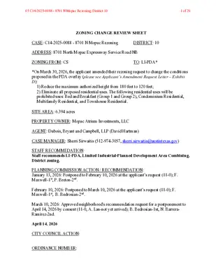
ZONING CHANGE REVIEW SHEET CASE: C14-2025-0088 - 8701 N Mopac Rezoning DISTRICT: 10 ADDRESS: 8701 North Mopac Expressway Service Road NB ZONING FROM: CS TO: LI-PDA* *On March 30, 2026, the applicant amended their rezoning request to change the conditions proposed in the PDA overlay (please see Applicant’s Amendment Request Letter – Exhibit D): 1) Reduce the maximum authorized height from 180 feet to 120 feet; 2) Eliminate all proposed residential uses. The following residential uses will be prohibited uses: Bed and Breakfast (Group 1 and Group 2), Condominium Residential, Multifamily Residential, and Townhouse Residential. SITE AREA: 6.394 acres PROPERTY OWNER: Mopac Atrium Investments, LLC AGENT: Dubois, Bryant and Campbell, LLP (David Hartman) CASE MANAGER: Sherri Sirwaitis (512-974-3057, sherri.sirwaitis@austintexas.gov) STAFF RECOMMEDATION: Staff recommends LI-PDA, Limited Industrial-Planned Development Area Combining, District zoning. PLANNING COMMISSION ACTION / RECOMMENDATION: January 13, 2026: Postponed to February 10, 2026 at the applicant’s request (11-0); F. Maxwell-1st, P. Breton-2nd. February 10, 2026: Postponed to March 10, 2026 at the applicant’s request (11-0); F. Maxwell-1st, B. Bedrosian-2nd. March 10, 2026: Approved neighborhood's recommendation request for a postponement to April 14, 2026 by consent (11-0, A. Lan-not yet arrived); B. Bedrosian-1st, N. Barrera- Ramirez-2nd. April 14, 2026 CITY COUNCIL ACTION: ORDINANCE NUMBER: 05 C14-2025-0088 - 8701 N Mopac Rezoning; District 101 of 20 C14-2025-0088 ISSUES: 2 During the Burnet Road, Anderson Lane and the North Shoal Creek Area neighborhood planning process, the long-range planning staff did not add the –NP combining district to the end of the zoning string for the properties in the planning area. Therefore, the rezoning request does not require the “NP” annotation. The North Shoal Creek Neighborhood Plan designates this property as “Commerce”. Therefore, the applicant has submitted an associated NPA application, case NPA-2025- 0031.01, requesting a Future Land Use Map (FLUM) change to “Mixed-Use Activity Corridor.” CASE MANAGER COMMENTS: The property in question is developed with office buildings (The Atrium Office Centre and Chancellor Center) fronting the northbound service road for the MoPac Expressway. There is an industrial use/emulsion plant (Ergon Asphalt & Emulsions, Inc.) and a landscaping supply use (Legacy Turf and Greens) to the north. The lots to the south are developed with an office complex. To the east, there is a railway and office and industrial uses along Shoal Creek Boulevard. To the west is the North Mopac Expressway (Loop 1). This property was recently rezoned from LO and LR zoning to CS zoning in 2022 through zoning case C14-2022-0087 to bring the existing office development into conformance with land use regulations in the Code (please see Area Case Histories below). The applicant is requesting LI-PDA, Limited Industrial-Planned Development Area District, zoning with a maximum height of 120 feet and 3:1 FAR to redevelop the property with a commercial project at this location (please see Applicant’s Request Letter-Exhibit C and Applicant’s Amendment Request Letter-Exhibit D). The proposed PDA Conditions are as follows: The applicant is requesting the following changes to the LI base district through the PDA overlay: 1) Additional Permitted Uses by right: Hospital services (Limited) Private Primary Educational Facilities Private Secondary Educational Facilities Public Primary Educational Facilities Public Secondary Educational Facilities 2) Conditional Uses: Hospital Services (General) 3) Prohibited Uses as principal uses on the property: Monument retail sales Scrap and salvage Basic industry General warehousing and distribution Light manufacturing Recycling center 05 C14-2025-0088 - 8701 N Mopac Rezoning; District 102 of 20 3 C14-2025-0088 Resource extraction 4) The following modifications to the LI base district site development regulations: Maximum Height: FAR: Impervious Coverage: Building Coverage: Setbacks: 180’ 120’ 3:1 95% 95% a) Front yard: 0’ b) Street side yard: 0’ c) Interior side yard: 0’ d) Rear yard setback: 0’ e) There are no minimum site area requirements for residential uses. The staff recommends the applicant’s amended request for LI-PDA zoning for this property because the language in the North Shoal Creek Neighborhood Plan supports more intensive commercial uses along the frontage of the MoPac Expressway. In addition, the site under consideration is adjacent to an asphalt/emulsion plant to the north and backs up to the railroad tracks to the east. The proposed zoning is consistent with the zoning and land use patterns in this area as there is commercial (CS) zoning to the north and south and office and industrial uses (zoned LI, LI-PDA) across the rail line to the east of this site. The property is located within the North Burnet/Gateway Station Regional Center as designated by the Imagine Austin Comprehensive Plan. However, it is not within the North Burnet/Gateway Neighborhood Plan or Regulating Plan as it is separated from the NBG by U.S. Highway 183. The applicant agrees with the staff ‘s recommendation. BASIS OF RECOMMENDATION: 1. The proposed zoning is not consistent with the purpose statement of the district sought. Limited industrial service (LI) district is the designation for a commercial service use or limited manufacturing use generally located on a moderately-sized site. The purpose of a planned development area (PDA) combining district is to: (1) provide for industrial and commercial uses in certain commercial and industrial base districts; or (2) incorporate the terms of a planned development area agreement into a zoning ordinance following annexation of a property that is subject to a planned development area agreement. 05 C14-2025-0088 - 8701 N Mopac Rezoning; District 103 of 20 C14-2025-0088 4 2. The proposed zoning should promote consistency and orderly planning. The proposed LI-PDA zoning would be compatible with existing zoning patterns in this area because there is LI and LI-PDA zoning to the east and CS zoning to the north and to the south. The proposed CS zoning is consistent with the Commerce character district designation adopted for this area in the North Shoal Creek Neighborhood Plan. 3. The proposed zoning should allow for a reasonable use of the property. Limited Industrial-Planned Development Area zoning would allow for a fair and reasonable use of the site because it would provide the applicant with additional height, FAR and permitted uses to allow for the expansion of office and commercial services on a site that fronts onto a major arterial Level 4 roadway/highway. The property is located within the North Burnet/Gateway Station Regional Center as designated by the Imagine Austin Comprehensive Plan. EXISTING ZONING AND LAND USES: ZONING CS Site North CS South CS, GR, GR-CO East LI, LI-PDA West ROW, GR LAND USES Office (The Atrium Office Centre, Chancellor Center) Industrial (Ergon Asphalt & Emulsions, Inc.) Office (Mopac Centre), Automotive Services (NTB) Railway (Union Pacific Railroad), Office/Warehouse, Office (TDCJ Government Building), Industrial (All-Tex, Facets of Austin) MoPac Expressway, Office (Hydridge Place) NEIGHBORHOOD PLANNING AREA: Burnet Road, Anderson Lane and the North Shoal Creek Neighborhood Planning Area WATERSHED: Shoal Creek SCHOOLS: Austin I.S.D. Pillow Elementary Burnet Middle School Anderson Hill School NEIGHBORHOOD ORGANIZATIONS: Austin Independent School District, Austin Neighborhoods Council, Friends of Austin Neighborhoods, Homeless Neighborhood Association, 05 C14-2025-0088 - 8701 N Mopac Rezoning; District 104 of 20 C14-2025-0088 5 NW Austin Neighbors, North Austin Neighborhood Alliance, North Shoal Creek Neighborhood Assn., North Shoal Creek Neighborhood Plan Contact Team, Shoal Creek Conservancy, TNR BCP - Travis County Natural Resources AREA CASE HISTORIES: NUMBER C14-2022-0117 (8640 and 8700 Shoal Creek Blvd.) REQUEST LI to LI-PDA COMMISSION 2/28/2023: Approved staff's recommendation of LI-PDA zoning (11-0, Y. Flores-absent); J. Mushtaler-1st, J. Shieh-2nd. C14-2022-0087 (8701 and 8627 N MoPac) LO and LR to CS C14-2020-0013 (8803 N Mopac) LI to CS 9/13/22: Approved staff's recommendation of CS zoning by consent (8-0, J. Mushtaler- arrived late, G. Anderson, Y. Flores and J. Shieh-absent); C. Hempel-1st, J. Thompson- 2nd. 5/12/20: Approved staff's recommendation of CS zoning by consent (13-0); P. Seeger-1st, G. Anderson-2nd. C14-2014-0156 (MoPac Rezoning: 8611 LO to GR 11/12/14: Approved staff rec. of GR-CO zoning on consent (8-0, L. Varghese-absent); R. Hatfield- 1st, B. Roark-2nd. C14-2010-0164 (8610 North Mopac Rezoning) LR-CO to GR 11/16/10: Approved GR-CO zoning on consent, with the following additional conditions offered by the applicant: No Pawn Shop Services use and a public restrictive covenant to state that business will be closed CITY COUNCIL 4/13/2023: The public hearing was conducted and a motion to close the public hearing and approve Ordinance No. 20230413-066 for LI-PDA combining district zoning was approved on Council Member Alison Alter's motion, Council Member Harper- Madison's second without objection. 10/13/22: Approved staff's recommendation of CS zoning by consent (9-0 vote, N. Harper- Madison and V. Fuentes - off the dais). 6/11/20: Approved CS district zoning, with additional condition agreed to by the neighborhood and the applicant is to prohibit Adult Oriented Businesses (11-0); all 3 readings 11/ 20/14: Approved GR-CO zoning, with additional conditions agreed to by the applicant and the neighborhood, on consent on all 3 readings (7-0) 12/11/14: Approved GR-CO zoning on consent on 2nd/3rd readings (7-0) 12/09/10: Approved GR-CO zoning on consent on all 3 readings (7-0); B. Spelman-1st, M. Martinez-2nd. 05 C14-2025-0088 - 8701 N Mopac Rezoning; District 105 of 20 C14-2025-0088 6 CS to CS-MU during the hours of 10:00 p.m. to 6:00 a.m. (6-0, Banks-absent); P. Seeger-1st, D. Tiemann-2nd. 7/30/07: Approved staff rec. for CS-MU-CO with conditions (8-0) SF-3 to LO and LR 4/02/91: Denied LR-CO & LO- CO zoning C14-2007-0085 (8888 Tallwood Drive) C14-91-0013 (Horizon Savings Motorbank) 8/09/07: Approved CS-MU-CO zoning, with CO to prohibit Adult Oriented Businesses and a 2,000 vehicle trip limit per day 5/23/91: Approved LR-CO for Tract 1 and LO-CO zoning for Tract 2 w/ following conditions: 1) prohibit Food Sales, General Retail Sales (Convenience), Restaurant (Limited), Restaurant (Drive-In/Fast Food), and Service Station uses on Tract 1; 2) No vehicular access from Tract 2 to Camelia Lane; 3) Maintain the existing 40 ft vegetative buffer along the western property line of Tract 2; 4) Maintain a 25 ft vegetative buffer along the northern property line of Tract 2; 5) Structures on Tract 2 shall not exceed two stories or 35 ft in height RELATED CASES: NPA-2025-0031.01 - Neighborhood Plan Amendment C14-2022-0087 – Previous Zoning Case OTHER STAFF COMMENTS: Environmental The site is not located over the Edwards Aquifer Recharge Zone. The site is located in the Shoal Creek Watershed of the Colorado River Basin, which is classified as an Urban Watershed by Chapter 25-8 of the City's Land Development Code. It is in the Desired Development Zone. Zoning district impervious cover limits apply in the Urban Watershed classification. According to floodplain maps there is no floodplain within or adjacent to the project location. Standard landscaping and tree protection will be required in accordance with LDC 25-2 and 25-8 for all development and/or redevelopment. 05 C14-2025-0088 - 8701 N Mopac Rezoning; District 106 of 20 C14-2025-0088 7 At this time, site specific information is unavailable regarding vegetation, areas of steep slope, or other environmental features such as bluffs, springs, canyon rimrock, caves, sinkholes, and wetlands. This site is required to provide on-site water quality controls (or payment in lieu of) for all development and/or redevelopment when 8,000 sq. ft. cumulative is exceeded, andon-sitee control for the two-year storm. At this time, no information has been provided as to whether this property has any preexisting approvals that preempt current water quality or Code requirements. Fire A setback of 100 ft is required from the property line to the north based on the current chemical inventory on that site (please see Aboveground Hazardous Materials Consequence Analysis Report – Exhibit F). Please note that this setback only applies to “Multifamily Residential” development. AFD does not require a setback if no residential zoning/use is proposed. Parks and Recreation Parkland dedication will be required for the new applicable uses proposed by this development, multifamily with LI-PDA zoning, at the time of subdivision or site plan, per City Code § 25-1-601. Whether the requirement shall be met with fees in-lieu or dedicated land will be determined using the criteria in City Code Title 25, Article 14, as amended. Should any fees in-lieu be required, those fees shall be used toward park investments in the form of land acquisition and/or park amenities within the surrounding area, per the Parkland Dedication Operating Procedures § 14.3.11 and City Code § 25-1-609. If the applicant wishes to discuss parkland dedication requirements in advance of site plan or subdivision applications, please contact this reviewer: ann.desanctis@austintexas.gov. At the applicant’s request, PARD can provide an early determination of whether fees in-lieu of land will be allowed. Site Plan Site plans will be required for any new development except for residential only project with up to 4 units. Any new development is subject to Subchapter E. Design Standards and Mixed Use. Additional comments will be made when the site plan is submitted. 05 C14-2025-0088 - 8701 N Mopac Rezoning; District 107 of 20 C14-2025-0088 Transportation 8 The adjacent street characteristics table is provided below: Name ASMP Classification ASMP Required ROW Existing ROW Existing Pavement Sidewalks Bicycle Route Capital Metro (within ¼ mile) N. Mopac SR Level 4 N/A TxDOT Road TxDOT Road TxDOT Road Yes No No Water Utility No comments on zoning change. FYI: The landowner intends to serve the site with existing City of Austin water utilities. Based on current public infrastructure configurations, it appears that service extension requests (SER) will be required to provide service to this lot. For more information pertaining to the Service Extension Request process and submittal requirements contact the Austin Water SER team at ser@austintexas.gov. INDEX OF EXHIBITS TO FOLLOW A: Zoning Map B. Aerial Map C. North Shoal Creek NP FLUM D. Applicant’s Request Letter E. Applicant’s Amendment Request Letter F. AFD Aboveground Hazardous Materials Consequence Analysis Report G. Comments Received 05 C14-2025-0088 - 8701 N Mopac Rezoning; District 108 of 20 EXHIBIT A !!!!!!!!!!!!!!!!!!!!!!!!!!!!!!!!!!!!!!!!!!!!!!!!!!!!!!!!!!!!!!!!!!!!!!!!!!!!!!!!!!!!!!!!!!!!!!!!!!!!!!!!!!!!!!!!!!!!!!!!!!(!(!(!(!(!(!(!(!(!(!(!(!(!(!(!(!(!(!(!(!(!(!(!(!(!(!(!(!(!(!(!(!(!(!(!(!(!(!(!(!(!(!(!(!(!(!(!(!(!(!(!(!(!(!(!(!(!(!(!(!(!(!(!(!(!(!(!(!(!(!(!(!(!(!(!(!(!(!(!(!(!(!(!(!(!(!(!(!(!(!(!(!(!(!(!(!(!(!(!(!(!(!(!(!(!(!(!(!(!(!(!(!(!(!(!(!(!(!(!(!(!(!(!(!(!(!(!(!(!(!(!(!(!(!(!(!(!(!(!(!(!(!(!(!(!(!(!(!(!(!(!(!(!(!(!(!(!(!(!(!(!(!(!(!(!(!(!(!(!(!=!=!=!=!=!=!=!>!>!>!>!>!>!>C14-2022-0087C14R-82-016(RCT)C14-2008-0182C14-2020-0013C14-2022-0117NP-2016-0031NPA-2020-0031.01NPA-2022-0031.01C14R-87-131C14-2014-0156C14-2010-0164C14H-2021-0165C14-2014-0192C14-2015-0056NMOPACEXPYSBNMOPACEXPYNBNMOPACEXPYSVRDNBNMOPACEXPYSVRDSBMILLWAYDRSHOALCREEKBLVDHYRIDGEDRRESEARCHBLVDSBTALLWOODDRCAMELIALNRESEARCHBLVDNBAZALEATRLWILLOWICKDRCROSSCREEKDRCIMASERENADAWNRIDGECIRBUSINESSPARKDRRESEARCHBLVDSVRDSBRESEARCHTONMOPACSBRAMPRESEARCHNBTOMOPACRAMPCLABURNDRNMOPACSBTOSTECKRAMPNMOPACNBTORESEARCHRAMPUNITEDTORESEARCHNBRAMPRESEARCHBLVDSVRDNBMOPACSBTORESEARCHSBRAMPMOPACNBTORESEARCHNBRAMPHONEYSUCKLETRLNMOPACSTECKBYPASSRAMPBENBROOKDRDALEVIEWDRSERENAWOODSCTLILILICSCSSF-3LOCSLOSF-3MF-2GRCSSF-3SF-2SF-3SF-2SF-3SF-2P-NPSF-2SF-3NBG-NPMF-3MF-3LI-PDAMF-2GRGR-MU-V-CO-DB90LISF-2SF-2SF-3SF-3LOCS-MU-COSF-2PUDSF-3GRSF-3SF-3GR-COLO-COGR-COPUDSF-3PUDSF-2LOLOSF-3-HGR-COCSSF-3LO84-14778-11472-2678-2479-7375-6583-3688-00578-22266-13175-09275-10777-10575-232SP-85-014R84-110P83-36R82-47R87-131SP-03-0407CSP-01-0490CSP-95-0157CSP-02-0140CSPC-88-0189ACP78-63REST.C14R-82-016RCAPTS.OFFICE BLDG.R83-62RCSUPPLY CO.RADIAN CORP.OFFICE PARKBLDG.OFFICEBLDGS.AIR CONTROLPLANTEMULSIONPLUMBINGTEXASPARKVACANTWAREHOUSE PARKCOMMERCIALBOARD85-2442007-0085COMMERCIALAPTS.APTS.PARK84-147OFFICEAPTS.APTS.APTS.OFFICE78-222APTS.OFFICEVACANTZONING±This product is for informational purposes and may not have been prepared for or be suitable for legal,engineering, or surveying purposes. It does not represent an on-the-ground survey and represents only theapproximate relative location of property boundaries.This product has been produced by the Planning Department for the sole purpose of geographic reference.No warranty is made by the City of Austin regarding specific accuracy or completeness.ZONING CASE#:C14-2025-0088SUBJECT TRACT!!!!!!PENDING CASEZONING BOUNDARYCreated: 8/20/20250400200Feet05 C14-2025-0088 - 8701 N Mopac Rezoning; District 109 of 20 EXHIBIT B !!!!!!!!!!!!!!!!!!!!!!!!!!!!!!!!!!!!!!!!!!!!!!!!!!!!!!!!!!!!!!!!!!!!!!!!!!!!!!!!!!!!!!!!!!!!!!!!!!!!!!!!!!!!!!!!!!!!!!!!!(!(!(!(!(!(!(!(!(!(!(!(!(!(!(!(!(!(!(!(!(!(!(!(!(!(!(!(!(!(!(!(!(!(!(!(!(!(!(!(!(!(!(!(!(!(!(!(!(!(!(!(!(!(!(!(!(!(!(!(!(!(!(!(!(!(!(!(!(!(!(!(!(!(!(!(!(!(!(!(!(!(!(!(!(!(!(!(!(!(!(!(!(!(!(!(!(!(!(!(!(!(!(!(!(!(!(!(!(!(!(!(!(!(!(!(!(!(!(!(!(!(!(!(!(!(!(!(!(!(!(!(!(!(!(!(!(!(!(!(!(!(!(!(!(!(!(!(!(!(!(!(!(!(!(!(!(!(!(!(!(!(!(!(!(!(!(!(!=!=!=!=!=!=!=!>!>!>!>!>!>C14-2025-0088C14-2022-0087C14R-82-016(RCT)C14-2008-0182C14-2020-0013C14-2022-0117NP-2016-0031NPA-2020-0031.01NPA-2022-0031.01C14R-87-131C14-2014-0156C14-2010-0164C14H-2021-0165C14-2014-0192C14-2015-0056NMOPACEXPYSBNMOPACEXPYNBNMOPACEXPYSVRDNBNMOPACEXPYSVRDSBMILLWAYDRSHOALCREEKBLVDHYRIDGEDRCAMELIALNRESEARCHBLVDSBTALLWOODDRRESEARCHBLVDNBAZALEATRLWILLOWICKDRCROSSCREEKDRCIMASERENADAWNRIDGECIRBUSINESSPARKDRMOSSROCKDRRESEARCHTONMOPACSBRAMPRESEARCHBLVDSVRDSBRESEARCHNBTOMOPACRAMPNMOPACSBTOSTECKRAMPNMOPACNBTORESEARCHRAMPCLABURNDRMOPACSBTORESEARCHSBRAMPUNITEDTORESEARCHNBRAMPMOPACNBTORESEARCHNBRAMPRESEARCHBLVDSVRDNBNMOPACSTECKBYPASSRAMPHONEYSUCKLETRLBENBROOKDRDALEVIEWDRSERENAWOODSCTLILILICSCSSF-3LOCSLOMF-2SF-3GRCSSF-3SF-2SF-3SF-2SF-3P-NPSF-2SF-2SF-3MF-3MF-3NBG-NPLI-PDAGRGR-MU-V-CO-DB90LIMF-2SF-2SF-2SF-3LOCS-MU-COSF-3SF-2PUDSF-3GRSF-3SF-3GR-COLO-COGR-COPUDSF-2PUDLOLOSF-3-HGR-COCSSF-38701 N Mopac Multifamily±This product has been produced by Planning Department for the sole purpose of geographic reference. No warranty ismade by the City of Austin regarding specific accuracy or completeness.ZONING CASE#:LOCATION:SUBJECT AREA:MANAGER:C14-2025-00888701 N Mopac Expy Svrd NB6.39 AcresSherri SirwaitisCreated: 9/18/2025SUBJECT TRACTZONING BOUNDARY!!!!!PENDING CASECREEK BUFFER1 inch equals 400 '05 C14-2025-0088 - 8701 N Mopac Rezoning; District 1010 of 20 I I B N D R V S Y R C N A T N U O M K A O R D North Shoal Creek Neighborhood Planning Area K TALLWOOD R A P Future Land Use Map DR S S E EXP IN TRL S U N E B L L IA K C L U E S M Y A E N C O H RESEARCHBLVDSVRDNB RESEARCH BLVD SB B Y S P X C E MOPAC A N P O N M R D D E NIT U D LV B E R T N R D K C O R S S O M L R A T E L A Z A R K D WIC CIMA SERENA WATERFORD CE R D EID O L WIL C L R R D R EIL N C M DAWNRIDGE CIR AIL D A G N N O D R N D N A C C M R E D HIR S L E M R D D O O W H S U R H T R A D R U A E L L T LIT WINDIN CROSSCREEK DR G W A L K N L E S O R RIM P D V L B K E E R C L A O H S R D Y A LW L I M R D W IE V E L A D R D E N O T S G A L F N D L O O W N A R F D R T E N R U B R D N E E R G G N I L W O B POLARIS AVE FIRWOOD DR VINEWOOD CV BOXDALE DR D LN N D L O O O O W W K E C VIN O R VALLEYDALE CV PENNYLN BUELL AVE V E C L A D K V R E C A P L A D E PIN ASHDALE DR DORIS DR OHLEN RD R D Y A W A H T A H N A L D E E R LANIER DR KENBRIDGEDR TEAKWOOD DR N D L O O W R RIA B N D L O O LW TIL S R D D O O W G LO R E D L A D K R PA STECK AVE D R ABURN BRANIGAN LN D E R E R T T N E B B S D R V S Y XP B E N C A P Y O P M N X E C A P O M WESTCHESTER AVE N E V A T E N N O S R D T S E R O F H T R O N B N D R V S Y XP E C A MOP N FOSTER LN WHITEPINEDR MCELROYDR WHITEWAYDR YELLOWPINE TER SILVERLEAFDR SKYLARK DR STARDUST DR GREENLAWN PKWY Adopted: 5/13/2004 Updated: 5/17/2023 City of Austin Housing and Planning Department NORTHERNBLVD T A E R G ORANGEWOOD CIR WANDERSONLN R D R O O XM E T S N A M K C O R Commerce B T S S E L A S Land Use Categories MAHONE AVE N O R THCROSSDR SPRUCELEAF CIR S Industry R Y D Mixed-use Activity Hub/Corridor D R A H Neighborhood Node BARBARA ST TJOSEPHBLVD A comprehensive plan shall not constitute zoning regulations or establish zoning district boundaries. Please see the Brentwood/Highland Neighborhood Plan document for more detailed description of the vision and future land use for areas within the neighborhood. This product is for informational purposes and may not have been prepared for or be suitable for legal, engineering, or surveying purposes. It does not represent an on-the-ground survey and represents only the approximate relative location of property boundaries. This product has been produced by the Housing and Planning Department for the sole purpose of geographic reference. No warranty is R D T S E R C R E SILVERWAY DR SILVERLEAF CIR CASCADEDR SILV RICHCREEK RD EXHIBIT C ¯ N S L R E D N U A S M E TRIC B L V D R D E D S E R F I I HEARTHSTONEDR HEARTHSIDEDR JOYLN W O O D S TO NE D R R N D R U B Y E W V E C N A R R E H N C T O O C N D R P U T N A M D R C V V E C L B KIM RICHWOOD DR KINGWOODCV PALMW EASTER RIPPLEWOOD DR OOTENDR POMPTONDR BELFORD DR W Neighborhood Transition O O D C V Recreation & Open Space Residential Core DALE DR WOOTENPARK E R Special District V N D S A R Permitted Special Uses D E R L L E Permitted Special Uses L L G U DUKE AVE E T M R Neighborhood Urban Center U R R U Mixed Use Building B D R 05 C14-2025-0088 - 8701 N Mopac Rezoning; District 1011 of 20 EXHIBIT D David Hartman (512) 685- 3409 dhartman@dbcllp.com 303 Colorado, Suite 2300 Austin, TX 78701 www.dbcllp.com August 11, 2025 Lauren Middleton-Pratt Director, Planning Department City of Austin 6310 Wilhelmina Delco Drive Austin, Texas 78752 Re: 8701 N Mopac Multifamily – Rezoning and Neighborhood Plan Applications for 6.39 acres located at 8701 N Mopac Expy SVRD NB, Austin, Texas 78759 (“Property”) Dear Ms. Middleton-Pratt: We respectfully submit the enclosed Zoning and Neighborhood Plan Amendment (“NPA”) applications for 8701 N Mopac Multifamily as representatives of the owners of the above stated Property. The Property covers 6.39 acres located at 8701 N Mopac Expy SVRD NB, Austin, Texas 78759. The Property is currently developed with office space and related parking and has direct access to the N. MoPac Expy Service Road. The current zoning of the Property is General Commercial Services (“CS”), and we are requesting Limited Industrial Services – Planned Development Area (“LI-PDA”) zoning with a maximum height of 180’ and 3:1 FAR for the entire Property to authorize development of a multifamily project. The proposed Planned Development Area development standards for the Property in connection with the zoning application are set forth on the attached Exhibit “A”. The Property is located near two Imagine Austin Centers - the North/Burnet Gateway Station Regional Center which is identified in the Imagine Austin Comprehensive Plan as Austin’s “second downtown,” and the Anderson Lane Station Neighborhood Center. The adjacent Loop 1/Mopac Expressway Toll Road and Research Boulevard are both ASMP Level 5 Streets. The Property has direct access to the N Mopac Expressway service road that provides access to N Mopac Expressway and also runs directly to Braker Lane and the North/Burnet Gateway area. The Property is located adjacent to multiple bus routes/stops, bike routes, and an urban trail network. Adjacent property is zoned CS and LI-PDA (maximum 75’ height). Additional adjacent zoning districts include NBG CMU- Midway (maximum 350’ height, 10:1 FAR), NBG-CMU (maximum 180’ height, 3:1 FAR), NBG-WMU (maximum 120’ height, 3:1 FAR) and LI-PDA (maximum 180’ height, 3:1 FAR). The Property is located within the North Shoal Creek Neighborhood Plan. The Future Land Use Map (“FLUM”) designates the Property as “Commerce,” therefore we have submitted a NPA application requesting that the FLUM designation be changed to “Mixed-Use Activity Corridor.” The TIA Determination Worksheet dated August 8, 2025, signed by Mustafa Wali, states that a Traffic Impact Analysis is not required. If you have any questions about the applications or need additional information, please do not hesitate to contact me at your convenience. Thank you for your time and attention to this project. Very truly yours, David Hartman 4258632.6 05 C14-2025-0088 - 8701 N Mopac Rezoning; District 1012 of 20 Exhibit “A” Proposed Planned Development Area Development Standards for 8701 N Mopac Multifamily The Proposed Planned Development Area standards for the Property in connection with the zoning application are as follows: A. Uses. All permitted, conditional, and prohibited uses under LI zoning are permitted, conditional, and prohibited uses for the LI-PDA zoning for the subject tract with the following modifications in Section A(1) through A(3) below. 1. Permitted Uses. The following uses are additional permitted uses: a) Bed and breakfast residential (Group 1) b) Bed and breakfast residential (Group 2) c) Condominium residential d) Multifamily residential e) Townhouse residential f) Hospital services (Limited) g) Private Primary Educational Facilities h) Private Secondary Educational Facilities i) Public Primary Educational Facilities j) Public Secondary Educational Facilities 2. Conditional Uses. The following use is an additional conditional use: a) Hospital Services (General) 3. Prohibited Uses. The following uses are prohibited as principal uses: a) Monument retail sales b) Scrap and salvage c) Basic industry d) General warehousing and distribution e) Light manufacturing f) Recycling center g) Resource extraction B. Site Development Standards. LI site development standards apply to the LI-PDA zoning for the subject tract, with the following modifications in Section B(1)-B(6) below. 1. Maximum Height: 2. FAR: 3. 4. Building Coverage: 5. Setbacks: 180’ 3:1 95% 95% Impervious Coverage: a) Front yard: b) Street side yard: c) Interior side yard: d) Rear yard setback: 0’ 0’ 0’ 0’ 6. There are no minimum site area requirements for residential uses. 4258632.6 05 C14-2025-0088 - 8701 N Mopac Rezoning; District 1013 of 20 EXHIBIT E David Hartman (512) 685-3409 303 Colorado, Suite 2300 Austin, TX 78701 dhartman@dbcllp.com March 30, 2026 Lauren Middleton-Pratt Director, Planning Department City of Austin 6310 Wilhelmina Delco Drive Austin, Texas 78752 Re: 8701 N Mopac Rezoning – Applicant Amendment Letter to the Rezoning Application (case #C14- 2025-0088) for 6.39 acres located at 8701 N Mopac Expy SVRD NB, Austin, Texas 78759 (“Property”) Dear Ms. Middleton-Pratt: We respectfully submit this letter to amend the zoning application currently under review (assigned case C14-2025-0088) for the project initially titled “8701 N Mopac Multifamily” for which the initial zoning application was submitted on August 19, 2025, as representatives of the owners of the above stated Property. The initial zoning application for the Property that was initially submitted seeks to in part to authorize the following on the Property: 1) a maximum height of 180 feet, and 2) multiple residential uses. This amendment requests the following on the Property for the zoning case: a) Reduce the maximum authorized height from 180 feet to 120 feet; b) Eliminate all proposed residential uses. Specifically, the following residential uses will be prohibited uses: Bed and Breakfast (Group 1 and Group 2), Condominium Residential, Multifamily Residential, and Townhouse Residential; and c) Revise the zoning case/project name for zoning case #C14-2025-0088 from “8701 N Mopac Multifamily” to “8701 N. Mopac Rezoning”. The proposed Planned Development Area development standards for the Property in connection with this amended zoning application are set forth on the attached Exhibit “A”. An updated TIA Determination worksheet dated March 30, 2026 and signed by Mustafa Wali, states that a Traffic Impact Analysis is not required. If you have any questions about the zoning application amendment or need additional information, please do not hesitate to contact me at your convenience. Thank you for your time and attention to this project. Very truly yours, David Hartman 6073714.1 05 C14-2025-0088 - 8701 N Mopac Rezoning; District 1014 of 20 Exhibit “A” Applicant Amendment Letter Amended Proposed Planned Development Area Development Standards for 8701 N Mopac Multifamily The Proposed Planned Development Area standards for the Property in connection with the zoning application are as follows: A. Uses. All permitted, conditional, and prohibited uses under LI zoning are permitted, conditional, and prohibited uses for the LI-PDA zoning for the subject tract with the following modifications in Section A(1) through A(3) below. 1. Permitted Uses. The following uses are additional permitted uses: a) Hospital services (Limited) b) Private Primary Educational Facilities c) Private Secondary Educational Facilities d) Public Primary Educational Facilities e) Public Secondary Educational Facilities 2. Conditional Uses. The following use is an additional conditional use: a) Hospital Services (General) 3. Prohibited Uses. The following uses are prohibited as principal uses: a) Monument retail sales b) Scrap and salvage c) Basic industry d) General warehousing and distribution e) Light manufacturing f) Recycling center g) Resource extraction B. Site Development Standards. LI site development standards apply to the LI-PDA zoning for the subject tract, with the following modifications in Section B(1)-B(6) below. 1. Maximum Height: 2. FAR: 3. 4. Building Coverage: 5. Setbacks: 120’ 3:1 95% 95% Impervious Coverage: a) Front yard: b) Street side yard: c) Interior side yard: d) Rear yard setback: 0’ 0’ 0’ 0’ 6. There are no minimum site area requirements for residential uses. 6073714.1 05 C14-2025-0088 - 8701 N Mopac Rezoning; District 1015 of 20 EXHIBIT F ABOVEGROUND HAZARDOUS MATERIALS CONSEQUENCE ANALYSIS REPORT Case Number: N/A Informal Address: 8701 N Mopac Expy Report Date: April 28, 2025 Project Name: 8701 N Mopac Expy Prepared By: Yvonne Espinoza, Consulting Engineer, Hazardous Materials Contact Information: 512-974-0185 yvonne.espinoza@austintexas.gov Case Manager Current Zoning Proposed Zoning Parcel Size N/A CS Multifamily Residential 6.39 Acres Project Information Adjacent Zoning/Property Information 05 C14-2025-0088 - 8701 N Mopac Rezoning; District 1016 of 20 ABOVEGROUND HAZARDOUS MATERIALS CONSEQUENCE ANALYSIS REPORT Case Number: N/A Informal Address: 8701 N Mopac Expy Report Date: April 28, 2025 Project Name: 8701 N Mopac Expy Prepared By: Yvonne Espinoza, Consulting Engineer, Hazardous Materials Contact Information: 512-974-0185 yvonne.espinoza@austintexas.gov Address Range(s) Street Address Range(s) Street Address Ranges within 1000 Ft. 8500 -8905 3501 -3601 9200-9237 Business N Mopac Expy NB Hyridge Dr Research Blvd 8512 - 8750 8871 - 8888 Shoal Creek Blvd Tallwood Dr HMP Sites within 1000 Ft. Address Zoning Signature Science Texas Children’s Hospital Ergon Asphalt Urology Austin Lab Shoal Creek HP, LTD 8501 N Mopac Expy 8611 N Mopac Expy 8803 N Mopac Expy 8701 N Mopac Expy 8610 Shoal Creek Blvd LI GR CS CS LI HMP Type A A A B C Last Insp. Concern? 7/2024 5/2022 4/2015 9/2024 Unknown N N Y N N Business Chemicals Distance to Property AFD Required Distance for Chemical ERG Required Distance for Chemical Meeting Distance Requirement? Ergon Asphalt 14,000 Gallons of Caustic Soda Solution 10,500 Gallons of Oil Emulsion 19,000 Gallons of Fuel Oil 0 ft 0 ft 0 ft 150 ft. 150 ft. 150 ft. No No No 05 C14-2025-0088 - 8701 N Mopac Rezoning; District 1017 of 20 ABOVEGROUND HAZARDOUS MATERIALS CONSEQUENCE ANALYSIS REPORT Case Number: N/A Informal Address: 8701 N Mopac Expy Report Date: April 28, 2025 Project Name: 8701 N Mopac Expy Prepared By: Yvonne Espinoza, Consulting Engineer, Hazardous Materials Contact Information: 512-974-0185 yvonne.espinoza@austintexas.gov Distance to Sites Identified as Concerns Recommend to Allow Zoning Change? Yes with conditions No Supporting Information for Zoning Decision AFD would recommend to Planning that the zoning change be approved with a setback of 100 ft from the property line to the north based on the current chemical inventory on that site. HMP Inventories Prepared by FD1666 August 1, 2019 Attachments 05 C14-2025-0088 - 8701 N Mopac Rezoning; District 1018 of 20 EXHIBIT G From: North Shoal Creek Neighborhood PIan Contact Team Date: April 6,2026 To: City of Austin Housing & Planning Department Planning Commission Re: Recommendation on Plan Amendment Case #NPA-2025-0031.01 and Zoning Case # Cl4-2025-0088, located at 8701 N Mopac Expy SVRD NS The North Shoal Creek Neighborhood Plan Contact Team met in person on April 6,2026 to consider Plan Amendment Case #NPA-2025-0031.01 along with associatedZoning Case #C14- 2025-0088, as amended by applicant in a letter to .Austin Planning Department dated March th, 2026. Both r;ases are associated with the property located at 8701 N Mopac Service Road. As allowed per our bylaws, team members discussed and voted on the question of supporting or opposing the following two items: 1) To change the future land use map (FLUM) from Commerce to Mixed-Use Activity HUB/Corridor; and 2) To change the zoning from CS (General Commercial Services) to LI-PDA (Limited Indu strial District-Planned Development Area). The Contact Team's primary concern with the original application was the inclusion of residential uses for this properfy. In meetings with applicant's counsel, we raised the following issues related to residential uses: a a a a a o a a Ttre site is realistically only accessible by vehicle. There is only access into and out of the property from the northbound Mopac service road, and entry to the on-ramp to 183 is extremely risky. Concern about emergency vehicle access. There is inadequate public transportation. This site is isolated from the Norlh Shoal Creek residential core by the railroad tracks. There is no saf'e connection for pedestrians/cyclists to any of the existing neighborhoods. No contiguous access to Filkrw Elementary for student transport. Adjacent property on the north side is a cornmercial industrial facility (Ergon Asphalt and Emulsions), which is not safe for residents. The applicant's anrendrnent letter dated IVIarch 30,2026 eliminates all residential uses and limits building height to l2A ft.. in light of that update, the Contact Team voted 8 to 0 to support the amenried application to change ttre future land use nrap from Commerce to Mixed Use Activity Corridor and to change the zoning from CS to LI-PDA. The North Shoal Creek Neighborhood Plan Contact Team does not support the 95% impervious and building cover proposed in Exhibit "A" of the applicant's amendment letter and requests that the Planning Cornrriission limit impervious and ouilding cover for this property to 80% due to the proximity to Shoal Creek's headwaters. Greater water quality and quantity treatment is important lbr preventing flooding and pollution into Shoal Creek. The site also includes heritage trees which should be preserved and protected. 05 C14-2025-0088 - 8701 N Mopac Rezoning; District 1019 of 20 As stewards of the North Shoal Creek Neighborhood Plan, we appreciate this opportunity to engage with City staffin the proeess of reviewing these applications for zoning change and FLUM amendment, We support the proposed artrended zoning and FLUM changes,. with the changes to the Site Development Standards requested above. Sincerely, fu*ca/ Amelia Cobb Chair North Shoal Creek Neighborhood Plan Contact'feam slf ,hq? b bg!,$Seil$r.l rrt 512-364-55t9 :!,. 05 C14-2025-0088 - 8701 N Mopac Rezoning; District 1020 of 20