08 C14-2026-0017 - 55 N I-35; District 3 - Staff Report — original pdf
Backup
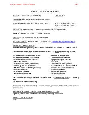
ZONING CHANGE REVIEW SHEET CASE: C14-2026-0017 (55 North I-35) DISTRICT: 3 ADDRESS: 55 N IH 35 Service Road North Bound ZONING FROM: LO-MU-CO-NP (Tracts 1 and 2) TO: CS-MU-CO-NP (Tract 1) and LO-MU-CO-NP (Tract 2) SITE AREA: approximately 1.16 acres (approximately 50,530 square feet) PROPERTY OWNER: HI 55, LLC (Nick Tarantino) AGENT: Weiss Architecture Inc. (Richard Weiss) CASE MANAGER: Jonathan Tomko (512) 974-1057, jonathan.tomko@austintexas.gov STAFF RECOMMEDATION: Staff recommends granting CS-MU-CO-NP on tract 1 and LO-MU-CO-NP on tract 2. The conditional overlay would be modified on tract 1 to allow the following 20 uses: - Administrative and business offices - Communications service facilities - Consumer convenience services - Financial services - General retail sales (convenience) - Indoor sports and recreation - Medical offices (> 5,000 square feet) - Personal services - Restaurant (limited) - Software development - Business or trade school - Communications services - Equipment repair services - Food sales - General retail sales (general) - Medical offices (< 5,000 square feet) - Personal improvement services - Professional office - Restaurant (general) - Veterinary services The conditional overlay would be modified on tract 1 to conditionally allow the following use: - Commercial off-street parking For a summary of the basis of Staff’s recommendation, please see the basis of recommendation section below. PLANNING COMMISSION ACTION / RECOMMENDATION: April 14, 2026: Case is scheduled to be heard by Planning Commission CITY COUNCIL ACTION: TBD 08 C14-2026-0017 - 55 N I-35; District 31 of 12 ORDINANCE NUMBER: TBD ISSUES: As noted in the applicant’s summary letter (see Exhibit C) staff did find evidence that there may have been a mapping error when the subject tract was last zoned, circa 2000. The CS base district zoning most likely should have been closer to I-35 to the west, descending in intensity to LO base district zoning to the east. However, it appears the less intense LO base district zoning was mapped closer to I-35 and the CS base district zoning to the east. While the question to rezone 1104 and 1106 Lambie Street is not currently on the table, granting this rezoning request would restore this property to appropriately transition, more intense zoning closer to the freeway and less intense to the east, further away from I-35. CASE MANAGER COMMENTS: The property in question is currently a vacant two-story medium-sized office building with a large surface parking lot. It is located at the northeast corner of the IH-35 service road northbound and Lambie Street. The service road is an ASMP level 4 and there is one driveway fronting the service road and two on Lambie Street which is an ASMP level 1. There are a number of vacant lots surrounding the subject tract, more than typically seen in the neighborhood to the east. Redevelopment of the subject tract may result in positive redevelopment on these lots. The building as it stands serves as a buffer between the neighborhood to the east and the busy interstate freeway to the west. The subject tract is approximately 200 feet from the Downtown Imagine Austin Activity Center across I-35 to the west, and approximately ¼ mile from East Cesar Chavez Street, which is an Imagine Austin Activity Corridor. The subject tract is also approximately 1,000 feet from the 17-acre RBJ Center which has over 1,000 multifamily residential units across eight buildings. BASIS OF RECOMMENDATION: Zoning should allow for reasonable use of the property The subject tract is located along a major interstate highway just outside of the central business district. Within this context the uses and zoning being requested promote a reasonable use of this underutilized property. The proposed zoning should be consistent with the goals and objectives of the City Council. Granting this rezoning request would help implement the goals of Imagine Austin by allowing more land uses proximate to the Downtown Imagine Austin Activity Center and East Cesar Chavez Street Imagine Austin Activity Corridor. EXISTING ZONING AND LAND USES: Site ZONING LO-MU-CO-NP LAND USES A two-story medium office building of approximately 25,000 square feet constructed in approximately 1971 with approximately 40,000 square feet of paved parking lot. 08 C14-2026-0017 - 55 N I-35; District 32 of 12 North (across alley) GR-MU-CO-NP and Four single family homes, and four vacant lots South (across Lambie Street) East West (across I-35) SF-3-NP GR-MU-CO-NP and SF-3-NP CS-MU-CO-NP P and CBD A fourplex, a triplex, a single-family home, and a vacant lot One single family home A power substation and surface parking lot NEIGHBORHOOD PLANNING AREA: East Cesar Chavez Neighborhood Planning Area WATERSHED: Lady Bird Lake Watershed SCHOOLS: A.I.S.D. Sanchez Elementary School Martin Middle School Austin High School COMMUNITY REGISTRY LIST: Austin Independent School District, Austin Neighborhoods Council, Del Valle Community Coalition, East Austin Conservancy, East Cesar Chavez Neighborhood Association, East Cesar Chavez Neighborhood Plan Contact Team, East Town Lake Citizens Neighborhood Association, El Concilio Mexican-American Neighborhoods, Friends of Austin Neighborhoods, Guadalupe Neighborhood Development Corporation, Homeless Neighborhood Association, Overton Family Committee, Preservation Austin, Tejano Town, Waterloo Greenway AREA CASE HISTORIES: Number C14-2019-0101 (East Cesar Chavez Vertical Mixed Use Building (V) Opt- In/Opt-Out Process) Request Rezoning property to show Vertical Mixed Use (VMU) Zoning on 7 tracts totaling 2.52 acres. 07.28.2009: Recommended on a vote of 8-0, Commissioner Dave Sullivan was absent. Commission City Council 08.06.2009: Recommended with motion sheet. Ten percent of rental units shall be reserved at or below 60% MFI. 06.06.2019: Recommended with 19 prohibited uses and 3 conditional uses. C14-2019-0072 (Rebeka Baines Johnson (RBJ) Center Communications Services Amendment) The Applicant is proposing to rezone 17.2167 acres from CS-MU-V-CO-NP to CS-MU-V-CO- NP, to allow Communications Services as a permitted land use. 05.14.2019: To grant CS-MU-V-CO-NP, to change a condition of zoning, as recommended by Staff, on consent. (13-0) [J. Shieh- 1 st, C. Kenny- 2 nd] RELATED CASES: None 08 C14-2026-0017 - 55 N I-35; District 33 of 12 ADDITIONAL STAFF COMMENTS: Comprehensive Planning Project Name and Proposed Use: 55 N IH 35 SERVICE ROAD NB. C14-2026-0017. Project: 55 N- IH35. 1.16 acres from LO-MU-CO-NP (Tracts 1 and 2) to CS-MU-CO-NP (Tract 1); LO-MU-CO-NP (Tract 2). Existing: general office building and parking lot. Proposed: general office building, health/fitness club, and parking lot. Proposing corrections to previously mislabeled base zoning districts, and the removal of use restrictions. Yes Imagine Austin Decision Guidelines Complete Community Measures * Y Y Y Y Y Y Y Y Imagine Austin Growth Concept Map: Located within or adjacent to an Imagine Austin Activity Center, Imagine Austin Activity Corridor, or Imagine Austin Job Center as identified the Growth Concept Map. Names of Activity Centers/Activity Corridors/Job Centers *: • 0.29 miles from the East Cesar Chavez Activity Corridor Mobility and Public Transit *: Located within 0.25 miles of public transit stop and/or light rail station. • 0.10 miles to bus stop along Waller Street Mobility and Bike/Ped Access *: Adjoins a public sidewalk, shared path, and/or bike lane. • Sidewalk present along N Interstate 35 Frontage Road Connectivity, Good and Services, Employment *: Provides or is located within 0.50 miles to goods and services, and/or employment center. • Within 0.5 miles of the Rainey Street District of Downtown Austin Connectivity and Food Access *: Provides or is located within 0.50 miles of a grocery store/farmers market. Connectivity and Education *: Located within 0.50 miles from a public school or university. • 0.2 miles to Sanchez Elementary School Connectivity and Healthy Living *: Provides or is located within 0.50 miles from a recreation area, park or walking trail. • 0.4 miles to Chicano Park Connectivity and Health *: Provides or is located within 0.50 miles of health facility (ex: hospital, urgent care, doctor’s office, drugstore clinic, and/or specialized outpatient care.) • 0.4 miles to health clinic along Art Dilly Drive Housing Choice *: Expands the number of units and housing choice that suits a variety of household sizes, incomes, and lifestyle needs of a diverse population (ex: apartments, triplex, granny flat, live/work units, cottage homes, and townhomes) in support of Imagine Austin and the Strategic Housing Blueprint. Housing Affordability *: Provides a minimum of 10% of units for workforce housing (80% MFI or less) and/or fee in lieu for affordable housing. Mixed use *: Provides a mix of residential and non-industrial uses. Culture and Creative Economy *: Provides or is located within 0.50 miles of a cultural resource (ex: library, theater, museum, cultural center). • 0.4 miles to the Terrazas Branch of the Austin Public Library Culture and Historic Preservation: Preserves or enhances a historically and/or culturally significant site. 08 C14-2026-0017 - 55 N I-35; District 34 of 12 Creative Economy: Expands Austin’s creative economy (ex: live music venue, art studio, film, digital, theater.) Workforce Development, the Economy and Education: Expands the economic base by creating permanent jobs, especially in industries that are currently not represented in a particular area or that promotes a new technology, and/or promotes educational opportunities and workforce development training. Industrial Land: Preserves or enhances industrial land. Not located over Edwards Aquifer Contributing Zone or Edwards Aquifer Recharge Zone Number of “Yes’s” Y 9 Environmental 1. The site is not located over the Edwards Aquifer Recharge Zone. The site is located in the Lady Bird Lake Watershed of the Colorado River Basin, which is classified as an Urban Watershed by Chapter 25-8 of the City's Land Development Code. It is in the Desired Development Zone. 2. Zoning district impervious cover limits apply in the Urban Watershed classification. 3. According to floodplain maps there is a floodplain within or adjacent to the project location. Based upon the location of the floodplain, offsite drainage should be calculated to determine whether a Critical Water Quality Zone exists within the project location. 4. Standard landscaping and tree protection will be required in accordance with LDC 25- 2 and 25-8 for all development and/or redevelopment. 5. At this time, site specific information is unavailable regarding vegetation, areas of steep slope, or other environmental features such as bluffs, springs, canyon rimrock, caves, sinkholes, and wetlands. 6. This site is required to provide on-site water quality controls (or payment in lieu of) for all development and/or redevelopment when 8,000 s.f. cumulative is exceeded, and on site control for the two-year storm. 7. At this time, no information has been provided as to whether this property has any preexisting approvals that preempt current water quality or Code requirements. Fire No comments on rezoning PARD – Planning & Design Review PR1: Parkland dedication fees may apply to any future site or subdivision applications resulting from this rezoning. As of January 1, 2024, new commercial, non-residential uses are not subject to parkland dedication requirements at the time of site plan and subdivision. 08 C14-2026-0017 - 55 N I-35; District 35 of 12 Site Plan 1. FYI: All comments regarding the effects of the proposed rezoning on subsequent Site Plan Review applications are intended to assist in identifying potential development regulations which may affect a specific constraints but do not include all proposal. Changes to property boundaries and requests for development cannot include all regulatory limitations which may apply to a specific subject to modification or reconsideration if affected by a change in property boundaries or if development is proposed on only a portion of the land proposed for rezoning. These comments are intended to assist in identifying potential development constraints, but do not address the actual restrictions which will apply to a specific development proposal. Austin Development Services offers a variety of pre-application review options to assist in evaluating specific development proposals prior to Site Plan Application. 2. Please note, LO zoning has more restrictive dimensional requirements, so uses that are by-right under CS zoning may have a difficult time fitting onto the LO-zoned portion of the site, if the by-right uses are to be extended to the whole parcel. 2. Site plans will be required for any new development except for residential only projects with up to 4 units. 3. Any new development is subject to Subchapter E. Design Standards and Mixed Use. Additional comments will be made when the site plan is submitted. Compatibility Standards 4. The site is subject to compatibility standards due to the adjacency of SF-3-NP zoned property). triggering east (i.e., north and the to tracts the Reference 25-2-1051, 25-2-1053 5. Any structure that is located: a. At least 50 feet but less than 75 feet from any part of a triggering property may not exceed 60 feet b. Less than 50 feet from any part of a triggering property may not exceed 40 feet Reference 25-2-1061 6. A 25-foot compatibility buffer is required along the property line shared with the triggering property. No vertical structures are permitted in the compatibility buffer. Reference 25-2-1062(B), 25-8-700 7. An on-site amenity, including a swimming pool, tennis court, ball court, or playground, triggering property. feet or from less the may not be constructed 25 Reference 25-2-1062 Transportation and Public Works (TPW) – Engineering Review TPW 1. The Austin Strategic Mobility Plan (ASMP) calls for 58 feet of right-of-way for Lambie Street. It is recommended that 29 feet of right-of-way from the existing centerline should be dedicated for Lambie Street according to the Transportation Plan with the first subdivision or site plan application. [LDC 25-6-51 and 25-6-55]. EXISTING STREET CHARACTERISTICS: Name ASMP Classification ASMP Required ROW Existing ROW Existing Pavement Sidewalks Bicycle Route Capital Metro (within ¼ mile) 08 C14-2026-0017 - 55 N I-35; District 36 of 12 Lambie Street Level 1 58’ 50’ 28’ No No Yes TIA: A traffic impact analysis is NOT required. Traffic generated by the proposal does not exceed thresholds established in the City of Austin Land Development Code (LDC). Mitigation per LDC 25-6-101 may still apply. Austin Water Utility AW1. No comments on zoning change. FYI: The landowner intends to serve the site with existing City of Austin water utilities. Depending on the development plans submitted, water and or wastewater service extension requests may be required. All water and wastewater construction must be inspected by the City of Austin. For more information pertaining to the Service Extension Request process and submittal requirements contact the Austin Water SER team at ser@austintexas.gov. INDEX OF EXHIBITS AND ATTACHMENTS TO FOLLOW: A. Zoning Map B. Aerial Map C. Applicant’s Summary Letter D. Neighborhood Letter of Support – East Cesar Chavez Neighborhood Association and Plan Contact Team (ECCNPCT/ECCNA) 08 C14-2026-0017 - 55 N I-35; District 37 of 12 08 C14-2026-0017 - 55 N I-35; District 38 of 12 08 C14-2026-0017 - 55 N I-35; District 39 of 12 From: Weiss Architecture Inc To: City of Austin Zoning Dept Zoning Dept This zoning request letter is to remove limited use restrictions to 55 N I35 that were instituted in Zoning Ordinance 001214-20. This ordinance removed the majority of uses from the property and the owners would like more flexibility moving forward. When we first reach out about this zoning case, it was discovered that TRACT 1 the property was mislabeled LO when the zoning is actually CS and Tract 2 was labeled CS when the actual zoning is LO. The correction to correctly label the tracts is being addressed by Wendy Rhoades and Jonathan Tomko and we are simultaneously requesting to remove a number of use restrictions that were placed on the property in DEC of 2000 in Ordinance 001214-20 Here is where the properties were mislabeled Whereas the zoning map included in the ordinance has them labeled properly The Restrictions placed on Tract 79 in the ordinance include the following> Those outlined in RED are what are being requested by right for future use. 08 C14-2026-0017 - 55 N I-35; District 310 of 12 We appreciate the opportunity to submit this zoning case to remove the above use from Tract 1 and 2 (Zoning Tact 79) located at 55 N IH 35 08 C14-2026-0017 - 55 N I-35; District 311 of 12 March 31, 2026 Re: Zoning overlay modification at 55 N. I-35 / East Avenue (former YMCA admin building) Dear Planning Commissioners and City Staff, On behalf of the East César Chavez Neighborhood Association & Plan Contact Team (ECCNA-NPCT), I'm writing to support the applicant's request to amend the Neighborhood Plan by removing use restrictions for the property located at 55 N. I-35 / East Avenue, the former YMCA administrative building. On February 18, 2026, the ECCNA-NPCT considered the applicant's request. Our understanding from the presentation is that: ● The building is intended to be retained and improved, not demolished; ● The proposal is focused on reactivating a long-vacant building through mechanical, electrical, and efficiency upgrades; ● The request is intended to restore a reasonable range of uses that are compatible with the building’s historic function and location; and ● The applicant is not proposing an increase in scale or a major redevelopment inconsistent with the existing structure. After discussion, ECCNA-NPCT voted unanimously to support a zoning change that would remove the restrictive neighborhood plan overlay limitations on the property, allowing a practical set of neighborhood-compatible uses for the continued reuse of the existing building. The team’s support specifically extends to the removal of overlay restrictions for the uses discussed at our meeting, with one agreed-upon qualification: Commercial off-street parking should remain a conditional use, rather than be fully restored by right. That condition reflects concern that the site should remain focused on adaptive reuse of the existing building and not create an unintended pathway toward demolition or standalone parking as a principal long-term use. With that qualification, the ECCNA-NPCT found the request to be reasonable and appropriate and supports moving the case forward through the zoning process. Please don’t hesitate to reach out with any questions or clarifications. Sincerely, Eric Pace, Chair ECCNPCT / ECCNA 08 C14-2026-0017 - 55 N I-35; District 312 of 12