12 NPA-2025-0025.02 - South Town; District 8 - Staff Report — original pdf
Backup
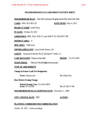
NEIGHBORHOOD PLAN AMENDMENT REVIEW SHEET NEIGHORHOOD PLAN: Oak Hill Combined Neighborhood Plan (East Oak Hill) CASE#: NPA-2025-0025.02 DATE FILED: July 14, 2025 PROJECT NAME: South Town PC DATE: October 28, 2025 ADDRESS/ES: 4980, 5016, 5020 1/2, and 5030 W US 290 HWY WB DISTRICT AREA: 8 SITE AREA: 7.008 acres OWNER/APPLICANT: Lamy South Towne, Ltd AGENT: Armbrust & Brown, PLLC (Richard T. Suttle, Jr.) CASE MANAGER: Maureen Meredith PHONE: 512-974-2695 STAFF EMAIL: Maureen.Meredith@austintexas.gov TYPE OF AMENDMENT: Change in Future Land Use Designation From: Commercial To: Mixed Use Base District Zoning Change Related Zoning Case: C14-2025-0079 From: CS-CO-NP To: CS-MU-V-NP NEIGHBORHOOD PLAN ADOPTION DATE: December 11, 2008 CITY COUNCIL DATE: TBD ACTION: PLANNING COMMISSION RECOMMENDATION: October 28, 2025 – (action pending) 15 NPA-2023-0025.02 - 5524 W. US Hwy 290; District 81 of 34 STAFF RECOMMENDATION: Staff supports the Applicant’s request for Mixed Use land use. BASIS FOR STAFF’S RECOMMENDATION: The property is located at the northeast corner of West Texas Hwy 71/Southwest Parkway and South MOPAC Expressway. The site currently has a Best Buy store with several other smaller businesses. The applicant proposes to rezone the property to allow for a multifamily development. The proposed residential development will provide additional housing for the City and the planning area. The applicant’s request to change the future land use map from Commercial to Mixed Use is supported by staff because this land use is appropriate adjacent to two major highways. 15 NPA-2023-0025.02 - 5524 W. US Hwy 290; District 82 of 34 Below are goals from the Oak Hill Combined Neighborhood Plan staff believe supports the applicant’s request: Land Use Goals: 15 NPA-2023-0025.02 - 5524 W. US Hwy 290; District 83 of 34 Housing Goals: LAND USE DESCRIPTIONS: EXISTING LAND USE: Commercial Lots or parcels containing retail sales, services, hotel/motels and all recreational services that are predominantly privately owned and operated for profit (for example, theaters and bowling alleys). Included are private institutional uses (convalescent homes and rest homes in which medical or surgical services are not a main function of the institution), but not hospitals. Purpose 1. Encourage employment centers, commercial activities, and other non‐ residential development to locate along major thoroughfares; and 2. Reserve limited areas for intense, auto‐oriented commercial uses that are generally not compatible with residential or mixed use environments. Application 1. Focus the highest intensity commercial and industrial activities along freeways and major highways; and 15 NPA-2023-0025.02 - 5524 W. US Hwy 290; District 84 of 34 2. Should be used in areas with good transportation access such as frontage roads and arterial roadways, which are generally not suitable for residential development. PROPOSED LAND USE: Mixed Use - An area that is appropriate for a mix of residential and non‐residential uses. Purpose 1. Encourage more retail and commercial services within walking distance of residents; 2. Allow live‐work/flex space on existing commercially zoned land in the neighborhood; 3. Allow a mixture of complementary land use types, which may include housing, retail, offices, commercial services, and civic uses (with the exception of government offices) to encourage linking of trips; 4. Create viable development opportunities for underused center city sites; 5. Encourage the transition from non‐residential to residential uses; 6. Provide flexibility in land use standards to anticipate changes in the marketplace; 7. Create additional opportunities for the development of residential uses and affordable housing; and 8. Provide on‐street activity in commercial areas after 5 p.m. and built‐in customers for local businesses. Application 1. Allow mixed use development along major corridors and intersections; 2. Establish compatible mixed‐use corridors along the neighborhood’s edge 3. The neighborhood plan may further specify either the desired intensity of commercial uses (i.e. LR, GR, CS) or specific types of mixed use (i.e. Neighborhood Mixed Use Building, Neighborhood Urban Center, Mixed Use Combining District); 4. Mixed Use is generally not compatible with industrial development, however it may be combined with these uses to encourage an area to transition to a more complementary mix of development types; 5. The Mixed Use (MU) Combining District should be applied to existing residential uses to avoid creating or maintaining a non‐conforming use; and 15 NPA-2023-0025.02 - 5524 W. US Hwy 290; District 85 of 34 6. Apply to areas where vertical mixed use development is encouraged such as Core Transit Corridors (CTC) and Future Core Transit Corridors. Yes No Imagine Austin Decision Guidelines Complete Community Measures Imagine Austin Growth Concept Map: Located within or adjacent to an Imagine Austin Activity Center, Imagine Austin Activity Corridor, or Imagine Austin Job Center as identified the Growth Concept Map. Name(s) of Activity Center/Activity Corridor/Job Center: Yes Mobility and Public Transit: Located within 0.25 miles of public transit stop and/or light rail station. • Bus routes along the service road Yes Mobility and Bike/Ped Access: Adjoins a public sidewalk, shared path, and/or bike lane. • Sidewalks along the frontage road. Yes Connectivity, Good and Services, Employment: Provides or is located within 0.50 miles to goods and services, and/or employment center. Yes Connectivity and Food Access: Provides or is located within 0.50 miles of a grocery store/farmers market. • Sam’s Club • Walmart Supercenter south side of US Hwy 290 Connectivity and Education: Located within 0.50 miles from a public school or university. No Yes Connectivity and Healthy Living: Provides or is located within 0.50 miles from a recreation area, park or walking trail. • Gaines Creek Greenbelt to the north • Proposed urban trails • No Connectivity and Health: Provides or is located within 0.50 miles of health facility (ex: hospital, urgent care, doctor’s office, drugstore clinic, and/or specialized outpatient care.) • 1.6 miles from Baylor Scott & White Medical Center - Austin, 5245 W US Hwy 290 Service Rd, Austin, TX 78735 • 2.8 miles from CareNow Urgent Care - Southwest Austin, 5033 US-290, Austin, TX 78746 No Housing Affordability: Provides a minimum of 10% of units for workforce housing (80% MFI or less) and/or fee in lieu for affordable housing. Yes Housing Choice: Expands the number of units and housing choice that suits a variety of household sizes, incomes, and lifestyle needs of a diverse population (ex: apartments, triplex, granny flat, live/work units, cottage homes, and townhomes) in support of Imagine Austin and the Strategic Housing Blueprint. • Applicant proposes approx. 1,000 residential units. Yes Mixed use: Provides a mix of residential and non-industrial uses. • The proposed zoning of CS-MU-V-NP would allow for a mixed use development No No Culture and Creative Economy: Provides or is located within 0.50 miles of a cultural resource (ex: library, theater, museum, cultural center). Culture and Historic Preservation: Preserves or enhances a historically and/or culturally significant site. 15 NPA-2023-0025.02 - 5524 W. US Hwy 290; District 86 of 34 No Not known No 7 Creative Economy: Expands Austin’s creative economy (ex: live music venue, art studio, film, digital, theater.) Workforce Development, the Economy and Education: Expands the economic base by creating permanent jobs, especially in industries that are currently not represented in particular area or that promotes a new technology, and/or promotes educational opportunities and workforce development training. Industrial Land: Preserves or enhances industrial land. Number of “Yeses” Proximity to Imagine Austin Activity Centers and Corridors 15 NPA-2023-0025.02 - 5524 W. US Hwy 290; District 87 of 34 Proximity to Public Parks 15 NPA-2023-0025.02 - 5524 W. US Hwy 290; District 88 of 34 Proximity to Public Transportation 15 NPA-2023-0025.02 - 5524 W. US Hwy 290; District 89 of 34 Proposed Urban Trails Map IMAGINE AUSTIN GROWTH CONCEPT MAP Definitions Neighborhood Centers - The smallest and least intense of the three mixed-use centers are neighborhood centers. As with the regional and town centers, neighborhood centers are walkable, bikable, and supported by transit. The greatest density of people and activities in neighborhood centers will likely be concentrated on several blocks or around one or two intersections. However, depending on localized conditions, different neighborhood centers can be very different places. If a neighborhood center is designated on an existing commercial area, such as a shopping center or mall, it could represent redevelopment or the addition of housing. A new neighborhood center may be focused on a dense, mixed-use core surrounded by a mix of housing. In other instances, new or redevelopment may occur incrementally and concentrate people and activities along several blocks or around one or two intersections. Neighborhood centers will be more locally focused than either a regional or a town center. Businesses and services—grocery and department stores, doctors and dentists, shops, branch libraries, dry cleaners, hair salons, schools, restaurants, and other small and local businesses—will generally serve the center and surrounding neighborhoods. Town Centers - Although less intense than regional centers, town centers are also where many people will live and work. Town centers will have large and small employers, although fewer than in regional centers. These employers will have regional customer and employee bases, and provide goods and services for the center as well as the surrounding areas. The buildings found in a town center will range in size from one-to three-story houses, duplexes, 15 NPA-2023-0025.02 - 5524 W. US Hwy 290; District 810 of 34 townhouses, and rowhouses, to low-to midrise apartments, mixed use buildings, and office buildings. These centers will also be important hubs in the transit system. Regional Centers - Regional centers are the most urban places in the region. These centers are and will become the retail, cultural, recreational, and entertainment destinations for Central Texas. These are the places where the greatest density of people and jobs and the tallest buildings in the region will be located. Housing in regional centers will mostly consist of low to high-rise apartments, mixed use buildings, row houses, and townhouses. However, other housing types, such as single-family units, may be included depending on the location and character of the center. The densities, buildings heights, and overall character of a center will depend on its location. Activity Centers for Redevelopment in Sensitive Environmental Areas - Five centers are located over the recharge or contributing zones of the Barton Springs Zone of the Edwards Aquifer or within water-supply watersheds. These centers are located on already developed areas and, in some instances, provide opportunities to address long-standing water quality issues and provide walkable areas in and near existing neighborhoods. State-of-the-art development practices will be required of any redevelopment to improve stormwater retention and the water quality flowing into the aquifer or other drinking water sources. These centers should also be carefully evaluated to fit within their infrastructural and environmental context. Job Centers - Job centers accommodate those businesses not well-suited for residential or environmentally- sensitive areas. These centers take advantage of existing transportation infrastructure such as arterial roadways, freeways, or the Austin-Bergstrom International airport. Job centers will mostly contain office parks, manufacturing, warehouses, logistics, and other businesses with similar demands and operating characteristics. They should nevertheless become more pedestrian and bicycle friendly, in part by better accommodating services for the people who work in those centers. While many of these centers are currently best served by car, the growth Concept map offers transportation choices such as light rail and bus rapid transit to increase commuter options. Corridors - Activity corridors have a dual nature. They are the connections that link activity centers and other key destinations to one another and allow people to travel throughout the city and region by bicycle, transit, or automobile. Corridors are also characterized by a variety of activities and types of buildings located along the roadway — shopping, restaurants and cafés, parks, schools, single-family houses, apartments, public buildings, houses of worship, mixed-use buildings, and offices. Along many corridors, there will be both large and small redevelopment sites. These redevelopment opportunities may be continuous along stretches of the corridor. There may also be a series of small neighborhood centers, connected by the roadway. Other corridors may have fewer redevelopment opportunities, but already have a mixture of uses, and could provide critical transportation connections. As a corridor evolves, sites that do not redevelop may transition from one use to another, such as a service station becoming a restaurant or a large retail space being divided into several storefronts. To improve mobility along an activity corridor, new and redevelopment should reduce per capita car use and increase walking, bicycling, and transit 15 NPA-2023-0025.02 - 5524 W. US Hwy 290; District 811 of 34 use. Intensity of land use should correspond to the availability of quality transit, public space, and walkable destinations. Site design should use building arrangement and open space to reduce walking distance to transit and destinations, achieve safety and comfort, and draw people outdoors. BACKGROUND: The applicant proposes to change the land use on the future land use map (FLUM) from Commercial to Mixed Use land use. The applicant proposes to change the zoning on the property from CS-CO-NP (General Commercial Services district – Conditional Overlay combining district – Neighborhood Plan) to CS-MU-V-NP (General Commercial Services district – Mixed Use combining district – Vertical Mixed Use Building combining district – Neighborhood Plan). For more information on the proposed zoning, see case report C14-2025-0079. PUBLIC MEETINGS: The ordinance-required community meeting was virtually held on August 13, 2025. The recorded meeting can be found here: https://publicinput.com/neighborhoodplanamendmentcases. Approximately 37 meeting notices were mailed to people with utility accounts (renters), property owners, neighborhood and environmental groups within 500 feet of the property. Two city staff members from the Austin Planning attended the meeting, Maureen Meredith and Mark Walters. The applicant’s agents, Richard T. Suttle, Jr., Kelly Wright, and Amanda Morrow from Armbrust and Brown attended along with three members from the neighborhood. Below are highlights from Richard T. Suttle’s presentation: • The site is about 7 acres, it is where the Best Buy store is located. • The family leases the property to Best Buy. As the lease matures, the owners are looking at other options in the event the Best Buy does not renew the lease. • The family is thinking about putting a multifamily development, with about 1,000 units, but they have not done any official calculations, so they don’t know exactly how many units they could fit on the property. Q: Best Buy store offers great benefits to the neighborhood. When would the lease be up? A: Regarding the Terms of the Lease, we need to get back to you on this and to also find out if we can make this information public. Q: Would you want to keep the CO on the property? A: We are interested in looking into carrying over the CO. We will talk to the landowner about this. I don’t see why we wouldn’t want to carry over most, if not all, of these conditions. Q: Why not use the SB 840, which allows for mixed use and multifamily residential uses instead of rezoning the property? A: When we started this process, SB 840 had not passed, so we just moved forward with this application. Also, we don’t know exactly how SB 840 would work so we decided to move forward with a process that we know versus an outcome we are not sure of. Right now, we are only interested in a maximum of 60 feet. 15 NPA-2023-0025.02 - 5524 W. US Hwy 290; District 812 of 34 Q: How many buildings are proposed for a proposed 1,000-unit project? A: We don’t have any designs yet. Q: Does this development include affordable housing? A: No, I don’t think so. The owner has not talked about including affordable housing units. Q: What happens to the property when MOPAC is extended? Would that affect his property if they need ROW? A: Nobody has approached the owner yet about easements. Comments: • This intersection is crowded as it is, then you plan to add approximately 1,000 residential units, with maybe some commercial uses, this could be a problem. • This is an important commercial area for the area. We would love to see this property developed with more commercial uses. This would be a big loss. 15 NPA-2023-0025.02 - 5524 W. US Hwy 290; District 813 of 34 Applicant Summary Letter from Application 15 NPA-2023-0025.02 - 5524 W. US Hwy 290; District 814 of 34 15 NPA-2023-0025.02 - 5524 W. US Hwy 290; District 815 of 34 Oak Hill NPCT Postponement Request for the October 28, 2025 PC hearing date 15 NPA-2023-0025.02 - 5524 W. US Hwy 290; District 816 of 34 From: Meredith, Maureen Sent: Tuesday, October 21, 2025 11:17 AM To: Amanda Hendrix <ahendrix@abaustin.com>; rsuttle@abaustin.com; Kelly Wright <KWright@abaustin.com> Cc: Tomko, Jonathan <Jonathan.Tomko@austintexas.gov>; Land Use Liaison <LandUseLiaison@austintexas.gov>; Harden, Joi <Joi.Harden@austintexas.gov>; Thomas, Eric <Eric.Thomas@austintexas.gov> Subject: RE: OHNPCT PP Request: NPA-2025-0025.02 and C14-2025-0079 South Towne Planning Commission Oct 28, 2025 Hi, Amanda, Richard, and Kelly: Leigh requests a PP to the December 9th PC hearing date. See her email below. Please let us know if you are OK with this date. Thanks. Maureen From: LEIGH ZIEGLER Sent: Tuesday, October 21, 2025 10:58 AM To: Meredith, Maureen <Maureen.Meredith@austintexas.gov> Cc: District 8 <District8@austintexas.gov>; Montgomery, Julie <Julie.Montgomery@austintexas.gov>; Tomko, Jonathan <Jonathan.Tomko@austintexas.gov> Subject: Re: NPA-2025-0025.02 and C14-2025-0079 South Towne Planning Commission Oct 28, 2025 Maureen, If those are our only options, the Dec 9, 2025 date would provide the most time for Council to elaborate on the interaction of code upon overall development and benefit. Please request Dec 09. How do you recommend getting an opinion upon the use of 25-2, subch E, Article 4.3.5, as an opt-in for this case application? Leigh Thank you, Leigh 15 NPA-2023-0025.02 - 5524 W. US Hwy 290; District 817 of 34 Letter of Recommendation from the Neighborhood Plan Contact Team (NPCT) 15 NPA-2023-0025.02 - 5524 W. US Hwy 290; District 818 of 34 Letter of Recommendation from the Neighborhood Plan Contact Team (NPCT) 15 NPA-2023-0025.02 - 5524 W. US Hwy 290; District 819 of 34 Letter of Recommendation from the Neighborhood Plan Contact Team (NPCT) 15 NPA-2023-0025.02 - 5524 W. US Hwy 290; District 820 of 34 Letter of Recommendation from the Neighborhood Plan Contact Team (NPCT) 15 NPA-2023-0025.02 - 5524 W. US Hwy 290; District 821 of 34 Letter of Recommendation from the Neighborhood Plan Contact Team (NPCT) 15 NPA-2023-0025.02 - 5524 W. US Hwy 290; District 822 of 34 Letter of Recommendation from the Neighborhood Plan Contact Team (NPCT) 15 NPA-2023-0025.02 - 5524 W. US Hwy 290; District 823 of 34 Site 15 NPA-2023-0025.02 - 5524 W. US Hwy 290; District 824 of 34 15 NPA-2023-0025.02 - 5524 W. US Hwy 290; District 825 of 34 15 NPA-2023-0025.02 - 5524 W. US Hwy 290; District 826 of 34 15 NPA-2023-0025.02 - 5524 W. US Hwy 290; District 827 of 34 15 NPA-2023-0025.02 - 5524 W. US Hwy 290; District 828 of 34 15 NPA-2023-0025.02 - 5524 W. US Hwy 290; District 829 of 34 Richard Suttle’s Presentation at the Virtual Community Meeting 15 NPA-2023-0025.02 - 5524 W. US Hwy 290; District 830 of 34 15 NPA-2023-0025.02 - 5524 W. US Hwy 290; District 831 of 34 15 NPA-2023-0025.02 - 5524 W. US Hwy 290; District 832 of 34 15 NPA-2023-0025.02 - 5524 W. US Hwy 290; District 833 of 34 Correspondence Received (No correspondence received) 15 NPA-2023-0025.02 - 5524 W. US Hwy 290; District 834 of 34