06 and 07 Information Submitted by Paul Stables (Property Owner) — original pdf
Backup
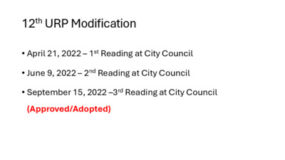
12th URP Modification • April 21, 2022 – 1st Reading at City Council • June 9, 2022 – 2nd Reading at City Council • September 15, 2022 –3rd Reading at City Council (Approved/Adopted) April 21, 2022 – 1st Reading at City Council Draft URP posted as backup June 9, 2022 – 2nd Reading at City Council Draft URP posted as backup July 28, 2022 – 3rd Reading at City Council (NCCD) Version 1 Version 2 Version 3 Adopted URP URBAN RENEWAL BOARD RECOMMENDATION 20250915 Date: September 15, 2025 Subject: Urban Renewal Plan Amendment – Cocktail Lounge as conditional use for 1201 E 11th St. Motioned By: Watson Seconded By: Motwani Recommendation The Urban Renewal Board remains neutral and abstains from making a recommendation, either affirmative or negative, regarding the request to amend the Urban Renewal Plan for East 11th and 12th Street brought forth by the owner of the property at 1201 E 11th St. The Urban Renewal Board authorizes Hunter Maples, Board Liaison to attend and represent the Urban Renewal Agency at any Board and Commission or City Council meetings related to the request. See attached letter for further description. Vote 5-1-0 For: Escobar, Tetey, Watson, Motwani, Davis Against: Pierce Abstain: None Absent: Hawkins Attest: Hunter Maples, Board Liaison 4118908.v1 1 of 3 To: From: Date: Subject: Mayor & City Council of Austin Urban Renewal Board September 15, 2025 Context for URB Recommendation regarding Cocktail Lounge as a conditional use for the property at 1201 E 11th St. The owner of the property at 1201 E 11th St requested an amendment to the Urban Renewal Plan (URP) to add Cocktail Lounge as a conditional use. The current URP, aligned with the East 11th St Neighborhood Conservation Combining District (NCCD), allows Cocktail Lounge as a conditional use in subdistrict 1 with the condition that it is allowed on property located on the 900 and 1100 Blocks of East 11th Street (Blocks 16 and 18). The recommendation of the Urban Renewal Board (URB) is as follows: The Urban Renewal Board remains neutral and abstains from making a recommendation, either affirmative or negative, regarding the request to amend the Urban Renewal Plan for East 11th and 12th Street brought forth by the owner of the property at 1201 E 11th St. The following provides context regarding this recommendation. The URB directed staff to provide information regarding the 12th modification to the URP to ensure that the use that the owner of the property at 1201 E 11th Street has requested be added as a conditional use for that property was not previously removed in error through actions taken by the URB or inadvertently by any other party during the prior modification process. The URB was of the position that had the use been removed in error or inadvertently, it might be willing to support the requested amendment to restore such use. Staff found that the action revising uses in subdistrict 1 of 11th Street, including on 1201 E 11th Street, appeared to have been the subject of a deliberative process by City Council and had not been made inadvertently or in error, and reported the same to URB. The URB engaged in a multiyear effort to update the URP and the East 11th and 12th Street NCCDs resulting in the adoption of the 12th modification of the URP. The goal of this effort was to update the zoning regulations to support the URP and to provide consistency and clarity regarding entitlements. The Board’s recommendations were formed with the assistance of consultants, staff, and community input. The URB refined the list of neighborhood-oriented and pedestrian-friendly land uses in the URP and NCCDs to support active streets that serve the community. In response to concerns from stakeholders about the reduction of uses allowed for some properties (which to the URB’s recollection included requests for reductions relating to alcohol-related uses), in its recommendation to council dated November 15, 2021, the URB made clear that it “supported proposed regulations which continued to allow uses (permitted or conditional) under current regulations if they support the goals of the URP,” which aligned with the URB’s stated intent that existing uses within the URP not be modified as part of the updating process absent some clear need or direction from staff or City Council. The initial draft of the URP presented to City Council at first reading on April 21, 2022 contained the following language: A Cocktail Lounge is a permitted use limited to the ground floor of a building located at 1133 E 11th Street, 1104 East 11th Street and 1808-1812 East 12th Street. A cocktail lounge use is otherwise prohibited except as an accessory use to a hotel/motel use. 4118908.v1 2 of 3 Following that first reading, Council Member Natasha Harper Madison proposed an amendment to the URP and NCCDs that would make Cocktail Lounge use a conditional use in subdistrict 1 of the East 11th street NCCD and to make Cocktail Lounge use a permitted use on the 900 and 1100 blocks of 11th Street (Blocks 16 and 18). The URB understood that Cocktail Lounge use previously had been a conditional use in subdistrict 1, and was in support of the revisions proposed in the amendment. The draft of the URP presented to City Council at second reading on June 9, 2022 incorporated the changes approved by Council on April 21. The question of Cocktail Lounge use on both East 11th Street and East 12th Street then appeared to be the subject of further deliberations by both the Planning and Zoning Commission and City Council. Following those deliberations, at third reading of the NCCDs on July 28, 2022 3 versions of the ordinance were presented to City Council with language containing slightly differing language relating to Cocktail Lounge use in the URP area. Ultimately, Council approved the version containing the language that appears in the current URP. The position of the URB throughout the modification process consistently was that its intent was not to significantly modify existing uses, and was to streamline and update the URP and to make conforming recommendations to the NCCDs to make those documents easier to understand and use for property owners and for future projects. The URB’s understanding had been that the language ultimately adopted in the URP did not change Cocktail Lounge use within subdistrict 1 of the 11th Street NCCD – it previously had been a conditional use, and appears to have remained so – other than to make that use permitted with respect to Block 16 and Block 18 in anticipation of the City’s potential future development of those properties. The property owner submitting the zoning change application believes that this conditional use was removed from their property. The URB is not in a position to determine whether this actually has occurred or not, but to the extent that it did, that removal does not appear to have been inadvertent and instead was the result of a deliberative process occurring after the URB made its recommendations. Consequently the URB is abstaining from making a recommendation in favor of or against the requested amendment, as it believes it previously made its position clear on this issue through its prior recommendations, and that as this issue was separately deliberated by City Council during the prior modification process subsequent to those recommendations, City Council is in the best position to revisit the language currently contained in the URP regarding this use. 4118908.v1 3 of 3 Case no C14-2025-0030 - 1201 E 11st Austin, 78702 September 19 2025 Dear Commissioners, This case that will be before you on September 23rd, is a result of ordinance 20220728-163 adopted July 28 2022, which replaced ordinance 910620-C. I was not notified in any way prior to this ordinance being adopted that my land use or entitlement was being removed, even though city staff stated that a notification would have been sent to me and other landowners. Had I been aware I would have protested or asked for compensation for the reduction and devaluation of my property rights. City council as part of its responsibilities has the right to regulate zoning, but in this case the conditional use was not just removed, it was given exclusively to the two city owned blocks 16 and 18, which are destined to become a $150 million plus affordable housing and mixed use development, that will have 2 up to 4 bars/venues. https://communityimpact.com/austin/south-central-austin/development/2024/07/23/112m-mixed- use-redevelopment-with-affordable-housing-artistic-space-coming-to-east-austin/ I am seeking restoration of my property rights regarding the conditional use for a cocktail lounge or the same uses as blocks 16 and 18. Under 910620-C, a cocktail lounge was classified as a conditional use. (see page 69) Under the new Ordinance 20220728-163, the conditional use for a cocktail lounge became prohibited on East 11 St., except blocks 16 and 18, which was given this conditional use exclusively (page 9). Please note, when reading the below uses, you may interpret that conditional uses on E. 11th are conditional, and blocks 16 and 18 are allowed, but after a 7 month city staff investigation, their interpretation is only blocks 16 and 18 have the conditional use zoning on E. 11th and no one else. To be 100% clear on city staff interpretation, the ordinance is explained by Eric Thomas of planning department. There are no reasons given to date from city staff, why council removed my property rights and gave ONLY to two city owned properties, just that council intended to do so. At a September 16 2024 URB meeting, the URB voted to initiate a rezoning of my property: DRAFT MINUTES URBAN RENEWAL BOARD MEETING September 16, 2024, 6:00 P.M. PERMITTING AND DEVELOPMENT CENTER, ROOM 1401/1402 6310 WILHELMINA DELCO DR. AUSTIN, TEXAS 78752 DISCUSSION AND ACTION ITEMS 5. Discuss and approve a recommendation to City Council regarding the request to amend the Urban Renewal Plan to allow additional uses at 1201 E 11th St (Paul Stables) Following discussion, on Chair Escobar’s motion, Vice Chair Pierce’s second, the URB voted to initiate the process to restore prior rights, to the same as when Paul Stables purchased his parcel, on a 5-0-0 vote On August 18 2025, the URB was instructed by Eric Thomas of the planning department, to vote again, with three options Support, Abstain or Not Support. URBAN RENEWAL BOARD RECOMMENDATION 20250915 Date: September 15, 2025 11th Subject: Urban Renewal Plan Amendment – Cocktail Lounge as conditional use for 1201 E St. The URB chose to abstain, and reverse their support, on the basis that they had concerns in relation to their role in guiding parts of the ordinance, but they NEVER recommended any land rights be taken from landowners and that whoever drafted the final ordinance within the city staff and council removed my land rights. On Page 3 of the recommendation, the URB did NOT intend to modify existing uses, and their interpretation of the ordinance is that nothing changed, which is incorrect. The uses DID change and blocks 16 and 18 were given the exclusive conditional use. Secondly, the URB states they were unable to determine whether the conditional was removed or not. This is confirmed by eric Thomas’s emails to me above, and was also confirmed by Eric Thomas at the previous URB meeting August 18, whereby Mr Thomas confirmed that conditional use was only allowed on Blocks 16 and 18. I respectfully request the planning commission approve the restoration of conditional use for a cocktail bar on my property at 1201 E 11st, Austin, 78702. I look forward to answering any questions at the upcoming meeting, and if you have any questions, please feel free to contact me. Kind regards Paul Stables 512 826 1043 MINUTES URBAN RENEWAL BOARD MEETING September 16, 2024, 6:00 P.M. PERMITTING AND DEVELOPMENT CENTER, ROOM 1401/1402 6310 WILHELMINA DELCO DR. AUSTIN, TEXAS 78752 CURRENT BOARD MEMBERS/COMMISSIONERS: Manuel Escobar, Chair Darrell W, Pierce, Vice Chair Amit Motwani Byron Davis Jacqueline Watson Kobla Tetey Tam Hawkins Board Members/Commissioners in Attendance: Vice Chair Darrell W. Pierce, and Commissioners Kobla Tetey, and Byron Davis. Commissioner Tam Hawkins arrived at 6:21pm. Board Members/Commissioners in Attendance Remotely: No members attended remotely. Board Members Absent/off the dais at call to order: Commissioners Amit Motwani and Jacqueline Watson were absent. CALL TO ORDER: Chair Escobar, called the meeting to order at 6:09 pm with four members present. PUBLIC COMMUNICATION: GENERAL The first 10 speakers who registered to speak no later than noon the day before the meeting, if speaking virtually, or who signed up prior to the meeting being called to order if speaking in person, will each be allowed a three-minute allotment to address their concerns regarding items not posted on the agenda. Paul Stables addressed the board regarding a zoning change to his property adjacent to East 11th Street. 1 of 3 APPROVAL OF MINUTES 1. Approve the minutes of the Urban Renewal Board’s (URB’s) regular-called meeting on August 19, 2024. On Commissioner Tetey’s motion, Commissioner Davis’s second, the August 19, 2024, minutes were approved on a 4-0-0 vote. DISCUSSION ITEMS 2. 3. 4. Discussion related to updates on future development of Blocks 16 & 18 from Rally Austin (formerly Austin Economic Development Corporation), including project status and anticipated timeline (Anne Gatling Haynes, Rally Austin) Anne Gatling Hayes, Rally Austin, gave the updates. Update and discussion related to the annual budget process (Mandy DeMayo, Interim Director, Housing Department) Mandy DeMayo, Interim Director, Housing Department, gave the update. Update and discussion regarding the African American Cultural Heritage District (AACHD) Resolution No. 20210902-048 (Matthew Schmidt, Global Business Expansion Division Program Manager III, Economic Development Department) Matthew Schmidt gave the update. Commissioner Byron Davis volunteered as representative to serve on the AACHD coalition. DISCUSSION AND ACTION ITEMS 5. Discuss and approve a recommendation to City Council regarding the request to amend the Urban Renewal Plan to allow additional uses at 1201 E 11th St (Paul Stables) Following discussion, on Chair Escobar’s motion, Vice Chair Pierce’s second, the URB voted to initiate the process to restore prior rights, to the same as when Paul Stables purchased his parcel, on a 5-0-0 vote. 2 of 3 EXECUTIVE SESSION Chair Escobar recessed the regular meeting and called the Executive Session to order at 6:44 pm. 6. 7. 8. Discuss legal matters related to the purchase, exchange, lease, or value of an interest in Blocks 16 and 18 located on East 11th Street in Austin (Private consultation with legal counsel - Section 551.071 of the Texas Government Code) Discuss real estate matters related to the purchase, exchange, lease, or value of an interest in Blocks 16 and 18 located on East 11th Street in Austin (Real Property - Section 551.072 of the Texas Government Code) Discuss legal matters related to a potential conflict of interest with AEDC/RallyAustin (Private consultation with legal counsel – Section 551.071 of the Texas Government Code). Chair Escobar ended executive session and reconvened the regular meeting at 7:17pm. FUTURE AGENDA ITEMS No new future agenda items were discussed. ADJOURNMENT Chair Escobar adjourned the meeting without objection at 7:17pm. The minutes of the URB’s September 16, 2024, meeting were approved on Commissioner Motwani’s motion, Watson’s second on a 5-0-0 vote at the October 21, 2024, meeting. Commissioners Hawkins and Tetey were absent. The City of Austin is committed to compliance with the American with Disabilities Act. Reasonable modifications and equal access to communications will be provided upon request. Meeting locations are planned with wheelchair access. If requiring Sign Language Interpreters or alternative formats, please give notice at least 2 days (48 hours) before the meeting date. Please call Hunter Maples at the Housing Department, at (512) 974-3120, for additional information; TTY users route through Relay Texas at 711. For more information on the Urban Renewal Board, please contact Hunter Maples at (512) 974- 3120. 3 of 3 DRAFT URBAN RENEWAL PLAN FOR THE EAST 11TH AND 12TH STREETS URBAN RENEWAL PLAN AREA Page 1 of 31 TABLE OF CONTENTS 1. Boundary Description 2. History 2.1 Accomplishments 3. Vision, Purpose, Authority and Scope 4. Redevelopment Strategy 5. Applicability of NCCD Controls 6. Land Use 7. Relocation of Persons, Businesses (including individuals and families, business concerns, and others displaced by the project) 8. Duration and Modification Procedures of URP Appendices: Appendix A: East 11th and 12th Street Urban Renewal Plan; Amendments Appendix B: East 11th Street and East 12th Street Neighborhood Conservation Combining District (NCCDs); Amendments Abbreviations commonly used in the document: URP – Urban Renewal Plan URA-Urban Renewal Agency ARA – Austin Revitalization Authority Note: Some of the tables and figures from the original 1999 Urban Renewal Plan have been deleted or modified, as they were no longer accurate or relevant. The original plan is available at this website: http://www.austintexas.gov/department/urban-renewal-plan Page 2 of 31 EAST 11 TH & 12TH STREETS URBAN RENEWAL PLAN (URP) 1. BOUNDARY DESCRIPTION The formal boundaries of the East 11th and 12th Streets Urban Renewal Area are set forth in the documents listed in Appendix A and the ordinance approving this URP. In general, the boundaries are: The East 11th Street Corridor, including properties within one-half block of the north frontage of East 11th Street and south frontage of Juniper Street, from Branch Street on the west to Navasota Street on the east; and properties within one-half block of the south frontage of East 11th, from San Marcos Street on the west to Navasota Street on the east. The East 12th Street Corridor, including properties within one-half block of the north frontage of East 12th and between the IH-35 Northbound Frontage Road on the west to Poquito Street to the east; and properties within one-half block of the south frontage of East 12th Street, from Branch Street on the west to Poquito Street on the east. 2. HISTORY This East 11th and 12th Streets Urban Renewal Plan (“URP" also referred to as the East 11th and 12th Streets Community Redevelopment Plan or “CRP”), is a comprehensive document defining the official public policy guidelines of the City of Austin (City) for driving public and private redevelopment actions within the East 11th and 12th Streets Urban Renewal Area in compliance with Texas Local Government Code, Chapter 374. The URP’s original conceptual approaches and strategies for the entire Central East Austin area were defined as part of the Central East Austin Master Plan (“Master Plan”) prepared in January 1999, by representative members and organizations of the Central East Austin community with the professional and technical assistance of the Crane Urban Design Team and the Austin Revitalization Authority (ARA). The Master Plan provided a general framework for developing the Central East Austin Neighborhood Plan which was adopted by Austin City Council under Ordinance No. 011213-41. Two critical Subareas of the Master Plan are the East 11th and 12th Street Corridors, which were identified to be the location of much of the new commercial/office redevelopment called for in the Master Plan. In November 1997, the City of Austin (City) declared this area to be slum and blighted and designated these corridors as appropriate for an urban renewal project. Under Chapter 374 of the Texas Local Government Code, the Urban Renewal Agency (URA) and the City are granted a series of redevelopment roles and responsibilities regarding urban renewal areas including approval of projects for compliance with an urban renewal plan and the use of eminent domain powers. As originally adopted in 1999, the URP was intended to identify and implement mechanisms to eliminate the negative forces of urban blight, distress and impaired development within the area and to pursue a Page 3 of 31 fresh, self-determined vision of Central East Austin as a self-sustaining, progressive community for the 21st century. The overall goals and action priorities of this URP reflected a broad consensus of residents, businesses, property owners, institutions, and community activists. This consensus was the result of substantial cumulative planning and revitalization efforts over a period of three years and has been reconsidered and reestablished through this updated URP. This URP defines specific redevelopment projects and associated regulatory controls intended to assure quality, compatible, mixed-use development along these critical commercial arteries. The redevelopment process has been guided by the URA consistent with state law, the Master Plan, the URP, and a Development Agreement that was negotiated between the City, URA, and the Austin Revitalization Authority (ARA). In order to carry out specific redevelopment projects identified in the URP, the City of Austin secured a $9,035,000 Section 108 Loan Guarantee Assistance Program (Section 108) from the U.S. Department of Housing and Urban Development (HUD) in December 1999. Also in 1999, the City, the URA and the ARA entered into an Acquisition, Development and Loan Agreement (commonly referred to as the “Tri-Party Agreement”) that identified the roles and responsibilities of the City, URA and the ARA as it related to the redevelopment activities of the URP area. This agreement expired in September 30, 2010. The City, in partnership with the URA, is now carrying out the redevelopment activities called for under the URP. 2.1. ACCOMPLISHMENTS Since the adoption of the 1999 Plan, through efforts of the City of Austin, Urban Renewal Agency and Austin Revitalization Authority the following has been accomplished related to the Plan area: Historic Preservation ◼ Haehnal Building located at 1101 East 11th Street ◼ Arnold Bakery located at 1010 East 11th Street ◼ Chapman House located at 901 East 12th Street ◼ Connelly-Yerwood House, a.k.a. the Pink House located at 1115 East 12th Street ◼ Dedrick-Hamilton House located at 912 East 11th Street: This house along with the African American Cultural and Heritage Facility are the flagship buildings for the African American Cultural and Heritage District. ◼ Travis County Negro Agricultural Extension Office (a.k.a., Herman-Schieffer House and/or East Room) located at 1154 Lydia Street ◼ Completion of East Austin Historic Resources Survey (by City of Austin through Hardy-Heck- Moore, Inc.) to identify potentially eligible structures and historic districts in areas including the URP area - copy available at this link: https://www.austintexas.gov/page/historic-survey ◼ Support of in-place renovation of historic landmarks in URP area through letter dated April 15, 2019; additional preservation efforts to IQ Hurdle House located at 1416 E 12th Street followed Page 4 of 31 Infrastructure Improvements – East 11th Street ◼ Streetscape improvements, i.e. sidewalks, furniture ◼ Upgraded the water and wastewater lines on East 11th and Juniper streets ◼ Converted utility and telecommunication lines from overhead to underground Transportation and Streetscape Improvements – East 11th Street ◼ Completed streetscaping beautification project including widening of sidewalks, installing decorative light posts, the 11th Street Archway and the Dr. Charles Urdy Plaza that includes a clock tower and a tile mosaic art wall. ◼ Completed construction of a 10-space community parking facility at 1205 E 11th Street ◼ Completed construction of a 20-space community parking facility at 1400 E 12th Street Residential Development – East 11th Street ◼ Juniper Townhomes – Located on the south side of the 1000 Block of East 11th Street, between Curve Street and Olive Street. This project consists of 16 units, two of which are owned by the Austin Housing Finance Corporation and will be sold to households at or below 80% of the median family income (MFI) for the Austin-Round Rock area. Residential Development – East 12th Street ◼ 1001-1105 East 12th Street – Through a competitive process, the City of Austin sold the lots to the Butler Family Partnership, Ltd. Ten townhomes were constructed. One of the units was sold to a household at or below 80% MFI for the Austin-Round Rock area. ◼ 1190 -1198 Navasota Street – Through a competitive process, the City of Austin sold the lots to the Butler Family Partnership, Ltd. Five townhomes were constructed. One of the units was sold to a household at or below 80% MFI for the Austin-Round Rock area. Commercial Development – East 11th Street ◼ Street–Jones and Snell Building Construction– 57,000 SF Office and Retail space (Block 17 on East 11th Street) ◼ Total of 50.5 low/mod new jobs ◼ East Village Lofts – Vertical Mixed-Use Project (Block 19 of East 11th Street) ◼ Project is a mix of 20 residential lofts and 11 retail and office units. New Mixed-Use Development – East 12th Street ◼ 1120 East 12th Street – Through a competitive process, the Urban Renewal Agency sold the lots to the Butler Equity Holdings, Ltd. to develop a mixed-use development in July 2015. ◼ March 16, 2017 the property was transferred from Butler Equity Holdings, LLC to MSASSI, LLC. ◼ March 16, 2017, the property was transferred from MSASSI, LLC to Badger Boulevard, LP. (Entity is now known as The Gilfillan Group.) Page 5 of 31 ◼ While there is no active development at this site, in public meetings the Gilfillan Group has represented to the URA that it is actively planning for the future development of this and other parcels it owns in and around the URP area. ◼ 1322-1336 East 12th Street – Through a competitive process, the Urban Renewal Agency sold the lots to the Butler Equity Holdings, Ltd. to develop a mixed-use development in July 2015. Ten percent of the residential units will be reserved to be sold to households at or below 80% of the median family income (MFI) for the Austin-Round Rock area. ◼ The project is under construction with an estimated project completion time in Summer 2020. Façade Improvements ◼ East 11th Street ◼ 1115 East 11th Street (Blue Dahlia restaurant) ◼ East 12th Street ◼ 901 East 12th Street (SNAP Management Group, Inc.) ◼ 1818 East 12th Street (Mission Possible) ◼ 1914 East 12th Street (Ideal Barber Shop and Galloway Sandwich Shop) Private Investment ◼ Several private developments on both East 11th and 12th Street have been completed, including a boutique hotel, restaurants, a grocery/café, bars and mixed-use developments. NOTE: It is important to acknowledge that the above accomplishments have been made in the URP area, but also to note the URP area has not yet fulfilled its potential as a mixed-use, urban community. East 11th Street has experienced improvements whereas, East 12th Street still has numerous vacant parcels and/or vacant buildings, and the East 11th and 12th Street corridors remain underutilized and somewhat inconsistent with the community vision. In December 2018, and in support of the URP, the Austin City Council (Council) extended the Urban Renewal Plan’s expiration date until 2028. In five years, 2024, the City Manager is to evaluate whether there is continued need for the URP and the URA. The evaluation and recommendation are to be provided to the URA and Council. The URA is also to provide Council with a recommendation. During the ten year extension, the City Manager is to work with the Urban Renewal Agency and other key community partners to carry out the strategies described in the Economic Opportunity and Affordability section in the City’s strategic plan (Strategic Direction 2023) Council encouraged the City Manager to include the Office of Performance Management, Neighborhood Housing and Community Development, Planning and Zoning Department, Economic Development Department and the Office of Real Estate Service in carrying out these activities. 3. VISION, PURPOSE, AUTHORITY AND SCOPE VISION Page 6 of 31 Champion sustainable revitalization reflecting diversity, achieving equity, and preserving East Austin’s cultural history. PURPOSE Urban Renewal Plan's primary purpose is to eliminate slum and blighting influence within a designated area of the city. This plan will further that purpose by identifying and facilitating the development of mixed-use projects with affordable residential options for the 11th and 12th Street corridors that enhances where people work, live and play (e.g. entertainment) around neighborhood-oriented and pedestrian-friendly retail and office space while taking care to prevent displacement. AUTHORITY Under Texas Local Government Code, Chapter 374, Urban Renewal in Municipalities, upon the completion, adoption and recordation of the URP, the URA gains the authority to apply special urban renewal powers and tools to address existing "slum" and/or "blight" conditions which have been found to threaten the public safety, health, and welfare, and which act as impediments to sound private investment, stable property values, and viable conditions for rendering public services. The URA’s Board of Commissioners’ primary responsibility is to oversee the implementation and compliance of approved Urban Renewal Plans that are adopted by the Austin City Council. SCOPE This URP and the public purposes it fulfills extend well beyond the levels of public intervention that can occur through normal City development regulations, housing and community development assistance, or capital improvement programs. Under Texas Local Government Code, Section 374.014(f), the adopted urban renewal plan controls the land use and building requirements applicable to properties within an urban renewal area. If the Urban Renewal Plan is silent to provisions found in other adopted codes, ordinances or regulations of the City of Austin, those development regulations shall control. Where there is conflict between the Urban Renewal Plan provisions found in other adopted codes, ordinances or regulations of the City of Austin, the Urban Renewal Plan shall control. The following is a summary listing of typical local government tools and tactics that are widely employed in responsive, preservation-oriented redevelopment local jurisdictions throughout the United States: implementation strategies in many a. Urban renewal plan/development controls: These may include: designating areas within the redevelopment area that are set up as zoning districts; reducing land uses that are incompatible with the accepted development standards; restricting parking and access to properties; setting guidelines which restrict design within the development area; and establishing project review and approval procedures. Actions specifically undertaken by the URB in the past have included: i. Reviewing periodically the plan and overlaying regulations, such as Neighborhood Conservation Combining Districts (NCCDs). Page 7 of 31 ii. Reviewing requests to modify the URP and making recommendations to Austin City Council relating to such modifications. b. Public improvements and area redevelopment financing: A varied range of tax-exempt public and private financing mechanisms can be devised to support infrastructure and public facility improvements, property acquisition, site preparation, and other temporary or permanent redevelopment costs. Examples include Section 108 loan funds; G.O. Bonds; and tax-exempt revenue bonds. c. Special private development incentives: These may include financing, tax, and regulatory incentives linked with economic development, affordable housing, historic preservation and other public contributions keyed to revitalization of a blighted area. As one example, an NCCD is a zoning overlay that modifies zoning requirements in a specific area. d. Property acquisition for public and private re-use sites: This tool includes options for public acquisition for fair market value (FMV) by negotiated or eminent domain procedures. Special provisions can be designed to encourage private land assembly and/or development project participation by existing property owners and other community-based interests. e. Property disposition and long-term covenants: Orderly processes of project construction and long-term use agreements can be tailored to circumstances of any project where public development assistance is provided. The URA desires to continue the consideration of the use of all of these tools, and others, in achieving the vision of this URP in accordance with the general principles of the East 11th and 12th Street Development Strategy conducted in 2012. The East 11th and 12th Street Development Strategy can be http://www.austintexas.gov/sites/default/files/files/Housing/Commercial_Revitalization/Final_11th_1 2th_Street_Technical_Report_-_March_5.pdf found at this link: 4. REDEVELOPMENT STRATEGY The previous version of the URP envisioned East 11th Street as a place for higher-intensity, mixed-use development, where new development can build on the historical strengths of the corridor for the creation of a dynamic entertainment/retail/housing area. This included potential hubs and mixed-use developments for restaurants, nightclubs, clothing stores, antique stores, bookstores, coffeehouses, live-work offices and studios, and other uses. The East 11th Street corridor has been largely developed since the date of the previous version of the URP adoption, but this URP continues to view this corridor as being appropriate for such developments. Page 8 of 31 In contrast, East 12th Street was considered to be a more residentially compatible opportunity for neighborhood-based retail, small-scale offices, and housing. Consistency with existing housing was of primary importance, and desired uses and development included professional offices, a laundry, convenience stores, bed and breakfasts, duplexes, and townhomes. The expressed community desire included encouraging as much retail development as possible along East 12th Street. The East 12th corridor has seen smaller developments since the date of the previous version of the URP adoption, but remains largely undeveloped. Infrastructure along the East 11th Street corridor has benefited in recent years from City investment in streetscape improvements, utility line burial and water/wastewater line upgrades. The infrastructure along East 12th Street was identified in the 2012 East 11th and 12th Street Development Strategy, Appendix B, as an area in need of improvement for streetscaping, the undergrounding of utilities and upgrades to water/wastewater lines. 5. APPLICABILITY OF NCCD CONTROLS The previous version of the URP contained several distinct project areas that contained a near lot-by-lot description of development controls, including depictions referred to as “tear sheets” that among other things narrowly described the potential uses of a particular project area or lot. It has been determined that this lot-level of developmental control was far too limiting and confusing and did not encourage development of the URP area. In addition, at the time of the writing of this URP, overlapping developmental controls known as Neighborhood Combining Conservation Districts (NCCDs) are also being modified and updated in consultation with the URA and with local stakeholders. By streamlining the developmental controls under this URP to refer primarily to the NCCDs, the community vision and community input into development will be preserved, while greatly simplifying the process for interested parties to determine what uses and development are permissible throughout the URP area, and for any particular project area or lot. NCCD’s are zoning overlays that modify uses and site development regulations of a base district located in the NCCD in accordance with a neighborhood plan. In addition, the East 11th and 12th Streets NCCD’s are zoning tools to implement the East 11th and 12th Street Urban Renewal Plan. There are currently two NCCD’s that contain site development controls that pertain to the URP area the East 11th Street and East 12th Street NCCDs. This URP adopts, as its site development controls, the site development controls in those NCCDs as they exist on the date of the adoption of the URP. Pursuant to Texas Local Government Code Section 374.014(f), after a city approves an urban renewal plan, the provisions of the plan that relate to the future use of the affected property and the building requirements applicable to the property control with respect to that property, as such, future modifications to the NCCDs (or elimination of the NCCDs) shall not affect this URP unless such modifications are separately adopted as an amendment to the URP. The URP adopts the boundaries of Subdistrict 1, 2, and 3 of the East 11th Street NCCD and Subdistrict 1, Page 9 of 31 2, 2a, and 3 of the East 12th Street NCCD as they exist on the date of the adoption of the URP for the purpose of applying land use controls outlined in Part 6. Additional information regarding the NCCDs is in Appendix B, attached hereto. 6. LAND USE A. Permitted, Conditional and Prohibited Uses: East 12th Street NCCD, all Subdistricts: 1. CONFORMING USE means a use that conformed to the regulations in effect at the time the use was established and existed on the date the ordinance adopting this URP takes effect. 2. A conforming use is permitted on a property located within the East 12th Street NCCD. 3. A use that is not listed in the table set out in Part 6, A.5. (the “East 12th Street NCCD Use Table”) is prohibited. In the East 12th Street NCCD Use Table, a. a use that is designated (P) is permitted; b. a use that is designated (PC) is permitted with conditions and must comply with the conditions in the Use Table; and c. a use that is designated (C) is conditional. 4. The East 12th Street NCCD Use Table does not apply to a property zoned SF-3. The uses allowed on a property zoned SF-3 is governed by City Code Section 25-2-491 (Permitted, Conditional, and Prohibited Uses). 5. East 12th Street NCCD Use Table. a. Residential Uses Uses Permitted Conditions and Exceptions Bed & Breakfast (Group 1) Bed & Breakfast (Group 2) Condominium Residential Duplex Group Residential P P P P P Page 10 of 31 Multi-Family Residential Retirement Housing (Small Site) Retirement Housing (Large Site) Single-Family Residential Single-Family Attached Residential Small lot Single-Family Residential Townhouse Residential Two-Family Residential Short-Term Rental (Type 1 and 3) b. Commercial Uses Uses Administrative and Business Offices Agricultural Sales and Services Alternative Financial Services Art Gallery Art Workshop Building Maintenance Services Business or Trade School Business Support Services Cocktail Lounge P P C P P P P P P P P P P P P P P C Permitted Conditions and Exceptions Allowed on East 12th Street between Poquito and Salina Streets and may not exceed 3,500 square feet. Page 11 of 31 Commercial Off-Street Parking Communications Services Construction Sales and Services Consumer Convenience Services Consumer Repair Services Electronic Prototype Assembly Financial Services Food Preparation Food Sales Funeral Services General Retail Sales (Convenience) General Retail Sales (General) Hotel/Motel Indoor Entertainment Indoor Sports and Recreation Medical Offices—not exceeding 5,000 sq./ft of gross floor space Medical Offices – exceeding 5.000 sq. ft. gross floor area Monument Retail Sales Off-Site Accessory Parking Pedicab Storage and Dispatch Personal Improvement Services Personal Services P P P P P P P P P P P P P P P P P P P P P P Page 12 of 31 Pet Services Plant Nursery Printing and Publishing Professional Offices Research Services Restaurant (Limited) Restaurant (General) Software Development Special Use Historic Theater c. Civic Uses Uses Club or Lodge College & University Facilities Communication Service Facilities Community Recreation (Private) Community Recreation (Public) Congregate Living Convalescent Services Counseling Services Cultural Services Day Care Services (Commercial) Day Care Services (General) Day Care Services (Limited) P P P P P P P P C P C P P P P P C P P P P P Permitted Conditions and Exceptions Page 13 of 31 Family Home Group Home Class I (General) Group Home Class I (Limited) Group Home Class II Guidance Services Hospital Services (General) Hospital Services (Limited) Local Utility Services Maintenance and Services Facilities Private Primary Educational Services Private Secondary Educational Services Public Primary Educational Services Public Secondary Educational Services Religious Assembly Residential Treatment Safety Services P P P P P C P P P P P P P P P P Telecommunication Tower PC Prohibited unless located on a rooftop. Transitional Housing Transportation Terminal C C d. Industrial Uses Uses Permitted Conditions and Exceptions Page 14 of 31 Custom Manufacturing Limited Warehousing and Distribution e. Agricultural Uses Uses Community Garden Indoor Crop Production Urban Farm 6. Drive Through Uses P P P P P Permitted Conditions and Exceptions a. Except as provided in 6.b. and 6.c., a drive through use is permitted as an accessory use to a permitted primary use under the following conditions: i. ii. iii. The primary use must provide service for pedestrians that does not require the pedestrian to stand or walk in the drive-through lane. The maximum curb cut for a drive through use may not exceed 30 feet. A drive through use may only operate between the hours of 6:00 AM and 12:00 midnight. b. A drive through automatic Teller Machine (ATM) that operates between the hours of 12 midnight and 6:00 AM is a conditional use. c. A restaurant may not include a drive through use as an accessory use. B. Permitted, Conditional, and Prohibited Uses: East 11th Street NCCD, Subdistricts 1 and 2. 1. CONFORMING USE means a use that conformed to the regulations in effect at the time the use was established and existed on the date the ordinance adopting this URP takes effect. 2. A conforming use is a use permitted on a property located within Subdistrict 1 and Subdistrict 2. 3. A use that is not listed in the table set out in Part 6, B.4. (the “East 11th Street NCCD Use Table for Subdistrict 1 and Subdistrict 2”) is prohibited. In the East 11th Street NCCD Use Table for Subdistrict 1 and Subdistrict 2, a. a use that is designated (P) is permitted; Page 15 of 31 b. a use that is designated (PC) is permitted with conditions and must comply with the conditions in the Use Table for Subdistrict 1 and Subdistrict 2; and c. a use that is designated (C) is conditional. 4. East 11th Street NCCD Use Table for Subdistrict 1 and Subdistrict 2: USES SUBDISTRICT 1 SUBDISTRICT 2 CONDITIONS AND EXCEPTIONS COMMERCIAL USES Administrative and Business Offices Art Gallery Art Workshop Business or Trade Services Business Support Services PC P P C P Cocktail Lounges PC Cocktail Lounges Commercial Off- Street Parking Communication Services Consumer Convenience Services Financial Services Food Sales General Retail Sales (Convenience) C P P P P P P PC P P — — PC C — — — — — — Not allowed on a ground floor of a building fronting East 11th Street. Allowed on the ground floor a building located on 900 and 1100 Blocks of East 11th Street (Blocks 16 and 18). A property not located on the 900 or 1100 Blocks of 11th Street. Page 16 of 31 General Retail Sales (General) Hotel-Motel Indoor Entertainment Indoor Sports and Recreation Liquor Sales Medical Offices—not exceeding 5,000 sq./ft of gross floor space Personal Improvement Services Personal Services Pet Services P PC P P C PC P P P Professional Offices PC Restaurant (Limited) Restaurant (General) Special Use Historic Theater P P C P — — — — — P — — — — — — C P Bedroom may not be located on a ground floor of a building fronting East 11th Street. Limited to 3,000 square feet of gross floor area. Not allowed on a ground floor of a building fronting East 11th Street. Allowed on East 11th Street on the ground floor of a building with a historic landmark designation and on all other floors in buildings that do not have a historic landmark designation. Drive-in services are prohibited as an accessory use. Drive-in services are prohibited as an accessory use. USES SUBDISTRICT 1 SUBDISTRICT 2 CONDITIONS AND EXCEPTIONS Page 17 of 31 Condominium Residential Group Residential Multi-Family Residential Retirement Housing (Small Site) Townhouse Residential Short-Term Rental College & University facilities Community Recreation (Private) Community Recreation (Public) Congregate Living PC C PC P — PC C C C C Counseling Services PC Cultural Services Day Care Services (Commercial) Day Care Services (General) Day Care Services (Limited) Family Home Group Home Class I (General) P P P P P P RESIDENTIAL USES PC P P P PC PC CIVIC USES C C C C PC P — P P P P Not allowed on a ground floor of a building fronting East 11th Street. Not allowed on a ground floor of a building on East 11th Street. Not allowed fronting East 11th St. Type 2 Short-term rental is prohibited. Not allowed on the ground floor of a building. Not allowed on a ground floor of a building on East 11th Street. Page 18 of 31 Group Home Class I (Limited) Group Home Class II Guidance Services Local Utility Services Private Primary Educational Services Private Secondary Educational Services Public Primary Educational Services Public Secondary Educational Services Religious Assembly Safety Services Telecommunication Tower Transportation Terminals P P PC P C C P P P C PC C P P PC P C C P P P C PC — Not allowed on a ground floor of a building on East 11th Street. Prohibited unless located on a rooftop C. Permitted, Conditional, and Prohibited Uses: East 11th Street NCCD, Subdistrict 3. 1. CONFORMING USE means a use that conformed to the regulations in effect at the time the use was established and existed on the date the ordinance adopting this URP takes effect. 2. A conforming use is a use permitted on a property located within Subdistrict 3. 3. A use that is not listed in the table set out in Part 6, C.5. (the “East 11th Street NCCD Use Table for Subdistrict 3”) is prohibited. In the East 11th Street NCCD Use Table for Subdistrict 3, a. a use that is designated (P) is permitted; b. a use that is designated (PC) is permitted with conditions and must comply with the conditions in the Use Table for Subdistrict 3; and c. a use that is designated (C) is conditional. Page 19 of 31 4. The East 11th Street NCCD Use Table for Subdistrict 3 does not apply to a property zoned SF-3. The uses allowed on a property zoned SF-3 is governed by City Code Section 25-2-491 (Permitted, Conditional, and Prohibited Uses). 5. East 11th Street NCCD Use Table for Subdistrict 3: Page 20 of 31 USES Day Care Services (Commercial) Family Home Group Home Class I (General) Group Home Class I (Limited) Group Home Class II Guidance Services Hospital Services (Limited) Hospital Services (General) Local Utility Services Maintenance and Service Facilities Private Primary Educational Facilities Private Secondary Educational Facilities Public Primary Educational Facilities Public Secondary Educational Facilities Religious Assembly 3 C P P P P P P 4 C P P P P P P TRACTS 7 6 C P P P P P P C P P P P P P 5 C P P P P P C 2 C P P P P P P 8 C P P P P P P 9 10 11 12 C — P P P P P P P P P — P — C P P P P P P C P P P P P P C — — — — — — — — — — P — — — — — — — — — — P — — — — — — — — — — 1 C P P P P P P C P P C C C C C C C C C — C C C C C C C C C C C — C C P P P P P P P P P P P P P P P P P P P P P P P P P P P P P P P P P P P P Page 21 of 31 Residential Treatment Safety Services Telecommunicat ion Tower*** Transitional Housing Transportation Terminal Automotive Repair Services Automotive Sales Automotive Washing—of any type Bail Bond Services Building Maintenance Services Business or Trade School Business Support Services Campground Cocktail Lounge Commercial Blood Plasma Center USES Commercial Off- Street Parking Commercial Parking Facilities P P P — — — — — — — — — — P P P P P P P P — P P PC PC PC PC PC PC PC PC PC PC PC PC C P P P P C — — — — — — — — — — P P P P — — — — — — — COMMERCIAL USES P — — — — — — — — — — P P C — — — — — — — — — C — — — — — — — — — PC PC — — — — — — — — — — P P P P - P 1 P P P P P P - C — C — — — — — — — C P C P C — — — — — — — P P P P P — P P P — — — — — — — — — * - * — * * * * * * P — — — — — — — — — — 2 3 4 5 TRACTS 7 6 8 9 10 11 12 P — ** ** ** ** ** ** — — — P P P P P P P P — P P Page 22 of 31 Communications Services Construction Sales and Services Consumer Convenience Services Consumer Repair Services Convenience Storage Drop-Off Recycling Collection Facilities Electronic Prototype Assembly Electronic Testing Employee Recreation Equipment Repair Services Equipment Sales Exterminating Services Food Preparation Food Sales Funeral Services Financial Services General Retail Sales— Convenience P P P P P P P P P P P P P — P P P — — — — — — — — — — P P P P P P P P P — P P P P P P P P P — P P P — — — — — — — — — — P P — — — — — — — — — — P P P P P P P P P P P P — — — — — — — — — — P — — — — — — — — — — P — — — — — — — — — — P — — — — — — — — — — P — — — — — — — — — — P — — — — — — — — — — P — — — — — — — — — — P P P P P P P P P P P P P P P P P P P P P P P — P — P — P P P P P P P P P P P P P — P P Page 23 of 31 General Retail Sales—General Hotel/Motel Indoor Entertainment Indoor Sports and Recreation Kennels Laundry Services Liquor Sales Medical Offices—not exceeding 5,000 sq/ft of gross floor space Medical Offices— exceeding 5,000 sq/ft of gross floor space Monument Retail Sales Outdoor Entertainment Outdoor Sports and Recreation USES Pawn Shop Services Personal Improvement Services Personal Services Pet Services Plant Nursery P P P P P P P P P P P P P P P P P P P P P P P P P P P P P P P P P P P P — P — P — P — P P P P P P P P P — — — — — — — — — — P P P P P P P — P P P P P P P P P P P P P P P P P P P P P P P — P P P P — — — — — — — — — — P C P 1 P P P P P P — — — — — — — — — — C — — — — — — — — — — P 2 P P P P P P P — P P 3 4 5 TRACTS 7 6 8 9 10 11 12 P — P — — — — — — — — P P P P P — — — — — — — P P P P P P P — P P P P P P P — — — — — — — — — — P P P P P P P Page 24 of 31 Printing and Publishing Services Professional Office Research Services Restaurant— Limited Restaurant— General Service Station Software Development Theater Vehicle Storage Veterinary Services Custom Manufacturing Limited Warehousing and Distribution P P P P P P P P P P P P P — — — — — — — — — — P P P P P P P P P P P P P P P P P P P P P P P P P P P P P P — P — P — P — P P P P P P P P P — — — — — — — — — P — — — — — — — — — — P — — — — — — — — — — P — — — — — — — — — — P — — — — — — — — — — INDUSTRIAL USES P — — — — — — — — — — P — — — — — — — — — — AGRICULTURAL USES P P P P P P P P P P P P P P P P P P Community Garden Indoor Crop Production Urban Farm P *An automotive rental use and a cocktail lounge use are prohibited except as an accessory use to a hotel/motel use. **A commercial off-street parking USE is prohibited except in a structured parking facility whose main purpose is accessory onsite parking for a principal use. ***Subject to LDC 25-2-839 (13-2-235 & 13-2-273). (PC) Permitted in the district, but under some circumstances may be conditional. P P P P P P P P P P P P P P P P P USES TRACTS Page 25 of 31 1 P P C C P P C C Club or Lodge Cultural Services College and University Facilities Communications Services Facilities Community Recreation (Private) Community Recreation (Public) Congregate Living Counseling Services Day Care Services (Limited) Day Care Services (General) 9 10 11 12 2 3 6 5 4 CIVIC USES P P P P 7 P P P P P P P P C C C C C C 8 P P C P — P — C — C C C C C C C C C — C C C C C C C C C — P P C C C C P P C C C C C C C P C C C C — P — — — — — — — — — — P — — — — — — — — — — C C C C C C C C C C C C C C C — C — C C C C 7. RELOCATION OF PERSONS, BUSINESSES (INCLUDING INDIVIDUALS AND FAMILIES), BUSINESS CONCERNS, AND OTHERS DISPLACED BY THE PROJECT If the URA receives Federal funds for real estate acquisition and relocation, the URA shall comply with 24 C.F.R. Part 42, implementing the Uniform Relocation and Assistance and Real Property Acquisition Policies Act of 1970, as amended. The URA may also undertake relocation activities for those not entitled to benefit under federal law, as the URA may deem appropriate for which funds are available. Persons leasing property held for redevelopment (i.e., those tenants who commence tenancy after acquisition by the URA) shall not be eligible for relocation benefits. In the event the URA activities directly result in the displacement of families within the Area, the URA shall relocate such displaced families into decent, safe, and sanitary dwelling accommodations without undue hardship to such families as required by law. For any other activity, the URA will comply with the provisions of the Law regarding relocation. The URA reserves the right to extend benefits for relocation to those not otherwise entitled to relocation benefits Page 26 of 31 as provided under the Act or the Law. All relocation activities of the URA will be conducted by the City of Austin. 8. DURATION AND MODIFICATION PROCEDURES OF URBAN RENEWAL PLAN (URP) A. Termination of URP. The URP and the controls described in Sections 5 and 6 for the URP area shall expire, and no longer be in force or effect, after September 30, 2028. In 2024, the URP will be evaluated to determine if there is a continued need for the URP and the Urban Renewal Agency. B. Amendments to the URP. The URP may be modified at any time in the following manner: 1. The amendment proposal shall be submitted to the designated City staff of the Planning Commission and the Urban Renewal Agency (URA). 2. The URA shall submit a written recommendation to the City Council. 3. Planning Commission shall submit a written recommendation to the City Council. 4. Notice of Public Hearing at Planning Commission on the proposed URP amendment will be mailed to all property owners, renters and registered community organizations within 500 feet affected by the proposed amendment. 5. Upon receipt of a recommendation from the URA and the Planning Commission, the City Council shall hold a public hearing related to the proposed amendment. 6. Notice of Public Hearing at Council on the proposed URP amendment shall be published in a newspaper of general circulation three times in advance of the public hearing, in accordance with Chapter 374, Local Government Code. 7. After the public hearing, the City Council will consider the proposed amendment. Page 27 of 31 APPENDIX A AMENDMENTS TO THE URP SINCE ADOPTION Original Plan Adoption: Ordinance Number: 990114-G, Dec. 17, 1999, Prepared on behalf of the Austin Revitalization Authority by Crane Urban Design Group Plan Modification #1: Ordinance Number, 010802-089, Aug. 3, 2001 Plan Modification #2: Ordinance Number, 030731-049, July 31, 2003 Plan Modification #3: Ordinance Number, 20050407-060, April 7, 2005 Plan Modification #4: Ordinance Number, 20080228-113, Feb. 28, 2008 Plan Modification #5: Ordinance Number, 20081120-104, Nov. 20, 2008 Plan Modification #6: Ordinance Number, 20120426-125, April 26, 2012 Plan Modification #7: Ordinance Number, 20130214-083, Feb. 14, 2013 Plan Modification #8: Ordinance Number, 20131003-098, Oct. 3, 2013 Plan Modification #9: Ordinance Number, 20131017-074, Oct. 17, 2013 Plan Modification #10: Ordinance Number, 20171109-095, Nov. 9, 2017 Plan Modification #11: Ordinance Number, 20181213-101, Dec. 13, 2018 Further information regarding the East 11th and 12th Street Urban Renewal Plan and Amendments, can be found at this link: http://www.austintexas.gov/department/urban- renewal-plan. Page 28 of 31 Overlay of the Urban Renewal Plan area, Neighborhood Conservation Combining Districts (NCCDs) APPENDIX B Page 29 of 31 Boundary Map of Neighborhood Conservation Combining Districts (NCCDs) East 11th Street NCCD Original NCCD Adoption: Ordinance Number, 910620-C, June 20, 1991 • Establish Interim Development Controls for Subdistrict 3, Bennett Tract • Ordinance Number 000323-20, March 23, 2000 • Extensions for Interim Development Controls, Subdistrict 3, Bennett Tract • Ordinance Number, 000518-90, May 18, 2000 • Ordinance Number, 001012-11, October 12, 2000 • Ordinance Number, 010118-10, January 18, 2001 • Ordinance Number, 010322-47, March 22, 2001 • Ordinance Number, 010503-28, May 3, 2001 • Ordinance Number, 010524-69, May 24, 2001 Page 30 of 31 Amendment No. 1: Ordinance Number, 010607-23, June 7, 2001 Amendment No. 2: Ordinance Number, 20081211-080, December 11, 2008 East 12th Street NCCD Original NCCD Adoption: Ordinance Number, 20080228-087, February 28, 2008 Amendment No. 1: Ordinance Number, 20081120-101, November 20, 2008 Amendment No. 1: Ordinance Number, 20171109-094, November 9, 2017 Page 31 of 31 ORDINANCE NO. 910620-c AN ORDINANCE ORDERING A REZONING AND CHANGING THE ZONING MAP ACCOMPANYING CHAPTER 13-2 (LAND USE) OF THE AUSTIN CITY CODE OF 1981 TO ESTABLISH AN EAST 111H STREET NEIGHBORHOOD CONSERVATION COMBINING DISTRICT WITHIN THE BOUNDARIES DEFINED BY THIS ORDINANCE; MODIFYING CERTAIN BASE DISTRICT USE, SITE DEVELOPMENT, AND PROCEDURAL REGULATIONS FOR PROPERTY INCLUDED IN THE EAST 11TH STREET NEIGHBORHOOD CONSERVATION COMBINING DISTRICT; CONTAINING OTHER PROVISIONS RELATING TO THE FOREGOING SUBJECT; PROVIDING FOR SEVERABILITY; WAIVING THE REQUIREMENT OF SEC. 2-2-3 OF THE AUSTIN CITY CODE OF 1981 THAT ORDINANCES BE READ ON THREE SEPARATE DAYS; AND PROVIDING AN EFFECTIVE DATE. BE IT ORDAINED BY THE CITY COUNCIL OF THE CITY OF AUSTIN: PARTI. The City Council finds that an application has been submitted by the neighborhood organization and the owners of certain property located in the East llth Street neighborhood to establish a Neighborhood Conservation Combining District ("NCCD") in accordance with and pursuant to applicable provisions of the Land Development Code; a Neighborhood Plan has been filed with the Director of the Department of Planning and Development; all required public hearings have been held and notices given as required by law; the recommendation of the Planning Commission has been duly considered; and the creation of an NCCD in the East llth Street area is in the public interest and will benefit the property owners and residents of the neighborhood and the City. The East llth Street Neighborhood Conservation Combining District (the "East llth PART 2. Street NCCD") is established, with its boundaries as shown on the maps attached and incorporated into this ordinance as Exhibit "A". The Zoning Map accompanying Chapter 13-2 (Land Use) of the Austin City Code of 1981 and made a part thereof is amended to establish the East llth Street NCCD in combination with the base zoning district previously established and existing for each property within the East llth Street NCCD. The use and development of property located within the East 11 th Street NCCD shall PART 3. conform with the use and site development regulations established by the applicable base zoning district and all other applicable regulations established by the Land Development Code, as such regulations may be modified by the NCCD regulations set forth in PART 4 of this ordinance. PART 4. (a) The applicable provisions of Tide XIII (Land Development Code) of the Austin City Code of 1981 are modified in the East llth Street NCCD in accordance with the subparagraphs of this PART 4. (b) The Neighborhood Plan which is attached as Exhibit "B" is incorporated herein by reference. Section VIII of the Neighborhood Plan, which is entitled "Modifications of the Land Development Code" and located at pages 12 through 26, and Attachments 14, 15, 16, 17 and 18 are adopted as modifications of the Land Development Code and are controlling within the East 11th Street NCCD. The balance of the Neighborhood Plan is for historical, informational, and advisory purposes only. (c) A qualified archaeologist, provided by the property owner, shall be on-site during excavation :CITY OF AUSTIN, TEXAS: within Subdistrict 3. The archaeologist shall identify and document significant artifacts which are discovered and provide a report on the findings to the Historic Landmark Commission. PART 5. If any provision, section, subsection, sentence, clause, or phrase of this ordinance, or the application of same to any person, property, or set of circumstances is for any reason held to be unconstitutional, void, or otherwise invalid, the validity of the remaining portions of this ordinance shall not be affected by such invalidity, it being the intent of the City Council in adopting this ordinance that no portion or provision of this ordinance shall become inoperative or fail by reason of the invalidity of any other portion or provision of this ordinance; and all provisions of this ordinance are declared to be severable for that purpose. The requirement of Sec. 2-2-3 of the Austin City Code of 1981 that this ordinance PART 6. be read on three separate days is waived by the affirmative vote or five members of the City Council to pass this ordinance through more than one reading on a single vote. PART 7. This ordinance shall be effective ten days after the date of its final passage. PASSED AND APPROVED: June 20 § § § § . 1991 § APPROVED: - ATTEST: Bruce Todd Mayor James E. Aldridge City Clerk 20JUNE91 JME EXHIBIT "A" ATTACHMENT 1 CO . t- z LU 2 X O < H < ii i EXHIBIT "B" EAST 11TH STREET NEIGHBORHOOD CONSERVATION COMBINING DISTRICT TABLE OF CONTENTS 3 4 5 6 7 8 9 I. Description of Area II. Description of the Neighborhood Association III. Size and Composition of District IV. Infrastructure V. Transportation VI. Existing Zoning VII. Existing Land Uses 10 VIII. Modifications to the Land,Development Code 11 12 IX. Historic Structures X. Architectural Survey |3 XI. Economic Impacts 14 XII. Other Issues 15 16 17 18 19 20 21 22 23 24 25 26 PREPARED BY: Mathias Company Land Development Consultants 3101 Bee Caves Road, Suite 315 Austin, Texas 78746 PREPARED FOR: East llth Street Village Association, Inc Reverend Freddie B. Dixon, Sr., President 1160 San Bernard Street Austin, Texas 78702 MATHIAS COMPANY JUNE 20, 1991 PAGE 1 3 4 5 6 7 8 9 10 11 12 13 14 15 16 17 IS 21 22 23 24 25 26 27 28 29 30 31 32 33 34 35 36 37 38 39 40 EAST 11TH STREET REDEVELOPMENT Neighborhood Conservation Combining District Specific Ordinance Recommendations for the East llth Street Mixed Use District An Overlay Zoning District I. DESCRIPTION OF AREA Background In 1848, Dr. Joseph W. Robertson purchased the French Legation property and surrounding acreage including the East llth Street area in East Austin. The French Legation, dating from the 1840fs, is the oldest documented building in Austin. Commercial uses were first established along East llth Street, then known as Mesquite Street, during the early 1870fs. Sixty years later, in 1931, the City of Austin adopted its first zoning ordinance. At that time, in recognition of its traditional character, commercial zoning was established along the East llth Street corridor. In subsequent years, some expansion of that original zoning occurred. Since the early 1900 's, the area was the heart of the Black community with a social, religious, and entertainment center that attracted a cross-section of people. In more recent years, however, the Corridor has shown the effects of age and neglect. As a result, significant efforts toward business revitalization have taken place during the past decade, but with few positive results. Most commercial, professional, and social services with corresponding jobs have left the area. Adjacent to the Corridor to the east, the historic Anderson High School has been rebuilt as the new Kealing Junior High School, with model academic programs attracting students from throughout the City. The Carver Library and the Carver Museum are also situated on the eastern boundary. Adjacent to the Corridor to the west is Interstate 35, the State Capitol complex, and the Central Business District. Adjacent to the Corridor to the north and south are residential areas and other commercial corridors (East 6th, 7th, and 12th Streets). In close proximity are Huston- Tillotson College, the University of Texas, and several established churches. In a renewed effort to address the problems of both East llth and 12th Street areas, a comprehensive initiative by several business and community groups, with the assistance of the City of Austin, MATHIAS COMPANY JUNE 20, 1991 PAGE 2 is in progress. This initiative, known as Operation Impact, is presently involved in several short and long term efforts concerning crime, housing, economic development programs, physical improvements, and development regulations. Considerable resources have been allocated from both the public and private sectors to accomplish the revitalization goals of Operation Impact. This document is a part of the overall strategy, and is intended to resolve problems associated with development regulations within the East llth Street corridor. F3 4 5 6 7 8 9 10 NCCD DISTRICT 11 12 13 14 15 16 17 18 19 20 21 22 23 Because much of the East llth Street Business District was developed prior to existing zoning regulations, a number of regulatory obstacles stand in the way of revitalization. In addition, the lack of private investment within this area has prompted the need to provide development incentives to the private sector to locate within this area. The city's suburban- style zoning code is not easily adaptable to an older central city mixed use situation. Several land use and zoning studies have been performed in the East Austin community, beginning with the Robertson Hill Study of 198;0, in an attempt to address the redevelopment of the corridor and to stimulate growth in this area. Many of the goals and objectives of these studies have been included in this NCCD application. .£.**•:24 27 28 29 30 31 32 33 34 The NCCD was first recommended for this area in the Master Urban Design Plan which was adopted by the City Council in 1984. This NCCD is consistent with the goals adopted in the Master Urban Design Plan, including increased density for the property along IH-35, a unified streetscape program, transit facilities, and community parking lots. It was again suggested as the most appropriate method by the major project review team of the Office of Land Development Services in 1986, upon reviewing a request by the East llth Street Village Association for a special zoning district. The R/UDAT study recently completed also supports this NCCD concept. 35 36 37 38 39 The District includes the East llth Street/Rosewood Avenue commercial corridor from Interstate 35 to Angelina Street and adjacent properties. The proposed boundaries were determined by a consensus of property owners who expressed a desire to be included in the District (see Attachment 1). 40 GOALS 41 42 43 44 45 The goal of this NCCD document is to create a unified land development policy tailored to the redevelopment of the blighted, economically depressed East llth Street Business District, and to encourage new commercial development of the existing vacant eight acre parcel fronting IH-35 at East llth Street, by allowing a MATHIAS COMPANY JUNE 20, 1991 PAGE 3 l high intensity use. The purpose of this District is to establish the economic infrastructure within a specifically defined corridor to encourage investment in East Austin (see Attachment *3 4 2). 5 6 7 8 9 10 11 12 13 14 15 16 17 18 19 20 21 22 23 ^5 26 27 28 29 30 31 32 33 34 35 36 37 38 39 40 41 42 43 44 By encouraging mixed use development along the commercial corridor and increased density along IH-35, more people representing an economic mix will be able to live and work in the District. This expanded mix will provide a base that will support community self-development. Substantial new investment in the District will reduce unemployment in the immediate area, stabilize adjacent residential neighborhoods, reduce crime, provide the much needed services for the area residents, and reverse the existing trend of economic migration. This proposed NCCD will help achieve this goal by modifying or providing alternative site development regulations that will permit redevelopment and encourage new development. This will be accomplished by providing more intense development along the District's downtown interface. OBJECTIVES This NCCD will provide a clearly defined boundary separating residential and commercial use of properties. This effort will permit long term residential planning utilizing the necessary economic and service capacity of"the District, without actually competing with the commercial elements. This District will promote the development of the public infrastructure necessary for community revitalization to occur in central East Austin. This NCCD integrates the financial, design, and security elements proposed by the more intense sub-district 3, to accommodate the redevelopment needs of the less intense neighborhood perimeter of the District. This NCCD will preserve and maximize the use of public and quasi- public historical facilities within and adjacent to the District. Increased public access to these facilities, by way of private investment into the District, will promote new investment into the preservation of existing historical sites within central East Austin. This District will provide a unified landscape and corridor beautification plan, maximizing the use of existing land area through community parking facilities, and encouraging pedestrian use within the District. This NCCD will provide a base for minority and small business development utilizing community and private sector initiatives. Training and long term employment opportunities provided by the investment within the District will establish the District as one MATHIAS COMPANY JUNE 20, 1991 PAGE 4 of Austin's top ten job sources. One of the major goals and objectives of this NCCD is to create opportunity within the District that will positively impact the residents within and adjacent to the NCCD. Equal opportunity initiatives within the District will be reflected in all projects and activities which will benefit from the association, government, or community programs. Measurable opportunities for minorities will be encouraged in all redevelopment efforts within the District through participation in the District's workforce and businesses. 4 5 6 7 8 9 10 IMPLEMENTATION OF GOALS & OBJECTIVES Implementing the goals and objectives of this NCCD is a process that was begun five years ago. Following numerous meetings with neighborhood members, local businesses, property owners, and developers, a partnership was formed to plan and implement the goals of this NCCD. A minority task force has been established by the E. llth Street Village Association, property owners within the District, and major institutions within the area to identify and secure all equal opportunity benefits from development within the District. This task force will procure a written agreement with the businesses and developers who choose to locate within the District (see Attachment 22). The resources which have been committed to begin the planning of this area demonstrate an unprecedented effort which has already received national attention as. an innovative and dynamic approach to resolving inner city problems that all previous efforts have failed to do. The East Austin Economic Development Corporation, a corridor based nonprofit corporation, has been funded by Ebenezer Baptist Church, the Ford Foundation, and Bennett Properties, the developer of property within sub-district 3. The Corporation is in the process of planning and facilitating the goals of this District. This effort is being coordinated with the City of Austin, the East llth Street Village Association, Bennett Properties, and other property owners in the area. Site plans and cost projections are currently being prepared to develop the necessary community facilities to support stabilization of the area. The plan includes conversion of some private property to public and quasi public use for parking, day care facilities, recreational uses, and other community facilities. As a part of the Corporation's work plan, the anticipated economic impacts generated by sub-district 3 are being directed back to the Corridor and the central East Austin residents. 11 12 13 14 15 16 17 18 19 20 21 22 |4 26 27 28 29 30 31 32 33 34 35 36 37 38 39 40 41 42 43 44 45 MATHIAS COMPANY JUNE 20, 1991 PAGE 5' COMMUNITY CONTEXT Because of the ability of commercial projects to generate private capital infusion into the Corridor, the development of commercial projects should be encouraged. The projects are expected to respect the existing community context and not detract from the viability of adjacent residential neighborhoods. This NCCD proposes a concentrated commercial corridor which will serve the adjacent residential areas and satisfy the demand for commercial services as identified in demographic and economic studies performed for the central East Austin community. The properties within sub-district 3 are intended to be of much higher density than the remainder of the Corridor in order to provide a strong economic base for the East Austin community. By placing all of the commercial service demands within a concentrated area, the need for additional commercial uses scattered throughout the existing residential neighborhoods will be reduced or eliminated altogether. In fact, the addition of viable commercial uses within East Austin should create a demand for housing and encourage the expansion of residential development. The intent of this NCCD is to establish a concise and consistent method of evaluation for new .projects. These basic concepts should be used to evaluate a design or development proposal. This NCCD in intended to foster broad goals for redevelopment of the area. The goals describe the criteria by which all development will be judged. LIMITED DENSIFICATION The East llth Street Business District is seen as an area which allows a transition from the dense urban core to the residential communities on the periphery of the Central Business District. This area is perceived as a Downtown Mixed Use zone (DMU) in the context of a contained commercial corridor as described by the NCCD boundaries. Projects which foster a managed increase in density, commensurate with the transitional qualities of a mixed use transitional zone, will be given a favorable review. Higher densities and building heights shall be permitted along IH-35 as an interface with downtown development. The desire for increased commercial density is intended to adequately serve the existing residential neighborhoods and will be designed to transition to a residential scale at the commercial/residential interface. This rationale allows for more people to live and work in the revitalization area, which will allow the survival of existing businesses and foster the development of new businesses which are both economically feasible and viable. 4 5 6 7 8 3 10 11 12 13 14 15 16 17 18 IS 20 21 22 23 24 25 27 28 29 30 31 32 33 34 35 36 37 38 39 40 41 42 43 44 45 MATHIAS COMPANY JUNE 20, 1991 PAGE 6 CONCENTRATION OF MIXED-USE AND COMMERCIAL ACTIVITY The District is perceived as an area in which to concentrate the non-residential activity within the community. Notwithstanding an emphasis on mixed use activities, the boundaries of the District and the commercial area as developed in the Commercial Corridor Plans of 1984, are the limits of commercial activity that should be allowed in the immediate neighborhood. MIXED USE 3 4 5 6 7 8 "3 10 The revitalization area is conceived as a mixed use commercial district. 11 PEDESTRIAN USE 12 13 14 15 16 17 18 13 Pedestrian use of the area should be encouraged. Projects which are inviting to the pedestrian will be favored over those that are not. Uses should encourage day and evening commercial and retail businesses. In other words, the District would strive to be a working neighborhood, a place to live, work, and provide recreation. Pedestrian amenities .within the District, including sidewalks, will be jointly provided by the public and private sector through a proposed streetscape program. 20 TRANSPORTATION |1 12 23 24 25 26 The development of a project site should provide easy access to the facilities by pedestrians, managed access by motorists, and encourage use of public transportation. The traffic impacts on adjacent residential areas by motorists and public transportation should be minimized. A project will be reviewed on the basis of how well the traffic impacts are addressed. 27 II. DESCRIPTION OF THE NEIGHBORHOOD ASSOCIATION The East llth Street Village Association/ Inc. was first organized in 1986 and is comprised of over 50 members (counting civic and religious groups as a single member). Membership includes property owners, business owners and residents. The boundaries of representation include an area approximately 200 feet beyond the boundaries of the NCCD (see Attachment 3). Attachment 4 lists the Officers and Board of Directors of the East llth Street Village Association. The designated contact person is Reverend Freddie B. Dixon, Sr., 1164 San Bernard Street, Austin, TX 78701, Telephone: (512) 478-7007. 28 29 30 31 32 33 34 35 36 37 39 39 MATHIAS COMPANY JUNE 20, 1991 PAGE 7 III. SIZE AND COMPOSITION OF DISTRICT The study area encompasses approximately 30 acres and is comprised of approximately 128 properties. IV. INFRASTRUCTURE This proposed District is within one of the oldest parts of Austin. As a result, it is doubtful that the majority of the existing infrastructure of this area is adequate to meet the needs of any development or redevelopment effort. New and more stringent development regulations have been adopted since this area was developed. The property owners within this District have requested the City's assistance in determining the costs and needs of the area infrastructure. The City Utility Departments and the property owners within the District are working together to address the expected needs and growth within the District. Several financing options, including privately generated capital, are being explored which will provide the necessary funding for these improvements. WATER , . The area falls within the Central Pressure Zone of the City's water distribution network and is served by the Green Water Treatment Plant. Since the East- llth Street corridor is among the older and more established parts of Austin, existing waterlines are limited to 6-inch mains which will not be adequate to meet current fire protection requirements. With the expected increase in water demand with the redevelopment of the District, the extension of a major transmission and distribution line along E. llth Street will be necessary. 3 4 5 6 7 8 9 10 11 12 13 14 15 16 17 18 19 20 21 22 m3 "4 25 26 27 28 WASTEWATER 29 30 31 32 33 34 35 36 37 38 39 40 41 The existing wastewater collection system does not show evidence of overloading, but the anticipated build-out of the District will probably require system improvements. In addition, the physical condition of the lines are in question. DRAINAGE The study area is located within an Urban Watershed. While East Austin is characterized by extensive floodplains, such as Boggy Creek, the immediate study area is not within any defined 100 year floodplain. The study area is an older section of the City with many outdated and substandard drainage systems. Undersized or outdated drainage structures often lead to clogged inlets and pipes and contribute to the accumulation of trash and leaves in the storm sewer MATHIAS COMPANY JUNE 20, 1991 PAGE 8 system. Further study will be required to determine the need for system improvements. V. TRANSPORTATION Vehicular access within the corridor is provided by Interstate 35, East llth Street (60 ft. ROW), side streets perpendicular or parallel to East llth Street (30-60 ft. ROW), and alleys (20 ft. ROW). Pedestrian circulation is limited, with the sidewalks narrow and only on some streets. Transit services are currently available by a Capital Metro bus route along East llth Street and Rosewood Avenue. Dillo service is not regularly available at this time. Existing Dillo and regular bus routes are shown in Attachments 5 and 6. The Downtown Transit Improvement Program study was completed by Capital Metro in April 1989, and recommends improvements to the East llth Street transit system (see Attachment 7). The East llth Street/Rosewood Avenue Corridor, anchored by Interstate 35 on the west and by Carver Library and Kealing Junior High School on the east, currently experiences some congestion. Parking along both sides of East llth Street reduces traffic flow to one lane in each direction. Bus stops and left turn movements occasionally stop traffic flow entirely in one direction. Parking vehicles also obstruct visibility, thereby creating some safety hazards for vehicles entering East llth Street. City acquisition of additional right-of-way as a solution to traffic congestion poses some problems. Several historic structures are very near the front property line and preclude future right-of-way unless the structures are moved. Major electric lines are located in the north right-of-way and their relocation would be costly. Finally, there are multiple property ownerships, and any condemnation process by the City would be unpopular, costly, and time consuming. Side streets, particularly those with sixty feet of right-of-way, appear adequate and should not be expanded. Interstate Highway 35 is under study by the State Highway Department. Property owners within the District are working closely with the SDHPT to determine the effects of the improvements on the proposed District, as well as individual properties. There are no indications or plans at this time which would prevent access, directly or indirectly, to properties within the District. Right- of-way requirements will be addressed by the SDHPT when specific design plans are complete. With the possible exception of the freeway, it is recommended that no additional right-of-way be dedicated or required within 3 4 5 6 7 8 9 10 11 12 13 14 15 16 17 18 19 20 21 22 *3 25 26 27 28 29 30 31 32 33 34 35 36 37 38 39 40 41 42 43 44 MATHIAS COMPANY JUNE 20, 1991 PAGE 9 the East llth Street corridor. An amendment to the Austin Metropolitan Area Roadway Plan is recommended to delete the right-of-way dedication requirement along East llth Street and Rosewood Avenue, with the exception of that portion between Interstate 35 and San Marcos Street, which will probably be expanded to accommodate exclusive turn lanes. There are, however, a number of specific proposals within 'this NCCD which address circulation and enhance traffic flow as redevelopment occurs: 5 6 7 8 9 10 1. VEHICULAR TRAFFIC AND PARKING 11 12 13 14 15 16 17 18 19 20 21 25 26 27 28 29 30 31 32 33 34 35 36 37 38 39 40 41 42 43 a. Acquire and improve (with previously allocated and tar- geted city funds) off-street parking facilities within the East llth Street corridor for use as remote parking. Two sites with access to East llth Street, Waller Street, and Juniper Street have been identified for the construction of community parking lots. One of these facilities is now complete and a contract to purchase the second facility is being negotiated. Combined, the two parking lots can accommodate approximately^ 9<0 cars (see Attachment 8). b. Identify and encourage shared use of existing off-street parking within the Corridor. c. The higher densities permitted within sub-district 3 will provide community parking spaces along the periphery of the District for use by others within the District requiring off-street remote parking. This proposal will reduce the amount of vehicular traffic within the Corridor and encourage transit and pedestrian use. d. Phase out on-street parking along East llth Street as replacement parking becomes available. Phase out existing curb-cuts as they are no longer needed. e. Require surface parking behind structures along East llth Street for new developments and maintain alley access/ where possible. Require servicing and access from the alley for new and existing developments, where possible. Property owners within the District have requested that TPSD identify alley improvements and costs necessary to accommodate alley access. The City of Austin should assist in the cost of improving all substandard alleys. New developments are defined as any project which does not utilize an existing structure. f. All traffic signals in the area should be put on uniformly sized and shaped poles. They should provide for both pedestrian and vehicular control. MATHIAS COMPANY JUNE 20, 1991 PAGE 10 2. TRANSIT 3 4 5 6 7 8 9 a. The higher densities permitted within sub-district 3 will provide for an efficient transit system which will further reduce the amount of vehicular traffic along the Corridor and further encourage pedestrian use. As mentioned earlier, Capital Metro is currently studying the future projected needs and transit improvements for this area. Dillo routes are nearby (llth at Red River) and the Corridor could easily be serviced as the need arises. 10 3. PEDESTRIAN 11 12 13 14 15 16 17 18 19 a. Modify site development regulation as outlined in this NCCD as an incentive for enhanced pedestrian/landscaping features along the front of and/or within any new development or renovation. The above recommendations, if implemented and coordinated properly, could substantially improve all aspects of circulation within the Corridor, would accommodate redevelopment, and could fc>e accomplished with little or no cost to the City of Austin. 20 VI. EXISTING ZONING _21 "j2 E3 24 25 26 27 Commercial zoning along the Corridor was originally adopted with the first zoning map in 1931. As the zoning ordinance was amended in subsequent years to include a specific designation for uses serving alcoholic beverages, numerous properties were intensified to allow that use. Classification allowing office and retail uses were also established on properties in the area (see Attachment 9). 28 29 30 31 32 33 34 35 36 37 38 39 40 41 42 43 In 1981 and 1982, the neighborhoods to the north and south were the subject of zoning rollback studies. Some residentlally used properties were down-zoned to be consistent with their uses, while other properties retained commercial zoning. The East llth Street commercial corridor was excluded from any down-zoning efforts. Some of the properties located within this NCCD are also included within the boundaries of the Blackshear Urban Renewal Plan and the Kealing Urban Renewal Plan. These properties will either be consistent with the uses restricted by the applicable Urban Renewal Plan, or an amendment to those plans will be required prior to site plan approval. No illegal nonconforming uses exist within the District at the time the attached land use survey was prepared. The single family residential uses fronting East llth Street are inconsistent with the majority of the uses in the area. Single family uses fronting Interstate 35 are inconsistent with the city's policy concerning MATHIAS COMPANY JUNE 20, 1991 PAGE 11 zoning on tracts with highway frontage and are inappropriate. Two Capitol View Corridors originate from within the District, and will supersede any provisions of this NCCD (see Attachment 10). 4 VII. EXISTING LAND USES 5 6 7 8 9 10 11 Within the study area, approximately 33% of the land is vacant, 33% consists of deteriorated structures (some vacant, some occupied), and approximately 33% consists of stable and viable uses (mainly church, historic, and civic uses). An existing land use map is included as Attachment 11. Also included, as Attachment 12, is data on existing structures from the City's "cultural survey" library. 12 VIII. MODIFICATIONS TO THE LAND DEVELOPMENT CODE 13 14 15 16 17 18 The East llth Street area is an urban business corridor which was developed prior to existing development regulations and prior to the construction of IH-35. This Corridor abuts IH-35, lies between parallel commercial corridors to the north and south/ and contains many businesses which were established on small lots . , with no off-street parking. 19 20 21 22 £.£.•; 25 26 27 Current development ordinances typically require extensive and costly revision to existing business structures and sites, inhibiting efficient and adaptive reuse of these properties. Vertical mixed uses are not addressed adequately. In addition, the flexibility inhibits redevelopment to more appropriate land uses. In an effort to address some of the current problems of redevelopment within the East llth Street corridor, the following regulations are proposed: available limited space and 28 1. DEFINITIONS 29 30 31 32 33 34 35 36 37 38 39 40 41 42 a. Community Parking Space - A community parking space is defined as a parking space provided by a public or private entity in excess of the normal requirement, which is made available to other business uses within the District as remote parking. The project owners shall execute a parking agreement at the time of project permit application. No modifications would be allowed to the parking agreement that would reduce the number of spaces allocated to a particular use under a shared parking agreement. Several opportunities are currently being explored, including privately generated capital, in an effort to provide additional community parking spaces for projects within this District. The responsibility of allocating and will be maintaining the community parking spaces MATHIAS COMPANY JUNE 20, 1991 PAGE 12 determined at a later date, under a separate agreement, and in concurrence with the appropriate City entity. 2. SUBDISTRICTS Within this proposed East llth Street NCCD, subdistricts shall be defined as follows (see Attachment 13): Sub-district 1: Generally sites oriented to East llth Street and Rosewood Avenue, excluding sites with direct access to Interstate Highway 35. Sub-district 2: Generally sites not oriented or having direct access to East llth Street, Rosewood Avenue or Interstate Highway 35. Sub-district 3: Sites oriented toward or having direct access to Interstate Highway 35. 3. PARKING a. Existing structures being •remodeled or repaired for the same use shall be exempt from providing additional parking under the current non-complying provisions of the LDC. Additional parking shall only be required for the expansion of floor area, or changes in the use of existing floor area. The required additional parking shall be provided on-site to the extent that it is available. Assuming there is not sufficient land area to provide the required additional parking on-site, the owner of the use shall be permitted to enter into a parking agreement for the necessary off-site remote parking. The agreement shall be made with either the manager of a public parking space(s), or privately owned and improved parking spaces. In any case, the combined number of off-site remote spaces, and off-street parking spaces provided on-site shall not be less than 80% of ordinance requirements. b. All community parking facilities available for a use located within the District shall also be located within the District. As mentioned earlier, two sites along East llth Street have been acquired for off-site accessory parking, and others are being considered at this time. Public and private funds will be used to acquire and construct these off-site parking facilities. One of the objectives of this NCCD is to limit the amount of vehicular traffic on East llth Street and to encourage pedestrian traffic. 3 4 5 6 7 8 9 10 11 12 13 14 15 16 17 18 19 ,20 II :2 23 24 25 26 27 28 29 30 31 32 33 34 35 36 37 38 39 40 MATHIAS COMPANY JUNE 20, 1991 PAGE 13 c. Phase out on-street parking on East llth Street and Rosewood Avenue as new developments and parking associated and pledged to the development becomes available. d. There shall be visual screening of open parking garages along residential street frontages. Methods of screening shall include landscaping, masonry walls, decorative fencing, or other architectural or landscape features. e. Sites developed exclusively for enclosed parking garages adjacent to East llth Street and Rosewood Avenue, having more than one level, must provide commercially leasable space at the street level. f. Off-street parking requirements shall be based on the lesser of 80% of that required by the appropriate schedule in the LDC or as calculated by existing shared parking provisions of the current LDC. g. No designated off-street loading space shall be required for a project located within sub-districts 1 and 2 unless there is sufficient area available on-site. Loading and unloading shall be permitted from an adjacent alley or from anywhere within the project's parking area. Project's which are not able to provide an off-street loading area on-site shall be required to restrict any such activity to off-peak hours. 4 5 6 7 8 9 10 11 12 13 14 15 16 17 18 19 20 21 22 23 "4 4. RIGHT-OF-WAY REQUIREMENTS 25 26 27 28 29 30 31 32 33 34 35 36 37 38 39 40 41 42 43 a. No additional right-of-way shall be required for any streets located within or adjacent to the NCCD boundaries, unless additional pavement is necessary and cannot be accomodated within the existing right-of-way. In addition, no waivers or variances from the right-of-way ordinance will be required. b. Amend Austin Metropolitan Area Roadway Plan to reflect existing roadway and right-of-way widths for East Eleventh Street and Rosewood Avenue, with the exception of the portion of E. llth Street between IH-35 and San Marcos Street. 5. PERMITTED USES a. Sub-district 1 (Attachment 14) b. Sub-district 2 (Attachment 15) c. Sub-district 3 (Attachment 16) d. Those properties which are located within the Kealing and Blackshear Urban Renewal Plans shall be restricted to the uses designated within those plans. Any proposed use which MATHIAS COMPANY JUNE 20, 1991 PAGE 14 Is Inconsistent with the permitted uses of those Urban Renewal Plans shall require an amendment to the applicable Urban Renewal Plan prior to site plan approval. 4 6. SITE DEVELOPMENT REGULATIONS 5 6 7 8 9 10 11 12 13 14 15 16 17 18 19 20 21 22 23 26 27 28 29 30 31 32 33 34 35 36 37 38 39 40 41 42 43 44 45 The current site development regulations in the LDC shall be waived in lieu of the following. These site development regulations shall apply to all lots located within this NCCD. A developer would be eligible for an administrative waiver If departmental review determines that compliance with these regulations presents a hardship, the proposed development and its design are compatible with the goals and objectives of this NCCD document, and granting of the waiver does not present any threat to the health, safety, and welfare of the public. No action by the Board of Adjustments, Planning Commission, or City Council will be required for any variances or waivers from these zoning regulations. Article HI/ Division 6 of the LDC, Nonconforming Development Regulations, shall apply to all applicable lots within the District. j i a. Sub-district 1: Site Standards (1) Minimum Lot Area: None (2) Minimum Lot Width: 25 feet (3) Minimum Setbacks: Front, Side, Interior Side, and (4) Maximum Impervious Cover: 95% (New Construction) (5) Maximum Impervious Cover: 100% (Existing Struct- Rear - None ures) (6) Maximum Building Coverage: 95% (New Construction) (7) Maximum Bui Id ing Coverage: 100% (Existing struc- tures, remodeling, and new construction or addi- tions which are less than the square footage of the existing structures). New structures not replacing existing structures which are not built to the front property line are required to provide a five (5) foot easement for public access on the front property line. (8) When existing structures are maintained, existing setbacks do not require a waiver of compatibility standards. However, all new projects within the District shall comply with the compatibility stan- dards set forth in this NCCD document. b. Sub-district 2: Site Standards (1) Minimum Lot Area: None MATHIAS COMPANY JUNE 20, 1991 PAGE 15 4 5 6 7 8 9 10 11 12 13 14 15 16 17 18 19 20 21 22 23 26 27 28 29 30 31 32 34 35 36 37 38 39 40 41 (2) Minimum Lot Width: 25 feet (3) When existing structures are maintained, existing setbacks do not require a waiver of compatibility standards. However, all new projects within the District shall comply with the compatibility stan- dards set forth in this NCCD document. (4) Minimum Setbacks: Front Yard: 15 feet Street Side Yard: 10 feet Interior Side Yard: 5 feet Rear Yard: 5 feet (5) Maximum Building Coverage: 60% (6) Maximum Impervious Coverage: 80% c. Sub-district 3: Site Standards (1) Minimum Lot Area: 5,750 square feet (2) Minimum Lot Width: 50 feet (3) Minimum Setbacks: None (4) Maximum Building Coverage: 100% (5) Maximum Impervious,Coverage: 100% BUILDING INTENSITY The current building floor area ratios (FAR's) in the LDC shall be waived in lieu of the following. These building intensities shall be limited to the following FAR's by sub- districts. The building intensity shall be determined, in part, by the size of the lot being developed. a. Sub-district 1: For sites of one-ha If acre or less, the FAR shall be 2.0; for sites between one-half and one acre, the FAR shall be 1.5; and sites of one acre or more, the FAR shall be 1.0. b. Sub-district 2: For sites of one-ha If acre or less, the FAR shall be 1.0, and for sites over one-ha If acre, the FAR shall be 0.75. c. Sub-district 3: The maximum FAR permitted within sub- district 3 shall be 3.75 to 1.0. HEIGHTS The current height limitations in the LDC shall be waived in lieu of the following. These height limitations represent the maximum base height permitted within each sub-district. The compatibility standards section of this document and the Capital View Corridors may reduce building heights. MATHIAS COMPANY JUNE 20, 1991 PAGE 16 1 2 5 6 7 8 9 10 11 12 13 14 15 16 17 18 19 20 21 22 23 24 .25 27 28 29 30 31 32 33 34 35 36 37 38 39 40 41 42 43 44 a. Sub-district 1: 60 feet b. Sub-district 2: 40 feet c. Sub-district 3: variable (see Attachments 17a and 17b) The height limits are predicated on the following notions: a. Pitched roofs, atriums, and other unoccupied portions of a structure shall not be included in calculating height restrictions. Provided however, that such unoccupied portions of a structure shall not exceed 15% of the base height within the district. the average (mean) elevation b. The base elevation used in calculating the allowable building height for sub-district 3 shall be measured by of the calculating easternmost boundary street along the site(s) being developed. For the site or portion of a site along Embassy Drive, the base elevation shall be determined by calculating the average elevation of Embassy Drive between E. 8th Street and E. 9th Streets. For the site or portion o f a s i te along San Marcos Street, the base elevation shall be determined by calculating the average elevation of San Marcos Street between E. 9th and E. llth Streets. For the site or portion of a site along Branch Street, the base elevation shall be determined by calculating the average elevation of Branch Street between E. llth and E. 12th Streets. All references to measurements of street elevations shall be to the center of the street or intersection. c. Existing approved Capitol View Corridors height limita- tions will be strictly enforced and will supersede any height entitlements otherwise permitted within this document. 9. LANDSCAPE REQUIREMENTS The current landscaping requirements in the LDC shall be waived in lieu of the following. A unified streetscape program will be implemented which includes tree plantings, landscaping, planters, decorative pavers, benches, and street lighting as described in the Urban Design Guidelines section of this document. a. Any existing structure located within this NCCD which proposes an increase or expansion of building area shall be permitted to utilize the alternative landscape compliance provision of the LDC and as modified by ; this NCCD. b. All undeveloped properties located within sub-districts 1 and 3 shall be allowed to utilize the alternative MATHIAS COMPANY JUNE 20, 1991 PAGE 17 compliance provision of the landscape ordinance as modified by this NCCD. c. All trees over 19-inches in diameter shall be preserved where it is reasonable to do so. Assuming preservation cannot be accomplished, an applicant shall be required to replace or relocate the tree elsewhere on the site. In addition, those sites which cannot reasonably preserve, replace, or relocate existing significant trees on-site, may opt to provide tree plantings within other available locations within the District. All off-site replacement trees located within public land areas shall require an administrative license agreement between the property owner and the public agency, with a provision for maintenance, prior to receiving site plan approval. All off-site replacement trees located on private property shall require the consent of the property owner receiving said replacement tree, and an agreement for maintenance, prior to receiving site plan approval. The measurement of trees and methods for tree replacement shall be as prescribed in the current LDC. d. Public Open Space provided by a project or development shall count as credit towards compliance with landscape requirements as alternative landscaping. The landscaping of this District provides for public access plazas, benches and tables, and other amenities for patrons, pedestrian and transit users of this District, as well as sof tscape plantings, and therefore, should count: as landscape credit. Public Open Space is defined as an outdoor or enclosed area with ground level access. If enclosed, there may be no intervening floors between the public open space and the roof unless the public open space is open on one or more sides. It may be below grade if access is not restricted from the ground level. Public open space must be designed for outdoor activity, recreation, pedestrian access, or landscaping, excluding parking, driveways, utility or service areas. Access can not be restricted solely to patrons or customers of a facility and it must not function solely for the entrance to individual businesses or conveyances to other floors of the complex. , e. Properties located within sub-district 2 of this NCCD shall comply with the landscaping ordinance as is currently enforced by the City of Austin. f. The following items, and the space needed to accommodate them, are considered landscaping and can be used in determining compliance with the landscape ordinance as alternative landscaping: 3 4 5 G 7 8 9 10 11 12 13 14 15 16 17 IB IS 20 21 22 23 24 28 29 30 31 32 33 34 35 36 37 38 39 40 41 42 43 44 45 46 47 MATHIAS COMPANY JUNE 20, 1991 PAGE 18 1 2 5 6 7 8 9 10 11 12 13 14 15 16 17 18 19 20 21 22 23 24 25 28 29 30 31 32 33 34 35 36 37 38 39 40 41 42 43 44 45 46 Benches Transit Shelters Public Plazas Public Art Plantings in ground Plantings in movable or non-movable containers Fountains or other Water Features Decorative Pavers Xeriscape Design In order for the above listed items to be considered for compliance with the Landscape Ordinance, they must be approved by the Director of the Planning and Development Department or other applicable governmental agency. Any of these items which are located on public property shall be accepted by the City of Austin or other governmental agencies for maintenance. All public art shall be reviewed and approved for acceptance by the East llth Street Village Association or a City Council appointed Board. g. Property owners can opt to contribute to public landscape improvements in the right-of-way as part of alternative compliance to the landscape ordinance. This NCCD document proposes an administrative license agreement to encourage the planting of vegetation within the District. h. A landowner or project" may meet the landscape or alternative landscape requirements by providing the required landscaping elsewhere within the District, or by utilizing the Public Open Space credit provision of this NCCD document. i. All required landscaping shall be placed on the site being developed when reasonable to do so. Assuming this cannot be accomplished, such landscaping may be provided elsewhere within the District and considered as off-site landscaping as may be agreed to by the Environmental and Conservation Services Department. All off-site landscaping provided within public land areas shall require an administrative license agreement between the property owner and the public agency, with a provision for maintenance, prior to receiving site plan approval. All off-site landscaping provided on private property shall require the consent of the property owner receiving said landscaping, and an agreement for maintenance, prior to receiving site plan approval. j. Alternative compliance of the landscape requirements shall be approved by the Director of the Environmental and Conservation Services Department during the review process of each individual application. MATHIAS COMPANY JUNE 20, 1991 PAGE 19 1 f 5 6 7 8 9 10 11 12 13 14 15 16 17 k. Landscape screening of parking areas should contain at least two or more of the following elements. Shade trees, ornamental trees, shrubs, and berms. Plants used as screening elements shall be planted in a permeable area at least three (3) feet wide, and five (5) feet wide for landscape areas containing trees. The owner shall be responsible for the irrigation of all required landscape areas and plant materials. 1. Landscaping for development within sub-district 3 along San Marcos Street shall include a landscaped area of 17 feet at E. 9th Street and 22 feet at E. llth Street. Said required landscaping shall be measured from the curb of San Marcos Street to the face of the structure along San Marcos Street {see Attachment 23). Provided however, that any building off-sets for the structure(s) along San Marcos Street shall be permitted to encroach within the required landscaped area. 18 10. RESIDENTIAL COMPATIBILITY REQUIREMENTS 19 20 21 22 23 26 27 28 29 30 31 32 33 34 35 36 37 38 39 40 41 42 43 44 The current regulations in< the LDC for compatibility standards are waived in lieu of the following. These compatibility requirements are designed to reflect the community in which the development occurs. Compatibility standards for this District shall read as follows: a. These Compatibility Standards shall apply to all land immediately adjacent to property zoned and used as an SF-5 or more restrictive residential use. However, no property which is zoned and used as an SF-5 or more restrictive residential use, with a front, rear, or side yards located on Interstate 35, E. llth Street, or Rosewood Avenue, shall trigger compatibility standards. In addition, no public, quasi-public, or civic uses (except the French Legation Museum) shall trigger these compatibility standards. Provided further, that no properties or portion of a property which are located within the boundaries of the NCCD shall trigger these compatibility standards. b. When property is zoned and used as an SF-6 or less restrictive residential use, and contains an SF-6 or less restrictive use structure (s) and an SF-5 or more restrictive residential use structure, said property shall not trigger Compatibility Standards. c. On sites with 50 feet of street frontage or less, no structure shall be erected within 15 feet of the property line of a property zoned and used as an SF-5 or more restrictive residential use. MATHIAS COMPANY JUNE 20, 1991 PAGE 20 1 l£ 4 5 6 7 8 9 10 11 12 13 14 15 16 17 18 19 20 21 22 23 24 27 28 29 30 31 32 33 34 35 36 37 38 39 40 41 42 43 44 45 46 d. On sites with over 50 feet of street frontage, the building setback from the property line of a property zoned and used as an SF-5 or more restrictive residential use, shall be increased by one foot for every five feet of increase in the street property line, not to exceed 25 feet. e. No structure shall exceed two stories or 30 feet in height, measured above ground level, within 50 feet of the property line of a property zoned and used as an SF-5 or more restrictive residential use. No structure shall exceed three stories or 40 feet in height, measured above ground level, within 100 feet of the property line of a property zoned and used as an SF-5 or more restrictive residential use. f. Structures located beyond 100 feet from the property line of a property zoned and used as an SF-5 or more restrictive residential use are permitted the maximum building height as indicated in the applicable sub- district. g. It is the intent of this NCCD document to provide design elements appropriate to immediately adjacent residential uses, and by introducing the use of materials that will be consistent throughout the District. Building facades facing IH-35 shall be permitted to use architectural styles consistent with urban mixed-use projects. However, any structure, or portion of a structure within sub- district 3, and within 100 feet of an immediately adjacent property which is zoned and used as residential, must utilize design elements which achieve a more pedestrian image, encourages pedestrian activities and access at the ground level, uses textured materials to enhance the facades and enhance its compatibility to adjacent pedestrian and residential uses, and utilizes indigenous landscaping. Given the unique and historical character of this area as a compact commercial core with residential uses in such close proximity, it would be unreasonable to apply clustering dimensions as stated in subsection (d) of the current LDC. If too many spaces are opened up by building spacing, the sense of continuous space is lost and the cohesive nature of an area is lost, not improved. A certain amount of compression is necessary for real urban vitality. h. The appropriateness of individual projects in fulfilling these requirements shall be determined by the Director of Planning and Development Services, or the Planning MATHIAS COMPANY JUNE 20, 1991 PAGE 21 Commission or City Council, as the case may be according to the approval being sought. i. Yards, fences, vegetative screening or berms shall be provided to screen adjacent properties zoned and used as an SF-5 or more restrictive residential use, from views of off-street parking areas, mechanical equipment, storage areas, and refuse collection. If fences are selected for screening, the height shall be restricted to six (6) or eight (8) feet, if at the request of the adjoining property owner, unless otherwise specifically allowed in this NCCD document. j. Walls and zero set back structures shall be visually and decoratively screened through architectural or vegetative means. Textured materials shall be used to enhance the facades and enhance its compatibility to adjacent pedestrian and residential uses. Projects with a zero set back structure shall be permitted to use the right-of-way to provide landscape screening where it is reasonable to do so. The owner shall be responsible for the maintenance of fences, berms and vegetative screening. k. All exterior lighting shall be hooded or shielded so that the light source is not directed at the adjacent zoned and used SF-5 or more restrictive use. 1. The noise level of mechanical equipment shall not exceed 70 db at the property line. m. Any dumpsters or permanently placed refuse receptacles shall be located a minimum of twenty (20) feet from any property zoned and used as an SF-5 or more restrictive use. The location of and access to dumpsters or any other refuse receptacles shall comply with guidelines published by the Transportation and Public Services Department (TPSD). n. The use of highly reflective surfaces shall be prohibited, including reflective metal roofs whose pitch is more than a run of seven (7) to a rise of twelve (12). This requirement shall not apply to solar panels, or to copper or painted metal roofs. o. No intensive outdoor recreational use (eg., swimming pool, tennis court, ball court, or playground shall be permitted within fifty (50) feet of an adjoining zoned and used SF-5 or more restricted residential use. 4 5 6 7 8 9 10 11 12 13 14 15 16 17 IS 13 20 21 22 23 26 27 28 29 30 31 32 33 34 35 36 37 38 39 40 41 42 MATHIAS COMPANY JUNE 20, 1991 PAGE 22 11. SIGNAGE '3 4 5 6 7 8 3 10 11 All projects within this NCCD shall comply with Article VII of the Land Development Code. Section 13-2-870 shall be used in determining the applicable sign regulations for the District, provided however, that any project facing IH-35. shall comply with Section 13-2-871 of the current Land Development Code. In addition, permanent banner signs shall be permitted over the right-of-way o£ East llth Street and Rosewood Avenue, and temporarily on buildings. Free standing signs will not be permitted along a street where the lot width on that street is less than 30 feet. 12 12. PROCEDURES 13 14 15 16 17 18 IS 20 21 24 25 26 27 28 23 30 31 32 33 34 35 36 37 38 39 40 41 Approval of this NCCD document constitutes zoning of all properties located within the stated boundaries of this District. The current Site Plan procedures will apply to the NCCD except as follows: i a. A Site Plan shall be classified as a "small project" under Section 13-1-604(a)(1) and (2) if additions to a building do not exceed 5,000 square feet with a maximum limit of construction of 15,000 square feet. . b. A building model shall be submitted with the site plans for sub-district 3. The current subdivision requirements will apply to all lots within the proposed NCCD boundaries except as follows: a. All illegal tracts/lots shall be subdivided prior to any new or additional utility services being provided to said tracts/lots. b. The site development regulations defined in this NCCD document shall be used in establishing the criteria by which platting shall occur, provided that they are not in conflict with State law. c. Variances from the Board of Adjustment will not be required for existing legal lots that do not comply with the current substandard lot regulations. Attachment 18 shows the predominance of structures near, on, or over existing property lines, substandard lots, and irregular lot lines. These conditions make it very difficult to process development permits that involve additions and changes of use without obtaining resubdivision approval or variances. MATHIAS COMPANY JUNE 20, 1991 PAGE 23 All City of Austin development fees, including Development Assessment, Legal Lot Determination, Zoning, Subdivision, Site Plan, Building Permit and Capital Recovery fees, shall be waived for all projects in this NCCD, except for those projects located within sub-district 3. ^ 4 5 6 13. DRIVEWAY ORDINANCE 7 S 9 10 11 12 13 14 15 16 17 18 19 20 21 22 25 The minimum driveway dimensions in the revised Streets, Sidewalks and Driveways ordinance would hinder parking lot development on most of the lots within the NCCD boundaries due to their small size. This NCCD document proposes that the design criteria for driveway and sidewalk construction remain as indicated in Section 5 of the Transportation Criteria Manual with the following exceptions and clarifications: a. The throat length of any driveway within the NCC District may be reduced to 10 feet. All driveways to IH-35 shall provide a minimum 50 foot throat length. b. Sidewalk widths and locations along East llth Street and Rosewood Avenue shall be determined in conjunction with the proposed streetscape program. The location of existing buildings in relation to the existing pavement will require special treatment and consideration of sidewalk construction. c. Specific modifications to these standards may be requested and approved by the Director of Public Works and Transportation or his designee during project review. 26 14. URBAN DESIGN GUIDELINES 27 28 29 30 31 32 33 34 35 36 37 38 3S 40 41 42 Adopt the following urban design guidelines: a. Existing parking areas that require public R.O.W. for maneuvering should be removed as soon as possible. b. New curb cuts on East llth Street and Rosewood Avenue, from San Marcos Street to Angelina Street, will be prohibited for new projects if alternate access is available. Closing of existing curb cuts for new projects will be required when alternate access is available. Specific proposals will be reviewed and approved by the Director of Public Works and Transportation or his designee on a case by case basis. If the only alternate access is from a street within sub-district 2, access should remain on East llth Street. A new project is defined as any project which does not utilize an existing structure. MATHIAS COMPANY JUNE 20, 1991 PAGE 24 c. Large surface parking lots should be adequately screened, made secure with fencing and gates, and adequately lit. Landscaping and other decorative materials shall be used to screen the parking lot from pedestrian areas. All off- site parking facilities must have an accompanying management plan prior to administrative approval. d. When adequate alley access is available, as determined by the Director of Public Works and Transportation or his designee, new surface parking lots shall be located at the rear of the businesses they serve. The City of Austin should assist in the cost to improve any alleys which are deemed substandard. e. All loading, unloading, and garbage collection should take place in the alleys, when possible. f. The ground level of all buildings, except parking structures, within sub-districts 1, 2, and 3 should relate to pedestrian activities and access, provided however, that the portion of a building or project which faces IH- 35 shall be exempt from this provision. > g. The bottom of awnings shall not be less than 9'0" from the level of the sidewalk or ground. h. All mechanical and electrical equipment should be located away from the street facade and visually screened from residentially zoned and used property. i. A unified streetscape program shall be implemented along the Corridor and shall include decorative street lamps, planters, benches, trees, and decorative pavers as part of a public beautification and security system. New tree plantings shall consist of a diversity of durable, native and ornamental species, j. The landscaped area within subdistrict 3 along San Marcos Street shall contain shade and/or ornamental trees, street furniture, lighting, and a decorative sidewalk. Attachment 24 is provided as a conceptual streetscape plan for use as a guide in reviewing site plans within Sub-district 3. k. The facade of any structure constructed along San Marcos Street shall be broken up along its length by changes in plane and offsets of at least two feet each 50 feet, and by varying the height and cornice. Building materials shall include treated or colored precast concrete, Texas limestone, granite, or other decorative or textured building materials. Accents shall be provided within the building facade which may include painted metals or 4 5 6 7 8 9 10 11 12 13 14 15 16 17 18 19 20 21 22 25 26 27 28 29 30 31 32 33 34 35 36 37 38 39 40 41 42 43 MATHIAS COMPANY JUNE 20, 1991 PAGE 25 brightly colored tile. Attachment 25 is provided as a conceptual building design for use as a guide in reviewing site plans within Sub-district 3. 1. Openings into a parking structure constructed along San Marcos Street shall be designed as window treatments and screened with decorative grilles. m. A pedestrian entrance shall be provided at the corner of San Marcos and E. llth Streets for the development within sub-district 3. The following Urban Design Guidelines should be adopted for sub-district 2. Church projects would be subject to administrative approval if the provisions of this ordinance are met. a. New sidewalks should be concrete, at least 5'-0" in width. Maintain grass edge at streetside of walk. Ramps for the mobility impaired should be included in all new sidewalk construction. b. When modernizing existing structures, architectural ele- ments from the original structure should be preserved when reasonable to do so. Repairs should be made with materials to match the original. c. New construction, when possible/ should complement the existing architectural styles of the District, maintaining the patterns of the existing built environment. and rhythms d. Visible fences should be wood, ornamental iron or masonry and of a decorative nature. IX. HISTORIC STRUCTURES In addition to regular zoning, eleven properties, either within or in close proximity to the boundaries of this NCCD, have received historic zoning designation. They include the Haehnel Building, the Haynes-DeLashwah House, 1160 San Bernard, the Metropolitan Church, Local 790 Union Hall, Wesley United Methodist Church, 1110 E. 10th Street, the Rogers-Lyons House, the Carver Museum, and the French Legation. Also structures on sites which may be culturally significant include the Ebenezer Church, the Dewitty House, and Victory Grill. Attachment 19 shows the registered historic landmarks, buildings and sites of cultural significance. Other structures were inventoried and included in the City's Survey of cultural and historic resources. These structures are 4 5 6 7 8 9 10 11 12 13 14 15 16 17 18 19 20 21 24 25 26 27 28 29 30 31 32 33 34 35 36 37 38 39 40 41 MATHIAS COMPANY JUNE 20, 1991 PAGE 26 included primarily because of their age. Their inclusion in the survey does not make the structures historic. The list submitted as Attachment 12 is data on existing structures from the city's "cultural survey" library and has not changed as part of these revisions. Some of the structures listed in the survey may be worthy of renovation and adaptive reuse. Several could be moved to more appropriate locations. X. ARCHITECTURAL SURVEY The area that comprises the NCCD is characterized by several architectural styles. The heart of the commercial district consists of storefront structures built to the property line. The residential areas are characterized by small frame structures, with front porches set back from the sidewalk and street. Vacant lots are the result of the loss of structures as opposed to being the pattern established by design. The side streets retain their residential character. The buildings are generally turn-of-the- century and later period cottages. To account for these varying styles, the District has been divided into several areas which are described below and shown in Attachment 20. f. 5 6 7 8 9 10 11 12 13 14 15 16 17 18 19 20 AREA A 21 22 ^23 26 27 28 29 30 31 32 33 The architectural image of this small sub area can be characterized by a modern strip" shopping center with a large parking lot in front. The building on the site is a one story brick/stucco commercial building approximately 20 years old and used as a financial institution, drug store, and vacant space which was previously leased to a liquor store. This small site is adjacent to a second single story commercial building, the old Safeway grocery store, recently purchased by the State of Texas for use as a warehouse and storage facility, that completes the block fronting the Interstate between East llth and East 12th Streets. It is set back approximately 200 feet from the IH 35 frontage road and 60 feet from East llth Street. Currently, the access is to both thoroughfares. 34 AREA B This area is characterized by mostly one story, wood frame residential structures. The structures are common vernacular or Victorian style wood frame houses. Several of the structures are one or two room board and batten, with four over four light windows. Building heights vary from 10 to 20 feet and the structures are set back 10 to 20 feet from the street. The houses are surrounded by large trees. Many of these structures are in disrepair, and in the last 5 to 10 years many have been demolished. 35 36 37 38 39 40 41 42 43 44 MATHIAS COMPANY JUNE 20, 1991 PAGE 27 AREA C 3 4 5 6 7 8 3 10 11 12 13 14 15 This small section was originally built as and continues to be used as residential property. Large, old trees shade front porches open to the street. The buildings represent the vernacular style popular at the turn of the century. The buildings are 13 to 15 feet tall and set back 15 to 20 feet from the street. A low stone wall, wrought iron fence, and/or hedges visually separate the buildings and their front yards from the street. The exterior materials are wood siding, some of which has been covered by asphalt siding or otherwise altered. The windows are of the two-over-two line configuration. At the corner of Branch Street and East llth Street is Ben's Barbecue, a single story, painted masonry, 10-foot tall building. The building is built to the front property line adjacent to the public sidewalk. Access is from both Branch and East llth Streets. 16 AREA D 17 18 19 20 21 22 23 26 27 28 29 30 31 32 33 34 35 36 37 38 39 40 41 42 43 44 This area, when taken with Areas H, J and K, is the commercial heart of the proposed East llth Street NCCD. East llth Street is characterized by a variety of small commercial buildings. The old Arnold Bakery and Southern Dinette stand out with their decorative brickwork, awnings and traditional commercial massing. Arnold Bakery, an Austin Historic Landmark, is 12 to 15 feet tall and built to the front property lirne. The majority of the other buildings are single story, masonry or stucco, 10 to 15 feet tall, flat roofed structures. They have store front windows facing East llth Street and are built to the front property line. The individual buildings are narrow and in proportion to the small scale of the street. The interesting corner building at East llth and Lydia Street is currently vacant. Vacant lots with a few large trees are located on both sides of the street. The main access to the properties is along East llth Street. There may be some encroachment of the buildings in the city-owned right-of-way. A survey would be required to verify property lines. There are some structures, for example at Navasota and East llth Street and the old Arnold Bakery, which are in poor physical condition but could likely be restored for future use. The two story commercial structure on the corner of Waller and East llth Street recently burned and is not salvageable. AREA E ; This area is characterized by well maintained Victorian and Bungalow style residences as well as more recent homes dating from the 1950's and 1960's. Wesley Methodist Church stands at the MATHIAS COMPANY JUNE 20, 1991 PAGE 28 corner of San Bernard and Hackberry Streets. The Church was built in 1929 and is a registered historic building. It is set back 15 to 20 feet from either street and the steeple stands approximately 45 to 50 feet tall. The houses are generally one to one-and-a-half story wood frame structures with wood siding or brick veneer. They are set back 15 to 20 feet from the street and the building heights range from 15 to 25 feet. There are three potentially historic buildings on San Bernard Street in addition to those already so zoned by the City of Austin. There are several vacant lots on Hackberry Street. Many old trees are found in this area. AREA F This area consists of commercial buildings with the exception of one residential structure. A new office building has been built at the corner of Navasota and Rosewood. It is a single story masonry building set back 40 to 45 feet from Navasota. The residential structure next to the new strip center is a wood framed bungalow currently being used as a group home. It sits on a large tree covered lot. There ;are single story wood or masonry commercial structures and a two story masonry apartment building on Rosewood. There is also a two story masonry structure facing Angelina Street. It is 20 to 25 feet tall and is set back 10 to 15 feet from the street. Charlie's is a single story wood structure with a corner parking lot. 4 5 6 7 8 9 10 11 12 13 14 15 16 17 IS 19 20 21 22 23 24 ™ AREA G 26 27 28 29 30 31 32 33 34 35 36 37 38 39 40 41 42 43 The building at the corner of Rosewood Avenue and East llth Street, which serves as the office of Planned Parenthood, Inc. is a very significant building from an architectural viewpoint. The site is much higher than the street, making the building visible from various vantage points along the commercial corridor. Traditionally, the intersection has been called Cactus Corner or Cactus Point. It is a local historical landmark and listed on the National Register of Historic Places. It was built in 1890. It is a one-and-a-half story wood frame structure with horizontal wood siding typical of the Queen Anne Style. The rest of this area includes one other single story wood frame structure, approximately 40 years old, which has been converted to commercial use, one unoccupied masonry commercial structure approximately 20 years old, and a large vacant lot. This area includes many large trees. AREA H This area can be characterized by newer commercial buildings. They are mainly one story, stucco and masonry structures with MATHIAS COMPANY JUNE 20, 1991 PAGE 29 flat roofs, except for the building at the corner of Navasota and East llth Street. The liquor store at the corner of Lydia and East llth Street is built to the front property line; the other buildings in this area were built 10 to 20 feet back from the property line. The lot between Lydia and Wheeles Street is essentially vacant, except for an unused carwash canopy. There are some isolated large trees in this area. Most of the buildings are 20 to 30 years old, except for a converted residential structure which is approximately 60 years old. The building at the corner of Wheeles and East llth Street is a newer style building which is in good physical condition but is currently unoccupied. AREA I The architectural character of this small area is very similar to area D on the north side of East llth Street. Both areas are residential pockets surrounded by commercial buildings. These structures are one story frame buildings with horizontal wood siding. They are set back 15 to 20 feet from the street with front porches facing the street and large trees. These houses are 50 to 60 years old. There is one newer commercial building in this area which needs minor repair and is currently unoccupied. AREA J This area is dominated by the robust presence of St. Joseph Lodge. It is a 33 year old, two story masonry building which was built in the Neoclassical style with fluted limestone columns. It is set back 10 to 15 feet from the street at a slight angle. The lots on either side of St. Joseph Lodge are vacant. Haehnel Grocery Building, at the corner of Waller and East llth Street, is an Austin Historic Landmark. The gas station and adjoining one story commercial building at San Marcos Street need some repair but in general are in good condition. No large trees are found in this area. Behind the gas station is an abandoned masonry apartment structure in very bad condition and accessible only from the alley. AREA K This area consists of mostly vacant land. It is elevated approximately 30 feet above the frontage road of IH-35. The access to this land traditionally has been from San Marcos Street on the east and East 8th Street on the south. One house remains on East 9th Street. It is a Victorian style, approximately 18 feet tall and set back 25 feet from the street. It is listed on the architectural and historical survey of East 4 5 6 7 8 9 10 11 12 13 14 15 16 17 18 19 20 21 22 '3 "24 25 26 27 28 29 30 31 32 33 34 35 36 37 38 39 40 41 42 MATHIAS COMPANY JUNE 20, 1991 PAGE 30 Austin by Freeman + Doty Associates. The structure is of minor architectural and historical significance. 3 AREA L 4 5 6 7 8 9 10 11 12 13 14 15 16 17 18 19 20 21 The French Legation is a registered Historical monument on National, State and Local registers. It was constructed in 1841, originally served as the residence of Conte Alphonse DuBois DE Saligny, charg d'affairs for King Louis Philippe of France to the Texas Republic. The house is a 1.5 story frame cottage with a front porch and large double doors. There is a detached stone kitchen building. Sparse prehistoric artifacts and the foundation remains of eight historic structures have been found on the site. The compound has numerous large trees. The grounds are fenced with a stone and iron wall. As has been demonstrated, the architectural style of the district is varied. The structures are predominantly one story. The two story buildings and the churches with their towers add monumentality without losing the scale of the surrounding area. Many of the structures have had inappropriate additions or materials added to them over the years. However, they too add a sense of scale to the streets and form the urban design character of the area. 22 XI. ECONOMIC IMPACTS p3 '24 25 26 27 28 29 30 31 32 33 34 35 36 37 38 39 40 41 42 43 44 45 The economic impacts of this District are based on encouraging increased densities onto the downtown interface of the District in order to create an economic generator which will create jobs, an increased tax base, and new investment. Currently, there are little or no job opportunities available within the District, with little or no prospect for future job creation without some incentives to attract private investment. In the first two years of the District's creation, approximately 3,500 construction jobs, 3,000 permanent jobs, and approximately $300 million in new investment could be created with a single project. Net annual sales and transient occupancy tax receipts generated by this single project to the city of Austin alone could exceed $3 million. This proposed District is within the City and State designated Enterprise Zones, and within the Federal designated Pocket of Poverty (see Attachment 21). Unemployment is among the highest of any area in the city. A continued pattern of deterioration is clear. Equal opportunity initiatives within the District will be reflected in all projects and activities which will benefit from the association, government, or community programs. Measurable opportunities for minorities will be encouraged in all redevelopment efforts within the District through participation in the District's workforce and businesses. A minority task force MATHIAS COMPANY JUNE 20, 1991 PAGE 31 1 4 5 6 7 8 S 10 11 12 13 14 15 16 17 18 19 20 21 22 23 26 27 28 29 30 31 32 33 34 35 36 37 38 39 40 41 42 43 44 45 has been established by the E. llth Street Village Association, property owners within the District, and major institutions within the area to identify and secure all equal opportunity benefits from development within the District. This task force will procure a written agreement with the businesses and developers who choose to locate within the District. Millions of dollars of private capital will have to be invested in the area before the problems that have plagued the area can be addressed. The NCCD addresses some of the development issues that hinder private activity both in this area and other areas of the City. This becomes an advantage for this area and a means by which the blighted area can become competitive with other areas of the City. The infusion of private capital means less of a drain on local tax dollars for crime prevention and social services. The creation of this NCCD also allows the area to become a part of the vital music and arts district development that may become the model for a living-working neighborhood. This NCCD proposal is consistent with and supportive of economic redevelopment efforts. Significant new employment opportunities are expected, and it is anticipated that the NCCD will generate a substantial increase to the tax bases of the City of Austin, AISD, Austin Community College, and Travis County over the long term. XII. OTHER ISSUES Related issues of housing, crime, trash, physical improvements, and social services are also important to this District. In an effort to address these important issues in a comprehensive manner, the East llth Street Village Association has been working with the Mayor, City Council, City Manager, and eleven city departments on an aggressive program of action called Operation Impact. These initial efforts are geared toward physical improvements, additional street lighting, clean-up of vacant lots, and increased police presence. The intent of this NCCD is to encourage the development and redevelopment of this blighted area so the undesirable activity will cease. nccd7.121 MATHIAS COMPANY JUNE 20, 1991 PAGE 32 COMMUNITY/DEVELOPER PARTNERSHIP: AN ECONOMIC RATIONALE FOR THE EAST 11TH & 12TH STREET COMMERCIAL CORRIDORS PREPARED FOR: The East Austin Economic Development Task Force PREPARED BV: Van Dyke Johnson East Austin Economic Development Corporation DATE: January 7, 1991 ATTACHMENT 2 INTRODUCTION Reluctantly or by choice, Austin will enter the twenty-first cen- tury as an emerging urban center in one of the fastest growing states in the nation. For Austin, this emergence will represent not only opportunity but problems. Austin policy makers can ill afford to ignore conditions that will be associated with that emergence, and instead must act to adopt policies that will pro- vide tor the prosperity of all its citizens. Demographic and economic information has already determined that the seeds of urban problems are beginning to grow and another city is emerging within Austin. As this other city emerges, it can be identified by the characteristics it has begun taking on, characteristics not associated with the larger city. Behind In- terstate 35, and within fifteen minutes walking distance of the State Capitol, sits the gateway to this other city. East Austin. The citizens of East and Greater Austin are bound by a common po- litical jurisdiction that for generations has served to support the development of the total city. There is a shared pride within the boundaries of this common political jurisdiction that is sep- arated only by the reality that there is a widening economic gap between East Austin and the balance of the city. East Austin has begun to sharply contrast its neighbor to the west. It is a city experiencing chronic symptoms of decline, and is at the crossroads as to which direction it will take. City policy makers, not circumstance, will determine that direction, and as a result, East Austin will ultimately prosper and compli- ment the larger city, or it will become a victim of policies that ignored or pre-empted opportunity for its limited income resi- dents . Policy makers will decide if East Austin will follow the path of many inner city communities and become a drain on the larger community, or become a productive part of an emerging model American City. THE GATEWAY TO THIS OTHER CITY IS THE EAST ELEVENTH AND TWELFTH STREET COMMERCIAL CORRIDORS. What happens in these corridors or does not happen will determine the economic and social quality of life for thousands of individuals and fami- lies who call East Austin home. The topic of this report is the East Austin community and the strategic economic value of its commercial corridor. This corridor will serve either as an eco- nomic anchor for the balance of East Austin or as a catalyst for the spread of crime and blight. CHARACTERISTICS OF THE E. 11TH AND 12TH STREET CORRIDOR COMMUNITY East Austin is a community endeared with a rich history which is symbolized by its tasteful homes and fine churches that stand as monuments to the accomplishments of the sons and daughters of former slaves. The cultural and historical implications found in its many unique turn-of-the- century buildings brings attention _ i _ to the fact that deeply rooted in this area are a people, when removed from the shackles of slavery, quickly found a path to self development. The cultural and historical significance of the area is not only symbolic of the economic and social impact the area has had on the total city, but provides a linkage to the larger community. There are barriers however, that prevent this community from utilizing its potential to find a path to self de- velopment . Interstate 35 has served as a natural barrier between East Austin and the balance of the city. This barrier is not only geographic, but has also served as an economic barrier. Consequently, the East II th and 12th Street commercial corridors represent a natu- ral bridge that has the potential to cross that barrier and link East Austin's economic potential to its sister city across Inter- state 35. These commercial corridors, once the hub of business and commercial activity for Austin's Black community, currently lies prostrate, the victim of disinvestment triggered by restric- tive regulations that encourages residential and commercial de- cline. The disregard of the impacts of those regulations, and their effect on these corridors,,has acted to aid the incubation of social and economic ills that are synonymous with most urban centers throughout the country. If these dynamics are continu- ously ignored in East Austin, disinvestment will accelerate, the area will become a laboratory £or social work, and the larger community will begrudgingly pay the bill to maintain hopelessness for thousands of its residents. DEMOGRAPHICS AND PROBLEM STATEMENTS In 1980, the Austin Chamber of Commerce commissioned a report produced by S.R.I. International. The report states that "economic development for Austin is not a simple prescription for jobs". This is even more true of East Austin. The report further warns of limited opportunities for minorities and increased pres- sures in the communities, in sum, a deteriorating quality of life! The significance of the reports' warning is quickly ap- proaching. Greater Austin has mobilized the capital resources and developed the infrastructure to avoid much of the negative im- pacts cautioned by the report. East Austin however, has not fared as well. The 15.9 square miles and 13 complete census tracts identified as East Austin has lagged far behind the bal- ance of the city in developing the infrastructure and capital re- quirements needed to reverse the current pattern associated with its economic decline. Economic conditions in East Austin have lead to its designation in 1988, as a "State Enterprise Zone", only the second geographic area so designated within the state. The total population for the area is 44,460 and has a minority population in excess of 84%. The population is heavily skewed toward Afro-Americans, the majority of which live in the five census tracts where 66.9% of the total black population of Travis County reside. The area has an unemployment rate of 13.6%, which is twice that of the rest of the city. According to the 1980 census, 32.66%, or almost one- third of the total population of the area, have incomes below the poverty level. In fact, when census tracts are ranked from high- est to lowest for median income, those census tracts comprising East Aust in are ranked amonq the lowest. Of the 106 census tracts within the City of Austin, Census Tract 9.01(which includes the East Eleventh Street corridor)is ranked number 106. When measuring economic activity, personal income is a key indi- cator of the economic well-being of a community. East Austinites1 personal income falls dramatically below that of all other Austin residents. This economic gap is widening and threatens to insti- tutionalize poverty in this potentially economically viable com- munity. For example, the construction of unsubsidized housing is almost nonexistent, and the total number of businesses are de- clining within the area. Compounding this problem, drug related crimes are so prevalent that many older residents are virtual prisoners in their own honies; According to Austin Police Department statistics for 1984, Census Tract 8.03, which is within the corridor, realized 12Q major crimes per 1000 popula- tion, compared to 79.4 per 1000 for the rest of the city. Recent television news specials have characterized the area as a drug "supermarket". During the last decade there has been a decline in population for those census tracts within and adjacent to the East Eleventh and Twelfth Street corridors. Between 1970 and 1980, there was a 17.5% decline in population for Census Tracts 8.00 and 9.00, which include the East Eleventh and Twelfth Street corridors. This exodus of people represents a drain on the areas most valu- able resource, the middle class population. The remaining middle class is aging and disillusioned as they watch their investments in homes and property become liabilities rather than assets. Law enforcement agencies and residents by themselves cannot reverse this negative trend, nor can bankers, already faced with record losses in the city, be expected to invest in a declining area. If East Austin is to re-develop, provide opportunity for its resi- dents, and chart a course for its own self development, it must identify and attract the most essential ingredient needed in any economic development effort, private capital. Planning for the improvement of East Austin cannot exclude the identification and commitment of private capital as an element of that planning. To ignore this critical element is to avoid the solution to problems necessary in reversing the area's economic plight. The inability of the East Eleventh and Twelfth Street corridors to attract large infusions of private capital, combined with restrictive land use policies, continue to act as a two headed Medusa that has impacted the East Austin community as neg- atively as the pimps, drug dealers, and other merchants of de- spair. STRATEGY FOR DEVELOPER/PARTNERSHIP FOR ECONOMIC DEVELOPMENT In spite of these negative statistics, a window of opportunity exists within the East Austin community. East Austin has taken a number of steps that has positioned it to attract and link its capital requirements to private development interest. The corner- stone of this economic development strategy consists of a commu- nity/developer partnership that integrates and links economic op- portunity for East Austinites to neighborhood preservation. This strategy, when coupled with East Austin's designation as a State Enterprise Zone and properly applied to community development in- terest, will not only enhance business and employment opportuni- ties, but will serve to supplement the preservation of neighbor- hoods throughout East Austin. The City of Austin finds itself not only in the unique position of being on the cutting edge of new technology by way of Sematech and, MCC, but also with the elements and participants to forge a social technology that would be the envy of most urban centers throughout the country. The cities of Dallas, TX, Lincoln, NE, Cleveland, OH, Charleston, WV, Lancaster, CA, and San Antonio, TX, to mention a few, have provided millions of dollars to attract similar ventures being proposed through a community developer partnership. The dynamics of a limited income community, seeking solutions to urban prob- lems and private development interest, have formed a partnership that brings to East Austin a $250,000,000 investment. This in- vestment, proposed by Bennett Properties, represents approxi- mately 3000 permanent jobs, 3500 construction jobs, an expanded property tax base that will provide over $450,000,000 in new tax revenues, an estimated 8% increase in annual sales tax to the city, $1,150,000 annually in transient occupancy taxes, and ap- proximately $1,600,000 annually to Capital Metro. This proposed project is also planned to leverage private and public capital that otherwise would not be available for the rebuilding of an outdated and decaying infrastructure in central East Austin. Linked to this effort, and paramount to the project, is the issue of security and neighborhood preservation. Consequently, the pro- ject design is planned to integrate the historical and cultural richness of existing corridor neighborhoods into its design. This concept of integrated planning and design not only enhances those properties bordering the project, but directly links community security needs to project needs. East Austin will become a direct beneficiary of new capital attracted to the area. One of the strategic implications of this project is the mobi- lization of private capital to the area. Conservative estimates based on previous initiatives indicate that for every one dollar invested by this project, one new dollar will be attracted to the area. Utilizing a multiplier of one new dollar attracted for ev- ery one dollar invested by the developer, Austin can anticipate two hundred million dollars in new investment for small business expansion and housing stock revitalization. The planned project's interface with East Austin insures that this infusion of private capital would signal an end to disinvestment for central East Austin, reinforce community stability, and uproot undesirable ac- tivities. The Carver Library, French Legation Museum, Huston- Tillotson College, area Churches, and eateries, would become at- tractively accessible to pedestrian use as well as the segment of the population that has disassociated themselves from the area. This planned development, in partnership with the community, is not a panacea for all of the social and economic ills of East Austin. The project can demonstrate that existing and potential inner city problems are manageable without displacement or mas- sive aid that somehow never directly reaches those it was in- tended to help. As part of this innovative effort, East Austin is also finding a way to insure that the interest of the larger East Austin community is represented by way of an Economic Development Task Force. It is the goal of the Task Force to identify the so- cial and economic impacts inherent in the planned project, and to insure their strategic application to East Austin problems. CONCLUSION The blueprint exists and the elements are in place for Austin to make clear choices. It can reinforce those interests that plan for poverty and look to outdated, dependent-oriented solutions to resolve problems encountered by limited income communities, or it can harness those elements inherent in this project that are in- digenous to the development of the larger community and plan for the prosperity of all its citizens. - 5 - Cs> (^ -V JKWrT ^rir^ Tiu" ^r**" TtvjM>) fo£4i - U. u. IH 35 A T T A C H M E NT 3 eA3T__E.L£VENT_H_5T_REiT V.liLAGE ASSOCIATION Board of D i r e c t o r s: Bertha Means Rev. David Harris Rev. Marvin G r i f f in The]ma Hurdle Sbeve Schott AL Jo Baylor Tommy Wyatt Rev. Freddie Dixon Dagmar Grieder Gary Wardian T. A. Mays . , O f f i c e r s: Rev. Freddie Dixon, President Gary Wardian, V i ce President Tommy W y a t t, V i ce President Th el ma Hurdie, Sec r etar y Daqmar Grieder. Treasurer A T T A C H M E NT 4 8 Soc - \ *r « S £ S< £ A T T A C H M E NT 5 CJ •a S 2 U o '£. L *• 2s 7 RKING • W.6th V V.Sth CJ < c- O v>r. Lake Martin Luther King, Jr. Blvd. $ % k^ n j • _o "c "C« c *«»to«« u o £ 5 *T3 U C^ W.lStl 1 I ' • llth ^ • •• ^«• CJa.' 3 ra *T3 rc O i M M CJ Wto c U rt w r; > « >^ E. 6th E 5lh 1. ^ wi"i-i .-••" •r»«««*«*"" %i E.7th w. W* - " Legend rc c: PARKING Riverside «•• 22 o Barton Springs Rd. — ' D i l l o E a st - 'DIllo \Yest 6th St7 Crosstown Lunch 'Dillo Fixed Route No. 2 A T T A C H M E NT 6 CAPITAL METRO DOWNTOWN TRANSIT IMPROVEMENT PROGRAM ROUNDTABLE DISCUSSIONS APRIL, 1989 A T T A C H M E NT 7 y <* DOWNTOWN TRANSIT IMPROVEMENT PROGRAM GOALS DEVELOP .IMPROVEMENTS THAT WILL ATTRACT MORE DOWN- TOWN TRANSIT RIDERSHIP THROUGH IMPROVED SERVICE, BETTER FACILITIES, MORE EFFICIENT BUS OPERATIONS AND OTHER SERVICE ENHANCEMENTS. DEVELOP BUS TRANSIT IMPROVEMENTS THAT WILL AUGMENT THE PROPOSED DEVELOPMENT IN THE EAST 11TH STREET . RE - DEVELOPMENT CORRIDOR . TASKS DOWNTOWN - - ANALYZE TRANSIT SERVICE NEEDS AND OPTIONS - - REVIEW CURRENT PARKING POLICIES - - ANALYZE 'DILLO SERVICE NEEDS AND OPTIONS - - RECOMMEND DOWNTOWN OPERATIONS AND FACILITIES - - RECOMMEND MARKETING STRATEGIES EAST 11TH STREET - - ANALYZE CORRIDOR NEEDS AND OPTIONS - - DEVELOP ALTERNATIVE TRANSIT STRATEGIES -i- EXISTING 'DILLO ROUTE SERVICE PERIODS ROUTE WEEKDAY SATURDAY CAPITAL/CONGRESS 6:30 A.M.- 7:17 P.M. 11:00 A.M.-7:00 P.M. ACC/LAVACA SIXTH STREET RIDERSHIP: 6:34 A.M.-10:15 P.M. NO SERVICE 6:40 A.M.- 6:45 P.M. NO SERVICE CAPITAL/CONGRESS: ACC/LAVACA: SIXTH STREET: TOTAL ' 1339 890 443 2672 SERVICE FREQUENCY: CAPITAL/CONGRESS: RUSH HOUR - 5 MINUTES NON RUSH HOUR - 15 MINUTES ACC/LAVACA: RUSH HOUR A.M. - 6 MINUTES P.M. - 10 MINUTES NON RUSH HOUR - 12 MINUTES SIXTH STREET: ALL DAY - 15 MINUTES -3- c COUNTY CITY BLOCK LOT 2^2 NAME:. ADDRESS:. ARCHITECT/BUILDER: COUNTY:. CITY: UTM: DATE:__ STYLE:- THEME: - IT PERIOD; rnvniTinM. PA.I fc. ALTERATIONS: - ^ SIGNIFICANCE: SITE: oripniJ or moved .dale. AREA OF sir.NirirANrr, &. fLgJJ fT&CTtJC£- LEVEL OF SIGNIFICANCE;. DESIGNATION: NR NHL RTHL HABS HAER HES1 HSI OTHER: ORIGINAL USE: . RELATIONSHIP TO SURROUNDINGS:, ACREAGE/BOUNDARY DESCRIPTION: RgA. BIBLIOGRAPHIC SEE INFO/CORRESEONDE^CE FILES:. RECORDED BY:. DATE: WT? . P. / PRESENT USE: . _W 53. 33 AT. ft/ B . tj INFORMANT:— PHOTO DATA: ST~ / .3 / , "T i (rev. 6-79) QUAD LST NOR-STTI VIEW. \J{&J FXCORX1ED BY: DATE: c COUNTY BLOCK >UAD c SITE: on gin *!__*£___ or moved. .dale. NAME: ADDRESSUlQ'.l ARCHITECT/BUILDER; DESCRIPTION: BUILDING MATERIAL: waii- ALTERATIONS- SIGNIFICANCE: AREA OF SlCNlFlCANr.E. LEVEL OF SIGNIFICANCE:. DESIGNATION: NR NHL RTHL HABS HAER HESI HSI OTHER: ORIGINAL USE: KE^PE^E. RELATIONSHIP TO SURROUNDINGS;. ACREAGE/BOUNDARYJJESCRIPTION: PRESENT USE: BIBLIOGRAPHIC DAT!, SEE INFO/CORRESPONDENCE FILES: RECORDED HV? NTpP DATE: \A/*P , x**v INFORMANT: PHOTO ' I ' "(rev. 6-79) QUAD EST RECORDED BY: DATE: c COUNTY ~crr7~ BLOCK LOT 2^ c NAME: ADDRESS ;J?Qj PHYSICAL CONDmONt_^a^^I2 Ai.fr.PA SIGNIFICANCE SITE: oripniLJ^l_ or moved .date. A B BA OF Sir.NTFICANrP, LEVEL OF SIGNIFICANCE:. DESIGNATION: NR NHL RTHL HABS HAER HESI HS1 OTHER: ORIGINAL USE:_SESt- RELATIONSHIP TO ACREAGE/BOUNDARY DESCRIPTK hfi PRESENT USE: -rr f> T — -I" ^^ < - l \ J *+ -j ft , SEE INFO/CORRESPONDENCE FILES: RECORDED BY:_h DATE: Q^LttA . ' >fii^ O INFORMANT: - jL_, PHOTO n ATA' .57 ?/ V / (tcv. 6-79) COUNTY BLOCK COUNTY: CITY:- PERIOD; .DATE:- .TNEME:. .STYLE:. ADDRESS: ARCHITECT OWNER:. BUILDER DESCRIPTION: SIGNIFICANCE:, NR NHL RTHL HABS HAER OTHER: DESIGNATION: ORIGINAL USE: PRESENT USE: PHYSICAL CONDITION:- altefed/unaltered: CONSTRUCTION: wall: RELATIONSHIP TO SURROUNDINGS: ACREAGE/BOUNDARY DESCRIPTION: roof; BIBLIOGRAPHIC DATA: INFORMANT- RECORDED BY:^t DATE: PHOTOGRAPHIC DATA: SEE INFO/CORRESPONDENCE FILES cCOUNTY CITY BLOCK CITY: UTMt DATE- WK3"" THEME: PERIOD: "7^3 T6 SITE*. oripAil_J^__or moved. dale NAME: ARaflTECT ^. ? t _. "X> BUILDING MATERIAL: PHYSICAL CONDITION; SIGNIFICANCE: AREA OF str.NmrANrr. LEVEL OF SIGNIFICANCE! DESIGNATION*. NR NHL RTHL HABS HAER HESI HSI OTHER: ORIGINAL USE:_£ILS RELATIONSHIP TO SURROUNDINGS u_ ACREAGEfBOUNDARY DESCRIPTION: . * g PRESENT USE: , Haa': S£ . X DATA. SEE INFO/CORRESPONDENCE FILES:. RECORDED BY; M"Dp DATE: INFORMANT; PHOTO 7 * ' X O NAME; . TO OTY QUAD RECORDED BY: DATE: c r NAME: BUILDING MATERIAL; *»•"• PHYS1CAL rnisfnmnM. ALTERATIONS: n SIGNIFICANCE: SITE: origiaiL—_i^__or moved. ,ditt. AREA OF SIGNIFICANCE: LEVEL OF SIGNIFICANCE: DESIGNATION: NR NHL RTHL HABS HAER HESI HSI OTHER: R£$ ORIGINAL USE: RELATIONSHIP TO SURROUNDINGS: ACR£AC£/BOUNDARY,DESCR1PTIOM: PRESENT USE: L M BIBLIOGRAPHIC DATA: SEE INFO/CORRESPONDENCE RECORDED HY- DATE: QUAD VIEW: RECORDED BY: DATE: ••">-• -.;V '-a/feS W^i''^^"""-.----^ vV'rw-^. . jrr*: -«!- *s:Wt.? --• -A- --v: •: |s^^' ^j^>;;^^rVi ^i, -*u- '.'1'j./ ':fr-^^> **-. C COUNTY CITY QUAD ARCHITECT fB UIJLD Efi: , R CJ«-<, C.. rTQsm.ofctc,, BLOCK LOT __, COUNTY L_ CITY: _ UTM: „ DATE:_J „ STYLED _ THEME: PERJODt. BUILDING MATERIAL: PHYSICALrnhjnmnN. ALTERATIONS: SIGNIFICANCE- SITE: oripniL .or .date. AREA OF SlGNlFlCANCEL__Ai£Jd. LEVEL OF SIGNIFICANCE: DESIGNATION: NR NHL RJHL HABS HAER HESI HSI OTHER: ORIGINAL USE: _ frAEA&£ _ RELATIONSHIP TO ACR£AGEpOUNDARY CflM pAtT PRXSENT USE: :. - B I B U O C I P H IC SEE INFO/CO RECORDED BY DATE: _ DENC£ FIL5S:, INFORMANT: O o NAMX QUAD ZST NOR-SITENO. V1EWL RECORDED BY: DATE: cCOUNTY CITY SH*° Wg« BLOCK LQT 3. COUNTY:_ CITY: UTM:. r ARCHITECT/BUILDER BUILDING MATERIAL: will: PHYSICAL CONDITION: ALTERATIONS: SIGNIFICANCE: .^ASPHALT SITE: origini PTTT . • _•*. .1 \*^^ ,or moved. , dite. A n rt nr sir.NTrTr*.Nr.F.. (fcj^lRT LEVEL OF SIGNIFICANCE:. DESIGNATION: NR NHL RTHI^HABS HAER HESI HSI OTHER: ORIGINAL USE: RELATIONSHIP TO fs£3> , ^ PRESENT USE: IACE/BOUNQARY DESCRIPTION: SEE INFO/CORRESPONDENCE FILES: RECORDED BV- M.T)P DATE: INFORMANT:. PHOTO - ?/ (rcr. S-79) 7 CO QUAD LS- NOR-Sm V1£WL. JIXCORDEDBY: DATE: NAME: ARCHITECT OWNER: JDOQ DESCRIPT/ON:_: . II /TJrfT BUILDING MATERIAL: PHYSICAL CONDITION: ALTERATIONS: SIGNIFICANCE: roof; SITE: origmil .or moved. .date. AREA OF stffMigirAMrr. LEVEL OF SIGNIFICANCE: DESIGNATION: NR NHL RTHL HABS HAER HESI HSI OTHER: ORIGINAL USE: RELATIONSHIP TO SURROUNDINGS:. ACREAGE/BOUNDARY ? *? J- . Jot fe£6. PRESENT USE: . x n*TA. . p. tlQLV /QCC SEE INFO/CORRESPONDENCE FILES: RECORDED BY: DATE: A tx ' INFORMANT: PHO-TO («r. fr-79) o c COUNTY BLOCK IUAD c 1 ARCHITECT/BUILDER; BUILDING MATERIAL: PHYSICAL CONDITION:, ALTERATIONS: SIGNIFICANCE: SITE: orijinal moved date. AREA OF sir.NmrANrE, LEVEL OF SIGNIFICANCE: DESIGNATION: NR NHL RTHL HABS HAER HESI HSI OTHER: ORIGINAL USE: _ RELATIONSHIP TO ACR£A£E/BOUNDARY DESCRIPTION: ^VV^M'H _ - /"Z- PRESENT USE: — -.. Y ; OLS AT. Bj r^>fl. L. BIBLJOCRAPHIC HATA, SEE INFO/CORRESPONDENCE FILES;_. RECORDED BY:_t&jCMv*«^^Ci. M \) 9 DATE: ^/'f- INFORMANT:. PHOTO (rcv. 6-79) CO QUAD NOR-SIT: VIEW; EJECORDED BY: DATE: NAME: ARCHITECT/BUILDER: DESCRIPTION :_/_Q_LQ. BUILDING MATERIAL: PHYSICAL cnNnmnM ALTERATIONS: SIGNIFICANCE: f <TaJOT' SITE*, paginal --V^ _«> moved. .d»t< AREA OF LEVEL OF SIGNIFICANCE: DESIGNATION: (Nrt NHL RTHL HABS HAER HESI HSI OTHER: ORIGINAL VSti^L £^ RELATIONSHIP TO SURROUNDINGS AgR^AGE/BOUNDARYE 3 - . r- _ . mESEMT USE: BIBLIOGRAPHIC DATA:XJAZH SEE INFO/CORRESPONDENCE RECORDED BY:. DATE:__$ . gS C INFORMANT: PHOTO "Z 3 OLJA. (rev. 6-79) / COUNTY CITY BLOCK LOT COUNTY: CITY: UTM: PEWOD:. j t fi^Aft: JHEME: fjf I' tXX>d) SITE: .or moTcd. .dug. ADDRESS: \Q 3 fe AKCHITECTB U1LDER DESCRIPTION i y Q 3/ BUILDING MATERIAL: waU; PHYSICAL CONDITION; ALTERATIONS: f SIGNIFICANCE' AREA OF SIGNIFICANCE; LEVEL OF SIGNIFICANCE: DESIGNATION: NR NHL RTHL HABS HAER HESX HSI OTHERi %&t ORIGINAL USE: RELATIONSHIP TO SURROUNDINGS: ACREAGE/RQUNDARY nssm 'PTi"y ffi IUNDARY DESCRIPTION J3. . =_ PRESENT USE: BIBUQCRXTHIC DATA: AV R7^j, n. /^H SEE INFO/CORRESPONDENCE FTTT.S. RECORDED nv- yVt^P^w^- «^ M [Jp DATE: P|"T /ftS ' / ^ CO t. INFORMAVT;_ PHOTO DATA: y " ^ //^. / • (ret. 6-79) / NAME: LOCATKJHi CD cm- QUAD EST NO&-1TT1NC RECORDED BY: DATE- NAME: ARCHITECT/BUILDER: BUILDING MATERIAL: PHYSICAL CONDITION: ALTERATIONS: SIGNIFICANCE: AREA OF LEVEL OF SIGNIFICANCE: DESIGNATION: fNWNHL RTHL HABS HAER HKS1 HSI OTHER; g-£"g ORIGINAL USE:^ RELATIONSHIP TO ACREAGE/BOUN N: .,S* PRESENT USE: ?s BIBLIOGRAPHIC DATA:. SEE INFO/CORRESPJDNDENCE Ij RECORDED BY: DATE: INFORMANT:. PHOTO 7T i •( (rev. 6-79} QUAD EST \TEW-_ JU1COIU3ED BY: DATE: c COUNTY. CITY QUAD c COUNTY: CITY: UTM: DATE: STYLE: THEME: . . PERIOD:. /; 302 /Vj . (*~ g u SITE: .or mOTtd, .date. , HOD T:to**-) ARCHrTECTraUl BUILDING MATERIAL: wall:. PHYSICAL CONDITION: ALTERATIONS: SIGNIFICANCE: AREA QF SIGNIFICANCE: LEVEL OF SIGNIFICANCE; DESIGNATION: NR NHL RTHL HABS HAER HE5I HSI OTHER: ORIGINAL USE: _ RELATIONSHIP TO SURROUNDINGS: , /3~ ACREAGE/BOUNDARY DESCRIPTION: - S. 3 PRESENT USE: . . . . . .. 7 0.1*7 fit HATA. f\J> NCE FILES:. SEE INFO/CORR RECORDED BY:. DATE: C INFORMANT:- PHOTO DATA: (rcr. QUAD VIXW: XLCOKDLD BY: DATE; NAMEi c »UNTY BLOCK c COUNTY ; CIT Y UTM:. A-U.<.TftJ ' j /"SQ^ STYLE: PHYSICAL cnMnmnM, t/. £<>o/? ALTERAT! SIGNIFICANCE: SITE: origia»l ia AREA OF Sir.NmrANrR, Aftg.M IVi£_gTUg-A£- LEVEL OF SIGNIFICANCE:. DESIGNATION: NR NHL RTHL HABS HAER HESI HSI OTHER: ORIGINAL USE: RELATIONSHIP TO ACREAGE/BOUNDARY PESCR1PTION: -ffi X HS ^e-VtMtSng-C l/y< PRESENT USE: fcft<X *f... QLSC il}«T. ^ BIBLIOGRAPHIC DATA: SEE INFO/CORRESPONDENCE FILESL RECORDED BY; MT3F DATE:. c IN FORM ANT :_ PHOTO DATA: O " U / " 7/ g (rev. 6-79) tJT c COUNTY CITY BLOCK LOT c COUNTY i. CITY: UTM: SITE: origjasJ or movtd. .dite. NAME: ADD'* DESCRIPTION: BUILDING MATERIAL: PHYSICAL CONDITION * ALTERATIONS: SIGNIFICANCE: ARXA OF SIGNIFICANCEi LEVEL OF SIGNIFICANCE: DESIGNATION: NR NHL RTHL HABS KAER HESI HSI OTHER: ORIGINAL USE: P^5 RELATIONSHIP TO ACREAG£/BO UNITARY DESCESCRIPTION: • PRESENT USE: a , Jon Rj fi BIBLIOGRAPHIC DATA: SEE INFO/CORRESPONDENCE FILES:. RECORDED BY:_bQiH DATE: J C NAME:. LOCATION. INFORMANT: PHOTO n ATA .. ~r~ __ PR (rev. 6-79) OTY QUAD VIEWt. RECORDED BY: DATE: NAME: ADDRESS:_LL£tZ ARCHrTECT/BUILnnt! BUILDING MATERIAL: w.il. U/P. *i PHYSICAL SIGNIFICANCE: AREA OF SIGNIFICANCE: LEVEL OF SIGNIFICANCE:. DESIGNATION: NR NHL RTHL HABS HAER HESI HSI OTHER: ORIGINAL USE: RELATIONSHIP TO SURROUNDINGS :_JISOMpATTBCe- ff<>. ' • PPFSENT USE: REACE/BOUNSARY DESCRIPTION: J3 BIBLIOGRAPHIC SEE tNFO/CORR£SPO_NJi"NCE FILESCJ RECORDED DATE: r -±. ^^ . f (re-/. 6-79} trr CH I ^C/5 > H H A C H M E N T •A CO HOT |2f A -4 2^ —1 130 mo ZH 0°°8| O 3J m CO CO CO CO c c c 03 03 03 g oo CO CO CO H H -J 33 30 2 o H •* \> 3 3 11 t° Hi PERMITTED AND CONDITIONAL USES WITHIN SUBDJSTRICT ONE PERMITTED USES CONDITIONAL USES COMMERCIAL USES Automotive Rental Automotive Sales Automotive Washing BuiltiJno Maintenance Services Business or Trade School CocktaiJ Lounne Transoortation Terminals CIVIC USES Communi r; v Recr^at i on C o l l e n f3 & U n i v e r s i ty F a c i l i t i es Communi cat i on Ser vi ce F>.r i 1 i t les Pay Care B e r y i - ps ( G e n e r a l) Dav Care Services ( L i m i t e d) DPV Csre Rear'/i rf's ( C o m m ^ r ci al ) P'r i. V3T.& ^ntji'" at \ onai Fac '. I i t i es P u b l i c, educational. Fac:i j i t i es COMMERCIAL USES Administrative and Business Offices Arts and Crafts Studio (Limited) Arts and Crafts Studio (General) Business Supnort Services Communications Services Consumer Convenience Services Consumer Repair Services Financial Services (no drive-thru) Food Sales Funeral Services General Retail Sales (Convenience.) General Retail Sales (General) Indoor Sports and Recreation Indoor Entertainment Laundry Services Liauor Sales Medical Offices Outdoor Sports and Recreation Personal Improvement Services Personal Services Pet Services Professional Offices Research Services Restaurant (Fast Food) (no drive-thru) Restaurant (Limited) Restaurant (General) Service Station Commercial Parking Facilities CIVIC USES Club or Lodge Cultural Services Guidance Services Hospital Services (Limited) Local Utility Services Community Parking Facilities Religious Assembly Safety Services RESIDENTIAL USES Townhouse/Condominiurn Resident!al (no strpnt J KV^J urn ;.s.i Multiple Family Residential (18 to 27 units ner acre; i.no stre .; units! *Those properties which are located w i t mn i.Mf .L:.pali,-ip *n;d ...ir- Renewal Plans shall be restricted to the uses opsinnat^j w '••-- ATTACHMENT D O W N T O WN TRANSIT IMPROVEMENT PROJECT DISCUSSION ITEMS: Colorado/Congress alignment. contra-flow lane on Colorado. Includes installation of The extension of the 1st Street contra-flow lane over to Congress Avenue will result in relatively no change in the traffic operations of the Congress/lst intersection. Operations along Congress Avenue will benefit by the implementation of a select stop strategy. Buses will only stop at those cross streets where right-turns are not allowed due to the direction of the one-way flow of the cross-street. The recommended location for the transit center is the 3rd Street site. In order to minimize sidewalk clutter, vending and telephone kiosks should be incorporated into bus shelter designs. With the Colorado/Congress alignment recommendations in place, the following intersections should be considered for signalization if they'meet signal warrants: - Colorado Street and 2nd Street - Colorado Street and 3rd Street - Colorado Street and 4th Street - Colorado Street and 5th Street The bus stops along 6th and 7th Streets, east of IH-35 should be signed indicate the midday 6th Street 'pillo extension. to If traffic volumes and bus service increases along the 6th/7th corridor increase, consideration should be given ' to utilizing 7th Street as both the outbound and inbound route. -4- DTIP Discussion Items Page 2 Emphasis, through the use of appropriate signing, should be placed on the Lake Austin Boulevard exit as a route to lot .for southbound vehicles on MoPac. the Austin High park-and-ride Consideration should be given to the implementation of a shuttle Auditorium park-and-ride lot and Zilker Park on the weekends. (This issue will be addressed in detail in a later DTIP working paper.) between Palmer route ' the A detailed study should be performed to determine the feasibility of the installing pedestrian Guadalupe Street bike lane for transit users. islands in e S"Ro O o ** ^ tt CD o S 5 1 cc LU bUJ X(f) -6- AVtiMUt EXISTING ALLEY COLORADO STREET ONE WAY -7 UJ ^111 IE C 03 au 2 U -8- CONGRESS AVhIMUt EXISTING ALLEY -*\ CONTRA-FLOW BUS LANE COLORADO STBEET ONEWAY -9- -10- DOWNTOWN TRANSIT SERVICE ALTERNATIVES DTIP - ROUNDTABLE MEETING, APRIL 1989 Hj EXISTING f\ , i I I 1 5 w «r i5m«r 3; (9««r O*TXTfc O , O TtfWIU **' * •'•-TaSp- g ]**•» •» «r- COLORADO/CONGRESS/BRAZOS CONGRESS AVENUE SCORE: COMMENTS: 5 4 3 21 SCORE: COMMENTTS: 5 4 3 21 COLORADO /BRA20S CURRENT FLOW SCORE: COMMENTS: 5 4 3 21 4 o JClJ COLORADO/BRAZOS CONTRAFLOW SCORE: COMMENTS; . 5 4 3 21 COLORADO/CONGRESS SCORE: COMMENTS: 5 4 3 21 NAME: AFFILIATION: -11- GENERAL COMMENTS PIUS! HANK THE ALTERNATIVES US1NU TKU FOLLOWING SCORING SYSTEM: SCORING SYSTEM 5. 4. 3. 2. 1. EXCELLENT GOOD FAIR POOR VERY POOR CAPITAL METRO DOWNTOWN TRANSIT IMPROVEMENT PROGRAM EAST 11TH ST. REVIEW ROUNDTABLE DISCUSSIONS APRIL, 1989 EAST 11TH STREET ROADWAY RECOMMENDATIONS * Construct right-turn Estimated Cost: $60,000 bay along ASA tract on E F R. Reconstruct East llth from EFR to San Marcos at 50 feet of pavement with five lanes. Maintain existing north curb line to the extent feasible. Estimated cost: $60,000 Reconstruct East llth/Rosewood from San Marcos to Angelina at 40 feet of pavement within existing right-of-way. Stripe for four five treatments at Provide concrete paver intersection locations to enhance special character of area. Estimated cost: $225,000 lanes. Provide corridor. reconstruction estimates. curb, and gutter along entire East Included Estimated cost: llth/Rosewood pavement in Widen San Marcos intersection with East llth to accommodate necessary geometry. Maintain existing eastern curbline to the extent feasible. Estimated cost: $28,750 Install traffic signal when warranted at San Marcos/East llth. Non-traditional -signal equipment design should be considered to reinforce special character of area. Estimated cost: $60,000 Install patterned concrete sidewalks and landscaping materials along entire corridor within Estimated cost: $110,000 right-of-way. An additional related recommendation is to provide parking at either corridor end and at selected points in between so as to better accommodate demand without increasing congestion near the EFR as traffic flow conditions from San Marcos to the WFR Each surface lot parking space is are approaching capacity. estimated at $1,500 with annual maintenance. at $35 per space per year for concrete and $110 for asphalt. Land acquisition - costs are not included. Structured parking costs ere estimated at $6,000 per space for above ground structures and $12,000 per space for underground structures. Annual structured parking operating costs are estimated at $225 per space. o *« s 5 =« ! Drcker «*W * : • J if ll * • Q Za y ^^* gcu O r-» n i +> ^ W T* "^ W W _J O c i s: (V 1 . 1 Ul UJ OJ VJD 2 **: 4* 4t t il -13- 8X 2 £ o ** ^ co *- "3 *X W UJ H -14- *. CM O X «± d gO -15- Canadian 73 C O) (K -J o 5 -16- M4**S i s s o r C t S d n c n n o c e R £OL Ca •S 1 1 o u Of £ •K LJ O o•5 § E E o o c = c C3COzz 2Q 0-0>o z>- Lama amj 0< OU- to*- <z 5* EXISTING ZONING WITHIN THE NCCD A T T A C H M E NT 9 CAPITOL VIEW CORRIDORS WITHIN THE NCCD A T T A C H M E NT 10 MATHIAS C O M P A NY LAND PLANNERS DEVELOPMENT CONSULTANTS^ LANDSCAPE ARCHHKTURE JI01BEECAVESRO. AUSTIN. TEXAS 7874* SUI i- z Ul 2 z o < r- l- < i i a u K H K A f f t c m w CO CD CO ID •o c CO -J g n i i t s x E • I 1- O DC 1- CO Q O O Z t- z < o < nil A Y N I S A H T M A O M C P O > O «•. (4 13 O 5 3 UJ IE o z2 (E < CL «l £ z UJ Q O UJ CC• D N E G E L l I _j W A N E C M R E T M R A M P O A C | J m l i A T T A C H M E NT 1 1 COUNTY CITY . SU*D BLOCK 7- LQT _ COUNTY!_ NAME:. F.l\ ARCHTTEcrr/Bim.nEit. OWNER ~_LfO. , ' CO /Vr. (J - *• Lnrr-s . / f J J CITY:. UTM:_ STVI.R. THEMEi AU^TJAJ PERIODL BUILDING MATERIAL, w.ll; roof:. SITE: original. .or moved. .date. SIGNIFICANCE: AREA OF LEVEL OF SIGNIFICANCE:. DESIGNATION: NR NHL RTHL HABS HAER HESI HSI OTHERi ORIGINAL T«E' E*-S PRESENT USE: ACREAGE/BOUNDARY M- . _ . /04. S ?, . ft lA7.Sn j Ml .. u OV SEE INFO/CORRESPONDEyCE FILES:. RECORDED n v * _M P Hr DATE: INFORMANT:- PHOTODATA: (rev. 6-79) C- QUAD VIEW:. RECORDED. BY: DATE: T T A C H M E NT 12 NAME:. ARCHrTECT/BUILDER: Qit. y-. DESCRIPTION : 707 BUILDING MATERIALi ALTERATIONS: SIGNIFICANCE; COUNTY CITY BLOCK LOT Avcr/u COUNTY t. riTv« UTMi STYLE u. THEME i PERIODi SITEi originil .or moved. AREA OF SIGNIFICANCE LEVEL OF SIGNIFICANCE: DESIGNATION: NR NHL RTHL HABS HAER HESI HSI OTHERj ORIGINAL USE: RELATIONSHIP TO SURROUNDINGS:—^_ ACREAGE/BOUNDARY, DESgRIPTIpNvJL E-££ ._ ' PRESENT USE: SO rr >' a.. PL s? . \>in> l * I L l*SL SEE INFO/CORRE^PpjhtDENCE FILESi. RECORDED BY: DATE: INFORMANT:. PHOTO DATA:•-3? O (KT. 6-79) HAU£: LOCATE. ^17. g -TO. OTY QUAD UCOLDED BY: DATZt_ c COUNTY BLOCK .^^^. _ PATE- STYLE, ^AT£ ADDREnZZ&UX ' BUILDING MATERIAL: wiiljJl&UJSL PHYSICAL CONDITION:, ALTERATIONS: SIGNIFICANCE: U/ .PUT SITE: .or moved. .djite. AREA OF SIGNIFICANCE DESIGNATION: NR NHL ORIGINAL USE: RELATIONSHIP TO LEVEL OF SIGNIFICANCE: HSI OTHER: .PRESENT USE: - 8ML. y DLSCRIHION! LfrT BIBLIOGRAPHIC DATA, SEE INFO/CORRESPONDENCE FILES: RECORDED *v« tVT> 5aag;'.yji..%03 i INFORMANTr PHOTO DATA: for . 6-79) NAME: LOCATION. CXTY QUAD trr MO a-am NO, RECORDED BY: DATE: NAME: ADDRESS:. . Ul ARCHrrECT/BUJLD, OWNER-. X U)p COUNTY BLOCK CITY £™9 LOT COUNTY;. T CITY: UTM:. AOVTlAJ BUILDING MATERlALf w.n. fHYSICAL CONDITIONi f ALTERATIONS: SIGNIFICANCE: SITE: roo»cd. .tlttt. AUFA nF LEVEL OF SIGNIFICANCE:. DESIGNATION: NR NHL RTHL HABS HAER HESI HSI OTHER: ORIGINAL USE: RELATIONSHIP TO SURROUNDINl ACREAGE/BOyN_DARY DESCRIPTK 11* 4 (&?$ . L. SS^-^ PRESENT USE: . QT) S3. SEE INFO/CORRESPONDENCE FILES:. RECORDED BY? MJT) P* DATE:. 1NFOR.MANT: PHOTO DATA - __; _ : . -"77 /% ^ ._ ^/ &fl (7^76-79) r QUAD EST NOR-SITI RECORDED BY: DATE: c COUNTY c BLOCK LOT ° 5 Anna ESS. I O r? *fe fflK £rtsrJi LoaLot ARCHITECT/BUILDER:^! OWNER: DESCRIPTION. 'v^. /V-. O •2. VTb&y BUILDING MATERIAL: w»Il:. PHYSICAL CONDITION: V- : ALTERAT1ONS: SIGNIFICANCE} tf UTM: PERIOD:. RLPfr. MfTH SITE; ^"'r' AREA OF sinNincANrr.. / T.r.VET. nr sir.NiriCANr.F.; DESIGNATION: NR NHL RTHL HABSHAER HES1 HSI OTHER: ORIGINAL USE; RELATIONSHIP TO SURROUNDINGS^ ACREAGEmopNDARY DESCJUPXIO L & D &E PRESENT USE: '. X 1(0 BIBLIOGRAPHIC nATA- SEE lNFO/CQRRE?^nNnENrF. riJf.RS? RECORDED BY- \/tA£^^- 4 K'DV' DATE: Nfc,, * NAUX; LOCATION: •CB, art QUAD VttW: DATZ: c COUNTY CITY DUAD BLOCK (• LOT __ COUNTY:_ _ CITY: _ UTM: DATE:_i STYLE:_ THEME: r E R I O D= SITE: v* moved. .dlti NAME: ADDRESS:, BUILDING MATERIAL'. PHYSICAL CONDITION: ALTERATIONS: SIGNIFICANCE: AREA OF LEVEL OF SIGNIFICANCE-.. DESIGNATION;^ NHL RTHL HABS HAER HESI HSI OTHER: RE*?. ORIGINAL USE: RELATIONSHIP TO SURROUNDINGS!— ^REACE/BOUNDARY DESCRIPTII DESCRIPTION: . PRESENT USE: . /1£M-. ? ^^^^^ 2 3 fi • fni irtno ABUT/* O A T A. BIBLIOGRAPHIC DATA:. SEE INFO/CORRE! RECORDED BY:. DATE: y CE FILES:. INFORMANT:- PHOTO DATA: (rev. C LTT c COUNTY BLOCK »UAD 7 NAME: ADDRESS;, i M £XVfiJU_C2££-j_WVftfi DESCRIPTION:^^it2 j \f<iA*perv3. L« w a *j •_ . I //frfrtf* i f tAsr^t- BUILDING MATERIAL; •»•"• PHYSICAL CftNntnnM.. ALTERATIONS; SIGNIFICANCE: , . ASpH-MT SITE: oripniL .or moved. .due. AR£A OF LEVEL OF SIGNIFICANCE: DESIGNATION: NR NHL RTHL HABS HAER HESI HSI OTHER: ORIGINAL USE: RELATIONSHIP TO SURROUNDINGS! ACRXAGE/Bp.UNDARY^DESCRUTIOWw^ft %-E-^- ^ 5. 5 7^ PRESENT USE: 'r, vr HAT A SEE RECORDED BY;. DATE: «J ' • I N F O R M A N T. PHHTO NAME . L. , rev. 7 LST NOR-SJTI R£CORJ3ED BY; NAME: DESCRIPTION: O 14- MATERIAL: w^U: PHYSICAL CONDITION: ALTERATIONS: SIGNIFICANCE: AREA OF SIGNIFICANCE DESIGNATION-.^ NHL RTHL HABS ORIGINAL USE: RELATIONSHIP TO SURROUNDINGS: ACREACEfBQUNDARY "" '" &fc. X SEE INFO/CORRESfOKDENCE FILES: RECORDED BY: NAltt SITE: originil ER HESl HSJ OTHER: LEVEL OF SIGNIFICANCE:. PRESENT USE: a INFORMANT^ PHOTO DATA: -g 7V &. 3 (rev. 6-79) cCOUNTY QUAD ADDRESS:, _£* ARCHTrECT/B UILDER: BUILDING MATERIAL: PHYSICAL CONDITION: ALTERATIONS:. SIGNIFICANCE: c .. _ t \ —\ LOT t _. COUNTY: _ CTTY: _ UTM: V 4 *¥> - • • •! i i n x T R. 1^4.7, t SITE: originil__h_ i > or moved. .date. AREA-OF SIGNIFICANCE: Afi^H LEVEL OF SIGNIFICANCE:. DESIGNATION: NR NHL RTHL HABS HAER HESI HSI OTHER: ORIGINAL USE: RELATIONSHIP TO SURROUNDINGS: ACREAGE/BpUNDARY DESCRIPTION: <J>Mf>Tt \(>tg. £U-f£*£ff /; Z ^ 3. 3 PRESENT USE: BIBUOGRATHIC HAT At A u t* uiVi .v SEE INFO/CORRESPONDENCE RECORDED BY: DATE: C NAME: LOCATION INFORMANT: PHOTO DATA: »0 . (rre. 6-79) CO CITY QUAD 1ST / / OS VII Wi. JIXCORJDED BY: DATT,- c COUNTY CITY QUAD BLOCK LOT c NAME: la Aarurrrfrr/aini.nrp ?•*-. \ BUILDING MATERIAL: wall:. PHYSICAL CONDITION:—^ ALTERATIONS: SIGNIFICANCE: UTMi. DATE STYLE HEME T *- J Af v f t JL » SITE: «rif'*al_ .dite. AREA OF SIGNIFlCANr.E. LEVEL OF SIGNIFICANCE: DESIGNATION; NR NHL RTHL HABS HAER HESI HSI OTHER: ORIGINAL USE: ¥-&> RELATIONSHIP TO SURROUNDINC ACREAGE/BOUNDARY DESCRIPTION* „ __ PRESENT USE: B1BUOC1 SEE INFO/CORRESKiNDENCE FILES- RECORDED BV= w DATE: . g f r ro INFORMANT:- PHOTO DATA: (rrr. 6-79) / NAM£ QUAD HOJL-STT1NC VIEW: RECORDED BY: DATE- c COUNTY "crrT" &y*P £riaJ&*J c 3^4- CtiJrftLrvuCJ BLOCK LOT COUNTY: CITY: I UTM: DATEr—' STYLE; (y> THEME: PERIOD:. ujesLfcy NAME i. ADDRESS:, ARCHITtl LD DESCRIPTION:. BUILDING MATERIAL: w PHYSICAL CONDITION ALTERATIONS:- SIGNIFICANCE: AREA OF DESIGNATION: NR NHL RTHL HABS ORIGINAL USE: RXLAT10NSHIP TO A CRZA GE/BO UNO ARY, DESCRIPTION: BIBLIOGRAPHIC DATA!. SEE INFO/CORRESPPNC£NCE FILES: RE CORDED BY: DATE: SITE: origiB» or moved datCL IT//// / LEVEL OF SIGNIFICANCE ER HESI HSI OTHER: PHOTO _ ' ' ' (rcr. 6-79) NAMZ; LOCATION: 1 I i CITY QUAD E5T VIEW: RtCORDED.BY: DATE: c c COUNTY CITY QUAD _ , T L. BLOCK LOT _ COUNTY: - CITY: _ UTM: T 1*707- THEME: PERIODi. DESCRIPTION: BUILDING MATERIAL: ^n. PHYSICAL CONDITIONt—^XUZa \AJP.4lfl A f . T g P A T t n N Kt - SIGNIFICANCE: roof: SITE: originil or tno*cd .date. AREA OF SIGNIFICANCE:. LEVEL OF SIGNIFICANCE:. DESIGNATION: NRlNKL RTHL KABS HAER HESI HS1 OTHER: ORIGINAL USE:J:±1 RELATIONSHIP TO SURROUNDINGS:. ACRE AGE/BOUNDARY DESCRIPTION: £S5 / PRESENT USE: HATA. SEE INFO/CORRESPONDENCE RECORDED DATE: / 3 C/ INFORMANT:. PHOTO JUCOBJ)LD BY: DATT-. NAME; ADDRESSZHS3EH2EI5; , c COUNTV CITY BLOCK LOT C .crryvO/y COUNTY:. CITY: UTM: \ L. PERIOD: I L tl I rcrS 1 THEME: ^ Q.^tLi A* . ft $ o * BUILDING MATER1AX: W»1I: PHYSICAL rnNnmnM. ALTERATIONS: SIGNIFICANCE: SITE: original. .or moved. .date. AREA OF SIGNIFICANCE: LEVEL OF SIGNIFICANCE:. DESIGNATION: MO)NHL RTHL, HABS HAER HESI HSI OTHER: f?EA ORIGINAL USE:Vs£ RELATIONSHIP TO SURROUNDINGS:. ACREAGE/BOUNDARY _ ^PPRTNT St 4- fc.S-Q.7g .fee. AV OL.SS.TXUr. 15 ~- BIBLIOGRAPHIC DATA. SEE INFO/CORRESPONDENCE FILES:. RECORDED BV- DATE: \AJT> 23.* I /*"" PHOTO ' / BENNETT .J DEVELOPMENT May 3, 1991 Reverend Marvin C. Griffin EBENEZER BAPTIST CHURCH 1010 E. 10th Street Austin, TX 78702 Dear Rev. Griffin: This Agreement (this "Agreement") is made and entered into by and between Reverend Marvin C. Griffin and Bennett Consolidated, a California Corporation ("Bennett") and/or assigns, affiliates and partners. In connection with the development within subdistrict 3 of the NCCD, Marvin C. Griffin and Bennett do hereby agree as follows: (1) Attachment 17 (a) has been amended to reflect a maximum height of 30' along San Marcos Street for a depth of 100' from the existing property line of the Bennett tract for the area located between E 10th and E. llth Streets, and a maximum height of 30' feet along San Marcos Street for a depth of 40' between E. 9th and E. 10th Streets. The 30' height is measured from the average mean elevation of the centerline of San Marcos Street. The actual building height measured from ground level of the Bennett tract between E. 10th and E. 10 1/2 Streets is 24', 22' at the corner of E. 9th and San Marcos Street, and 34' at the corner of E. llth and San Marcos Street. (2) Attachment 17 (b) has been amended to reflect a maximum mean elevation of 559.70' along San Marcos Street for a depth of 100' from the existing properly line of the Bennett tract for the area located between E. 10th and E. llth Streets, and a mean elevation of 559.70' along San Marcos Street for a depth of 40' between E. 9th and E. 10th Streets. Please note that this building elevation is measured from the average mean elevation of the centerline of San Marcos Street. The existing grade at ground level of the Bennett tract between E. 10th and E. 10 1/2 Streets is 535.70', 538.10' at the corner of E. 9th and San Marcos Street, and 526.00' at the corner of E. llth and San Marcos Street. (3) A unified streetscape program shall be implemented along San Marcos Street adjacent to the parking facility and shall include decorative street lamps, planters, benches, trees, and decorative pavers as part of a public beautification and security system. New tree plantings shall consist of a diversity of durable, native and ornamental species. Bennett Development 2333 San Ramon Valley Blvd. Suite 450 San Ramon, California 94583 (415) 820-6677 (800) 858-6677 California (800) 752-8222 U.S. Bennett Development 2010 Main Street Suite 1260 Irvine. California 92714 (714) 261-6677 (800) 262-6698 California FAX: (714) 261-6774 PERMITTED AND CONDITIONAL USES WITHIN SUBDISTRICT TWO PERMITTED USES CONDITIONAL USES Commun i t v Rec r eat i on toliene & university f-'ac i 1 i ties Communication Service Facilities Hor-fDital Services Private Educational Services Ff.iol i r Educati on a I Servi ces Emnl oyefj par i-ano (Al 1 o^rkinet not i.n<: 1 uried in civic and commerclal) Commercial Uses Administrative and Business Offices Arts and Crafts Studio (Limited) Business Support Services Commercial Parking Facilities Medical Offices Day Care Services (General) Day Care Services (Limited) Day Care Services (Commercial) Personal Improvement Services Personal Services Professional Offices Civic Uses Club or Lodge Community Parking Facilities Cultural Services Guidance Services Religious Assembly Safety Services Residential Uses Single Family Residential •Duplex Residential Two Family Residential Townhouse/Condominium Residential Multiple Family Residential (18 to 27 units per acre) *Those properties which are located within thp KpaJina anr, Renewal Plans shall be restricted to the uses desi i.in.-v;eo . arkshear Urban :' >n tho-^:- olans. ATTACHMFNT PERMITTED AND CONDITIONAL USES WITHIN SUBDISTRICT THREE * PERMITTED USES CONDITIONAL USES Cummer c\aI Useg A u t o m o t1 v e R P n fc =u Mtitom-.it ' VF? Sa] pf-i Automotive Wash:na Bui 1ding Maintenance Services Business or Trade School i v ie Uses ommunitv K^cre^tion olleae i>. University Facilities Communi cat ion Service Fac i1i ties Dav Care Services (General) Dav C^r^ Services (Limited) D-?v Car e Spr vi r-nc. (Commf-'rci al) Pr i vatp tnur at ion-il Faci 1 i ties P u b 3 ic EdurarJ onaj FaciIities Commercial Uses Administrative and Business Offices Arts and Crafts Studio (Limited) Arts and Crafts Studio (General) Business Support Services Cocktail Lounge Communications Services Consumer Convenience Services Consumer Repair Services Financial Services Food,Sales Funeral Services General Retail Sales (Convenience) General Retail Sales (Genera!) Hotel-Motel Indoor Snorts and Recreation Indoor Entertainment Laundry Services Liquor Sales Medical Offices Outdoor Sports and Recreation Per son a1 Impr ovement Ser vices Personal Services Pet Services Professional Offices Research Services Restaurant (Drive-In, Fast Food) Restaurant (Limited Restaurant (General) Service Station Commercial Parking Facilities Civic Uses Club or Lodge Cultural Services Guidance Services Hospital Services (Limited) Community Parking F a c i l i t i es Religious Assembly Safety Services Transportation Terminals #No drive-in or drive-thru uses shall be permitted unless thev are or]ented toward and take access to IH-35. Those uroperties which are located w i t h in the Renewal Plans shal 1 be resbr i r ted to -;h^ use-;: nesi ATTACHMENT 16 OTHER STATUTES RELATING TO THE ENTERPRISE ZONE PROGRAM 1) Subchapter I, Chapter 151, Tax Code, is amended by adding Section 151.429 to read as follows; Sec. 151.429- An enterprise project is eligible for a refund in the amount provided by this section of the taxes imposed by this chapter on purchases of: TAX REFUNDS FOR ENTERPRISE PROJECTS, (a) (1) equipment or machinery sold to an enterprise project for use in an enterprise zone; or (2) building materials sold to an enterprise project for use in an in remodeling, rehabilitating, or constructing a structure enterprise zone. (b) Subject the the limitations provided by Subsection (c) of this section, an enterprise project qualifies for a refund of taxes under this section of $2,000 for each new job that the enterprise project provides for a qualified employee during the period of its designation as an enterprise project. in excess of the (c) The total amount of tax refund that an enterprise project may apply for If an in a state fiscal year may not exceed $250,000. enterprise project qualifies in a state fiscal year for a refund of limitation provided by this taxes in an amount subsection, it may apply for a refund of those taxes in a subsequent year, subject to the $250,000 limitation for each year. However, an enterprise project may not apply for a refund under this section after the end of the state fiscal year immediately following the state fiscal year in which the enterprise project's designation as an enterprise project expires or is removed. The total amount that may be refunded to an enterprise project under this section may not exceed the amount determined by multiplying $250,000 by the number of state fiscal years during whi'" the enterprise project created one or more jobs for qualified employees. 1 (d) To receive a refund under this section, an enterprise project must apply to the refund. The department of commerce shall provide the comptroller with the assistance that the comptroller requires in administering this section. the comptroller for (e) In this section, "enterprise project," "enterprise zone," and to those terms by the meanings assigned "qualified employee" have Section 3, Texas Enterprise Zone Act (Article 5190.7, Vernon's Texas Civil Statutes). (f) For the purposes of Subsection (a) of this section, items purchased by an enterprise project after the 91st day preceding the date it is designated as a project may be considered eligible for the refund. (a) A Sec. 151.431. SALES AND USE TAX REFUND FOR JOB'RETENTION, qualified business operating in the enterprise Tone's Jurisdiction for at least three consecutive years may apply for and be granted a onetime refund of sales and use tax paid by the qualified business after certification of the qualified business as provided by Subsection (b) of this section to a vendor or directly to the state for the purchase of equipment or machinery sold to the business for the use in an to the Texas enterprise zone if the governing body or bodies certify Department of Commerce that the business is retaining 10 or more Jobs held by qualified employees during the year. For the purposes of this subsection "job" means an existing employment position of a qualified business that has provided employment to a qualified employee of at least 1,820 hours annually. (b) Only qualified businesses that have been certified as eligible for a refund under this section by the governing body or bodies to the department and by the department to the comptroller, including certification of the number of jobs retained, are entitled to the refund. During each calendar year, no more than three eligible the department by a qualified businesses may be certified municipality or county, subject to Subsection (c). to (c) If a municipality or county sponsors more than one enterprise zone, that municipality or county may certify to the department only a total of three eligible qualified businesses from all enterprise zones of which it is the governing body or one of the governing bodies and 2 is eligible as must allocate the three certifications for tfiich it If an enterprise zone has more evenly as possible among those zones. to only the nunber of than one governing body, certifications that is equal to the total that all of its governing bodies may allocate to it, but in now case is it entitled to more than three* certifications. A certification that must be allocated to a particular zone but would exceed the three allowable to that zone may not be made. The department by rule may require: is entitled it (1) multiple governing bodies jointly to certify all or some of the certifications for which a zone is eligible; and (2) governing bodies follow uniform procedures or to selection criteria in selecting the qualified businesses certified to it under this section. (d) The total amount of that a qualified business may apply for may not exceed $500 for each qualified employee retained, up to a limit of $5,000 for each qualified business. the , onetime refund (e) In this section, "enterprise zone," "governing body," the meanings terras by Section 3i Texas Enterprise 2bne Act employee" have "qualified business," and "qualified assigned (Article 5190.7, Vernon's Texas Civil Statutes), 2) Subchapter I, Chapter 171, Tax Code, to ttose is amended by adding Sections 171.1015 to read as follows: Section 171.1015. REDUCTION OF TAXABLE CAPITAL FOR INVESTMENT IN AN ENTERPRISE ZONE", (a) A corporation that has been designated as an enterprise project as provided by the Texas Enterprise Zone Act (Article 5190,7, Vernon's Texas Civil Statutes) may deduct from its taxable capital allocated to this state 50 percent of its capital is investment in the enterprise zone in viiich the enterprise project located. The deduction may be taken on each franchise tax report that is based on a corporation's fiscal year during all or part of vfcich the corporation is an enterprise project. (b) The deduction authorized by this section is limited to the that income tax purposes and that is in the zone after designation as an enterprise depreciated value of capital equipment or other qualifies for depreciation for federal placed project. The depreciated value must be computed by a method which is in service investment 1 otherwise acceptable for that corporation's franchise tax report and must be computed for each report on which it taken by the same method of depreciation. is (c) To'qualify for the deduction authorized by this section, an investment must be used the the enterprise zone, enterprise zone and must not be removed except for repair or maintenance. Qualifying use and presence in the zone must occur during the accounting year on which the report is , based. the normal course of business from in in (d) The deduction authorized by this section may not be used to reduce taxable capital below'a zero value and no carryover of unused deductions to a later privilege period is allowed. (e) the meanings assigned In this section, "enterprise project" and enterprise zone" t Section 3i Texas have Enterprise Zone Act (Article 5190.7, Vernon's Texas Civil Statutes). tenns by those to; (a) Section 171.501 REFUND FOR JOB CREATION IN ENTERPRISE ZONE, A corporation that has been certified a qualified business as provided by the Texas Enterprise Zone Act (Article 5190-7, Vernon's Texas Civil Statutes) may apply for and be granted a refund of franchise tax jaid the governing body or bodies with an initial or annual report certify to the Texas Department of Commerce that the business has created 10 or more new jobs in its enterprise zone held by qualified the the calendar year that contains employees during accounting period on which the report is based. The Texas Department the of Commerce shall certify eligibility .comptroller. for any refund the end of to if (b) Only qualified businesses that have been certified as eligible" for a refund under this section by the governing body or bodies to the department and by the department to the comptroller are entitled to the refund. During each calendar year, no more than three eligible qualified businesses may be certified to the department by a municipality or county, subject to Subsection (c). (c) If a municipality or county sponsors more than one enterprise zone, that municipality or county may certify to the department only a total of three eligible qualified businesses from all enterprise zones of which it is the governing body or one of the .certified as an enterprise zone, (b) A resolution adopted by a governing body under this section is not valid unless the governing body holds a public hearing to consider the resolution before the resolution is adopted. (c) Except as provided by Subsection (e) of this section, the governing body of a county may not nominate territory in a municipality or in the extraterritorial Jurisdiction of a municipality to be included in an enterprise zone unless the governing body of the municipality also nominates the territory pursuant to a Joint application made with the county. (d) Except as provided by Subsection (e) of this section, a combination of municipalities"or counties may not jointly nominate an area as an enterprise zone unless the governing bodies have entered into binding agreements providing for the joint administration of the zone. * • (e) The governing body of a county with a population of 750,000 or more, according to the most recent federal census, may nominate territory in the county that is in the extraterritorial jurisdiction of a municipality to be included in one or more of the county's allotted enterprise zones. If a county nominates territory for inclusion in an enterprise zone under this subsection and the zone is established under this Act, the county shall administer the zone. Sec. 6. (a) resolution nominating an area as an enterprise zone must set forth: REQUIREMENTS OF RESOLUTION NOMINATING ZONE. A (1) a precise description of the area comprising the zone, either in the form of a legal description or by reference to roadways, lakes and waterways, and municipal or county boundaries; (2)" a finding that the zone area meets the qualifications of this Act; (3) provisions for any tax incentives applicable to business enterprises in the zone at the election of the designating municipality or county not applicable throughout the municipality or county; and W a designation of the area as an enterprise zone, subject to the approval of the department in accordance with this Act. (b) This section does not prohibit a municipality or county from extending additional tax incentives for business enterprises in an 6 enterprise zone by separate ordinance or resolution. Sec. 7. APPLICATION FOR DESIGNATION OF ZONE, (a) The governing body of a municipality or county or the governing bodies of a combination of municipalities or counties nominating an area as an enterprise zone may make a written application to the department to designate the area as an enterprise zone. (b) The application must include: (1) a certified copy of the resolution nominating the proposed zone; (2) a map of the proposed enterprise zone showing existing streets and highways; (3) an analysis and any appropriate supporting documents and statistics demonstrating that the proposed zone area qualifies for designation as an enterprise zone*,, , (U) a statement detailing any tax, grant, and other financial incentives or benefits and any programs to be provided by the municipality or county to business enterprises in the zone, other than those provided in the designating ordinance, that are not to be provided throughout the municipality or county; (5) a statement setting forth the economic development and planning objectives for the zone; (6) a statement describing the functions, programs, and services to be performed by designated neighborhood enterprise associations in the zone; (7) an estimate of the economic impact of the zone, considering -all of the tax incentives, financial benefits, and programs contemplated, on the revenues of the municipality or county; (8)' a transcript or tape recording of all public hearings on the zone; (9) in the case of a joint application, a description and copy of the agreement between joint applicants; (10) procedures for negotiating with ccranunities impacted by the zone and with qualified businesses in the zone; (11) a description of the administrative authority, if any, created for the zone; and 7 (12) the additional information that the department requires. (c) Information required by Subsection (b) of this section to be provided in an application under this section i3 for evaluation purposes only. The department may reject an application only if the department determines that the nominated area does not satisfy the criteria established by Section 4 of this Act. Sec. 8. POWERS AND DUTIES OF THE DEPARTMENT, (a) The department shall administer this Act and shall: (1) establish criteria and procedures for designating qualified areas as enterprise zones and for designating enterprise projects; (2) monitor the implementation of this Act and submit an annual report evaluating the effectiveness of the program and describing the use and revenue impact of state and local incentives under this Act and malcing suggestions for legislation to the governor and the legislature - ' by December 1 of each year; (3) conduct a continuing evaluation of the programs of enterprise zones and develop data based on any available information demonstrating the relationship between the incentives provided by this Act and the economy; (4) adopt all rules necessary to carry out the purpose of this Act; (5) assist units of local government in obtaining status as a federal enterprise zone; (6) assist qualified employers in obtaining the benefits of any incentive or inducement program provided by law; and (7) assist the governing body of an enterprise zone in obtaining assistance from any other agency of state government, including assistance in providing training and technical assistance to qualified businesses in a zone. (b) The department shall provide information and appropriate assistance to persons desiring to locate and engage in business in an enterprise zone regarding state licenses, permits, certificates, approvals, registrations, and charters, along with other forms of permission required by law to engage in business in the state. (c) The department shall, in cooperation with appropriate units 8 of local government and state agencies, coordinate and streamline existing state business assistance- programs and permit and license application procedures for businesses in enterprise zones. (d) The department shall publicize existing tax incentives and economic development programs within enterprise zones and on request offer technical assistance in abatement and alternative revenue source development to local units of g -mi-cent that have enterprise zones within their jurisdictions. Ce) The department shall work together with the responsible atate and federal agencies to promote the coordination of other relevant programs, including but not limited to housing, community and economic development, small, business, banking, financial assistance, and employment training programs that are carried on in an enterprise zone. (f) The department shall assist the governing body of an enterprise zone in the development'o'f small business incubators. (g) The department shall review local incentives every two years. (h) The department shall prohibit the certification of any future qualified businesses in an enterprise zone if it determines the governing body is not in compliance with any provision of this Act. until it determines that the governing body is in compliance. Sec. 9. DESIGNATION OF ZONES BY DEPARTMENT, (a) On receipt of an application from a municipality, county, or combination of these local governments, the department shall review the application to determine if the area described in the application qualifies to be designated as an enterprise zone under the criteria of Section 4 of this Act. The department shall provide an applicant at least two weeks after the date of receipt of the application to correct any omissions or clerical errors that may be present in the application and to return the application to the department. Following the close of the application period and the resubmission period, if any, the department shall meet to review the applications that have qualified for consideration as enterprise zones. Cb) Not latep than the 60th day after the last day of each fiscal year, the comptroller shall furnish to the department a report stating the statewide total of the tax refunds made under Section 1? of this 9 Act during the fiscal year. (c) later the department determines that If the nominated area satisfies the criteria established by Section 4 of this Act, the department shall begin negotiations for agreements with the governing body or bodies filing the application. A negotiated agreement must designate the enterprise zone, A negotiated agreement must designate functions and duties. the administrative authority, if any, and its The department shall complete the negotiations and sign the agreements not the application. The department may extend this deadline for an additional 30 days. If an agreement is not completed within the stated period, the department shall provide the applicant with the specific areas of concern and a final proposal for the agreement. If'the agreement is the 90th day after the day of the receipt of the not executed before is considered to be application by the department, the, application denied. The department shall inform the governing body or bodies of the specific reasons for the denial. the day of receipt of the 60th day after than (d) The department may not designate an area as an enterprise zone if in the jurisdiction of the municipality or county nominating the area as an enterprise zone there are three enterprise zones in existence that were nominated as enterprise zones by the governing body of that municipality or county. (a) Sec. 10. DESIGNATION OF ENTERPRISE PROJECT, A qualified business in an enterprise zone having an unemployment rate of not less than one and one-half times the state average, a population loss of at least 12 percent during the most recent six-year period, or an annualized population loss of at least two percent for the most recent six-year- period may apply to the governing body or combination of the governing bodies administrative authority, if any, for designation as an enterprise project. If the governing body or bodies and administrative authority agree, the governing body or bodies may apply to the department to designate the business as an enterprise project. the enterprise zone and to that nominated (b) The application to the department must include: (1) - complete description of the conditions in the zone that constitute pervasive poverty, unemployment, and economic distress for 10 purposes of Subsection (b) of Section M of this Act; a description of each municipality's or county's procedures (2) and efforts by and facilitate and encourage participation negotiation between all affected entities in the zone in which the qualified business is located; to (3) an economic analysis of the plans of the qualified business for expansion, revitalization, or other activity in the zone, including the anticipated vonber of new jobs it will create, the amount of investment to be made in the zone, and other information that the department requires; and <U) a description of the local effort made by the municipality or county, the administrative authority, the qualified business, and other affected entities to achieve development and revitalization of the zone, (c) The department may not 'designate a nominated qualified business as an enterprise project unless it determines that: (1) the qualified business is in an enterprise zone having an unemployment rate of not less than one and one-half times the state unemployment rate, or a population loss of at least 12 percent during the most recent six-year period, or an annualized population loss of at least two percent for the most recent six-year period; located (2) the applicant governing body or bodies have demonstrated that a high level of cooperation between public, private, and neighborhood entities exists in the zone; and (3) the designation of the qualified business as an enterprise project will contribute significantly to the achievement of the plans of for development and revitalization of the zone. the applicant governing body or bodies (d) The department shall designate qualified businesses as enterprise projects on a competitive basis. In designating enterprise projects, the department shall base its decision on a weighted scale with 60 percent dependent on the economic distress of the enterprise zone in which a proposed enterprise project is located and UO percent dependent on the local effort to achieve development and revitalization 11 of the enterprise zone, (e) Unless the designation is removed under Subsection (g) of this section before that date, the designation of an enterprise project is effective for five years after the date the designation is made, (f) The department may designate the following number of enterprise projects in this state: (1) 10 enterprise projects in the state fiscal year ending August 31, 1988; (2) 15 enterprise projects in the state fiscal year ending August 31, 1989; (3) 25 enterprise projects in the state fiscal year ending August 31, 1990; and (U) 25 enterprise projects in the state fiscal year ending August 31, 1991. (g) The department may remove! the designation of a qualified business as an enterprise project if it determines that the qualified business is not in compliance with any requirement for designation as an enterprise project. Ch) For purposes of this section, local effort to achieve development and revitalization of an enterprise zone means the willingness of public entities in the zone to provide services, incentives, and regulatory relief authorized by this Act or other law and to negotiate with the qualified business for whom the application is made for designation as an enterprise project and with neighborhood enterprise associations and other local groups or businesses to achieve the public purposes of this Act and the effort of the qualified \ business and other affected entities to cooperate in achieving those public purposes. (1) Factors to be considered in evaluating the local effort on the part of a public entity include: (1) tax abatement, deferral, refunds, or other tax incentives; (2) regulatory relief, including: (A) zoning changes or variances; (B) exemptions from unnecessary building code requirements; and (C) streamlined permitting; (3) enhanced municipal services, including: 12 (A) (B) (O (A) (B) (C) (5) (A) improved police and fire protection; institution of community crime prevention programs; and special public transit routes or reduced fares; improvements in community facilities, including: capital improvements in water and sewer facilities; road repair; and creation or improvement of parks; improvements to housing, including: low interest loans for housing rehabilitation or improvement; and (B) transfer to abandoned housing to individuals or community groups; (6) CA) (B) business and industrial development services, including: low interest loans for business; use of surplus school buildings or other underutilized , i publicly owned facilities as small business incubators; (C) provision of publicly owned land for development purposes; (D) special one-stop permitting and problem creation of resolution centers or ombudsmen; and job training and employment services, including: (E) promotion and marketing services; and (7) (A) retraining programs; (B) literacy and employment skills programs; (C) vocational education; and CD) customized job training. Cj) Factors to be considered in evaluating the local effort on the part of private entities include: CD' the willingness to negotiate or cooperate in the achievement of the purposes of this Act; (2) to disadvantaged, or displaced workers resident in the zone; underskilled, ccramitments hire inexperienced, (3) commitments minority-owned businesses; and to hire minority workers and to contract with (U) the willingness to make contributions to the well-being of the comnunity, such as job training, the donation of land for parks, or 13 other public purposes, or the provision of child care for employees. (K) the number of enterprise projects that have not been designated before the end of each state fiscal year may be designated in subsequent fiscal years, except that an enterprise project may not be designated after August 31, 1991. Sec. 11. REINVESTMENT ZONE. An enterprise zone may be designated a reinvestment zone for tax increment financing purposes as provided by the Tax Increment Financing Act (Chapter 311, Tax Code). For the purposes of tax abatement under the Property Redevelopment and Tax Abatement Act (Chapter 312,- Tax Code), an enterprise zone is considered to be a reinvestment zone without further designation. Sec. 12. REFUND OF SALES AND USE TAX, (a) To encourage the development of areas designated as enterprise zones, a municipality may refund local sales and use taxes as provided by Section 321.508 Tax Code. • ' (b) To promote the public health, safety, or welfare, the governing body of a municipality or county may establish a program by which it refunds local sales and use taxes that it imposes on a qualified business or qualified employee. (c) The governing body of a municipality or county that nominated an enterprise zone designated by the department may provide for the partial or total refund of local sales and use taxes by persons making a taxable purchase, lease, or rental for purposes of development or revitalization in the zone. (d) A qualified business, qualified employee, or person entitled to a refund of local sales and use taxes under this section shall pay 'the entire amount of state and local sales and use taxes at the time they would otherwise be due without reduction because of any agreement with a municipality or county for the refund of local sales and use taxes. (e) Any agreement to refund local sales and use taxes under this section must be in writing, contain an expiration date, and require the beneficiary to provide documentation necessary to support a refund claim to the municipality or county granting the refund. The municipality or county granting a refund shall make the refund directly to the beneficiary in the manner set put in the agreement. any taxes, Sec. 13. fees or taxes, that it REDUCTION OR ELIMINATION OF FEES AND TAXES, To promote the governing body of a the public health, safety, or welfare, municipality -or county may establish a program by which it reduces or eliminates sales and use or than imposes on a qualified business or qualified property employee. The governing body of a municipality or county may not reduce or eliminate local sales and use taxes except to the extent it grants a refund under Section 12 of this Act. OTHER LOCAL a INCENTIVES. municipality or county that nominated an enterprise zone designated by the department may: The governing body of other Sec. 14. (1) defer compliance in the zone with subdivision and development ordinances and regulations, other ,than those governing streets and roads or sewer or water services; to (2) the zone give priority the receipt of urban cforamunity development block grant development action grant money, money, industrial revenue bonds, or funds received under the Texas Job-Training Partnership Act (Article UU13(52), Vernon's Texas Civil Statutes); for (3) (4) adopt and implement a plan for police protection in the zone; in amend zoning ordinances to promote economic development the zone; (5) processes; establish preferences for businesses in the zone in permit (6) establish simplified, accelerated, or other special permit procedures for businesses in the zone; (7)' waive development fees for projects in the zone; (8) create a local enterprise zone fund for funding bonds or other programs or activities to develop or revitalize the zone; (9) reduce utility rates for qualified businesses in the zone charged by: (A) utilities owned by the municipality or county; or (B) to agreement of the affected utility and the approval of the appropriate regulatory authority under Sections 16 and 17, Public Utility Regulatory Act (Article W6c, Vernon's Texas Civil subject 15 Statutes), by a cooperative or a utility owned by private investors except that rates of the utility for* qualified businesses in the zone may not be reduced more than five percent and the appropriate regulatory authority in setting tho rates of the utility shall allow the utility to recover the amount 0* the reduction; (10) give priority to persons or projects in the zone in issuing housing finance bonds; or (11) give priority in providing services to local economic development, educational, job training, or transportation programs that benefit the zone. Sec. 15. STATE AND LOCAL REGULATORY INCENTIVES. (a) State agencies may exempt from their regulations qualified businesses, qualified property, qualified employees, and neighborhood enterprise associations in enterprise zones, if the exemptions are consistent with the purposes of this Act and with the protection and promotion of the general health and welfare. This power does not apply to: (1) a regulation relating to: _ (A) civil rights; (B) equal employment; (C) equal opportunity; (D) fair housing rights; or (E) preservation or protection of historical sites or historical artifacts; (2) a regulation the relaxation of which is likely to harm the public safety or public health, including environmental health; or (3) a regulation specifically imposed by law. (b) Regardless of a statute of limitations to the contrary, a contractor or architect who constructs or rehabilitates a building in an enterprise zone is liable for any structural defects in the building for a period of 10 years after the day beneficial occupancy of the building begins following the construction or the rehabilitation. (c) Within an enterprise zone designated by the department, a local government may suspend local ordinances, rules, regulations, or starxiards relating to zoning, licensing, or building codes unless the ordinance, rule, regulation, or standard relates to one of the 16 proscribed topics in Subsection (a) of this section, (d) The suspension of or exemption from a rule* regulation, standard, or local ordinance under this section must be adopted in the same manner .that the rule, regulation, standard, or ordinance was adopted. (e) Each state agency rule adopted after September 1, 1987, when applicable, may provide encouragements and incentives to increase rehabilitation, renovation, restoration, improvement, or new construction of housing and to increase the economic viability and profitability of business and commerce in enterprise zones. In addition, each state agency annually shall review the rules it administers that may negatively impact the rehabilitation, renovation, restoration, improvement, or new construction of' housing or the economic viability and profitability of business and commerce in enterprise zones, or that may otherwise affect the implementation of this Act. An agency may take the necessary steps to waive, modify, create exemptions to, or otherwise minimize the adverse effects of those rules on the rehabilitation, renovation, restoration, improvement, or new construction of housing or the economic viability and profitability of business and commerce located in enterprise zones and contribute to the implementation of this Act. Sec. 16. WAIVER OF PERFORMANCE BOND BY. PUBLIC WORKS CONTRACTOR. A prime contractor is not required to execute a performance bond under Article 5160, Revised Statutes, if; (1) the construction, alteration, repair, or other public work to be performed under the contract is entirely in an enterprise zone; and (2) the amount of the contract does not exceed $200,000. Sec; 17. TAX REFUNDS. An enterprise project is entitle to refunds of certain state taxes as provided by Section 151.*»29, Tax Code, and the deduction provided by Section 171.1015, Tax Code. A qualified business is entitled to refunds of certain state taxes under Sections 151.^31 and 171.501, Tax Code. Sec. 18. STATS PREFERENCES. (a) A governing body of an enterprise zone or a qualified business or qualified employee located in an enterprise zone shall be given preference over other eligible applicants for grants or loans that are administered by a state agency, 17 if: (1) at least 50 percent of the grant or loan will be expended for the direct benefit of the enterprise zone; and the purpose of the loan or grant is to: (2) (A) promote economic development in the community; or (B) construct, improve, extend, repair, or maintain public facilities within the community. (b) The state treasurer is authorized and encouraged to deposit state money in financial institutions doing business in enterprise zones. (c) State agencies are authorized and encouraged to contract with businesses located in enterprise zones. (d) The department may give preferences to enterprise zones in the granting of any economic development money or other benefit. 19. Sec. DEVELOPMENT BONDS. ' Bonds may be issued to finance projects in enterprise zones as provided by the Act for Development of Employment, Industrial and Health Resources of 1971 (Article 5190.1, Vernon's Texas Civil Statutes) and by the Development Corporation Act of 1979 (Article 5190.6, Vernon's Texas Civil Statutes). SALE OF PUBLICLY OWNED REAL PROPERTY IN ENTERPRISE ZONE, (a) Once an area becomes an enterprise zone, the state and a municipality or county that owns any surplus building or vacant land within the enterprise zone may dispose of the surplus building or vacant land in one.of the following ways: Sec. 20. (1) sell the surplus building or vacant land at a public auction; the neighborhood enterprise (2) vacant land sell the to • association corporations, as established under-this Act; or (3)' establish an urban homestead program that provides: (A) that the state or the municipality or county will sell an individual a residence or portion of a residence it owns for a sum not to exceed $100; (B) that the individual agrees to live in the residence for a period of at least seven years; (C) that the individual agrees to renovate or remodel the property to meet the level of maintenance stated in the agreement 18 (D) between the individual and the state or the municipality or county; or that the state or the municipality or county shall assign the the end of the seven-year residency improvements to the property have property to the individual at requirement and after satisfactory been made. (b) A municipality or county may sell a surplus building or vacant land in the zone at less than fair market value. 21. Sec. NEIGHBORHOOD ENTERPRISE ASSOCIATIONS, Individuals residing in an enterprise zone may establish, under this section, a neighborhood There may be only one neighborhood enterprise association for any geographic neighborhood area. enterprise 'association. (a) (b) The association must have a membership composed of residents of The association must be a nonprofit the enterprise zone. the' Texas Non-profit Corporation Act corporation organized under (Article 1396-1.01 et. seq., Vernon's Texas Civil Statutes), and must be eligible for federal tax exemption status under Section 501(c) of the Internal Revenue Code of 1986. (c) The articles of incorporation must describe the geographic neighborhood area to which the incorporating association applies and in business only within the authorize particular enterprise zone the association is located. to engage in which the neighborhood area of the association in the municipality or county an explanation of A copy of (d) The incorporators shall publish in a newspaper of general the circulation the proposed new association and their rights in association's articles of incorporation and bylaws shall be made available for public inspection at the office of the city manager or comparable municipal officer or at the county Judge's office, as applicable. it, (e) Each voting age individual who has been a resident of the association's neighborhood area for at least one year is entitled to be a member of the association with voting rights. Other voting age residents of the area are entitled to be members of the association' but 19 are not entitled to vote. (f) Following the organization of the association, its board of directors must apply to the governing body for certification as a neighborhood enterprise association, (g) The governing body may not grant its approval unless the association has hired or appointed a suitable chief executive officer. the following public services with the approval of and in coordination with the existing responsible governmental entities: A neighborhood enterprise association may provide (i) (1) establishment of• crime watch patrols within the neighborhood area; (2) (3) establishment of volunteer day-care centers; organization of recreational activities for neighborhood area youth; garbage collection; street maintenance and improvements; bridge maintenance and improvements; maintenance and improvements of water and sewer lines; energy conservation projects; health and clinic services; (5) (6) (7) (8) (9) (10) drug abuse programs; (11) senior citizen assistance programs; (12) park maintenance; (13) rehabilitation, renovation, and operation and maintenance of low and moderate income housing; and (14) other types of public services as provided by law or regulation. (j) • These services may be provided by the association or, after agreement with the relevant local government, by private firms and organizations when feasible and prudent. An existing responsible unit of government may contract with a neighborhood enterprise association to provide services in an amount corresponding to the amount of money saved by the unit of government through this method of providing a service. (k) The association may carry out other projects or types of 20 In other cases, an projects as approved by the governing body. application must be submitted by the association to the governing body that describes the nature and benefit of the project, specifically: (1) how it will contribute to the self-help efforts of the residents of the area involved; (2) how it will involve the residents of the area in project planning and implementation; (3) whether to complete the project and whether the association will be fiscally responsible for the project; and there are sufficient resources (4) following ways: how it will enhance the enterprise zone in one of the (A) by creating permanent jobs; (B) by physically improving the housing stock; CO by stimulating neighborhood business activity; or CD) Cl) by preventing crime. If the governing body does, not specifically disapprove of the the project before the U5th day after application, it shall be considered approved. If the governing body disapproves of the application, it shall specify its reasons for this decision and allow 60 days for the applicant to make amendments. the day of the receipt of Cm) The neighborhood enterprise association shall furnish an the programmatic and the governing body on annual statement financial status of any approved project and an audited financial statement of the project. to Cn) The association may purchase or lease publicly owned or privately owned real property. Co) • The association has other powers as established by law or regulation, as well as all powers available to similar corporations under state law. the neighborhood area of (p) All real property within the association that is owned by state or local government and which is not in current use by the government may be leased to the association. The term of the lease may not be less than 20 years and the full amount of rental fees under the lease shall not exceed $1 a year. The lease must be renewed upon expiration if the association has continuously complied 21 with the requirements of this section during the terms of the lease. (a) 22. ZONE ADMINISTRATION, from any state or local (q) The association is exempt taxes during the Life of the enterprise zone in vfcich it is located. The exemption also- applies to any tax arrearages or other back assessments on any property leased to the association under Subsection (p) of this section. Sec. The administration of an enterprise zone is under the jurisdiction of the appropriate unit of local government, either a municipality or county, or any combination of these local governments; consistent with its function as specified in its The administrative administrative authority, if any, must be composed of 3, 5, 7, 9, 11 or 15 members, must be a viable responsive body generally i representative of all public or private entities having a stake in the development of the zone, and roust Include enterprise zone residents and representatives of the governing body and, local businesses. the state constitution. to . The governing body may delegate administrative authority. duties and an to in amendments Cb) The functions and duties of an administrative authority must be specified in the agreement negotiated by the governing body and the the negotiated agreement. Those department, or functions and duties should include decision-making authority and the authority to negotiate with affected entities. Neighborhood enterprise associations should be active participants in the administration of enterprise zones and should be encouraged to participate in the planning and execution of activities in enterprise zones. (c) (d) The governing body shall designate a liaison to communicate and negotiate with the department, the administrative authority, an enterprise project, and other entities in or affected by an enterprise zone. 23. Sec. ANNUAL REPORTS ON ENTERPRISE ZONES, Each municipality, county, or combination of municipalities or counties that authorized the creation of an enterprise zone shall submit an annual report to the department, in such form as the department may require, on or before October 1 of each year. The local administrative authority, if any, 22 for the zone must approve the report. The report must include: C1) a list of local incentives for community redevelopment available in the zone during the prior year; (2) the use and revenue impact of the local incentives that the governing body committed to provide in the zone in the resolution designating the zone; (3) the number of business establishments located in the zone during the prior year and the number of business establishments located in the zone in the year prior to the approval of the area as an enterprise zone; (U) a copy of the report required pursuant to Section 103, Internal Revenue Code of 1986, for all industrial revenue bonds issued to finance projects located in the zone during the prior year; and (5) a report on the attainment of revitalization goals for the zone. ; ' Sec. 2l», COORDINATION OF ENTERPRISE ZONE PROGRAMS WITH OTHER PROGRAMS OF THE FEDERAL AND STATE GOVERNMENT, (a) The department shall work together with the responsible federal and state agencies to promote the coordination of other relevant programs, including housing, community and economic development, small business, banking, financial assistance, transportation, and employment training programs that-are carried out within an enterprise zone. It shall further work to expedite, to the greatest extent possible, the consideration of applications for the programs through the consolidation of forms or otherwise and shall work, whenever possible, for the consolidation of periodic reports required under the programs into one sunmary report. (b) The department shall encourage other state agencies to give priority'to businesses in enterprise zones for the receipt of grants, loans, or services. 23 * Maximum building footprint of 30,000 square feet permitted within this envelope Remaining area of envelope restricted to 100.00 feet. 30 feet .40 feet ,6.0 feet 100 feet I S O f e et 2 2 0 f e et PROPOSED HEIGHT ZONES WITHIN SUB DISTRICT THREE A T T A C H M E NT 17 (a) MATH I AS • C O M P A NY IANU PlANNlKS LWPSCAIt AKOtirlCTUHt Oil! ItlCAVtSKD. 11-l.tlv lit 1^*11* II, SUHI JIS i'.l«IM I".1I> * ^ CO 0 *. 2 oCo .— CO £ 0-2 c Q COO) z a 2 1 c ft o p Cs g0) £ W en •H CD J5 V •t-1 a bo C H O, O <H •M o o 0) c-. «H o> O N 3 o o •*-> 5 °* ft to o « ' o o o Om <H O c a -I O (H H P. 0 •P > O C O fl) <H dO O c •H nl C -o •H Q C h •H S« w 8 rt o o CC B c 0) w 0 S-t ft o •*-» x: OJ CO rt CQ A T T A C H M E NT 18 5 5 § § §5 8 CO CO UJ g a § 5 p o 0 O £S"Js 3 3 3 S o o E ocg 1x x • f( "" • - -//? L ", ' i SL t ° "V CKU1 Jt'l l-' %'"*' S^ n*.^'^- 0-V79S kVlr-^r !! '- i^y I Iuj o CC G_ •.'— \\ i « VT_,-J Rj-rtiV "nJ ' "=^=^-rrrv\raif?rrirj£l >J ^p^t^AWL:Hx:5-"'' H^vV« fefrf^k^ ^1 •" l^v U'li^-n i>-vj Pi; •.Vi'T^Hl.....'-^ rV EAST 11TH STREET CORRIDOR PROPOSED NCCD I A T T A C H M E NT 19 .. - fT-SK^/// •> ! ===r:^irrT—~S\. --£t i y i x -ir^r r -cP ^ n ' N^r^vPSfi^iT^f^ EP$T<voc31 r^MEl^i i^A-«»ra j1 -^"riv rr^"-^-'L 1 EAST 11TH STREET CORRIDOR PROPOSED NCCD A T T A C H M E NT 20 SECTORS ARE NUMBERED ATTACHMENT 21 CITY OF AUSTIN ENTERPRISE ZONE PROGRAM SUMMARY CHART OP INCENTIVES AND REQUIREMENTS November, 1989 STATE-DESIGNATED ENTERPRISE ZONES CITY-DESIGNATED ENTERPRISE ZONE Non-retail businesses only; up to a 100Z, 7-year abatement of property taxes on increase in value of real and personal property resulting from improvements or new construction. Minimum Hiring: 3 qualified employees.* Non-retail businesses only; rebate of 1-cent local sales tax on cer- tain equipment and building materials. Rebates tax on $10,000 of purchase price or value per qualified employee hired. Minimum Hiring: 3 qualified employees. Maximum rebate: $10,000 per business. If selected in a Statewide competi- tion, non-retail businesses only; rebate of State sales'tax on certain equipment and building materials, only in East Enterprise Zone. Non-retail businesses' only; $350 rebate'for each qualified employee hired. Minimum Hiring: 3 qualified employees. Maximum rebatet $35,000 per business. Assistance to exporters through loan guarantees by U.S. Export and Import Bank and the State of Texas Export Loan Program. Financing available through Indus- trial Revenue Bonds, low interest loans and Small Business Adminis- tration loans. Same, except minimum hiring; 6 qualified employees Not allowed by State law Not allowed by State lav Same, except $175 rebate per employee. Minimum Hiring: 6 qualified employees. Same Same INCENTIVES Property Tax Abatement Local Sales Tax Rebate State Sales Tax Rebate Development Fee Rebate Export Assistance Financial Incentives *Qualified Employee: a full-time employee (works 30 hours or more a week) who resides in an Enterprise Zone, or is otherwise economically diaadvantaged, as defined in the Texas Enterprise Zone Act, Article 5190.7, Texas Civil Statutes. NOTE: Additional requirements are found in the Enterprise Zone Operating Regulations SUMMARY OF CITY OF AUSTIN ENTERPRISE ZONE PROGRAM (August 1989} Purpose The City of Austin Enterprise Zone Program Is a state and local government effort to target resources and business incentives to areas of high unemployment in an effort to-create and retain jobs, primarily for the residents of the zone. Due to revisions in the Texas Enterprise Zone Act, the State of Texas is now able to provide $12.5 million ii statewide tax incentives in the first three years of the Program. . . • In order to participate in the State program, the City must provide incentives, as described below. ' In return for receiving incentives, companies are required to hire primarily economically disadvantaged residents of the zone. Companies vill also be required to contribute to a pool to help share the cost of day-care for certain new workers. Estimated Economic Impact The three-year economic impact of the Enterprise Zone Program is conservatively estimated to be the creation of 400 new jobs, business investment of $10.75 million, and the generation of additional City revenues of approximately $1.5 million. Additional jobs and investment are expected as indirect spin-offs of the Program. Boundaries The Texas Enterprise Zone Act requires that State-designated enterprise zones only include areas where the unemployment rate is greater than 1 times that of the state or locality and high levels of poverty also exist. East Enterprise Zone The East Enterprise Zone consists of 13 census tracts covering a general area bordered by IH-35 to the west, State Highway 71 to the south, U.S. Highway 183 to the east, and Martin Luther King Boulevard to the north. (See enclosed Map.) The .'total area encompassing the 13 tracts is 15.9 square miles* The East Enterprise Zone has had an average unemployment rate of 13.22 percent for the last 12 months and a poverty rate of 32.66 percent, according to the 1980 Census, and qualifies for both State designation and State tax incentives. South Enterprise Zone The South Enterprise Zone consists of census tract 11 (exclusive of block group 5) and census tract 13.05, covering a general area bordered by IH-35 (north of the Colorado River) and South Congress Avenue (south of the Colorado River) to the east, Oltorf Road to the south, Lamar Boulevard to the west, and 12th Street to the north. (See enclosed Map.) The total area encompassing the two tracts is 2.1 square miles. The South Enterprise Zone has had an average unemployment rate of 12.06 percent for the last 12 months and a poverty rate of 31.33 percent, according to the 1980 Census, and qualifies only for State designation. Areas Adiacent to Enterprise Zones To address further the unemployment problem, the City vill also offer reduced incentives to businesses that expand or locate adjacent to, but not within, the State-designated zone boundaries and employ residents of the zones. (See enclosed Hap B.) i > Proposed Citv Enterprise Zone Incentives The folloving City incentives will be available, on a per-lob basis, to primarily non-retail firms vhich expand "or locate in the Enterprise zone and hire individuals who reside in the zone, or other economically disadvantaged individuals: • A five-year abatement of property taxes on the increase in value of real property resulting from improvements or new construction. • Rebate of the City's local one-cent sales tax on machinery and equipment purchased by a business and used for its operations within the zone. • $1.5 million in low-interest financing from the Leveraged Loan Pool Program. • $350,000 vill be available to rebate a portion of the City's development fees associated with the expansion or establishment of a business. \ •• A Shared Foreign Sales Corporation Program will provide zone exporters with a 15 percent exemption from export profits for federal tax purposes. neighborhood Commercial Revitalization Incentives t An expanded program to provide low-interest financing and grants will continue to be available to primarily retail firms for the renovation and rehabilitation of structures in City-designated Commercial Corridors. • In addition, a limited number of Special Districts within the State-designated Enterprise Zones, consisting of areas of very high unemployment and blight, will permit even retail and commercial projects to qualify for certain Enterprise Zone incentives. TAB 6 LOCAL BUSINESS INCENTIVES The City of Austin's strategy to induce business investment in the enterprise zones is based on a set of Incentives that will reduce business taxes, provide attractive financing options, and reduce development fees or the costs of operation for business that locate/expand in the City's enterprise zones. The firms that benefit from these Incentives are required to hire a certain minimum number of "qualified employees," In most cases, the Incentives are then provided based upon the number of "qualified employees" that are hired. A "qualified employee" is defined generally as a full-time employee (works 30 hours or more a week) who resides in an enterprise zone, or is otherwise economically disadvantaged, as defined In the Texas Enterprise Zone Act, Article 5190.7, Texas Civil Statutes. It has been recognized that the availability of job-training resources and assistance will facilitate a firm's ability to hire and retain . "qualified employees." To that end, a close working relationship has been established between the City of Austin, and the Austin/Travis County Private Industry Council and its sub-contractors. (A letter of support from the Private Industry Council is provided as Exhibit 6-A.) Additionally, businesses that receive certain enterprise zone incentives will be required to contribute a percentage (not more than 15 percent) of the annual value of the incentives they receive to a daycare pool that will be administered in conjunction with existing daycare programs sponsored by the Austin/Travis County Private Industry Council. The purpose of the pool is to extend available daycare subsidies for certain qualified employees, particularly single-parent households, who participate in employment and training programs offered by the Private Industry Council and are hired by enterprise zone business. A business that receives enterprise zone Incentives and fails to satisfy its job creation and hiring commitments will be liable to the City for any percentage of the benefit related to the unmet commitment. This tab provides a description of the following local incentives that will be offered to businesses that qualify for enterprise zone assistance: 24 PROGRAM ALLOCATION Real Property Tax Abatement (3-yr estimate) $32,170 $18,150 Local Sales Tax Rebate (3-yr estimate) $1,500.000* Leveraged Loan Pool Program $350,000* Development Fee Rebate Program $25,000 Commercial Corridor Development Incentive Program (CDBG-funded) Shared Foreign Sales Corporation Program $5,000* *Funded by the City's Economic Development Endowment Trust Fund. All incentives shall be provided to businesses on a first-come, first-served basis, as long as funds remain available. For any incentive that carries a job creation requirement, the benefit derived from that incentive shall be based solely on the net increase in jobs for the Austin economy. For example, a business that elects to relocate its operations from a non-enterprise zone location in the City to a zone location would be eligible only for those benefits associated with the increase in the number of jobs in the new location over the number of jobs at the previous site. The hiring of a qualified employee (i.e., a zone resident or otherwise economically^disadvantaged person) to replace an existing, or recently-departed employee will not be credited as a net increase in employment for purposes of receiving the benefits under any enterprise zone incentive. While businesses are strongly encouraged to maintain each qualified employee on the payroll, circumstances may arise which may result in the voluntary or involuntary termination of a qualified employee. An assisted business shall continue to receive the incentives as long as the position is filled by another qualified employee. To receive credit for an enterprise zone incentive a qualified employee must be retained for a period not less than 45 days. For a business to receive any enterprise zone incentive, not less than fifty percent (50%) of the qualified employees hired by the business must be both residents of the zone and economically disadvantaged. A. REAL PROPERTY TAX ABATEMENT The City shall abate taxes on the increase in value of real property improvements for non-retail businesses that locate in a designated enterprise zone. The level of abatement shall be based on the extent to which the business receiving the abatement creates jobs for qualified employees, as defined above. The City shall abate twenty thousand dollars ($20,000) on the increase in value from real property improvements for a period of five (5) years for each qualified employee hired by the assisted business and remaining on the payroll during the abatement period. To qualify for the abatement, a business must hire a minimum of three (3) qualified employees. 26 - B. LOCAL SALES TAX REBATE The City shall rebate its one-cent local sales tax on machinery and equipment purchased by a non-retail business and used for its operations within the enterprise zone. The business shall be eligible for a rebate on ten thousand dollars ($10,000) of the purchase price or value of machinery and equipment for each qualified employee hired and remaining on the payroll for a period of not less than one year. A business can continue to accrue benefits from this incentive for a period of eighteen (18) months from the date of purchase of the machinery and equipment subject to the job creation requirements and maximum benefits allowed. The total benefit to any one single business under this incentive shall not exceed $10,000. To qualify for the sales tax rebate, a business must hire a minimum of three qualified employees. A business that qualifies for the rebate will receive payment at the end of each calendar quarter upon presentation of documentation of local sales tax paid for machinery and equipment and of the employment status of qualified employees. < ' C. LEVERAGED LOAN POOL PROGRAM The City has established a $3.0 million Leveraged Loan Pool Program, of which $1.5 million is targeted for businesses that expand or locate in an enterprise zone. In all instances the City provides assistance in the form of loan participation at below-market interest rates, either through a private financial Institution, through a U.S. Small Business Administration Certified Development Company, or in the case of the Urban Development Action Grant Program, through the U.S. Department of Housing and Urban Development. Businesses may utilize a combination of Leverage Loan Pool Programs to finance a project as long as the total City participation does not exceed $350,000 (exclusive of UDAG participation) and all job creation and other program requirements are satisfied. The following is a brief description of the four loan participation programs that are available to qualified enterprise zone businesses through the Leveraged Loan Pool Program: Certified Development Company (CDC) Program The City's participation in the CDC Program will provide up to a ten percent (10%) participation in the fixed-asset financing requirements of a project that utilizes the U.S. Small Business Administration's 504 Certified Development Company Program. For qualified projects in an enterprise zone the City's participation will carry an ^nterest rate of zero (0.0) percent with a term that is the same as that for the portion of the financial package provided by the private financial institution. 27 The City's participation may be used for any activity allowed under the SBA 504 CDC Program including, but not limited to, purchase of land/buildings, construction of new buildings, renovation of existing buildings, purchase of machinery and equipment, and leasehold improvements. Maximum City participation in a CDC Program financial package is $125,000 and carries a job creation requirement equal to that for the SBA 504 CDC Program, one job for each $15,000 in program funds. Capital Improvements Business loan (CIBL) Program The City may provide up to one-half of the financing, not to exceed $100,000, for the acquisition of, and Improvements to, real property in the City-designated Commercial Corridors through loan participation with a private financial institution. The City's participation carries an interest rate of three (3.0%) percent and a term equal to that for the portion of the financial package provided by-the private lending Institution. Although there is no specific job creation requirement associated with the City's participation, it 1s expected that several jobs will be created through this program. Urban Development Action Grant (UDAG) Program The City's participation in the UDAG Program provides the twenty (20%) percent local match required by the U.S. Department of Housing and Urban Development (HUD) for successful applications for projects located in the HUD-designated "Pocket of Poverty" in the City of Austin. The rate and term of a UDAG loan, and therefore the City's partic1patlon, result from negotiations between the project developer, HUD and the City and are designed to alleviate any financing gaps associated with the project. Generally, HUD requires the creation of one job for every $10,000 of UDAG funds used In a project. The City will accept "Letters of Intent" from potential project sponsors three times during each UDAG program year. Industrial Expansion and Retention Loan flERL) Program The IERL Program is designed to expand and retain employment opportunities in Austin by providing financing for existing, non-retail local firms, with an emphasis on firms that create the most jobs per dollar of IERL Program participation. Priority will be given to expansions/retentions that involve manufacturing activity. 28 For projects in an Austin' Enterprise Zone the City's participation carries an interest rate of zero (0.0%) percent and a term equal to that for the portion of the financial package provided by the private lending Institution. The City's participation shall not exceed half of the eligible project costs or $250,000, whichever 1s less. The IERL Program requires the creation of one job for each $5,000 of City loan participation. Two jobs retained may be substituted for one job created. While the focus of the IERL Program Is real property and fixed-asset financing; up to thirty (30%) percent of the City's participation may be used for a combination of working capital and/or refinancing. D. ENTERPRISE ZONE DEVELOPMENT FEE REBATE PROGRAM The City shall rebate three hundred fifty dollars ($350.00) of the City's development fees associated with the location or expansion of primarily non-retail businesses for each qualified employee hired by the business for a period of not less than one year. In no instance shall this incentive exceed thirty-five thousand dollars ($35,000) for a single business. To qualify for this incentive a business must hire not less than three (3) qualified employees. A business that qualifies for the Development Fee Rebate Program 1s eligible to receive payment at the end of each calendar quarter upon presentation of satisfactory documentation of development fees paid and the employment status of qualified employees. A business may continue to receive the rebate for employees hired for a period of eighteen (18) months following the start-up of Its operations, or until it has received the maximum benefit to which it is entitled. E. COMMERCIAL CORRIDOR DEVELOPMENT INCENTIVE PROGRAM The Commercial Corridor Development Incentive Program Is designed to assist businesses/developers with the architectural costs associated with the renovation and rehabilitation of structures 1n the City-designated Commercial Corridors. The City shall provide assistance 1n the form of a rebate to an eligible business/developer to reimburse the business/developer for the costs of eligible program activities including, but not limited to, architectural and engineering services, legal services, development fees, surveys, and appraisals. An eligible business/developer may initially receive assistance up to five hundred dollars ($500) for eligible activities associated with determining the technical and financial feasibility of the project. Upon documentation of project financing commitments and commencement of construction, an eligible business/development may receive additional assistance equal to one (1.0%) percent of the total project cost in excess of fifty thousand dollars ($50,000), not to exceed a maximum of two thousand five hundred dollars ($2,500). 29 Total assistance for a single project shall not exceed three thousand dollars ($3,000). F. SHARED FOREIGN SALES CORPORATION PROGRAM The City of Austin will offer assistance to exporters operating out of an Enterprise Zone through the Shared Foreign Sales Corporation (FSC) Program, sponsored by the Amarican Association of Enterprise Zones (AAEZ) and the accounting firm of Price, Waterhouse. Under this program, a City that is operating a State-designated enterprise zone and is a member of the AAEZ is able to provide exporters "free of charge" all the information and materials necessary to participate 1n a Shared FSC, to introduce exporters into Shared FSCs being incorporated and organized pursant to the Program, and to provide continuing supervision and administration of the Program. Program administration is performed by the AAEZ. A FSC is a foreign corporation established in one of four eligible U.S. possessions (American Somoa, Commonwealth of Northern Mariana Islands, Guam, and the U.S. Virgin Islands) or a qualifying foreign jurisdiction, such as, Barbados, Jamaica, or the Netherlands. When utnized to export goods — Including manufactured items, services related thereto, coal, agricultural products and software, a FSC yields a Federal income tax benefit tantamount to a 15 percent exemption for profits. A Shared FSC is a corporation "shared" by 25 or fewer unrelated exporters (shareholders and "participants") so as to reduce costs and increase the tax benefit. Each exporter-shareholder owns a separate class of stock. Each runs its own export business as usual. Typically, the exporter pays a commission on export sales to the Shared FSC, which then distributes this back to the exporter. The Shared FSC is required to have an office where certain books and other records are maintained. Some management and economic process activities may also be performed at this foreign location. Enterprise Zone exporters will be able to participate 1n the ; . Shared FSC Program at a substantially reduced cost, due to the Enterprise Zone Program. .G. SPECIAL DISTRICTS The Austin Enterprise Zone Program may direct resources to projects in Special Districts within the state-designated enterprise zones. A Special District must exhibit rates of unemployment, poverty and physical deterioration substantially higher than those for the enterprise zone as a whole. No more than three Special Districts shall exist at any period of time. On a case-by-case basis, retail and commercial projects that alleviate blighted conditions and/or address unemployment and poverty in the District are eligible for customized incentive packages that may include the Leveraged Loan Pool Program, property tax abatement, and sales tax and development fee rebates. The proposed activity must be consistent with a City Council-approved comprehensive strategy for the redevelopment of the district. 30 H. LOCAL INCENTIVES FOR CERTAIN FIRMS LOCATED OUTSIDE OF STATE-DESIGNATED ENTERPRISE ZONES To address further the unemployment problem within the state-designated Austin Enterprise Zones, the City will encourage businesses that are not located within the state-designated zone boundaries to employ residents of the zone through a modified enterprise zone incentive program. non-commercial businesses, located within a limited, identified area outside of the boundaries of the City's state-designated enterprise zones (Exhibit 6-B), may be eligible for assistance in the form of property tax abatement, low interest loans and rebates on City development fees. Generally, such incentives will be provided at a rate lower than that for businesses actually located in a stcte-designated zone, and the incentives will carry a higher job creation requirement. Certain non-retail and Property tax abatement may be provided to an eligible business on the basis of an exemption of ten thousand dollars ($10,000) of the increase in value from real property improvements for each qualified employee. An eligible business toust hire a minimum of six (6) qualified employees to qualify for assistance under this program. other program guidelines, as described in Section A, above, are applicable to firms that participate in this program. All An eligible business may receive a rebate on City development fees at a rate of one hundred seventy-five dollars ($175.00) for each qualified employee hired by the business for a period of not less than one year. The business must hire a minimum of six (6) qualified employees to qualify for assistance under this program. All of the program guidelines, as described in Section D, above, are applicable. An eligible business may qualify for low-interest financing through the Leveraged Loan Pool Program at an interest rate of one and one half percent (1.5%) on the City's participation. For this program, the job creation requirements and participation limits are the same as described in Section C, above. The geographic area in which a business may qualify for the above incentives is bounded by U.S. Highway 183 to the North and East, Inter-regional Highway 35 to the West, and Burleson Road and State Highway 71 to the South with the following caveat. To permit development on both sides of the highways that form the northern, eastern, and southern boundaries of the area in which these Incentives are available, the boundaries extend one mile beyond U.S. Highway 183 and Burleson Road/State Highway 71. 31 THE TEXAS QfTERPRLSE ZONE ACT Article 5190.7 Sec. 1., SHORT TITLE. This Act shall be known and may be cited as the Texas Enterprise Zone Act. Sec. 2. LEGISLATIVE FINDINGS AND PURPOSE, (a) The legislature finds that: (1) the health, safety, and welfare of the people of this state are dependent on the continual encouragementt development, growth, and expansion of the private sector within this state; and (2) there are certain depressed urban and rural areas of this state that need the "particular attention o. government. Cb) It is therefore the public policy of this state to provide the people of this state with the necessary means to assist communities, their residents, and 'the private sector to create the proper economic and social environment to induce the investment of private resources in productive ^business enterprises located in severely distressed areas and to provide employment to residents of those areas. In achieving this objective, through this Act the state seeks to provide appropriate investments, tax benefits, and regulatory relief to encourage the business community to conmit its financial participation. the revitalization of enterprise zones through the concerted efforts of government and the private sector to be a public purpose, Accordingly, the legislature declares (c) It is the purpose of this Act to establish a process that clearly identifies those distressed areas and provides incentives by both state and local government to induce private investment in those areas by means of the removal of unnecessary governmental regulatory barriers to economic growth and the provision of tax incentives and economic development program benefits. Sec. 3. DEFINITIONS, (a) In this Act; (1) "Administrative authority11 means a board, ccramission, or committee appointed by a governing body to administer this Act in a local enterprise zone. (2) "Department" means the Texas Department of Commerce. 1 (3) "Depressed area" means an area within the jurisdiction of a county or municipality designated by ordinance or resolution and that meets the criteria set by this Act, (H) "Economically disadvantage^ individual" means an individual who for at * least six months before obtaining employment with a qualified business was unemployed or received public assistance benefits, such as welfare payments and food stamp payments, based on need and intended to alleviate poverty or an economically disadvantaged individual, as defined by Section 4(8), Job Training Partnership Act (29 U.S.C. Section 1503 ( 8 ) ). For purposes of this subdivision, an individual is unemployed if the individual is not employed and has is exhausted all unemployment benefits, whether or not the individual actively seeking employment. (5) "Enterprise project" means a qualified business designated by the department as an enterprise project under Section 10 of this Act that is eligible for the state tax incentives provided by law for an enterprise project. (6) "Enterprise zone" means an area of the state designated by the department as an enterprise zone under Section 9 of this Act. (7) "Governing body" with respect to an enterprise zone means the governing body of a municipality or county that has applied to have an area within its jurisdiction designated as an enterprise zone. (8) "Neighborhood enterprise association" means a private sector neighborhood organization within an enterprise zone that meets the criteria set by this Act. (9) "New job" means a new employment position created by a j qualified business that has provided employment to a qualified employee of at least 1,040 hours annually. (10) "Qualified business" means a person, including a corporation to have met the the department certifies that or other entity, following criteria: (A) the person in or has provided substantial coranitraent to initiate the active conduct of a trade or business in the zone. engaged is CB) at least 25 percent of the business's employees in the zone are residents of any zone within the governing body's or bodies' 2 jurisdiction or economically disadvantaged individuals; and (C) if a business that is already active within the enterprise zone at the time it is designated and that operates continuously after that time, the business has hired residents of any zone within the governing body's or bodies' jurisdiction or economically disadvantaged workers after the designation so that those individuals constitute at least 25 percent of the business's new or additional employees in the zone. (11) "Qualified employee" means an employee who works for a qualified business and who performs at least 50 percent of his service for the business within the enterprise zone. (12) (A) "Qualified property" means: tangible personal property located the zone that was acquired by a taxpayer after designation of the area as an enterprise zone and was used predominantly by the taxpayer in the active conduct of a trade or business; in real property located in a zone that: (B) (i) was acquired by the taxpayer after designation of the zone and used predominantly by the taxpayer in the active conduct of a trade or business; or (ii) was the principal residence of the taxpayer on the date of the sale or exchange; or (C) interest in a corporation, partnership, or other entity if, for the most recent taxable year of the entity ending before the date of sale or exchange, the entity was a qualified business. (b) For purposes of this Act, territory in the extraterritorial jurisdiction of a municipality is considered to be in the jurisdiction of the municipality. (c) A franchise or subsidiary of a new or existing business may be certified by the governing body of an enterprise zone as a qualified business if the franchise or subsidiary is located entirely in the zone and maintains separate books and records of the business activity conducted in the zone. n. Sec. (a) An area of a municipality, county, or combination of these CRITERIA FOR DESIGNATION OF ENTERPRISE ZONE, local governments may be designated as an enterprise zone if it: 3 (1) has a continuous boundary; (2) is at least one square mile in size but does not exceed the larger of the following: (A) 10 square miles (exclusive of lakes and waterways); or (B) five percent of the area of the municipality, county, or combination of municipalities or counties nominating the area as an enterprise zone, but not more than 20 square miles (exclusive of lakes and waterways); (3) has been nominated as an enterprise zone in a resolution adopted by the legislative body of the applicable municipality, county, or combination of municipalities or counties; and (4) is an area with: (A) distress; or pervasive, poverty, unemployment', and economic (B) designated a rural area as defined by Section 481.085 of Chapter 481, Government Code. , • the average rate of unemployment (b) An area is an area of pervasive poverty, unemployment, and in the area economic distress if during the moat recent 12-month period for which data is available was at least one and one-half times the local, state, or national average the area has had at least a nine percent for population loss during the most recent six-year period or an annualized population loss of at least 1-1/2 percent for the most recent six-year that period or if period and the area meets one or more of the following criteria: (1) the area was a low-income poverty area according to the most recent federal census; (2) the area is in a jurisdiction or pocket of poverty eligible for urban development action grants under federal law; (3) at least 70 percent of the residents of tne area have an income below 80 percent of the median income of the residents of the locality or state, whichever is lower; or (4) the nominating government establishes to the satisfaction of the department that either: (A) chronic abandonment or demolition of commercial or residential structures exists in the area; or (B) substantial tax arrearages for commercial or residential 4 structures exist in the area. Cc) An area may be designated as an enterprise zone for a maximun period of seven years. A designation remains in effect until September 1 of the final year of the designation. However, if an area is designated as a federal enterprise zone, the area may be designated for a longer period not to exceed that permitted by federal law. Cd) If an enterprise zone has been lawfully designated, the original nominating governing body or bodies, by resolution adopted following public hearing, may amend the original boundaries subject to the following limitations: (1) the boundaries -as amended must not exceed the original size limitations and boundary requirements set by this Act and may not exclude any part of the zone within the boundaries as originally designated; C 2) the enterprise zone must continue to meet all unemployment and economic distress criteria throughout the zone as required by this Act; and i (3) the governing body or bodies may not make more than one boundary amendment annually during the life of the zone. Ce) The department may remove the designation of any area as an enterprise zone if the area no longer meets the criteria for designation as set out in this Act or by rule adopted under this Act by the department or if the department determines that the governing body has not complied with commitments made in the resolution nominating,the area as a reinvestment zone. The removal of a designation does not affect the validity of any tax incentives or regulatory relief granted or accrued before the removal or of any bonds issued under this Act. Sec; 5. NOMINATION BY COUNTIES AND MUNICIPALITIES. (a) The governing body of any municipality, county, or combination of these local governments may nominate by resolution any economically distressed area within its jurisdiction as a potential enterprise zone, if the area meets the criteria established in Section 4 of this'Act. The municipality, county, or combination of these local governments may then make written application to the department to have the area is eligible as evenly as possible among those zones. governing bodies and must allocate the three certifications for which it If an is entitled to enterprise zone has more than one governing body, it only the number of certifications that is equal to the total that all of its governing bodies may allocate to it, but in no case is it entitled to more than three certifications. A certification that must be allocated to a particular zone but would exceed the three allowable to that zone raay not be made. The department by rule may require; (1) multiple governing bodies Jointly to certify all or some of the certifications for which a zone is eligible; and (2) governing bodies follow uniform procedures or to selection criteria in selecting the qualified businesses certified to it under this section. (d) The amount of a refund (under this section is the'lesser of $5,000 or 25 percent of the amount of taxes paid for any one privilege period. For purposes of this subsection, the initial and second periods are considered to be the same privilege period. (e) In this section, "enterprise zone" "governing body," "new job", "qualified business," and "qualified employee" have the meanings terms by Section 3, Texas Enterprise Zone Act assigned (Article 5190.7, Vernon's Texas Civil Statutes). those to Subsection (a), Section 311.005, Tax Code, as amended by S.B. No. 221, Acts of the 71st Legislature, Regular Session, 1989i is amended as read as follows: substantially arrest or (a) To be designated as a reinvestment zone, an area must: (1) impair the sound growth of the municipality creating the provision of housing accommodations, or constitute an economic or social liability and be a menace to the public health, safety, morals, or welfare in its present- condition and use because of the presence of: the zone, retard (A) a substantial nuaber of substandard, slum, deteriorated, or deteriorating structures; (B) street layout; (C) the predominance of defective or inadequate sidevalk or faulty lot layout in relation to size, adequacy, accessibility, or usefulness; 5 (D) unsanitary or unsafe conditions; (E) (F) the deterioration of site or other improvements; tax or special assessment delinquency exceeding the fair value of the* land; (G) defective or unusual conditions of title; or (H) conditions that endanger life or property by fire or other cause; (2) be predominantly open and, because of obsolete platting, deterioration of structures or site improvements, or other factors, substantially impair or arrest the sound growth.of the municipality; or be in a federally assisted new community located in the municipality or in an area immediately adjacent to a federally assisted new coranunity. (3) Section 311.0031 ENTERPRISE ZONE. Designation of an area as an enterprise zone under the Texas Enterprise Zone Act (Article 5190.7» Vernon's Texas Civil Statutes) constitutes designation of the area as a reinvestment zone under this chapter without further hearing or other procedural the Texas than Enterprise Zone Act (Article 5190.7, Vernon's Texas Civil Statutes), those provided by requirements other Subsection ( b ), Section 3» Texas Tax Increment Financing Act of 1981 (Article 1066s, Vernon's Texas Civil Statutes), as amended by Section 1, Chapter 55*1, Acts of the 68th Legislature, Regular Session, 1983, and by Section 5, Chapter 841, Acts of the 68th Legislature, Regular Session, 1983, is amended to read as follows: (b) To be designated as a reinvestment zone, an area must: (1) substantially impair or arrest the sound growth of a city or town, retard the provision of housing acconroodations, or constitute an economic' or social liability and be a menace to the public health, safety, morals, or welfare in its present condition and use by reason of slum, the presence of a substantial number of substandard, deteriorated, or deteriorating structures; predominance of defective or inadequate sidewalk or street layout; faulty lot layout in relation to size, adequacy, accessibility, or usefulness; unsanitary or unsafe conditions; deterioration of site or other improvements; tax or special assessment delinquency exceeding the fair value of the land; defective 6 or unusual conditions of title; the existence of conditions that endanger life or property by fire or "other cause; or any combination of these factors or conditions; (2) be^predominantly open and, because of obsolete platting or deterioration of structures or site improvements, substantially impair or arrest the sound growth of the city or town; (3) be in a federally assisted new community located within a federally town or in an area immediately adjacent to the city or assisted new canraunity; or W be designated an' enterprise zone under the Texas Enterprise Zone Act (Article 5190,7, Vernon's Texas Civil Statutes), . Subsection ( a ), Section 3, Property Redevelopment and Tax is the presence of a substantial number of Abatement Act (Article 1066f, Vernon's Texas Civil Statutes)( amended to read as follows: i j (a) To be designated as a reinvestment zone, an area must: (1) substantially impair or arrest the sound growth of a city or town, retard the provision of housing accommodations, or constitute an economic or social liability and be a menace to the public health, safety, morals, or welfare in its present condition and use by reason slum, of deteriorated, or deteriorating structures; predominance of defective or inadequate sidewalk or street layout; faulty lot layout in relation to size, accessibility, or usefulness; unsanitary or unsafe conditions; deterioration of site or other improvements; tax or special assessment delinquency exceeding the fair value of the land; defective or unusual conditions of title; the existence of conditions that endanger life or property by fire or other cause; or any combination of these factors or conditions; substandard, (2) be predominantly open and, because of obsolete platting or deterioration of structures or site improvements, or other factors, substantially impair or arrest the sound growth of the city or town; (3) be in a federally assisted new community located within a home-rule city or in an area immediately adjacent to the federally assisted new community; (4) be located wholly within an area which meets the requirements for federal assistance under Section 119 of the Housing and Community 7 Development Act of 1974; (5) encompass signs, billboards, and other outdoor advertising structures designated by the governing body of the incorporated city or town for relocation, reconstruction, or removal for the purpose of enhancing the physical environment of the city or town; which the legislature hereby declares to be a public purpose; or (6) be designated an enterprise zone under the Texas Enterprise Zone Act (Article 5190.7, Vernon's Texas Civil Statutes). Section 312.2011 ENTERPRISE ZONE. Designation of an area as an enterprise zone under the Texas Enterprise Zone Act (Article 5190*7, Vernon's Texas Civil Statutes) constitutes designation of the area as a reinvestment zone under this subchapter without further hearing or other procedural requirements other than those provided by the Texas Enterprise Zone Act (Article 5190.7, Vernon's Texas Civil Statutes). Subsection ( a ), Section 312.202,, Tax Code, as amended by S.B. No. 221, Acts of the 71st Legislature, Regular Session, 1989, as amended to read as follows: (a) To be designated as a" reinvestment zone under this subchapter, an area must: (1) substantially arrest or the the sound growth of municipality creating the provision of housing accommodations, or constitute an economic or social liability and be a menace to the public health, safety, morals, or welfare in its present condition and use because of the presence of: impair retard the zone, (A) .a substantial nunber of substandard, slum, deteriorated, or deteriorating structures; (B) the predominance of defective or inadequate sidewalks or streets;' lots; (C) faulty size, adequacy, accessibility, or usefulness of (D) unsanitary or unsafe conditions; (E) (F) the deterioration of site or other improvements; tax or special assessnent delinquency exceeding the fair value of the land; (G) defective or unusual conditions of title; or (H) conditions that endanger life or property by fire or 8 other .cause; or (2) (I) any combination of these factors; be predominantly open and, because of obsolete platting, deterioration of structures or site Improvements, or other factors, substantially impair or arrest the sound growth of the municipality; (3) be in a federally assisted new community located immediately adjacent in an area home-rule municipality or federally assisted new community located in a home-rule municipality; in a to a W be located entirely in an area that meets the requirements for .federal assistance under Section 119 of the Housing and Community Development Act of 1974 (42'U.S.C. Section 5318; (5) encompass signs, billboards, or other outdoor advertising structures designated by the governing body of the municipality for relocation, reconstruction or removal for the purpose of enhancing the legislature physical environment of declares to be a public purpose; or ' the municipality, which the (6) be reasonably likely as a result of the designation to contribute to the retention or expansion of prijnary employment or to attract major investment in the zone that would be a benefit to .the property and that would contribute to the economic development of the municipality. Sec. ENTERPRISE ZONE. Designation of an area as an enterprise zone under the Texas Enterprise Zone Act (Article 5190.7, Vernon's Texas Civil Statutes) constitutes designation of the area as a reinvestment zone under this subchapter without further hearing or other procedural requirements other than those provided by the Texas Enterprise Zone Act (Article 5190,7, Vernon's Texas Civil Statutes). 312.4011. 9 CONSOLIDATED May 3, 1991 East llth Street Village Association, Inc. 1164 San Bernard Austin, TX 78702 Attn: Freddie Dixon To Freddie Dixon: This Agreement (this "Agreement") is made and entered into by and between East llth Street Village Association, Inc., ("East llth Street") and Bennett Consolidated, a California Corporation ("Bennett") as its managing general partner of the Austin Skyline Associates, a California limited partnership and/or assigns, affiliates and partners. In connection with the development within subdistrict 3 of the NCCD, East llth Street and Bennett do hereby agree as follows: (1) A minimum thirty-five percent (35%) of construction jobs will go to qualified to old Sam Huston and qualified minorities with a first preference neighborhood, see attached Exhibit; second preference to East Austin residents; and third preference to City of Austin/Travis County residents. (2) Fifteen percent (15%) of the total project construction contract will consist of qualified, bondable and competitive Disadvantaged Business Enterprise (DBE) subcontractors, within a Merit Shop context. First preference will be given to East Austin residents, and second preference to City of Austin residents. (3) An agreement will be made with Local 790 that within the framework of the Merit Shop context, they will provide for recruitment screening and training, as it relates to item (1) above. (4) Fifteen percent (15%) of the professional service contracts for design and construction of the project will be to qualified competitive Disadvantaged Business Enterprises (DBE). First preference will be given to East Austin residents, and second preference to City of Austin residents. A file on minority professional service companies will be established by the developers and will be used during the project to identify qualified firms. ATTACHMENT 22 Bennett Consolidated 2333 San Ramon Valley Boulevard Suite 450 San Ramon, California 94533 (415) 820-6677 (800) 858-6677 California (800) 752-8222 US. May 3, 1991 Page Two (5) (6) The Capital Town Center project will designate a member of its development team or staff to coordinate minority professional service contracts to the project. The East llth Street Village Association, Inc., or other suitable community agency will coordinate with the Capital Town Center developers during construction, and with the ongoing Management's community relations department after construction, to oversee minority involvement in job training, vendor opportunities and employment. (7) A foundation will be established by the developers and will operate as an ongoing affiliate of the project. The foundation will help fund a diversity of worthy ventures intended to promote the stability of the East llth Street corridor, its business environments and surrounding residential community. IN WITNESS WHEREOF, East llth Street "Village Association, Inc., and Bennett have executed this Agreement the &4>k day of M&>+\ „ . 1991. BENNETT CONSOLIDATED, a California Corporation as its managing general partner of Austin Skyline Associates, a California limited partnejship Director Director p: 10! ATTACHMENT 23 (4) The facade of any structure constructed along San Marcos Street shall be broken up along its length by changes in plane and offsets of at least two feet each 50 feet, and by varying the height and cornice. Building materials shall include treated or colored precast concrete, Texas limestone, granite, or other decorative or textured building materials. Accents shall be provided within the building facade which may include painted metals or brightly colored tile. (5) Openings into a parking structure constructed along San Marcos Street shall be designed as window treatments and screened with decorative grilles. (6) A pedestrian entrance shall be provided at the corner of San Marcos and E. llth Streets for the development within sub-district 3. (7) All plans relative to the San Marcos streetscape and parking facility shall be subject to Reverend Griffin's review prior to city staff review of the site plan. This agreement shall become null and void upon city staff approval of the site plan. IN WITNESS WHEREOF, Marvin C. Griffin and Bennett Consolidated have executed this Agreement the 7-tf- day of fyt***^. Aj> , 1991. BENNETT CONSOLIDATED, a California Corporation as its managing general partner of Austin Skyline Associates, a_California limited pa?tnershii VIEW DOWN SAN MARCOS SI AT E Y t- t ATTACHMENT 24 .9-.H co CO o o cc CO LU CC ID h- O DC CO CI5 DL o h- < LU -J UJ O Q_ > h-cc <a. ATTACHMENT 25 UJ) Q_ -J < O CL >- H -J < f- o: < CL ^Austin American-Statesman The City Of Austin AFFIDAVIT OF PUBLICATION THE STATE OF TEXAS COUNTY OF TRAVIS Before me,-the undersigned authority, a Notary Public in and for the County of Travis, State of Texas, on this day personally appeared: Diane Coutelle , Classified Advertising Agent of the Austin American-Statesman, a daily newspaper published in said County and State, who being duly sworn by me, states that the attached advertisement was published in said newspaper on the following dates, to wit: July 2nd, 1991 and that the attached is a true copy of said advertisement SWORN AND SUBSCRIBED TO BEFORE ME, this the 17th Day Of July A.D. 199 1 . Notary^Public in and f TRAVIS COUNTY, TEXAS (Type or Print Name "of ary (My Commission Expires:) 166 EAST RIVERSIDE. P. 0. POX 670, AUSTIN, TEXAS 78767, 512-445-3500 JOSEPH J. SPRWGU NOTARY PUBLIC State of Texas Comm. Exp. 07-12-95 ' c I ORDINANCE NO. 20220728-163 AN ORDINANCE AMENDING ORDINANCE NO. 910620-C TO MODIFY SUBDISTRICT USE AND DEVELOPMENT REGULATIONS FOR THE EAST 11TH STREET NEIGHBORHOOD CONSERVATION CON BIN NG DISTR CT (NCCD); AND REZONING AND CHANGING THE ZONING MAP FOR THE PROPERTY LOCATED ALONG THE NORTHBOUND FRONTAGE ROAD OF IH-35 BETWEEN THE NOtTICERN ALLEY OF THE 800-900 BLOCK OF EAST 7TH STREET AND EAST 12TH STREET, THE WEST SIDE OF THE 800-1000 BLOCKS OF SAN IVARCOS STREE-, EAST 11TH STREET FROM IH-35 TO NAVASOTA STREET, ALONG ROSEWOOD AVENUE FROM 11TH STREET TO APPROXIMATELY ANGELINA STREET, ALONG A SEGMENT OF THE 1200 BLOCK OF NAVASOTA STREET, AND ALONG THE EAST SIDE OF A SEGMENT OF THE 1500 AND 1600 BLOCK OF SAN BERNARD STREET IN THE CENTRAL EAST AUST N NE G-BOI OOD PLAN AREA. BE IT ORDAINED BY THE CITY COUNCIL OF THE CITY OF AUSTIN: PART 1. Ordinance No. 910620-C (the "Original NCCD Ordinance") established the East 11 th Street neighborhood conservation combining district (the "East 11 th Street NCCD") for the area generally from IH-35 eastward along the 11 th Street corridor to Angelina Street and an area along IH-35 from East 12th Street to 7th Street. This ordinance amends the Original NCCD Ordinance. PART 2. The Original NCCD Ordinance established three subdistricts within the East 11 th Street NCCD that were identified on Attachment 13 in the Original NCCD Ordinance. The Original NCCD Ordinance has been amended from time to time for certain properties within the NCCD, including Ordinance No. 20081211-080 that established a fourth subdistrict (Subdistrict 4). This ordinance removes Subdistrict 4 and reclassifies the properties as part of Subdistrict 1. PART 3. The zoning map established by Section 25-2-191 ofthe City Code is amended to amend the East 11 th Street NCCD, identified in the attached Exhibit "A" incorporated into this ordinance, to modify use and development regulations within the East 11 th Street NCCD on the property described in Zoning Case No. C14-2021-0033, on file at the Planning and Zoning Department, as follows: Page 1 of 22 Approximately 28 acres of land bounded by IH-35 between East 12th Street and the alley between East 8th Street and East 7th Street; the alley between East 8 th Street and East 7 th Street; Embassy Drive; San Marcos Street; the alley and rear property lines ofproperties fronting on East 11 th Street extending from San Marcos Street to Navasota Street; the rear property lines of properties along the south side of Rosewood Avenue from Navasota Street to Angelina Street, excluding 1319 Rosewood Avenue; the rear property lines of properties along the north side of Rosewood Avenue from Angelina Street to San Bernard Street, but excluding 1326 Rosewood Avenue; the rear property line of 1153 San Bernard Street and rear and northern property lines of 1157 San Bernard Street; the northern property line of 1160 San Bernard Street and northern and front property lines of 1159 Navasota Street; Juniper Street from Navasota Street to Branch Street; Branch Street to East I 2 th Street; and East 12th Street to IH-35, in the City of Austin, Travis County, Texas (collectively the "Property"). PART 4. The East 1 lst Street NCCD includes three subdistricts, identified in the attached Exhibit "B" incorporated into this ordinance, that are located within the Central East Austin Neighborhood Plan Area, more particularly described as follows, (A) Subdistrict 1, sites located along and oriented to East 11 Street between Branch Street and San Marcos Street on the west, and extending to Navasota Street on the east; and sites generally oriented toward 1200 and 1300 blocks of Rosewood Avenue but excluding 1326 and 1319 Rosewood Avenue, commonly known as those addresses listed for Subdistrict 1 in Part 5 of this ordinance; th (B) Subdistrict 2, sites oriented to Juniper Street between Branch Street and Lydia Street, and including parcels with frontages on Curve Street and Waller Street; and sites on the east side of the 1100 block of Navasota Street, the 1 100-1200 blocks of San Bernard Street but excluding 1159,1161,1164, and 1165 San Bernard Street, commonly as those addresses listed for Subdistrict 2 in Part 5 of this ordinance; and (C) Subdistrict 3, sites located along IH-35 and bounded by Embassy Drive, San Marcos Street, and Branch Street on the east, East 12th Street on the north, the Northbound Frontage Road of IH-35 on the west and the alley ofthe 800-900 block of East 7th Street on the south, commonly known as those addresses listed for Subdistrict 3 in Part 5 of this ordinance, with Tracts 1 through 12 described as follows: Page 2 of 22 Tract No. 1 2 3 4 5 6 Legal Descriptions Described as a 2.0902 acre tract of land out of Outlot 55, Division B, Original City of Austin, Travis County, in Ordinance No. 20080508-084 Described as a 0.748 acre tract of land out of Outlot 55, Division B, Original City of Austin, Travis County in Ordinance No. 20080508-085 Described as 0.668 acre of land out of Outlot 55, Division B, Original City of Austin North 100 ft. & east 41 ft of Lot 4; north 100 ft ofLots 5-7; north 100 ft & west 32ft of Lot 8; west 32 ft of Lot 13; Lots 14-17 Outlot 1, Division B Fred Carleton Subdivision Plus Partial Street Vacation of East 10 1/2 Streets Lots 11, 12, & east 32 ft of Lot 13 Fred Carleton Subdivision Plus Partial Street Vacation of East 10 1/2 Streets East 32 ft of Lot 8; Lots 9 & 10 Outlot 1, Division B Fred Carleton Subdivision Plus Partial Street Vacations of East 10th and 10 1/2 Streets Page 3 of 22 7 8 9 South 100 ft. & east 41 ft of Lot 4; south Lots 10-13 100 ft of Lots 5-7; south 100 ft & west Outlot 1, Division B Burchard's 32 ft of Lot 8 Outlot 1, Division B Subdivision Fred Carleton Subdivision Plus Partial Alley between Lots 10-13 Plus Partial Street Vacation of East 10th of the Burchard's Subdivision and Lots Street 4-8 ofthe Fred Carleton Subdivision (between E. 9th and E. 10th Streets) & Street Vacation of East 10 th Street Lots 1 less south 8 ft; Lot 2 less south 3 Lots 14-16 ft; Lot 3, Outlot 1, Division B Burchard'sOutlot 1, Division B Burchard's Subdivision Plus Partial Alley Vacation between Lots 1 less south 8 ft; Lot 2 less south 3 south 8 ft; Lot 2 less south 3 ft; Lot 3 of ft; Lot 3 0f the Burchard's Subdivision the Burchard's Subdivision and Lots 14- and Lots 14-16 of the Burchard's 16 0 f the Burchard's Subdivision Subdivision (between E. 9th and E. 108 (between E. 9th and E. 10th Streets) & Streets) Street Vacation of East 10 th Street Subdivision Plus Partial Alley between Lots 1 less Lots 4-7 Burchard's Subdivision Plus Partial Alley Vacation between Lots 4-7 and Lots 10-13 ofthe Burchard's Subdivision 10 Lots 8-13; & Lots 18-21, Outlot 1, Division B Robertson S & LM South Part Plus Partial Alley Vacation between Lots 8- 13 and East 23 feet of Lot 16 & Lots 17- 21 ofthe Robertson S & LM South Part Page 4 of 22 11 NE 145 x 158 feet Outlot 1, Division B 12 Lots 2,3,4,5,6 & 7, Outlot 1, Division B Robertson S & LM South Part and more particularly described on the map attached as Exhibit "C" incorporated into this ordinance. PART 5. Property Table. The zoning districts for the properties described in Part 3 and Part 4 0f this ordinance are more particularly described and identified in this table. SUBDISTRICT 1- ADDRESS CURRENT ZONING 900, 904 E 11 TH Street 908 and 912 E 11 th Street 916,920,924,926, and 928 E 111-H Street 913 and 915 Juniper Street (front half facing E 11th Street) 1011 San Marcos Street 1005 E 11 TH Street 1009, 1011, 1013, 1017, E 11 TH Street 1000, 1002 E 11 TH Street; 1103 and 1125 Curve Street; and 1150 Waller Street 1006, 1008 E 11 TH Street 1010 E 11 TH Street 1012,1014,1020 4, and 1050 E 11 TH Street 1101 and 1103 E 11 TH Street 1107, 1115 and 1117 E I 1 TH Street 1119E11 TH Street CS-NCCD-NP CS-H-NCCD-NP/CS-NCCD-NP/MF-3- NCCD-NP/SF-3-NCCD-NP CS-NCCD-NP/ SF-3-NCCD-NP CS-NCCD-NP/ SF-3-NCCD-NP CS-1-NCCD-NP/CS-NCCD-NP CS-1-NCCD-NP/ CS-NCCD-NP CS-NCCD-NP CS-1-NCCD-NP SF-3-NCCD-NP CS-1-H-NCCD-NP CS-1-NCCD-NP/ CS-NCCD-NP CS-1-H-NCCD-NP CS-1-NCCD-NP CS-1-H-NCCD-NP Page 5 of 22 1123, 1129, 1131, and 1133 E 11 TH Street; and 1010 Lydia Street 1100E11 TH Street 1102 and 1104 E 11 TH Street 1106, 1110, 1112, 1114,1124 E 11 TH Street 1008 Wheeless Street 1200, 1206 E 11TH Street; 1155 Lydia Street; 1104 and 1106 Navasota Street CS-1-NCCD-NP CS-1-NCCD-NP GO-H-CO-NCCD-NP CS-1-H-NCCD-NP/CS-1-NCCD-NP SF-3-NCCD-NP CS-1-NCCD-NP/SF-3-NCCD-NP 1208 E 11 TH Street 1009 Wheeless Street 1205, 1207 E 11TH Street 1209 E 11 TH Street 1211 E 11 TH Street 1209 Rosewood Avenue 1219 Rosewood Avenue 1309 Rosewood Avenue 1317 Rosewood Avenue 1151 San Bernard Street; and 1304,1306, and 1308 Rosewood Avenue 1150 San Bernard Street 1101 Navasota Street 1105 Navasota Street 1210 Rosewood Avenue 1223 and 1231 Rosewood Avenue 1305, 1309,1311, and 1313 Rosewood Avenue 1317 Rosewood Avenue SUBDISTRICT 2- ADDRESS 901 Juniper Street CS-1-NCCD-NP SF-3-NCCD-NP CS-1-NCCD-NP CS-1-H-NCCD-NP CS-1-NCCD-NP CS-1-H-NCCD-NP CS-1-H-NCCD-NP/CS-1-NCCD-NP CS-NCCD-NP GR-NCCD-NP LO-NCCD-NP SF-2- NCCD-NP LR-NCCD SF-3-NCCD-NP LO-NCCD-NP/SF-3-NCCD-NP CS-NCCD-NP CS-NCCD-NP GR-NCCD-NP CURRENT ZONING GR-MIJ-CO-NCCD-NP Page 6 of 22 907 Juniper Street 905,907, 911,913 Juniper Street (back half fronting Juniper Street) 1155, 1157, and 1159 Curve Street/1001, 1003 1005,1007,1009,1011,1013,1015, 1017,1019,1021, and 1023 Juniper Street/1154, 1156, and 1158 Waller Street 1159 Waller Street/1103 Juniper Street 1105,1107, and 1 109 Juniper Street 1154 Lydia Street 1157 Navasota Street 1159 Navasota Street 1152 San Bernard Street 1154 San Bernard Street 1158 San Bernard Street 1160 San Bernard Street 1153 San Bernard Street 1157 San Bernard Street SUBDISTRICT 3 SF-3-NCCD-NP SF-3-NCCD-NP SF-3-NCCD-NP GO-CO-NCCD-NP SF-3-NCCD-NP CS-1-H-NCCD-NP/CS-1-NCCD-NP SF-3-NCCD-NP LO-NCCD-NP SF-3-NCCD-NP SF-3-NCCD-NP SF-3-NCCD-NP SF-3-H-NCCD-NP SF-3-NCCD-NP SF-3-H-NP TRACT SUBDISTRICT 3- ADDRESS CURRENT ZONING 1 2 3 4 5 6 7 1109 N IH-35 Service Road NB CS-NCCD-NP 1103 and 1105 N IH-35 Service Road NB CS-1-NCCD-NP 1101 N IH-35 Service Road NB CS-NCCD-NP 811 E 11 th Street and 1001 N IH 35 Service Road NB 1000 San Marcos Street 1000 San Marcos Street CS-MU-NCCD-NP CS-MU-NCCD-NP CS-MU-NCCD-NP 1101 N IH 35 Service Road NB CS-MU-NCCD-NP Page 7 0f 22 8 9 10 11 12 1000 San Marcos Street CS-MU-NCCD-NP 1000 San Marcos Street; 810 and 812 East 9 th Street 809 East 9 th Street/ 800 Embassy Drive 810,812,814, and 816 San Marcos Street 809, 809 14,813 1/2 East 88 Street/ 813 and 819 East 8 th Street/ 903 % East 8 th Street CS-MU-NCCD-NP SF-3-H-NCCD-NP/CS- MU-NCCD-NP GR-MU-CO-NCCD-NP CS-MU-NCCD-NP/ SF-3-NCCD/ PART 6. General Land Use and Site Development Regulations. A. Except as specifically provided in this ordinance, the Property may be developed and used in accordance with the land use and site development regulations of the City of Austin applicable to properties located in the East 11 th Street NCCD. B. While it remains in effect, the requirements of the Urban Renewal Plan for the East 11 th and 12th Streets Urban Renewal Plan Area (URP) apply to the East 11 th Street NCCD. In the event of a conflict between the URP and provisions found in this ordinance, other adopted codes, ordinances or regulations of the City of Austin, the URP shall control. C. Except as otherwise specifically provided by this ordinance, a property located within the East 11 th Street NCCD is subject to the Original Ordinance, as amended, and Ordinance No. 011213-042 that established zoning for the Central East Austin Neighborhood Plan. To the extent of conflict between the two ordinances, the use and site development regulations applicable to the East 11 th Street NCCD control. PART 7. Land Use Regulations for Subdistricts 1,2, and 3. A. In this ordinance, CONFORMING USE means a use that conformed to the regulations in effect at the time the use was established and existed on the date this ordinance takes effect. B. Permitted, Conditional, and Prohibited Uses for Subdistrict 1 and Subdistrict 2. Page 8 of 22 1. 2. A conforming use is a use permitted on a property located within Subdistrict 1 and Subdistrict 2. A use that is not listed in the table set out in Part 7, B.3. (the "Use Table for Subdistrict 1 and Subdistrict 2") is prohibited. In the Use Table, a. b. c. a use that is designated (P) is permitted; a use that is designated (PC) is permitted with conditions and must comply with the conditions in the Use Table for Subdistrict 1 and Subdistrict 2; and a use that is designated (C) is conditional. 3. Use Table for Subdistrict 1 and Subdistrict 2 USES SUBDISTRICT SUBDISTRICT 1 2 CONDITIONS AND EXCEPTIONS COMMERCIAL USES Administrative and Business Offices PC Art Gallery Art Workshop Business or Trade Services Business Support Services Cocktail Lounges Commercial Off- Street Parking Communication Services Consumer Convenience Services P P C P C P P P Not allowed on a ground floor of a building fronting East 11 th Street. PC P P Allowed on a property located on 900 and 1100 Blocks of 11 th Street (Blocks 16 and 18). Page 9 of 22 Financial Services Food Sales General Retail Sales (Convenience) General Retail Sales (General) Hotel-Motel Indoor Entertainment Indoor Sports and Recreation Liquor Sales Medical Offices-not exceeding 5,000 sq./ft of gross floor space Personal Improvement Services Personal Services Pet Services P P P P PC P P C PC P P P Professional Offices PC Restaurant (Limited) P Bedroom may not be located on a ground floor of a building fronting East 11th Street. Limited to 3,000 square feet of gross floor area. Not allowed on a ground floor of a building fronting East 11 th Street. P Allowed on East 11 th Street on the ground floor of a building with a historic landmark designation and on all other floors in buildings that do not have a historic landmark designation. Drive-in services are prohibited as an accessory use. Page 10 of 22 Restaurant (General) Special Use Historic Theater P C P C P Drive-in services are prohibited as an accessory use. USES SUBDISTRICT SUBDISTRICT 1 2 CONDITIONS AND EXCEPTIONS RESIDENTIAL USES Not allowed on a ground floor of a building fronting East 11 th Street. Not allowed on a ground floor of a building on East 11th Street. Not allowed fronting East 11th Street. Type 2 Short-term rental is prohibited. Not allowed on the ground floor of a building. Condominium Residential Group Residential Multi-Family Residential Retirement Housing (Small Site) Townhouse Residential PC C PC P Short-Term Rental PC College & University facilities Community Recreation (Private) Comrnunity Recreation (Public) Congregate Living C C C C PC P P P PC PC CIVIC USES C C C C Page 11 of 22 Counseling Services PC PC Not allowed on a ground floor of a building on East 11th Street. Cultural Services Day Care Services (Commercial) Day Care Services (General) Day Care Services (Limited) Family Home Group Home Class I (General) Group Home Class I (Limited) Group Home Class II P P P P P P P P P P P P P P P Guidance Services PC PC Not allowed on a ground floor of a building on East 11th Street. Local Utility Services Private Primary Educational Services Private Secondary Educational Services Public Primary Educational Services Public Secondary Educational Services Religious Assembly Safety Services P C C P P P C P C C P P P C Page 12 of 22 Telecommunication Tower Transportation Terminals PC C PC Prohibited unless located on a rooftop C. Permitted, Conditional, and Prohibited Uses for Subdistrict 3. 1. 2. A conforming use is a use permitted on a property located within Subdistrict 3. Except as otherwise provided in Part 7.C., a use that is not listed in the table set out in Part 7, C. 4. (the "Use Table for Subdistrict 3") is prohibited. In the Use Table, a. b. c. a use that is designated (P) is permitted; a use that is designated (PC) is permitted with conditions and must comply with the conditions in the Use Table for Subdistrict 3; and a use that is designated (C) is conditional. 3. 4. All residential uses are permitted uses on a property located in Subdistrict 3. Use Table for Subdistrict 3. Page 13 of 22 USES TRACTS 1?2?3?4?5?6I7?8?9?10?11?12 C C P P P C C C C P PpppPPPppp P PpppPPPppp P PpppPPPppp PpppPPPppp P PpppPPP P P P P P P P P P C C P PPCPPPp Day Care Services CcccCCCcc (Commercial) Family Home Group Home Class I (General) Group Home Class I (Limited) Group Home Class II Guidance Services Hospital Services (Limited) Hospital Services (General) Local Utility Services Maintenance and Service Facilities Private Primary Educational CcccCCCcc Facilities Private Secondary CcccCCCcc Educational Facilities Public Primary Educational Facilities Public Secondary Educational Facilities Religious Assembly Residential Treatment Safety Services P P P P P P P P P Page 14 of 22 P PpppPPPppp P PpppPPPppp P PpppPPPppp P PpppPPP P P Telecommunicat ion Tower *** Transitional Housing Transportation Terminal Automotive Repair Services Automotive Sales Automotive Washing-of any type Bail Bond Services Building Maintenance Services Business or Trade School Business Support Services Campground Cocktail Lounge Commercial Blood Plasma Center USES Commercial Off- Street Parking Commercial Parking Facilities Communications Services Construction Sales and Services PC PC PC PC PC PC PC PC PC PC PC PC C P P C P Ppp COMMERCIAL USES P PPC P P C PC PC P P C C P PCCC P P - P P PpppPPP P P P P * * * P -1- * --1-- TRACTS 1?2?3?4?5?6r7?8?9?10?1112 P ** ** ** ** ** ** P P P P P PpppPPP P P PpppPPP P P P P Page 15 of 22 Consumer Convenience Services Consumer Repair Services Convenience Storage Drop-Off Recycling Collection Facilities Electronic Prototype Assembly Electronic Testing Employee Recreation Equipment Repair Services Equipment Sales Exterminating Services Food Preparation Food Sales Funeral Services Financial Services General Retail Sales- Convenience General Retail Sales-General Hotel/Motel Indoor Entertainment Indoor Sports and Recreation Kennels Laundry Services P P P P P P P P P P P P P P P P P P P P P P PpppPPP P P PpppPPP P P P P P P P P P P P PpppPPP P P PpppPPP P P PpppPPP P P PpppPPP P P PpppPPP P P PpppPPP P P PpppPPP P P PpppPPP P P P PpppPPP P Page 16 0 f 22 P P P P P P P P P P P Liquor Sales Medical Offices-not exceeding 5,000 sq/ft of gross floor space Medical Offices- exceeding 5,000 sq/ft of gross ?oor space Monunnent Retail Sales Outdoor Entertainment Outdoor Sports and Recreation USES Pawn Shop Services Personal Improvement Services Personal Services Pet Services Plant Nursery Printing and Publishing Services Professional Office Research Services Restaurant- Limited Restaurant- General Service Station P P P PpppPPPppp P PpppPPP P P P P P C P P C P PpppPPP P P TRACTS 1?2?3I4?5?6?7?8?9I10?11ll2 P P P P P P P P P P P P P P Ppp P PpppPPP P P P PpppPPPppp P P P PpppPPP P P PpppPPP P P PpppPPP P P PpppPPP P P P P P P P Page 17 of 22 Software Development Theater Vehicle Storage Veterinary Services Custom Manufacturing Limited Warehousing and Distribution P P P P P P P P P P P P INDUSTRIAL USES AGRICULTURAL USES P P P P PpppPPPppp PpppPPPppp Community Garden Indoor Crop Production Urban Farm *An automotive rental use and a cocktail lounge use are prohibited except as an accessory use to a hotel/motel use. * *A commercial off-street parking USE is prohibited except in a structured parking facility whose main )unose is accessory onsite ,arking for a irinci ial use. ***Subject to LDC 25-2-839 (13-2-235 & 13-2-273). P PpppPPPppp P USES TRACTS 12?4567 8 CIVIC USES 9 10 11? CcccCCCcc Club or Lodge PpppPPPp P Cultural Services PpppPPPp P College and University Facilities Communications Services Facilities Community Recreation (Private) CcccCCCcc CCcccCCC C P P C C C P P C C C Page 18 of 22 Community Recreation (Public) Congregate Living Counseling Services Day Care Services (Limited) Day Care Services (General) CCCCPCCCC C C P P P P - - CcccCCCcc CcccCCCcc C C C C PART 8. Site Development Regulations for Subdistricts 1,2, and 3. STANDARDS SUBDISTRICT Foll'"IMP SUBDISTRICT 3 1 2 MINIMUM LOT SIZE MINIMUM LOT WIDTH None 25' None 25' None 50' MAXIMUM BUILDING HEIGHT 60' on the northside of E 11 th Street and on the southside ofE 11 th Street between San Marcos Street and Waller Street 35' on the southside of E 11 th St between Waller Street and Navasota Street 40' 150' Tracts 1,2: Tract 3: 100' Tract 4: 200' Tract 5: 60' Tract 6: 50' 160' Tract 7: Tracts 8,9,11,12: 40' Tract 10: 70' FRONT YARD SETBACK (MINIMUM) STREET SIDE YARD SETBACK None None 15' 10 feet None None Page 19 of 22 INTERIOR SIDE YARD SETBACK REAR YARD SETBACK None None 5 feet 5 feet None None MAXIMUM IMPERVIOUS COVER 100% 80% MAXIMUM BUILDING COVERAGE 95% 60% Tracts 1,2,3,4,7,12 (100%) Tracts 5,6,8,9,10,11 (95%) Tracts 1,2,3,4,7,12 (100%) Tracts 5,6,8,9,10,11 (95%) MAXIMUM FLOOR AREA RATIO (FAR) None None None PART 9. Additional Site Development Regulations for Subdistrict 1. A. Compatibility Requirements. A property is not required to comply with City Code Chapter 25-2, Article 10 (Compatibility Standards) except for: 1. off-street accessory parking; the placement of mechanical equipment; exterior lighting; refuse collection; and noise levels at the property line. 2. 3. 4. 5. B. Transportation. Vehicular ingress and egress for a building located on East 11 th Street must be taken from: 1. 2. 3. 4. an alley; a side street; a right-in turn in and right-out out driveway configuration; or as otherwise approved by the Director of the Austin Transportation Department. Page 20 of 22 C. Building Design Standards. 1. 2. Parking structure facades may not be exposed toward the East 11th Street frontage. A building facade that fronts East 11 th Street must comply with the requirements in City Code Chapter 25-2, Subchapter E (Design Standards and Mixed-Use) for: windows; building entries; and walls. b. C. a. 3. At least 80% of the ground floor of a building that fronts East 11th Street must contain occupied space. D. A building facade is subject to the glazing requirements in City Code Section 25-2- 733(E)(1) for a minimum of 50% of the area between two feet above the finished floor of the building and 10 feet . PART 10. Additional Regulations for Subdistrict 3. A. Building Heights. 1. 2. On Tract 4, within 30 feet of East 11th Street right-of way the maximum building height is 60 feet. On Tract 7, within 50 feet of East 9th Street right-of way the maximum building height is 50 feet. On Tract 9, within 30 feet of East 9th Street right-of way the maximum building height is 50 feet. B. Building Design and Site Orientation. 3. 1. The following applies to buildings on Tracts 4 and 7 that exceed a height of 120 feet: a. b. A building must be oriented so that its dimension is within 30 degrees of a parallel o f the north property line. The combined width of all the buildings on Tracts 4 and 7 may not exceed 206 feet. The width of a building is determined by measuring the building face closest to the west property line at its widest point above 120 feet. 0 Page 21 of 22 2. 3. 4. 5. On Tracts 4,7, and 9, the distance between buildings than are greater than 60 feet in height must be at least 60 feet. A 30-foot pedestrian way must be located on Tract 4 or Tract 7 between the north property line ofTract 9 and a line that is 130 feet away from and parallel to the north of property line of Tract 4. Motorized vehicular ingress and egress is prohibited from Tracts 5,6, and 8 to San Marcos Street unless accessing a residential use. Surface parking is prohibited within 30 feet ofthe east property lines of Tracts 6 and 8 and within 30 feet the south property lines of Tracts 8 and 9. C. Open Space. 10 percent open space shall be provided on Tracts 4 through 9, cumulatively. PART 11. This ordinance takes effect on August 8,2022. n Mayorf 4»-U'v4' Myrd Rios City Clerk Steve *dfer PASSED AND APPROVED July 28 ,2022 APPROVED: 06- Anne L. Morgan City Attorney § § § ATTES Page 22 of 22 Exhibit A: Boundary Map h nl IN Col /77 2 SANMARCOS ST LI 27 LYDIA ST ----j WHEEL B l. 0 0 0 m SAB/NE ST N M 35 NB 00 N M 35SVRDSB N IH 35 SB N Ul 35SVRD Na /77 ,=b 77 CO '77 GO 17 /1717 JI 98 0 -Af--1- - o P?--···L_ lmF?-?9- C---4 -lcar-un ?1911 0 0 \ \ 1\ G ul--1 % 19 08 lS VNI139NV Exhibit B: Subdistrict Map N L / /4- 35 r... C> i t> t> C> D [> D-· VID>>1:D 2 L> 2 [1> ?F-4 1 7' P [ 1l t-- p l. C> [1 / 0 .. 1.- > [Ib [> 13> > · , l..: :2 . 02 [> [4 [> > [> t> D. P 2 t> t> D. ) t> t> > D· P· f--.77-SAN MARCRE 2 0 > [> t> t> MULJOL1 R--4 L---1 . L Ij 9/»7LYDI 0 9 WHE rO 0 0 0 0 ... S »f ... . EMEi 1,J OJ m DJ n ... VN *Z '3 i YA, r Exhibit C: Subdistrict 3 Tract Map 441> sT c 12771?? - 4 \7 12TH ST jtif ?,4 2 0 0 2 42 22 e 2 0 eD Al g 2 E9THST-9 f 2764-ST 1 2 3 E 11THST 4 E 1041 7 El 9 4t 6 8 1 1--_- 1 1 -OliVE-ST---? -C-ATT --f g/tiff(-.-2 J» 1 K-r 1 kl 4 0494»0 + 1 Ill t- E8TH 0 10 11 Ul»E9THST 12 E 7711 sT?x??#? I ? 0 1 f 12? 1257-r 1 1 1 500 Feet 1 1