12 C14-2025-0068 - OneTERRA; District 7 - Staff Report — original pdf
Backup
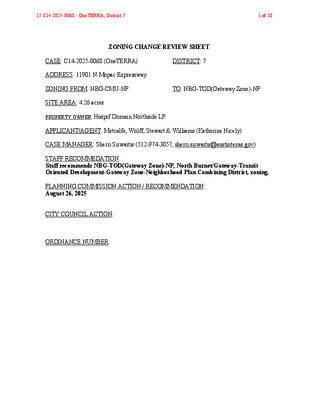
ZONING CHANGE REVIEW SHEET CASE: C14-2025-0068 (OneTERRA) DISTRICT: 7 ADDRESS: 11901 N Mopac Expressway ZONING FROM: NBG-CMU-NP TO: NBG-TOD(Gateway Zone)-NP SITE AREA: 4.26 acres PROPERTY OWNER: Husprf Domain Northside LP APPLICANT/AGENT: Metcalfe, Wolff, Stewart & Williams (Katherine Nicely) CASE MANAGER: Sherri Sirwaitis (512-974-3057, sherri.sirwaitis@austintexas.gov) STAFF RECOMMEDATION: Staff recommends NBG-TOD(Gateway Zone)-NP, North Burnet/Gateway-Transit Oriented Development-Gateway Zone-Neighborhood Plan Combining District, zoning. PLANNING COMMISSION ACTION / RECOMMENDATION: August 26, 2025 CITY COUNCIL ACTION: ORDINANCE NUMBER: 12 C14-2025-0068 - OneTERRA; District 71 of 18 ISSUES: N/A CASE MANAGER COMMENTS: The property in question is a 4.26 acre (185,346 sq. ft.) lot that is developed with a hotel/motel use. To the north is the frontage road for MoPac Expressway. The lot to the east is developed with a four-story office building with an associated parking garage zoned NBG- TOD-Gateway-NP. The Domain mixed use development, zoned MI-PDA, is located to the south and west across Gault Lane. In this case, the applicant is requesting a rezoning to the Transit Oriented Development-Gateway Zone subdistrict designation (NBG-TOD-Gateway Zone) (please see Applicant's Request Letter - Exhibit C). The staff’s recommendation is to grant the North Burnet/Gateway-Transit Oriented Development-Gateway Zone-Neighborhood Plan (NBG-TOD-NP) Combining District zoning for this property. The TOD-Gateway Zone Subdistrict is consistent with the current subdistrict zoning designation to the east and would permit this lot to be redeveloped with the highest density in the NBG (please see Figure 4-1 TOD: NBG Zoning District General Site Development Standards – Exhibit E). It will encourage a mixture of uses and more density at this location to achieve the vision of the North Burnet/Gateway Regulating Plan. This property is near a proposed Capital Metro rail station along the Red Line, the Broadmoor Station, which officials held a groundbreaking ceremony in January of 2022 on the property fronting Burnet Road known as the Uptown ATX campus. The station is being built to improve access to The Domain, a major high-density business, retail, and residential center. Construction on the project is expected to be completed in 2027. The applicant agrees with the staff’s recommendation. BASIS OF RECOMMENDATION: 1. The proposed zoning should be consistent with the purpose statement of the district sought. North Burnet/Gateway district is the designation for an identified area of existing low density, auto-oriented commercial, warehouse, and industrial uses that is the subject of an approved master plan for redevelopment of the area into a higher density urban mixed-use neighborhood that is more pedestrian friendly and takes advantage of the links to commuter rail transit and the area’s key position in the urban core. Transit oriented development subdistrict is the most intensively developed land use zone and will typically be expressed as high density residential or office over active ground floor uses, such as retail. This land use designation is concentrated near the Capital Metro commuter rail station. 12 C14-2025-0068 - OneTERRA; District 72 of 18 2. The proposed zoning should promote consistency and orderly planning. The NBG-TOD-Gateway Zone will permit this property to be redeveloped with the highest density in the NBG area. The purpose of the NBG-TOD subdistrict is to have the greatest focus on providing active pedestrian oriented uses at the ground level of buildings. The degree of development intensity permitted in the North Burnet/Gateway regulating plan is intended to be at the highest density in this TOD-Gateway Zone subdistrict and to step down away from the TOD station site to a lesser degree throughout the rest of the NBG area. The transit-oriented development subdistrict is the most intensively developed land use zone and will typically be expressed as high density residential or office over active ground floor uses, such as retail. The location of the site is appropriate for the proposed mixture and intensity of uses because the property in question is at the northeast intersection of a level 4/arterial roadway and a level 3/minor arterial roadway, directly to the north of The Domain development. The proposed subdistrict will increase intensity and density of a mix of land uses in the urban core near the city’s only operational rail line. EXISTING ZONING AND LAND USES: ZONING LAND USES Site NBG-CMU-NP North NBG-TOD-NP South MI-PDA East West NBG-TOD-NP ROW Hotel/Motel (La Quinta) Office, Parking Garage The Domain Retail Center (Whole Foods Market, Parking Garage) Detention Pond, Office North MoPac Expressway NEIGHBORHOOD PLANNING AREA: North Burnet/Gateway NP NEIGHBORHOOD ORGANIZATIONS: Austin Independent School District, Austin Neighborhoods Council, Friends of Austin Neighborhoods, Homeless Neighborhood Association SCHOOLS: Austin Independent School District 12 C14-2025-0068 - OneTERRA; District 73 of 18 REQUEST COMMISSION AREA CASE HISTORIES: NUMBER C14-2024-0139 (Rezoning for 11501 Burnet Road - City Initiated) NBG-TOD (Gateway Zone)- NP to NBG-TOD (Gateway Zone)- NP, to change a condition of zoning 11/12/24: Approved staff's recommendation of NBG-TOD (Gateway Zone)-NP zoning, to change a condition of zoning to remove conditions in the current zoning ordinance that state: A. The maximum height of a building or structure on the Property located within 200 feet of the Neighborhood Residential (NR) subdistrict shall be limited to 120 feet. B. The Property shall be developed according to the Commercial Mixed Use (CMU) subdistrict regulations, unless a Capital Metropolitan Transportation Authority (Cap Metro) Commuter Rail Station is proposed arid construction commenced. Upon issuance to the contractor of a notice to proceed for the construction of a Cap Metro Commuter Rail Station on or adjacent to the Property, the Property may be developed in compliance with transit-oriented development (TOD) Gateway zoning subdistrict regulations, by consent (12-0; G. Cox-absent); A. Azhar-1st, D. Skidmore-2nd. 9/24/24: Approved staff's recommendation of NBG-NMU- NP zoning by consent (10-0, P. Howard, N. Barrera-Ramirez and F. Maxwell-absent); R. Johnson-1st, A. Woods-2nd. CITY COUNCIL 12/12/24: Approved NBG- TOD(Gateway Zone)-NP zoning, to change a condition of zoning, by consent on all 3 readings (11-0); Z. Qadri- 1st, N. - Harper- Madison-2nd. 10/24/24: The public hearing was conducted and a motion to close the public hearing and approve Ordinance No. 20241024-076 for North Burnet/(Gateway- neighborhood plan (NBG-NP) combining district (neighborhood mixed use subdistrict) zoning was approved on Council Member Velasquez’s motion, Council Member Harper-Madison's second on an 11-0 vote. NBG-NR-NP to NBG-NMU-NP C14-2024-0090 (11700 Metric: 11550 and 11550 1/2 Metric Boulevard) 12 C14-2025-0068 - OneTERRA; District 74 of 18 C14-2024-0005 (2700 Gracy Farms: 2700 Gracy Farms Lane and 2700 ½ Gracy Farms Lane) C14-2021-0173 (11911 Burnet Road) NBG-NR-NP to NBG-CMU- Midway(CMU- M)-NP 8/13/2024: Approved staff's recommendation of NBG- CMU-M-NP zoning by consent (12-0, P. Howard-absent); A. Azhar-1st, A. Woods-2nd. 9/12/2024: Approved staff's recommendation of NBG- CMU-M-NP zoning by consent on all 3 readings (11-0); J. Vela-1st, P. Ellis-2nd. NBG-NR-NP to NBG-CMU-NP 12/22/21: Approved staff's recommendation of NBG- CMU-NP zoning by consent (8-0); C. Hempel-1st, P. Howard-2nd. 1/27/22: The public hearing was conducted and a motion to close the public hearing and approve Ordinance No. 20220127-082 for NBG-NP combining district (commercial mixed use subdistrict) zoning was approved on Council Member Kitchen's motion, Council Member Fuentes' second on an 11-0 vote. 4/12/18: Approved NBG-TOD- NP zoning, with conditions, on 1st reading only (6-0, G. Casar- off dais, D. Garza, E. Troxclair, K. Tovo and S. Adler-absent); L. Pool-1st, P. Renteria-2nd. 6/28/18: Ordinance No. 20180628-088 for north burnet/gateway-transit oriented development-gateway zone- neighborhood plan (NBG- TOD(Gateway Zone)-NP) combining district zoning, with conditions was approved on Council Member Troxclair’s motion, Council Member Garza’s second on an 11-0 vote. 8/28/14: Approved NBG-CO- NP zoning, with conditions, on consent on all 3 readings (7-0); B. Spelman-1st, L. Morrison- 2nd. 11/10/11: Approved NBG- CMU-NP zoning with conditions on consent on 1st reading only (7-0); Spelman-1st, M. Martinez-2nd. C14-2016-0136 (Broadmoor: 11501 Burnet Road) NBG-CMU-NP to NBG-TOD (Gateway Zone)-NP 3/27/18: Approved staff’s recommendation of NBG- TOD(Gateway)-NP zoning, with conditions, by consent (12-0, P. Seeger- absent); G. Anderson- 1st, J. Thompson-2nd. NBG-TOD-NP to NBG-CMU- NP NBG-TOD to NBG-CMU C14-2014-0058 (Esperanza Crossing: 2800 Esperanza Crossing) C14-2011-0050 (Burnet- Kramer Rezoning: 11205 & 11301 Burnet Road) 8/12/14: Approved staff’s recommendation of NBG- CMU-CO-NP zoning, with conditions, on consent (8-0, B. Roark-absent); S. Oliver-1st, N. Zaragoza-2nd. 10/11/11: Approved the staff’s recommendation of NBG- CMU-NP zoning for Tract 2, with the TIA conditions, by consent (9-0); M. Dealey-1st, D. Chimenti-2nd. 12 C14-2025-0068 - OneTERRA; District 75 of 18 zoning, 12/08/11: Approved NBG- CMU-NP with conditions, on consent on 2nd/3rd readings (6-0); C. Riley- 1st, S. Cole-2nd. RELATED CASES: C14-2007-0157 (North Burnet/Gateway NP Rezonings) OTHER STAFF COMMENTS: Comprehensive Planning The subject property located at 11901 North MoPac is currently developed as a hotel use on a 4-acre site. The zoning request appears to be consistent with the intent of the North Burnet Gateway Master Plan as well as urban planning and design best practices primarily by increasing intensity and density of a mix of land uses in the urban core near the city’s only operational rail line. NBG Master Plan: “1. Provide zoning entitlements that allow high density housing developments in the North Burnet/Gateway area (see “Land Use and Zoning” section of this chapter), to increase the supply of housing in Austin and begin to accommodate some of the housing demand that will be generated from expected population growth in the region. 2. Encourage high density housing in close proximity to transit to help reduce vehicle dependency.” p94 NBG MP ‘Housing’ “1f. Provide for a variety of housing options and affordability, so that people of all income levels can live and work in the area. Encourage housing to be developed in close proximity to potential jobsites as well as public transit so that residents may reduce their dependency on personal vehicles and save on transportation costs.” p64 Master Plan Goals “2a. Create more compact, denser development clustered in activity centers to encourage a greater percentage of travel accomplished by walking, biking, and transit.” p64 Master Plan Goals NBG Regulating Plan: “General Intent 1.1.6. To allow for and encourage significant higher density residential uses to accommodate some of the region’s expected population growth;” p13 NBG RP Environmental The site is located over the Edwards Aquifer Recharge Verification Zone. The site is in the Walnut Creek Watershed of the Colorado River Basin, which is classified as a Suburban 12 C14-2025-0068 - OneTERRA; District 76 of 18 Watershed by Chapter 25-8 of the City's Land Development Code. The site is in the Desired Development Zone. Under current watershed regulations, development or redevelopment on this site will be subject to the following impervious cover limits: Development Classification % of Gross Site Area % of Gross Site Area Single-Family (minimum lot size 5750 sq. ft.) Other Single-Family or Duplex Multifamily Commercial 50% 55% 60% 80% with Transfers 60% 60% 70% 90% According to floodplain maps there is no floodplain within or adjacent to the project location. Standard landscaping and tree protection will be required in accordance with LDC 25-2 and 25-8 for all development and/or redevelopment. At this time, site specific information is unavailable regarding vegetation, areas of steep slope, or other environmental features such as bluffs, springs, canyon rimrock, caves, sinkholes, and wetlands. Under current watershed regulations, development or redevelopment requires water quality control with increased capture volume and control of the 2-year storm on site. At this time, no information has been provided as to whether this property has any preexisting approvals that preempt current water quality or Code requirements. Fire No comments. Parks and Recreation Parkland dedication will be required at the time of subdivision or site plan application for new residential units, per City Code § 25-1-601, as amended. Whether the requirement shall be met with fees in-lieu or dedicated land will be determined using the criteria in City Code Title 25, Article 14, as amended. Should fees in-lieu be required, those fees shall be used toward park investments in the form of land acquisition and/or park amenities within the surrounding area, per the Parkland Dedication Operating Procedures § 14.3.11 and City Code § 25-1-609, as amended. Note that residential units that are certified affordable and income-restricted are exempt from the parkland dedication requirements per City Code § 25-1-601(D)(4). 12 C14-2025-0068 - OneTERRA; District 77 of 18 If the applicant wishes to discuss parkland dedication requirements in advance of site plan or subdivision applications, please contact this reviewer: ann.desanctis@austintexas.gov. At the applicant’s request, PARD can provide an early determination of whether fees in-lieu of land will be allowed. Site Plan Site plans will be required for any new development except for residential only project with up to 4 units. Any new development is subject to Subchapter E. Design Standards and Mixed Use. Additional comments will be made when the site plan is submitted. Transportation The existing TA for this site (associated with SP-2022-0403C) has been amended and a new memo is issued. A TIA compliance memo will be required at the site plan stage. Please see Exhibit F. The Austin Strategic Mobility Plan (ASMP) calls for 116 feet of right-of-way for Alterra Pkwy. It is recommended that 58 feet of right-of-way from the existing centerline should be dedicated for Alterra Pkwy according to the Transportation Plan with the first subdivision or site plan application. [LDC 25-6-51 and 25-6-55]. The Austin Strategic Mobility Plan (ASMP) calls for 116 feet of right-of-way for Gault Lane. It is recommended that 58 feet of right-of-way from the existing centerline should be dedicated for Gault Lane according to the Transportation Plan with the first subdivision or site plan application. [LDC 25-6-51 and 25-6-55]. The adjacent street characteristics table is provided below: Name ASMP Classification ASMP Required ROW Existing ROW Existing Pavement Sidewalks Bicycle Route Capital Metro (within ¼ mile) Alterra Parkway (Private Road) Gault Lane (Private Road) Level 3 116 feet Private Rd Private Rd None None No Level 3 116 feet Private Rd Private Rd None None No 12 C14-2025-0068 - OneTERRA; District 78 of 18 N Mopac Service Road Level 4 TxDOT Road TxDOT Road TxDOT Road Yes Yes No (TxDOT Road) Water Utility No comments on zoning change. FYI: The landowner intends to serve the site with existing City of Austin water utilities. Depending on the development plans submitted, water and or wastewater service extension requests may be required. All water and wastewater construction must be inspected by the City of Austin. For more information pertaining to the Service Extension Request process and submittal requirements contact the Austin Water SER team at ser@austintexas.gov. INDEX OF EXHIBITS TO FOLLOW A: Zoning Map B. Aerial Map C. Applicant’s Request Letter D. North Burnet/Gateway Regulating Plan Zoning Subdistrict Map E. TOD: NBG Zoning District General Site Development Standards F. TIA Compliance Memo 12 C14-2025-0068 - OneTERRA; District 79 of 18 EXHIBIT A MF-3 RR 81-165 82-214 85-244 GR SP-93-0147C SP-93-0251C UNDEV SP-85-176 79-098 P 95-0103 C14-95-0103 RR GR-CO SP96-0334C MF-2 UNDEV 85-244 85-244 85-244 82-214 MF-3 92-0090 SP-92-0013C MI-PDA C14-97-0017 P A L M W A Y T O M O P A C N B R A M P ! ! ! ! ! ! ! ! ! ! ! ! ! ! N M O P A C E X P Y S V R D N B ! ! ! ! ! SP-95-0009C ! ! ! ! ! ! ! ! ! ! NBG-NP ! ! 62-214 C14-2008-0182 ! ! ! ! ! ! ! RZ86-048 SP-0013C SP96-0024C SP-99-2160C W A L N U T C R E E K T R I B U T A R Y N M O P A C E X P Y S V R D S B N M O P A C N M O P A C E X P Y S B D U V A L R D N M O P A C E X P Y N B S V R D N B A T D U V A L T R N OFFICE BLDG. NBG-NP G R A C Y F A R M S L N SP-92-0461C 92-0064 NBG-NP NPA-2023-0024.01 G A U LT L N 75-127 C14-2021-0173 C 27 3 P-01-0 S C14-2010-0036 C14-06-0154 C14-2010-0087 ELECTRONICS MANUFACTURER SP-2007-0499D ! ! ! ! ! 85-149 ! ! ! ! ! ! ! ! ! ! ! ! JO H N S C H C14-2008-0182 SP89-0226C ASE TRL ! NBG-TOD-NP ! ! ! ! ! ! A Z U L X I N G OFFICE BLDG. ! ! ! ! ! ! ! ! ! ! ! D T R E N R U B ! ! ! ! ! ! ! ! ! ! ! ! ! ! NBG-TOD-NP C14-2016-0136 C14-2007-0157 ! ! ! ! ! ! ! ! ! ! ! ! ! ! ! ! ! ! ! ! ! ! 03-0017 C14-03-0017 C14-06-0121(RCA) 00-2065 C14-2007-0171 C14-2012-0002 C14-2020-0154 C14-2010-0015 C14-2010-0087(RCA) C14-2013-0130 PALM WAY C14-2015-0038 E V A E S O R K C O R 75-127 D O M A I N B L V D SP89-0227BS Y W K P A R R E T L A C14-2021-0191 SP89-0227BS SP-06-0369D 2007-0171 C14-2021-0191 C14-2022-0157 MI-PDA R D N I A M O D ± 1 " = 400 ' SUBJECT TRACT ! ! ! ! ! ! PENDING CASE ZONING BOUNDARY ZONING ! ! ! ZONING CASE#: C14-2025-0068 ! ! ! ! ! This product is for informational purposes and may not have been prepared for or be suitable for legal, engineering, or surveying purposes. It does not represent an on-the-ground survey and represents only the approximate relative location of property boundaries. ! ! ! ! This product has been produced by the Planning Department for the sole purpose of geographic reference. No warranty is made by the City of Austin regarding specific accuracy or completeness. ! ! ! ! ! ! ! ! ! ! ! ! ! ! ! ! ! ! ! ! ! ! ! ! ! ! ! ! ! ! ! ! Created: 6/9/2025 ! ! ! ! ! ! ! ! ! ! ! ! ! ! ! ! ! ! ! ! 12 C14-2025-0068 - OneTERRA; District 710 of 18 EXHIBIT B !!!!!!!!!!!!!!!!!!!!!!!!!!!!!!!!!!!!!!!!!!!!!!!!!!!!!!!!!!!!!!!!!!!!!!!!!!!!!!!C14-2025-0068C14-03-0017C14-2012-0002C14-2010-0015C14-2007-0171C14-06-0121(RCA)C14-2010-0087(RCA)C14-2015-0038C14-2013-0130C14-2008-0182C14-2016-0136C14-2008-0182C14-06-0154C14-97-0017C14-2020-0154C14-2010-0087C14-2010-0036NPA-2023-0024.01C14-2022-0157C14-2021-0173C14-95-0103C14-2021-0191C14-2021-0191BURNETRDDUVALRDPALMWAYGAULTLNNMOPACEXPYSBNMOPACEXPYNBDOMAINDRNMOPACEXPYSVRDSBNMOPACEXPYSVRDNBROCKROSEAVEDOMAINBLVDALTERRAPKWYAZULXINGPALMWAYTOMOPACNBRAMPJOHNSCHASETRLNMOPACSVRDNBATDUVALTRNMI-PDAMF-2MF-3PGRNBG-NPMF-3NBG-TOD-NPNBG-NPMI-PDAGR-CORRRRNBG-NPNBG-TOD-NPOneTERRA±This product has been produced by Planning Department for the sole purpose of geographic reference. No warranty ismade by the City of Austin regarding specific accuracy or completeness.ZONING CASE#:LOCATION:SUBJECT AREA:MANAGER:C14-2025-006811901 N Mopac Expy Svrd NB4.26 AcresSherri SirwaitisCreated: 7/8/2025SUBJECT TRACTZONING BOUNDARY!!!!!PENDING CASECREEK BUFFER1 inch equals 400 '12 C14-2025-0068 - OneTERRA; District 711 of 18 EXHIBIT C KATHERINE A. NICELY Senior Land Use & Development Planner knicely@mwswtexas.com 512-404-2248 Via Online Submittal May 23, 2025 Mrs. Lauren Middleton-Pratt, Director of Planning Housing and Planning Department 1000 East 11th Street Austin, Texas 78702 Re: Application for Rezoning; 4.26 acres, located at 11901 N Mopac Expressway (the “Property”) Dear Mrs. Middleton-Pratt: As representatives of the owner of the above stated Property we respectfully submit the attached Application for Rezoning. The Property currently has a hotel use and is currently zoned North Burnet-Gateway - Neighborhood Plan - Commercial Mixed-Use (NBG-NP-CMU) (see Zoning Exhibit attached). The Application for Rezoning requests to rezone the Property to North Burnet-Gateway - Neighborhood Plan - Transit - Oriented Development - Gateway Zone (NBG- NP-TOD Gateway Zone) to allow for a mix use development. The Property is located within the North Burnet Gateway Planning Area and it is designated as High Density Mixed Use; there is no request to amend the Future Land Use as designated by the Neighborhood plan. The property to the East is zoned as is within the North Burnet Gateway Planning Area and the property to the south is within zoned Major Industry - Planned Development Area (MI-PDA). A Traffic Impact Analysis (TIA) has been previously completed for this site. The updated TDW represents a change to TOD-Gateway zoning and the existing TIA will be amended, and a new memo will be issued at zoning. If you have any questions about this Application for Rezoning or need additional information, please do not hesitate to contact me at your convenience. Thank you for your time and attention to this project. Very truly yours, Katherine A. Nicely 221 W. 6th Street, Suite 1300, Austin, TX 78701 • 512.404.2200 • fax 512.404.2245 • www.mwswtexas.com 12 C14-2025-0068 - OneTERRA; District 712 of 18 D U V A L R D ZONING EXHIBIT N M O P A C E X P Y 12 C14-2025-0068 - OneTERRA; District 713 of 18 >?/?(6 (,/(cid:14)9!:;(cid:31)7*"(cid:31)8*7(cid:14)’ (cid:30)(cid:31) !"#(cid:14)$(cid:14)%(cid:14)&(cid:14)’(cid:14)()"*+(cid:14),!"-#*(cid:14).(cid:14)/0*#102(cid:14)3(,/4(cid:14)5)-(cid:31)- (cid:14)6(cid:31)7*"(cid:31)8*(cid:14)9!:;(cid:31)7*"(cid:31)8*(cid:14)<0=(cid:14) @"0-7(cid:31)*(cid:14)%(cid:14)A"(cid:31)#-*#;(cid:14)6#B#C)=D#-*(cid:14) 3@A6(cid:14).(cid:14)@A6(cid:14)<(cid:31);1024 F=;0*#;(cid:14)M&.$N.&M&O (cid:9)(cid:13)(cid:7)(cid:12)(cid:10) (cid:27) (cid:0)(cid:2)(cid:3)(cid:4)(cid:5) (cid:19) (cid:7) (cid:4) (cid:16) (cid:4) (cid:10) (cid:21) (cid:7) (cid:27) (cid:18) (cid:13) (cid:9) (cid:29) (cid:7) (cid:2) (cid:6) (cid:22) (cid:5)(cid:15) (cid:5) (cid:15) (cid:9)(cid:20) (cid:29) (cid:13)(cid:15) (cid:18) @A6(cid:14)%(cid:14)/0*#102(cid:14)5)-# I)DD#"8(cid:31)0C(cid:14)<(cid:31)E#;(cid:14)%(cid:14)F7#(cid:14)3I<F4 I<F(cid:14)%(cid:14)<(cid:31);102(cid:14)5)-# I<F(cid:14)%(cid:14)/0*#102(cid:14)5)-# (#(cid:31) +:)"+));(cid:14)<(cid:31)E#;(cid:14)F7#(cid:14)3(<F4 (#(cid:31) +:)"+));(cid:14)G#7(cid:31);#-*(cid:31)0C(cid:14)3(G4 H0"#+)!7#(cid:14)<(cid:31)E#;(cid:14)F7#(cid:14)3H<F4 I)DD#"8(cid:31)0C(cid:14)J-;!7*"(cid:31)0C(cid:14)3IJ4 G#7#0"8+(cid:14)0-;(cid:14)98(cid:31)#-8#7(cid:14)<(cid:31)E#;(cid:14)F7#(cid:14)3G9<F4 L8*(cid:31)B#(cid:14)?; #7 (,/(cid:14)KC0--(cid:31)- (cid:14)L"#0(cid:14),)!-;0"2 K0"8#C(cid:14),)!-;0"2 G0(cid:31)C")0;7 (cid:18) (cid:13) (cid:15) (cid:29) (cid:9) (cid:5) (cid:4) (cid:8) (cid:9) (cid:8)(cid:7)(cid:4)(cid:27)(cid:9)(cid:7) (cid:10) (cid:4) (cid:11) (cid:28) (cid:15) (cid:26)(cid:27) (cid:14)(cid:23) (cid:11) (cid:15) (cid:15) (cid:5) (cid:6)(cid:7)(cid:4)(cid:8)(cid:9)(cid:7) (cid:19)(cid:7)(cid:9) (cid:4)(cid:13)(cid:14)(cid:20)(cid:12)(cid:5)(cid:5)(cid:18) (cid:10)(cid:4)(cid:11)(cid:12)(cid:13)(cid:4)(cid:5)(cid:14)(cid:15)(cid:16)(cid:14)(cid:13)(cid:9)(cid:17)(cid:4)(cid:18) (cid:21)(cid:15)(cid:7)(cid:8) (cid:13)(cid:2)(cid:0)(cid:15)(cid:7) (cid:20) (cid:22) (cid:21) (cid:14) (cid:23) (cid:24) (cid:25) (cid:14) (cid:26) (cid:7) (cid:9) (cid:18) (cid:9) (cid:4) (cid:7) (cid:10) (cid:20) F@(cid:14)K(cid:31)8PC#(cid:14) G#7#0"8+(cid:14)I0D=!7 (cid:5)(cid:15)(cid:29)(cid:19)(cid:20)(cid:15)(cid:7)(cid:29) (cid:12)(cid:29)(cid:0)(cid:2)(cid:18)(cid:13)(cid:7)(cid:12)(cid:4)(cid:5) (cid:29) (cid:15) (cid:18) (cid:11) (cid:27) (cid:15) (cid:20) (cid:14)(cid:13) (cid:12)(cid:5)(cid:18) (cid:9) (cid:29) (cid:27)(cid:10)(cid:20)(cid:4)(cid:5)(cid:9) (cid:7) (cid:2) (cid:29) (cid:0) (cid:6) (cid:9) (cid:7) (cid:19) (cid:7)(cid:2)(cid:13)(cid:5)(cid:4)(cid:29)(cid:0) (cid:12)(cid:13)(cid:9)(cid:0) (cid:29) (cid:2) (cid:12)(cid:10) (cid:7) (cid:13) (cid:9) (cid:27) (cid:0)(cid:15)(cid:29)(cid:5)(cid:9)(cid:21) (cid:0)(cid:9)(cid:29)(cid:13)(cid:15)(cid:29) (cid:9)(cid:29)(cid:9)(cid:7)(cid:19)(cid:21) (cid:7)(cid:9)(cid:12)(cid:0) (cid:9)(cid:12)(cid:5) (cid:28)(cid:29) (cid:10) (cid:27) 12 C14-2025-0068 - OneTERRA; District 714 of 18 FIGURE 4 - 1 TOD : NBG ZONING DISTRICT GENERAL SITE DEVELOPMENT STANDARDS TRANSIT ORIENTED DEVELOPMENT (TOD) SUBDISTRICT EXHIBIT E Revised 10-25-23 LOT SIZE FLOOR TO AREA RATIO BUILDING HEIGHT Minimum Lot Size 2,500 SF Minimum Lot Width 20 Feet MINIMUM SETBACKS Front Yard and Street Side Yard*: No ground-level front yard or street side yard setbacks are required. Instead, development must meet the building placement standards in Section 4.3. Interior Side Yard: Rear Yard: 0 Feet 0 Feet * If the street right-of-way is less than 60 feet in width, the minimum front yard and street side yard setbacks for build- ings three or more stories in height shall be 30 feet from the center line of the re access. MAXIMUM IMPERVIOUS COVER If located in an urban watershed (Shoal or Little Walnut Creek) : Established on Figure 4-6 (Based on the maximum impervious cover allowed by the property’s zoning prior to adoption of the this Document.) Maximum Floor-to-Area Ratio (FAR) by Right: Established on Figure 4-2 (Based on the maximum FAR allowed by the prop- erty’s zoning prior to adoption of this Document) Maximum Floor-to-Area Ratio (FAR) with Development Bonus: TOD Gateway Zone TOD Midway Zone 12:1 12:1 is FAR may be granted in exchange for e de- velopment bonus criteria and standards are detailed in Article 6. Minimum Building Height: 2 Stories Maximum Building Height by Right: Established on Figure 4-4 (Based on the maximum height allowed by the prop- erty’s zoning prior to adoption of this Document.) Maximum Building Height with Development Bonus* TOD Gateway TOD Midway 491 Feet 491 Feet is building height may be granted in exchange for the provision of public e development bonus crite- ria and standards are detailed in Article 6. Typical example of buildings in the Transit Oriented Development Subdistrict. 491’ Max. Height with Development Bonus (TOD Gateway & TOD Midway) If located in a suburban watershed (Walnut Creek)*: * vious cover requirements of Section 25-8-394(C) of the LDC. is requirement supersedes imper- 80% 5 Stories 12 C14-2025-0068 - OneTERRA; District 715 of 18 EXHIBIT F MEMORANDUM Date: To: CC: Reference: August 04, 2025 Kelly Rees, P.E., Kimley-Horn Renee Johns, Mustafa Wali, Transportation & Public Works Department (TPW) Hines Domain Tower (SP-2022-0403C/ C14-2025-0068)- 11901 North Mopac Expressway Transportation Assessment (TA) Final Memo Summary of the Transportation Assessment (TA): Figure 1: Site Location The Transportation and Public Works Department has reviewed the May 19, 2023, submittal of the “Hines Domain Tower TA”, prepared by Kimley-Horn for the site, as depicted in Figure 1. The TIA has been amended, and the new proposal includes 608,000 square feet of general office space and 4,500 square feet of coffee/donut shop without a drive-through. This represents an increase of 58,000 square feet in office space. The proposed project will provide access to the surrounding roadway network via three access points. Visitors and staff will be able to enter the site through two full access driveways, one located on Alterra Parkway and the other on a private drive along the north-east side of the site where it intersects Domain Point Driveway. Private drive refers to the street segment on the east side of the project site, connecting Gault Lane and N Mopac Service Road. Another full access driveway will be available on Private Drive along the east side of the site, but this will serve as a service entrance only. The proposed development will be built in one phase and is anticipated to be completed in 2027. As a transportation condition of approval for the above-referenced site plan application, the applicant shall comply with the following recommendations: 1. The proposed development is subject to the City of Austin Street Impact Fee (Ordinance # 20201220-061 & 20201210-062). Instead of constructing the identified improvements in the TA, the developer has chosen to pay the Street Impact Fee (SIF) as per City of Austin guidelines. The SIF will be calculated and Page 1 of 3 12 C14-2025-0068 - OneTERRA; District 716 of 18 invoiced for this development at the time of building permit and will satisfy the mitigation requirements of this site. No building permit shall be issued until the required SIF collection amount is paid in full. 2. Development of this property should not vary from the approved uses or deviate from the approved intensities and estimated traffic generation assumptions within the finalized TA document, including land uses, trip generation, trip distribution, traffic controls, driveway locations, and other identified conditions. Any change in the assumptions made to the TA document shall be reviewed by TPW and may require a new or updated TA/TIA/addendum. 3. Approval of this TA does not grant nor guarantee approval of proposed driveway locations. Driveways will be further reviewed during site plan review by the appropriate City departments. 4. The findings and recommendations of this TA memorandum remain valid until five (5) years from the date of the traffic counts in the TA or the date of this memo, whichever comes first, after which a revised TA/TIA or addendum may be required. Assumptions: • An annual growth rate of 4% was assumed. Trip Generation and Land Use: Based on the Institute of Transportation Engineers (ITE) Trip Generation Manual (11th Edition), the development will generate approximately 4,337 daily trips with 1,022 trips being generated during the AM peak hour (between 7am and 9am), and 717 trips being generated during the PM peak hour (4pm-6pm), details are shown in Table 1. Table 1: Trip Generation Summary of Identified Improvements: The TA has identified the following mitigations to improve vehicular operations within the study area: • Alterra Parkway & Driveway 1 (To be constructed by the developer) o Construct westbound driveway with two outbounds lanes • Private Drive & Domain Point Driveway/Driveway 2 o Construct eastbound driveway with two outbound lanes (To be constructed by the developer) o Convert to all-way stop-control • Alterra Parkway & Domain Drive/Gault Lane o Re-stripe southbound right+thru lane to right only lane o Construct westbound left turn lane (~280’) • Private Drive & Gault Lane o Construct westbound right turn lane (130’ turn bay + 50’ taper) • Burnet Road/Duval Road & Gault Lane Page 2 of 3 12 C14-2025-0068 - OneTERRA; District 717 of 18 o Adjust signal timings (approval required from TPW) o Construct southbound right turn lane (130’ turn bay + 50’ taper) o Construct westbound left turn lane (200’ turn bay + 50’ taper) o Construct westbound right turn lane (130’ turn bay + 50’ taper) • Alterra Parkway & Mopac NB Service Road o Restripe eastbound right+thru lane to right only lane o Adjust the channelization of the northbound right-turn lane to allow for free northbound right turns • Private Drive & Mopac NB Service Road o Restripe eastbound right+thru lane to right only lane o Adjust the channelization of the northbound right-turn lane to allow for free northbound right turns The total of cost of the improvements is approximately $84,479. However, the developer has chosen to pay the Street Impact Fee as per City of Austin guidelines instead of constructing/funding any of the identified improvements in the TA. The SIF will be calculated and invoiced for this development at the time of building permit and will satisfy the mitigation requirements of this site. Transportation Demand Management The applicant has committed to attaining at least a 10% TDM reduction to meet certain vehicle trip reduction targets. In the TDM plan, the applicant has identified several measures that could be incorporated with the site to achieve the targeted vehicle trip reduction. The applicant identified the following key measures to reach the reduction target: Internal Capture Reduction (5%) • • Visitor Parking Pricing (1%) • Designated Mobility Coordinator, Marketing & Information, and Delivery-Supportive Amenities (1%) • Pedestrian Access and Connectivity (1%) • Bicycle Access and Connectivity (1%) • Emerging Mobility Access and Connectivity (1%) • Site Plan Access and Connectivity (1%) A Sustainable Mode Analysis was conducted as part of TDM plan and deficiencies were found in terms of missing sidewalks, crosswalks, non-compliant ramps, non-compliant pedestrian push buttons, and protected bike lanes. Please contact me at (512) 978-1671 if you have questions or require additional information. Sincerely, Austin Jones, P.E. Transportation & Public Works Department, City of Austin Page 3 of 3 12 C14-2025-0068 - OneTERRA; District 718 of 18