02 NPA-2022-0010.02 - 2000 E. 6th Street and 2007 E. 7th Street; District 3 - Staff Report — original pdf
Backup
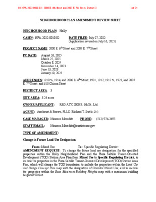
NEIGHBORHOOD PLAN AMENDMENT REVIEW SHEET NEIGHORHOOD PLAN: Holly CASE#: NPA-2022-0010.02 DATE FILED: July 27, 2022 (Application revised on July 16, 2025) PROJECT NAME: 2000 E. 6th Street and 2007 E. 7th Street PC DATE: August 26, 2025 March 25, 2025 October 8, 2024 November 14, 2023 June 13, 2023 January 10, 2023 ADDRESS/ES: 1910 ½, 1914, and 2000 E. 6th Street; 1901, 1917, 1917 ½, 1923, and 2007 E. 7th Street; and 613 Chicon Street DISTRICT AREA: 3 SITE AREA: 3.24 acres OWNER/APPLICANT: REG ATX 2000 E. 6th St., Ltd. AGENT: Armbrust & Brown, PLLC (Richard T. Suttle, Jr.) CASE MANAGER: Maureen Meredith PHONE: (512) 974-2695 STAFF EMAIL: Maureen.Meredith@austintexas.gov TYPE OF AMENDMENT: Change in Future Land Use Designation From: Mixed Use To: Specific Regulating District AMENDMENT REQUEST: To change the future land use designation for the specified properties within the Holly Neighborhood Plan and the Plaza Saltillo Transit-Oriented Development (TOD) Station Area Plan from Mixed Use to Specific Regulating District; to include the properties in the Plaza Saltillo Transit-Oriented Development (TOD) Station Area Plan, which will change the TOD boundaries; to include the properties within the Land Use and Design Concept Plan map with the designation of Corridor Mixed Use; and to include the properties within the Base Maximum Building Heights map with a maximum building height of 90 feet. 02 NPA-2022-0010.02 - 2000 E. 6th Street and 2007 E. 7th Street; District 31 of 24 Base District Zoning Change Related Zoning Case: C14-2025-0036 From: CS-MU-CO-NP and TOD-NP To: TOD-NP NEIGHBORHOOD PLAN ADOPTION DATE: December 13, 2001 CITY COUNCIL DATE: TBD ACTION: PLANNING COMMISSION RECOMMENDATION: August 26, 2025 – Action pending March 25, 2025 – Indefinitely postponed on the consent agenda at the request of the Applicant. [A. Azhar – 1st; F. Maxwell – 2nd] Vote: 11-0. October 8, 2024 – Indefinitely postponed on the consent agenda at the request of the Applicant. [G. Anderson – 1st; A. Woods – 2nd] Vote: 10-0 [G. Cox, J. Mushtaler, and A. Phillips off the dais]. November 14, 2023 –Indefinitely postponed on the consent agenda at the request of the Applicant. [A. Azhar – 1st; F. Maxwell – 2nd] Vote: 12-0 [N. Barrera-Ramirez off the dais]. June 13, 2023 - Indefinitely postponed on the consent agenda at the request of the Applicant. [A. Woods – 1st; A. Ahar – 2nd] Vote: 11-0 [C. Hempel absent. One vacancy on the dais]. January 10, 2023 – Indefinitely postponed on the consent agenda at the request of the Applicant. [A. Azhar – 1st: J. Thompson – 2nd] Vote: 11-0 [P. Howard absent. One vacancy on the dais]. STAFF RECOMMENDATION: Staff supports the applicant’s request to change the future land use designation for the specified properties within the Holly Neighborhood Plan and the Plaza Saltillo Transit-Oriented Development (TOD) Station Area Plan from Mixed Use to Specific Regulating District; to include the properties in the Plaza Saltillo Transit- Oriented Development (TOD) Station Area Plan, which will change the TOD boundaries; to include the properties within the Land Use and Design Concept Plan map with the designation of Corridor Mixed Use; and to include the properties within the Base Maximum Building Heights map with a maximum building height of 90 feet. BASIS FOR STAFF’S RECOMMENDATION: Staff supports the applicant’s request because the property is within Plaza Saltillo Neighborhood Activity Center, and is located on E. 7th Street, which is an activity corridor where mixed use developments are encouraged. 02 NPA-2022-0010.02 - 2000 E. 6th Street and 2007 E. 7th Street; District 32 of 24 The property is near the Plaza Saltillo Rail Station and near multiple bus routes. The applicant proposes a mixed-use development to include approximately 500 multifamily residential units with approximately 5,000 sf of commercial uses. The location near the rail station and public transit will help meet the density needed to maintain and expand the public transportation system. The property will provide neighborhood-serving commercial uses and also provide much-needed residential units for the City. LAND USE DESCRIPTIONS: EXISTING LAND USE: Mixed Use - An area that is appropriate for a mix of residential and non‐residential uses. Purpose 1. Encourage more retail and commercial services within walking distance of residents; 2. Allow live‐work/flex space on existing commercially zoned land in the neighborhood; 3. Allow a mixture of complementary land use types, which may include housing, retail, offices, commercial services, and civic uses (with the exception of government offices) to encourage linking of trips; 4. Create viable development opportunities for underused center city sites; 5. Encourage the transition from non‐residential to residential uses; 6. Provide flexibility in land use standards to anticipate changes in the marketplace; 7. Create additional opportunities for the development of residential uses and affordable housing; and 8. Provide on‐street activity in commercial areas after 5 p.m. and built‐in customers for local businesses. Application 1. Allow mixed use development along major corridors and intersections; 2. Establish compatible mixed‐use corridors along the neighborhood’s edge 3. The neighborhood plan may further specify either the desired intensity of commercial uses (i.e. LR, GR, CS) or specific types of mixed use (i.e. Neighborhood Mixed Use Building, Neighborhood Urban Center, Mixed Use Combining District); 02 NPA-2022-0010.02 - 2000 E. 6th Street and 2007 E. 7th Street; District 33 of 24 4. Mixed Use is generally not compatible with industrial development, however it may be combined with these uses to encourage an area to transition to a more complementary mix of development types; 5. The Mixed Use (MU) Combining District should be applied to existing residential uses to avoid creating or maintaining a non‐conforming use; and 6. Apply to areas where vertical mixed use development is encouraged such as Core Transit Corridors (CTC) and Future Core Transit Corridors. PROPOSED LAND USE: Specific Regulating District - This map designation is intended for areas that have an adopted regulating plan. This district will be identified on the Future Land Use Map, but is not considered a typical land use category. The purpose of this designation is to make the user aware of the Regulating Plan and that it should be reviewed for development regulations. Approved Regulating Plans: 1. Plaza Saltillo TOD Station Area Plan 2. Martin Luther King (MLK) Boulevard TOD Station Area Plan 3. Lamar/Justin TOD Station Area Plan Yes Yes Imagine Austin Decision Guidelines Complete Community Measures Imagine Austin Growth Concept Map: Located within or adjacent to an Imagine Austin Activity Center, Imagine Austin Activity Corridor, or Imagine Austin Job Center as identified the Growth Concept Map. Name(s) of Activity Center/Activity Corridor/Job Center: • The property is located within the Plaza Saltillo Neighborhood Center • The property has frontage on E. 7th Street, which is an activity corridor. Yes Mobility and Public Transit: Located within 0.25 miles of public transit stop and/or light rail station. • 0.4 miles from the Plaza Saltillo Station • Bus routes along E. 7th Street and Chicon Street Yes Mobility and Bike/Ped Access: Adjoins a public sidewalk, shared path, and/or bike lane. Yes Connectivity, Good and Services, Employment: Provides or is located within 0.50 miles to goods and services, and/or employment center. Yes Connectivity and Food Access: Provides or is located within 0.50 miles of a grocery store/farmers market. • 0.2 miles from Radius Butcher & Grocery • 0.3 miles from Royal Blue Grocery Yes Connectivity and Education: Located within 0.50 miles from a public school or university. • 0.3 miles from Zavala Elementary School 02 NPA-2022-0010.02 - 2000 E. 6th Street and 2007 E. 7th Street; District 34 of 24 • 0.3 miles of The University of Texas at Austin Elementary School Yes Connectivity and Healthy Living: Provides or is located within 0.50 miles from a recreation area, park or walking trail. • 0.4 miles from Pan American Neighborhood Park Yes Connectivity and Health: Provides or is located within 0.50 miles of health facility (ex: hospital, urgent care, doctor’s office, drugstore clinic, and/or specialized outpatient care.) • 0.1 miles from Zamora Medical Center • 0.2 miles from Planned Parenthood Yes Housing Affordability: Provides a minimum of 10% of units for workforce housing (80% MFI or less) and/or fee in lieu for affordable housing. • The applicant will comply with the affordable housing program outlined in the TOD. The exact number is unknown at this time. Yes Housing Choice: Expands the number of units and housing choice that suits a variety of household sizes, incomes, and lifestyle needs of a diverse population (ex: apartments, triplex, granny flat, live/work units, cottage homes, and townhomes) in support of Imagine Austin and the Strategic Housing Blueprint. • Applicant is proposing approx. 500 multifamily residential units Yes Mixed use: Provides a mix of residential and non-industrial uses. • Applicant states the development will be a mixed-use development to include 500 MF dwelling units and approx. 5000 sf of commercial uses. No Culture and Creative Economy: Provides or is located within 0.50 miles of a cultural resource (ex: library, theater, museum, cultural center). • 1.1 miles from Terrazas Public Library Not known Not known Not known No 11 Culture and Historic Preservation: Preserves or enhances a historically and/or culturally significant site. Creative Economy: Expands Austin’s creative economy (ex: live music venue, art studio, film, digital, theater.) Workforce Development, the Economy and Education: Expands the economic base by creating permanent jobs, especially in industries that are currently not represented in particular area or that promotes a new technology, and/or promotes educational opportunities and workforce development training. Industrial Land: Preserves or enhances industrial land. Number of “Yeses” 02 NPA-2022-0010.02 - 2000 E. 6th Street and 2007 E. 7th Street; District 35 of 24 Proximity to Imagine Austin Activity Centers and Corridors 02 NPA-2022-0010.02 - 2000 E. 6th Street and 2007 E. 7th Street; District 36 of 24 Proximity to Public Parks 02 NPA-2022-0010.02 - 2000 E. 6th Street and 2007 E. 7th Street; District 37 of 24 Proximity to Public Transportation IMAGINE AUSTIN GROWTH CONCEPT MAP Definitions Neighborhood Centers - The smallest and least intense of the three mixed-use centers are neighborhood centers. As with the regional and town centers, neighborhood centers are walkable, bikable, and supported by transit. The greatest density of people and activities in neighborhood centers will likely be concentrated on several blocks or around one or two intersections. However, depending on localized conditions, different neighborhood centers can be very different places. If a neighborhood center is designated on an existing commercial area, such as a shopping center or mall, it could represent redevelopment or the addition of housing. A new neighborhood center may be focused on a dense, mixed-use core surrounded by a mix of housing. In other instances, new or redevelopment may occur incrementally and concentrate people and activities along several blocks or around one or two intersections. Neighborhood centers will be more locally focused than either a regional or a town center. Businesses and services—grocery and department stores, doctors and dentists, shops, branch libraries, dry cleaners, hair salons, schools, restaurants, and other small and local businesses—will generally serve the center and surrounding neighborhoods. 02 NPA-2022-0010.02 - 2000 E. 6th Street and 2007 E. 7th Street; District 38 of 24 Town Centers - Although less intense than regional centers, town centers are also where many people will live and work. Town centers will have large and small employers, although fewer than in regional centers. These employers will have regional customer and employee bases, and provide goods and services for the center as well as the surrounding areas. The buildings found in a town center will range in size from one-to three-story houses, duplexes, townhouses, and rowhouses, to low-to midrise apartments, mixed use buildings, and office buildings. These centers will also be important hubs in the transit system. Regional Centers - Regional centers are the most urban places in the region. These centers are and will become the retail, cultural, recreational, and entertainment destinations for Central Texas. These are the places where the greatest density of people and jobs and the tallest buildings in the region will be located. Housing in regional centers will mostly consist of low to high-rise apartments, mixed use buildings, row houses, and townhouses. However, other housing types, such as single-family units, may be included depending on the location and character of the center. The densities, buildings heights, and overall character of a center will depend on its location. Activity Centers for Redevelopment in Sensitive Environmental Areas - Five centers are located over the recharge or contributing zones of the Barton Springs Zone of the Edwards Aquifer or within water-supply watersheds. These centers are located on already developed areas and, in some instances, provide opportunities to address long-standing water quality issues and provide walkable areas in and near existing neighborhoods. State-of-the-art development practices will be required of any redevelopment to improve stormwater retention and the water quality flowing into the aquifer or other drinking water sources. These centers should also be carefully evaluated to fit within their infrastructural and environmental context. Job Centers - Job centers accommodate those businesses not well-suited for residential or environmentally- sensitive areas. These centers take advantage of existing transportation infrastructure such as arterial roadways, freeways, or the Austin-Bergstrom International airport. Job centers will mostly contain office parks, manufacturing, warehouses, logistics, and other businesses with similar demands and operating characteristics. They should nevertheless become more pedestrian and bicycle friendly, in part by better accommodating services for the people who work in those centers. While many of these centers are currently best served by car, the growth Concept map offers transportation choices such as light rail and bus rapid transit to increase commuter options. Corridors - Activity corridors have a dual nature. They are the connections that link activity centers and other key destinations to one another and allow people to travel throughout the city and region by bicycle, transit, or automobile. Corridors are also characterized by a variety of activities and types of buildings located along the roadway — shopping, restaurants and cafés, parks, schools, single-family houses, apartments, public buildings, houses of worship, mixed-use buildings, and offices. Along many corridors, there will be both large and small redevelopment sites. These redevelopment opportunities may be continuous along stretches of the corridor. There may also be a series of small neighborhood centers, connected by the roadway. Other corridors may have fewer redevelopment 02 NPA-2022-0010.02 - 2000 E. 6th Street and 2007 E. 7th Street; District 39 of 24 opportunities, but already have a mixture of uses, and could provide critical transportation connections. As a corridor evolves, sites that do not redevelop may transition from one use to another, such as a service station becoming a restaurant or a large retail space being divided into several storefronts. To improve mobility along an activity corridor, new and redevelopment should reduce per capita car use and increase walking, bicycling, and transit use. Intensity of land use should correspond to the availability of quality transit, public space, and walkable destinations. Site design should use building arrangement and open space to reduce walking distance to transit and destinations, achieve safety and comfort, and draw people outdoors. BACKGROUND: The applicant proposes to change the future land use designation for the specified properties within the Holly Neighborhood Plan and the Plaza Saltillo Transit- Oriented Development (TOD) Station Area Plan from Mixed Use to Specific Regulating District; to include the properties in the Plaza Saltillo Transit-Oriented Development (TOD) Station Area Plan, which will change the TOD boundaries; to include the properties within the Land Use and Design Concept Plan map with the designation of Corridor Mixed Use; and to include the properties within the Base Maximum Building Heights map with a maximum building height of 90 feet. There is a portion of the property that is outside of the Plaza Saltillo TOD boundaries which will be developed with properties that are within the boundaries. The applicant wants to develop the properties together with one unified development standards. The applicant proposes approximately 500 residential dwelling units and approximately 5,000 sf of commercial uses. For more information on the proposed zoning case, see case report for C14-2025-0036. PUBLIC MEETINGS: The ordinance-required community meeting was virtually held on June 17, 2025. The recorded meeting can be found here: https://publicinput.com/neighborhoodplanamendmentcases. Approximately 4,138 meeting notices were mailed to people with utility accounts or own property within the Plaza Saltillo 02 NPA-2022-0010.02 - 2000 E. 6th Street and 2007 E. 7th Street; District 310 of 24 TOD Station Area Plan boundaries and the notice was mailed to people who live within the 500-foot notification boundary of the area. Also notified were neighborhood and environmental group who requested notification for the area. Two city staff members attended the meeting from the Planning Department, Maureen Meredith and Mark Walters, in addition to the applicant’s agents, Richard T. Suttle, Jr., Kelly Wright and Amanda Morrow from Armbrust and Brown, PLLC and Josh Lickteig from Endeavor Real Estate Group. No one from the neighborhood attended. Below are highlights from Richard T. Suttle’s presentation: • We want to bring all the properties into the TOD and increase the building height to a maximum of 90 feet across the site to allow for the development of a mixed-use project. 02 NPA-2022-0010.02 - 2000 E. 6th Street and 2007 E. 7th Street; District 311 of 24 Applicant Summary Letter from Application 02 NPA-2022-0010.02 - 2000 E. 6th Street and 2007 E. 7th Street; District 312 of 24 02 NPA-2022-0010.02 - 2000 E. 6th Street and 2007 E. 7th Street; District 313 of 24 02 NPA-2022-0010.02 - 2000 E. 6th Street and 2007 E. 7th Street; District 314 of 24 02 NPA-2022-0010.02 - 2000 E. 6th Street and 2007 E. 7th Street; District 315 of 24 Letter of Recommendation from the Neighborhood Plan Contact Team (NPCT) There is no Holly Neighborhood Plan Contact Team 02 NPA-2022-0010.02 - 2000 E. 6th Street and 2007 E. 7th Street; District 316 of 24 Site 02 NPA-2022-0010.02 - 2000 E. 6th Street and 2007 E. 7th Street; District 317 of 24 02 NPA-2022-0010.02 - 2000 E. 6th Street and 2007 E. 7th Street; District 318 of 24 02 NPA-2022-0010.02 - 2000 E. 6th Street and 2007 E. 7th Street; District 319 of 24 02 NPA-2022-0010.02 - 2000 E. 6th Street and 2007 E. 7th Street; District 320 of 24 02 NPA-2022-0010.02 - 2000 E. 6th Street and 2007 E. 7th Street; District 321 of 24 02 NPA-2022-0010.02 - 2000 E. 6th Street and 2007 E. 7th Street; District 322 of 24 Applicant’s Presentation at the Community Meeting No presentation was made. 02 NPA-2022-0010.02 - 2000 E. 6th Street and 2007 E. 7th Street; District 323 of 24 Correspondence Received No correspondence received. 02 NPA-2022-0010.02 - 2000 E. 6th Street and 2007 E. 7th Street; District 324 of 24