04 NPA-2024-0016.04 - Strandtman Cove; District 3 - Staff Report — original pdf
Backup
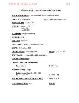
NEIGHBORHOOD PLAN AMENDMENT REVIEW SHEET NEIGHORHOOD PLAN: Govalle/Johnston Terrace Combined (Govalle) CASE#: NPA-2024-0016.04 DATE FILED: December 27, 2024 PROJECT NAME: Standtman Cove PC DATE: August 12, 2025 July 22, 2025 June 24, 2025 ADDRESS/ES: 20 Strandtman Cove DISTRICT AREA: 3 SITE AREA: 5.34 acres OWNER/APPLICANT: 20 Strandtman Cove AGENT: 20 Strandtman LLC CASE MANAGER: Maureen Meredith PHONE: (512) 974-2695 STAFF EMAIL: Maureen.Meredith@austintexas.gov TYPE OF AMENDMENT: Change in Future Land Use Designation From: Industry To: Mixed Use Base District Zoning Change Related Zoning Case: C14-2025-0004 From: LI-CO-NP To: LI-PDA-NP NEIGHBORHOOD PLAN ADOPTION DATE: March 27, 2003 CITY COUNCIL DATE: TBD ACTION: 04 NPA-2024-0016.04 - Strandtman Cove; District 31 of 23 PLANNING COMMISSION RECOMMENDATION: August 12, 2025 – (action pending) July 22, 2025 – Postponed on the consent agenda to August 12, 2025 at the request of Staff. June 24, 2025 – Postponed on the consent agenda to July 22, 2025 at the Applicant’s request. [G. Anderson – 1st; F. Maxwell – 2nd] Vote: 9-0 [A. Powell off the dais. A. Azhar, C. Haney and D. Skidmore absent]. STAFF RECOMMENDATION: Staff supports the Applicant’s request for Mixed Use land use. BASIS FOR STAFF’S RECOMMENDATION: The property is located near three activity corridors, E. Cesar Chavez Street, E. 7th Street and Airport Blvd and appears to have been a building supplies company. There is Mixed Use land use on the north side of E. Cesar Chavez Street, which is directly north of the subject tract, and Mixed Use land use is to the east and west of the property. Mixed Use land use is appropriate in this location. The applicant proposed a multifamily development with 945 dwelling units. The proposed development will provide additional housing choices for the City and the planning area. 04 NPA-2024-0016.04 - Strandtman Cove; District 32 of 23 LAND USE DESCRIPTIONS: EXISTING LAND USE: Industry- Areas reserved for manufacturing and related uses that provide employment but are generally not compatible with other areas with lower intensity use. Industry includes general warehousing, manufacturing, research and development, and storage of hazardous materials. Purpose 1. To confine potentially hazardous or nuisance‐creating activities to defined districts; 2. To preserve areas within the city to increase employment opportunities and increased tax base; 3. To protect the City’s strategic advantage as a high tech job center; and 4. To promote manufacturing and distribution activities in areas with access to major transportation systems. Application 1. Make non‐industrial properties in areas with a dominant industrial character compatible with the prevailing land use scheme; 2. Where needed, require a buffer area for industrial property that abuts residentially used land; 3. Industry should be applied to areas that are not appropriate for residential or mixed use development, such as land within the Airport Overlay; 4. In general, mixed use and permanent residential activities are not appropriate in industrial areas. An exception may be the edge of an industrial area along the interface with an area in which residential activities are appropriate. Such exceptions should be considered case by case, with careful attention to both land use compatibility and design; 5. Industry should not be either adjacent to or across the road from single family residential or schools; 6. Use roadways and/or commercial or office uses as a buffer between residential and industry; and 7. Smaller scale “local manufacturing” districts may be appropriate in some locations to preserve employment opportunities and cottage industries of local artisans. In these areas, hazardous industrial uses (i.e. basic industry, recycling centers, and scrap yards) should be prohibited. 04 NPA-2024-0016.04 - Strandtman Cove; District 33 of 23 PROPOSED LAND USE: Mixed Use - An area that is appropriate for a mix of residential and non‐residential uses. Purpose 1. Encourage more retail and commercial services within walking distance of residents; 2. Allow live‐work/flex space on existing commercially zoned land in the neighborhood; 3. Allow a mixture of complementary land use types, which may include housing, retail, offices, commercial services, and civic uses (with the exception of government offices) to encourage linking of trips; 4. Create viable development opportunities for underused center city sites; 5. Encourage the transition from non‐residential to residential uses; 6. Provide flexibility in land use standards to anticipate changes in the marketplace; 7. Create additional opportunities for the development of residential uses and affordable housing; and 8. Provide on‐street activity in commercial areas after 5 p.m. and built‐in customers for local businesses. Application 1. Allow mixed use development along major corridors and intersections; 2. Establish compatible mixed‐use corridors along the neighborhood’s edge 3. The neighborhood plan may further specify either the desired intensity of commercial uses (i.e. LR, GR, CS) or specific types of mixed use (i.e. Neighborhood Mixed Use Building, Neighborhood Urban Center, Mixed Use Combining District); 4. Mixed Use is generally not compatible with industrial development, however it may be combined with these uses to encourage an area to transition to a more complementary mix of development types; 5. The Mixed Use (MU) Combining District should be applied to existing residential uses to avoid creating or maintaining a non‐conforming use; and 6. Apply to areas where vertical mixed use development is encouraged such as Core Transit Corridors (CTC) and Future Core Transit Corridors. 04 NPA-2024-0016.04 - Strandtman Cove; District 34 of 23 Yes Yes Imagine Austin Decision Guidelines Complete Community Measures Imagine Austin Growth Concept Map: Located within or adjacent to an Imagine Austin Activity Center, Imagine Austin Activity Corridor, or Imagine Austin Job Center as identified the Growth Concept Map. Name(s) of Activity Center/Activity Corridor/Job Center: • Near three activity corridors: Airport Blvd, E. 7th Street and East Cesar Chavez St. Yes Mobility and Public Transit: Located within 0.25 miles of public transit stop and/or light rail station. No Mobility and Bike/Ped Access: Adjoins a public sidewalk, shared path, and/or bike lane. Yes Connectivity, Good and Services, Employment: Provides or is located within 0.50 miles No to goods and services, and/or employment center. Connectivity and Food Access: Provides or is located within 0.50 miles of a grocery store/farmers market. • 1.6 miles from HEB No Connectivity and Education: Located within 0.50 miles from a public school or university. • 1.2 miles from Brooke Elem. Yes Connectivity and Healthy Living: Provides or is located within 0.50 miles from a recreation area, park or walking trail. • Colorado River Wildlife Park directly to the south of the property No Connectivity and Health: Provides or is located within 0.50 miles of health facility (ex: hospital, urgent care, doctor’s office, drugstore clinic, and/or specialized outpatient care.) Yes Housing Affordability: Provides a minimum of 10% of units for workforce housing (80% MFI or less) and/or fee in lieu for affordable housing. • Applicant states affordable dwelling units will be provided through a private restrictive covenant. Yes Housing Choice: Expands the number of units and housing choice that suits a variety of household sizes, incomes, and lifestyle needs of a diverse population (ex: apartments, triplex, granny flat, live/work units, cottage homes, and townhomes) in support of Imagine Austin and the Strategic Housing Blueprint. • Applicant is proposing 945 multifamily residential units. No Mixed use: Provides a mix of residential and non-industrial uses. No Culture and Creative Economy: Provides or is located within 0.50 miles of a cultural resource (ex: library, theater, museum, cultural center). Culture and Historic Preservation: Preserves or enhances a historically and/or culturally significant site. Creative Economy: Expands Austin’s creative economy (ex: live music venue, art studio, film, digital, theater.) Workforce Development, the Economy and Education: Expands the economic base by creating permanent jobs, especially in industries that are currently not represented in particular area or that promotes a new technology, and/or promotes educational opportunities and workforce development training. Industrial Land: Preserves or enhances industrial land. Number of “Yeses” No Not known Not known No 6 04 NPA-2024-0016.04 - Strandtman Cove; District 35 of 23 Proximity to Imagine Austin Activity Centers and Corridors 04 NPA-2024-0016.04 - Strandtman Cove; District 36 of 23 Proximity to Public Transportation 04 NPA-2024-0016.04 - Strandtman Cove; District 37 of 23 Proximity to Public Parks IMAGINE AUSTIN GROWTH CONCEPT MAP Definitions Neighborhood Centers - The smallest and least intense of the three mixed-use centers are neighborhood centers. As with the regional and town centers, neighborhood centers are walkable, bikable, and supported by transit. The greatest density of people and activities in neighborhood centers will likely be concentrated on several blocks or around one or two intersections. However, depending on localized conditions, different neighborhood centers can be very different places. If a neighborhood center is designated on an existing commercial area, such as a shopping center or mall, it could represent redevelopment or the addition of housing. A new neighborhood center may be focused on a dense, mixed-use core surrounded by a mix of housing. In other instances, new or redevelopment may occur incrementally and concentrate people and activities along several blocks or around one or two intersections. Neighborhood centers will be more locally focused than either a regional or a town center. Businesses and services—grocery and department stores, doctors and dentists, shops, branch libraries, dry cleaners, hair salons, schools, restaurants, and other small and local businesses—will generally serve the center and surrounding neighborhoods. Town Centers - Although less intense than regional centers, town centers are also where many people will live and work. Town centers will have large and small employers, although 04 NPA-2024-0016.04 - Strandtman Cove; District 38 of 23 fewer than in regional centers. These employers will have regional customer and employee bases, and provide goods and services for the center as well as the surrounding areas. The buildings found in a town center will range in size from one-to three-story houses, duplexes, townhouses, and rowhouses, to low-to midrise apartments, mixed use buildings, and office buildings. These centers will also be important hubs in the transit system. Regional Centers - Regional centers are the most urban places in the region. These centers are and will become the retail, cultural, recreational, and entertainment destinations for Central Texas. These are the places where the greatest density of people and jobs and the tallest buildings in the region will be located. Housing in regional centers will mostly consist of low to high-rise apartments, mixed use buildings, row houses, and townhouses. However, other housing types, such as single-family units, may be included depending on the location and character of the center. The densities, buildings heights, and overall character of a center will depend on its location. Activity Centers for Redevelopment in Sensitive Environmental Areas - Five centers are located over the recharge or contributing zones of the Barton Springs Zone of the Edwards Aquifer or within water-supply watersheds. These centers are located on already developed areas and, in some instances, provide opportunities to address long-standing water quality issues and provide walkable areas in and near existing neighborhoods. State-of-the-art development practices will be required of any redevelopment to improve stormwater retention and the water quality flowing into the aquifer or other drinking water sources. These centers should also be carefully evaluated to fit within their infrastructural and environmental context. Job Centers - Job centers accommodate those businesses not well-suited for residential or environmentally- sensitive areas. These centers take advantage of existing transportation infrastructure such as arterial roadways, freeways, or the Austin-Bergstrom International airport. Job centers will mostly contain office parks, manufacturing, warehouses, logistics, and other businesses with similar demands and operating characteristics. They should nevertheless become more pedestrian and bicycle friendly, in part by better accommodating services for the people who work in those centers. While many of these centers are currently best served by car, the growth Concept map offers transportation choices such as light rail and bus rapid transit to increase commuter options. Corridors - Activity corridors have a dual nature. They are the connections that link activity centers and other key destinations to one another and allow people to travel throughout the city and region by bicycle, transit, or automobile. Corridors are also characterized by a variety of activities and types of buildings located along the roadway — shopping, restaurants and cafés, parks, schools, single-family houses, apartments, public buildings, houses of worship, mixed-use buildings, and offices. Along many corridors, there will be both large and small redevelopment sites. These redevelopment opportunities may be continuous along stretches of the corridor. There may also be a series of small neighborhood centers, connected by the roadway. Other corridors may have fewer redevelopment opportunities, but already have a mixture of uses, and could provide critical transportation connections. As a corridor evolves, sites that do not redevelop may transition from one use to 04 NPA-2024-0016.04 - Strandtman Cove; District 39 of 23 another, such as a service station becoming a restaurant or a large retail space being divided into several storefronts. To improve mobility along an activity corridor, new and redevelopment should reduce per capita car use and increase walking, bicycling, and transit use. Intensity of land use should correspond to the availability of quality transit, public space, and walkable destinations. Site design should use building arrangement and open space to reduce walking distance to transit and destinations, achieve safety and comfort, and draw people outdoors. BACKGROUND: The applicant proposes to change the future land use map from Industry to Mixed Use land us. The applicant proposes to change the zoning on the property from LI-CO-NP (Limited Industrial district – Conditional Overlay combining district – Neighborhood Plan TO LI- PDA-NP (Limited Industrial district – Planned Development Area combining district – Neighborhood Plan) to build approximately 945 multifamily dwelling units. The applicant states affordable housing units will be provided through a private restrictive covenant. For more information on the proposed zoning, see case report C14-2025-0004. PUBLIC MEETINGS: The ordinance-required community meeting was virtually held on February 24, 2025. The recorded meeting can be found here: https://publicinput.com/neighborhoodplanamendmentcases. Approximately 49 meeting notices were mailed to people who have utility accounts and own property within 500 feet of the subject property. Two city staff members from the Planning Department attended the meeting, Maureen Meredith and Mark Walters. Alice Glasco, the applicant’s agent attended along with the property owner, Reza Paydar. Three people from the neighborhood attended. Below are highlights from Alice Glasco’s presentation: • It’s approximately 5.34 acres. We are proposing a rezoning to LI-PDA-NP. We propose to prohibit some industrial uses. • The PDA will allow for residential uses. We proposed 945 residential units in a 10 to 11-story building. • We are asking for a building height of 120 feet. • We have a Transportation Analysis Study submitted to the Transportation Dept. Q: Will the property retain the light industrial zoning? A: The LI will be combined with the PDA, which is similar to the Borden tract next door to allow a mixed-use development. There will a recommendation to remove the industrial uses. The PDA allows you to increase building height, FAR, and site development regulations. The Mixed Use combining district doesn’t allow you to do that. Q: The area is close to the nature preserve. Is there going to be accommodations to that sensitive area? A: We met with the Parks Department because there is a trail we are trying to connect from the Borden tract, but this will be addressed during the site plan stage. There is a drainage 04 NPA-2024-0016.04 - Strandtman Cove; District 310 of 23 easement on the bottom half of the property. We will share with the neighborhood what we find out. Q: Is this going to be absorbed into the Borden Development? A: This will be a separate development. Q: How long has Mr. Paydar owned the property? A: About eight years. 04 NPA-2024-0016.04 - Strandtman Cove; District 311 of 23 Applicant Summary Letter from Application 04 NPA-2024-0016.04 - Strandtman Cove; District 312 of 23 04 NPA-2024-0016.04 - Strandtman Cove; District 313 of 23 04 NPA-2024-0016.04 - Strandtman Cove; District 314 of 23 Letter of Recommendation from the Neighborhood Plan Contact Team (NPCT) From: Daniel Llanes < > Sent: Tuesday, July 29, 2025 12:22 PM To: Meredith, Maureen <Maureen.Meredith@austintexas.gov> Cc: Tomko, Jonathan <Jonathan.Tomko@austintexas.gov>; Alice Glasco <Candi Fox < > Subject: Re: G/JT NPCT Rec: NPA-2025-0016.04_20 Strandtman Cv Importance: High Hi Maureen, We have been in contact with Alice Glasco and will be meeting with her and her client this coming Thursday for a second time. Afterwards Candice Fox, our chair will send you our formal position. Thanks, Daniel …………. On Jul 29, 2025, at 12:02 PM, Meredith, Maureen <Maureen.Meredith@austintexas.gov> wrote: Dear Govalle/Johnston Terrace Cmnd NPCT: NPA-2024-0016.04 and C14-2025-0004_20 Strandtman Cove cases are on the August 12th PC hearing. We are anticipating the cases will be ready for PC action on this date. If your team would like to have a letter of recommendation included in our staff case reports, please email it to me and Jonathan, the zoning planner, by 5:00 pm on Wednesday, August 6, 2025 which is when our staff reports are due. Also, please let me and Jonathan know if your team has been meeting with Alice since my virtual community meeting on February 24, 2025 (https://publicinput.com/i43388) and if any agreement has been made that staff should be aware of. Thanks. Maureen 04 NPA-2024-0016.04 - Strandtman Cove; District 315 of 23 Site 04 NPA-2024-0016.04 - Strandtman Cove; District 316 of 23 04 NPA-2024-0016.04 - Strandtman Cove; District 317 of 23 04 NPA-2024-0016.04 - Strandtman Cove; District 318 of 23 04 NPA-2024-0016.04 - Strandtman Cove; District 319 of 23 04 NPA-2024-0016.04 - Strandtman Cove; District 320 of 23 04 NPA-2024-0016.04 - Strandtman Cove; District 321 of 23 Alice Glasco’s Presentation at the Community Meeting (No formal presentation made) 04 NPA-2024-0016.04 - Strandtman Cove; District 322 of 23 Correspondence Received 04 NPA-2024-0016.04 - Strandtman Cove; District 323 of 23