05 C14-2025-0004 - Strandtman Cove; District 3 - Staff Report — original pdf
Backup
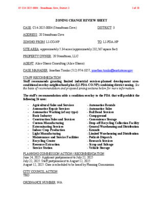
ZONING CHANGE REVIEW SHEET CASE: C14-2025-0004 (Strandtman Cove) DISTRICT: 3 ADDRESS: 20 Strandtman Cove ZONING FROM: LI-CO-NP TO: LI-PDA-NP SITE AREA: approximately 5.34 acres (approximately 232,567 square feet) PROPERTY OWNER: 20 Strandtman, LLC AGENT: Alice Glasco Consulting (Alice Glasco) CASE MANAGER: Jonathan Tomko (512) 974-1057, jonathan.tomko@austintexas.gov STAFF RECOMMEDATION: Staff recommends granting limited industrial services-planned development area- conditional overlay-neighborhood plan (LI-PDA-CO-NP) combining district zoning. See the basis of recommendation and proposed zoning sections below for more information. The staff’s recommendation adds a condition overlay to the PDA that will prohibit the following 26 uses: - Agricultural Sales and Services - Automotive Repair Services - Automotive Washing (of any type) - Basic Industry - Construction Sales and Services - Custom Manufacturing - Exterminating Services - Indoor Crop Production - Light Manufacturing - Maintenance and Service Facilities - Recycling Center - Resource Extraction - Service Station - Automotive Rentals - Automotive Sales - Bail Bond Services - Campground - Convenience Storage - Drop-off Recycling Collection Facility - General Warehousing and Distribution - Kennels - Limited Warehousing and Distribution - Pedicab Dispatch - Research Services - Scrap and Salvage - Vehicle Storage PLANNING COMMISSION ACTION / RECOMMENDATION: June 24, 2025: Applicant postponement to July 22, 2025 July 22, 2025: Staff postponement to August 12, 2025 August 12, 2025: Case is scheduled to be heard by Planning Commission CITY COUNCIL ACTION: TBD ORDINANCE NUMBER: N/A 05 C14-2025-0004 - Strandtman Cove; District 31 of 20 ISSUES: N/A CASE MANAGER COMMENTS: The subject tract contains a medium sized warehouse currently utilized for foundation building materials. To the north, is one medium office, one auto repair garage, and undeveloped land. To the west, are eight medium sized warehouses (approximately 3,000 to 20,000 square feet each) comprising the Hull Door Supply Company and undeveloped land. To the south, is undeveloped land which fronts the Colorado River. To the east, is the old Borden Dairy which was recently rezoned to the same zoning being requested in this case. The proposed PDA development standards reasonably modify setbacks, building height, building coverage, and floor-to-area ratio (FAR) to create a relatively denser development that is consistent with rezonings that have been granted in the immediate area as formerly industrial sites are being redeveloped into multifamily housing and mixed-use developments. The proposed development will provide a denser development with both market rate and affordable housing proximate to the East Cesar Chavez Street and East 7th Street Imagine Austin Activity Corridors. Proposed Zoning Section 1. Applicable Site Development Regulations A. If there is a conflict between this Ordinance and applicable City of Austin rules, regulations and ordinances, this Ordinance including the Exhibits shall control. Section 2. Authorized Uses a. Except as provided in sections b and c below and the CO (conditional overlay), all permitted and conditional uses under LI, Limited Industrial Services, zoning are permitted and conditional uses for the subject property. b. The following uses are additional permitted uses: • Condominium residential • Group residential • Multifamily residential • Townhouse residential c. The following uses are prohibited uses: • Basic Industry • Recycling center • Resource extraction • General warehousing and distribution • Scrap and salvage Section 3. Site Development Regulations d. The following site development standards apply to the PDA property: • The maximum height is 120 feet - plus additional height allowed by Section 25-2-531 (Height Limit Exceptions) 05 C14-2025-0004 - Strandtman Cove; District 32 of 20 • The minimum front yard setback is 0 feet • The minimum street side yard setback is 0 feet • The minimum interior side yard setback is 0 feet • The minimum rear yard setback is 0 feet. • The maximum building coverage is 80% • The maximum impervious cover is 80% • The maximum floor-to-area ratio is 8:1 BASIS OF RECOMMENDATION: Zoning should allow for reasonable use of the property. The proposed PDA development standards reasonably modify setbacks, building height, building coverage, and floor-to-area ratio (FAR) to create a relatively denser development that is consistent with rezonings that have been granted in the immediate area as formerly industrial sites are being redeveloped into multifamily housing and mixed-use developments. Zoning should promote clearly-identified community goals such as creating employment opportunities or providing for affordable housing. The proposed development will provide a denser development with both market rate and affordable housing proximate to the East Cesar Chavez Street and East 7th Street Imagine Austin Activity Corridors. Zoning should promote the policy of located retail and more intensive zoning near the intersections of arterial roadways or at the intersections of arterials and major collectors/highways. The subject site is located at the nexus of multiple major roadways including US HWY 183/Airport Boulevard to the east as well as E. Cesar Chavez to the north where more dense development and intensive land uses should be located. EXISTING ZONING AND LAND USES: ZONING Site LI-CO-NP North LI-CO-NP South East West LI-PDA-NP, PNP, RR- NP, and GR-CO-NP LI-PDA-NP LI-CO-NP, GR-CO-NP, and RR-NP LAND USES Medium sized warehouse of approximately 18,000 square feet One medium office, one auto repair garage, and undeveloped land Undeveloped land Undeveloped land (recently rezoned through C14-2022- 0121 - see area case histories section below Eight medium sized warehouses (approximately 3,000 to 20,000 square feet each) and undeveloped land NEIGHBORHOOD PLANNING AREA: Govalle/Johnston Terrace (Govalle) WATERSHED: Colorado River Watershed SCHOOLS: A.I.S.D. - The required Educational Impact Statement is below as exhibit E. 05 C14-2025-0004 - Strandtman Cove; District 33 of 20 Govalle Elementary School Martin Middle School Eastside Early College High School COMMUNITY REGISTRY LIST: Austin Independent School District, Austin Neighborhoods Council, Del Valle Community Coalition, East Austin Conservancy, East Town Lake Citizens Neighborhood Association, El Concilio Mexican-American Neighborhoods, Friends of Austin Neighborhoods, Govalle/Johnston Terrace Neighborhood Plan Contact Team, Guadalupe Neighborhood Development Corporation, Homeless Neighborhood Association, Overton Family Committee, Preservation Austin, River Bluff Neighborhood Assoc., Tejano Town AREA CASE HISTORIES: NUMBER C14-2022-0121 (Borden Tract) REQUEST LI-CO-NP to LI- PDA-NP C14-2022-0054 (830 Airport 830 Airport, 838 Airport, 917 Shady Lane, 923 Shady Lane) C14-2020-0073 (MSC & CTC Tracts Zoning 748 Airport Boulevard) SF-3-NP & CS-CO- NP to CS-MU-V- CO-NP CS-CO-NP to CS- MU-V-NP C14-2018-0042 (Red Bluff Rezoning 4713 E. Cesar Chavez Street) CS-MU-CO-NP to CS-MU-CO-NP (remove a condition of zoning) COMMISSION To Grant LI-PDA- NP as recommended by Staff with additional conditions (3/28/2023) To Grant CS-MU-V- CO-NP as recommended by Staff, on Consent (7/26/2022) To Grant CS-MU-V- CO-NP as recommended by Staff, on Consent (12/22/2020) To Grant CS-MU- CO-NP as recommended by staff (9/25/2018) CITY COUNCIL Approved LI-PDA- NP as Commission recommended with additional conditions (7/20/2023) Approved CS-MU- V-CO-NP as Commission recommended (09/01/2022) Approved CS-MU- V-CO-NP as Commission Recommended (01/27/2021) Approved CS-MU- CO-NP as Commission recommended (10/18/2018) RELATED CASES: NPA-2024-0016.04 (Future Land Use Map – FLUM change from Industry to Mixed Use) ADDITIONAL STAFF COMMENTS: Environmental The site is not located over the Edwards Aquifer Recharge Zone. The site is located in 1. the Colorado River Watershed of the Colorado River Basin, which is classified as an Urban Watershed by Chapter 25-8 of the City's Land Development Code. It is in the Desired Development Zone. 2. Zoning district impervious cover limits apply in the Urban Watershed classification. 05 C14-2025-0004 - Strandtman Cove; District 34 of 20 3. According to floodplain maps there is a floodplain within or adjacent to the project location. Based upon the location of the floodplain, offsite drainage should be calculated to determine whether a Critical Water Quality Zone exists within the project location. 4. Standard landscaping and tree protection will be required in accordance with LDC 25-2 and 25-8 for all development and/or redevelopment. 5. At this time, site specific information is unavailable regarding vegetation, areas of steep slope, or other environmental features such as bluffs, springs, canyon rimrock, caves, sinkholes, and wetlands. 6. This site is required to provide on-site water quality controls (or payment in lieu of) for all development and/or redevelopment when 8,000 s.f. cumulative is exceeded, and on site control for the two-year storm. 7. At this time, no information has been provided as to whether this property has any preexisting approvals that preempt current water quality or Code requirements. Fire No comments on rezoning PARD – Planning & Design Review Parkland dedication will be required at the time of subdivision or site plan application for new residential units, per City Code § 25-1-601, as amended. The proposed development meets the criteria for land dedication in City Code Title 25, Article 14. Land dedication will be required, as well as any remaining fees in-lieu. This site contains a critical connection to parkland, and the potential to be part of a future greenbelt. Should there be any remaining fees in-lieu, those fees shall be used toward park investments in the form of land acquisition and/or park amenities within the surrounding area, per the Parkland Dedication Operating Procedures § 14.3.11 and City Code § 25-1- 609. Should the applicant wish to discuss parkland dedication requirements in advance of site plan or subdivision applications, please contact this reviewer: scott.grantham@austintexas.gov. At the applicant’s request, PARD can provide an early determination letter of the requirements as stated in this review. Site Plan SP1. Site plans will be required for any new development except for residential only projects with up to 4 units. SP2. Any new development is subject to LDC Subchapter E Design Standards and Mixed Use. Additional comments will be made when the site plan is submitted. 05 C14-2025-0004 - Strandtman Cove; District 35 of 20 SP3. This tract is already developed and the proposed zoning change is within the footprint of an existing development. SP4. The site is located within Austin-Bergstrom Overlay. No uses will be allowed that create electrical interference with navigational signals or radio communications between airport and aircraft, make it difficult for pilots to distinguish between the airport lights and others, result in glare in the eyes of pilots using the airport, impair visibility in the vicinity of the airport, create bird strike hazards or otherwise in any way endanger or interfere with the landing, taking off, or maneuvering of aircraft intending to use the Austin-Bergstrom Airport. Height limitations and incompatible uses with each Airport Overlay zone are established in the Airport Overlay Ordinance. Transportation and Public Works (TPW) Department – Engineering Review Zoning transportation analysis (ZTA) shall be performed at zoning where anticipated trips are anticipated to exceed 2,000 unadjusted trips to satisfy the LDC requirement for a TIA but does not diminish the authority to require a traffic impact analysis at site plan. The ZTA has been completed and is attached below as exhibit D. EXISTING STREET CHARACTERISTICS: Name ASMP Classification ASMP Required ROW Existing ROW Existing Pavement Sidewalks Bicycle Route Capital Metro (within ¼ mile) Strandtman CV Level 1 58’ Yes No Yes 163’ (diameter of dead end turn- around) 138’ (diameter of dead end turn- around) TIA: The ZTA has been completed and is attached below as exhibit D. Austin Water Utility AW1. No comments on zoning change. FYI: The landowner intends to serve the site with existing City of Austin water utilities. Depending on the development plans submitted, water and or wastewater service extension requests may be required. All water and wastewater construction must be inspected by the City of Austin. For more information pertaining to the Service Extension Request process and submittal requirements contact the Austin Water SER team at ser@austintexas.gov. INDEX OF EXHIBITS AND ATTACHMENTS TO FOLLOW: A. Zoning Map B. Aerial Map 05 C14-2025-0004 - Strandtman Cove; District 36 of 20 C. Applicant’s Summary Letter D. Zoning Transportation Analysis (ZTA) Final Memo E. Educational Impact Statement (EIS) 05 C14-2025-0004 - Strandtman Cove; District 37 of 20 GR-MU-CO-NP ( CS-MU-V-CO-NP C14-2020-0073 NPA-2020-0016.01 ( GR-MU-NP ( CS-CO-NP VACANT LOT SP-05-1426C 2008-0259.001 02-0093 C14-02-0093 CS-V-CO-NP NPA-2008-0016.01 C14-2007-0259 C14-2007-0259.001 NPA-2008-0016.02 SP97-0139C AUTOMOTIVE CS-MU-CO-NP P M A R R E D N VA E O L B T T S R O P AIR E 7 T H S T I A R P O R T B L V D P-NP DAIRY PLANT SP-89-93C L E V A N D E R L O O P J U LIE A N N A C V SP-00-2002C ! ! ! ! ! ! ! ! ! ! ! ! ! ! ! ! ! CS-MU-V-CO-NP ! C14-2017-0140 ! ! ! ! ! ! ! ! SPC-04-0014A LI-CO-NP ! ! ! C14-2007-0259 NPA-2008-0016.01 ! ! ! CS-CO-NP O . C S A L V A G E N Y L D A H S USE D SALES CS-MU-CO-NP NPA-2008-0016.01 CS-V-CO-NP C14-2007-0259 TELEPHONE CO CS-CO-NP SP96-0342C G. D L T B N A C A V E L E C T R O N I C C O M P . CS-CO-NP Y L P P U K S C U R T NPA-2009-0016.02 C14-2009-0083 CS-MU-CO-NP 2009-0083 E 5TH ST ! ! ! ! ! ! C14-2022-0103 LI-PDA-NP ! ! ! ! CS-CO-NP ! ! ! ! ! ! N R L E C N E P S ! LI-CO-NP ! ! ! M A C HIN E W R K S. O . Y C L P P U S C 7 33 6-0 9 P S ( ( SP83-345C EQUIPMENT YARD LI-CO-NP ! ! ! ! ! ! ! ! ! ! ! ! ! ! ! ! ! ! ! ! ! ! ! ! ! ! ! ! ! ! ! ! ! ! ! ! ! ! ! ! ! ! ! ! ! ! ! ! ! ! ! ! ! ! ! ! GR-CO-NP E H O R S T U A CS-MU-CO-NP S G A B A R CS-CO-NP A I R P P O F R E I G H T C O . O. C E C N A N E T AIN M P-NP L U M B E R L M I L SF-3-NP 73-162 MF-2-NP RED BLUFF RD 80-180 SF-3-NP 88-28 97-0063 ! ! ! ! RED BLUFF WATERFRONT OVERLAY COMBINING DISTRICT RR-NP C14-72-204 P-NP C14-97-0063 W H S E CS-CO-NP EXP IM P O RT O R ! ! T OXYEN CO. C14-2007-0259 NPA-2008-0016.01 CS-V-CO-NP ! ! ! ! P-NP ! ! ! S S A L G R E FIB Y N A P M O C N T I O C Y U L R P T P E F I C F O ! ! C RI T C E L E P. M O C ! ! ! ! ! ! ! ! LI-CO-NP ! ! ! ! O C S U N S ! ! ! ! ! ! ! ! ! ! AUTO SUPPLY ! ! ! ! ! ! CS-MU-V-CO-DB90-NP C14-2024-0037 ! ! ! ! ! ! ! ! ! ! ! ! ! ! ! ! !! E CESAR CHAVEZ ST V C N A M T D N A R T S ! ! ! ! ! ! ! ! ! ! ! ! ! ! ! ! GR-CO-NP ! ! ! ! ! ! GR-MU-CO-NP ! ! ! ! ! ! ! ! ! ! ! ! SP-99-2078C ! ! ! ! ! ! ! ! ! ! ! ! ! ! ! ! ! ! ! ! ! ! LI-PDA-NP NPA-2022-0016.02 C14-2022-0121 86-290 P-NP ± SUBJECT TRACT ! ! ! ! ! ! PENDING CASE ZONING BOUNDARY ZONING ZONING CASE#: C14-2025-0004 This product is for informational purposes and may not have been prepared for or be suitable for legal, engineering, or surveying purposes. It does not represent an on-the-ground survey and represents only the approximate relative location of property boundaries. 1 " = 400 ' This product has been produced by the Planning Department for the sole purpose of geographic reference. No warranty is made by the City of Austin regarding specific accuracy or completeness. Created: 1/14/2025 05 C14-2025-0004 - Strandtman Cove; District 38 of 20 05 C14-2025-0004 - Strandtman Cove; District 39 of 20 ALICE GLASCO CONSULTING December 19, 2024 Lauren Middleton-Pratt, Director Planning Department 6310 Wilhelmina Delco Drive Austin, Texas 78752 RE: 20 Strandtman Cove Dear Ms. Middleton-Pratt: I represent 20 Strandtman Cove, LLC, the owner of the subject property, in a request to rezone the property and amend the Future Land Use Map (FLUM) of the Govalle/Johnston Terrace Combined Neighborhood Plan. The current rezoning is LI-CO-NP, and the requested rezoning is LI-PDA-NP. The change to the FLUM is from Industry to Mixed Use. Current State: The subject site is used for foundation building materials. Govalle/Johnston Terrace Combined Neighborhood Plan: Land Use Goal # 3: Develop a balanced and varied pattern of land use. Key Principles: • Provide a balance of land use and zoning for people to both live and work in the area. • Encourage mixed use so that residential uses are allowed on some commercial properties. • Provide opportunities for land uses that serve the needs of daily life (live, work, play, shop). 05 C14-2025-0004 - Strandtman Cove; District 310 of 20 Proposed PDA Standards The proposed PDA standards for the subject property would be as follows: a. Except as provided in sections b and c below, all permitted and conditional uses under LI, Limited Industrial Services, zoning are permitted and conditional uses for the subject property. b. The following uses are additional permitted uses: • Condominium residential • Group residential • Multifamily residential • Townhouse residential c. The following uses are prohibited uses: • Basic Industry • Recycling center • Resource extraction • General warehousing and distribution • Scrap and salvage d. The following site development standards apply to the PDA property: • The maximum height is 120 feet - plus additional height allowed by Section 25-2-531 (Height Limit Exceptions) • The minimum front yard setback is 0 feet • The minimum street side yard setback is 0 feet • The minimum interior side yard setback is 0 feet • The minimum rear yard setback is 0 feet. • The maximum building coverage is 80% • The maximum impervious cover is 80% • The maximum floor-to-area ratio is 8:1 Justification for FLUM change and rezoning: • Redevelopment opportunity: the proposed rezoning will allow the site to be developed with housing. • Imagine Austin Comprehensive Plan Corridors: the site is in proximity to E. Cesar Chavez Street, and E. 7th Street, which are designated as Imagine Austin Corridors. • Proximity to transit: the site is within walking distancer to bus stops on E. Cesar Chavez Street and Shary Lane and E. 5th Street. 05 C14-2025-0004 - Strandtman Cove; District 311 of 20 3 Please let me know if you have any questions or need additional information. Sincerely, Alice Glasco, President AG Consulting Cc: Reza Paydar, 20 Strandtman Cove, LLC 05 C14-2025-0004 - Strandtman Cove; District 312 of 20 MEMORANDUM Date: To: CC: Reference: March 3rd, 2025 Amir Jafari, P.E., LJA Engineering, Inc. Juan Valera P.E., Danielle Morin, Julie Apagya Bonney Transportation Public Works 20 Strandtman Cove – C14-2025-0004 Zoning Transportation Analysis (ZTA) Final Memo The Austin Transportation & Public Works Department (TPW) has reviewed the “20 Strandtman Cove” ZTA, prepared by LJA Engineering, Inc. The proposed site is comprised of High-Rise Multi-Family (945 dwelling units). The development is located (shown in Figure 1 below) at 20 Strandtman Cove in Austin, Texas. The proposed development will be built in in one phase and is anticipated to be completed in 2030. The project proposes access to the surrounding roadway network through two driveways, one driveway located on Strandtman Cove and one driveway along the future extension of Shady Ln/Red Bluff Rd. Figure 1: Site Location Adjacent Roadway Characteristics: The site proposes access to Strandtman Cv and the extension of Shady Ln/Red Bluff Rd through two driveways. The following section provides a brief description of Strandtman Cv, Shady Ln, Levander Loop, E Cesar Chavez St and the future extension of Shady Ln/Red Bluff Rd. 05 C14-2025-0004 - Strandtman Cove; District 313 of 20 Strandtman Cove: Strandtman Cv along the site frontage is currently a two-lane Level 1 road in the Austin Strategic Mobility Plan (ASMP), requiring 58 or 64 ft of ROW. The ASMP calls for improvements to sidewalks in the vicinity of the site. The site frontage has curb and gutter and partial sidewalk. Shady Lane: Shady Ln along the site frontage is currently a two-lane Level 1 road in the ASMP, requiring 58 or 64 ft. The ASMP calls for improvements to sidewalks in the vicinity of the site. The site frontage has curb and gutter. The average daily traffic was about 1,564 vehicles per day based on 24-hr counts collected on December 10th, 2024. Levander Loop: Levander Loop near the site is currently a two-lane Level 4 road in the ASMP. Coordination with TxDOT is required to determine the future ROW. The ASMP calls for an all ages and abilities paved trail bicycle facility and improvements to sidewalk in the vicinity of the site. The average daily traffic was about 8,499 vehicles per day based on 24-hr counts collected on December 10th, 2024. E Cesar Chavez Street: E Cesar Chavez Street near the site is currently a four-lane Level 3 road in the ASMP, requiring 116 ft of ROW. This segment is part of a vehicle, transit, and bicycle priority network. The ASMP calls for improvements including additional travel lanes, raised medians, all ages and abilities bicycle facilities, and sidewalk. The average daily traffic was about 15,770 vehicles per day based on 24-hr counts collected on December 10th, 2024. Future Extension of Shady Ln/Red Bluff Rd: Red Bluff Rd along the site frontage is currently a two-lane Level 1 road in the ASMP, requiring 58 or 64 ft of ROW. The ASMP calls for improvements to sidewalks in the vicinity of the site. The site frontage has curb and gutter and partial sidewalk. The average daily traffic was about 587 vehicles per day based on 24-hr counts collected on December 10th, 2024. Trip Generation and Traffic Analysis: Based on the Institute of Transportation Engineers (ITE) Trip Generation Manual (11th Edition), the site development will generate approximately 3,930 daily, unadjusted trips, 227 AM peak hour trips and 269 PM peak hour trips. Details are shown in Table 1 below: Table 1: Site Trip Generation Average Daily Traffic (ADT) was estimated for the 2024 existing conditions based on the traffic count data collected at the intersections of Cesar Chavez St and Shady Ln and Cesar Chavez St and Springdale Rd/Red Bluff Rd. The growth factor average of 3% from 2017-2023 was assumed to estimate the projected ADT volumes for 2030 forecasted conditions. Table 2 shows both the existing traffic volumes as well as projected volumes on the road segments in the vicinity of the site. 05 C14-2025-0004 - Strandtman Cove; District 314 of 20 Table 2: Projected Volume Analysis Road Segment Strandtman Cove Shady Ln/Red Bluff Rd Levander Loop ASMP Class Level 1 Level 1 Level 4 Existing Cross Section 2 Lanes, undivided 2 Lanes, undivided 4 Lanes, undivided 2024 Existing ADT 0 2028 Forecasted ADT 0 2028 Site ADT 1,965 2028 ADT (Site + Forecasted) 1,965 587 701 1,965 2,666 8,499 10,148 1,965 12,113 Several Transportation Demand Management (TDM) measures, per the Transportation Criteria Manual (TCM) were also proposed to achieve a minimum of 20% trip reduction. These TDM measures will also minimize the impact on the transportation network and will help to address the added vehicular impact on the surrounding network. ASMP ROW assessment for abutting road segments, turn lane analysis for all driveways, and sight distance analysis for the proposed new driveways were also conducted. Recommendations/Conclusions: As a condition for approval for the above referenced zoning review case, the applicant shall adhere to the following recommendations: • This site is required to achieve a minimum of 20% trip reduction utilizing various TDM measures per the TCM. This site proposes the following TDM measure categories to achieve the TDM-related trip reductions, details will be determined at site plan stage. The applicant has the flexibility to substitute and/or add other relevant TDM measures as per the TCM at the time of the site plan as long as an overall trip reduction of 20% is achieved. • Reduced Parking Supply • Pedestrian Access and Connectivity • Transportation Management Association • Bicycle Access and Connectivity Membership • The proposed development is subject to the City of Austin Street Impact Fee (Ordinance # 20201220-061 & 20201210-062). Street Impact Fee (SIF) calculation shall be performed at the time of the Site Plan submission and will be collected at the time of building permit. No offsets to the proposed development’s SIF will be issued until the completion of identified construction items unless those items are included in the proposed Site Plan application. • ASMP ROW needs have been assessed and this site might require ROW dedications to meet the ASMP requirements. This will be confirmed at the Site Plan stage. • This site shall be utilizing two new driveways for general traffic circulation; one on Strantdman Cv and one on the extension of Shady Ln/Red Bluff Rd. Approval of this ZTA does not grant nor guarantee approval of proposed driveway locations. Driveways will be further reviewed during site plan review by the appropriate City of Austin departments. • This ZTA does not relieve a development of the need to conduct a Transportation Assessment (TA) or Full Transportation Impact Analysis (TIA) requirement at the time of site plan. 05 C14-2025-0004 - Strandtman Cove; District 315 of 20 Please contact me at (512) 974-6441 if you have questions or require additional information. Sincerely, Nazlie Saeedi, P.E. Tranportation & Public Works Department 05 C14-2025-0004 - Strandtman Cove; District 316 of 20 EDUCATIONAL IMPACT STATEMENT Prepared for the City of Austin Austin Independent School District Project Name: 20 Strandtman Cove Address/Location: 20 Strandtman Cove Case #: C14-2025-0004 NEW SINGLE FAMILY DEMOLITION OF MULTIFAMILY NEW MULTIFAMILY TAX CREDIT # SF UNITS: STUDENTS PER UNIT ASSUMPTION Elementary School: Middle School: High School: # MF UNITS: 945 STUDENTS PER UNIT ASSUMPTION Elementary School: 0.1 Middle School: .045 High School: .056 # MF UNITS: STUDENTS PER UNIT ASSUMPTION Elementary School: Middle School: High School: IMPACT ON SCHOOLS In July 2025 an Educational Impact Statement was submitted to the City of Austin for 945 MF units. The student yield factor of 0.201 (across all grade levels) for apartment homes was used to determine the number of projected students. This was determined by the district’s demographer by looking at the district average for multifamily units. No units are being demolished. The development is projected to add approximately 191 students across all grade levels to the projected student population. It is estimated that of the 191 students, 95 will be assigned to Govalle ES, 43 to Martin MS, and 53 to Eastside ECHS. The percentage of permanent capacity by enrollment for School Year 2028-29, including the additional students projected with this development would be above optimal utilization (80-95%) in Elementary and below at Middle and High: ● Govalle ES (100%) ● Martin MS (57%) ● Eastside ECHS (78%) [1] 05 C14-2025-0004 - Strandtman Cove; District 317 of 20 EDUCATIONAL IMPACT STATEMENT Prepared for the City of Austin Austin Independent School District TRANSPORTATION IMPACT One additional bus would be needed for each campus. SAFETY IMPACT No safety impacts were determined at this time. Date Prepared: 07.29.2025 Director: DATA ANALYSIS WORKSHEET Govalle ELEMENTARY SCHOOL: ADDRESS: 3601 Govalle Ave, Austin, TX 78702 PERMANENT CAPACITY: -0.8% MOBILITY RATE: 524 POPULATION (without mobility rate) ELEMENTARY 2023-24 Population SCHOOL STUDENTS Number % of Permanent Capacity 386 74% ENROLLMENT (with mobility rate) ELEMENTARY SCHOOL STUDENTS 2023-24 Enrollment Number % of Permanent Capacity 383 73% 5- Year Projected Population (without proposed development) 5-Year Projected Population (with proposed development) 410 78% 505 96% 5- Year Projected Enrollment (without proposed development) 5-Year Projected Enrollment (with proposed development) 429 82% 524 100% [2] 05 C14-2025-0004 - Strandtman Cove; District 318 of 20 EDUCATIONAL IMPACT STATEMENT Prepared for the City of Austin Austin Independent School District MIDDLE SCHOOL: Martin ADDRESS: 6800 Bill Hughes Rd, Austin, TX 78745 PERMANENT CAPACITY: MOBILITY RATE: -54.5% 794 POPULATION (without mobility rate) MIDDLE SCHOOL 2023-24 Population STUDENTS Number % of Permanent Capacity 521 66% ENROLLMENT (with mobility rate) MIDDLE SCHOOL STUDENTS 2023-24 Enrollment Number % of Permanent Capacity 237 30% 5- Year Projected Population (without proposed development) 5-Year Projected Population (with proposed development) 538 68% 581 73% 5- Year Projected Enrollment (without proposed development) 5-Year Projected Enrollment (with proposed development) 410 52% 453 57% [3] 05 C14-2025-0004 - Strandtman Cove; District 319 of 20 EDUCATIONAL IMPACT STATEMENT Prepared for the City of Austin Austin Independent School District HIGH SCHOOL: Eastside ADDRESS: 900 Thompson St, Austin, TX 78702 PERMANENT CAPACITY: MOBILITY RATE: -19.5% 859 POPULATION (without mobility rate) HIGH SCHOOL 2023-24 Population STUDENTS Number % of Permanent Capacity 830 97% ENROLLMENT (with mobility rate) HIGH SCHOOL STUDENTS 2023-24 Enrollment Number % of Permanent Capacity 668 78% 5- Year Projected Population (without proposed development) 5-Year Projected Population (with proposed development) 768 89% 821 96% 5- Year Projected Enrollment (without proposed development) 5-Year Projected Enrollment (with proposed development) 620 72% 673 78% [4] 05 C14-2025-0004 - Strandtman Cove; District 320 of 20