04 NPA-2025-0020.03 - 4811 SOCO; District 3 - Staff Report — original pdf
Backup
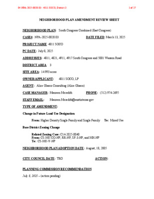
NEIGHBORHOOD PLAN AMENDMENT REVIEW SHEET NEIGHORHOOD PLAN: South Congress Combined (East Congress) CASE#: NPA-2025-0020.03 DATE FILED: March 13, 2025 PROJECT NAME: 4811 SOCO PC DATE: July 8, 2025 ADDRESS/ES: 4811, 4821, 4911, 4917 South Congress and 5001 Wasson Road DISTRICT AREA: 3 SITE AREA: 14.993 acres OWNER/APPLICANT: 4811 SOCO, LP AGENT: Alice Glasco Consulting (Alice Glasco) CASE MANAGER: Maureen Meredith PHONE: (512) 974-2695 STAFF EMAIL: Maureen.Meredith@austintexas.gov TYPE OF AMENDMENT: Change in Future Land Use Designation From: Higher Density Single Family and Single Family To: Mixed Use Base District Zoning Change Related Zoning Case: C14-2025-0040 From: CS-MU-CO-NP, RR-NP, SF-3-NP, and MH-NP To: CS-MU-V-NP NEIGHBORHOOD PLAN ADOPTION DATE: August, 18, 2005 CITY COUNCIL DATE: TBD ACTION: PLANNING COMMISSION RECOMMENDATION: July 8, 2025 – (action pending) 04 NPA-2025-0020.03 - 4811 SOCO; District 31 of 27 STAFF RECOMMENDATION: Staff supports the applicant’s request for Mixed Use land use. BASIS FOR STAFF’S RECOMMENDATION: The property has three future land use designations on the property, Higher Density Mixed Use on the northern part of the property, Mixed Use in the middle, and Single Family on the southern side of the property. Staff supports changing the land use to Mixed Use so the property can have a unified land use. The property has frontage along South Congress Avenue, which is an activity corridor where Mixed Use land use is appropriate. There is Mixed Use land use along South Congress Avenue and to the north, south and east of the property. South Congress Avenue has multiple bus routes and is near proposed S. Congress Ave Connector urban trails. 04 NPA-2025-0020.03 - 4811 SOCO; District 32 of 27 LAND USE DESCRIPTIONS: EXISTING LAND USE: Single family - Single family detached or up to three residential uses at typical urban and/or suburban densities. Purpose 1. Preserve the land use pattern and future viability of existing neighborhoods; 2. Encourage new infill development that continues existing neighborhood patterns of development; and 3. Protect residential neighborhoods from incompatible business or industry and the loss of existing housing. Application 1. Existing single‐family areas should generally be designated as single family to preserve established neighborhoods; and 2. May include small lot options (Cottage, Urban Home, Small Lot Single Family) and two‐family residential options (Duplex, Secondary Apartment, Single Family Attached, Two‐Family Residential) in areas considered appropriate for this type of infill development. Higher Density Single Family - Is housing, generally up to 15 units per acre, which includes townhouses and condominiums as well as traditional small‐lot single family. Purpose 1. Provide options for the development of higher‐density, owner‐occupied housing in urban areas; and 2. Encourage a mixture of moderate intensity residential on residential corridors. Application 1. Appropriate to manage development on major corridors that are primarily residential in nature, and 04 NPA-2025-0020.03 - 4811 SOCO; District 33 of 27 2. Can be used to provide a buffer between high‐density commercial and low‐density residential areas. 3. Applied to existing or proposed mobile home parks. PROPOSED LAND USE: Mixed Use - An area that is appropriate for a mix of residential and non‐residential uses. Purpose 1. Encourage more retail and commercial services within walking distance of residents; 2. Allow live‐work/flex space on existing commercially zoned land in the neighborhood; 3. Allow a mixture of complementary land use types, which may include housing, retail, offices, commercial services, and civic uses (with the exception of government offices) to encourage linking of trips; 4. Create viable development opportunities for underused center city sites; 5. Encourage the transition from non‐residential to residential uses; 6. Provide flexibility in land use standards to anticipate changes in the marketplace; 7. Create additional opportunities for the development of residential uses and affordable housing; and 8. Provide on‐street activity in commercial areas after 5 p.m. and built‐in customers for local businesses. Application 1. Allow mixed use development along major corridors and intersections; 2. Establish compatible mixed‐use corridors along the neighborhood’s edge 3. The neighborhood plan may further specify either the desired intensity of commercial uses (i.e. LR, GR, CS) or specific types of mixed use (i.e. Neighborhood Mixed Use Building, Neighborhood Urban Center, Mixed Use Combining District); 4. Mixed Use is generally not compatible with industrial development, however it may be combined with these uses to encourage an area to transition to a more complementary mix of development types; 04 NPA-2025-0020.03 - 4811 SOCO; District 34 of 27 5. The Mixed Use (MU) Combining District should be applied to existing residential uses to avoid creating or maintaining a non‐conforming use; and 6. Apply to areas where vertical mixed use development is encouraged such as Core Transit Corridors (CTC) and Future Core Transit Corridors. Yes Yes Imagine Austin Decision Guidelines Complete Community Measures Imagine Austin Growth Concept Map: Located within or adjacent to an Imagine Austin Activity Center, Imagine Austin Activity Corridor, or Imagine Austin Job Center as identified the Growth Concept Map. Name(s) of Activity Center/Activity Corridor/Job Center: • Frontage on South Congress Ave., an activity corridor Yes Mobility and Public Transit: Located within 0.25 miles of public transit stop and/or light rail station. Yes Mobility and Bike/Ped Access: Adjoins a public sidewalk, shared path, and/or bike lane. • Sidewalks and bike lanes on South Congress Ave. Yes Connectivity, Good and Services, Employment: Provides or is located within 0.50 miles to goods and services, and/or employment center. Yes Connectivity and Food Access: Provides or is located within 0.50 miles of a grocery store/farmers market. • 0.3 miles from All Star Grocery • 1.1 miles from La Buena Supermercado • 1.1 miles from Hula Market #1 No Connectivity and Education: Located within 0.50 miles from a public school or university. • 1.0 miles from St. Elmo Elem. School • 1.8 miles from Odom Elem. School • 1.8 miles from St. Edwards Univ. Yes Connectivity and Healthy Living: Provides or is located within 0.50 miles from a recreation area, park or walking trail. • 0.3 miles from Battle Bend Neighborhood Park • 0.7 miles from Heartwood Park • 0.8 miles from Tom Donovan Nature Trail at Williamson Creek Central Greenbelt Connectivity and Health: Provides or is located within 0.50 miles of health facility (ex: hospital, urgent care, doctor’s office, drugstore clinic, and/or specialized outpatient care.) • 0.7 miles from CVS MinuteClinic • 1.9 miles from Austin Oaks Hospital Yes Housing Affordability: Provides a minimum of 10% of units for workforce housing (80% MFI or less) and/or fee in lieu for affordable housing. • Applicant proposes approx. 350 apartment units with 10% affordable Yes Housing Choice: Expands the number of units and housing choice that suits a variety of household sizes, incomes, and lifestyle needs of a diverse population (ex: apartments, triplex, granny flat, live/work units, cottage homes, and townhomes) in support of Imagine Austin and the Strategic Housing Blueprint. • Proposed approx. 350 apartments Yes Mixed use: Provides a mix of residential and non-industrial uses. • Proposed multifamily and retail uses 04 NPA-2025-0020.03 - 4811 SOCO; District 35 of 27 No Culture and Creative Economy: Provides or is located within 0.50 miles of a cultural resource (ex: library, theater, museum, cultural center). • 1.6 miles from Pleasant Hill Branch Public Library Not known Not known Not known No 9 Culture and Historic Preservation: Preserves or enhances a historically and/or culturally significant site. Creative Economy: Expands Austin’s creative economy (ex: live music venue, art studio, film, digital, theater.) Workforce Development, the Economy and Education: Expands the economic base by creating permanent jobs, especially in industries that are currently not represented in particular area or that promotes a new technology, and/or promotes educational opportunities and workforce development training. Industrial Land: Preserves or enhances industrial land. Number of “Yeses” Proximity to Imagine Austin Activity Centers and Corridors 04 NPA-2025-0020.03 - 4811 SOCO; District 36 of 27 Proximity to Public Transportation 04 NPA-2025-0020.03 - 4811 SOCO; District 37 of 27 Proximity to Public Parks Proposed Urban Trails Map 04 NPA-2025-0020.03 - 4811 SOCO; District 38 of 27 IMAGINE AUSTIN GROWTH CONCEPT MAP Definitions Neighborhood Centers - The smallest and least intense of the three mixed-use centers are neighborhood centers. As with the regional and town centers, neighborhood centers are walkable, bikable, and supported by transit. The greatest density of people and activities in neighborhood centers will likely be concentrated on several blocks or around one or two intersections. However, depending on localized conditions, different neighborhood centers can be very different places. If a neighborhood center is designated on an existing commercial area, such as a shopping center or mall, it could represent redevelopment or the addition of housing. A new neighborhood center may be focused on a dense, mixed-use core surrounded by a mix of housing. In other instances, new or redevelopment may occur incrementally and concentrate people and activities along several blocks or around one or two intersections. Neighborhood centers will be more locally focused than either a regional or a town center. Businesses and services—grocery and department stores, doctors and dentists, shops, branch libraries, dry cleaners, hair salons, schools, restaurants, and other small and local businesses—will generally serve the center and surrounding neighborhoods. Town Centers - Although less intense than regional centers, town centers are also where many people will live and work. Town centers will have large and small employers, although fewer than in regional centers. These employers will have regional customer and employee bases, and provide goods and services for the center as well as the surrounding areas. The buildings found in a town center will range in size from one-to three-story houses, duplexes, townhouses, and rowhouses, to low-to midrise apartments, mixed use buildings, and office buildings. These centers will also be important hubs in the transit system. Regional Centers - Regional centers are the most urban places in the region. These centers are and will become the retail, cultural, recreational, and entertainment destinations for Central Texas. These are the places where the greatest density of people and jobs and the tallest buildings in the region will be located. Housing in regional centers will mostly consist of low to high-rise apartments, mixed use buildings, row houses, and townhouses. However, other housing types, such as single-family units, may be included depending on the location and character of the center. The densities, buildings heights, and overall character of a center will depend on its location. Activity Centers for Redevelopment in Sensitive Environmental Areas - Five centers are located over the recharge or contributing zones of the Barton Springs Zone of the Edwards Aquifer or within water-supply watersheds. These centers are located on already developed areas and, in some instances, provide opportunities to address long-standing water quality issues and provide walkable areas in and near existing neighborhoods. State-of-the-art development practices will be required of any redevelopment to improve stormwater retention and the water quality flowing into the aquifer or other drinking water sources. These centers should also be carefully evaluated to fit within their infrastructural and environmental context. 04 NPA-2025-0020.03 - 4811 SOCO; District 39 of 27 Job Centers - Job centers accommodate those businesses not well-suited for residential or environmentally- sensitive areas. These centers take advantage of existing transportation infrastructure such as arterial roadways, freeways, or the Austin-Bergstrom International airport. Job centers will mostly contain office parks, manufacturing, warehouses, logistics, and other businesses with similar demands and operating characteristics. They should nevertheless become more pedestrian and bicycle friendly, in part by better accommodating services for the people who work in those centers. While many of these centers are currently best served by car, the growth Concept map offers transportation choices such as light rail and bus rapid transit to increase commuter options. Corridors - Activity corridors have a dual nature. They are the connections that link activity centers and other key destinations to one another and allow people to travel throughout the city and region by bicycle, transit, or automobile. Corridors are also characterized by a variety of activities and types of buildings located along the roadway — shopping, restaurants and cafés, parks, schools, single-family houses, apartments, public buildings, houses of worship, mixed-use buildings, and offices. Along many corridors, there will be both large and small redevelopment sites. These redevelopment opportunities may be continuous along stretches of the corridor. There may also be a series of small neighborhood centers, connected by the roadway. Other corridors may have fewer redevelopment opportunities, but already have a mixture of uses, and could provide critical transportation connections. As a corridor evolves, sites that do not redevelop may transition from one use to another, such as a service station becoming a restaurant or a large retail space being divided into several storefronts. To improve mobility along an activity corridor, new and redevelopment should reduce per capita car use and increase walking, bicycling, and transit use. Intensity of land use should correspond to the availability of quality transit, public space, and walkable destinations. Site design should use building arrangement and open space to reduce walking distance to transit and destinations, achieve safety and comfort, and draw people outdoors. BACKGROUND: The applicant proposes to change the land use on the future land use map from High Density Single Family and Single Family to Mixed Use. There is existing Mixed Use land use on a large portion of the property. The applicant proposes to change the zoning on the property from CS-MU-CO-NP (General Commercial Services district– Mixed Use combining district—Conditional Overlay combining district—Neighborhood Plan), RR-NP (Rural Residence district—Neighborhood Plan), SF-3-NP (Family Residence district—Neighborhood Plan), and Mobile Home Residence district—Neighborhood Plan) to CS-MU-V-NP (General Commercial Services district—Mixed Use combining district –Vertical Mixed Use Building combining district— Neighborhood Plan) for multifamily and retail. For more information the proposed zoning, see case report C14-2025-0040. 04 NPA-2025-0020.03 - 4811 SOCO; District 310 of 27 PUBLIC MEETINGS: The ordinance-required community meeting was virtually held on April 17, 2025. The recorded meeting can be found here: https://publicinput.com/neighborhoodplanamendmentcases. Approximately 577 community meeting notices were mailed to people with utility accounts or own property within 500 feet of the subject properties, in addition to neighborhood and environmental groups who requested notification for the area. Two city staff members attended the meeting from the Planning Department, Maureen Meredith and Mark Walters, in addition to Alice Glasco, the applicant’s agent with Ryan Meany from AGDC. Eight people from the neighborhood attended. Below are highlights from Alice Glasco’s presentation: • Our request is change the FLUM to Mixed Use so the entire property will be Mixed Use land use. • The conditional overlay is one that is part of the 2005 rezoning that was done with enabled plan and there's a conditional overlay that requires a 30 foot vegetative buffer along the east side of the property line. We'll be carrying that over with a rezoning. • The zoning change is to keep the CS-MU-CO-NP, we are adding V to the zoning to allow us to build as much as we can build on the property. It doesn’t increase the height, but it allows more residential. Under the current zoning with MU can get up to 300 apartments, but with VMU, we could get approximately 350 with ground floor retail. • Under the MU, there is no affordable housing required, but with the VMU, we get additional residential units, with 10% of total units to be set aside for the MFI. Q: My neighborhood is concerned about light pollution. Are there any steps to protect the neighborhood from that? During construction, will the Greenbelt be protected? A: Under the city's regulations there are compatibility standards, where all projects like ours are required to address the light pollution, your lights cannot be shining, so they have to be hooded. When we get to the city submittal process for site plan, we will find out from the Parks Department what requirements we need to comply with regarding the Greenbelt. So all those aspects will be addressed at the time of site development permit submittal. Q: We are most concerned about the height and set back of the development on the eastern boundary with the new zoning compared to what is allowed today. Can you please clarify how high the buildings can be built today and how close versus what will be allowed under this proposed zoning change? A: The CS zoning has a maximum height of 60 feet, but the compatibility standards would apply which would step back protection from single family homes. Also, there is a 30-foot vegetative buffer along the eastern property line that we will keep from the previous conditional overlay and are willing to extend along the property line. 04 NPA-2025-0020.03 - 4811 SOCO; District 311 of 27 Q: There is wildlife including a family of deer, fox, etcetera that are very present at this property. What will be done in terms of wildlife preservation? A: We haven’t determined how to handle that when we get to the development stage. I don't think the city of Austin has any requirements for handing wildlife on the property. But we'll certainly confer with the appropriate entities as to what we can do to deal with that. Q: The southern part of the property also has a wet weather Creek that runs into Williamson, which, from my understanding, both have the critical water quality zones allowing for additional set back. The watershed ordinance requires setbacks from the critical water quality zones, is that correct? A: We will have to adhere to all the city requirements and setbacks at the at the time of site plan work with the watershed protection staff and their city regulations regarding those regulations. Q: For the 30-foot vegetative buffer, are there requirements that it be evergreen material or trees versus shrubs or anything like that, so it’s not just a flat area of grass, but it actually shields the light from some of those neighbors? A: The ordinance just reads that there will be a 30-foot vegetative buffer, so whatever trees that are there will be preserved, and any additional landscaping will be put in place. I believe the compatibility standards that council adopted recently has very specific requirements for vegetation in that area. Q: Will there be privacy fencing by the single-family homes? With a 60-foot building, people will be looking down onto our backyards. A: The 60-foot building will be 50 feet away from the single-family homes because of the compatibility standards. Also, there is a fence requirement with commercial next to residential uses, so yes, there will be a fence. Q: Regarding the creek, I'm concerned about the drainage. The easement fills up now after rain and gets out of its banks at times. I'm concerned with less permeable land and more concrete. The drainage easement will not be enough and will further erode our property. A: The City requires all new developments have an outside detention pond that detains the water and releases the water as it did with grass on the property. Q: Do you have details on how the properties will be developed? Are the owners planning to keep the property if rezoned or do they plan to sell? A: They plan to keep the property. 04 NPA-2025-0020.03 - 4811 SOCO; District 312 of 27 Q: Will there be an onsite pet area 600 to 800 feet? A: The city requires under subject under the commercial design standards required to have open space of a minimum of 650 square feet, so the city will require open space. 04 NPA-2025-0020.03 - 4811 SOCO; District 313 of 27 Applicant’s Summary Letter from Application 04 NPA-2025-0020.03 - 4811 SOCO; District 314 of 27 04 NPA-2025-0020.03 - 4811 SOCO; District 315 of 27 Letter of Recommendation from the Neighborhood Plan Contact Team (NPCT) (No letter as of July 2, 2025) From: Meredith, Maureen Sent: Tuesday, July 1, 2025 5:15 PM To: Mario Cantu < Cc: Estrada, Nancy <Nancy.Estrada@austintexas.gov> Subject: SCC NPCT Rec: July 8 PC date- NPA-2025-0020.03 & C14-2025-0040_4811 S. Congress Ave. Importance: High Mario: I was looking through my emails and realized I might not have sent to you a request for a letter of recommendation for these cases (NPA-2025-0020.03 and C14-2025-0040_4811, 4821, 4911, 4917 South Congress Ave and 5001 Wasson Rd) that will be on the July 8th PC hearing, although you probably already received the public hearing notices in the mail and are aware that these cases will be on that hearing date. If you would like to have a letter of recommendation included in our staff reports, please email it to me and Nancy by 5:00 pm tomorrow, July 2nd, or we can submit it as late material to the Planning Commission. Thanks. Maureen 04 NPA-2025-0020.03 - 4811 SOCO; District 316 of 27 Site 04 NPA-2025-0020.03 - 4811 SOCO; District 317 of 27 04 NPA-2025-0020.03 - 4811 SOCO; District 318 of 27 04 NPA-2025-0020.03 - 4811 SOCO; District 319 of 27 04 NPA-2025-0020.03 - 4811 SOCO; District 320 of 27 04 NPA-2025-0020.03 - 4811 SOCO; District 321 of 27 04 NPA-2025-0020.03 - 4811 SOCO; District 322 of 27 04 NPA-2025-0020.03 - 4811 SOCO; District 323 of 27 Alice Glasco’s Presentation at the Virtual Community Meeting 04 NPA-2025-0020.03 - 4811 SOCO; District 324 of 27 Correspondence Received From: Alice Glasco < Sent: Thursday, April 17, 2025 1:27 PM To: Meredith, Maureen <Maureen.Meredith@austintexas.gov> Cc: Estrada, Nancy <Nancy.Estrada@austintexas.gov> Subject: RE: PLAN AMENDMENT CASE# NPA-2025-0020.03 Maureen, Received. Thank you! ==================== Alice Glasco, President Alice Glasco Consulting 512-231-8110 W 512-626-4461 C From: Meredith, Maureen <Maureen.Meredith@austintexas.gov> Sent: Thursday, April 17, 2025 11:56 AM To: Alice Glasco < Cc: Estrada, Nancy <Nancy.Estrada@austintexas.gov> Subject: FW: PLAN AMENDMENT CASE# NPA-2025-0020.03 Alice: Please see Lonny Stern’s email below. He said it was OK for me to give you his email. Maureen From: Lonny Stern < Sent: Wednesday, April 16, 2025 7:19 PM To: Meredith, Maureen <Maureen.Meredith@austintexas.gov> Subject: PLAN AMENDMENT CASE# NPA-2025-0020.03 Hello Maureen - I am writing today because I saw the public notice about the virtual community meeting for Plan Amendment Case #NPA-202500020.03, Zoning Case # C14-2025-0040 re: 4811, 4821, 4911, 4917 South Congress Ave & 5001 Wasson Road. 04 NPA-2025-0020.03 - 4811 SOCO; District 325 of 27 I am not able to attend the public meeting being held on Thursday, April 17, 2025. As such, I am writing to share public feedback for the developer to consider: 1) Can the applicant please provide bike/pedestrian access to/from Liverpool Drive? The properties in question abut Liverpool Drive to the east. A mobility easement would *significantly* cut down the time it takes for Battle Bend residents to access South Congress Avenue. This is important for those who want to use transit or patronize the many services available on the boulevard without using a car. It will also make it easier for Battle Bend residents to access Williamson Creek Park (in the future) and for residents of the incoming development to access Battle Bend Park. 2) To ensure that the property is developed as mixed-use residences with commercial retail (as intended by the developer), can the applicant please include the following prohibited uses as a conditional overlay?: Commercial Uses: • Agricultural Sale and Services • Building Maintenance Services • Campground • Carriage Stable • Convenience Storage • Drop-off Recycling Collection Facility • Electronic Prototype Assembly • Electronic Testing • Equipment Repair Services • Equipment Sales • Exterminating Services • Funeral Services • Marina • Recreational Equipment Maintenance & Storage • Recreational Equipment Sales • Research Assembly Services • Research Testing Services • Research Warehousing Services • Scrap and Salvage • Service Station • Stables • Vehicle Storage Industrial Uses: • Basic Industry • General Warehousing and Distribution • Recycling Center • Resource Extraction 04 NPA-2025-0020.03 - 4811 SOCO; District 326 of 27 Agricultural Uses: • Animal Production • Crop Production • Indoor Crop Production Thank you for sharing these comments with the applicant and including them in the official packet for this case. Yours -- Lonny Lonny Stern, MPA -------------------------------------- 4361 S. Congress Ave #231 Austin, TX 78745 512.484.3440 cell LinkedIn | Twitter | Realtor.com 04 NPA-2025-0020.03 - 4811 SOCO; District 327 of 27