15 C20-2025-001 - Amendments to the East Riverside Corridor Regulating Plan; District 3 - Staff Report - Part 3 — original pdf
Backup
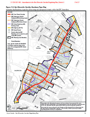
Figure 1-3: East Riverside Corridor Roadway Type Map Indicates the Roadway type for all existing and proposed streets within the ERC boundary. City of Austin - East Riverside Corridor Regulating Plan 13 0500’1000’2000’SCALENORTHE. RIVERSIDE DRS. PLEASANT VALLEY RDGROVE BLVDMONTOPOLIS DRE. OLTORF STBURTON DRTINNIN FORD RDWOODLAND AVEVARGAS RDFRONTIER VALLEY DRCROSSING PLPARKER LNELMONT DRACC RiversideRuiz LibraryAllison ElementaryBaty ElementaryWILLOW CREEK DRWICKERSHAM LNLady Bird LakeE. RIVERSIDE DRLAKESHORE DRPARKER LNBURTON DRS. PLEASANT VALLEY RDWICKERSHAM LNROYAL CREST DRRIVERSIDE FARMS RDMONTOPOLIS DRGROVE BLVDTHRASHER LNMAXWELL LNAIRPORT COMMERCE RDFAIRWAY STSANTOS STPORTER STHOGAN AVEFELIX STPONCA STKEMP STSUNRIDGE DRBURLESON RDIH-35HWY 71BASTROP HWYLEGENDERC Core Transit CorridorERC Pedestrian Priority Collector (PPC) Existing streetsERC Pedestrian Priority Collector (PPC) Future StreetsERC Urban Roadway (UR) Existing streetsERC Highway (HWY)ERC Zoned ParcelParcel within the ERC Boundary not re-zoned as part of the ERC processERC Planning Area BoundaryParcel BoundaryNote: All new streets not identified as another roadway type on this map will be designated ERC Urban Roadways.This product is for informational purposes and may not have been prepared for or be suitable for legal, engineering, or surveying purposes. It does not represent an on-the-ground survey and represents only the approximate relative location of property boundaries.This product has been produced by the Planning and Development Review Department for the sole purpose of geographic reference. No warranty is made by the City of Austin regarding specific accuracy or completeness.15 C20-2025-001 - Amendments to the East Riverside Corridor Regulating Plan; District 317 of 27 Figure 1-4: East Riverside Corridor Active Edges Map This map shows properties that have an active edge requirement and on which street face the active edge is located. The requirements for Active Edges can be found in Section 5.6 of this document. 14 City of Austin - East Riverside Corridor Regulating Plan E. RIVERSIDE DRS. PLEASANT VALLEY RDGROVE BLVDMONTOPOLIS DRE. OLTORF STTINNIN FORD RDWOODLAND AVEVARGAS RDFRONTIER VALLEY DRCROSSING PLPARKER LNELMONT DRACC RiversideRuiz LibraryAllison ElementaryBaty ElementaryWILLOW CREEK DRWICKERSHAM LNLady Bird LakeE. RIVERSIDE DRLAKESHORE DRPARKER LNBURTON DRS. PLEASANT VALLEY RDWICKERSHAM LNROYAL CREST DRRIVERSIDE FARMS RDMONTOPOLIS DRGROVE BLVDTHRASHER LNMAXWELL LNAIRPORT COMMERCE RDFAIRWAY STSANTOS STPORTER STHOGAN AVEFELIX STPONCA STKEMP STSUNRIDGE DRBURLESON RDIH-35HWY 71BASTROP HWY0500’1000’2000’SCALENORTH LEGENDActive EdgesERC Zoned ParcelERC Planning Area BoundaryParcel BoundaryParcel within the ERC Boundary not re-zoned as part of ERC processThis product is for informational purposes and may not have been prepared for or be suitable for legal, engineering, or surveying purposes. It does not represent an on-the-ground survey and represents only the approximate relative location of property boundaries.This product has been produced by the Planning and Development Review Department for the sole purpose of geographic reference. No warranty is made by the City of Austin regarding specific accuracy or completeness.15 C20-2025-001 - Amendments to the East Riverside Corridor Regulating Plan; District 318 of 27 Figure 1-5: East Riverside Corridor Collector Street Map Shows existing and new streets designated as Collector streets. City of Austin - East Riverside Corridor Regulating Plan 15 0500’1000’2000’SCALENORTHE. RIVERSIDE DRS. PLEASANT VALLEY RDGROVE BLVDMONTOPOLIS DRE. OLTORF STBURTON DRTINNIN FORD RDWOODLAND AVEVARGAS RDFRONTIER VALLEY DRCROSSING PLPARKER LNELMONT DRACC RiversideRuiz LibraryAllison ElementaryBaty ElementaryWILLOW CREEK DRWICKERSHAM LNLady Bird LakeE. RIVERSIDE DRLAKESHORE DRPARKER LNS. PLEASANT VALLEY RDWICKERSHAM LNROYAL CREST DRRIVERSIDE FARMS RDMONTOPOLIS DRGROVE BLVDTHRASHER LNMAXWELL LNAIRPORT COMMERCE RDFAIRWAY STSANTOS STPORTER STHOGAN AVEFELIX STPONCA STKEMP STSUNRIDGE DRBURLESON RDIH-35HWY 71BASTROP HWYLEGENDExisting Streets ERC Zoned ParcelParcel BoundaryUpgrade existing street to collector streetRequired new collector streetERC Planning Area BoundaryRequired collector street connection pointLocation of connection is flexibleNote: Collector street alignments shown are approximate and may be located on different ownership parcels. ROW dedication and reservation on specific parcels shall be determined in accordance with LDC Chapter 25-6, Article 2. Parcel within the ERC Boundary not re-zoned as part of the ERC processThis product is for informational purposes and may not have been prepared for or be suitable for legal, engineering, or surveying purposes. It does not represent an on-the-ground survey and represents only the approximate relative location of property boundaries.This product has been produced by the Planning and Development Review Department for the sole purpose of geographic reference. No warranty is made by the City of Austin regarding specific accuracy or completeness.Future potential collector street15 C20-2025-001 - Amendments to the East Riverside Corridor Regulating Plan; District 319 of 27 Figure 1-6: East Riverside Corridor Hub Map This map shows the Hubs within the ERC boundary. Properties located within a Hub are eligible for addi- tional entitlements as outlined in Article 6. 16 City of Austin - East Riverside Corridor Regulating Plan As amended per Ordinance No. 20141106-084 adopted 11-17-2014. 16E. RIVERSIDE DRS. PLEASANT VALLEY RDGROVE BLVDMONTOPOLIS DRE. OLTORF STTINNIN FORD RDWOODLAND AVEVARGAS RDFRONTIER VALLEY DRCROSSING PLPARKER LNELMONT DRACC RiversideRuiz LibraryAllison ElementaryBaty ElementaryWILLOW CREEK DRWICKERSHAM LNLady Bird LakeE. RIVERSIDE DRLAKESHORE DRPARKER LNBURTON DRS. PLEASANT VALLEY RDWICKERSHAM LNROYAL CREST DRRIVERSIDE FARMS RDMONTOPOLIS DRGROVE BLVDTHRASHER LNMAXWELL LNAIRPORT COMMERCE RDFAIRWAY STSANTOS STPORTER STHOGAN AVEFELIX STPONCA STKEMP STSUNRIDGE DRBURLESON RDIH-35HWY 71BASTROP HWY0500’1000’2000’SCALENORTH LEGENDHub BoundaryERC Planning Area BoundaryParcel Zoned ERCParcel within the ERC Boundary not re-zoned as part of the ERC processFIGURE 1-6: East Riverside Corridor Hub MapThis product is for informational purposes and may not have been prepared for or be suitable for legal, engineering, or surveying purposes. It does not represent an on-the-ground survey and represents only the approximate relative location of property boundaries.This product has been produced by the Planning and Development Review Department for the sole purpose of geographic reference. No warranty is made by the City of Austin regarding specific accuracy or completeness.This map shows the Hubs within the ERC boundary. Properties located within a Hub are eligible for additional entitlements as outlined in Article 6. entitlements as outlined in Article 6.As amended per Ordinance No. _______________ adopted ____________ .20141106-08411-17-2014City of Austin - East Riverside Corridor Regulating PlanUpdated 12/27/2315 C20-2025-001 - Amendments to the East Riverside Corridor Regulating Plan; District 320 of 27 Figure 1-7: East Riverside Corridor Height Map This map shows allowable building heights on a parcel without a development bonus. City of Austin - East Riverside Corridor Regulating Plan 17 0500’1000’2000’SCALENORTHE. RIVERSIDE DRS. PLEASANT VALLEY RDGROVE BLVDMONTOPOLIS DRE. OLTORF STBURTON DRTINNIN FORD RDWOODLAND AVEVARGAS RDFRONTIER VALLEY DRCROSSING PLPARKER LNELMONT DRACC RiversideRuiz LibraryAllison ElementaryBaty ElementaryWILLOW CREEK DRWICKERSHAM LNLady Bird LakeE. RIVERSIDE DRLAKESHORE DRPARKER LNS. PLEASANT VALLEY RDWICKERSHAM LNROYAL CREST DRRIVERSIDE FARMS RDMONTOPOLIS DRGROVE BLVDTHRASHER LNMAXWELL LNAIRPORT COMMERCE RDFAIRWAY STSANTOS STPORTER STHOGAN AVEFELIX STPONCA STKEMP STSUNRIDGE DRBURLESON RDIH-35HWY 71BASTROP HWYFIGURE 1-7: East Riverside Corridor Height MapLEGEND35 feet40 feet50 feet60 feetERC Planning Area BoundaryParcel BoundaryParcel within the ERC Boundary not re-zoned as part of the ERC process This product is for informational purposes and may not have been prepared for or be suitable for legal, engineering, or surveying purposes. It does not represent an on-the-ground survey and represents only the approximate relative location of property boundaries.This product has been produced by the Planning and Development Review Department for the sole purpose of geographic reference. No warranty is made by the City of Austin regarding specific accuracy or completeness.This map shows allowable building heights on a parcel without a development bonus.entitlements as outlined in Article 6. As amended per Ordinance No. _______________ adopted ____________ .20141106-08411-17-201417City of Austin - East Riverside Corridor Regulating Plan15 C20-2025-001 - Amendments to the East Riverside Corridor Regulating Plan; District 321 of 27 Figure 1-8: East Riverside Corridor Development Bonus Height Map This map shows eligible properties and maximum heights allowed with a development bonus. This product is for informational purposes and may not have been prepared for or be suitable for legal, engineering, or surveying purposes. It does not represent an on-the-ground survey and represents only the approximate relative location of property boundaries. This product has been produced by the Planning and Development Review Department for the sole purpose of geographic reference. No warranty is made by the City of Austin regarding specific accuracy or completeness. 18 City of Austin - East Riverside Corridor Regulating Plan 0500’1000’2000’SCALENORTHFIGURE 1-8: East Riverside Corridor Development Bonus Height MapLEGENDIneligible for Development Bonus65 feet120 feet160 feetERC Planning Area BoundaryParcel BoundaryParcel within the ERC Boundary not re-zoned as part of ERC processThis product is for informational purposes and may not have been prepared for or be suitable for legal, engineering, or surveying purposes. It does not represent an on-the-grounsurvey and represents only the approximate relative location of ro oundaries.This product has been produced by the Planning and Development Revie Dpartment for the sole purpose of geographic reference. No warranty is made by the City f Austin regarding specic accuracy or compless.This map shows eligible properties and maximum heights allowed with a development bonus. As amended per Ordinance No. _______________ adopted ____________ .20141106-08411-17-2014nalP gnitalugeR rodirroC edisreviR tsaE - nitsuA fo ytiC81Updated 12/27/2315 C20-2025-001 - Amendments to the East Riverside Corridor Regulating Plan; District 322 of 27