15 C20-2025-001 - Amendments to the East Riverside Corridor Regulating Plan; District 3 - Staff Report - Part 2 — original pdf
Backup
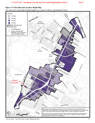
Figure 1-7: East Riverside Corridor Height Map This map shows allowable building heights on a parcel without a development bonus. Subject property City of Austin - East Riverside Corridor Regulating Plan 17 0500’1000’2000’SCALENORTHE. RIVERSIDE DRS. PLEASANT VALLEY RDGROVE BLVDMONTOPOLIS DRE. OLTORF STBURTON DRTINNIN FORD RDWOODLAND AVEVARGAS RDFRONTIER VALLEY DRCROSSING PLPARKER LNELMONT DRACC RiversideRuiz LibraryAllison ElementaryBaty ElementaryWILLOW CREEK DRWICKERSHAM LNLady Bird LakeE. RIVERSIDE DRLAKESHORE DRPARKER LNS. PLEASANT VALLEY RDWICKERSHAM LNROYAL CREST DRRIVERSIDE FARMS RDMONTOPOLIS DRGROVE BLVDTHRASHER LNMAXWELL LNAIRPORT COMMERCE RDFAIRWAY STSANTOS STPORTER STHOGAN AVEFELIX STPONCA STKEMP STSUNRIDGE DRBURLESON RDIH-35HWY 71BASTROP HWYFIGURE 1-7: East Riverside Corridor Height MapLEGEND35 feet40 feet50 feet60 feetERC Planning Area BoundaryParcel BoundaryParcel within the ERC Boundary not re-zoned as part of the ERC process This product is for informational purposes and may not have been prepared for or be suitable for legal, engineering, or surveying purposes. It does not represent an on-the-ground survey and represents only the approximate relative location of property boundaries.This product has been produced by the Planning and Development Review Department for the sole purpose of geographic reference. No warranty is made by the City of Austin regarding specific accuracy or completeness.This map shows allowable building heights on a parcel without a development bonus.entitlements as outlined in Article 6. As amended per Ordinance No. _______________ adopted ____________ .20141106-08411-17-201417City of Austin - East Riverside Corridor Regulating Plan15 C20-2025-001 - Amendments to the East Riverside Corridor Regulating Plan; District 310 of 27 Figure 1-8: East Riverside Corridor Development Bonus Height Map This map shows eligible properties and maximum heights allowed with a development bonus. Subject property 18 City of Austin - East Riverside Corridor Regulating Plan 0500’1000’2000’SCALENORTHFIGURE 1-8: East Riverside Corridor Development Bonus Height MapLEGENDIneligible for Development Bonus65 feet120 feet160 feetERC Planning Area BoundaryParcel BoundaryParcel within the ERC Boundary not re-zoned as part of ERC processThis product is for informational purposes and may not have been prepared for or be suitable for legal, engineering, or surveying purposes. It does not represent an on-the-ground survey and represents only the approximate relative location of property boundaries.This product has been produced by the Planning and Development Review Department for the sole purpose of geographic reference. No warranty is made by the City of Austin regarding specic accuracy or completeness.This map shows eligible properties and maximum heights allowed with a development bonus. As amended per Ordinance No. _______________ adopted ____________ .20141106-08411-17-2014nalP gnitalugeR rodirroC edisreviR tsaE - nitsuA fo ytiC81Updated 12/27/2315 C20-2025-001 - Amendments to the East Riverside Corridor Regulating Plan; District 311 of 27 Figure 1-15: Map of Properties with Drive-Through Facilities Map of properties to which Subsection 2.3.5.B (Drive-Through Facilities) and Subsection 4.5 (Drive- Through Facilities) applies. LEGEND ERC Zoned Parcel Parcel within the ERC Boundary that will not be re-zoned as part of ERC Process ERC Planning Area Boundary Parcel Boundary ERC Zoned Property with drive-through facility legally constructed or permitted prior to May 9, 2013. O R T S A B Y W P H SP-2013-0148C Allison Elementary SP-2013-0107C F R O N TIE R V A A I R C O P O M R M T E R C E R D NCA ST PO KEM P ST V A R G AS R D NTOPOLIS DR FELIX ST M O E N AV A G O H L L E Y D R RTER ST O P S ST TO N A S GROVE BLVD ACC Riverside 463939 T Y S A W FAIR Ruiz Library R E D SID R E E. RIV V D L E B G R O V H W Y 7 1 M A X W ELL LN T H R A S H ER L N M O NTOPOLIS DR Baty Elementary RIVERSIDE FAR MS RD T F S R O LT E. O C R O S SIN G P L S. PLEASA WICKERSHA M LN NT VALLEY RD Lady Bird Lake Subject property 285507 463854 507723 507721 285464 SP-2012-03 79C 283800 283792 E. RIVERSIDE DR R E D R O H S E K A L TIN NIN FORD RD 729529 729530 285511 R E D S I D R 719303 E E . R I V 285451 ROYAL CREST DR PARKER LN 445742 286707 363720 S. PLEASA NT VALLEY RD W I C K E R S H A M L N S U N R I D G E D R B U R T O N D R WILLO W CREEK DR 808927 D AVE N DLA O O W PARKER LN B U R L E S O N R D SCALE NORTH 0 1000’ 500’ 2000’ IH-35 This product is for informational purposes and may not have been prepared for or be suitable for legal, engineering, or surveying purposes. It does not represent an on-the-ground survey and represents only the approximate relative location of property boundaries. This product has been produced by the Planning and Development Review Department for the sole purpose of geographic reference. No warranty is made by the City of Austin regarding specific accuracy or completeness. City of Austin - East Riverside Corridor Regulating Plan 25 15 C20-2025-001 - Amendments to the East Riverside Corridor Regulating Plan; District 312 of 27 Figure 1-17: Map of Properties with Service Stations Map of properties to which Figure 2-1: Land Use Table, Service Station permitted or constructed prior to May 9, 2013, applies. LEGEND ERC Zoned Parcel Parcel within the ERC Boundary that will not be re-zoned as part of ERC Process ERC Planning Area Boundary Parcel Boundary ERC Zoned Property with a service station legally constructed or permitted prior to May 9, 2013. Lady Bird Lake Subject property R E D R O H S E K A L Y W P H O R Allison Elementary T S A B A I R C O P SP-2013-0107C O M R M T E R C E R D F R O N TIE R V A NCA ST PO KEM P ST V A R G AS R D NTOPOLIS DR FELIX ST M O E N AV A G O H L L E Y D R 712089 ORTER ST P T S S NTO A S 289298 289367 T AY S W FAIR GROVE BLVD ACC Riverside Ruiz Library C R O S SIN G P L S. PLEASA WICKERSHA M LN 285046 NT VALLEY RD 287442 286714 H W Y 7 1 M A X W ELL LN T H R AS H ER LN R E D SID R E E. RIV 290485 V D L E B G R O V M O NTOPOLIS DR T F S R O LT E. O Baty Elementary RIVERSIDE FAR MS RD 817835 W I C K E R S H A M L N S U N R I D G E D R TIN NIN FORD RD R E D S I D R E E . R I V ROYAL CREST DR PARKER LN 285484 S. PLEASA NT VALLEY RD B U R T O N D R WILLO 286259 W CREEK DR D AVE 2013-029979 PR N DLA O O W PARKER LN B U R L E S O N R D 283793 E. RIVERSIDE DR SCALE NORTH 0 1000’ 500’ 2000’ IH-35 This product is for informational purposes and may not have been prepared for or be suitable for legal, engineering, or surveying purposes. It does not represent an on-the-ground survey and represents only the approximate relative location of property boundaries. This product has been produced by the Planning and Development Review Department for the sole purpose of geographic reference. No warranty is made by the City of Austin regarding specific accuracy or completeness. City of Austin - East Riverside Corridor Regulating Plan 27 15 C20-2025-001 - Amendments to the East Riverside Corridor Regulating Plan; District 313 of 27 C20-2025-001 Exhibit “B” Proposed Modified Figures to the ERC Regulating Plan 15 C20-2025-001 - Amendments to the East Riverside Corridor Regulating Plan; District 314 of 27 15 C20-2025-001 - Amendments to the East Riverside Corridor Regulating Plan; District 315 of 27 15 C20-2025-001 - Amendments to the East Riverside Corridor Regulating Plan; District 316 of 27