07 C14-2025-0019 - 1301, 1303, and 1305 E. 4th Street; District 3 Staff Report — original pdf
Backup
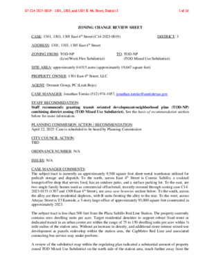
ZONING CHANGE REVIEW SHEET CASE: 1301, 1303, 1305 East 4th Street (C14-2025-0019) DISTRICT: 3 ADDRESS: 1301, 1303, 1305 East 4th Street ZONING FROM: TOD-NP TO: TOD-NP (Live/Work Flex Subdistrict) (TOD Mixed Use Subdistrict) SITE AREA: approximately 0.4515 acres (approximately 19,667 square feet) PROPERTY OWNER: 1301 East 4th Street, LLC AGENT: Drenner Group, PC (Leah Bojo) CASE MANAGER: Jonathan Tomko (512) 974-1057, jonathan.tomko@austintexas.gov STAFF RECOMMEDATION: Staff recommends granting transit oriented development-neighborhood plan (TOD-NP) combining district zoning (TOD Mixed Use Subdistrict). See the basis of recommendation section below for more information. PLANNING COMMISSION ACTION / RECOMMENDATION: April 22, 2025: Case is scheduled to be heard by Planning Commission CITY COUNCIL ACTION: TBD ORDINANCE NUMBER: N/A ISSUES: N/A CASE MANAGER COMMENTS: The subject tract is currently an approximately 9,500 square foot sheet metal warehouse utilized for pedicab storage and dispatch. To the north, across East 4th Street is Cosmic Saltillo, a cocktail lounge/coffee shop that serves food, has an outdoor patio, and a surface parking lot. To the east, are two single family homes used as commercial office/retail, recently rezoned through zoning case C14- 2023-0153 (1307 and 1309 East 4th Street), see area case histories section below. To the south, across the alley are three residential duplexes, with B units fronting the alley to the rear. To the west, across Attayac Street is T3 Eastside, a 3-story large office of approximately 93,000 square feet constructed in approximately 2023. The subject tract is less than 500 feet from the Plaza Saltillo Red Line Station. The property currently contains zero dwelling units per acre. Target residential densities to support robust fixed-route or dedicated transit in an urban center are within the range of 75 to 150 dwelling units per acre within ½ mile radius of the station area. Without an increase in density, and additional more intense mixed-use development as parcels redevelop within the station area, the CapMetro Red Line and associated connecting bus service may under-perform. A review of the subdistrict map within the regulating plan indicated a substantial amount of property zoned TOD Mixed Use Subdistrict on the north side of the station area, much further away from the 07 C14-2025-0019 - 1301, 1303, and 1305 E. 4th Street; District 31 of 16 station area. The TOD Mixed Use Subdistrict is found more than 3 times as far away from the station as the subject tract. This distribution is not uniform and there is not a compelling reason to maintain this distribution given its proximity to the station. BASIS OF RECOMMENDATION: The proposed zoning should be consistent with the purpose statement of the district sought. Areas zoned (TOD-NP) TOD Mixed Use Subdistrict are located in the closest proximity to transit and is the highest density district designation within the Plaza Saltillo Station Area Plan. This subdistrict encourages urban-style development including active ground floor uses with commercial, office, or residential uses on the upper floors. Residential densities may exceed 45 units per acre if a specific level of affordable housing is provided. Moderate height bonuses allowing a total building height of 85 feet may also be granted with additional affordable housing. Zoning changes should promote compatibility with adjacent and nearby uses. Staff recommends (TOD-NP) TOD Mixed Use Subdistrict zoning for the property based on the following considerations: 1) proximity to the Plaza Saltillo station; 2) it is consistent with the development that has been granted within the regulating plan, 3) it is reasonable given the changes in the area since the TOD Plan was adopted in 2008. There has been substantial redevelopment in the immediate area, 4) the rezoning would support goals in the Austin Strategic Housing Blueprint by providing more affordable housing within ¼ mile of high-frequency transit. Zoning should promote clearly identified community goals, such as creating employment opportunities or providing for affordable housing. This rezoning case presents an opportunity as older properties within the station area begin to redevelop, to increase housing density and a mix of uses to a level that will support fixed route transit. This case can also support community goals by increasing a mix of uses which can support more employment opportunities and supports transit at the same time by providing more destinations within the station area. Lastly, the rezoning request also could result in additional income restricted affordable housing in exchange for a density bonus, or super density bonus. Income restricted housing units near transit achieve a deeper level of affordability due to their locational advantages, they can reduce what is typically a household’s second largest expense, transportation costs. EXISTING ZONING AND LAND USES: Site North (across E. 4th St.) South East West (across ZONING TOD-NP (Live/Work Flex Subdistrict) TOD-CURE-NP, TOD-H-NP, and TOD-NP (TOD Mixed Use Subdistrict) SF-3-NP TOD-NP (TOD Mixed Use Subdistrict) TOD-NP (LiveWork/Flex Subdistrict) LAND USES The subject tract includes an approximately 9,500 square foot sheet metal warehouse utilized for pedicab storage and dispatch. Cosmic Saltillo, a cocktail lounge/coffee shop that serves food, has an outdoor patio, and a surface parking lot. Three residential duplexes, with B units fronting the alley to the rear. Two single family homes used as commercial office/retail, recently rezoned through zoning case C14-2023-0153 (1307 and 1309 East 4th Street), see area case histories section below. T3 Eastside, a 3-story large office of approximately 93,000 square feet constructed in approximately 2023. 07 C14-2025-0019 - 1301, 1303, and 1305 E. 4th Street; District 32 of 16 Attayac St.) NEIGHBORHOOD PLANNING AREA: East Cesar Chavez and Plaza Saltillo Plaza TOD Station Area Plan WATERSHED: Lady Bird Lake Watershed SCHOOLS: A.I.S.D. Sanchez Elementary School Martin Middle School Austin High School COMMUNITY REGISTRY LIST: Austin Independent School District, Austin Lost and Found Pets, Austin Neighborhoods Council, Barrio Unido Neighborhood Assn., Capital Metro, Del Valle Community Coalition, East Austin Conservancy, East Cesar Chavez Neighborhood Association, East Cesar Chavez Neighborhood Plan Contact Team, El Concilio Mexican -American Neighborhoods, Friends of Austin Neighborhoods, Greater East Austin Neighborhood Association , Guadalupe Neighborhood Development Corporation, Homeless Neighborhood Association, Neighborhood Empowerment Foundation, Neighbors United for Progress, Plaza Saltillo TOD Staff Liaison, Preservation Austin, Red Line Parkway Initiative, SELTexas, Sierra Club, Austin Regional Group, Tejano Town AREA CASE HISTORIES: NUMBER C14-2021-0138 (1400 E. 4th Street) C14-2023-0153 (1307 and 1309 East 4th Street) RELATED CASES: REQUEST The Applicant is proposing to rezone approximately 0.9983 acres from TOD-NP to TOD-NP, to amend the Base Maximum Building Height Map located on Figure 4-1 of the Regulating Plan to allow a base maximum building height of 85 feet. The applicant is proposing to rezone approximately 0.29 acres from TOD-NP to TOD-NP (Mixed Use). COMMISSION 02.08.2022: To grant TOD-NP as recommended by staff to allow a building height up to 85 feet, approved on consent. CITY COUNCIL 04.07.2022: To grant (TOD-NP) with a base maximum building height of 85 feet. Vote (9-1) Council Member Tovo voted nay. Council Member Harper-Madison was absent. 06.11.2024: To grant TOD-NP (TOD Mixed Use Subdistrict) on Commissioner Anderson’s motion, Commissioner Johnson’s second, on a 9-0-1 vote with Commissioner Woods abstaining. 11.21.2024: To grant TOD-NP (TOD Mixed Use Subdistrict) on Council Member Vela’s motion, Council Member Ryan Alter’s second on an 11-0 vote. 07 C14-2025-0019 - 1301, 1303, and 1305 E. 4th Street; District 33 of 16 NPA-2025-0002.01 – Change from TOD (Live/Work Subdistrict) to TOD (TOD Mixed Use Subdistrict) ADDITIONAL STAFF COMMENTS: Urban Design The subject property located at 1301, 1303, and 1305 East 4th Street appears to contain existing structures including a pedicab storage warehouse, single-family, and office. The TOD Live/Work Flex subdistrict is intended to provide medium density residential development while allowing commercial or light manufacturing space within the same structure. The TOD Mixed Use subdistrict is intended to provide the highest level of development activity in the TOD, ideally with a mix of residential, commercial or office uses above ground floor commercial or other active. It appears existing zoning capacity and development bonus programs have been insufficient to encourage redevelopment of the subject property and others like it to fulfill the intent of the Plaza Saltillo Station Area and Regulating Plans. The zoning request appears to be consistent with the intent of the vision and regulating plans as well as urban planning best practices primarily by increasing intensity and density of a mix of uses and residential units in the urban core along a well-used transit line and bicycle path. Considerations for changing the Property from Live/Work Flex to Mixed Use include: • Wider sidewalks: changing the zoning subdistrict will not change the street designation, however, it may and should impact the pedestrian traffic on the street. A 5-foot clear zone (sidewalk) is insufficient for a TOD Mixed Use development. 1301, 1303, and 1305 E 4th Street Current Request Zoning Live/Work Flex subdistrict (Figure 2-1) TOD Mixed Use subdistrict Land Use Commercial/Residential Multifamily residential Base Height Base FAR 40 feet (Figure 4-1) 2:1 (Figure 4.2.8) 40 feet 2:1 Development Bonus Eligible for Density Bonus (4.3.2) Eligible for Density Bonus (4.3.2) Eligible for Density and Height Bonus (60 feet maximum) (4.3.3) Eligible for Super Density Bonus (85 feet maximum) (4.3.4) Setbacks & Stepbacks For all properties within the TOD District, there are no minimum or maximum requirements for rear, interior side, or street side yard setbacks, except as required to comply with the building height and setback requirements in Subsection 4.2.10 Compatibility Standards (4.2.6.) 07 C14-2025-0019 - 1301, 1303, and 1305 E. 4th Street; District 34 of 16 Maximum Impervious Cover Compatibility Standards Active Edge Adjacent Street Types 95% (4.2.4) In accordance with Article 10 as required by Section 4.2.10 N/A (Figure 2-1) East 4th Street is a TOD Local Street which requires a sidewalk of at least 10 feet in width, with a minimum of 5 feet for a planting zone and 5 feet for a clear zone. (Figure 3-4) Despite remaining a TOD Local Street in accordance with Figure 3-4, staff recommend a wider sidewalk than 5 feet as a TOD Mixed Use project should produce increased pedestrian traffic Environmental 1. The site is not located over the Edwards Aquifer Recharge Zone. The site is located in the Lady Bird Lake Watershed of the Colorado River Basin, which is classified as an Urban Watershed by Chapter 25-8 of the City's Land Development Code. It is in the Desired Development Zone. 2. Zoning district impervious cover limits apply in the Urban Watershed classification. 3. According to floodplain maps there is no floodplain within or adjacent to the project location. 4. Standard landscaping and tree protection will be required in accordance with LDC 25-2 and 25-8 for all development and/or redevelopment. 5. At this time, site specific information is unavailable regarding vegetation, areas of steep slope, or other environmental features such as bluffs, springs, canyon rimrock, caves, sinkholes, and wetlands. 6. This site is required to provide on-site water quality controls (or payment in lieu of) for all development and/or redevelopment when 8,000 s.f. cumulative is exceeded, and on site control for the two-year storm. 7. At this time, no information has been provided as to whether this property has any preexisting approvals that preempt current water quality or Code requirements. Fire No comments on rezoning PARD – Planning & Design Review Parkland dedication will be required for the new applicable uses proposed by this development, a mixed-use project with residential units, at the time of subdivision or site plan, per City Code § 25-1- 601. Whether the requirement shall be met with fees in-lieu or dedicated land will be determined using the criteria in City Code Title 25, Article 14, as amended. Should fees in-lieu be required, those fees shall be used toward park investments in the form of land acquisition and/or park amenities within the surrounding area, per the Parkland Dedication Operating Procedures § 14.3.11 and City Code § 25-1- 609, as amended. 07 C14-2025-0019 - 1301, 1303, and 1305 E. 4th Street; District 35 of 16 Residential units that are certified affordable and income-restricted are exempt from the parkland dedication requirements per City Code § 25-1-601(D)(4). Parkland dedication will be required for any new market-rate residential units that may be proposed by this development, at the time of subdivision or site plan, per City Code § 25-1-601. If the applicant wishes to discuss parkland dedication requirements in advance of site plan or subdivision applications, please contact is recommended that the applicant submit a parkland early determination request so PARD can provide an early determination of whether fees in-lieu of land will be allowed. this reviewer: ann.desanctis@austintexas.gov. It Site Plan SP1 Site plans will be required for any new development except for residential only project with up to 4 units. SP2 Any new development is subject to Subchapter E. Design Standards and Mixed Use. Additional comments will be made when the site plan is submitted. SP3 The applicant is responsible for requesting relocation and demolition permits once the site plan is approved. The City Historic Preservation Officer will review all proposed building demolitions and relocations prior to site plan approval. If a building meets city historic criteria, the Historic Landmark Commission may initiate a historic zoning case on the property. SP4 This site is bisected by the Pleasant Valley Road at Lakeshore Drive Capitol View Corridor. A height analysis will be required with site plan submittal. Transportation and Public Works (TPW) Department – Engineering Review TPW 1. A Neighborhood Traffic Analysis is required and will be performed for this project by TPW staff. LDC 25-6-114. NTA requires three (3) consecutive 24-hour tube counts, preferably on Tuesday, Wednesday, and Thursday, during a non-holiday week when school is in session. The NTA has been completed and the NTA memo can be found below as exhibit D. TPW 2. The Austin Strategic Mobility Plan (ASMP) calls for 58’ feet of right-of-way for E 4th St. It is recommended that 29 feet of right-of-way from the existing centerline should be dedicated according to the ASMP with the first subdivision or site plan application. [LDC 25-6-51 and 25-6-55]. TPW 3. The Austin Strategic Mobility Plan (ASMP) calls for 58’ feet of right-of-way for Attayac St. It is recommended that 29 feet of right-of-way from the existing centerline should be dedicated according to the ASMP with the first subdivision or site plan application. [LDC 25-6-51 and 25-6-55]. EXISTING STREET CHARACTERISTICS: Name ASMP Classification ASMP Required ROW Existing ROW Existing Pavement Sidewalks Bicycle Route Capital Metro (within ¼ mile) E 4th St. Level 1 58’ 66’ 30’ Yes Yes Yes 07 C14-2025-0019 - 1301, 1303, and 1305 E. 4th Street; District 36 of 16 Attayac St. Level 1 58’ 60’ 33’ Partial No Yes TIA: A neighborhood traffic analysis (NTA) is required per LDC 25-6-114. The NTA has been completed and the NTA memo can be found below as exhibit D. Austin Water Utility AW1. No comments on zoning change. FYI: The landowner intends to serve the site with existing City of Austin water utilities. Based on current public infrastructure configurations, it appears that service extension requests (SER) will be required to provide service to this lot. For more information pertaining to the Service Extension Request process and submittal team at ser@austintexas.gov. the Austin Water SER requirements contact INDEX OF EXHIBITS AND ATTACHMENTS TO FOLLOW: A. Zoning Map B. Aerial Map C. Applicant’s Summary Letter D. Neighborhood Traffic Analysis (NTA) Memo dated April 2, 2025 E. Correspondence from Interested Parties 07 C14-2025-0019 - 1301, 1303, and 1305 E. 4th Street; District 37 of 16 CBD SERVICE P85-26 CBD STATION SERVICE = C14-2021-0033 SF-3-NCCD-NP ( ( REST. LEGATION SF-3-H-HD-NP TOD-NP ( UNDEV C 6 4 1 -2 9 9 P- S ( SP-03-0407C TOD-NP STATION GAS TOD-NP STATION T Y S H S U R B C 6 4 3 -0 1 0 P- ( S SP89-006CS TOD-NP SP-04-0995C ( TOD-NP ( ( A L IL T R O T ( ( ( TOD-CURE-CO-NP C14-2015-0054 WHSE TOD-NP TOD-NP S E U IQ T N A 00-2102 CARS CBD B S D R V S 5 3 H I N P M A R B S 5 3 H I O T H T 6 E B S 5 3 H I N B N 5 3 H I N P M A H R O 6T B T 5 N N IH 3 B N D R V S 5 3 H I N TOD-NP S T R A P C14H-02-0002 TOD-H-NP C SI U M TOD-CURE-NP ( ( MF-3-HD-NP C14-2011-0020 C14H-75-003 SF-3-H-HD-NP ( ( ( C14H-03-0001 ( ( SF-3-H-HD-NP ( SF-3-HD-NP 4 0 - 0 8 H E 8TH ST ( MF-3-HD-NP ( ( SF-3-HD-NP SF-3-H-HD-NP ( ( SF-3-H-HD-NP ( SF-3-HD-NP T S S O C R A M N A S 1 1 1 - 0 7 4 7 - 5 8 - P S ( ( TOD-NP ( ( SF-3-HD-NP ( SF-3-NP E 9TH ST ( ( ( ( SF-3-HD-NP 7 5 1 - 1 8 ( ( ( SF-3-HD-NP ( GR-CO-MU-HD-NP ( LO-MU-HD-NP ( ( SF-3-H-HD-NP C14H-2013-0006 ( C14H-2019-0063 ( ( ( ( BAKERY T S R E L L A W 01-0148 ( ( SF-3-HD-NP ( TOD-H-NP TOD-NP ( C14-01-0148.004 ( 99-0068 98-0074 TOD-NP 01-0148 ( 7 5 1 - 1 8 81-157 C14H-07-0001 TOD-H-NP TOD-NP ( NPA-2008-0009.01 TOD-H-NP C14H-2023-0136 01-0148 TOD-NP T S A I D Y L A L IL T R O T SF-3-HD-NP ( ( MF-2-H-HD-NP ( ( INKS AVE ( SF-3-HD-NP ( ( ( 81-157 Y R O T C A F 81-157 SF-3-HD-NP 11 2-1 8 2 3-0 8 H TOD-NP ( 2 6 -0 4 9 TOD-H-NP TOD-NP ( ( SF-3-HD-NP SF-3-H-HD-NP C14-01-0148 C14H-2014-0009 STATE CEMETERY UNZ VENDING COMPANY ( TOD-NP 00-2066 ( ( TOD-NP C14-2022-0149 NPA-2022-0009.01 86-318 RC T S S O C R A N M A S TOD-NP E C U D O R P O. C E S H W E R U NIT N R O U F L A ( S TOD-NP Y L P P U S R A B T A S DIN E M S R E N A E L C TOD-H-HD-NP ( 82-49 ( SP91-0225C ( REST. ( TOD-NP ( R E B R A B R A B TOD-NP ( O T U A P O H S E S H W A DIN E M E S H W P O H S T N RI P ( TOD-NP R A B 00-2102 TOD-NP ( Y R O T C A F 6 6 2- 8 P SP-01-0203C T N A C A V TOD-NP C14-2021-0061 ( ( NPA-2020-0002.01 TOD-NP P O H S R A B D E S U ( E FIC F O G. D L B TOD-NP C14-2008-0029 ( ( ( ! ! ! ! ! ! 00-2102 ! ! TOD-CURE-NP ! ! ! ! ! ! WHSE TOD-NP NPA-2008-0002.01 ! ! ! ! ! TOD-CURE-NP C14-2016-0049 BUILT TOD-CURE-NP C14H-2008-0037 C. F F O T S C A Y A T T A E F A C P O H Y\S T U A E B - 5 8 P S 5 0 0 5-5 8 P S ( 01-0148 TOD-NP P. R O C ( ( TOD-NP ( R A B P O H \S Y D O B TOD-NP WHSE Y R E L L A G C. F F O G KIN R A P C A V G. D L B BAR TOD-NP 8 4 1 1-0 0 TOD-NP ( ( ( BAR AIL T E R ( . C F O MEAT CO. TOD-NP MFTG. CO. ( T. ( S E R GAS STA. E 7TH ST 01-0148 TOD-NP T N S NIO O R A B 8 4 1 -0 1 0 R A B VAC BLDG. TOD-NP PARKING REST. C14-2021-0058 NPA-2020-0002.02 C14H-2018-0151 TOD-H-NP E S H W R A B ( ( 2007-0031 ( TOD-NP (( (( ( ( E 5TH ST . S N A R T TOD-CURE-NP 00 -2 1 02 C14-2016-0050 TOD-CURE-NP ( ( SH 165 ( ( ( ( ( MF-4-NP ( ( 01-0148 ( ( GO-CO-NP ( E 8TH ST ( ( 01-0148 ( ( GO-CO-NP ( ( ( ( 8 4 1 -0 1 0 TOD-NP NPA-2021-0009.01 ( C14-2021-0132 0 6 2 -2 0 0 TOD-NP ( ( T TOD-NP Y S H S U R B ( TOD-NP S R E IL A R T JUNK YARD ( TOD-NP TOD-NP ( H C R U H C ( ( ( SF-3-NP ( ( ( SF-3-NP ( ( ( SF-3-NP H C R U H C G KIN R A P ( SAW\SHOP ( CS-MU-CO-NP ( ( ( PIPE & SUPPLY TOD-NP PIPE AND SUPPLY TOD-NP COMPANY ( ( SF-3-NP ( 79-182 ! ! ! VACANT BLDG. TOD-NP O. E C PIP TOD-NP ( ( SF-3-NP ( ( ( ( ( H C R U H C SIGN TOD-NP ! ! VACANT ! ! ! ! ! ! SF-3-NP ! ! SF-3-NP ! ! ! ! ! ! ! ! ! ! ! ! ! ! ! ! ! ! !! ! ! ! ! ( ! ! ! ( ( ( MF-3-NP SF-3-NP ( ( ( S C 2 ( 4 1 -0 4 0 P- S ( 2-4 9 H SF-3-NP 00-2102 ( ! ! ( ! ! ! ! ! ! SF-3-NP H ! ! ! ! C R U H ! ! C CS-MU-CO-NP CS-MU-V-CO-NP ! ! C14-2009-0036 ! ! ! ! CS-MU-CO-NP USED AUTO ( CS-H-MU-CO-NP ( ! ! ! ! ! ! LAW\OFC CS-MU-CO-NP C14-2010-0081 ( ( A C14-2009-0036 CS-MU-V-CO-NP CS-MU-CO-NP ( SF-3-NP ( ( USED\AUTOS 00-2102 AIL T E R 02-0077 C14-02-0077 DIN E M SPC-02-0041C P-NP D L I B R A R Y E S U ( ( ( ! ( ! ! SF-3-NP ( ( ( ( ( ( ( SF-3-NP 00-2102 ( ( T. DIS C.C. T S R E L L A W ( S R A D\C E S U C14-2009-0036 CS-MU-CO-NP C A V CS-MU-V-CO-NP 95-0086 T N A C A V T IF R H T E R O T S G KIN R A P ( SF-3-NP ( SF-3-NP 00-2102 SF-3-NP ( ( SF-3-NP ( ( ( ( ( SF-3-NP ( ( ( C14H-2009-0002 SF-3-H-NP SF-3-NP ( CHURCH ( ( ( ( SF-3-NP ( ( ( C 1 3 2 -0 9 8 P S ( ( ( ( ( ( ( ( SF-3-NP ( ( G KIN R A P P-NP T G IF KIN R H R T A P ( ( SF-3-NP ( ( ( SPENCE ST ( ( ( ( ( SANCHEZ ELEMENTARY SCHOOL SP89-0202X SF-3-NP T C RI T IS G D NIN BI M O C C C SF-3-H-NP SF-3-NP GARDEN ST SF-3-NP SUBJECT TRACT ! ! ! ! ! ! PENDING CASE ZONING BOUNDARY 00-2102 ± IRON PIPE SUPPLY TOD-NP SF-3-NP GR-MU-CO-NP TOD-H-NP E S H W TOD-CURE-NP C14-2016-0051 TOD-H-NP TOD-NP R A B ! ! ! ! REPAIR ! ! AUTO\REPAIR ! ! ! ! ! ! ! ! ( ! ! ! ! ! ! ( ! ! ( TOD-NP ! ! E ! ! G D ! ! O L ! ! ! ! ! ! ! ! ( ! ! ! ! TOD-NP C14-2021-0138 NPA-2021-0002.01 97-0056 TOD-NP 00-2102 C 2 8 1 5-0 9 T N A C A V TOD-NP ( T N A C A V G. D L B T N A C A V G. N K P ( TOD-NP E G A R O T S 0 9 -2 4 8 SF-3-NP 00-2102 MF-3-NP SF-3-NP C14-00-2102 00-2102 00 -2 1 02 SF-3-NP ( CS-MU-CO-NP ( ( ( ( SF-3-NP SF-3-NP ( ( ( T C A V N S NIO O LINEN SERVICE 00 -2 1 02 TOD-NP 00 -2 1 02 86 -2 8 7 P-NP COMAL PARK CHALMERS COURTS 00 -2 1 02 E 4TH ST 00 -2 1 02 NPA-2018-0002.01.SH ( ( ( 00 -2 1 02 ( LR-NP C14-2018-0051.SH TOD-NP CS-MU-CO-NP S E L A S E\ TIR SF-3-NP CS-MU-CO-NP T A S T O S A V A N L A T N E D C. F F O CS-MU-CO-NP C14H-2017-0129 SF-3-H-NP P A R K I N G ( SF-3-NP ( ( SF-3-NP ( ( ( ( CS-MU-H-CO-NP C14H-02-0005 CS-MU-CO-NP ( LO-CO CS-MU-CO-NP SP-99-2147C C14H-2023-0147 CS-MU-CO-H-NP C14-2009-0036 CS-MU-V-CO-NP O T U A ( ( 00 -2 1 02 ( ( ( 00 -2 1 02 ( S ( E L A S VACANT CS-MU-CO-NP C14H-2016-0112 CS-MU-CO-H-NP CS-MU-CO-NP CS-MU-CO-NP SP-99-2199C CS-MU-V-CO-NP ( C14-2009-0036 CS-MU-CO-NP ( H77-044 CS-H-MU-CO-NP 02-0037 ( SF-3-NP 00-2102 C14-2011-0039 SP-98 ( -0087C ( SF-3-NP WILLOW ST SF-3-NP 00-2102 CANTERBURY ST T A S T O S A V A N ( ( 00 -2 1 02 ( ( ( ( ( ( ! ! ( ! ( ! ! ! ! ( ! ( SF-3-NP SF-3-NP ( ( WILLOW ST ( ( SF-3-NP ( ( ( ( ( E CESAR CHAVEZ ST ( ( ( CS-MU-CO-NP L A R E N U F E FIC F O E M O H 00 -2 1 02 ( ( ( SF-3-NP 00-2102 SF-3-NP 00-2102 00-2102 SF-3-NP SF-3-NP ZONING E 3RD ST 9 3 - 0 7 3 0 00 -2 1 02 MF-4-NP C14-2017-0113.SH 00 -2 1 02 CS OFF ICE CP80-005 P-NP COMMUNITY CLINIC 78-196 00 -2 1 02 E 2ND ST E IC F F L\O A C DI E M CIVIL CHURCH C 3 8 3 -0 3 9 P S RIS O L F T. S E R CS-MU-CO-NP T Y D O B P O H S Y R D N U A L TOD-NP C14-2018-0050.SH NPA-2018-0002.01.SH E V S A R E M L A H C ( ( C14-2021-0153 C14-2010-0137 NPA-2010-0002.01 ( ( ( CS-MU-CO-NP ( ( AUTO SERVICES T A S IN L A S E S W H UNDEV NPA-2022-0002.01 C14-2022-0091 CS-MU-V-CO-NP OFFICE SP-99-2217C O T U A S E L A S U N D E V AUTO H. EIG N R E T N E C IN E- C. RIV O D R G CS-1-MU-CO-NP ( REPAIR GAS CS-MU-CO-NP ( F O O D ( ( ( ( ( S E IC F F O ( CS-MU-CO-NP . O C N SIG CS-1-MU-CO-NP 00 -2 1 02 V. T. ( ( ( ( ( SF-3-NP ( ( CS-H-MU-CO-NP CS-MU-CO-NP 00 -2 1 02 ZONING CASE#: C14-2025-0019 ( 5 9 -1 4 8 0 6 -1 1 8 ( ( TOD-NP 84-185 SPC-06-0011C T. S E R R A B SP91-0087C TOD-NP E 6TH ST SP86-091 R A B O T U A TOD-CURE-NP C14-2011-0091 00-2102 SP97-0366C T L S A M O C ! ! V A C ! ! ! ! ! VAC ! TOD-CURE-NP C14-2017-0105 ( ( VAC ( ! ! ! ! ! T SP-04-1051C.SH O S ! H C !! N O C DIST. WHSE 55-040 SP86-02 SPC97-0441C GARAGE R E B M U L Y N A P M O C 96-0157 96-0157 TOD-NP TOD-NP 73-166 00-2102 This product is for informational purposes and may not have been prepared for or be suitable for legal, engineering, or surveying purposes. It does not represent an on-the-ground survey and represents only the approximate relative location of property boundaries. 1 " = 400 ' This product has been produced by the Planning Department for the sole purpose of geographic reference. No warranty is made by the City of Austin regarding specific accuracy or completeness. Created: 1/30/2025 07 C14-2025-0019 - 1301, 1303, and 1305 E. 4th Street; District 38 of 16 07 C14-2025-0019 - 1301, 1303, and 1305 E. 4th Street; District 39 of 16 Leah M. Bojo lbojo@drennergroup.com 512-807-2918 Ms. Lauren Middleton-Pratt Planning Department City of Austin 6310 Wilhelmina Delco Drive Austin, TX 78752 January 22, 2025 Via Electronic Delivery Re: 1301, 1303, and 1305 E 4th Street – Rezoning application for the approximately 0.4515-acre piece of property located at 1301, 1303, and 1305 E 4th Street in the City of Austin, Travis County, Texas (“the Property”). Dear Ms. Middleton-Pratt: As representatives of the owner of the Property, we respectfully submit the enclosed rezoning and corresponding Neighborhood Plan Amendment (NPA) application packages. The project is titled 1301, 1303, and 1305 E 4th Street and is approximately 0.4515 acres of land, located at the southeast corner of E 4th Street and Attayac Street intersection. The Property is located within Plaza Saltillo, an Imagine Austin Neighborhood Center, and is near CapMetro Routes 2 and 4, both classified as high-frequency routes, as well as the Red Line Plaza Saltillo Rail Station. The purpose of these requests is to amend the maps within the Plaza Saltillo Transit Oriented Development Station Area Plan (SAP) and Plaza Saltillo TOD Regulating Plan, allowing for redevelopment of the Property with a transit- supportive, multifamily residential use. Additionally, the rezoning request is necessary to establish a comprehensive zoning district for the redevelopment, which includes the adjacent property to the east where the same request was recently approved via Ordinance Nos. 20241121-098 and 20241121-099 on November 21, 2024. The Property is currently zoned TOD-NP (Transit-Oriented Development – Neighborhood Plan) with a Live/Work Flex Subdistrict designation. We are requesting to rezone the Property to TOD-NP (Transit-Oriented Development – Neighborhood Plan) with a TOD Mixed Use Subdistrict designation. We are also requesting to change the designation on the SAP Land Use and Design Concept Plan from Live/Work Flex to TOD Mixed Use. This proposed change to the SAP, via the NPA process, will allow the Property to participate in the regulating plan’s Density and Height Development Bonus, for maximum height of up to 60 feet, by reserving at least 15% of the total square footage of the development at, or below, 50% of the area Median Family Income. The Property is currently developed with structures circa 1908, 1960, and 1942; including a pedicab storage, single-family, and office uses that predate the approval of the TOD plan. A demolition permit has been approved for 1305 E 4th Street via City of Austin Case No. 2024-154284 PR. 07 C14-2025-0019 - 1301, 1303, and 1305 E. 4th Street; District 310 of 16 A neighborhood traffic analysis (NTA) is required with this rezoning request, per the attached TIA Determination dated December 31, 2024 and executed by Nazlie Saeedi. Please let me know if you or your team members require additional information or have any questions. Thank you for your time and attention to this project. P a g e | 2 Sincerely, Leah M. Bojo cc: Joi Harden, Planning Department (via electronic delivery) Maureen Meredith, Planning Department (via electronic delivery) Jonathan Tomko, Planning Department (via electronic delivery) 07 C14-2025-0019 - 1301, 1303, and 1305 E. 4th Street; District 311 of 16 MEMORANDUM To: CC: FROM: DATE: SUBJECT: Katie Strain, P.E., Westwood Professional Services Juan Valera, P.E., Danielle Morin, AICP, Julie Apagya Bonney Nazlie Saeedi P.E. April 2, 2025 Neighborhood Traffic Analysis – 1301, 1303, & 1305 E 4th St (C14-2025-0019) The proposed development consists of 102 low-rise multifamily units and 3,500 SF of office space. It is a 0.47-acre tract on the NW corner of E 4th Street and Attayac Street see Figure 1 below. There are two proposed full-access driveways, one is on Attayac St and one on the alleyway between 4th St and 3rd St that leads out via Navasota or Attayac Street. E 4th Street, Attayac Street, and Navasota Street are all level 1 streets according to the Austin Strategic Mobility Plan (ASMP). The proposed, adjusted trip generation exceeds the 300-trip threshold for a local street specified in section 25-6-114 of the Land Development Code (LDC). The Transportation Development Services (TDS) division has conducted a Neighborhood Traffic Analysis (NTA) and offers the following comments. Figure 1: 1301, 1303 and 1305 E 4th Street Site Page 1 of 4 07 C14-2025-0019 - 1301, 1303, and 1305 E. 4th Street; District 312 of 16 Roadways The proposal assumes access of off Attayac Street, which is classified as a level 1 in the ASMP. Attayac Street has a consistent right-of-way that is approximately 50 feet and pavement of consistent width that is approximately 35 feet, curb and gutter, existing driveways, and partial sidewalks on the east and westside of the ROW. It functions as a yield-flow street, with parking allowed on either side, and no clearly marked travel lanes. The speed limit is likely 25 mph. According to the ASMP, completion of missing sidewalks is recommended for Attayac Street. The proposal assumes access off the alley via Navasota Street, which is classified as a level 1 in the ASMP. Navasota Street has an inconsistent right-of-way that is approximately 50 feet and pavement of consistent width that is approximately 30 feet, curb and gutter, existing driveways, and partial sidewalks on the east and westside of the ROW. It functions as a yield- flow street, with parking allowed on either side, and no clearly marked travel lanes. The speed limit is likely 25 mph. According to the ASMP, completion of missing sidewalks is recommended for Navasota Street. 24-hour traffic volumes were collected at five points, on February 11th, 12th and 13th along E 4th Street, Attayac Street, and Navasota Street shown in Figure 2 below. The data collected indicates that the average number of vehicles per day (vpd) on E 4th Street (location 1 and 2) is about 1,017 vpd. On Attayac Street (location 3 and 4) the average vpd is approximately 257 vpd, and on Navasota Street (location 5), the average vpd is approximately 870 vpd. Figure 2: Tube Count Locations Page 2 of 4 07 C14-2025-0019 - 1301, 1303, and 1305 E. 4th Street; District 313 of 16 Trip Generation and Traffic Analysis Based on the Institute of Transportation Engineer’s Trip Generation Manual, 11th Edition, the proposed development will generate 779 vehicle trips per day. The parcel currently operates as a pedicab storage, office and single-family home generating 76 vehicle trips per day, based on the Trip Generation Manual. The site, as proposed, is estimated to generate a net increase of 703 new trips per day. For a detailed breakdown of trip generation, please refer to Table 1. Table 1 – Trip Generation Land Use ITE Code Size Unadjusted Trip Generation Existing 6,486 Square Feet 805 Square Feet 1 Dwelling Unit Proposed 102 Dwelling Units 3,500 Square Feet 150 712 210 220 712 Pedicab storage Office Single Family SUM EXISTING Multifamily Housing (Low-Rise) Office SUM PROPOSED NET TRIPS 49 12 15 76 729 50 779 703 Table 2 outlines the presumed distribution of site traffic for the current land uses and the anticipated distribution of net site trips for the proposed development. Existing businesses currently have driveways accessing Attayac Street and E 4th Street. The proposed development is going to have access along Attayac and the alleyway between Attyac Street and Navasota Street. Table 2 – Trip Distribution Street Attayac Street Navasota Street Expected Trip Distribution (Percentage) 80% 20% Expected Trip Distribution (vpd) 562 141 To more accurately reflect the additional trips added to Attayac Street and Navasota Street, proposed trips were calculated to showcase projected traffic for the site. 80% of these trips were assumed to be passing through Attayac Street while 20% were assumed to be passing through Navasota Street. Table 3 displays the following key information: existing traffic, proposed site traffic, total traffic after development, and the percentage increase in traffic. The total future traffic is calculated by combining the existing traffic (as determined through counts), and adjusted site-generated trips. Page 3 of 4 07 C14-2025-0019 - 1301, 1303, and 1305 E. 4th Street; District 314 of 16 Table 3 – Traffic Summary Pavement Width(feet) Existing Traffic from Counts (vpd) Site Traffic added to Roadway (vpd) Total Future Traffic (vpd) Percentage Increase in Traffic 35 30 257 870 562 141 819 218% 1,011 16% Street Attayac Street Navasota Street According to Section 25-6-116 of the Land Development Code, streets with a pavement width of 30 feet to less than 40 feet are operating at a “desirable” level if the average daily traffic volume does not exceed 1,800 vehicles per day. Attayac Street and Navasota Street meet this criterion and are operating at a “desirable” level. Based on this analysis the Transportation & Public Works (TPW) Department has the following recommendations and conclusions: Recommendations/Conclusions 1. This assessment is based on the proposed land uses and access. Any changes in these assumptions may require an updated NTA. This NTA does not grant nor guarantee approval of proposed driveway types or locations. Driveway types and locations will be reviewed with the site plan application. 2. This site will be subject to Street Impact Fee (SIF), which will help fund roadway capacity projects identified in RCP necessitated by new developments. SIF calculation shall be performed during the Site Plan review and fee will be collected at the time of building the City’s SIF website information, please visit permit. For SIF-related (https://www.austintexas.gov/department/street-impact-fee). 3. Please note that any proposed access to alleyways will require paving of the alley. Please contact me at nazlie.saeedi@austintexas.gov if you have questions or require additional information. Sincerely, Nazlie Saeedi P.E. Page 4 of 4 07 C14-2025-0019 - 1301, 1303, and 1305 E. 4th Street; District 315 of 16 07 C14-2025-0019 - 1301, 1303, and 1305 E. 4th Street; District 316 of 16