12 C14-2024-0155 - 1501-1603 Shoal Creek Boulevard; District 9 Staff Report — original pdf
Backup
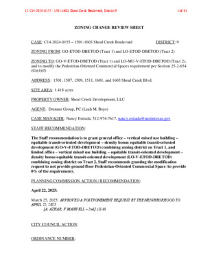
ZONING CHANGE REVIEW SHEET CASE: C14-2024-0155 – 1501-1603 Shoal Creek Boulevard DISTRICT: 9 ZONING FROM: GO-ETOD-DBETOD (Tract 1) and LO-ETOD-DBETOD (Tract 2) ZONING TO: GO-V-ETOD-DBETOD (Tract 1) and LO-MU-V-ETOD-DBETOD (Tract 2), and to modify the Pedestrian-Oriented Commercial Spaces requirement per Section 25-2-654 (G)(4)(f) ADDRESS: 1501, 1507, 1509, 1511, 1601, and 1603 Shoal Creek Blvd. SITE AREA: 1.418 acres PROPERTY OWNER: Shoal Creek Development, LLC AGENT: Drenner Group, PC (Leah M. Bojo) CASE MANAGER: Nancy Estrada, 512-974-7617, nancy.estrada@austintexas.gov STAFF RECOMMENDATION: The Staff recommendation is to grant general office – vertical mixed use building – equitable transit-oriented development – density bonus equitable transit-oriented development (GO-V-ETOD-DBETOD) combining zoning district on Tract 1, and limited office – vertical mixed use building – equitable transit-oriented development – density bonus equitable transit-oriented development (LO-V-ETOD-DBETOD) combining zoning district on Tract 2. Staff recommends granting the modification request to not provide ground floor Pedestrian-Oriented Commercial Space (to provide 0% of the requirement). PLANNING COMMISSION ACTION / RECOMMENDATION: April 22, 2025: March 25, 2025: APPROVED A POSTPONEMENT REQUEST BY THE NEIGHBORHOOD TO APRIL 22, 2025 [A. AZHAR; F. MAXWELL – 2nd] (11-0) CITY COUNCIL ACTION: ORDINANCE NUMBER: 12 C14-2024-0155 - 1501-1603 Shoal Creek Boulevard; District 91 of 41 C14-2024-0155 ISSUES: 2 The site is adjacent to an area of steep slopes of limestone rock overlaying erodible clay material. A rimrock Critical Environmental Feature has been identified along a portion of these slopes. However, the stability of the slope at this site and the potential impact of the proposed development has not been evaluated by the Watershed Protection Department environmental staff. When development is proposed within the standard 150 ft buffer of the rimrock through a site plan or subdivision application, the Watershed Protection Department typically requires a geotechnical report from the applicant and reviews the site plan for compliance with the recommendations of the geotechnical engineer. The Watershed Protection Department does not require analysis of steep, potentially unstable slopes that do not meet the specific criteria of rimrock/bluff Critical Environmental Features. Signatures of adjacent property owners have been submitted in response to the above- referenced rezoning case, opposing a rezoning of the property to anything other than SF-3, GO-ETOD-DBETOD for Tract 1, and LO-ETOD-DBETOD for Tract 2. The petition includes 43.73% of eligible signatures and meets the 20% threshold for a valid petition. Petition materials and comment response forms are located at the end of the Staff report. Please refer to Attachment D. On March 11, 2025, the applicant amended their rezoning application to request GO-V- ETOD-DBETOD for Tract 1 and LO-MU-V-ETOD-DBETOD for Tract 2. The original rezoning application that was submitted by the applicant requested GR-MU-V-ETOD- DBETOD for Tract 1 and LO-MU-ETOD-DBETOD for Tract 2. Please refer to Attachment A. On March 9, 2023, City Council approved Resolution No. 20230309-016 accepting the Equitable Transit-Oriented Development Policy Plan and directing the City Manager regarding next steps for implementation of items intended to benefit the Project Connect Phase 1 Austin Light Rail project. This included development of code amendments to support transit in May of 2024 (Ordinance No. 20240516-005), including creation of the ETOD combining district (restrictions on non-transit supportive uses) and the DBETOD combining district (allowing residential use, and relaxing some development standards including increased height in exchange for income-restricted housing). Properties within one half-mile of the Phase 1 Austin Light Rail alignment and Priority Extensions were included within this overlay, and certain properties were rezoned through a City-initiated process to include the ETOD and DBETOD combining districts. Further, properties rezoned with DBETOD combining district were categorized into Subdistrict 1 (maximum allowable height of 120 feet) or Subdistrict 2 (maximum allowable height of 90 feet), generally based on property distance of ¼-mile or ½-mile from the Phase 1 alignment, respectively. However, that rezoning process did not modify any base district zoning or any combining district zoning, which is the subject of this request. The subject of this request is to add (V) combining district to both tracts of this property, as well as (MU) combining district to Tract 2. 12 C14-2024-0155 - 1501-1603 Shoal Creek Boulevard; District 92 of 41 C14-2024-0155 3 CASE MANAGER COMMENTS: The subject area is approximately 1.418 acres and currently developed with fourteen (14) multifamily dwelling units and two (2) single family dwelling units, located at the northeast corner of Shoal Creek Boulevard and West 15th Street alongside North Lamar Boulevard. Please refer to Exhibits A (Zoning Map) and A-1 (Aerial View). The proposed development consists of one hundred and twenty-four (124) multifamily dwelling units and three (3) single family dwelling units. The applicant is requesting general office – vertical mixed use building – equitable transit- oriented development – density bonus equitable transit-oriented development (GO-V- ETOD-DBETOD) combining zoning district, referred to as Tract 1, and limited office – mixed use – vertical mixed use building – equitable transit-oriented development – density bonus equitable transit-oriented development (LO-MU-V-ETOD-DBETOD) combining zoning district, referred to as Tract 2, and to remain in Subdistrict 2. This would allow a development to include multifamily units requiring an affordable component in areas that support future transit. While the property is well-positioned to support transit options, Shoal Creek Boulevard, classified as a Level 1 street under the Austin Strategic Mobility Plan, does not provide the level of foot traffic or commercial viability typically necessary to sustain pedestrian-oriented uses. Additionally, the property features a significant 27-foot horizontal grade change along Shoal Creek Boulevard, further limiting the feasibility of creating viable pedestrian-oriented commercial spaces. Therefore, the applicant is seeking a modification to the ground floor commercial requirement. A development utilizing the density bonus (ETOD) incentives is permitted with the current base (GO) and (LO) zoning districts, provided it includes an affordability component for residential use in order to obtain incentives. This includes a height maximum of up to 70 feet for the (LO) zoning district (40 feet base district plus up to 30 feet height incentive) and up to 90 feet for the (GO) zoning district (60 feet base district plus up to 30 feet height incentive) and relaxation of development and compatibility standards, such as floor to area ratio (FAR), setbacks and building coverage. There are several methods of satisfying (DBETOD) development affordability requirements, based on whether the proposed units will be offered as rental or for ownership. For rental units, the options are based on a tiered system tied to achievable maximum height or modified development standards. i. To achieve 60 feet in height or to utilize a development standard under DBETOD that is not height-related, a development must provide: • a minimum of 10% of the residential units as affordable for lease and occupancy by households earning 60% or less than the Austin-Round Rock Metropolitan Statistical Area MFI; 12 C14-2024-0155 - 1501-1603 Shoal Creek Boulevard; District 93 of 41 C14-2024-0155 4 ii. To achieve 90 feet in height, a development must provide: • a minimum of 12% of the residential units as affordable for lease and occupancy by households earning 60% or less than the Austin-Round Rock Metropolitan Statistical Area MFI; or • a minimum of 10% of the residential units as affordable for lease and occupancy by households earning 50% or less MFI. There are two options of satisfying (DBETOD) development affordability requirements which include ownership units: 1) 2) a minimum of 12% of the units as affordable for ownership and occupancy by households earning 80% or less than the Austin-Round Rock Metropolitan Statistical Area MFI; or an in-lieu-fee payment to the Housing Trust Fund, equivalent to 125% of the required percentage of the total residential units, including the mix of bedrooms required, at the rate set in the fee schedule at the time of site plan submittal. Staff is recommending (GO-V-ETOD-DBETOD) combining zoning district for Tract 1 and (LO-V-ETOD-DBETOD) combining zoning district on Tract 2, therefore the proposed development will require an affordability component. Staff also recommends granting the modification request to not provide ground floor Pedestrian-Oriented Commercial Space. BASIS OF RECOMMENDATION: 1. The proposed zoning should be consistent with the purpose statement of the district sought. General Office (GO) district is intended for offices and selected commercial uses predominately serving community and city-wide needs. Limited Office (LO) district is intended for offices predominately serving neighborhood or community needs, which may be located within or adjacent to residential neighborhoods. Vertical Mixed Use Building (V) combining district may be applied in combination with any commercial base zoning district and allows for a combination of office, retail, commercial and residential uses within a vertical mixed use building. Equitable Transit-Oriented Development (ETOD) combining district promotes transit- supportive uses, increases bicycle, pedestrian, transit connectivity, and housing options, near public transit, and prohibits certain commercial, industrial, and agricultural uses. Density Bonus Equitable Transit-Oriented Development (DBETOD) combining district allows for residential uses, modifies compatibility standards and site development regulations, and grants additional building height in exchange for income-restricted housing. 12 C14-2024-0155 - 1501-1603 Shoal Creek Boulevard; District 94 of 41 C14-2024-0155 5 2. Zoning should promote clearly identified community goals, such as creating employment opportunities or providing for affordable housing. The proposed rezoning would enable participation in a voluntary density bonus or incentive program, offering modifications to development regulations or other regulatory benefits in exchange for the provision of community benefits. In return for increased development potential, the project must meet the affordable housing requirements as per the (DBETOD) combining district regulations. This request remains consistent with the City’s objectives to promote density and affordability near future transit corridors by allowing more flexible development standards. 3. The rezoning should be consistent with the policies and principles adopted by the City Council. City Council has provided policy and direction for having more residential density and increased affordability and equitable transit-oriented development, as well as incentivizing vertical mixed use buildings throughout the City. EXISTING ZONING AND LAND USES: Site ZONING GO-ETOD-DBETOD; LO-ETOD-DBETOD North GO-ETOD-DBETOD; LO South LO-ETOD-DBETOD; SF-3 East West SF-3; SF-3-H SF-3; P; MF-3 LAND USES Multifamily; Single-family residences Neighborhood office Undeveloped; West 15th Street; Recreation Center/Sports field Single-family residences Shoal Creek Boulevard; North Lamar Boulevard; Public park NEIGHBORHOOD PLANNING AREA: Downtown Austin Plan (Judges Hill District) WATERSHED: Shoal Creek – Urban CAPITOL VIEW CORRIDOR: No SCENIC ROADWAY: No SCHOOLS: Austin Independent School District Bryker Woods Elementary School O Henry Middle School Austin High School 12 C14-2024-0155 - 1501-1603 Shoal Creek Boulevard; District 95 of 41 C14-2024-0155 6 COMMUNITY REGISTRY LIST: Austin Independent School District Austin Lost and Found Pets Austin Neighborhoods Council Central Austin Community Development Corporation City of Austin Downtown Commission Downtown Austin Neighborhood Assn. (DANA) Friends of Austin Neighborhoods Historic Austin Neighborhood Association AREA CASE HISTORIES: Homeless Neighborhood Association Judges Hill Neighborhood Association Neighborhood Empowerment Foundation Preservation Austin SELTexas Save Our Springs Alliance Shoal Creek Conservancy Sierra Club Austin Regional Group NUMBER REQUEST COMMISSION CITY COUNCIL C14-2023-0138 – Enfield SF-3-NP to MF-3-NP To Grant MF-3-NP (2/27/24) SF-3 to LO-MU-CO To Grant LO-MU-CO (9/11/18) SF-3-H to GO-MU-H- CO To Grant GO-MU-H-CO (2/26/19) C14-2018-0072 – 1700 West Avenue C14-2018-0120 – Herbin-Shoe Historic Mixed Use Rezoning RELATED CASES: Approved MF-3-NP as Planning Commission Recommended (4/18/24) Approved LO-MU-CO as Planning Commission Recommended (10/4/18) Approved GO-MU-H-CO as Planning Commission Recommended (3/28/19) The equitable transit-oriented development (ETOD) combining district and density bonus ETOD (DBETOD) combining district were added to the base districts on July 15, 2024 (C20-2023-004). C14-2015-0119 – Previous rezoning case proposing 1.6 acre subject property from SF-3, LO, GO to GO-MU; application amended request to GO-MU-V zoning on 7/18/2016. Application was withdrawn on 1/3/2017. ADDITIONAL STAFF COMMENTS: Comprehensive Planning: Project Name and Proposed Use: 1507 SHOAL CREEK BOULEVARD. C14-2024-0155. Project: 1501-1603 Shoal Creek Boulevard. 1.418 acres from GO-ETOD-DBETOD, LO-ETOD-DBETOD to GO-V-ETOD-DBETOD, LO-MU-V-ETOD-DBETOD. Existing: 14 multifamily units, and single- family units. Proposed: 124 multifamily units (5 stories), and 3 single-family dwelling units. Demolition to be determined. Note that the ETOD Overlay (Ordinance 20240516-005) may apply to 12 C14-2024-0155 - 1501-1603 Shoal Creek Boulevard; District 96 of 41 C14-2024-0155 7 this proposal. The ETOD Overlay Combining District (ETOD) restricts non-transit supportive uses, and the ETOD Density Bonus District (DBETOD) establishes a density bonus program. DBETOD may trigger certain residential and non-residential redevelopment requirements including but not limited to a tiered approach for maximum building height increases and affordability requirements. Site development standards including maximum FAR have the potential to be waived and Compatibility standards may be modified under DBETOD. Also note that this case provides insufficient information to indicate the attainment of certain Complete Community Measures at this time regarding the ETOD Overlay. Yes Y Imagine Austin Decision Guidelines Complete Community Measures * Imagine Austin Growth Concept Map: Located within or adjacent to an Imagine Austin Activity Center, Imagine Austin Activity Corridor, or Imagine Austin Job Center as identified the Growth Concept Map. Names of Activity Centers/Activity Corridors/Job Centers *: • Within Downtown Regional Center; Adjacent to Lamar Boulevard Activity Corridor Y Mobility and Public Transit *: Located within 0.25 miles of public transit stop and/or light rail station. • 0.24 miles to bus stop along N Lamar Blvd Y Mobility and Bike/Ped Access *: Adjoins a public sidewalk, shared path, and/or bike lane. • Sidewalk present at lower edge of property extending to N Lamar Blvd and W 15th St Y Connectivity, Good and Services, Employment *: Provides or is located within 0.50 miles to goods and services, and/or employment center. • Goods and Services present along W 15th St Connectivity and Food Access *: Provides or is located within 0.50 miles of a grocery store/farmers market. Y Connectivity and Education *: Located within 0.50 miles from a public school or university. • 0.36 miles to ACC Rio Grande Campus Y Connectivity and Healthy Living *: Provides or is located within 0.50 miles from a recreation area, park or walking trail. • 0.25 miles to Austin Recreation Center Y Connectivity and Health *: Provides or is located within 0.50 miles of health facility (ex: hospital, urgent care, doctor’s office, drugstore clinic, and/or specialized outpatient care.) 0.44 miles to Medical Clinic along Rio Grande St • Y Housing Choice *: Expands the number of units and housing choice that suits a variety of household sizes, incomes, and lifestyle needs of a diverse population (ex: apartments, triplex, granny flat, live/work units, cottage homes, and townhomes) in support of Imagine Austin and the Strategic Housing Blueprint. Housing Affordability *: Provides a minimum of 10% of units for workforce housing (80% MFI or less) and/or fee in lieu for affordable housing. Mixed use *: Provides a mix of residential and non-industrial uses. Culture and Creative Economy *: Provides or is located within 0.50 miles of a cultural resource (ex: library, theater, museum, cultural center). Culture and Historic Preservation: Preserves or enhances a historically and/or culturally significant site. Creative Economy: Expands Austin’s creative economy (ex: live music venue, art studio, film, digital, theater.) Workforce Development, the Economy and Education: Expands the economic base by creating permanent jobs, especially in industries that are currently not represented in a particular area or that promotes a new technology, and/or promotes educational opportunities and workforce development training. Industrial Land: Preserves or enhances industrial land. Y Not located over Edwards Aquifer Contributing Zone or Edwards Aquifer Recharge Zone 9 Number of “Yes’s” 12 C14-2024-0155 - 1501-1603 Shoal Creek Boulevard; District 97 of 41 C14-2024-0155 Drainage: 8 The developer is required to submit a pre- and post-development drainage analysis at the subdivision and site plan stage of the development process. The City’s Land Development Code and Drainage Criteria Manual require that the Applicant demonstrate through engineering analysis that the proposed development will have no identifiable adverse impact on surrounding properties. Environmental: The site is not located over the Edwards Aquifer Recharge Zone. The site is located in the Shoal Creek Watershed of the Colorado River Basin, which is classified as an Urban Watershed by Chapter 25-8 of the City's Land Development Code. It is in the Desired Development Zone. Zoning district impervious cover limits apply in the Urban Watershed classification. According to floodplain maps there is a floodplain within or adjacent to the project location. Based upon the location of the floodplain, offsite drainage should be calculated to determine whether a Critical Water Quality Zone exists within the project location. Standard landscaping and tree protection will be required in accordance with LDC 25-2 and 25-8 for all development and/or redevelopment. At this time, site specific information is unavailable regarding vegetation, areas of steep slope, or other environmental features such as bluffs, springs, canyon rimrock, caves, sinkholes, and wetlands. This site is required to provide on-site water quality controls (or payment in lieu of) for all development and/or redevelopment when 8,000 s.f. cumulative is exceeded, and on site control for the two-year storm. At this time, no information has been provided as to whether this property has any preexisting approvals that preempt current water quality or Code requirements. PARD – Planning & Design Review: Parkland dedication will be required at the time of subdivision or site plan application for new residential units, per City Code § 25-1-601, as amended. Whether the requirement shall be met with fees in-lieu or dedicated land will be determined using the criteria in City Code Title 25, Article 14, as amended. Should fees in-lieu be required, those fees shall be used toward park investments in the form of land acquisition and/or park amenities within the surrounding area, per the Parkland Dedication Operating Procedures § 14.3.11 and City Code § 25-1-609, as amended. Note that residential units that are certified affordable and income-restricted are exempt from the parkland dedication requirements per City Code § 25-1-601(D)(4). 12 C14-2024-0155 - 1501-1603 Shoal Creek Boulevard; District 98 of 41 C14-2024-0155 9 If the applicant wishes to discuss parkland dedication requirements in advance of site plan or subdivision applications, please contact this reviewer: ann.desanctis@austintexas.gov. At the applicant’s request, PARD can provide an early determination of whether fees in-lieu of land will be allowed. Site Plan: Site plans will be required for any new development other than single-family or duplex residential. Any new development is subject to Subchapter E. Design Standards and Mixed Use. Additional comments will be made when the site plan is submitted. Compatibility Standards The site is subject to compatibility standards due to the proximity/adjacency of SF-3 zoning on the North, East and South side of the triggering property. Reference 25-2-1051, 25-2-1053 Any structure that is located: a. At least 50 feet but less than 75 feet from any part of a triggering property may not exceed 60 feet. b. Less than 50 feet from any part of a triggering property may not exceed 40 feet. Reference 25-2-1061 An on-site amenity, including a swimming pool, tennis court, ball court, or playground, may not be constructed 25 feet or less from the triggering property. Reference 25-2-1062 This tract is already developed, and the proposed zoning change is a footprint within the existing development ETOD A certification letter from the Housing Department is required before filing for a site development permit. DBETOD Subchapter E applies to this site to the extent of conflict Shoal Creek is your Principal Street. 75% of the building frontage will be required to be commercial. Development Standards: No more than two floors may include non-residential uses. Cocktail lounges and performance venues can only be located on the first or second story. 12 C14-2024-0155 - 1501-1603 Shoal Creek Boulevard; District 99 of 41 C14-2024-0155 10 No residential uses may be located below a cocktail lounge or performance venue. Subdistrict 1 building height is limited to a maximum of 60’ over base zoning, up to 120’. Subdistrict 2 building height is limited to a maximum of 30’ over base zoning, up to 90’. This site is adjacent to a site that contains one to three dwelling units and is zoned SF-5 or more restrictive. A compatibility buffer 25’ in width, designed to 25-8-700 and 25-2-653(H) will be required. Any structure that is located less than 50 feet from any part of a triggering property may not exceed 60 feet. Austin Transportation Department – Engineering Review: Assessment of required transportation mitigation, including the potential dedication of right of way and easements and participation in roadway and other multi-modal improvements, will occur at the time of site plan application. The traffic impact analysis for this site is not required, the traffic generated by the proposal does not exceed the thresholds established in the City of Austin Land Development Code. [LDC 25-6-113]. SHOAL CREEK BLVD has sufficient right of way to comply with the Austin Strategic Mobility Plan (ASMP). [LDC 25-6-51 and 25-6-55]. The adjacent street characteristics table is provided below: Name ASMP Classification ASMP Required ROW Existing ROW Existing Pavement Sidewalks Bicycle Route Shoal Creek Boulevard Level 1 – Local Mobility 58 feet 70 feet 28 feet No No Capital Metro (within ¼ mile) Yes A Neighborhood Traffic Analysis (NTA) was required. Please refer to Attachment C. Austin Water Utility: No comments on zoning change. The landowner intends to serve the site with existing City of Austin water utilities. Based on current public infrastructure configurations, it appears that service extension requests (SER) will be required to provide service to this lot. For more information pertaining to the Service Extension Request process and submittal requirements contact the Austin Water SER team at ser@austintexas.gov. 12 C14-2024-0155 - 1501-1603 Shoal Creek Boulevard; District 910 of 41 C14-2024-0155 11 INDEX OF EXHIBITS AND ATTACHMENTS TO FOLLOW: Exhibit A: Zoning Map Exhibit A-1: Aerial Map Attachment A: Applicant’s Amendment Request Letter Attachment B: Applicant’s Summary Letter Attachment C: Zoning Transportation Analysis (ZTA) Attachment D: Valid Petition information Correspondence 12 C14-2024-0155 - 1501-1603 Shoal Creek Boulevard; District 911 of 41 = ( = = SF-3-CO-NP = SF-3-CO-NP ( MF-3-NP ( ( SF-3-CO-NP ! ! ! ! ! ( SF-3-CO-NP ( ( ! ! SF-3-CO-NP = 04-0021 70-193 ( MF-1-CO-ETOD-DBETOD-NP APTS. MF-4-CO-ETOD-DBETOD-NP ! CP-75-56 ( ( MF-4-CO-NP DUPLEX SP-06-0183C.SH ( MF-4-NP APTS. H81-21 MF-4-NP ( H81-019 X E L P - 4 PARKING H81-020 MF-4-NP 84-149RC 81-209 ( LO-NP W 22ND ST MF-4-NP C14-85-002(RCT) LO-H-NP LO-NP MF-4-CO-ETOD-DBETOD-NP PARKING MF-4-CO-NP MF-4-NP APTS. GO-MU-H-NP APTS. GO-MU-H-NP MF-4-NP APTS. SF-3-CO-NP MF-4-CO-ETOD-DBETOD-NP W 21ST ST C14-2009-0129 CS-1-CO-NP SP-04-0588C.SH CONDOS SF-3-CO-NP T S D V A D I ( ( ( ( MF-3-ETOD-DBETOD-NP L P S N B B O R I C14-2007-0262 LO-MU-CO-NP 98-0138 SF-5-NP SF-3-CO-NP SP-99-0246C ( H2007-0013 C14H-2007-0013 SF-3-H-CO-NP OFFICE C14-2007-0262 LO-NP MF-2-CO-NP ( C14H-05-0001 SF-3-CO-NP C14-04-0021 P80-55 ( C14-2016-0100 ( 79-255 ( SF-4A-CO-NP T S F F I L C ( ( C14H-2010-0031 ( C14H-2013-0007 MF-2-H-CO-NP SF-3-CO-NP ( ( SF-3-CO-NP ( ( C14H-06-0038 SF-3-H-CO-NP ( OLD 19TH ST SP-98-0005CS GO-NP ( ( SF-3-H-CO-NP C14H-2017-0039 ( MF-3-ETOD-DBETOD-NP APTS. MF-4-CO-NP C14-2007-0262 CS-CO-NP SP- 98-0092C C14-97-0102(RCT) C14-2011-0100 C14-2021-0010 GO-MU-CO-NP SF-3-H-CO-NP OLD 19TH ST SF-3-CO-NP SP-02-0358C OFFICE GO-CO-ETOD-DBETOD-NP GO-CO-ETOD-DBETOD-NP 80-01 OFFICE GO R I C E C N A V SF-3 W MARTIN LUTHER KING JR BLVD GO-CO-NP E C I F F O I T S L E R B A G N A S GO-MU C14H-81-018(90)TA MF-4-NP LO-NP FRAT. ( MF-4-NP 82-91 LO-NP SP-06-0463C.SH MF-4-NP APTS. CONDOS SP-06-0693C.SH MF-4-NP COOP-APTS 5 0 0 - 7 7 T S L R A E P 81-102 LO-NP GO-NP C14-2007-0262 79-10R CONDOS MF-4-NP 85-027 NO-NP C14-85-027(RCT) OFF. GO-NP CONDOS W 21ST ST APTS. MF-4-NP APTS. H83-09 CONDOS APTS. GO-NP C14-2007-0262 5 0 0 - 4 8 H 7 4 1 0 - 1 0 H GR-CO-NP 9 8 1 - 3 7 . B A H E R R E T N E C GR-H-CO-NP C 9 3 0 -0 3 0 P- S ( APTS. ( MF-4-NP ( LO-NP APTS. MF-4-NP 85-251 APTS. 92-0010 T S E D N A R G O R I CS-NP C14-2007-0262 APTS. 81-68 C14-2007-0262 ( LO-V-ETOD-DBETOD ( C14-2007-0235 ( 82-121RC MF-6-CO-ETOD-DBETOD C14-03-0174 OFFICE GO-V-ETOD-DBETOD C14-2007-0235 79-270 GO-ETOD-DBETOD MF-4-ETOD-DBETOD GO-H-ETOD-DBETOD Y R E C O R G CS APARTMENTS 65-155RC ( DMU-H-ETOD-DBETOD C14H-2009-0035 SF-3-H W 18TH ST 83-213 GO-ETOD-DBETOD APTS. GO MF-3-ETOD-DBETOD LO-H-ETOD-DBETOD O D N O C SF-3 LO-MU-CO-ETOD-DBETOD C14-2013-0104 C14-2018-0072 LO-H-ETOD-DBETOD C14-2010-0035 SP85-18 GO-H-ETOD-DBETOD ( GO-ETOD-DBETOD CONDO GO 6 0 - 2 9 ( ( SF-3 ( ( ( ( C14H-2013-0005 ( C14H-2009-0044 SF-3-H W 17TH ST ( SF-3 C14H-74-004 GO-ETOD-DBETOD OFF. INS. C 0 0 4 -0 7 9 P S LO-H-ETOD-DBETOD C14-79-014 DORMS CS GO-MU GO TRACT 1 LO-ETOD-DBETOD CONDOS SF-3 82-137 CONDOS T S L R A E P ( P -O O C SF-3-H C14H-2010-0012 ( ( ( ( W 18TH ST ( SF-3-H ( ( C14H-2009-0043 ( LO 66-10 H2009-0043 ! ! ( ! ! ( ! ! SF-3 ! ! ! ( ( SF-3-H ( C14H-00-0010 SF-3 66-100 GO-ETOD-DBETOD ! ! ! ! ! ( C14H-2010-0013 SF-3-H ! ! S H O A L C R E E K ! ! B L V D ! ! 59-80 ! C14-06-0016 R81-060 ! 6 1 1 0 ! - ! 6 0 ! ! ! ! ( ( ! ! ! ! ! LO-ETOD-DBETOD ! !! ! PEASE PARK P P A R K W A Y ( ( 85-186 T AIN S ( MF-3 ( ( R R O L ( ( MF-3 ( P K I N G P S B U R Y S T C14H-04-0029 MF-3-H C14H-03-0014 APARTMENTS H03-0014 ( ( MF-3 MF-3 H 0 2-0 0 2 0 E N FIE L MF-3-H C14H-02-0020 ( ( D R D ( ( CP77-09 02-0112 MF-3-NP ( APARTMENTS ( ( MF-3-NP 02-0112 ( ( ( SF-3-NP W 13T H S T MF-2-NP APARTMENTS ( MF-3-NP = MF-3-HD-NP A PA R T M E N T S SF-3-NP ( ( SF-3-NP H93-23 SF-3-H-HD-NP ( T ( ( 91-28 SF-3-HD-NP O S C N A L B SF-3-H-HD-NP APTS. 86-262 P-H-HD-NP ( ( SF-3 ( ( MF-3 ( ( A P A R T M E N T S ( 8 1-4 0 SF-6 78-09 82-132 ( ( ( MF-3 SF-3 D V L B R A M A L N SF-3-NP C14-2023-0138 MF-3-NP SF-3-NP ( ( A P A R T M E N T S MF-3-CO-NP C14H-05-0017 MF-3-NP ( ( ( MF-3-NP AIR H N O L A S SF-3-NP ( ( MF-3-NP ( SF-3-NP GO-NP C14-04-0149.03 SF-3-NP C14-02-0112 SF-3-NP ( MF-4-NP ( SF-3-NP C14-04-0149.27 ( ( MF-4-NP ( SF-3-NP C14-04-0149.02 MF-3-NP D R R O S D WIN T L S IL E H L T S A C H77-23 MF-3-NP APARTMENTS MF-4-HD-NP MF-3-NP ( SF-3-NP ( ( H05-0017 ( 82-147 ( MF-4-NP ( APTS. ( ( GO-NP N LAMAR SB TO W 15TH RAMP K R A P E S U O H P-NP 87-82 72-315 7 7 - 9 7 K R A P E S U O H T R S CS-MU-CO-NP O 04-0149.27 L Y A B OFC. C14-2007-0237 LR-NP P A MF-3-NP GO-NP OFC. R K W A Y C14H-2009-0011 SF-3-H ( C14H-2009-0045 S. T P A C14-69-072 C14-81-218 LO-ETOD-DBETOD CS-ETOD-DBETOD ( ( LO-ETOD-DBETOD W 16TH ST C14-82-136 GO-ETOD-DBETOD OFFICE C14H-06-0015 C14-2018-0120 GO-H-ETOD-DBETOD C14H-89-0022 SF-3 SF-3-H ( ( SF-3-H ( C14H-2015-0013 C14H-2007-0025 ( NO-H-CO-ETOD-DBETOD 91-0079 CHURCH SF-3 GO-ETOD-DBETOD LO-H-ETOD-DBETOD W 15TH ST SF-3-H ( C14H-95-0004 LO-ETOD-DBETOD ! ! ! ! ! ! DMU-CO-ETOD-DBETOD ! TRACT 2 SF-3-H ! LO-H-ETOD-DBETOD H74-3 LO-ETOD-DBETOD SF-3 HOUSE PARK DMU-H-CO-ETOD-DBETOD C14-2013-0087 ( 79-52 C14H-2009-0026 GO-H-ETOD-DBETOD GO-MU-H-CO-ETOD-DBETOD GO-ETOD-DBETOD PARKING ! !! ! T S E D N A R G IO R GO-ETOD-DBETOD CHURCH GO-ETOD-DBETOD CBD-ETOD-DBETOD C14-84-056(RCT) OFF. C14-75-085(RCT) OFF. OFF. C14H-00-2183 C14H-00-2182 H00-2182 H00-2183 C14-2007-0219 MF-4-ETOD-DBETOD DMU-CO-ETOD-DBETOD C14-2020-0035 LO-ETOD-DBETOD ! LO-ETOD-DBETOD OFFICE GO-ETOD-DBETOD OFF. W 14TH ST DMU-CO-ETOD-DBETOD OFF. GO SP-06-0308D OFFICE GO CHURCH GO C14-2022-0011 GO C14-2015-0093 C14-2015-0094 DMU-CO C14-2016-0093 C14-2010-0151 C14-2016-0022 CBD-CO C14-05-0190 APT GO OFF. T S S E C E U N GO-ETOD-DBETOD OFF. OFF. ! GO GO-ETOD-DBETOD ! ! ! ! W 13TH HALF ST ! ! ANTIQUES C14-2022-0080 C17-2022-0152 DMU-CO-ETOD-DBETOD C14-2021-0025 LR-ETOD-DBETOD GO-ETOD-DBETOD OFF. 90-04 C14-2019-0091 C14-2022-0137 GO-ETOD-DBETOD GO-ETOD-DBETOD DMU-CO-ETOD-DBETOD C14-2010-0197 OFF. DMU-CO-ETOD-DBETOD C14-2017-0076 2 5 0 0 - 1 0 W 13TH ST GO-ETOD-DBETOD S C 9 4 0 2 - 0 0 P S GO-H-ETOD-DBETOD OFF. 6 6 0 2 - 9 9 F. F O C14-97-0163 DMU-ETOD-DBETOD C14H-82-009 GO-ETOD-DBETOD C14-01-0052 OFFICE DMU-H-CO-ETOD-DBETOD GO-ETOD-DBETOD 87-82 87-082 CS-1-ETOD-DBETOD MF-4-NP ( C14-05-0013 CS-MU-CO-NP C14-05-0012 ( NO-MU-NP 95-0027 C14-2007-0237 P GR-V-CO-ETOD-DBETOD-NP CS-MU-CO-ETOD-DBETOD-NP CS-ETOD-DBETOD ( T 7 2-2 7 3 E C L T GO-HD-NP S A C W 13TH ST SCHOOL C14-2017-0077 DMU-CO-ETOD-DBETOD SF-3 MF-4-ETOD-DBETOD P RECREATION CENTER C14H-2010-0006 SF-3-H-HD-NP W 11TH ST SF-3-HD-NP = MF-4-HD-NP ( ( 6 9 1 - 3 8 ( ( 74-48 ( CS-MU-V-CO-ETOD-DBETOD-NP ( GO-NP ( A U T O D E A L E R CS-MU-V-CO-NP E IC F F O C14-2007-0237 ( ( T O L R A C S H O A L C R E E K B L V D SHOPPING CENTER B A O L T O H P ACC AUTO CLASS LO-ETOD-DBETOD MF-4-ETOD-DBETOD E V T A S E W CS Y R E K A B W 12TH ST ( ( C14H-77-026 MF-5-CO-NP ( LO-MU-H-CO-HD-NP ( H77-026 MF-4-HD-NP ( ( C14-2007-0201 NPA-2007-0006.01 C14-2019-0151 MF-6-CO-NP CS-MU-CO-NP C14-04-0149.18 C14-2007-0237 CS-MU-CO-NP CS-MU-CO-ETOD-DBETOD-NP W 11TH ST 86-170 DMU-CO-ETOD-DBETOD C14-2020-0052 CS-ETOD-DBETOD P CS DMU-CO C14-2019-0050 C14-2020-0036 CS-ETOD-DBETOD C14-2022-0141 E G E L L O C LR-CO-ETOD-DBETOD GO-ETOD-DBETOD LR-CO-ETOD-DBETOD DMU-CO-ETOD-DBETOD GO-ETOD-DBETOD DMU-CO-ETOD-DBETOD C14-2015-0133 69-128 DMU ± SUBJECT TRACT ! ! ! ! ! ! PENDING CASE ZONING ZONING CASE#: C14-2024-0155 ZONING BOUNDARY EXHIBIT A This product is for informational purposes and may not have been prepared for or be suitable for legal, engineering, or surveying purposes. It does not represent an on-the-ground survey and represents only the approximate relative location of property boundaries. 1 " = 400 ' This product has been produced by the Planning Department for the sole purpose of geographic reference. No warranty is made by the City of Austin regarding specific accuracy or completeness. Created: 10/29/2024 12 C14-2024-0155 - 1501-1603 Shoal Creek Boulevard; District 912 of 41 EXHIBIT A-1 12 C14-2024-0155 - 1501-1603 Shoal Creek Boulevard; District 913 of 41 ATTACHMENT A Lauren Middleton-Pratt Planning Department City of Austin 6310 Wilhelmina Delco Drive Austin, TX 78752 March 11, 2025 Via Electronic Delivery Re: 1501-1603 Shoal Creek Boulevard – Zoning application for the 1.418-acre property located at 1501, 1507, 1509, 1511, 1601, and 1603 Shoal Creek Boulevard, Austin, Travis County, Texas 78701 (the “Property”). Dear Ms. Middleton-Pratt, As representatives of the owner of the Property, we respectfully submit this letter to amend the application currently under review, assigned zoning case no. C14-2024-0155 for the project titled 1501- 1603 Shoal Creek Boulevard, initially submitted on October 11, 2024. The requested zoning is from GO-ETOD-DBETOD and LO-ETOD-DBETOD to GR-MU-V- ETOD-DBETOD (Community Commercial – Mixed Use – Vertical Mixed Use Building – Equitable Transit-Oriented Development – Density Bonus Equitable Transit-Oriented Development), referred to as “Tract 1”, and LO- MU-ETOD-DBETOD (Limited Office – Mixed Use – Equitable Transit-Oriented Development – Density Bonus Equitable Transit-Oriented Development), referred to as “Tract 2”. With this amendment, we would like to amend the requested rezoning from GO-ETOD-DBETOD to GO-V-ETOD-DBETOD (General Office – Vertical Mixed Use Building – Equitable Transit-Oriented Development – Density Bonus Equitable Transit-Oriented Development) on Tract 1 and from and LO-ETOD-DBETOD to LO-MU-V-ETOD-DBETOD (Limited Office – Mixed Use – Vertical Mixed Use Building – Equitable Transit-Oriented Development – Density Bonus Equitable Transit-Oriented Development) on Tract 2. Please let me know if you or your team members require additional information or have any questions. Thank you for your time and attention to this matter. Sincerely, Leah M. Bojo cc: Joi Harden, Planning Department (via electronic delivery) Nancy Estrada, Planning Department (via electronic delivery) Cynthia Hadri, Planning Department (via electronic delivery) 12 C14-2024-0155 - 1501-1603 Shoal Creek Boulevard; District 914 of 41 ATTACHMENT B January 14, 2025 Ms. Lauren Middleton-Pratt Planning Department City of Austin 6310 Wilhelmina Delco Drive Austin, TX 78752 Re: 1501-1603 Shoal Creek Boulevard – Rezoning application for the 1.418-acre property located at 1501, 1507, 1509, 1511, 1601, and 1603 Shoal Creek Boulevard, Austin, Travis County, Texas 78701 (the “Property”). Dear Ms. Middleton-Pratt: As representatives of the owners of the Property, we respectfully submit the enclosed rezoning application package. The submittal is titled 1501-1603 Shoal Creek Boulevard and is approximately 1.418 acres of land, located at the northeast corner of N Lamar Boulevard and the Eastbound 15th Street to Northbound Lamar Ramp. The Property is located within the full purpose jurisdiction of the City of Austin. The Property is currently zoned GO-ETOD-DBETOD (General Office – Equitable Transit-Oriented Development – Density Bonus Equitable Transit-Oriented Development) and LO-ETOD-DBETOD (Limited Office – Equitable Transit-Oriented Development – Density Bonus Equitable Transit-Oriented Development). The requested zoning is from GO-ETOD-DBETOD and LO-ETOD-DBETOD to GR-MU-V- ETOD- DBETOD (Community Commercial – Mixed Use – Vertical Mixed Use Building – Equitable Transit-Oriented Development – Density Bonus Equitable Transit-Oriented Development), referred to as “Tract 1”, and LO- MU-ETOD-DBETOD (Limited Office – Mixed Use – Equitable Transit-Oriented Development – Density Bonus Equitable Transit-Oriented Development), referred to as “Tract 2”. The purpose of this rezoning is to allow for the redevelopment of the Property into a transit-supportive residential use within the Imagine Austin Downtown Regional Center. The Imagine Austin Comprehensive Plan states on pages 104 and 105 that, “Regional Centers are intended to provide increased density of people and jobs through the development of low to high-rise apartments and mixed-use buildings.” This request is supportive of the City of Austin's Strategic Housing Blueprint goal of locating 75% of new housing units within one-half mile of Imagine Austin's Centers & Corridors. We respectfully request to modify the requirement to provide pedestrian-oriented uses along 75% of the building’s principal frontage on Shoal Creek Boulevard to 0%, as permitted by the City’s Land Development Code Section 25-2-654 (G)(4)(f). This request is based on the unique characteristics of the Property and its surrounding context. While the property is well-positioned to support transit options, Shoal Creek Boulevard, classified as a Level 1 street under the Austin Strategic Mobility Plan, does not provide the level of foot traffic or commercial viability typically necessary to sustain pedestrian-oriented uses. Additionally, the property features a significant 27- foot horizontal grade change along Shoal Creek Boulevard, further limiting the feasibility of creating viable 12 C14-2024-0155 - 1501-1603 Shoal Creek Boulevard; District 915 of 41 P a g e | 2 pedestrian-oriented commercial spaces. This modification will allow for a more context-sensitive development approach that aligns with the street's functional and topographical characteristics. The Property is located in the Judges Hill District of the Downtown Austin Plan, which is also identified as a Regional Center within the Imagine Austin Plan. The Downtown Austin Plan does not have a Future Land Use Map (“FLUM”); therefore, a Neighborhood Plan Amendment is not required. The Property is located in a portion of Downtown Austin that is ineligible for participation in the Downtown Density Bonus Program. A neighborhood traffic analysis (NTA) is required with this rezoning request, per the attached TIA Determination waiver dated July 31, 2024 and executed by Mustafa Wali. Please let me know if you or your team members require additional information or have any questions. Thank you for your time and attention to this development. Sincerely, Leah M. Bojo cc: Joi Harden, Planning Department (via electronic delivery) Cynthia Hadri, Planning Department (via electronic delivery) 12 C14-2024-0155 - 1501-1603 Shoal Creek Boulevard; District 916 of 41 ATTACHMENT C MEMORANDUM To: CC: FROM: DATE: SUBJECT: Katie Strain Kaylie Coleman, Matiur Rahman, Bryan Golden Manar Hasan, P.E. February 14, 2025 1507 Shoal Creek Boulevard Neighborhood Traffic Analysis (C14-2024-0155) The proposed development consists of 124 multifamily housing units and 3 single family dwelling units. The site is a 1.418-acre tract on Shoal Creek Boulevard, east of N Lamar Boulevard, as shown in Figure 1 below. This site proposes access to Shoal Creek Boulevard, which is a Level 1 street. The Transportation Development Services (TDS) division has conducted an NTA and offers the following comments. Figure 1: Site Location Roadways Shoal Creek Boulevard: The ASMP designates Shoal Creek Blvd as a Level 1 road. The pavement width of Shoal Creek Blvd along the site frontage is approximately 30 feet. There are two unstriped travel lanes and on street parking with curb and gutter along the site frontage of Shoal Creek Blvd. There is no continuous sidewalk in the vicinity of the site on Shoal Creek Blvd. It functions as a 30- mph street. According to the ASMP, the required right-of-way of Shoal Creek Blvd in the vicinity of the site is 58/64 feet. Page 1 of 3 12 C14-2024-0155 - 1501-1603 Shoal Creek Boulevard; District 917 of 41 Trip Generation and Traffic Analysis Based on the Institute of Transportation Engineer’s Trip Generation Manual, 11th Edition, the proposed development will generate 392 adjusted vehicle trips per day. See Table 1 for a detailed breakdown of the trip generation. Table 1. Trip Generation Land Use ITE Code Existing Units Trip Generation Single-Family Detached Housing Multifamily Housing (Low-Rise) 210 220 2 Dwelling Units 14 Dwelling Units Proposed Single-Family Detached Housing Multifamily Housing (Mid-Rise) 210 221 3 Dwelling Units 124 Condominiums NET TRIPS 28 165 40 545 392 24-hour traffic volumes were collected at two points, see Figure 2 below, on Shoal Creek Blvd on January 14th, 15th, and 16th, 2025. Figure 2: Tube count locations Table 2 provides an assumed trip distribution for the proposed land uses. This development proposes access to Shoal Creek Blvd. It has been assumed 80% of the site traffic will use Shoal Creek Blvd east of N Lamar Blvd to access the site and 20% of the site traffic will use Shoal Creek Blvd north of 15th WB to Lamar NB Ramp to access the site. Page 2 of 3 12 C14-2024-0155 - 1501-1603 Shoal Creek Boulevard; District 918 of 41 Table 2. Trip Distribution Street Expected Trip Distribution (Percentage) Shoal Creek Blvd, East of N Lamar Blvd (Location 1) Shoal Creek Blvd, North of 15th WB to Lamar NB Ramp (Location 2) 80% 20% Table 3 represents a breakdown of traffic on Shoal Creek Blvd: existing traffic, proposed site traffic, and total traffic after development. Table 3. Traffic Summary Adjusted Existing Traffic from Counts (vehicles per day, vpd) Site Traffic added to Roadway (vpd) Total Future Traffic (vpd) 303 119 314 78 617 197 Street Shoal Creek Blvd, East of N Lamar Blvd (Location 1) Shoal Creek Blvd, North of 15th WB to Lamar NB Ramp (Location 2) According to Section 25-6-116 of the Land Development Code (LDC), residential local or collector streets that have between 30 and 40 feet of pavement width are operating at an undesirable level if the average daily traffic volume for such a roadway exceeds 1,800 vehicles per day. Based on the LDC criteria, Shoal Creek Blvd is currently operating at desirable levels and will continue operating at desirable levels with the addition of site traffic. This site will be subject to Street Impact Fee (SIF), which will help fund roadway capacity projects identified in RCP necessitated by new developments. SIF calculation shall be performed during the Site Plan review and fee will be collected at the time of building permit. For SIF-related information, please visit the City’s SIF website (https://www.austintexas.gov/department/street-impact-fee). This assessment is based on the proposed uses and access; any changes in these assumptions may require an updated NTA. This NTA does not grant nor guarantee approval of proposed driveway types or locations. Driveway types and locations will be reviewed with the site plan application. Please contact me at manar.hasan@austintexas.gov if you have questions or require additional information. Sincerely, Manar Hasan, P.E. Transportation and Public Works Department, City of Austin Page 3 of 3 12 C14-2024-0155 - 1501-1603 Shoal Creek Boulevard; District 919 of 41 ATTACHMENT D 12 C14-2024-0155 - 1501-1603 Shoal Creek Boulevard; District 920 of 41 12 C14-2024-0155 - 1501-1603 Shoal Creek Boulevard; District 921 of 41 N L A M A R B L V D V A N C E C I R S H O A L C R E E K B L V D KIN G SB U RY ST Y A W K R A P T L S RIE B A N G A S T L S R A E P W 18TH ST W 17TH ST W 16TH ST W 15TH ST E V T A S E W ± BUFFER PROPERTY_OWNER SUBJECT_TRACT PETITION Case#: C14-2024-0155 This product is for informational purposes and may not have been prepared for or be suitable for legal, engineering, or surveying purposes. It does not represent an on-the-ground survey and represents only the approximate relative location of property boundaries. 1 " = 200 ' This product has been produced by the Planning Department for the sole purpose of geographic reference. No warranty is made by the City of Austin regarding specific accuracy or completeness. 12 C14-2024-0155 - 1501-1603 Shoal Creek Boulevard; District 922 of 41 Case Number: C14-2024-0155 PETITION Total Square Footage of Buffer: Percentage of Square Footage Owned by Petitioners Within Buffer: Date: 3/21/2025 345624.6178 43.73% Calculation: The total square footage is calculated by taking the sum of the area of all TCAD Parcels with valid signatures including one-half of the adjacent right-of-way that fall within 200 feet of the subject tract. Parcels that do not fall within the 200 foot buffer are not used for calculation. When a parcel intersects the edge of the buffer, only the portion of the parcel that falls within the buffer is used. The area of the buffer does not include the subject tract. TCAD ID Address Owner Signature Petition Area Percent 0211010725 1609 SHOAL CREEK BLVD 78701 0112000319 1700 SAN GABRIEL ST AUSTIN 78701 0211010727 903 W 17 ST 78701 0112000401 N LAMAR BLVD 78701 0211010720 SHOAL CREEK BLVD 78701 0211010719 1501 SHOAL CREEK BLVD 78701 0211010601 SHOAL CREEK BLVD 78701 0211010707 W 16 ST 78701 0211010730 W 16 ST 78701 0211010708 903 W 16 ST 78701 0211010703 1604 PEARL ST AUSTIN 78701 0211010726 1001 W 17 ST 78701 0211010704 900 W 16 ST 78701 0211010731 908 W 16 ST 78701 Total AUSTIN EQUITY INVESTORS LTD BLAKESLEE JULIE D & JOHN WILLIAM SHELBY SPONG BRADSHAW ELIZABETH S MORIN CITY OF AUSTIN CITY OF AUSTIN CITY OF AUSTIN CITY OF AUSTIN CITY OF AUSTIN CITY OF AUSTIN GOSSELINK PAUL & MARGARET L KUNZ JOSEPH DAVID LIVING TRUST PRINCE EDWARD RUDOLPH III & CATHERINE CRAFT PRINCE SWANN DENISE TUSCANY TRUST yes yes yes no no no no no no yes yes yes no yes 8327.27 1440.10 39502.24 45279.12 26304.55 50901.63 5078.30 2643.01 17574.89 10.93 42881.52 12.41% 2.41% 0.42% 0.00% 0.00% 0.00% 0.00% 0.00% 0.00% 5.08% 0.00% 36888.54 10.67% 0.00% 44018.03 12.74% 324204.39 43.73% 3354.27 12 C14-2024-0155 - 1501-1603 Shoal Creek Boulevard; District 923 of 41 12 C14-2024-0155 - 1501-1603 Shoal Creek Boulevard; District 924 of 41 12 C14-2024-0155 - 1501-1603 Shoal Creek Boulevard; District 925 of 41 12 C14-2024-0155 - 1501-1603 Shoal Creek Boulevard; District 926 of 41 12 C14-2024-0155 - 1501-1603 Shoal Creek Boulevard; District 927 of 41 12 C14-2024-0155 - 1501-1603 Shoal Creek Boulevard; District 928 of 41 12 C14-2024-0155 - 1501-1603 Shoal Creek Boulevard; District 929 of 41 12 C14-2024-0155 - 1501-1603 Shoal Creek Boulevard; District 930 of 41 12 C14-2024-0155 - 1501-1603 Shoal Creek Boulevard; District 931 of 41 The Tuscany Trust 908 West 16th Sucet Austin, Texas 78701-1504 January 3, 2025 Ms. Lauren Middleton-Pratt City of Austin Planning 6310 Wilhelmina Delco Drive Austin, Department Texas 78752 RE: Cl4-2024-0155 (1501-1603 Shoal Creek Blvd.): Written to Protest Rezoning Dear Ms. Middleton-Pratt: The undersigned Property rezoning hereby pursuant files this written to Section is the owner (the "Owner") of property located ID No. 726994), at 150 I, I 507, 1509, 151 l, 1601, and I 603 Shoal Creek Boulevard being located said property 200 feet within in Austin. The Owner at 908 W. 16th Street (TCAD for of the property proposed protest to the proposed of the Texas Local Government rezoning Code. 21 I .006(d) of 1501-1603 Shoal Creek Boulevard Owner files this objection in conjunction with Owner's neighbors as part of a valid petition. to protesting In addition petition aspects to also preserve of the site plan proposed the proposed the Owner's rezoning, right to protest the Owner files this written the undisclosed protest and therefore and valid unknown for I 501-1603 Shoal Creek Boulevard. Willia Trust establishe e of The Tuscany $ENT BY CERTIFIED MAIL, RETURN RECEIPT REQUF.STED AND COPY BY FIRST CLASS MAIL c: Jackson LLP Walker Attn: Tim Taylor 43 I 26858v.2 12 C14-2024-0155 - 1501-1603 Shoal Creek Boulevard; District 932 of 41 Austin City Council. City Hall 301 West 2nd St Austin, TX 78701 of the following We the undersigned owners (comprised file this objection our neighbors preserve to object our right of property lots: 1501, 1507, 1509, 1511, 1601 and 1603 Shoal Creek Blvd) in conjunction with We file this objection rezoning in order to also application. We file this objection unknown thereby and valid petition to the undisclosed and aspects of the site plan. within 200 feet of the proposed project by Citiscape as part of a valid petition. to Citiscape's e and John Spong abriel St. TX 78701 Austin, 12 C14-2024-0155 - 1501-1603 Shoal Creek Boulevard; District 933 of 41 From: Leah Bojo Sent: Friday, March 21, 2025 4:31 PM To: Paul Gosselink; Estrada, Nancy <Nancy.Estrada@austintexas.gov> Cc: Jim Montgomery; Drew Raffaele Subject: Re: Shoal creek External Email - Exercise Caution Hi Paul, I just got off the phone with my client and we can agree to your request to postpone Planning Commission to 4/22 due to your conflict on 4/8. That said, we would expect the City Council hearing to be scheduled for 5/22, with 6/5 as the backup date, doing everything we can to ensure that this case is done before Council heads into the summer break. I think that’s what we talked about, but I wanted to make it super clear. Thanks to you and Jim for meeting this afternoon to discuss all of this. Leah M. Bojo, AICP, Director of Land Use & Entitlements 2705 Bee Caves Road, Suite 100, Austin, TX 78746 Drenner Group, PC | www.drennergroup.com From: Paul Gosselink Date: Friday, March 21, 2025 at 4:58 PM To: Nancy Estrada <Nancy.Estrada@austintexas.gov> Cc: Leah Bojo, Jim Montgomery Subject: Shoal creek Nancy - I want to report that Leah and I just finished our call. Among other things, we agreed that our case should be postponed from its presently scheduled date of 3/25. Leah and I agreed that it should be postponed until 4/22 subject to Leah getting approval from her client which she said she would advocate. We further agreed based on what we know now that we would agree that we would appear before Council on the zoning portion of this application by 6/5. My caveat was that if something unforeseen/surprising came up we would not be bound to a 6/5 date. Hope this helps. I also understand from Leah that the staff report has been issued. Please send me a copy if you have not already. Paul 12 C14-2024-0155 - 1501-1603 Shoal Creek Boulevard; District 934 of 41 To the Austin Planning Commissioners In care of Ella.Garcia@austin texas.gov Public Safety Risks Presented by Shoal Creek Development Case # C14-2024-0155 1501-1603 Shoal Creek Boulevard Introduction The City Council will be called upon to consider the application of Citiscape to rezone the referenced property to allow the construction of a condominium/apartment project in the woods at this address. The applicant fails to identify a critical environmental feature (CEF) that must be considered at every stage of the review process due to the significant public safety risk it poses. Request for Action We request that this risk to public safety be considered in the public forum of a City Council meeting. Transparent public dialogue is appropriate in this case in light of the multiple slope collapses that have recently occurred in the nearby area. It is time for the City Council to realize that this problem requires policy direction, or the public safety and property damage problems will continue. Valid Petition The surrounding homeowners have filed a verified valid petition. These property owners and the Judges Hill Neighborhood Assn (JHNA) oppose the project as presently proposed. The principal basis for our opposition is the very real risk that the slope between the project and the homes on top of the surrounding hill will collapse, much like the recent collapses along Lamar Blvd at Wooldridge Dr and 910 Poplar St. This would damage our homes, make them potentially unsaleable or, worse, cause our homes to slide down the collapsed slope. The geologic features (Buda Limestone overlying Del Rio Clays) are the same geologic features found up and down Lamar Blvd. These features led to the collapse of the apartments at Barton Springs and Lamar, the "graffiti wall" project at 11th, and other sites. The confirmed canyon rimrock Critical Environmental Feature (CEF) on the steep slope between the project and our homes is the specific reason for our belief that the proposed project will result in the collapse of this slope. The applicant’s, (Citiscape) present plans are to excavate the toe of this slope to construct a 3-level underground 12 C14-2024-0155 - 1501-1603 Shoal Creek Boulevard; District 935 of 41 parking garage, which will trigger the collapse. Public Safety Concern We bring this issue to the attention of the Council at this time and in this manner because we are concerned that it may be our only opportunity to do so. The Council needs to be informed of the Critical Environmental Feature (CEF) involved in this decision. Stated alternatively, Councilmembers should never be put in a position where, after they act, they discover that they would have acted differently if they had been fully informed. The risk to public safety is so clear in this case that the Council must consider this risk in addition to the standard zoning factors when considering our valid petition. Regulatory Violations The presently proposed location of Citiscape's project significantly violates the 150-foot buffer between the CEF and the proposed project as set out in the Environmental Criteria Manual (ECM). The Council's recognition of the importance of adhering to the buffer requirements established by the ECM and Land Development Code (LDC) was recently reiterated by the Council's approval in March of the requirement to conduct hazard zone analyses within 200 feet of a waterway. Moreover, none of the other requirements of Section 25-8-121 of the LDC have been provided, making the Citiscape project application incomplete. Indeed, there is no mention of the existence of the CEF in any application documents on file. Expert Opinion Our concern that our homes will be damaged or slide down the slope when it collapses can be easily demonstrated. We have prepared various slides that explain the geotechnical engineering basis for our concern. We have retained Dr. Robert Gilbert, Chair of the Department of Civil, Architectural, and Environmental Engineering in the UT Cockrell School of Engineering. Professor Gilbert has studied this specific stretch of Shoal Creek’s geology for over 30 years and is familiar with multiple examples of similar slope failures nearby. He will explain that Citiscape's plan to excavate the toe of this slope to construct a 3-level underground parking garage will trigger the collapse. Please include this memo in the agenda backup material for the Planning Commission and the Council. 12 C14-2024-0155 - 1501-1603 Shoal Creek Boulevard; District 936 of 41 Sincerely, Sally and Mike Ward 901 West 16th Street, Austin TX 78701 Judges Hill 12 C14-2024-0155 - 1501-1603 Shoal Creek Boulevard; District 937 of 41 910 Poplar Street above east side of Lamar Wooldridge Drive on west side of Lamar CAUTION: This is an EXTERNAL email. Please use caution when clicking links or opening attachments. If you believe this to be a malicious or phishing email, please report it using the "Report Message" button in Outlook. For any additional questions or concerns, contact CSIRT at "cybersecurity@austintexas.gov". 12 C14-2024-0155 - 1501-1603 Shoal Creek Boulevard; District 938 of 41 To the Austin Planning Commissioners care of Ella.Garcia@austin texas.gov Public Safety Risks Presented by Shoal Creek Development Case # C14-2024-0155 1501-1603 Shoal Creek Boulevard Introduction The City Council will be called upon to consider the application of Citiscape to rezone the referenced property to allow the construction of a condominium/apartment project in the woods at this address. The applicant fails to identify a critical environmental feature (CEF) that must be considered at every stage of the review process due to the significant public safety risk it poses. Request for Action I request that this risk to public safety be considered in the public forum of a City Council meeting. Transparent public dialogue is appropriate in this case in light of the multiple slope collapses that have recently occurred in the nearby area. It is time for the City Council to realize that this problem requires policy direction, or the public safety and property damage problems will continue. Valid Petition The surrounding homeowners have filed a verified valid petition. These property owners and the Judges Hill Neighborhood Assn (JHNA) oppose the project as presently proposed. The principal basis for our opposition is the very real risk that the slope between the project and the homes on top of the surrounding hill will collapse, much like the recent collapses along Lamar Blvd at Wooldridge Dr and 910 Poplar St. This would damage our homes, make them potentially unsaleable or, worse, cause our homes to slide down the collapsed slope. The geologic features (Buda Limestone overlying Del Rio Clays) are the same geologic features found up and down Lamar Blvd. These features led to the collapse of the apartments at Barton Springs and Lamar, the "graffiti wall" project at 11th, and other sites. The confirmed canyon rimrock Critical Environmental Feature (CEF) on the steep slope between the project and our homes is the specific reason for our belief that the proposed project will result in the collapse of this slope. The applicant’s, (Citiscape) present plans are to excavate the toe of this slope to construct a 3-level underground 12 C14-2024-0155 - 1501-1603 Shoal Creek Boulevard; District 939 of 41 parking garage, which will trigger the collapse. Public Safety Concern I bring this issue to the attention of the Council at this time and in this manner because I am concerned that it may be our only opportunity to do so. The Council needs to be informed of the Critical Environmental Feature (CEF) involved in this decision. Stated alternatively, Councilmembers should never be put in a position where, after they act, they discover that they would have acted differently if they had been fully informed. The risk to public safety is so clear in this case that the Council must consider this risk in addition to the standard zoning factors when considering our valid petition. Regulatory Violations The presently proposed location of Citiscape's project significantly violates the 150-foot buffer between the CEF and the proposed project as set out in the Environmental Criteria Manual (ECM). The Council's recognition of the importance of adhering to the buffer requirements established by the ECM and Land Development Code (LDC) was recently reiterated by the Council's approval in March of the requirement to conduct hazard zone analyses within 200 feet of a waterway. Moreover, none of the other requirements of Section 25-8-121 of the LDC have been provided, making the Citiscape project application incomplete. Indeed, there is no mention of the existence of the CEF in any application documents on file. Expert Opinion My concern that our homes will be damaged or slide down the slope when it collapses can be easily demonstrated. We have prepared various slides that explain the geotechnical engineering basis for our concern. We have retained Dr. Robert Gilbert, Chair of the Department of Civil, Architectural, and Environmental Engineering in the UT Cockrell School of Engineering. Professor Gilbert has studied this specific stretch of Shoal Creek’s geology for over 30 years and is familiar with multiple examples of similar slope failures nearby. He will explain that Citiscape's plan to excavate the toe of this slope to construct a 3-level underground parking garage will trigger the collapse. Please include this memo in the agenda backup material for the Planning Commission and the Council. Sincerely, Piper Jones Judges Hill 12 C14-2024-0155 - 1501-1603 Shoal Creek Boulevard; District 940 of 41 12 C14-2024-0155 - 1501-1603 Shoal Creek Boulevard; District 941 of 41