06 NPA-2024-0019.01 Red River; District 9 Staff Report — original pdf
Backup
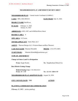
Planning Commission: February 11, 2025 NEIGHBORHOOD PLAN AMENDMENT REVIEW SHEET NEIGHORHOOD PLAN: Central Austin Combined (CANPAC) CASE#: NPA-2024-0019.01 DATE FILED: July 25, 2024 PROJECT NAME: Red River PC DATE: February 11, 2025 January 28, 2025 ADDRESS/ES: 4305, 4307, and 4309 Red River Street DISTRICT AREA: 9 SITE AREA: 0.35 acres OWNER/APPLICANT: Sierra Halo, LLC AGENT: Thrower Design, LLC (Victoria Haase and Ron Thrower) CASE MANAGER: Maureen Meredith PHONE: (512) 974-2695) STAFF EMAIL: Maureen.Meredith@austintexas.gov TYPE OF AMENDMENT: Change in Future Land Use Designation From: Single Family To: Neighborhood Mixed Use Base District Zoning Change Related Zoning Case: C14-2024-0121 From: SF-3-NP To: LR-MU-DB90-NP NEIGHBORHOOD PLAN ADOPTION DATE: August 26, 2024 CITY COUNCIL DATE: TBD ACTION: PLANNING COMMISSION RECOMMENDATION: February 11, 2025 - (action pending) Page 1 of 32 06 NPA-2024-0019.01 - Red River; District 9 1 of 32 Planning Commission: February 11, 2025 January 28, 2025 - Postponed to February 11, 2025 on the consent agenda at the request of the applicant. [R. Johnson 1st: F. Maxwell – 2nd] Vote: 11-0 [G. Anderson and A. Woods absent. F. Maxwell abstained from Item #11]. STAFF RECOMMENDATION: Staff supports the applicant’s request for Neighborhood Mixed Use land use. BASIS FOR STAFF’S RECOMMENDATION: Staff supports the applicant’s request for Neighborhood Mixed Use land use because the property is located on Red River Street which has a mix of land uses. The property is near public transportation and could provide additional housing units for the City. Below are section of the Central Austin Combined Neighborhood Plan. The Central Austin Combined Neighborhood Plan supports the preservation of single family homes in the planning area and within the Hancock area, but due to the City’s housing needs, this proposed development could provide addtinal housing units along a commercial corridor in proximity to public transporation and within walking distance from commerical uses. Page 2 of 32 06 NPA-2024-0019.01 - Red River; District 9 2 of 32 Planning Commission: February 11, 2025 Page 3 of 32 06 NPA-2024-0019.01 - Red River; District 9 3 of 32 Planning Commission: February 11, 2025 LAND USE DESCRIPTIONS: EXISTING LAND USE: Single family - Single family detached or up to three residential uses at typical urban and/or suburban densities. Purpose 1. Preserve the land use pattern and future viability of existing neighborhoods; 2. Encourage new infill development that continues existing neighborhood patterns of development; and 3. Protect residential neighborhoods from incompatible business or industry and the loss of existing housing. Application 1. Existing single‐family areas should generally be designated as single family to preserve established neighborhoods; and 2. May include small lot options (Cottage, Urban Home, Small Lot Single Family) and two‐family residential options (Duplex, Secondary Apartment, Single Family Attached, Two‐Family Residential) in areas considered appropriate for this type of infill development. PROPOSED LAND USE: scale retail or offices, professional services, convenience retail, and Neighborhood Mixed Use - An area that is appropriate for a mix of neighborhood commercial (small shopfront retail that serve a market at a neighborhood scale) and small to medium residential uses. Purpose 1. Accommodate mixed use development in areas appropriate for a mix of residential uses density ‐ ‐ and neighborhood commercial uses that serve surrounding neighborhoods; and 2. Provide transition from residential use to high intensity commercial or mixed use. Application 1. Appropriate for areas such as minor arterials and collectors, small parcels along major family residential development, and areas in environmentally arterials that abut single sensitive zones where high intensity commercial uses are discouraged; and ‐ Page 4 of 32 06 NPA-2024-0019.01 - Red River; District 9 4 of 32 Planning Commission: February 11, 2025 2. May be used as a transition from high intensity commercial and residential uses to single family residential uses. ‐ Yes Yes station. Imagine Austin Decision Guidelines Complete Community Measures Imagine Austin Growth Concept Map: Located within or adjacent to an Imagine Austin Activity Center, Imagine Austin Activity Corridor, or Imagine Austin Job Center as identified the Growth Concept Map. Name(s) of Activity Center/Activity Corridor/Job Center: • Approx. 0.34 miles from Airport Blvd, an activity corridor Yes Mobility and Public Transit: Located within 0.25 miles of public transit stop and/or light rail • Bus routes along Red River Street, E. 45th Street and Airport Blvd. Yes Mobility and Bike/Ped Access: Adjoins a public sidewalk, shared path, and/or bike lane. • Sidewalks and bike lanes along Red River Street. Yes Connectivity, Good and Services, Employment: Provides or is located within 0.50 miles to goods and services, and/or employment center. • The property is within walking distance from Hancock Shopping Center Yes Connectivity and Food Access: Provides or is located within 0.50 miles of a grocery store/farmers market. • 0.3 miles from Hancock Shopping Center with HEB Yes Connectivity and Education: Located within 0.50 miles from a public school or university. • 443 feet from Odessey School (non-profit) Yes Connectivity and Healthy Living: Provides or is located within 0.50 miles from a recreation area, park or walking trail. • 0.4 miles from Hancock Recreation Center No Connectivity and Health: Provides or is located within 0.50 miles of health facility (ex: hospital, urgent care, doctor’s office, drugstore clinic, and/or specialized outpatient care.) • 1.1 miles from St. David’s Medical Center Yes Housing Affordability: Provides a minimum of 10% of units for workforce housing (80% MFI or less) and/or fee in lieu for affordable housing. • The proposed zoning is LR-MU-DB90-NP. If DB90 is pursued, affordable units will be required. Yes Housing Choice: Expands the number of units and housing choice that suits a variety of household sizes, incomes, and lifestyle needs of a diverse population (ex: apartments, triplex, granny flat, live/work units, cottage homes, and townhomes) in support of Imagine Austin and the Strategic Housing Blueprint. • The proposed zoning is LR-MU-DB90-NP. If DB90 or MU is pursued, housing units would be provided. Yes Mixed use: Provides a mix of residential and non-industrial uses. • The proposed zoning is LR-MU-DB90-NP. The proposed zoning would allow for a mixed-use development No No Not known Culture and Creative Economy: Provides or is located within 0.50 miles of a cultural resource (ex: library, theater, museum, cultural center). Culture and Historic Preservation: Preserves or enhances a historically and/or culturally significant site. Creative Economy: Expands Austin’s creative economy (ex: live music venue, art studio, film, digital, theater.) Page 5 of 32 06 NPA-2024-0019.01 - Red River; District 9 5 of 32 Planning Commission: February 11, 2025 Not known Workforce Development, the Economy and Education: Expands the economic base by creating permanent jobs, especially in industries that are currently not represented in particular area or that promotes a new technology, and/or promotes educational opportunities and workforce development training. Industrial Land: Preserves or enhances industrial land. Number of “Yeses” Proximity to Imagine Austin Activity Centers and Corridors Page 6 of 32 No 10 06 NPA-2024-0019.01 - Red River; District 9 6 of 32 Planning Commission: February 11, 2025 Proximity to Public Transportation Page 7 of 32 06 NPA-2024-0019.01 - Red River; District 9 7 of 32 Planning Commission: February 11, 2025 Proximity to Public Parks IMAGINE AUSTIN GROWTH CONCEPT MAP Definitions Neighborhood Centers - The smallest and least intense of the three mixed-use centers are neighborhood centers. As with the regional and town centers, neighborhood centers are walkable, bikable, and supported by transit. The greatest density of people and activities in neighborhood centers will likely be concentrated on several blocks or around one or two intersections. However, depending on localized conditions, different neighborhood centers can be very different places. If a neighborhood center is designated on an existing commercial area, such as a shopping center or mall, it could represent redevelopment or the addition of housing. A new neighborhood center may be focused on a dense, mixed-use core surrounded by a mix of housing. In other instances, new or redevelopment may occur incrementally and concentrate people and activities along several blocks or around one or two intersections. Neighborhood centers will be more locally focused than either a regional or a town center. Businesses and services—grocery and department stores, doctors and dentists, shops, branch libraries, dry cleaners, hair salons, schools, restaurants, and other small and local businesses—will generally serve the center and surrounding neighborhoods. Page 8 of 32 06 NPA-2024-0019.01 - Red River; District 9 8 of 32 Planning Commission: February 11, 2025 Town Centers - Although less intense than regional centers, town centers are also where many people will live and work. Town centers will have large and small employers, although fewer than in regional centers. These employers will have regional customer and employee bases, and provide goods and services for the center as well as the surrounding areas. The buildings found in a town center will range in size from one-to three-story houses, duplexes, townhouses, and rowhouses, to low-to midrise apartments, mixed use buildings, and office buildings. These centers will also be important hubs in the transit system. Regional Centers - Regional centers are the most urban places in the region. These centers are and will become the retail, cultural, recreational, and entertainment destinations for Central Texas. These are the places where the greatest density of people and jobs and the tallest buildings in the region will be located. Housing in regional centers will mostly consist of low to high-rise apartments, mixed use buildings, row houses, and townhouses. However, other housing types, such as single-family units, may be included depending on the location and character of the center. The densities, buildings heights, and overall character of a center will depend on its location. Activity Centers for Redevelopment in Sensitive Environmental Areas - Five centers are located over the recharge or contributing zones of the Barton Springs Zone of the Edwards Aquifer or within water-supply watersheds. These centers are located on already developed areas and, in some instances, provide opportunities to address long-standing water quality issues and provide walkable areas in and near existing neighborhoods. State-of-the-art development practices will be required of any redevelopment to improve stormwater retention and the water quality flowing into the aquifer or other drinking water sources. These centers should also be carefully evaluated to fit within their infrastructural and environmental context. Job Centers - Job centers accommodate those businesses not well-suited for residential or environmentally- sensitive areas. These centers take advantage of existing transportation infrastructure such as arterial roadways, freeways, or the Austin-Bergstrom International airport. Job centers will mostly contain office parks, manufacturing, warehouses, logistics, and other businesses with similar demands and operating characteristics. They should nevertheless become more pedestrian and bicycle friendly, in part by better accommodating services for the people who work in those centers. While many of these centers are currently best served by car, the growth Concept map offers transportation choices such as light rail and bus rapid transit to increase commuter options. Corridors - Activity corridors have a dual nature. They are the connections that link activity centers and other key destinations to one another and allow people to travel throughout the city and region by bicycle, transit, or automobile. Corridors are also characterized by a variety of activities and types of buildings located along the roadway — shopping, restaurants and cafés, parks, schools, single-family houses, apartments, public buildings, houses of worship, mixed-use buildings, and offices. Along many corridors, there will be both large and small redevelopment sites. These redevelopment opportunities may be continuous along stretches of the corridor. There may also be a series of small neighborhood centers, connected by the roadway. Other corridors may have fewer redevelopment Page 9 of 32 06 NPA-2024-0019.01 - Red River; District 9 9 of 32 Planning Commission: February 11, 2025 opportunities, but already have a mixture of uses, and could provide critical transportation connections. As a corridor evolves, sites that do not redevelop may transition from one use to another, such as a service station becoming a restaurant or a large retail space being divided into several storefronts. To improve mobility along an activity corridor, new and redevelopment should reduce per capita car use and increase walking, bicycling, and transit use. Intensity of land use should correspond to the availability of quality transit, public space, and walkable destinations. Site design should use building arrangement and open space to reduce walking distance to transit and destinations, achieve safety and comfort, and draw people outdoors. BACKGROUND: The applicant proposes to change the land use on the future land use map from Single Family to Neighborhood Mixed Use. The applicant states the proposed rezoning would allow for a small, in-fill mixed use development and would allow for more residential units than could be built than under the existing SF-3-NP zoning. The applicant proposes to change the zoning on the property from SF-3-NP (Family Residence District – Neighborhood Plan) to LR-MU-DB90-NP (Neighborhood Mixed Use district – Mixed Use combining district – Density Bonus 90 combining district – Neighborhood Plan). For more information on the proposed zoning, see case report C14- 2024-0121. PUBLIC MEETINGS: The ordinance-required plan amendment meeting was virtually held on September 30, 2024. Approximately 231 community meeting notices were mailed to people with utility accounts or own property within 500 feet of the subject tracts, in addition to neighborhood and environmental groups who requested notification for the area. The recorded meeting can be viewed here: https://publicinput.com/neighborhoodplanamendmentcases. Two city staff members from the Planning Department attended, Maureen Meredith and Mark Walters. Victoria Haase and Ron Thrower from Thrower Design, LLC attended, who are the applicant’s agents, and three people from the neighborhood attended. Below are highlights from Victoria Haase’s presentation: • There are three existing homes on the property and all three are in poor condition, so there is a desire to redevelop the property. • There is a new pedestrian walkway installed across from the properties. • The properties are near Hancock Shopping Center. • The lots total 0.35 acres. • The FLUM request is from Single Family to Neighborhood Mixed Use. • The proposed rezoning is from SF-3-NP to LR-MU-DB90-NP. There could be six small homes built under the HOME Ord. with the existing zoning. • Under DB90, it allows an additional 30 feet in height, with LR at 40 feet, it could be up to 70 feet in height under LR-MU-DB90. With the additional height, more units can be built under DB90, also due to reduced setbacks and the FAR goes away. Page 10 of 32 06 NPA-2024-0019.01 - Red River; District 9 10 of 32 Planning Commission: February 11, 2025 Q: What is the intended use with the rezoning? A: The owners are looking at the possibly of townhouse units, or it could be live/work units or a small commercial development with few residential uses above. There are no concrete plans at this time. Q: Is there any project like you describe already in the neighborhood? A: I can’t think of any off the top of my head, but this is a good location for this type of project where people can walk to. The properties are on the edge of the block and front onto Red River Street, which also has commercial uses and single family along the corridor. There is eclectic mix of uses. Red River Street is a busy roadway that serves as a higher capacity road, it makes sense to have small-scale commercial/mixed uses along the corridor. There’s a lot of mixed use zoning along the corridor already. Q: Will there be parking provided for this proposed new development? A: Yes, there will always be a market demand for parking, even though the City removed minimum parking requirements. Q: Is this a typical development for the owner? A: He doesn’t plan to develop the property himself but would like to a rezone the property so a developer can create a good project. Q: If this gets rezoned, will the neighborhood have input at that point, to get more details on what will be developed? A: You will get a Notice of Filing when a site plan is submitted. You can register as an interested parties for the review process. Page 11 of 32 06 NPA-2024-0019.01 - Red River; District 9 11 of 32 Planning Commission: February 11, 2025 Applicant’s Summary Letter Page 12 of 32 06 NPA-2024-0019.01 - Red River; District 9 12 of 32 Planning Commission: February 11, 2025 Page 13 of 32 06 NPA-2024-0019.01 - Red River; District 9 13 of 32 Letter of Recommendation from the Neighborhood Plan Contact Team (NPCT) Planning Commission: February 11, 2025 Page 14 of 32 06 NPA-2024-0019.01 - Red River; District 9 14 of 32 Letter of Recommendation from Neighborhood Association(s) Planning Commission: February 11, 2025 Page 15 of 32 06 NPA-2024-0019.01 - Red River; District 9 15 of 32 Planning Commission: February 11, 2025 Victoria Haase’s presentation from the September 30, 2024 virtual community meeting Page 16 of 32 06 NPA-2024-0019.01 - Red River; District 9 16 of 32 Planning Commission: February 11, 2025 Page 17 of 32 06 NPA-2024-0019.01 - Red River; District 9 17 of 32 Planning Commission: February 11, 2025 Page 18 of 32 06 NPA-2024-0019.01 - Red River; District 9 18 of 32 Planning Commission: February 11, 2025 Page 19 of 32 06 NPA-2024-0019.01 - Red River; District 9 19 of 32 Planning Commission: February 11, 2025 Site Page 20 of 32 06 NPA-2024-0019.01 - Red River; District 9 20 of 32 Planning Commission: February 11, 2025 Page 21 of 32 06 NPA-2024-0019.01 - Red River; District 9 21 of 32 Planning Commission: February 11, 2025 Page 22 of 32 06 NPA-2024-0019.01 - Red River; District 9 22 of 32 Planning Commission: February 11, 2025 Page 23 of 32 06 NPA-2024-0019.01 - Red River; District 9 23 of 32 Planning Commission: February 11, 2025 Page 24 of 32 06 NPA-2024-0019.01 - Red River; District 9 24 of 32 Planning Commission: February 11, 2025 Correspondence Received From: Barbara Epstein Sent: Wednesday, October 16, 2024 9:53 AM To: Meredith, Maureen <Maureen.Meredith@austintexas.gov> Subject: 4305, 4307, and 4309 Red River St. re-zoning application Dear Ms. Meredith: Somehow the September 30th community meeting about this re-zoning ase fell off my calendar/radar and I did not attend the meeting as the neighborhood association president. I would still like to put in my feedback and learn what happened at the meeting so that our neighborhood can take a vote before the city takes formal action on the case. To date, my understanding is that this is just speculative re-zoning, that there are no definite plans and no assessment of the effect such development would have on traffic flow, emergency vehicle access or future mass transit plans for Red River St., such as the Yellow Line, much less the impact on surrounding modest, affordable, homes. If you have specific information on what happened at the meeting and what information has been submitted, please let me know. Sincerely, Barbara Epstein From: Barbara Epstein Sent: Monday, November 25, 2024 1:42 PM To: Meredith, Maureen <Maureen.Meredith@austintexas.gov> Subject: re: the re-zoning application for 4305, 4307 and 4309 Red river St. Dear Ms. Meredith— I also want to note for the record that the Hancock Neighborhood Association’s efforts to communicate with the owners of the property went unanswered. Contrary to the presentation of their agent, neighbors report that the houses currently there are far from irreparable, they are currently rented, and one has a For Rent sign out front. The association vote to oppose this application was taken because the facts for demolishing existing affordable housing were not presented, and with no development plan presented, there appears to be no benefit whatsoever for the neighborhood. This up-zoning also presents extremely poor planning scenarios, especially for traffic flow on a fairly narrow street, which will already be Page 25 of 32 06 NPA-2024-0019.01 - Red River; District 9 25 of 32 Planning Commission: February 11, 2025 overburdened by projects already approved in the immediate area, along I-35 between 32nd st. and 39th St., as well as the anticipated construction on I-35. Barbara Epstein President Hancock Neighborhood Association Dear Sirs: I’m going to take off my neighborhood association president hat now and write to you just as someone who’s lived here for fifty years and been involved in neighborhood issues since the mid-1980s. Residents’ concerns not only deserve to be heard at the Planning Commission, but for your commission to be impartial, our views must be given the weight as any investor’s. After all, we live here, we pay taxes, and we suffer the consequences of what you approve if investors merely pocket their profits. I’ve laid awake at night, wondering what I could possibly say to you that would have any impact on your decision to re-zone 4305, 4307 and 4309 Red River St., based on your decisions in the past year, cases that not only were not good planning decisions, but which have probably permanently harmed my neighborhood. I decided that I needed to send you a letter and ask that it be included in the record. Two cases that you decided this past year will already have a fundamental negative impact on our neighborhood. One unique architectural reminder of our history has been erased with its demolition, another may well disappear, and with it, a daily link to history that Austin claims to support preserving, but has consistently ignored in Hancock. First, there was the demolition of the 1925 house on Sparks Ave. that our own city had recommended for the National Register of Historic Places, 71 neighbors signed letters supporting its preservation, but you gave the demolition green light to the absentee owner of this 12th neighborhood property acquisition--an owner who refused to even test it for asbestos and lead—and then the city refused to test accumulated rainwater in the hole left behind by the demolition company----even though the property sits on the edge of Eastwoods Park (and the Waller Creek watershed), the last remnant of Wheeler’s Grove, where Austin’s African-American community was first allowed to celebrate Juneteenth. Then, there are the five units on Duval St. on the site of the farm that Sam Houston sold to a survivor of the Alamo. You gave the green light again to an absentee investor to up-zone the property (which could include complete demolition), even though the owner’s dilemma resulted from a lack of due diligence to learn that two units were illegal when he purchased the property, even though he could have just Page 26 of 32 06 NPA-2024-0019.01 - Red River; District 9 26 of 32 Planning Commission: February 11, 2025 subdivided the lot, even though it was pointed out to you that the property is on the corner of Harris Ave. where a bus stop lets children off to walk to Lee Elementary. Maximum development could endanger those children because neighbors already complain that impatient drivers routinely speed up when they turn off Duval St and Red River St. onto Harris Ave. What was the owner’s response to our overtures to come up with a satisfactory solution for both him and the neighborhood?---that it was none of our business what he does, that he wanted to keep all his options open------ and wasn’t interested in providing affordable housing with any increased development. That bus stop brings up the question why the city would give us signs to promote traffic calming, ----when one side of the sign said Look Out for Our Children---but the other side said---Your Speed, Your Choice. ?! The application before you now to up-zone 4305, 4307, and 4309 Red River St. as well as change the neighborhood plan will disrupt and harm our neighborhood much more than the previous two cases because it consists of little to no planning whatsoever, only up-zoning to benefit an owner who actually lives in the neighborhood. The only contact we have had with the owners was one email claiming that the three modest houses currently on the property were in such disrepair that they can only be demolished. There was a preliminary call in late June, 2024, with the applicant’s agent, the email from the owner I submitted to you from August, 2024, an online Community meeting on September 30, 2024, that the owners did not attend, and neither their representative nor the owners came to our November neighborhood meeting when the opposition vote was taken. The owners’ representative failed to disclose any details of the application other than it would entail allowing height to 70 feet, with housing, commercial and retail zoning, and a mention that a traffic study was being done on 44th St. Neighbors at the association meeting said that the houses were currently rented, they are worried that future development would not provide affordable housing and that they could be forced from their homes with few options themselves. The traffic implications are also not being addressed. That’s why the neighborhood voted to oppose the application, because we had no disclosed plan to show any benefit whatsoever to the neighborhood. With respect to traffic, the traffic study for the subject application that I was only provided on January 10th, when I inquired whether it was completed, does not reflect the realities of area traffic or the ability of streets to absorb the kind of development being proposed. Red River St. is on the VisionZero map as a dangerous pedestrian street. Yet, when, several years ago, as someone who depends on public transit, I asked why CapMetro abruptly moved the southbound #10 bus route, forcing bus riders at Page 27 of 32 06 NPA-2024-0019.01 - Red River; District 9 27 of 32 Planning Commission: February 11, 2025 Hancock Center to cross Red River St. mid-block to take the southbound #10 bus, instead of leaving the stop safely by the H.E.B. along with other route stops, CapMetro’s answer was that it was not safe for the bus to make a left-hand turn onto Red River St. and the #10 was more popular than the other routes that use five feet shorter buses. When I reported that when I crossed Red River St. at the mid-block light, that at least 50% of the time, cars sped up to try to beat me through the light, I was told “that will only become a priority once someone is killed”. CapMetro refused to consider using shorter buses for the #10 or re-routing the bus through the parking lot to turn onto 41st St. and Red River St. at the intersection. The mid-block crossing remains unsafe for pedestrians, many of whom are carrying groceries. Not only is Red River St. narrow as a main corridor street, so are the surrounding streets. Although there may be increasing demand for housing near the University and downtown, the city chose to locate housing for 100 formerly homeless people at 39th St. and I-35, never explaining what services residents would need to get to and how many bus routes and how long multiple bus route trips would take. Three more major developments are in the works along I-35 (one with two fourteen story buildings), which altogether will house at least 700 more residents, but traffic flow during construction—and the planned expansion of I-35, have yet to be explained to the neighborhood, or how the new influx of traffic will be absorbed once residents move in. (Neighbors in the Concordia PUD already periodically complain about traffic congestion.) Area residents are not abandoning their cars for public transit because our straight line infrequent bus routes aren’t more efficient than driving to even “nearby” destinations; the #335 route frequency was decreased in January, 2024, to every 30 minutes from every 15 minutes, “due to low ridership”. Currently, it takes longer to take the two required bus routes (the crosstown #335 that runs along 38th St. and the #10 that runs along Red River St.), from 38th and Duval St to 41st5 St and Red River St. (to Hancock Center)----around 45 minutes by bus, than to walk----about 30 minutes, weather---and aggressive drivers----- permitting; it is approximately the same timing southbound to St. David’s Hospital and doctor’s offices. Nothing in CapMetro’s plans will improve neighborhood transit because all routes are straight lines to nowhere nearby in particular, and the old Dillos and UT circulators—that worked---were eliminated. There is no disclosed information whether the proposed Red River St. development will include parking garages, but even if it does, there is an unanswered question whether 44th St.—or Red River St.---provides sufficient ingress and egress, given the traffic congestion that can already be observed every day right now. Adjacent narrow streets also have bike bollards that slow traffic flow. There are also questions about our area infrastructure, and how such a large development would impact surrounding aging infrastructure (water lines, sewer lines, pavement) that never seems to get adequately repaired. If proposed elimination (or Page 28 of 32 06 NPA-2024-0019.01 - Red River; District 9 28 of 32 Planning Commission: February 11, 2025 reduction) of drainage requirements becomes law, increased flooding is also a distinct prospective problem. Finally, the fact that these neighborhood property owners have declined to speak to the neighborhood association about their proposed project or answer any questions sent to them is a clear indication that they cannot justify the proposed zoning change to their neighbors. Please do not approve this re-zoning and neighborhood plan application. Sincerely, Barbara Epstein From: Collier Gibson Sent: Monday, November 25, 2024 2:30 PM To: Meredith, Maureen <Maureen.Meredith@austintexas.gov> Subject: RE: Case Number: NPA-2024-0019.01 Hey Maureen, Thanks. I tried to reach Victoria again via email and never heard back so I'll just put my comment below. If I'm misunderstanding something, please let me know. --- Dear Austin Planning Commission, I am a resident of the neighborhood affected by the proposed rezoning and am writing to express my thoughts about the current proposal. I support the general concept of developing these vacant lots with the goal of increasing density in the neighborhood. I understand Austin does not have enough housing and these lots seems like a great opportunity to help with that. I have some reservations about approving a rezoning request without some sort of rough development plan in place. My understanding is that the current property owner is seeking this zoning change prior to selling the property, rather than having a specific development project planned. As I understand it, the current zoning already permits townhouse development, which would appropriately increase urban density in our neighborhood. It also seems Page 29 of 32 06 NPA-2024-0019.01 - Red River; District 9 29 of 32 Planning Commission: February 11, 2025 reasonable to convert the lot into some sort of mixed-use commercial/residential development. However, I believe the neighborhood would benefit from more detailed information before approving a zoning change so having that proposed the person or entity planning to do the development would make more sense to me. Thank you for your consideration. From: Liz MacPhail Sent: Monday, October 14, 2024 3:46 PM To: Meredith, Maureen <Maureen.Meredith@austintexas.gov> Subject: Re: NPA-2024-0019.01 Thank you so much Maureen, that's really helpful. I would absolutely like to attend those hearings. Do I need to register as an interested party as discussed on the call? I live directly across the street from these Austin bungalows. My name is Liz MacPhail and my address is 4312 Red River St, Austin, TX 78751. While these three bungalows may need work, it would not just be a shame to see them disregarded and torn down, but the proposed rezoning would be in determinant to the many remaining SF3 residences on Red River and to the safety of the residences at this already congested area. These three, vintage bungalows are a vital part of the unique fabric of this historic neighborhood. They are currently being rented - one with an active "for lease" sign - to various renters I've met over the years. They are actively inhabited and serve as vital and affordable SF3 residences in keeping with the vast majority of homes in this area. Victoria Hosi of Thrower Design called them "in pretty poor to not so great condition." It's not clear to me how they can be in poor condition but actively for lease and rented at the same time. Red River is a very busy street at almost all hours of the night. I agree with Hosi's assessment that it is busy and a critical artery. The commercial area by Hancock Shopping Center and Commodore Perry opens up to a much wider street to safely accommodate the various commercial businesses and increased traffic. This area in question for rezoning, with its bus stops and cross walk, is very narrow and already a troubling bottleneck. Adding additional traffic here, commercial and office activities at this clogged point in the artery, has me deeply concerned for the safety of my own family, my neighbors and any future patrons of this proposed neighborhood-mixed use rezoning. Hosi described this lot as "properties that are right on the edge of the block." I'm not sure what this means but it is surrounded on Page 30 of 32 06 NPA-2024-0019.01 - Red River; District 9 30 of 32 Planning Commission: February 11, 2025 both sides and across the street by residential homes facing Red River and is not at the edge of the neighborhood block. It is really sandwiched in the middle of this predominantly residential neighborhood. To go north from Hackcock Shopping Center just to 45th and Red River, there are 22 SF3 residences that I can count, just facing Red River, and only The Guitar Shop, the current Dr office, and the church and school. It's a very intense residential area. The case was made "there is a lot of mixed use already and so it's not any different than what is already allowed." This is exactly the mentality that will destroy this neighborhood overtime. We do it once we do it again and before we know it all these vintage bungalows and affordable residences are destroyed. Hosi herself admits that in the years since she lived near here herself, "it's only gotten busier since." It's the beginning of the downfall for this part of the neighborhood. There are vacant spaces at Hancock for commercial business in an area best equipped for the traffic and safety of its patrons. The parking issue was largely dismissed on this call but that poses another issue for the safety and well-being of the neighborhood as well. Thank you, Liz MacPhail Page 31 of 32 06 NPA-2024-0019.01 - Red River; District 9 31 of 32 Planning Commission: February 11, 2025 Page 32 of 32 06 NPA-2024-0019.01 - Red River; District 9 32 of 32