16 C14-2023-0134 - 2201 Willow Creek Drive; District 3 Staff Report — original pdf
Backup
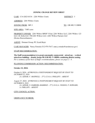
ZONING CHANGE REVIEW SHEET DISTRICT: 3 TO: GR-MU-V-DB90 CASE: C14-2023-0134 – 2201 Willow Creek ADDRESS: 2201 Willow Creek ZONING FROM: MF-3 SITE AREA: 7.085 acres PROPERTY OWNER: 2201 Willow RFOF V Etal; 2201 Willow LLC; 2201 Willow 123 LLC; JL Sofia LLC; TH 2201 Willow LLC; 2201 Willow Partners LLC (Kostas Koutsothanasis) AGENT: Drenner Group, PC (Leah Bojo) CASE MANAGER: Nancy Estrada (512-974-7617, nancy.estrada@austintexas.gov) STAFF RECOMMEDATION: The Staff recommendation is to grant community commercial – mixed use – vertical mixed use building – density bonus 90 (GR-MU-V-DB90) combining district zoning. For a summary of the basis of Staff’s recommendation, please see pages 2 - 4. PLANNING COMMISSION ACTION / RECOMMENDATION: October 22, 2024: October 8, 2024: APPROVED A POSTPONEMENT REQUEST BY STAFF TO OCTOBER 22, 2024 [A. AZHAR; F. MAXWELL – 2nd] (12-0) A. PHILLIPS – ABSENT August 27, 2024: APPROVED A POSTPONEMENT REQUEST BY STAFF TO OCTOBER 8, 2024 [A. AZHAR; N. BARRERA-RAMIREZ – 2nd] (10-0) A. WOODS, P. HOWARD, A. PHILLIPS – ABSENT CITY COUNCIL ACTION: ORDINANCE NUMBER: C14-2023-0134 Page 2 ISSUES: The developer will comply with the Tenant Notification and Relocation Assistance requirements in the City of Austin Land Development Code. [LDC 25-1-712]. The applicant has provided the following information as proposed Tenant Protection items: • The property manager will not terminate leases before the end of the lease term (including month-to-month tenancies), unless for just cause. • Once the new project is completed, tenants will have the right to return with priority access to the new units. • The owner must provide tenants with at least 48 hours’ notice before entering their units, except in cases of emergency. • Tenants will receive a minimum of 180 days' notice before any demolition of the existing property begins. • Upon receiving demolition notice, tenants may break their leases without penalty. • A minimum of 90 days' move-out notice will be given to remaining tenants before the planned demolition date. • Upon moving out, tenants who remain after receiving a move-out notice will receive a full refund of their security and pet deposits. • On-site services will be available to assist tenants in finding new housing or other qualifying programs after the move-out notice is issued. • A $3,000 moving allowance will be provided to tenants who remain after • The last three months of rent will be waived for tenants who remain after receiving a move-out notice. receiving a move-out notice. The items listed are subject to being amended. CASE MANAGER COMMENTS: The subject rezoning area consists of approximately 7.09 acres and is located on Willow Creek Drive just north of East Oltorf Street. It is within the East Riverside/Oltorf Combined Neighborhood Planning Area but does not have a Future Land Use Map (FLUM) designation since it was intentionally withheld during the adoption of the neighborhood plan. The subject property is currently developed with 210 multifamily residences which were built in two phases. The first phase was built in 1973 and is 50 years old and the second phase was built in 1983 and is 40 years old. The rezoning area is surrounded by multifamily residences immediately to the east as well as to the north across Anken Drive and to the west across Willow Creek Drive (MF-2; MF-3; ERC). Commercial services and restaurants are immediately south of the property and across East Oltorf Street (GR). Please refer to Exhibits A (Zoning Map) and A-1 (Aerial View). The Applicant is requesting to rezone the property to community commercial – mixed use – vertical mixed use building – density bonus 90 (GR-MU-V-DB90) combining district zoning. The applicant is proposing approximately 1100 multifamily units and 20,000 square feet of commercial. Access to the property is proposed from both Willow Creek Drive and Anken C14-2023-0134 Page 3 Drive. Willow Creek Drive is a Level 2 roadway that intersects with East Oltorf Street, a major arterial roadway. Furthermore, South Pleasant Valley Road is an Imagine Austin Corridor just east of the property. A building constructed under vertical mixed use building (–V) standards is required to contain a mix of residential and commercial uses, and the result is typically retail, restaurants and offices on the ground floor, and residential units on the upper levels. Staff is recommending (GR-MU-V-DB90) since this is consistent with the City’s goals of increasing housing options that will include affordable units through density bonus incentives. BASIS OF RECOMMENDATION: 1. The proposed zoning should be consistent with the purpose statement of the district sought. The proposed community commercial (GR) district is intended for office and commercial uses serving neighborhood and community needs, including both unified shopping centers and individually developed commercial sites, and typically requiring locations accessible from major trafficways. The mixed use (MU) district is intended to allow for office, retail, commercial and residential uses to be combined in a single development. The vertical mixed use building (V) combining district may be applied in combination with any commercial base zoning district and allows for a combination of office, retail, commercial and residential uses within a vertical mixed use building. The Density Bonus 90 (DB90) combining district, in exchange for providing affordable housing units and in combination with commercial base zoning districts, allows a mixture of office, retail, commercial, and residential uses with modifications of compatibility standards and site development regulations including increased building height. 2. Zoning changes should promote the policy of locating retail and more intensive zoning near the intersections of arterial roadways or at the intersections of arterials and major collectors. Community commercial – mixed use – vertical mixed use building – density bonus 90 – (GR-MU-V-DB90) combining district zoning is appropriate for the subject property due to its location near the intersection of East Oltorf Street and South Pleasant Valley Road, which are both major arterial roadways. South Pleasant Valley Road is also an Imagine Austin Corridor. 3. Staff is recommending (GR-MU-V-DB90) combining district zoning for the subject property based on the following considerations: 1) community commercial – mixed use – vertical mixed use building – density bonus 90 (GR-MU-V-DB90) is appropriate due to its location Zoning changes should promote compatibility with adjacent and nearby uses. C14-2023-0134 Page 4 just north of East Oltorf Street and its proximity to South Pleasant Valley Road, 2) it is consistent with the existing adjacent (GR) commercial zoning to the south and to the west across Willow Creek, 3) this site is located within 0.25 miles of four public transit bus stops and within 0.50 miles of an additional five transit bus stops. It is currently served by four Capital Metro bus routes, 4) major arterials such as East Oltorf Street and South Pleasant Valley Road are easily accessible and provide connectivity to goods and services, and 5) potential commercial uses would be available to serve residents of the proposed future development and the surrounding area, as well as the wider community. EXISTING ZONING AND LAND USES: ZONING Site North MF-3; ERC-CMU; ERC-NMU MF-3 South GR; MF-3-CO; East MF-2 West GR; MF-3 LAND USES Multifamily residences (210 units) Multifamily residences Commercial Services; Food sales; Multifamily residences Multifamily residences Multifamily residences; Fuel Station; Commercial Services; Food sales Travis High School Lively Middle School SCENIC ROADWAY: No NEIGHBORHOOD PLANNING AREA: East Riverside/Oltorf Combined (Riverside) WATERSHED: Country Club West – Suburban CAPITOL VIEW CORRIDOR: No SCHOOLS: Austin Independent School District: Linder Elementary School COMMUNITY REGISTRY LIST: Austin Independent School District Austin Lost and Found Pets Austin Neighborhoods Council Crossing Gardenhome Owners Assn. (The) Friends of Riverside ATX Neighborhood Assn. Neighborhood Empowerment Foundation Southeast Austin Neighborhood Alliance Sierra Club Austin Regional Group Burleson Road Heights Neighborhood Association East Riverside/Oltorf Neighborhood Plan Contact Team Friends of Austin Neighborhoods Homeless Neighborhood Association Overton Family Committee Pleasant Valley Preservation Austin SELTexas Save Our Springs Alliance Del Valle Community Coalition C14-2023-0134 Page 5 AREA CASE HISTORIES: NUMBER REQUEST COMMISSION CITY COUNCIL C14-2023-0047 – 1911 Willow Creek C14-2016-0087 – 2431 East Oltorf Street C14-05-0112 ERC-UR to ERC-CMU; to modify max. height allowed through participation in density bonus program To Grant ERC-CMU and to modify max. height allowed through participation in density bonus program. (03/26/2024) GR to MF-6-CO To Grant MF-6-CO. (12/13/2016) To Grant East Riverside Neighborhood Plan – Addition of -NP Combining District and change Base District Zoning Apvd ERC-CMU and to modify max. height allowed through participation in density bonus program. (05/02/2024) Apvd MF-6-CO as Commission recommended (02/06/2017) Apvd to Add -NP Combining District (11/16/2006) RELATED CASES C8-72-150 – subject rezoning area is described as Willow Creek Section Five Subdivision, recorded on January 15, 1973 ADDITIONAL STAFF COMMENTS: Comprehensive Planning Project Name and Proposed Use: 2201 WILLOW CREEK DR. C14-2023-0134. 7.085 acres from MF-3 to GR-MU-V-DB90. Existing: Demolish 210 multifamily apartments. Proposed: Vertical Mixed Use Project with approximately 1,100 multifamily units and 20,000 sq. ft. of commercial. Yes Imagine Austin Decision Guidelines Complete Community Measures * Y Imagine Austin Growth Concept Map: Located within or adjacent to an Imagine Austin Activity Center, Imagine Austin Activity Corridor, or Imagine Austin Job Center as identified the Growth Concept Map. Names of Activity Centers/Activity Corridors/Job Centers *: 0.10 miles from S Pleasant Valley Activity Corridor and 0.14 miles from the Riverside Station Town Center Y Mobility and Public Transit *: Located within 0.25 miles of public transit stop and/or light rail station. Y Mobility and Bike/Ped Access *: Adjoins a public sidewalk, shared path, and/or bike lane. Y Connectivity, Good and Services, Employment *: Provides or is located within 0.50 miles to goods and services, and/or employment center. C14-2023-0134 Page 6 Y Connectivity and Food Access *: Provides or is located within 0.50 miles of a grocery store/farmers market. Connectivity and Education *: Located within 0.50 miles from a public school or university. Y Connectivity and Healthy Living *: Provides or is located within 0.50 miles from a recreation area, park or walking trail. Connectivity and Health *: Provides or is located within 0.50 miles of health facility (ex: hospital, urgent care, doctor’s office, drugstore clinic, and/or specialized outpatient care.) Y Housing Choice *: Expands the number of units and housing choice that suits a variety of household sizes, incomes, and lifestyle needs of a diverse population (ex: apartments, triplex, granny flat, live/work units, cottage homes, and townhomes) in support of Imagine Austin and the Strategic Housing Blueprint. Y Housing Affordability *: Provides a minimum of 10% of units for workforce housing (80% MFI or less) and/or fee in lieu for affordable housing. Y Mixed use *: Provides a mix of residential and non-industrial uses. Culture and Creative Economy *: Provides or is located within 0.50 miles of a cultural resource (ex: library, theater, museum, cultural center). Culture and Historic Preservation: Preserves or enhances a historically and/or culturally significant site. Creative Economy: Expands Austin’s creative economy (ex: live music venue, art studio, film, digital, theater.) Workforce Development, the Economy and Education: Expands the economic base by creating permanent jobs, especially in industries that are currently not represented in a particular area or that promotes a new technology, and/or promotes educational opportunities and workforce development training. Industrial Land: Preserves or enhances industrial land. Y Not located over Edwards Aquifer Contributing Zone or Edwards Aquifer Recharge Zone 10 Number of “Yes’s” Drainage The developer is required to submit a pre- and post-development drainage analysis at the subdivision and site plan stage of the development process. The City’s Land Development Code and Drainage Criteria Manual require that the Applicant demonstrate through engineering analysis that the proposed development will have no identifiable adverse impact on surrounding properties. Environmental The site is not located over the Edwards Aquifer Recharge Zone. The site is in the Country Club West Watershed of the Colorado River Basin, which is classified as a Suburban Watershed by Chapter 25-8 of the City's Land Development Code. The site is in the Desired Development Zone. Under current watershed regulations, development or redevelopment on this site will be subject to the following impervious cover limits: C14-2023-0134 Page 7 Development Classification % of Gross Site Area % of Gross Site Area Single-Family (minimum lot size 5750 sq. ft.) Other Single-Family or Duplex Multifamily Commercial 50% 55% 60% 80% with Transfers 60% 60% 70% 90% According to floodplain maps there is no floodplain within or adjacent to the project location. Standard landscaping and tree protection will be required in accordance with LDC 25-2 and 25-8 for all development and/or redevelopment. At this time, site specific information is unavailable regarding vegetation, areas of steep slope, or other environmental features such as bluffs, springs, canyon rimrock, caves, sinkholes, and wetlands. Under current watershed regulations, development or redevelopment requires water quality control with increased capture volume and control of the 2 year storm on site. At this time, no information has been provided as to whether this property has any preexisting approvals that preempt current water quality or Code requirements. Site Plan Site plans will be required for any new development other than residential only project with up to 4 units. Any new development is subject to Subchapter E. Design Standards and Mixed Use. Additional comments will be made when the site plan is submitted. The Property is located within the East Riverside/Oltorf Combined Neighborhood Planning Area (NPA) and does not have a Future Land Use Map designation. PARD – Planning & Design Review Parkland dedication will be required at the time of subdivision or site plan application for new residential units proposed by this rezoning, multifamily with GR-MU-V-DB90, per City Code § 25-1-601, as amended. The intensity of the proposed development creates a need for over six acres of additional parkland, per the current requirements described in § 25-1-602; when over six acres, parkland must be dedicated – see § 25-1-605 (A)(2)(a). However, the parkland dedication code will be amended to comply with state law – any development application submitted after January 1, 2024 will be reviewed under the new requirements and may owe a different amount. C14-2023-0134 Page 8 The surrounding neighborhood areas are currently park deficient, defined as being outside walking distance to existing parks. A dedication of parkland onsite with a new development may satisfy the need for additional parks in park deficient areas of Southeast Austin, a specific recommendation in the Parks and Recreation Department’s Long Range Plan. Should there be any remaining fees in-lieu, those fees shall be used toward park investments in the form of land acquisition and/or park amenities within the surrounding area, per the Parkland Dedication Operating Procedures § 14.3.11 and City Code § 25-1-607 (B)(1) & (2). If the applicant wishes to discuss parkland dedication requirements in advance of site plan or subdivision applications, please contact this reviewer: thomas.rowlinson@austintexas.gov. At the applicant’s request, PARD can provide an early determination letter of the requirements. Austin Transportation Department – Engineering Review Zoning transportation analysis (ZTA) shall be performed at zoning where anticipated trips are anticipated to exceed 2,000 unadjusted trips to satisfy the LDC requirement for a TIA but does not diminish the authority to require a traffic impact analysis at site plan. LDC 25-6, TCM 10.5.0. A ZTA is required for this zoning case. The Austin Strategic Mobility Plan (ASMP) calls for 84 feet of right-of-way for Willow Creek Drive. It is recommended that 42 feet of right-of-way from the existing centerline should be dedicated for Willow Creek Drive according to the Transportation Plan with the first subdivision or site plan application. [LDC 25-6-51 and 25-6-55]. The Austin Strategic Mobility Plan (ASMP) calls for 58 feet of right-of-way for Anken Drive. It is recommended that 29 feet of right-of-way from the existing centerline should be dedicated for Anken Drive according to the Transportation Plan with the first subdivision or site plan application. [LDC 25-6-51 and 25-6-55]. The adjacent street characteristics table is provided below: Name ASMP Existing ROW Existing Pavement Sidewalks Bicycle Route Classification ASMP Required ROW Anken Drive Level 1 – Residential Collector 58’ 51’ 42’ Yes No Capital Metro (within ¼ mile) Yes C14-2023-0134 Page 9 Willow Creek Drive Level 2 – Collector 84’ 72’ 44’ Yes Yes Yes A Traffic Impact Analysis (TIA) has been waived at this time since a Zoning Transportation Analysis (ZTA) is required. Please refer to Attachment A. Austin Water Utility No comments on zoning change. The landowner intends to serve the site with existing City of Austin water utilities. Depending on the development plans submitted, water and or wastewater service extension requests may be required. All water and wastewater construction must be inspected by the City of Austin. For more information pertaining to the Service Extension Request process and submittal requirements contact the Austin Water SER team at ser@austintexas.gov. INDEX OF EXHIBITS AND ATTACHMENTS TO FOLLOW: Exhibit A: Zoning Map Exhibit A-1: Aerial Map Applicant’s Summary Letter - AMENDED Applicant’s Summary Letter Attachment A: Zoning Transportation Analysis (ZTA) ( ( ( SF-3-NP V A L L E Y H I L L C I R ! ! ! ! ! ! MF-2 C14-2015-0091 APTS. 69-308 ! ! ! ! ! ! MF-4-CO ! ! C14-00-2194 ! 00-2194 84-161 ! ! ! ! ! ! ! SF-3 MF-2 ! ! ! ! ! ! ! MF-2 MF-3 O T R U B R N D APTS. CP72-36 69-127 ! ! ! ! APTS. ! ! MARIPOSA DR ! ! ! ! 69-288 APTS. CS-1 72-37 P71-30 MF-3 APTS. APTS. C14-05-0112 SP-02-0127C C14-2008-0149 APTS. CP72-36 APTS. 06-0023 C14-95-0168 95-0168 ! ! ! ! ! ! ! ! ! ! APARTMENTS ! ! R K D E E R ! ! W C O L ! ! WIL ! ! ! ! ! ! ! ! NPA-2012-0021.02 NPA-2011-0021.02 C14-2012-0111 ! ! ! ! ERC ! ! ! ! ! ! ! ! ! ! !! APARTMENTS ! ! ! ! ! 72-239 SP-93-0509C ! ! ! ! ! ! SP-99-0287C 94-34 SP93-0390C WILLO W HILL D R RZ85-093 SP-04-0222C E R I V E R S I D E D R r85-320 C14-96-0097 UNDE V RZ85-065 99-2115 93-0142 C14-99-2115 ERC SP-99-0037C APTS. APA RTME NTS MF-3 CONV. STORE SP96-0446CS ST O R E IN LO N W A P P O H S T 1 O F CS-1 GR R ETAIL C E NTE R 85-153 APTS. 1500'S Q.FT. LIQ U O R R E TAIL C E N T E R ! ! ! ! ! ! ! ! ! ! APTS. CP72-66 ! ! CONV. STORE GAS STA. ! ! ! ! ! APTS. MF-3 ! P82-070 ! SHOPPING CENTER ! ! ! ! ! APARTMENTS A N ! K ! E N D ! R ! ! ! ! T S A F D O O F O T U A I E C V R E S CAR WASH 2-PLE X GR RETAIL CE CP14-72-066 ! ! ! 02-0003 ! ! C14-02-0003 CS-1-CO GR ! ! 83-131 ! 83-131 C14-83-131 CENTER C14P-78-34 ! ! ! ! ! SHOPPING APTS. MF-2 C14-72-239 72-239 83-130 MF-6-CO C14-2016-0087 98-0083 C14-96-0120 CS-CO 96-0120 P83-82 CP14-73-007 S H E RIN G H A M D R D Y R E L L A T V N A S A E L S P APARTMENTS C14-72-239 93-140 MF-3-CO C14-93-0140 P83-61 74-112 SP-99-0018C P71-30 MF-3 APTS. MF-3-CO-NP NPA-2021-0021.01.SH C14-2021-0008.SH SF-3-NP APARTMENTS GR REST. SF-3-NP X E L 2-P P85-015 70-204 APTS. MF-2-NP SF-3-NP SF-3-NP ( ( T S S A L G U O D ( ( ( SF-3-NP ( ( ( ( ( ( ± NTER 87-116 87-013 SP85-165 CS-1 MF-2-NP 70-204 APTS. T S S A L G U O D SP87-09 85-202 SP-98-0360C MF-1-NP 70-204 SF-3-NP R N D O T E C RIN P ( ( ( RR-NP ( ( ( SF-3-NP 05-0111 ( ( ( ( ( ( ( ( ( ( D E R R A W ( B E NJA ( SF-3-NP ( MIN S ( T ( ( ( MF-3-CO C14-93-0139 93-0139 MF-2-NP C14-05-0113 APTS. RR 93-0140 93-0116 MF-3-CO 72-239 SF-3-NP 93-0116 P83-83 APTS. RR LR C14-72-239 S P-02-0261C 05-0111 72-239 P85-017 MF-2 MF-2 GR-MU-CO C14-2012-0114 E O L T O R F S T 83-47 SF-3-NP C OLLIN SF-3-NP S C R E E K D R MF-2-NP H U N T W IC K D R CONDOS MF-2 P84-044 P84-038 MF-2-NP SUBJECT TRACT ! ! ! ! ! ! PENDING CASE ZONING BOUNDARY ZONING CASE#: C14-2023-0134 ZONING EXHIBIT A This product is for informational purposes and may not have been prepared for or be suitable for legal, engineering, or surveying purposes. It does not represent an on-the-ground survey and represents only the approximate relative location of property boundaries. 1 " = 400 ' This product has been produced by the Planning Department for the sole purpose of geographic reference. No warranty is made by the City of Austin regarding specific accuracy or completeness. Created: 11/6/2023 EXHIBIT A-1 !!!!!!!!!!!!!!!!!!!!!!!!!!!!!!!!!!!!!!!!!!!!!!!!!!!!!!!!!!!!!!!!!!!!!!!!!!!!!!!!!!!!!!!!!!!!!!!!!!!!!!!!!!!!!!!!!!!!!!!!!!!!!!!!!!!(!(!(!(!(!(!(!(!(!(!(!(!(!(!(!(!(!(!(!(!(!(!(!(!(!(!(!(!(!(!(!(!(!(!(!(!(J19K19K18J18C14-2023-0134C14-05-0112C14-2012-0111C14-05-0113NPA-2011-0021.02NPA-2012-0021.02C14-93-0140C14-95-0168C14-2015-0091C14-2016-0087C14-93-0139C14-99-2115C14-2021-0008.SHNPA-2021-0021.01.SHC14-2012-0114C14-2008-0149C14-96-0120C14-96-0097C14-02-0003EOLTORFSTBURTONDRANKENDRWILLOWCREEKDRSPLEASANTVALLEYRDBENJAMINSTWARERDDOUGLASSTPRINCETONDRHUNTWICKDRWILLOWHILLDRCOLLINSCREEKDRSHERINGHAMDRERIVERSIDEDRMARIPOSADRVALLEYHILLCIRDOUGLASSTERCMF-3MF-2-NPMF-3GRMF-3GRMF-3GRMF-2GRMF-1-NPMF-2-NPMF-2MF-2-NPMF-3-COERCMF-2MF-4-COSF-3-NPMF-6-COSF-3-NPSF-3-NPSF-3-NPMF-3-CORR-NPSF-3-NPMF-2-NPLRSF-3-NPMF-3-COSF-3-NPRRSF-3-NPMF-3-CO-NPMF-3SF-3-NPSF-3-NPSF-3-NPMF-2GR-MU-COCS-1RRMF-2SF-3CS-COMF-2-NPCS-1MF-2MF-2CS-1CS-1-COSF-3-NP2201 Willow Creek Drive±This product has been produced by the Planning Department for the sole purpose of geographic reference. No warrantyis made by the City of Austin regarding specific accuracy or completeness.ZONING CASE#:LOCATION:SUBJECT AREA:GRID:MANAGER:C14-2023-01342201 Willow Creek Dr7.085 AcresJ19Nancy EstradaCreated: 12/12/2023SUBJECT TRACTZONING BOUNDARY!!!!!!PENDING CASECREEK BUFFER0200400600800100Feet Leah M. Bojo lbojo@drennergroup.com 512-807-2918 Ms. Lauren Middleton-Pratt Planning Department City of Austin 1000 E 11th Street Austin, TX 78702 Dear Ms. Middleton-Pratt: March 11, 2024 Via Electronic Delivery Re: C14-2023-0134 2201 Willow Creek Drive Update – Rezoning application for 7.085-acre property located at 2201 Willow Creek Drive, Austin, TX 78741, TCAD ID: 0308060203 (the "Property") As representatives of the owners of the Property, we respectfully submit this letter to amend the rezoning application request currently in review and assigned case number C14-2023-0134, submitted to the City of Austin (the “City”) on October 5, 2023. The original rezoning request was from MF-3 (Multifamily Residence Medium Density) to GR-V-MU (Community Commercial – Vertical Mixed-Use Building – Mixed Use Combining District). With this amendment, the owner requests to add the DB90 (Density Bonus 90) combining district, which was recently approved on February 29, 2024, via Ordinance No. 20240229-073, (the “DB90 Ordinance”), attached herein, to the submitted rezoning request. The Property is located within the East Riverside/Oltorf Combined Neighborhood Planning Area (NPA) and was intentionally withdrawn from the adoption of the neighborhood plan adopted in Ordinance No. 20061116-057 and therefore does not have a Future Land Use Map designation. We have previously been in communication with the Neighborhood Contact Team regarding this application. We intend to resume conversations and meetings with the neighborhood as we move forward with this request. Please let me know if you or your team members require additional information or have any questions. Thank you for your time and attention to this project. Sincerely, Leah M. Bojo cc: Joi Harden, Planning Department (via electronic delivery) Leah M. Bojo lbojo@drennergroup.com 512-807-2918 Ms. Lauren Middleton-Pratt Planning Department City of Austin 1000 E 11th Street Austin, TX 78702 Dear Ms. Middleton-Pratt: October 3, 2023 Via Electronic Delivery Re: 2201 Willow Creek Drive – Zoning application for 7.085-acre property located at 2201 Willow Creek Drive, Austin, TX 78741, TCAD ID: 0308060203 (the "Property") As representatives of the owners of the Property, we respectfully submit the enclosed Zoning application package. The project is titled 2201 Willow Creek Drive and is 7.085 acres of land, located on the east side of Willow Creek Drive north of E. Oltorf Street. The Property is in the Full Purpose Jurisdiction of the City of Austin. The Property is currently zoned MF-3 (Multifamily Residence Medium Density). The requested zoning is GR-V-MU (Community Commercial – Vertical Mixed Use Building – Mixed Use Combining District). The proposed use is mixed use. The Property is currently developed with a multifamily use that was built in two phases; the first phase was built in 1973 and is 50 years old and the second phase was built in 1983 and it 40 years old. The Property is located within the East Riverside/Oltorf Combined Neighborhood Planning Area (NPA) and was intentionally withdrawn from the adoption of the neighborhood plan adopted in Ordinance No. 20061116-057 and therefore does not have a Future Land Use Map designation. Although not part of the East Riverside/Oltorf Combined Neighborhood Plan, this proposal contributes to the stated goals of improving the “Encourage pedestrian and bike friendly neighborhoods” (Goal 2) and “Create lively, inviting, attractive and safe commercial and office street environments.” (Goal 8). A Zoning Transportation Analysis (ZTA) is required per the attached TIA determination waiver dated August 11, 2023, by Adrianna Morrow. Please let me know if you or your team members require additional information or have any questions. Thank you for your time and attention to this project. Sincerely, Leah M. Bojo cc: Joi Harden, Planning Department (via electronic delivery) ATTACHMENT A MEMORANDUM Date: To: CC: Reference: October 3rd, 2024 Ravali Kosaraju, P.E., WGI, Inc. Adrianna Morrow, Danielle Morin Transportation Public Works 2201 Willow Creek – C14-2023-0134 Zoning Transportation Analysis (ZTA) Final Memo The Austin Transportation & Public Works Department (TPW) has reviewed the “2201 Willow Creek Rockfarmer Rezoning ZTA” prepared by WGI, Inc., for zoning case C14-2023-0134. This zoning case proposes 1,100 for-rent units and 20,000 square feet (SF) of retail. The development is located one block north of E Oltorf Street, at the southeast corner of Willow Creek Drive and Anken Drive (shown in Figure 1 below), at 2201 Willow Creek Drive, Austin, Texas. The proposed development is expected to be completed in one phase by 2025. Figure 1: Site Location Adjacent Roadway Characteristics: The project proposes access to the surrounding roadway network through one full-access driveway on Anken Drive and one full-access driveway on Willow Creek Drive. Anken Drive: Designated as a Level 1 road with 58-64 feet of right-of-way required per the Austin Strategic Mobility Plan (ASMP) with a posted speed limit of 30 mph. It is a two-lane, two-way road with curb and gutter, on-street parking on both sides and no lane striping. On-street parking spaces are located within the sight distance triangle. A sidewalk exists on the south side, but none on the north. There are no short-term ASMP improvements identified. The average daily traffic (ADT) is approximately 3,089 vehicles, based on 24-hour counts collected at the Willow Creek Drive and Anken Drive intersection on Tuesday May 7th, 2024. Willow Creek Drive: Designated as a Level 2 road with 84 feet of right-of-way required per the ASMP, and a posted speed limit of 30 mph. Willow Creek Drive is a two-lane, two-way road with curb and gutter and on-street parking on alternating sides. Closest to the site, parking is located on the opposite side. Buffered bike lanes exist on both sides. South of Anken Drive, there are sidewalks on both sides. North of Anken Drive, the sidewalk is continuous only on the western side of Willow Creek Drive, with most of the sidewalk missing along the eastern side of Willow Creek Drive. The ASMP proposes improvements to bicycle facilities. The ADT is approximately 6,017 vehicles based on 24-hour counts collected at the Willow Creek Drive and Anken Drive intersection on Tuesday May 7th, 2024. Trip Generation and Traffic Analysis: Based on the Institute of Transportation Engineers (ITE) Trip Generation Manual (11th Edition), the site development is expected to generate approximately 5,115 net new daily trips, 424 AM peak hour trips (adjusted), and 388 PM peak hour trips (adjusted). The AM and PM peak hour trips were adjusted based on calculated rates for multifamily and retail uses. For the PM peak hour, a 40% reduction was applied to the strip retail plaza. While the proposed retail does not meet the minimum 40,000 square feet to qualify as a Shopping Plaza (ITE Code 821), TDS engineers support a 40% pass-by trip reduction for the proposed 20,000 square feet of retail, based on the ITE Trip Generation Handbook, 3rd Edition and the 2021 Pass-By Tables for ITE TripGen. Table 1: Trip Generation Average Daily Traffic was estimated for the 2024 existing conditions, based on 24-hour volume counts collected on Tuesday May 7th, 2024, at the Willow Creek Drive and Anken Drive intersection. A 2% per year growth factor from 2024-2025 was used to project ADT volumes for 2025. Table 2: Projected Volume Analysis Road Segment ASMP Class 2024 ADT 2025 ADT 2025 ADT Site Anken Drive Level 1 3,089 3,150 2,000 2025 ADT (Site + Forecasted) 5,150 Level 2 6,017 6,137 2,211 8,348 Existing Cross Section 2 Lanes, undivided 2 lanes, undivided Willow Creek Drive The analysis show that traffic from the site, combined with forecasted volumes for 2025, will exceed the typical ADT range recommended for level 1 urban roadways in the City of Austin Street Design Guide which advises less than 2,000 ADT for level 1 roadways. Several Transportation Demand Management (TDM) measures, per the Transportation Criteria Manual (TCM), will be proposed at the site plan stage to achieve a minimum 30% trip reduction. These measures will help minimize the impact on the surrounding network. Additionally, an ASMP right-of-way assessment for abutting road segments, a turn lane analysis for all driveways, and a sight distance analysis for the new driveways were conducted. Recommendations/Conclusions: As a condition for approval for this zoning case, the applicant must adhere to the following recommendations: ASMP ROW Needs: Right-of-way dedications may be required to meet ASMP standards, which will be TDM: The development must achieve a minimum 30% trip reduction using TDM measures per the TCM, with confirmed at the Site Plan stage. details determined at the site plan stage. Street Impact Fee (SIF): The development is subject to the City of Austin Street Impact Fee (Ordinance # 20201220-061 & 20201210-062). The SIF will be calculated at the site plan submission and collected at the time of the building permit. No SIF offsets will be granted until the completion of any identified construction items unless those items are included in the site plan. Driveway Approvals: The site proposes two new driveways-one on Anken Drive and one on Willow Creek Drive. Approval of the ZTA does not guarantee approval of these driveway locations. The driveways will undergo further review during the site plan process by the appropriate City departments. Transportation Analysis: This ZTA does not waive the requirement for a Transportation Assessment (TA) or a full Transportation Impact Analysis (TIA) at the time of site plan. Please contact me at (512) 974-7136 with any questions or for further information. Sincerely, Nathan Aubert, P.E. Tranportation & Public Works Department