12 NPA-2024-0015.02 - Seventh Day Adventist Alpha Church; District 1 Staff Report — original pdf
Backup
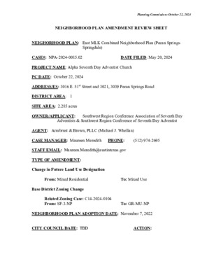
Planning Commission: October 22, 2024 NEIGHBORHOOD PLAN AMENDMENT REVIEW SHEET NEIGHORHOOD PLAN: East MLK Combined Neighborhood Plan (Pecan Springs- Springdale) DATE FILED: May 20, 2024 CASE#: NPA-2024-0015.02 PROJECT NAME: Alpha Seventh Day Adventist Church PC DATE: October 22, 2024 ADDRESS/ES: 3016 E. 51st Street and 3021, 3039 Pecan Springs Road DISTRICT AREA: 1 SITE AREA: 2.285 acres OWNER/APPLICANT: Southwest Region Conference Association of Seventh Day Adventists & Southwest Region Conference of Seventh Day Adventist (512) 974-2695 AGENT: Armbrust & Brown, PLLC (Michael J. Whellan) CASE MANAGER: Maureen Meredith STAFF EMAIL: Maureen.Meredith@austintexas.gov TYPE OF AMENDMENT: Change in Future Land Use Designation PHONE: From: Mixed Residential Base District Zoning Change To: Mixed Use Related Zoning Case: C14-2024-0104 From: SF-3-NP To: GR-MU-NP NEIGHBORHOOD PLAN ADOPTION DATE: November 7, 2022 CITY COUNCIL DATE: TBD ACTION: Planning Commission: October 22, 2024 PLANNING COMMISSION RECOMMENDATION: October 22, 2024 – (action pending) STAFF RECOMMENDATION: Staff recommends an alternate land use of Neighborhood Mixed Use. BASIS FOR STAFF’S RECOMMENDATION: Staff recommends an alternative land use of Neighborhood Mixed Use which is consistent with zoning staff recommendation of LR- MU-NP (Neighborhood Commercial – Mixed Use Combining District – Neighborhood Plan). Although the property has frontage on E. 51st Street, which is an activity corridor, the property’s location near lower density residential uses makes the Neighborhood Mixed use a more compatible land use. Below are sections of the E. MLK Combined Neighborhood Plan that supports staff’s recommendation. The plan supports mixed use at E. 51st Street/Springdale Road and E. 51st Street and Manor Road. 2 Planning Commission: October 22, 2024 LAND USE DESCRIPTIONS: EXISTING LAND USE: Mixed Residential - An area with a variety of different housing types, including single- family residential, townhouses, duplexes, apartments, and limited neighborhood- serving retail. Single-family residential should comprise at least half of a mixed residential area. Purpose 1. Create multiple housing types of varying densities to provide a high degree of housing choice; and 3 2. 2. Encourage flexibility and better design for residential development on larger Planning Commission: October 22, 2024 residential parcels. Application 1. Appropriate for larger tracts having access to major roadways that are not suitable for commercial or mixed use;2. Encourage flexibility and better design for residential development on larger residential parcels. 2. Primarily implemented through the Residential Infill special use, but can be achieved with the mixing of different residential districts if the intent is met; and 3. Generally applicable to sites of 1 acre or greater. PROPOSED LAND USE: Mixed Use - An area that is appropriate for a mix of residential and non‐residential uses. Purpose 1. Encourage more retail and commercial services within walking distance of residents; 2. Allow live‐work/flex space on existing commercially zoned land in the neighborhood; 3. Allow a mixture of complementary land use types, which may include housing, retail, offices, commercial services, and civic uses (with the exception of government offices) to encourage linking of trips; 4. Create viable development opportunities for underused center city sites; 5. Encourage the transition from non‐residential to residential uses; 6. Provide flexibility in land use standards to anticipate changes in the marketplace; 7. Create additional opportunities for the development of residential uses and affordable housing; and 8. Provide on‐street activity in commercial areas after 5 p.m. and built‐in customers for local businesses. Application 1. Allow mixed use development along major corridors and intersections; 2. Establish compatible mixed‐use corridors along the neighborhood’s edge 4 Planning Commission: October 22, 2024 3. The neighborhood plan may further specify either the desired intensity of commercial uses (i.e. LR, GR, CS) or specific types of mixed use (i.e. Neighborhood Mixed Use Building, Neighborhood Urban Center, Mixed Use Combining District); 4. Mixed Use is generally not compatible with industrial development, however it may be combined with these uses to encourage an area to transition to a more complementary mix of development types; 5. The Mixed Use (MU) Combining District should be applied to existing residential uses to avoid creating or maintaining a non‐conforming use; and 6. Apply to areas where vertical mixed use development is encouraged such as Core Transit Corridors (CTC) and Future Core Transit Corridors. STAFF’S ALTERNATE LAND USE RECOMMENDATION: Neighborhood Mixed Use - An area that is appropriate for a mix of neighborhood commercial (small shopfront retail that serve a market at a neighborhood scale) and small to medium residential uses. Purpose scale retail or offices, professional services, convenience retail, and density ‐ ‐ 1. Accommodate mixed use development in areas appropriate for a mix of residential uses and neighborhood commercial uses that serve surrounding neighborhoods; and 2. Provide transition from residential use to high intensity commercial or mixed use. Application 1. Appropriate for areas such as minor arterials and collectors, small parcels along major family residential development, and areas in environmentally arterials that abut single sensitive zones where high intensity commercial uses are discouraged; and ‐ 2. May be used as a transition from high intensity commercial and residential uses to family residential uses. ‐ single 5 Planning Commission: October 22, 2024 Yes Yes Imagine Austin Decision Guidelines Complete Community Measures Imagine Austin Growth Concept Map: Located within or adjacent to an Imagine Austin Activity Center, Imagine Austin Activity Corridor, or Imagine Austin Job Center as identified the Growth Concept Map. Name(s) of Activity Center/Activity Corridor/Job Center: • Has frontage on E. 51st Street, which is an Activity Corridor • Approx. 0.25 miles east of Manor Road, which is an Activity Corridor • Approx. 0.33 miles west of Springdale Road, which is an Activity Corridor Yes Mobility and Public Transit: Located within 0.25 miles of public transit stop and/or light rail station. • Bus routes along E. 51st Street and Manor Rd Yes Mobility and Bike/Ped Access: Adjoins a public sidewalk, shared path, and/or bike lane. Yes Connectivity, Good and Services, Employment: Provides or is located within 0.50 miles to goods and services, and/or employment center. Yes Connectivity and Food Access: Provides or is located within 0.50 miles of a grocery store/farmers market. No Connectivity and Education: Located within 0.50 miles from a public school or university. Yes Connectivity and Healthy Living: Provides or is located within 0.50 miles from a recreation area, park or • • • • • • • • • • 0.3 miles from EZ Stop Groceries and Gas 0.4 miles from Dollar General (with limited groceries) 0.5 miles from Sam’s Mini Mart 1.2 miles from HEB Grocery 1.1 miles from Pecan Springs Elementary School 1.1 miles from Blanton Elementary School 1.2 miles from Marshall Middle School walking trail. 0.5 miles from Tannehill Branch Greenbelt, Austin 0.6 miles from Little Walnut Creek Greenbelt Trailhead 1.1 miles from Bartholomew District Park doctor’s office, drugstore clinic, and/or specialized outpatient care.) 1.8 miles from Dell’s Children Medical Center • No Connectivity and Health: Provides or is located within 0.50 miles of health facility (ex: hospital, urgent care, No Housing Affordability: Provides a minimum of 10% of units for workforce housing (80% MFI or less) and/or fee in lieu for affordable housing. Yes Housing Choice: Expands the number of units and housing choice that suits a variety of household sizes, incomes, and lifestyle needs of a diverse population (ex: apartments, triplex, granny flat, live/work units, cottage homes, and townhomes) in support of Imagine Austin and the Strategic Housing Blueprint. • The proposed zoning of GR-MU-NP would allow for housing. Yes Mixed use: Provides a mix of residential and non-industrial uses. • The proposed zoning of GR-MU-NP would allow for a mixed-use development. No Culture and Creative Economy: Provides or is located within 0.50 miles of a cultural resource (ex: library, theater, museum, cultural center). No Culture and Historic Preservation: Preserves or enhances a historically and/or culturally significant site. No Creative Economy: Expands Austin’s creative economy (ex: live music venue, art studio, film, digital, theater.) No Workforce Development, the Economy and Education: Expands the economic base by creating permanent jobs, especially in industries that are currently not represented in particular area or that promotes a new technology, and/or promotes educational opportunities and workforce development training. Industrial Land: Preserves or enhances industrial land. Number of “Yeses” No 8 6 Proximity to Imagine Austin Activity Centers and Corridors Planning Commission: October 22, 2024 7 Proximity to Public Parks Planning Commission: October 22, 2024 8 Planning Commission: October 22, 2024 Proximity to Public Transportation and Urban Trails IMAGINE AUSTIN GROWTH CONCEPT MAP Definitions Neighborhood Centers - The smallest and least intense of the three mixed-use centers are neighborhood centers. As with the regional and town centers, neighborhood centers are walkable, bikable, and supported by transit. The greatest density of people and activities in neighborhood centers will likely be concentrated on several blocks or around one or two intersections. However, depending on localized conditions, different neighborhood centers can be very different places. If a neighborhood center is designated on an existing commercial area, such as a shopping center or mall, it could represent redevelopment or the addition of housing. A new neighborhood center may be focused on a dense, mixed-use core surrounded by a mix of housing. In other instances, new or redevelopment may occur incrementally and concentrate people and activities along several blocks or around one or two intersections. Neighborhood centers will be more locally focused than either a regional or a town center. Businesses and services—grocery and department stores, doctors and dentists, shops, branch libraries, dry cleaners, hair salons, schools, restaurants, and other small and local businesses—will generally serve the center and surrounding neighborhoods. 9 Planning Commission: October 22, 2024 Town Centers - Although less intense than regional centers, town centers are also where many people will live and work. Town centers will have large and small employers, although fewer than in regional centers. These employers will have regional customer and employee bases, and provide goods and services for the center as well as the surrounding areas. The buildings found in a town center will range in size from one-to three-story houses, duplexes, townhouses, and rowhouses, to low-to midrise apartments, mixed use buildings, and office buildings. These centers will also be important hubs in the transit system. Regional Centers - Regional centers are the most urban places in the region. These centers are and will become the retail, cultural, recreational, and entertainment destinations for Central Texas. These are the places where the greatest density of people and jobs and the tallest buildings in the region will be located. Housing in regional centers will mostly consist of low to high-rise apartments, mixed use buildings, row houses, and townhouses. However, other housing types, such as single-family units, may be included depending on the location and character of the center. The densities, buildings heights, and overall character of a center will depend on its location. Activity Centers for Redevelopment in Sensitive Environmental Areas - Five centers are located over the recharge or contributing zones of the Barton Springs Zone of the Edwards Aquifer or within water-supply watersheds. These centers are located on already developed areas and, in some instances, provide opportunities to address long-standing water quality issues and provide walkable areas in and near existing neighborhoods. State-of-the-art development practices will be required of any redevelopment to improve stormwater retention and the water quality flowing into the aquifer or other drinking water sources. These centers should also be carefully evaluated to fit within their infrastructural and environmental context. Job Centers - Job centers accommodate those businesses not well-suited for residential or environmentally- sensitive areas. These centers take advantage of existing transportation infrastructure such as arterial roadways, freeways, or the Austin-Bergstrom International airport. Job centers will mostly contain office parks, manufacturing, warehouses, logistics, and other businesses with similar demands and operating characteristics. They should nevertheless become more pedestrian and bicycle friendly, in part by better accommodating services for the people who work in those centers. While many of these centers are currently best served by car, the growth Concept map offers transportation choices such as light rail and bus rapid transit to increase commuter options. Corridors - Activity corridors have a dual nature. They are the connections that link activity centers and other key destinations to one another and allow people to travel throughout the city and region by bicycle, transit, or automobile. Corridors are also characterized by a variety of activities and types of buildings located along the roadway — shopping, restaurants and cafés, parks, schools, single-family houses, apartments, public buildings, houses of worship, mixed-use buildings, and offices. Along many corridors, there will be both large and small redevelopment sites. These redevelopment opportunities may be continuous along stretches of the corridor. There may also be a series of small neighborhood centers, connected by the roadway. Other corridors may have fewer redevelopment 10 Planning Commission: October 22, 2024 opportunities, but already have a mixture of uses, and could provide critical transportation connections. As a corridor evolves, sites that do not redevelop may transition from one use to another, such as a service station becoming a restaurant or a large retail space being divided into several storefronts. To improve mobility along an activity corridor, new and redevelopment should reduce per capita car use and increase walking, bicycling, and transit use. Intensity of land use should correspond to the availability of quality transit, public space, and walkable destinations. Site design should use building arrangement and open space to reduce walking distance to transit and destinations, achieve safety and comfort, and draw people outdoors. BACKGROUND: The plan amendment application was filed on May 20, 2024. The applicant proposes to change the land use on the future land use map (FLUM) from Mixed Residential to Mixed Use. The applicant proposes to change the zoning on the property from SF-3-NP (Family Residence district – Neighborhood Plan) to GR-MU-NP (Community Commercial district – Mixed Use combining district – Neighborhood Plan). For more information on the proposed zoning, see case report C14-2024-0104. The applicant stated at the virtual community meeting that the purpose of the proposed rezoning to GR-MU-NP is to pave an existing unpaved parking lot located at the rear of the church building. See virtual meeting discussion below. PUBLIC MEETINGS: The ordinance-required community meeting was virtually held on August 19, 2024. The recorded meeting can be found here: https://publicinput.com/neighborhoodplanamendmentcases. Approximately 206 community meeting notices were mailed to people who live or own property within 500 feet of the subject tract, in addition to neighborhood and environmental groups who requested notification for the area. Two city staff members attended from the Planning Department, Maureen Meredith and Mark Walters. April Brown and Michael Whellan from Armbrust & Brown, PLLC, the applicant’s agents attended and Eric Sheppard, from the Alpha Seventh Day Adventist Church attended. Seven people from the neighborhood attended. Below are highlights from April Brown’s presentation: • The proposed change to the future land use map is from Mixed Residential to Mixed • The proposed zoning change is from SF-3-NP to GR-MU-NP. • The current use is a church and a single-family home. • The proposed zoning would bring the church in alignment with the existing use as a church and to meet the needs of the church for future improvements. • The church is near three main corridors, Manor Road, E. 51st Street and Springdale use. Rd. 11 Planning Commission: October 22, 2024 • The church does not have plans to redevelop the property but seeks the zoning change to give the church leadership the ability to accommodate growth, allow for improved access, and to be able to respond to future needs of the church. • Our request is consistent with the Goals and Objectives in the E. MLK Combined Neighborhood plan. (See applicant’s presentation). Q: How does the current zoning not work for the church? A: The church is dealing with parking on the grass lot on the back of the property and single- family zoning does not allow for the paved parking that is needed. Q: Can we see a rendering of what is planned to be built? A: We don’t have rendering because all the church wants to do is pave the back parking lot. Q: Please state the commercial uses that you want to align with the current uses? A: We want to limit the uses to LR – Neighborhood Commercial uses. We don’t want any intense commercial uses. Q: If the church paves the grass lot, what will the church do to address run-off? A: Parking must comply with City Code that addresses water quality and drainage requirements and water detention requirements. Q: Does the zoning you want allow for uses such as medical office, convenience stores and general retail? A: The medical offices are allowed under 5,000 sq. ft. and would require a conditional use permit (CUP) for larger than 5,000 sq. ft. but the church does not want to expand. Q: If the church is currently using the lot as parking, why do you need to change the zoning now? A: The city does not allow for parking on an unpaved surface and with paved parking the other requirements, such as detention and run-off, these issues will be addressed. Q: How many more parking spaces will you need? Has the church grown very much? A: The growth has been steady over the years, especially after COVID. The unpaved surface gets muddy and is difficult for parishioners to walk on after it rains. Q: Is the church willing to exclude uses other than a parking lot? A: We can talk to the neighborhood about this after we talk to the church. Q: Why doesn’t the church use non-impervious cover? A: The church still needs the zoning to have the parking. Note from Land Use Review Planner: There are no materials accepted by WPD for parking lots that are considered pervious, even dirt is impervious when used for parking due to soil compaction by vehicles. For the purposes of complying with watershed impervious cover limits, WPD considers any surface used for parking as impervious cover. WPD's perspective is that even pervious pavements compact and become impervious. 12 Planning Commission: October 22, 2024 • We want to support the church, but we would like a way to get the parking lot that Comments: does not change the zoning. 13 Applicant Summary Letter from Application Planning Commission: October 22, 2024 14 Planning Commission: October 22, 2024 Letter of Recommendation from the Neighborhood Plan Contact Team (NPCT) (No letter as of October 16, 2024) From: Meredith, Maureen Sent: Monday, September 30, 2024 12:47 PM Cc: MWhellan@abaustin.com; ABrown@abaustin.com; Tomko, Jonathan <Jonathan.Tomko@austintexas.gov> Subject: E. MLK NPCT Rec?: NPA-2024-0015.02_Alpha Seventh Day Advent Church Importance: High Dear E. MLK NPCT and Interested Parties: Cases NPA-2024-0015.02 and C14-2024-0104_3016 E. 51st Street, 3021 and 3039 Pecan Springs Rd (Alpha Seventh Day Advent Church) are scheduled for the October 22, 2024 Planning Commission hearing date. If you would like to have a letter of recommendation include in the staff case reports, please email it to me and Jonathan Tomko, the zoning planner, no later than Wednesday, October 16, 2024 by 5:00 pm. If we get it after this date and time, it will be submitted as late material to the Planning Commission, but it will not be in the staff case reports. The virtual community meeting was held on August 19, 2024. The recorded meeting can be found here: https://publicinput.com/p3180. Please let me know if you have any questions. Thanks. Maureen Maureen Meredith (she/her) Senior Planner, Long-Range Planning Planning Department 512-974-2695 maureen.meredith@austintexas.gov 15 Planning Commission: October 22, 2024 Site 16 Planning Commission: October 22, 2024 17 Planning Commission: October 22, 2024 18 Planning Commission: October 22, 2024 19 April Brown’s Presentation at the August 19, 2024 Virtual Community Meeting Planning Commission: October 22, 2024 20 Planning Commission: October 22, 2024 21 Planning Commission: October 22, 2024 22 Planning Commission: October 22, 2024 23 Planning Commission: October 22, 2024 24 Planning Commission: October 22, 2024 Correspondence Received 25 Planning Commission: October 22, 2024 26