05 C14-2023-0080 - Anderson Square, District 4 Staff Report — original pdf
Backup
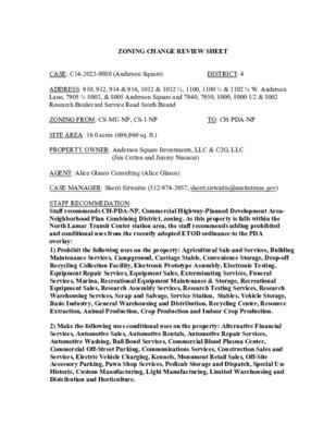
ZONING CHANGE REVIEW SHEET CASE: C14-2023-0080 (Anderson Square) DISTRICT: 4 ADDRESS: 910, 912, 914 & 916, 1012 & 1012 ½, 1100, 1100 ½ & 1102 ½ W. Anderson Lane, 7905 ½ 8003, & 8005 Anderson Square and 7940, 7950, 8000, 8000 1/2 & 8002 Research Boulevard Service Road South Bound ZONING FROM: CS-MU-NP, CS-1-NP TO: CH-PDA-NP SITE AREA: 16.0 acres (696,960 sq. ft.) PROPERTY OWNER: Anderson Square Investments, LLC & C2G, LLC (Jim Cotton and Jimmy Nassour) AGENT: Alice Glasco Consulting (Alice Glasco) CASE MANAGER: Sherri Sirwaitis (512-974-3057, sherri.sirwaitis@austintexas.gov) STAFF RECOMMEDATION: Staff recommends CH-PDA-NP, Commercial Highway-Planned Development Area- Neighborhood Plan Combining District, zoning. As this property is falls within the North Lamar Transit Center station area, the staff recommends adding prohibited and conditional uses from the recently adopted ETOD ordinance to the PDA overlay: 1) Prohibit the following uses on the property: Agricultural Sale and Services, Building Maintenance Services, Campground, Carriage Stable, Convenience Storage, Drop-off Recycling Collection Facility, Electronic Prototype Assembly, Electronic Testing, Equipment Repair Services, Equipment Sales, Exterminating Services, Funeral Services, Marina, Recreational Equipment Maintenance & Storage, Recreational Equipment Sales, Research Assembly Services, Research Testing Services, Research Warehousing Services, Scrap and Salvage, Service Station, Stables, Vehicle Storage, Basic Industry, General Warehousing and Distribution, Recycling Center, Resource Extraction, Animal Production, Crop Production and Indoor Crop Production. 2) Make the following uses conditional uses on the property: Alternative Financial Services, Automotive Sales, Automotive Rentals, Automotive Repair Services, Automotive Washing, Bail Bond Services, Commercial Blood Plasma Center, Commercial Off-Street Parking, Communications Services, Construction Sales and Services, Electric Vehicle Charging, Kennels, Monument Retail Sales, Off-Site Accessory Parking, Pawn Shop Services, Pedicab Storage and Dispatch, Special Use Historic, Custom Manufacturing, Light Manufacturing, Limited Warehousing and Distribution and Horticulture. C14-2023-0080 2 PLANNING COMMISSION ACTION / RECOMMENDATION: February 27, 2024: Postponed to April 9, 2024 at the staff’s request by consent (11-0, F. Maxwell-absent, J. Mushtaler-off the dais); A. Azhar-1st, A. Woods-2nd. April 9, 2024: Approved staff’s request for postponement to May 28, 2024 by consent (12-0, A. Phillips-arrived late); A. Azhar-1st, F. Maxwell-2nd. May 28, 2024: Granted applicant's request for postponement to June 25, 2024 by consent (10-0, P. Howard and A. Phillips-absent, G. Cox-arrived late); F. Maxwell-1st, A. Woods-2nd. June 25, 2024: Approved neighborhood's request for a postponement to August 13, 2024 (7-0, C. Hemple, A. Azhar and A. Haynes-absent, A. Phillips and G. Cox-arrived late); R. Johnson-1st, F. Maxwell-2nd. August 13, 2024: Postponed to August 27, 2024 at the request of the applicant and the neighborhood (12-0, P. Howard-absent); A. Azhar-1st, A. Woods-2nd. August 27, 2024: Postponed to September 24, 2024 by the Planning Commission (8-0-2, J. Mushtaler and R. Johnson-abstain); G. Cox-1st, G. Anderson-2nd. September 24, 2024: Postponed to October 22, 2024 at the request of the applicant on consent (10-0, P. Howard, N. Barrera-Ramirez and F. Maxwell-absent); R. Johnson-1st, A. Woods-2nd. October 22, 2024 CITY COUNCIL ACTION: ORDINANCE NUMBER: C14-2023-0080 ISSUES: N/A 3 CASE MANAGER COMMENTS: The property in question is a 16-acre tract of land that is developed with a retail center that contains several uses, such as Hobby Lobby, a gym (Planet Fitness), an industrial supply company, law offices and a bingo hall. There is commercial zoning (CS-MU-NP, GR-CO- NP, GR-MU-CO-NP, CS-CO-NP, CS-1-MU-NP) and office and commercial uses surrounding the site to the north, south, east and west. The applicant is requesting CH-PDA- NP zoning because they would like to redevelop the site with a mixture of uses that will include housing (please see Applicant's Request Letter- Exhibit C and Applicant's Amended Request Letter-Exhibit D). PROPOSED PDA OVERLAY: Permitted Uses by Right: All permitted and conditional uses under CH zoning are permitted and conditional uses for the subject property. Proposed Site Development Standards: Maximum Height: 120 feet Minimum Lot Size: 20,000 square feet Maximum Floor-To-area Ratio (FAR): 8:1 Minimum Setbacks 0 feet Front Yard: Street Side Yard: 0 feet Interior Side Yard: 0 feet 0 feet Rear Yard: Maximum Building Coverage: 95% Maximum Impervious Cover: 95% Minimum Site Area: None The staff recommends the applicant’s request for CH-PDA-NP, Commercial Highway- Planned Development Area-Neighborhood Plan Combining District, zoning. The property in question meets the intent of the CH base district. This tract of land is located with an established retail center at the northwestern intersection of two arterial roadways, West Anderson Lane and Research Boulevard/U.S. Highway 183. The property is adjacent to commercial zoning to the north, south and west. There is CS-NP and P-NP zoning, across Research Boulevard to the east of the site. As the property under consideration falls within the North Lamar Transit Center station area, the staff recommends prohibiting uses that are not conducive with the goal to encourage market supported development along transit corridors. Therefore, the staff recommends prohibiting the following uses in accordance with the adopted ETOD ordinance on this property: C14-2023-0080 4 INDUSTRIAL USES: Basic Industry General Warehousing and Distribution Recycling Center Resource Extraction AGRICULTURAL USES: Animal Production Crop Production Indoor Crop Production COMMERCIAL USES: Agricultural Sale and Services Building Maintenance Services Campground Carriage Stable Convenience Storage Drop-off Recycling Collection Facility Electronic Prototype Assembly Electronic Testing Equipment Repair Services Equipment Sales Exterminating Services Funeral Services Marina Recreational Equipment Maintenance & Storage Recreational Equipment Sales Research Assembly Services Research Testing Services Research Warehousing Services Scrap and Salvage Service Station Stables Vehicle Storage COMMERCIAL USES: Alternative Financial Services Automotive Sales Automotive Rentals Automotive Repair Automotive Washing Bail Bond Services Commercial Blood Plasma Center Commercial Off-Street Parking Communications Services Construction Sales and Services Electric Vehicle Charging Kennels Monument Retail Sales Off-Site Accessory Parking Pawn Shop Services Pedicab Storage and Dispatch Special Use Historic In addition, the staff recommends that the following uses are conditional uses on the property: INDUSTRIAL USES: Custom Manufacturing Light Manufacturing Limited Warehousing and Distribution AGRICULTURAL USES: Horticulture This property is located within the Wooten Neighborhood Planning Area which was adopted by the Austin City Council on April 1, 2004. A neighborhood plan amendment is required because the future land use map for the Wooten Neighborhood Plan designates this tract (Tract 16) for Mixed Use. The proposed change to the FLUM in associated case NPA-2023-0017.01 is to High Density Mixed Use. C14-2023-0080 5 BASIS OF RECOMMENDATION: 1. The proposed zoning should be consistent with the purpose statement of the district sought. Commercial Highway Services district is intended predominately for major mixed use developments of a service nature which typically have operating and traffic generation characteristics requiring location at the intersection of state maintained highways, excluding scenic arterials. High residential densities are expected. Planned Development Area combining district is intended for combination with selected commercial and industrial base districts, in order to modify base district provisions as necessary to allow for appropriate industrial and commercial uses or to reflect the terms of a Planned Development Area agreement following annexation of properties subject to such an agreement. Neighborhood Plan district denotes a tract located within the boundaries of an adopted Neighborhood Plan. 2. The proposed zoning should promote consistency and orderly planning. The proposed CH-PDA-NP zoning will promote consistency and orderly planning in this area because the property is surrounded by commercial zoning (CS-MU-NP, GR-CO-NP, GR-MU-CO-NP, CS-CO-NP, CS-1-MU-NP) and office and commercial uses to the north, south and west. There is CS-NP and P-NP zoning, across Research Boulevard, to the east of the site. This property is near a designated town center (within 2,00 feet of the Crestview Station) and a neighborhood center (approximately 6,000 feet from the Lamar & Rundberg) as described by the Imagine Austin Comprehensive Plan. 3. Zoning should promote the policy of locating retail and more intensive zoning near the intersections of arterial roadways or at the intersections of arterials and major collectors. This tract of land is located with an established retail center at the northwestern intersection of two arterial roadways, West Anderson Lane and Research Boulevard (U.S. 183). There are numerous transportation options in this area such as a Capital Metro Rapid bus line along N. Lamar Boulevard and Capital Metro bus routes (No. 323) along Research Boulevard, W. Anderson Lane and Anderson Square. There are bus stops adjacent to this property along W. Anderson Lane and Anderson Square. In addition, the site is within walking distance of light rail, Crestview Station and the North Lamar Capital Metro Transit Center. C14-2023-0080 6 EXISTING ZONING AND LAND USES: ZONING Site CS-MU-NP, CS-1-NP North CS-MU-NP South GR-CO-NP, GR-MU- CO-NP, CS-CO-NP East CS-NP, P-NP West CS-MU-NP, CS-1-MU-NP LAND USES Office (DC Law), Retail Center (Planet Fitness, Grainger Industrial Supply, Hobby Lobby, Medical X Press Medical Supply NTB-National Tire & Battery) Automotive Sales (Ranger Motors) Brink Motorsports, Blackerby Violin Shop, Portis Family Chiropractic, Amy’s Ice Cream, Discount Electronics, Uptown Auto Repair, Dell Computers, Scubaland Adventures Auto Sales (Covert Chrysler Dodge Jeep Ram), Capital Metro Park & Ride (North Lamar Transit Center) Retail Center (Crestview Crossing: Cap City Comedy Club, Taekwondo, Crossfit Renew, Fantastic Pool, Computer Nerdz!, The UPS Store, Best Buy Insurance, Boss Nails, Modern Redux, Las Delicias Restaurant, Maids and Moore, Radiante Hair Salon, RNR Tire Express, Vacant Suite), Top Gun Equipment Rentals, Retail Center (Anderson Square: 4 Wheel Parts, Dean Davis Insurance, Balance Staffing, Novel Escape, Morre Hands Maids, Armstrong McCall Beauty Supply, GD4, PFS Auto, psi Test Center, Hanger Clinic), Top Gunn Equipment Rentals NEIGHBORHOOD PLANNING AREA: Crestview/Wooten Neighborhood Planning Area WATERSHED: Little Walnut Creek SCHOOLS: Austin I.S.D. NEIGHBORHOOD ORGANIZATIONS: Austin Independent School District Austin Lost and Found Pets Austin Neighborhoods Council Friends of Austin Neighborhoods Homeless Neighborhood Association Neighborhood Empowerment Foundation North Austin Neighborhood Alliance North Growth Corridor Alliance SELTexas Shoal Creek Conservancy Sierra Club, Austin Regional Group Wooten Neighborhood Assn. Wooten Neighborhood Plan Contact Team C14-2023-0080 CASE HISTORIES: NUMBER C14-2021-0055 (901 & 907 Stobaugh Street) REQUEST SF-3-NP to MF-4-NP COMMISSION 7/27/21: Approved MF-3-CO-NP zoning, with a CO for a 20- dwelling unit maximum (7-0, J. Shieh – recused, C. Llanes-Pulido and J. Mushtaler- abstained, P. Howard, J. Thompson and T. Shaw-absent. C14-2015-0059 (8130 North Lamar) CS-NP to CS-MU-NP 7/14/15: Approved staff’s rec. of CS-MU-NP zoning on consent (12-0); J. Stevens-1st, J. Schissler- 2nd. To grant In Crestview to add V, and to exclude tracts 2, 4, 8 and 11 (35.35 acres) CS-MU-NP to CS-1-MU-NP C14-2009-0065 (Crestview VMU Building Opt-in /Opt-out Process) C14-2009-0044 (The Fault: 8002 Research Boulevard South Bound) 7/14/09: Approved staff’s recommendation of CS-1-MU- NP (7-0); J. Reddy-1st, D. Anderson-2nd. 7 Ordinance CITY COUNCIL 10/14/21: The public hearing was conducted and a motion to close the public hearing and approve No. 20211014-068 to MF-2-CO zoning was approved on Council Member Renteria's motion, Council Member Ellis' second on an 11-0 vote. The additional condition is that the applicant has agreed to limit the number of units to 16. 8/13/15: The public hearing was conducted and the motion to close the public hearing and approve the ordinance on first reading for CS-MU-NP zoning was approved on Council Member Pool’s motion, Council Member Zimmerman’s second on an 11-0 vote. 10/15/15: Ordinance No. 20151015-059 for CSMU-NP zoning was approved on Council Member Gallo’s motion, Council Member Renteria’s second on a 10-0 vote. Council Member Kitchen was off the dais. 9/24/2009: Approved through Ordinance No. 20090924-091 7/23/09: Approved PC rec. of CS-1-MU-NP on first reading (4-3, Morrison, Riley, and Shade- Nay); B. Spelman-1st, S. Cole-2nd. 8/20/09: Approved CS-1-MU- NP on 2nd reading (4-3; Shay, Morrison, and Riley-Nay) 8/27/09: Approved CS-1-MU- NP on 3rd reading (4-3; Shay, Morrison, and Riley-Nay) CS-NP to CS- CO-NP (to allow a Neighborhood Center Special Use on this site and to apply a conditional overlay limiting the property to less than 2,000 vehicle trips per day) Crestview/Woote n Neighborhood Plan Combining District Rezonings C14-2023-0080 C14-07-0007 8 3/13/07: Approved staff’s rec. with added conditions (8-0) 4/12/07: Approved PC rec. of CS-CO-NP zoning (6-0); all 3 readings C14-04-0004 2/10/04: Approved staff’s rec. of NP (6-0) 3/04/04: Approved on 1st reading (6-0) 4/01/04: Approved as granted on 1st reading, with noted exceptions (6-0); 2nd/3rd readings 4/26/01: Approved CS-CO zoning with conditions (7-0); all 3 readings C14-01-0012 SF-3 to CS 3/27/01: Approved staff’s rec. of CS-CO, the conditional overlay will limit the site to less than 2,000 vehicle trips per day (9-0) RELATED CASES: C14-2009-0044 - Previous Rezoning Case C14-2023-0080 9 OTHER STAFF COMMENTS: Comprehensive Planning This parcel falls within the North Lamar Transit Center station area, for which a draft vision plan will go public soon. Work is ongoing for a vision plan. This transit center currently serves multiple bus services, including MetroRapid 801, 1, 350, 323, and 383 routes. It is also identified as a future light rail transit station, as part of a later phase of Project Connect. The application for a CH-PDA-NP zoning is consistent with the density and connectivity in line with the draft vision plan, which recommends high-density mixed use for these parcels. However, a PUD may better meet the neighborhood and city’s desires for transit-supportive income-restricted housing as outlined by the draft vision plan. The proposed mixed-use development is also in line with the Crestview/Wooten Combined Neighborhood Plan, which calls for Mixed-Use as the Future Land Use for this parcel. Environmental The site is not located over the Edwards Aquifer Recharge Zone. The site is located in the Little Walnut Creek Watershed of the Colorado River Basin, which is classified as an Urban Watershed by Chapter 25-8 of the City's Land Development Code. It is in the Desired Development Zone. Zoning district impervious cover limits apply in the Urban Watershed classification. According to floodplain maps there is no floodplain within or adjacent to the project location. Standard landscaping and tree protection will be required in accordance with LDC 25-2 and 25-8 for all development and/or redevelopment. At this time, site specific information is unavailable regarding vegetation, areas of steep slope, or other environmental features such as bluffs, springs, canyon rimrock, caves, sinkholes, and wetlands. This site is required to provide on-site water quality controls (or payment in lieu of) for all development and/or redevelopment when 8,000 sq. ft. cumulative is exceeded, and on site control for the two-year storm. At this time, no information has been provided as to whether this property has any preexisting approvals that preempt current water quality or Code requirements. Fire No comments. C14-2023-0080 Parks and Recreation 10 Parkland dedication will be required at the time of subdivision or site plan application for new residential units proposed by this rezoning, multifamily with CH-PDA-NP, per City Code § 25-1-601, as amended. The intensity of the proposed development creates a need for over six acre of additional parkland, per requirements described in § 25-1-602; when over six acres, parkland must be dedicated – see § 25-1-605 (A)(2)(a). As such, land dedication shall be required, unless the land available for dedication does not comply with the standards for dedication. Any remaining fees in-lieu after dedication shall also be required. If the land available for dedication complies with the parks standards, the Parks and Recreation Department (PARD) would consider a small park toward satisfying the requirement at time of permitting (whether subdivision or site plan). The surrounding neighborhood areas are currently park deficient, defined as being outside walking distance to existing parks. The dedication would satisfy the need for additional parks in park deficient areas of North Central Austin, a specific recommendation in the Parks and Recreation Department’s Long Range Plan. Should there be any remaining fees in-lieu, those fees shall be used toward park investments in the form of land acquisition and/or park amenities within the surrounding area, per the Parkland Dedication Operating Procedures § 14.3.11 and City Code § 25-1-607 (B)(1) & (2). If the applicant wishes to discuss parkland dedication requirements in advance of site plan or subdivision applications, please contact this reviewer: thomas.rowlinson@austintexas.gov. At the applicant’s request, PARD can provide an early determination letter of the requirements. Site Plan A site plan will be required for any new development other than single-family, two-family or duplex residential. Any new development is subject to the design standards in Subchapter E of the Land Development Code. Additional comments will be made when the site plan is submitted. Generally, any development which occurs in an SF-6 or less restrictive zoning district which is located 540 ft. or less from property in an SF-5 or more restrictive zoning district will be subject to compatibility development regulations, per § 25-2-1051. However, this site is along Research Blvd and Anderson Lane, which are considered large and medium corridors per Ordinance No. 20221201-056, and thus, are subject to less restrictive compatibility standards for residential or mixed-use properties. See https://publicinput.com/CompatibilityCorridorsFAQ for more information. C14-2023-0080 11 In the event that demolition or relocation of existing buildings are proposed, the applicant is responsible for requesting demolition or relocation permits at the appropriate stage of the development process. The City Historic Preservation Office will review all proposed building demolitions and relocations. If a building meets city historic criteria, the Historic Landmark Commission may initiate a historic zoning case on the property. This site is located in the Wooten Neighborhood Plan. Please see the City’s Neighborhood Plans and Resources webpage for a copy of the recommended design guidelines. Transportation The Austin Strategic Mobility Plan (ASMP) calls for 58 feet of right-of-way for Anderson Sq. Dedicate 29 feet of right-of-way from the existing centerline with the first subdivision or site plan application. [LDC 25-6-51 and 25-6-55]. The Austin Strategic Mobility Plan (ASMP) calls for 116 feet of right-of-way for W Anderson Ln. Dedicate 58 feet of right-of-way from the existing centerline with the first subdivision or site plan application. [LDC 25-6-51 and 25-6-55]. Research Blvd is a TXDOT roadway. Coordination on ROW requirements with TXDOT will be required during first subdivision or site plan application. A Zoning Traffic Analysis (ZTA) was conducted for the site and the Memo, with recommendations, is included as Exhibit E. The adjacent street characteristics table is provided below: Name ASMP Classification ASMP Required ROW Existing ROW Existing Pavement Sidewalks Bicycle Route Capital Metro (within ¼ mile) 58 80 60 Partial None Yes 116 81 56 Yes No Yes Anderson Square Level 1 – Residential Collector/Local W. Anderson Ln. Level 3 – Minor/Major Arterial C14-2023-0080 12 Research Blvd. Level 4 - 400 394 no No Yes Principle/Major Arterial NA (TXDOT) Water Utility No comments on zoning change. FYI: The landowner intends to serve the site with City of Austin water and wastewater utilities. The landowner, at own expense, will be responsible for providing any water and wastewater utility improvements, offsite main extensions, utility relocations and or abandonments required by the land use. The water and wastewater utility plan must be reviewed and approved by Austin Water for compliance with City criteria and suitability for operation and maintenance. Depending on the development plans submitted, water and or wastewater service extension requests may be required. All new development within the proposed project will be subject to City Code Chapter 25-9 and any future amendments relating to reclaimed water connections, water benchmarking, and mandatory onsite water reuse. All water and wastewater construction must be inspected by the City of Austin. The landowner must pay the City inspection fee with the utility construction. The landowner must pay the tap and impact fee once the landowner makes an application for a City of Austin water and wastewater utility tap permit. INDEX OF EXHIBITS TO FOLLOW A: Zoning Map B. Aerial Map C. Applicant’s Request Letter D. Applicant's Amended Request Letter E. Zoning Traffic Analysis Memorandum F. Correspondence Received ( ( W O O TE ( SF-3-NP ( ( N D R N Y L Z A L ( ( SF-3-NP ( ( P-NP WOOTEN ELEMENTARY SCHOOL ( ( ( ( ( ( ( ( R E D L A D TIS ( ( = ( ( N Y L Z LA ( ( ( ( ( ( ( ( SF-3-NP = ( ( ( ( ( ( ( ( ( ( ( D ALE D R ( ( MF-3-NP ( ( ( ( SF-3-NP ( ( ( ( ( ( ( ( ( ( MF-4-NP D ALE D R SP95-0394C CHURCH GO-CO-NP S P 8 8 - 0 3 5 7 C SP96-0054C ( R D E IN A M ( ( C14-07-0007 R E S E A R C H B L V 6 9 - 3 0 4 S P 9 4 - 0 1 0 5 C CS-NP P 8 5 - 0 2 3 D S V R D N B S P 8 9 - 2 3 2 C CS-CO-NP 12 0 01-0 S P - 0 5 - 1 4 5 9 C ( ( ( ( ( ( ( ( ( ( ( EXHIBIT A SF-3-NP ( ( ( ( ( ( BANGOR BND ( ( ( ( ( ( ( SF-3-NP ( ( ( ( ( ( ( ( ( ( MH PARK MH-NP C14-2019-0083 CAR DEALERSHIP MH PARK CS-CO-NP R E S E A R C H B L V D S V R D S B R85-127 ( ( ( ( ( ( R84-315 SF-3-NP ( ( CS-1-MU-NP R E S E A R C H N B T O A N D E R S O N R A M P MF-4-NP 66-123 S T N E M T R PA A 66-123 TIRE CO. ! ! 71-186 GR-CO-NP TV\REPAIR APTS. GR-MU-CO-NP GR-CO-NP R E T N E N\C E D R A G ( ( SF-3-NP ( ( ( ( ( ( N U R SIN ( G\H ( O M E OFC. GR-CO-NP PA R K GR-MU-CO-NP ( SF-3-NP ( ( ( ( ( SF-3-NP ( ( ( ( ( 84-465 ( ( ( ( ( ( ( ( ( ( ( ( ( SF-3-NP ( ( ( ( ( ( ( ( ( ( ( ( ( ( 81-236R C ( ( ( ( LO-MU-NP ( 79-138 ( ( ( ( T LT S ( U A G ( ( ( ( ( ( ( ( ( CS-CO-NP TAILO R C. E O EL AIR P E R GR-CO-NP T U A P O H S 9 0 72-2 SF-3-NP ( ( ( ( ( ( ( ( ( ( ( ( ( ( ( ( ( ( ( ( ( FOOTBALL DIAMOND ( ( SF-3-NP ( ( ( ( ( ( ( ( ( ( ( SF-3-NP ( ( ( ( ( M O R R O ( ( W S T ( SP89-0164BS LI-PDA-NP ( ( ( ( = = = = ( ( ( ( ( ( ( ( SP-99-2017CS ! ! ! ! ! FA ST F ! O O D ! ! 2009-0044 ! ! CS-1-MU-NP C14-2009-0044 ! CS-MU-NP R E T N E G C PIN P O H S ! Q N S O S R E D N A ! ! ! ! R E S E A R C H S B T O L ! A ! ! ! ! ! ! ! ! ANDERSON SQUARE SHOPPING CENTER CS-MU-NP 66-123 RZ85-082 A N M A D E R R S S ! ! ! ! R E S E V O R N D S R Q R E S E A R C H A R C H A T M O P A N L A M A R S ! ! ! B L V N D B L V E D R S O S B D N B ! ! ! ! ! ! PAIR E V R T ( ( ( T N S O S T A W = ! ! ! C. F R. O D DISCO ! ! ! GR-MU-CO-NPGR-CO-NP B O T TLIN G\C O ( ( ( 72-291 ( SF-3-NP 72-193 ( ( H S T ST O B A U G ( = = ( ( ( ( ( SF-3-NP N L N E B R A M P ! ! ! ! ! ! ! ! ! ! ! ! ! W A ! N D E OFC. 71-204 ! R S O ! N LN ! ! O F C. 2 0 73-2 ( CS-CO-NP ! ! ! ! ! ! ! S WIM MIN 9 1 G\P O OL\S U PPLY C14-2009-0065 ( 84-0 70-025 75-112 ( LO-MU-CO-NP ( ( 6 6 69-1 ( 69-139 ( ( ( ( ( NPA-2021-0017.02 C14-2021-0055 MF-2-CO-NP C 21 1 P-99-0 S ( 67-163 MF-3-NP C14-2009-0065 CS-MU-V-CO-NP C 59 0 P-02-0 S N L A M A R S B T O A N D E R S O N W B R A M P B D N R V D S R BLV 74-13 C14-01-0037 CS-NP RZ85-022 AUTO SALES 86-041 OFFICE WHSE 79-183 P RINTIN G C O. MINI STO R A G E 79-122 CS-MU-NP C14-2015-0059 NPA-2015-0007.01 B R E S E A R C H N B R A M P R86-104/P86-014 P-NP 67-068 B D S R BLV A M N LA A U T O GLA SS APARTMENTS C14-2010-0049 CS-MU-V-CO-NP NP-2010-0026 W A N D E R S O N L W A N D E R S O N S V R D W B N LN W B W ANDERSON LN EB W ANDERSON LN SVRD EB ( ( ( SF-3-NP ( TA U LB E ( ( E LN ( ( ( ( ( ( ( NPA-2008-0017.01 C14-2008-0030 ( ( MF-3-NP ( NPA-2020-0017.02 C14-2020-0047 CS-MU-CO-NP ( ( ZONING B D N LV R B A M A N L A M A N L B D S R V D S V L R B A M A N L CS-MU-V-NP C14-2009-0012 P83-118 82-128 78-194 CS-1-MU-V-NP 71-155 83-255 ZONING CASE#: C14-2023-0080 ± SUBJECT TRACT ! ! ! ! ! ! PENDING CASE ZONING BOUNDARY This product is for informational purposes and may not have been prepared for or be suitable for legal, engineering, or surveying purposes. It does not represent an on-the-ground survey and represents only the approximate relative location of property boundaries. 1 " = 400 ' This product has been produced by the Housing and Planning Department for the sole purpose of geographic reference. No warranty is made by the City of Austin regarding specific accuracy or Created: 6/20/2023 EXHIBIT B !!!!!!!!!!!!!!!!!!!!!!!!!!!!!!!!!!!!!!!!!!!!!!!!!!!!!!!!!!!!!!!!!!!!!!!!!!!!!!!!!!!!!!!!!!!!!!!!!!!!!!!!!!!!!!!!!!!!!!!!!!!!!!!!!!!!!!!!!!!!!!!(!(!(!(!(!(!(!(!(!(!(!(!(!(!(!(!(!(!(!(!(!(!(!(!(!(!(!(!(!(!(!(!(!(!(!(!(!(!(!(!(!(!(!(!(!(!(!(!(!(!(!(!(!(!(!(!(!(!(!(!(!(!(!(!(!(!(!(!(!(!(!(!(!(!(!(!(!(!(!(!(!(!(!(!(!(!(!(!(!(!(!(!(!(!(!(!(!(!(!(!(!(!(!(!(!(!(!(!(!(!(!(!(!(!(!(!(!(!(!(!(!(!(!(!(!(!(!(!(!(!(!(!(!(!(!(!(!(!(!(!(!(!(!(!(!(!(!(!(!(!(!(!(!(!(!(!(!(!(!(!(!(!(!(!(!(!(!(!(!(!(!(!(!(!(!(!(!(!(!(!(!(!(!(!(!(!(!(!(!(!(!(!(!(!(!(!(!(!(!(!(!(!(!(!(!(!(!(!(!(!(!(!(!(!(!(!(!(!(!(!(!(!(!(!(!(!(!(!(!(!(!(!(!(!(!(!(!(!(!(!(!(!(!(!(!(!(!(!(!(!(!(!(!(!(!(!(!(!(!(!(!(!(!(!(!=!=!=!=!=!=!=!=!=K29C14-2023-0080C14-01-0037NP-2010-0026C14-2010-0049C14-2009-0012C14-2019-0083C14-2009-0065C14-2009-0065C14-07-0007C14-2021-0055NPA-2021-0017.02C14-2015-0059NPA-2015-0007.01C14-2009-0044C14-2008-0030NPA-2008-0017.01C14-2020-0047NPA-2020-0017.02GAULTSTLAZYLNTISDALEDRTAULBEELNSTOBAUGHSTRESEARCHBLVDSBRESEARCHBLVDNBNLAMARBLVDSBWANDERSONLNWATSONSTNLAMARBLVDNBRESEARCHBLVDSVRDSBWOOTENDRANDERSONSQRESEARCHBLVDSVRDNBNLAMARBLVDSVRDSBMORROWSTNLAMARBLVDSVRDNBBANGOR BNDRESEARCHSBTOLAMARSVRDRAMPANDERSONSQTOANDERSONLNEBRAMPNLAMARSBRESEARCHNBRAMPDALEDRRESEARCHNBTOANDERSONRAMPWANDERSONLNEBWANDERSONLNWBWANDERSONLNSVRDEBWANDERSONLNSVRDWBNLAMARSBTOANDERSONWBRAMPMAINEDRLAZYLNDALEDRCS-NPP-NPCS-MU-NPP-NPCS-MU-NPMH-NPSF-3-NPSF-3-NPSF-3-NPSF-3-NPCS-MU-V-NPSF-3-NPMF-3-NPSF-3-NPSF-3-NPCS-CO-NPSF-3-NPLI-PDA-NPSF-3-NPSF-3-NPCS-MU-V-CO-NPGO-CO-NPCS-NPSF-3-NPSF-3-NPCS-CO-NPSF-3-NPSF-3-NPGR-CO-NPMF-4-NPCS-MU-V-CO-NPSF-3-NPSF-3-NPMF-2-CO-NPMF-3-NPGR-CO-NPMF-4-NPMF-3-NPCS-MU-NPGR-MU-CO-NPGR-CO-NPCS-CO-NPGR-MU-CO-NPLO-MU-CO-NPGR-MU-CO-NPGR-CO-NPCS-MU-CO-NPCS-CO-NPGR-CO-NPLO-MU-NPCS-1-MU-V-NPCS-1-MU-NPCS-1-MU-NPSF-3-NPAnderson Square±This product has been produced by the Planning Department for the sole purpose of geographic reference. No warrantyis made by the City of Austin regarding specific accuracy or completeness.ZONING CASE#:LOCATION:SUBJECT AREA:GRID:MANAGER:C14-2023-0080910, 912, 914, 916, 1012, 1012 1/2, 1100,1100 1/2,1102 1/2 W Anderson Ln; 7905 1/2,8003, 8005 Anderson Sq; 7940, 7950, 8000,8000 1/2, 8002 Research Blvd Svrd SB16 AcresK29Sherri SirwaitisCreated: 7/25/2023SUBJECT TRACTZONING BOUNDARY!!!!!!PENDING CASECREEK BUFFER0200400600800100Feet EXHIBIT C ALICE GLASCO CONSULTING June 14, 2023 Lauren Middleton-Pratt, Director Planning Department 1000 E. 11th Street, Suite 200 Austin, Texas 78702 RE: Anderson Square Dear Ms. Middleton-Pratt: I represent Anderson Square Investments, LLC and C2G, LLC, the owners of the property bounded by Anderson Lane, Research Blvd. SVRD SB, and Anderson Square in the rezoning of the property and in amending the Future Land Use Map (FLUM) of the Crestview/Wooten Neighborhood Plan. The current rezoning is CS-MU-NP, and CS-1-MU-NP and the requested rezoning is CH-PDA-NP. The change to the FLUM is from Mixed Use to High Density Mixed Use. Current State: The subject site is currently developed with several uses, namely, Hobby Lobby, a gym (Planet Fitness), an industrial supply company, law offices and a bingo hall. Crestview/Wooten Neighborhood Plan: Land Use Goal 5: Promote enhancement of major corridors by encouraging better quality and a mix of neighborhood serving development and redevelopment and discouraging strip development. Rationale: the redevelopment of this 16-acre site will include commercial and multifamily housing, which will add to the diversity of housing in the Crestview/Wooten planning area. Land Use Objective 3: Allow more intense commercial uses to locate on Research Boulevard, while minimizing the impacts to any nearby residential uses. Rationale: Given the location of this 16-acre site, future redevelopment will enhance and not adversely impact nearby residential uses. 1 The proposed PDA standards for the subject property would be as follows a. All permitted and conditional uses under CH zoning are permitted and conditional uses for the subject property. The following site development standards shall apply to the property: 1. The maximum height is 250 feet 2. The minimum lot size is 5,750 square feet 3. The maximum floor-to-area ratio is 8 to1 4. The minimum front yard setback is 0 feet 5. The minimum street side yard setback is 0 feet 6. The minimum interior side yard setback is 0 feet 7. The minimum rear yard setback is 0 feet 8. The maximum building coverage is 95% 9. The maximum impervious cover is 95% Justification for FLUM change and rezoning: • Redevelopment opportunity: the proposed rezoning will allow the approximately 16-acre site to be creatively master-planned, with a mix of uses that will include housing. • • Imagine Austin Comprehensive Plan Corridors: the site is bounded by West Anderson Lane and North Lamar Boulevard – Imagine Austin Corridors and a major thoroughfare, namely Research Blvd. Imagine Austin Comprehensive Plan Centers: the site is in close proximity to a town center (Crestview Station), a neighborhood center (Lamar & Rundberg) and a job center (Cameron & 183 Center). • Proximity to transit: the site is within walking distance of light rail - Crestview Station, and the North Lamar Capmetro Transit Center. Additionally, there is a bust stop on West. Anderson Lane, in front of the subject property. 2 3 Please let me know if you have any questions or need additional information. Sincerely, Alice Glasco, President AG Consulting Cc: Jim Cotton, Anderson Square, LLC Jimmy Nassour, C2G, LLC EXHIBIT D ALICE GLASCO CONSULTING April 21, 2023 Updated May 2, 2024 Joi Harden, Interim Zoning Officer Planning Department 1000 E. 11th Street, Suite 200 Austin, Texas 78702 RE: Anderson Square Dear Ms. Harden: I represent Anderson Square Investments, LLC and C2G, LLC, the owners of the property bounded by Anderson Lane, Research Blvd. SVRD SB, and Anderson Square in the rezoning of the property. The current rezoning is CS-MU-NP, and CS-1-MU-NP and the request is for CH-PDA-NP. This letter has been updated to reduce the building height from 250 feet to 120 feet, which is what CH zoning allows. Background: The subject site is currently developed with several uses, namely, Hobby Lobby, a gym (Planet Fitness), an industrial supply company, law offices and a bingo hall. The proposed PDA standards for the subject property would be as follows a. All permitted and conditional uses under CH zoning are permitted and conditional uses for the subject property. The following site development standards shall apply to the property: 1. The minimum lot size is 20,000 square feet 2. The maximum floor-to-area ratio is 8 to1 3. The maximum height is 120 feet (as allowed under CH zoning) 4. The minimum front yard setback is 0 feet 5. The minimum street side yard setback is 0 feet 6. The minimum interior side yard setback is 0 feet 7. The minimum rear yard setback is 0 feet 1 2 8.The maximum building coverage is 95%9.The maximum impervious cover is 95%Justification for rezoning: •Redevelopment opportunity: the proposed rezoning will allow theapproximately 16-acre site to be creatively master-planned, with a mix of usesthat will include housing.•Imagine Austin Comprehensive Plan Corridors: the site is bounded by WestAnderson Lane and North Lamar Boulevard – Imagine Austin Corridors and amajor thoroughfare, namely Research Blvd.•Imagine Austin Comprehensive Plan Centers: the site is in close proximity toa town center (Crestview Station), a neighborhood center (Lamar & Rundberg)and a job center (Cameron & 183 Center).•Proximity to transit: the site is within walking distance of light rail - CrestviewStation, and the North Lamar Capmetro Transit Center. Additionally, there is abust stop on West. Anderson Lane, in front of the subject property and the site isalso in proximity to the future light rail extension of transit connect, phase 2. Please let me know if you have any questions or need additional information. Sincerely, Alice Glasco, President AG Consulting Cc: Jim Cotton, Anderson Square, LLC Jimmy Nassour, C2G, LLC EXHIBIT E MEMORAN DUM From: To: Date: Subject: Nathan Aubert, P.E. Amir Jafari, PhD, PE, PTOE February 26, 2024 910-916 W. ANDERSON LN. – Zoning Transportation Analysis The Transportation Development Services (TDS) Division has reviewed the February 6, 2024, “910-916 W. Anderson Ln. Zoning Transportation Analysis”, prepared by LJA. The proposed land uses consist of residential, retail, hotel, and office buildings. The site is located at 910-916 W. Anderson Lane, 1100 &.1012 &1012 1/2 W. Anderson Lane, 8000 Research Blvd. in Austin, Texas as depicted in Figure 1 below. Site access will consist of three right-in, right-out driveways: two along IH-35 NBFR, and one on US 290 WBFR. The development is anticipated to be constructed in one phase to be completed in 2028. Figure 1. Site Location Page 1 of 4 Roadways Anderson Square The Austin Strategic Mobility Plan (ASMP) classifies Anderson Sq. as a Level 1 with 2 travel lanes in the vicinity of the site. According to TxDOT average daily traffic counts, the 2019 ADT was approximately 9,407 vehicles per day (vpd). 24 hours data were collected along this route on Tuesday, December 5th, 2023. The ADT was 12,894 (vpd). The posted speed limit is 35 mph. The ASMP envisions sidewalks at this location. Improvements will be made within the existing ROW using flexible design criteria. Right-of-Way (ROW) dedication may be required from new development and commercial redevelopment through the land development process. West Anderson Lane The ASMP classifies W Anderson Ln as operating with 4 travel lanes and a raised median (Level 3) in the vicinity of the site. According to TxDOT average daily traffic counts, the 2020 ADT was approximately 9,179 vehicles per day (vpd). 24-hour data was collected along this route on Tuesday, December 5th, 2023. The ADT was 12,628 vpd. The posted speed limit is 35 mph. The ASMP identifies adding a raised median, consolidating driveways, and all ages and abilities bicycle facilities. Protected bicycle lanes are recommended for the future. Research Blvd The ASMP classifies Research Blvd as a three-lane one-way road (Level 4) in the vicinity of the site. According to TxDOT average daily traffic counts, the 2022 ADT was approximately 11,740 vehicles per day (vpd). 24 hours data were collected along this route on Tuesday, December 5th, 2023. The ADT was 6,301 vpd. The posted speed limit is 45 mph. ASMP recommendations include long-term improvements to bicycle facilities only. Trip Generation and Traffic Analysis The project assumes 1,376 mid-rise multi-family dwelling units (ITE Code 221), 1,009 high-rise multi-family dwelling units (ITE Code 222), 600 hotel rooms (ITE Code 312), 552,750 square-feet of general office building (ITE Code 710). 80,000 square-feet of retail (variety store, ITE Code 814), and 552,750 square-feet of shopping center (ITE Code 820). Based on the Institute of Transportation Engineer’s Trip Generation Manual, 11th Edition, the proposed development will generate 23,529 vehicle trips per day. See Table 1 for a detailed breakdown of the trip generation. Table 1. Trip Generation Land Use Size 221 - Multifamily Housing (Mid Rise) 222 - Multifamily Housing (High Rise) 312 - Business Hotel 710 - General Office Building 814 - Retail (Variety Store) 820 - Retail (Shopping Center > 150 k) 1,376 Dwelling Units 1,009 Dwelling Units 600 rooms 552,750 square-feet 80,000 square-feet 552,750 square-feet Total Unadjusted Trips Existing Trips TDM Trips (20% Reduction) Net New Trips Trip Generation (Daily) 6,517 4,581 2,412 5,992 5,093 20,457 45,052 12,513 9,010 23,529 Page 2 of 4 The existing trips were obtained from tube count data, then site trips were added to these volumes using an estimate of the traffic distribution to and from the proposed site. Table 2 shows both the existing traffic volumes as well as projected volumes on each road in the vicinity of the site. Table 2. Added Traffic Street ANDERSON SQUARE RESEARCH BLVD W ANDERSON LANE Existing Traffic [vpd] 12,894 6,301 12,628 Proposed New Site Traffic to each Roadway 1,293 1,724 1,293 Overall Traffic (Existing + Site) [vpd] 14,187 8,025 13,921 Percentage Increase in Traffic 10% 27.4% 10.2% Recommendations/Conclusions As a condition for approval for the above referenced zoning review case, the applicant shall adhere to the following requirements: 1. Provide no more than two driveways proposed along Research Blvd. Both driveways will operate as right-in, right-out. Final approval will be given by TxDOT as the site is directly accessing TxDOT roadways. 2. Provide no more than one driveway along W. Anderson Ln. This driveway will operate as full purpose. The driveway will be further reviewed during the site plan process by appropriate City departments and will be subject to adherence with the Transportation Criteria Manual (TCM). 3. Provide no more than two driveways along Anderson Sq. This driveway will operate as full purpose. The driveway will be further reviewed during the site plan process by appropriate City departments and will be subject to adherence with the Transportation Criteria Manual (TCM). 4. The applicant has committed to achieving a trip reduction of 20% through Transportation Demand Management (TDM) measures. The final determination of TDM measures proposed by the applicant, as well as a sustainable modes analysis will be provided during the Site Plan review process. 5. The City of Austin reserves the right to reevaluate any or all identified improvements associated with this case at the time of Site Plan review. 6. Street Impact Fee (SIF) Ordinances 20201220-061 and 20201210-062 have been adopted by City Council and are effective as of December 21, 2020. The City has started collecting street impact fees with all building permits issued on or after June 21, 2022. For more information, please visit the City’s Street Impact Fee website. A Street Impact Fee calculation shall be performed at the time of the Site Plan submission to be collected at the time of building permit. Page 3 of 4 7. All construction items should be designed and incorporated into the site plan, and all street impact fees should be paid in full. No offsets to the proposed development’s SIF will be issued until completion of all identified construction items unless those items are included in the proposed Site Plan application. If you have any questions or require additional information, please contact me at (512) 974-7136. Nathan Aubert, P.E. Austin Transportation Department Page 4 of 4 EXHIBIT F Wooten Neighborhood Plan Contact Teams Request for Anderson Square Rezoning CASE: C14-2023-0080 (Anderson Square) The owners of the property at the North East corner of Anderson Square and Anderson Lane are seeking to rezone it to a Planned Development Agreement with a 250-foot height limit. This site, at the corner of US Hwy183, North Lamar and Anderson Lane, is the nexus of many current and future transportation routes. It’s across the highway from the North Lamar Transit Center, which serve’s Cap Metro’s most popular bus route, the 1/801, and will be the future Project Connect Terminus. At just a half-mile from a future section of the Red Line Parkway and Trail and ¾ mile from the Red Line stop at Crestview Station, this site will be a great place to live with many different transportation options to access large chunks of Austin. The Wooten Neighborhood Contact Team will support the rezoning request provided an agreement can be reached that will place a restrictive covenant on the property that will make the property a more walkable, enjoyable place to spend time and ensuring that it contributes to the improvement of nearby amenities that will help accommodate all the new residents, improve the neighborhood, and increase the value of the property to the owners. At 16 acres, this site is large enough to be a great community destination, with huge potential for much-wanted retail and pleasant outdoor spaces within walking distance from both the Wooten and Crestview Neighborhoods. At 250 feet in height, this will double the household size of the Wooten neighborhood and attract many retail uses that may not have been a good fit for the site in its current form and neighborhood population. Of greatest interest to the Wooten Neighborhood is a grocery store. Adding so many people to the neighborhood will add many benefits, but if they all come with cars and people only visit the new development in cars it could be a liability rather than an asset. The Contact Team has spent many weeks formulating requests to make this site's open spaces as pleasant as possible to visit via foot or bike, even in the often unpleasantly hot Austin climate. We want to include not only many of the traditional walkable ingredients such as reconnecting the grid, building a car free paseo, creating interesting, easily navigable and active sidewalks, but to also really tackle the summer heat problem. Shadows from the tall buildings will help, but to ensure year-round walkability, shielding from intense western sun exposure calls for both physical structures to provide shade, and trees to provide shade and add a cooling effect(as much as 1.6℃). Finally, we must preserve a special neighborhood character: the Pink Gorilla. Transportation Infrastructure and Place Making ● Reconnect the grid at Dale and Watson ○ Add signalized crossing infrastructure for bikes and pedestrians, and if resources allow cars ● Create a Car-free paseo with great placemaking ○ Incorporate this into dedicated park land ○ Install placemaking structures at either end and in the center of the paseo ■ Preferred location for the Pink Gorilla ● Embrace Anderson Lane/Square ○ Use Core Transit Corridor Sidewalk requirements and Retail/Commercial fronting both Anderson Lane and Anderson Square ○ Buildings incorporate continuous active frontages (doors, large engaging windows, architectural detailing, etc.) ○ Zero front building setbacks ○ Wide sidewalks of at least 10’ ○ 100% of the sidewalk is shaded when the sun is directly overhead, using physical structures such as building overhang, awnings,etc, plus trees.(see photo example) ○ Do not allow overhead utilities over sidewalks to increase tree and shade structure capacity. Either bury utilities over sidewalks or place them overhead in different locations ● Internal Circulators Streets ○ Design speed of 10 mph for cars to improve pedestrian safety ○ No curbs ○ 100% of the sidewalk is shaded when the sun is directly overhead, using physical structures such as building overhang, awnings,etc, plus trees.(see photo example) ○ Use whichever creates a better pedestrian environment Subchapter E or Great Streets ○ Do not allow overhead utilities over sidewalks to increase tree and shade structure capacity. Either bury utilities over sidewalks or place them overhead in different locations ● Red Line Parkway Improvement ○ Upon issuance of a site plan permit, provide a $250,000 contribution to the Red Line Parkway Initiative to support the design and planning of the Parkway between Crestview Station and McKalla Station, and of connections between the development and the Parkway. ○ To address the possibility of separate site plan permits within the development, suitable fractions can be applied based on each parcel’s percentage of the total area, while ensuring that the total reaches 100%. ● Support CapMetro Operations ○ Fund a permanent shade structure for 323 Bus Westbound and Eastbound stops on Anderson Lane and Anderson Square ○ Consult with CapMetro on Bike share stations integration ● Parking and Cars ○ Car Parking ■ 100% underground parking ■ For residential tenants parking shall be unbundled from housing units. A parking spot shall not be included with a housing lease and a separate lease for parking for residents will be necessary should they desire parking ○ Have secured and covered Bike Parking ○ Achieve greater than average car trip reduction at site plan. ● Achieve diversity of street frontage and uses ○ Maximum lot width should be 75 feet on at least part of the project to create a diversity of buildings within that area. ○ Block perimeter limit of 1500 linear feet or less, ● Street Impact Fees Offset ● If the following improvements have not already been done by the city at the time when the Owner is required to pay Street Impact Fees, the Owner will enter an agreement with the city to make the improvements themselves for an offset to the fee ○ Removal of slip lanes and creating a new, straighter Anderson Square signalized intersection at Anderson Lane. ○ Upgrades to the left turn on the east side of Anderson Lane used to access the 183 Southbound frontage road intersection. Prohibited Uses Incorporate the Planning Department Staff Recommendation on Prohibited Uses: As this property is falls within the North Lamar Transit Center station area, the staff recommends adding prohibited and conditional uses from the recently adopted ETOD ordinance to the PDA overlay: 1) Prohibit the following uses on the property: Agricultural Sale and Services, Building Maintenance Services, Campground, Carriage Stable, Convenience Storage, Drop-off Recycling Collection Facility, Electronic Prototype Assembly, Electronic Testing, Equipment Repair Services, Equipment Sales, Exterminating Services, Funeral Services, Marina, Recreational Equipment Maintenance & Storage, Recreational Equipment Sales, Research Assembly Services, Research Testing Services, Research Warehousing Services, Scrap and Salvage, Service Station, Stables, Vehicle Storage, Basic Industry, General Warehousing and Distribution, Recycling Center, Resource Extraction, Animal Production, Crop Production and Indoor Crop Production. 2) Make the following uses conditional uses on the property: Alternative Financial Services, Automotive Sales, Automotive Rentals, Automotive Repair Services, Automotive Washing, Bail Bond Services, Commercial Blood Plasma Center, Commercial Off-Street Parking, Communications Services, Construction Sales and Services, Electric Vehicle Charging, Kennels, Monument Retail Sales, Off-Site Accessory Parking, Pawn Shop Services, Pedicab Storage and Dispatch, Special Use Historic, Custom Manufacturing, Light Manufacturing, Limited Warehousing and Distribution and Horticulture. Affordable Housing Follow the new Affordable Housing guidelines for Planned Development Agreement zoning passed by Council on July 18, item 91 exhibit A and summarized below. - - - 60 feet in height must 10% Affordable at 60 MFI 90 feet in height must be 12% Affordable at 60 MFI or 10% Affordable at 50 MFI 120 feet in height must be 15% Affordable at 60 MFI or 12% Affordable at 50 MFI Business and Storefronts ● Encourage Local Businesses ○ Make a good-faith attempt to have at least 50% local businesses occupy the commercial spaces. If a storefront cannot be leased for 6 months, it is exempt from this requirement ● Encourage Grocery Store ○ Provide a space suitable for a grocery store and attempt to find a grocery store tenant. This space would be exempt from the local business, block perimeter and lot width requirements above. If no grocery store tenant can be found and the grocery store location is vacant for 24 months it can be filled with any tenant Parks and Environment ● Use detention pond requirements to create a walkable green belt connecting parts of the development. Please see The Triangle, Central Park, and Mueller for good examples ● Land dedicated for Parkland should have maintenance funded by the owner ● Solar Panels shall be incorporated on all roofs ● All buildings shall have rainwater collection ● Residential buildings shall have advanced air filtration systems to remove highway ○ Upon issuance of a site plan permit, fund the following improvements to Wooten pollution from housing units ● Wooten Park Improvements Park ■ Splash Pad ■ Grills ■ Bird Feeders and seed ■ Permanent Soccer Set Up ■ Combo Water Fountains ■ Work Out Area ■ Off-Leash Dog Area ■ Toddler Play equipment ○ To address the possibility of separate site plan permits within the development, suitable fractions can be applied based on each parcel’s percentage of the total area, while ensuring that the total reaches 100%. Safe Streets Austin Safe Streets Austin is assisting us in creating and reviewing and being a party to the restrictive covenant. The owner will give Safe Streets $5,000 for their assistance. Pink Gorilla Incorporate the Pink Gorilla into the site, preferably in the car-free paseo or donate to the City of Austin’s Park Department for placement in Wooten Neighborhood Park.