04 NPA-2023-0017.01 - Anderson Square, District 4 Staff Report — original pdf
Backup
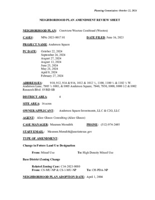
Planning Commission: October 22, 2024 NEIGHBORHOOD PLAN AMENDMENT REVIEW SHEET NEIGHORHOOD PLAN: Crestview/Wooten Combined (Wooten) CASE#: PROJECT NAME: Anderson Square PC DATE: October 22, 2024 NPA-2023-0017.01 DATE FILED: June 16, 2023 September 24, 2024 August 27, 2024 August 13, 2024 June 25, 2024 May 28, 2024 April 9, 2024 February 27, 2024 4 910, 912, 914 & 916, 1012 & 1012 ½, 1100, 1100 ½ & 1102 ½ W. ADDRESS/ES: Anderson Lane; 7905 ½ 8003, & 8005 Anderson Square; 7940, 7950, 8000, 8000 1/2 & 8002 Research Blvd. SVRD SB DISTRICT AREA: SITE AREA: 16 acres OWNER/APPLICANT: Anderson Square Investments, LLC & C2G, LLC AGENT: Alice Glasco Consulting (Alice Glasco) CASE MANAGER: Maureen Meredith STAFF EMAIL: Maureen.Meredith@austintexas.gov TYPE OF AMENDMENT: Change in Future Land Use Designation PHONE: (512) 974-2695 From: Mixed Use Base District Zoning Change To: High Density Mixed Use Related Zoning Case: C14-2023-0080 From: CS-MU-NP & CS-1-MU-NP NEIGHBORHOOD PLAN ADOPTION DATE: April 1, 2004 To: CH-PDA-NP Planning Commission: October 22, 2024 ACTION: CITY COUNCIL DATE: TBD PLANNING COMMISSION RECOMMENDATION: October 22, 2024– (action pending) September 24, 2024 - Postponed to October 22, 2024 on the consent agenda at the request of the Applicant and the Neighborhood. [R. Johnson – 1st; A. Woods – 2nd] Vote: 10-0-3 [P. Howard, N. Barrera-Ramirez, and F. Maxwell absent]. August 27, 2024 – After discussion, postponed to September 24, 2024. [G. Cox – 1st; G. Anderson- 2nd] Vote: 9-0-2 [P. Howard and A. Phillips absent. R. Johnson and J. Mushtaler voted nay]. August 13, 2024 – Postponed to August 27, 2024 on the consent agenda at the request of the applicant and the neighborhood. [A. Azhar – 1st; A. Woods – 2nd] Vote: 12-0 [P. Howard absent]. June 25, 2024 – Postponed to August 13, 2024 on the consent agenda at the request of the Neighborhood. [R. Johnson – 1st; F. Maxwell – 2nd] Vote: 8-0 [C. Hempel, A. Azhar, G. Cox J. Mushtaler and A. Haynes absent. May 28, 2024 – Postponed to June 25, 2024 on the consent agenda at the request of Applicant. [F. Maxwell – 1st; A. Woods – 2nd] Vote: 10-0 [G. Cox off the dais. P. Howard and A. Phillips absent]. April 9, 2024 – Postponed to May 28, 2024 on the consent agenda at the request of Staff. [A. Azhar – 1st; F. Maxwell – 2nd] Vote: 12 -0 [A. Phillips off the dais. G. Anderson recused from Item #7]. February 27, 2024 – Postponed to April 9, 2024 on the consent agenda at the request of Staff. [A. Azhar – 1st; A. Woods – 2nd] Vote: 11-0 [J. Mushtaler off the dais. F. Maxwell absent]. STAFF RECOMMENDATION: Recommended for the Applicant’s request for High Density Mixed Use land use. BASIS FOR STAFF’S RECOMMENDATION: The applicant is proposing a large mixed- use development that could accommodate up to 2400 residential units and approximately 2.4 million square feet of office and retail uses. The property is located at the intersection of US Hwy 183 and North Lamar Blvd. High Density Mixed Use land use is appropriate in this location. 2 Below are sections from the Crestview/Wooten Combined Neighborhood Plan that staff believe supports the applicant’s request. The plan supports intense commercial and mixed use developments along Lamar Blvd and the creation of more residential and neighborhood- serving commercial uses. Planning Commission: October 22, 2024 3 Planning Commission: October 22, 2024 LAND USE DESCRIPTIONS: EXISTING LAND USE: Mixed Use - An area that is appropriate for a mix of residential and non‐residential uses. Purpose 1. Encourage more retail and commercial services within walking distance of residents; 2. Allow live‐work/flex space on existing commercially zoned land in the neighborhood; 3. Allow a mixture of complementary land use types, which may include housing, retail, offices, commercial services, and civic uses (with the exception of government offices) to encourage linking of trips; 4. Create viable development opportunities for underused center city sites; 5. Encourage the transition from non‐residential to residential uses; 6. Provide flexibility in land use standards to anticipate changes in the marketplace; 7. Create additional opportunities for the development of residential uses and affordable housing; and 8. Provide on‐street activity in commercial areas after 5 p.m. and built‐in customers for local businesses. Application 1. Allow mixed use development along major corridors and intersections; 2. Establish compatible mixed‐use corridors along the neighborhood’s edge 3. The neighborhood plan may further specify either the desired intensity of commercial uses (i.e. LR, GR, CS) or specific types of mixed use (i.e. Neighborhood Mixed Use Building, Neighborhood Urban Center, Mixed Use Combining District); 4. Mixed Use is generally not compatible with industrial development, however it may be combined with these uses to encourage an area to transition to a more complementary mix of development types; 5. The Mixed Use (MU) Combining District should be applied to existing residential uses to avoid creating or maintaining a non‐conforming use; and 6. Apply to areas where vertical mixed use development is encouraged such as Core 4 Planning Commission: October 22, 2024 Transit Corridors (CTC) and Future Core Transit Corridors. PROPOSED LAND USE: High Density Mixed Use - An area that is appropriate for a mix of residential and non‐residential uses with floor‐to‐area ratios of 3.0 or higher. Purpose 1. Encourage dense, pedestrian‐ oriented development in downtown, areas near downtown, and sites with exceptional transportation access; Provide a transition between the central core and surrounding districts; and Encourage redevelopment of sites in or near the center city. Applicable to most mixed‐use/commercial sites in the Central Business District; May be applied to other central areas, such as the Central Urban Redevelopment Area, where existing population and infrastructure can support higher‐density development; May also be applied to areas outside of the central core where higher densities can be supported and neighborhood impacts are minimal; and Can be used to accommodate Transit‐Oriented Development at existing or proposed transit stations. Imagine Austin Decision Guidelines Complete Community Measures Imagine Austin Growth Concept Map: Located within or adjacent to an Imagine Austin Activity Center, Imagine Austin Activity Corridor, or Imagine Austin Job Center as identified the Growth Concept Map. Name(s) of Activity Center/Activity Corridor/Job Center: • Anderson Lane and North Lamar Blvd are activity corridors Yes Mobility and Public Transit: Located within 0.25 miles of public transit stop and/or light rail station. • 0.3 miles from North Lamar Transit Center. This transit center currently serves multiple bus services, including MetroRapid 801, 1, 350, 323, and 383 routes. It is also identified as a future light rail transit station, as part of a later phase of Project Connect. • Bus routes along Anderson Lane, Hwy 183, and North Lamar Metro Rapid Mobility and Bike/Ped Access: Adjoins a public sidewalk, shared path, and/or bike lane. Connectivity, Good and Services, Employment: Provides or is located within 0.50 miles to goods and services, and/or employment center. Connectivity and Food Access: Provides or is located within 0.50 miles of a grocery store/farmers market. • • • 0.5 miles from Mi Pueblito Food Mart, 0.9 miles from Viva Food Mart 1 mile from Target Yes Connectivity and Education: Located within 0.50 miles from a public school or university. • • • 0.5 miles from Webb Primary School 0.5 TA Brown Elementary School 0.6 miles from Wooten Elementary School 5 2. 3. Application 1. 2. 3. 4. Yes Yes Yes Yes Yes Planning Commission: October 22, 2024 Yes Connectivity and Healthy Living: Provides or is located within 0.50 miles from a recreation area, park or walking trail. • • • 0.5 TA Brown School Park 0.7 miles from Wooten Neighborhood Park 0.5 miles from North Optimist Ball Field Connectivity and Health: Provides or is located within 0.50 miles of health facility (ex: hospital, urgent care, doctor’s office, drugstore clinic, and/or specialized outpatient care.) Housing Affordability: Provides a minimum of 10% of units for workforce housing (80% MFI or less) and/or fee in lieu for affordable housing. • Applicant said they would work with the City to provide affordable housing Housing Choice: Expands the number of units and housing choice that suits a variety of household sizes, incomes, and lifestyle needs of a diverse population (ex: apartments, triplex, granny flat, live/work units, cottage homes, and townhomes) in support of Imagine Austin and the Strategic Housing Blueprint. • Applicant said the proposed zoning could allow for up to 2400 residential units Yes Mixed use: Provides a mix of residential and non-industrial uses. • Applicant said the proposed could allow for up to 2400 residential units and 2.4 million square feet of office and retail uses. Culture and Creative Economy: Provides or is located within 0.50 miles of a cultural resource (ex: library, theater, museum, cultural center). • • 1.7 miles from North Village Branch Public Library 1.7 miles from Austin Public Library on Rundberg Ln Culture and Historic Preservation: Preserves or enhances a historically and/or culturally significant site. Creative Economy: Expands Austin’s creative economy (ex: live music venue, art studio, film, digital, theater.) Workforce Development, the Economy and Education: Expands the economic base by creating permanent jobs, especially in industries that are currently not represented in particular area or that promotes a new technology, and/or promotes educational opportunities and workforce development training. Industrial Land: Preserves or enhances industrial land. Number of “Yes’s” No Yes Yes No No No 10 Unknown at this time Unknown at this time 6 Planning Commission: October 22, 2024 Proximity to Imagine Austin Activity Centers and Activity Corridors 7 Planning Commission: October 22, 2024 Proximity to Public Parks 8 Planning Commission: October 22, 2024 Proximity to Public Transportation IMAGINE AUSTIN GROWTH CONCEPT MAP Definitions Neighborhood Centers - The smallest and least intense of the three mixed-use centers are neighborhood centers. As with the regional and town centers, neighborhood centers are walkable, bikable, and supported by transit. The greatest density of people and activities in neighborhood centers will likely be concentrated on several blocks or around one or two intersections. However, depending on localized conditions, different neighborhood centers can be very different places. If a neighborhood center is designated on an existing commercial area, such as a shopping center or mall, it could represent redevelopment or the addition of housing. A new neighborhood center may be focused on a dense, mixed-use core surrounded by a mix of housing. In other instances, new or redevelopment may occur incrementally and concentrate people and activities along several blocks or around one or two intersections. Neighborhood centers will be more locally focused than either a regional or a town center. Businesses and services—grocery and department stores, doctors and dentists, shops, branch libraries, dry cleaners, hair salons, schools, restaurants, and other small and local businesses—will generally serve the center and surrounding neighborhoods. 9 Planning Commission: October 22, 2024 Town Centers - Although less intense than regional centers, town centers are also where many people will live and work. Town centers will have large and small employers, although fewer than in regional centers. These employers will have regional customer and employee bases, and provide goods and services for the center as well as the surrounding areas. The buildings found in a town center will range in size from one-to three-story houses, duplexes, townhouses, and rowhouses, to low-to midrise apartments, mixed use buildings, and office buildings. These centers will also be important hubs in the transit system. Regional Centers - Regional centers are the most urban places in the region. These centers are and will become the retail, cultural, recreational, and entertainment destinations for Central Texas. These are the places where the greatest density of people and jobs and the tallest buildings in the region will be located. Housing in regional centers will mostly consist of low to high-rise apartments, mixed use buildings, row houses, and townhouses. However, other housing types, such as single-family units, may be included depending on the location and character of the center. The densities, buildings heights, and overall character of a center will depend on its location. Activity Centers for Redevelopment in Sensitive Environmental Areas - Five centers are located over the recharge or contributing zones of the Barton Springs Zone of the Edwards Aquifer or within water-supply watersheds. These centers are located on already developed areas and, in some instances, provide opportunities to address long-standing water quality issues and provide walkable areas in and near existing neighborhoods. State-of-the-art development practices will be required of any redevelopment to improve stormwater retention and the water quality flowing into the aquifer or other drinking water sources. These centers should also be carefully evaluated to fit within their infrastructural and environmental context. Job Centers - Job centers accommodate those businesses not well-suited for residential or environmentally- sensitive areas. These centers take advantage of existing transportation infrastructure such as arterial roadways, freeways, or the Austin-Bergstrom International airport. Job centers will mostly contain office parks, manufacturing, warehouses, logistics, and other businesses with similar demands and operating characteristics. They should nevertheless become more pedestrian and bicycle friendly, in part by better accommodating services for the people who work in those centers. While many of these centers are currently best served by car, the growth Concept map offers transportation choices such as light rail and bus rapid transit to increase commuter options. Corridors - Activity corridors have a dual nature. They are the connections that link activity centers and other key destinations to one another and allow people to travel throughout the city and region by bicycle, transit, or automobile. Corridors are also characterized by a variety of activities and types of buildings located along the roadway — shopping, restaurants and cafés, parks, schools, single-family houses, apartments, public buildings, houses of worship, mixed-use buildings, and offices. Along many corridors, there will be both large and small redevelopment sites. These redevelopment opportunities may be continuous along stretches of the corridor. There may also be a series of small neighborhood centers, connected by the roadway. Other corridors may have fewer redevelopment 10 Planning Commission: October 22, 2024 opportunities, but already have a mixture of uses, and could provide critical transportation connections. As a corridor evolves, sites that do not redevelop may transition from one use to another, such as a service station becoming a restaurant or a large retail space being divided into several storefronts. To improve mobility along an activity corridor, new and redevelopment should reduce per capita car use and increase walking, bicycling, and transit use. Intensity of land use should correspond to the availability of quality transit, public space, and walkable destinations. Site design should use building arrangement and open space to reduce walking distance to transit and destinations, achieve safety and comfort, and draw people outdoors. BACKGROUND: The plan amendment application was filed on June 16, 2023. The applicant proposes to change the land use on the future land use map from Mixed Use to High Density Mixed Use for a multifamily and commercial development. The applicant proposes to change the zoning on the property from CS-MU-NP (General Commercial Services district – Mixed Use combining district – Neighborhood Plan) and CS- 1-MU-NP (Commercial Liquor Sales – Mixed Use combining district – Neighborhood Plan) to CH-PDA-NP (Commercial Highway Services district – Planned Development Area combining district – Neighborhood Plan). For more information on the proposed zoning request, see zoning case report C14-2023-0080. PUBLIC MEETINGS: The ordinance-required community meeting was virtually held on October 18, 2023. The recorded meeting can be found here: https://publicinput.com/neighborhoodplanamendmentcases. Approximately 341 community meeting notices were mailed to people who rent or own property within 500 feet of the subject tract. Two city staff members attended from the Planning Department, Maureen Meredith and Mark Walters and Curtis Beatty from the City’s Transportation Department attended. Alice Glasco, the applicant’s agent attended. Jim Cotton and Jimmy Nassour, the developers attended. Councilman Chito Vela from District 4 attended with Timothy Bray from Councilman Vela’s office and five people from the neighborhood. Below are highlights from Alice Glasco’s presentation: • I met with the Wooten Neighborhood twice. They asked for a vision of the site. This is a concept, it may or may not happen, but it’s a vision. • Currently zoning CS-MU-NP and allows for residential development. CS-1-NP allows for liquor sales. The entire site as zoned allows up to 871 housing units, up to 60 feet, approximately five to six stories. • This vision plan goal is to create: o Optimal block sizes that are flexible to include multiple build-out options and uses; o Create street a grid-like network for street connectivity; o Create a front door entry at Anderson Lane; o Create people-places with outdoor cafes and other amenities that enhance the sense of community; 11 Planning Commission: October 22, 2024 o Provide walkable retail; o Have separately located a pocket park and paseo; o Maximize the amount of housing on the site, and o Provide an urban multi-level food service grocery store that will be the anchor at the corner of Anderson Lane at the entryway. o We are looking at 250 feet, 20+ stories, four towers. • All this is a vision and no guarantee what will happen. Q: With the rezoning, how many residential units could be built? A: It could 2400 residential units and approximately 2.4 million square feet of office and retail. Q: All the amenities that come with this change and not the current zoning? A: Yes, that is correct. Q: Could you tell us what the community benefits in the form of affordable housing, tenant protection and worker protections for workers on the project? A: Redeveloping the site itself would be the community benefit because right now it’s nine acres of parking. The affordability requirement could be negotiated with the City. The dialog should be on-going. Q: We are a mixed-income neighborhood, and we want to make sure if the zoning gets approved there is affordable units. Also, transit access and walkability and the traffic impact from the current zoning and what could get approved and big concerns. A: Street Impact Fees would be applied to help improve traffic around the area. NOTE: At this point, Curtis Beatty gave a presentation on the Street Impact Fee projects in the area and how transportation improvements are paid for throughout the City. Q: I don’t see any improvements on your map along Hwy 183 where there is an apartment complex where hundreds of people live. It would be good for them to have pedestrian access through Dale Drive to this development. What can we do to make sure that connection happens. A: There is a possible opportunity to connect Dale Drive to the development, but there are no plans to do this. There is also the issue the extension of Dale Drive would have to access through private property, which could possibly happen if/when those properties redevelop. The other way is through condemnation. However, there might be other options for people in the apartment complex to safely access the proposed development. 12 Applicant Summary Letter from Application Planning Commission: October 22, 2024 13 Planning Commission: October 22, 2024 14 Postponement Requests Planning Commission: October 22, 2024 From: Alice Glasco Sent: Tuesday, August 13, 2024 9:52 AM To: Sirwaitis, Sherri <Sherri.Sirwaitis@austintexas.gov>; Meredith, Maureen <Maureen.Meredith@austintexas.gov> Cc: Ryan Nill < >; Bray, Timothy <Timothy.Bray@austintexas.gov> Subject: Anderson Square Rezoning & NPA - Items 3 & 4 - Postponement Request External Email - Exercise Caution Sherri/Maureen, The Wooten Neighborhood Plan Contact Team and the applicant would like to request a joint postponement of the Anderson Square NPA-2023- 0017.01 and rezoning case # C14-2023-0080 to August 27th. We need the additional time to refine our agreement. ==================== Alice Glasco, President Alice Glasco Consulting 512-231-8110 W Email: alice@agconsultingcompany.com 15 Planning Commission: October 22, 2024 16 Planning Commission: October 22, 2024 From: Ryan Nill Sent: Monday, June 24, 2024 2:31 PM To: Hempel, Claire - BC <BC-Claire.Hempel@austintexas.gov> Cc: Alice Glasco < >; Steven Rogers < >; Anderson, Greg - BC <bc- Greg.Anderson@austintexas.gov>; Bray, Timothy <Timothy.Bray@austintexas.gov>; Hunter, Candace - BC <BC- Candace.Hunter@austintexas.gov>; Azhar, Awais - BC <BC- Awais.Azhar@austintexas.gov>; Sirwaitis, Sherri <Sherri.Sirwaitis@austintexas.gov>; Rivera, Andrew <Andrew.Rivera@austintexas.gov>; Meredith, Maureen <Maureen.Meredith@austintexas.gov> Subject: Postponement Request Anderson Square #NPA-2023-0017.01 External Email - Exercise Caution Hello Chair Hempel, The Wooten Neighborhood Contact Team is requesting a 90-day postponement on the Anderson Square Case #NPA-2023-0017.01. We understand that this is longer than typical. This tract is in a strategic location that will impact far more than just the Wooten Neighborhood. Its key position as the entrance to the W Anderson Lane commercial corridor and its proximity to the North Lamar Transit Center, the Crestview Train Station, and the Red Line Parkway could make this an important site for people seeking transportation options instead of cars, but only if the site is well-designed and proper connections are put in place. Since this tract impacts more than just this neighborhood, we seek input from several other institutions. • Safe Streets Austin is working with us to create a restrictive covenant, provide a great amount of practical design expertise, and pull inspiration from around the city • Wooten Elementary School will serve students at this site, and it’s less than a quarter mile away, but 1000 feet of that walk is on dangerous Anderson Lane. • The Red Line Parkway Initiative is working to connect the Crestview Train Station to Q2 Stadium, and that segment of the trail is about a quarter mile from the site but also only accessible down Anderson Lane • CapMetro did a larger survey on the North Lamar Transit Station last year, just a few hundred feet across 183 from this site and we want to ensure that public input is incorporated into this site. 17 Planning Commission: October 22, 2024 Many projects of this scale have gone through the PUD process, which has much more City support and assistance, and not having that support also leads us to request more time. In addition to the complexity and other parties we are seeking input from, summer vacation travel schedules are making it difficult to have these conversations. We hope you agree that this is an extraordinary case and that an extra 90 days is warranted. Ryan Nill Wooten Neighborhood Contact Team Chairperson 512-909-9238 18 Planning Commission: October 22, 2024 Letter of Recommendation from the Neighborhood Plan Contact Team (NPCT) (No letter as of August 20, 2024) From: Ryan Nill Sent: Friday, August 2, 2024 11:37 AM To: Meredith, Maureen <Maureen.Meredith@austintexas.gov> Cc: Sirwaitis, Sherri <Sherri.Sirwaitis@austintexas.gov>; Harden, Joi <Joi.Harden@austintexas.gov>; Thomas, Eric <Eric.Thomas@austintexas.gov> Subject: Re: FW: Wooten NPCT Rec?:NPA-2023-0017.01_Anderson Square External Email - Exercise Caution Hi Maureen, We won't be able to have a letter of recommendation in time for the August 8th deadline. The Contact team has communicated with the applicant what we would like to see in order to support the rezoning request, attached for inclusion in the backup. We'll be meeting with Alice to discuss further on the 12th, and I'll update you when I know more. 19 Planning Commission: October 22, 2024 20 Planning Commission: October 22, 2024 21 Planning Commission: October 22, 2024 22 Planning Commission: October 22, 2024 23 Planning Commission: October 22, 2024 24 Planning Commission: October 22, 2024 Site 25 Planning Commission: October 22, 2024 26 Planning Commission: October 22, 2024 27 Planning Commission: October 22, 2024 28 Planning Commission: October 22, 2024 29 Planning Commission: October 22, 2024 30 Planning Commission: October 22, 2024 Alice Glasco’s Presentation at the Virtual Community Meeting on October 18, 2023 (Zoning request was amended on May 2, 2024) Conceptual Plan (subject to change) 31 Planning Commission: October 22, 2024 Correspondence Received 32