03 C14-2022-0107 Vargas Mixed Use; District 3 Part 1 — original pdf
Backup
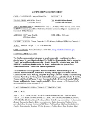
ZONING CHANGE REVIEW SHEET 6520 Lynch Lane SITE AREA: 4.31 acres DISTRICT: 3 TO: CS-MU-NP for Tract 1 LR-MU-NP for Tract 2 CASE: C14-2022-0107 – Vargas Mixed Use ZONING FROM: GR-NP for Tract 1 LR-NP for Tract 2 AMENDED REQUEST: CS-DB90-NP for Tract 1; LR-DB90-NP for Tract 2, and to waive the DB90 ordinance ground floor Pedestrian-Oriented Commercial Spaces requirement per Section 25-2-652 (F)(3)(e) ADDRESS: 400 Vargas Road & PROPERTY OWNER: Vargas Properties I LTD & Jayco Holdings I LTD (Jay Chernosky) AGENT: Thrower Design, LLC (A. Ron Thrower) CASE MANAGER: Nancy Estrada (512-974-7617, nancy.estrada@austintexas.gov) STAFF RECOMMENDATION: The Staff recommendation is to grant general commercial – conditional overlay – density bonus 90 – neighborhood plan (CS-CO-DB90-NP) combining district zoning for Tract 1 and neighborhood commercial – density bonus 90 – neighborhood plan (LR- DB90-NP) combining district zoning for Tract 2 and to waive the ground floor Pedestrian-Oriented Commercial Spaces requirement. The Conditional Overlay prohibits Automotive Rentals, Automotive Repairs & Services, Automotive Sales, Automotive Washing (of any type), Bail Bond Services, Commercial Off-Street Parking, Drop-Off Recycling Collection Facility, Exterminating Services, Pawn Shop Services, Adult Oriented Businesses, Agricultural Sales & Service, Commercial Blood & Plasma Center, Construction Sales & Service, Kennels, Vehicle Storage and limits the Impervious Cover to 80%. For a summary of the basis of Staff’s recommendation, please see pages 3 - 5. PLANNING COMMISSION ACTION / RECOMMENDATION: June 11, 2023: April 11, 2023: APPROVED CS-MU-CO-NP COMBINED DISTRICT ZONING FOR TRACT 1, with ADDED CONDITIONS and LR-MU-NP COMBINED DISTRICT ZONING FOR TRACT 2. The Conditional Overlay prohibits the following uses on Tract 1: Automotive Rentals, Automotive Repairs & Services, Automotive Sales, Automotive Washing (of any type), Bail Bond Services, Commercial Off-Street Parking, Drop-Off Recycling Collection Facility, Exterminating Services, Off-Site Accessory Parking, Pawn Shop Services, Adult C14-2022-0107 Oriented Businesses, Agricultural Sales & Service, Commercial Blood & Plasma Center, Construction Sales & Service, Kennels, Vehicle Storage and limits the Impervious Cover to 80%. Page 2 [G. COX; J. MUSHTALER – 2ND] (12-0) Y. FLORES – ABSENT March 28, 2023: Approved a postponement request by the neighborhood to April 11, 2023 [J. Thompson; C. Hempel – 2nd] (13-0) G. Anderson – Nay on Item 34 March 14, 2023: Approved a staff postponement request to March 28, 2023 [R. Schneider; C. Hempel – 2nd] (9-0) Y. Flores, J. Mushtaler, J. Shieh, and J. Thompson – Absent February 28, 2023: Approved a staff postponement request to March 14, 2023 [R. Schneider; P. Howard – 2nd] (11-0) Y. Flores – Absent; One vacancy on the dais January 24, 2023: Approved a staff postponement request to February 28, 2023 [C. Hempel; J. Shieh – 2nd] (10-0) A. Azhar, R. Schneider – Absent; One vacancy on the dais CITY COUNCIL ACTION: April 4, 2024: APPROVED AN INDEFINITE POSTPONEMENT REQUEST BY THE APPLICANT VOTE: 10-0. Council Member A. Alter was off the dais. February 29, 2024: APPROVED A POSTPONEMENT REQUEST BY THE APPLICANT TO APRIL 4, 2024. VOTE: 11-0. VOTE: 11-0. January 18, 2024: APPROVED A POSTPONEMENT REQUEST BY THE APPLICANT TO FEBRUARY 29, 2024. November 30, 2023: APPROVED A POSTPONEMENT REQUEST BY THE APPLICANT TO JANUARY 18, 2024. VOTE: 10-0. Council Member R. Alter was absent. October 19, 2023: SECOND READING APPROVED AS PLANNING COMMISSION RECOMMENDED. VOTE: 10-0. Council Member Harper-Madison was absent. September 14, 2023: FIRST READING APPROVED AS PLANNING COMMISSION RECOMMENDED. VOTE: 7-0. Mayor Pro Tem Ellis, Council Members Harper-Madison, A. Alter, and Pool off the dais. C14-2022-0107 July 20, 2023: APPROVED A POSTPONEMENT REQUEST BY THE APPLICANT TO SEPTEMBER 14, 2023. Page 3 VOTE: 10-0. Council Member Fuentes was off the dais. ORDINANCE NUMBER: ISSUES: On April 11, 2023, the Planning Commission made the recommendation of (CS-MU-CO- NP) with added conditions for Tract 1 and (LR-MU-NP) combining district zoning for Tract 2 of the subject property. The applicant requested an Indefinite Postponement at City Council on April 4, 2024. Subsequently, the applicant has amended their rezoning application to request the new (DB90) combining district and to waive the (DB90) ordinance ground floor Pedestrian-Oriented Commercial Spaces requirement per Section 25-2-652 (F)(3)(e). Please see Attachment A. Currently the newly created density bonus 90 (DB90) combining district ordinance requires that when a site abuts a principal street, 75 percent of the ground floor of the building must contain one or more commercial uses. However, the ordinance allows for modifying this requirement if the site abuts an urban roadway, suburban roadway, highway, or hill country roadway. The subject property abuts both a highway and two urban roadways, both of which are eligible roadways to request this modification. The site has frontage on US Hwy 183 which is a high traffic and high speed highway. There are not any traffic lights or pedestrian oriented uses along this section of frontage road. The property is also adjacent to Vargas Road and Saxon Lane which are both surrounded by single family residences. Vargas Road connects to US Hwy 183 while Saxon Road is a low traffic residential collector that is a dead end street. This site is not located in an area that has existing ground floor assets or enough household density to support the amount of ground floor commercial required by the code. Further, this site is not within a geographic area where the City is actively promoting or enhancing small business development. Therefore, Staff recommends granting the applicant’s modification request to not require pedestrian-oriented commercial space. CASE MANAGER COMMENTS: The subject undeveloped and un-platted tracts are located west of US-Hwy 183, between Vargas Road and Saxon Lane. The property is two tracts that total 4.31 acres. The larger Tract 1 is 3.76 acres with frontage along US Hwy 183 and is north of Vargas Road and south of Saxon Lane. The smaller Tract 2 is 0.55 acres and is located north of the intersection at Vargas Road and Lynch Lane. Tract 1 fronts both Vargas Road and Saxon Lane and is zoned GR-NP. Tract 2 fronts Vargas Road and Lynch Lane and is zoned LR-NP. Both tracts are located within the Montopolis Neighborhood Planning Area. Page 4 C14-2022-0107 There are some commercial uses to the north (GR-NP); however, single family residences surround both tracts to the north, west and south (SF-3-NP); townhouse / condominium residences and neighborhood commercial are also to the west across Saxon Lane (SF-6-NP; LR-NP). Directly to the east across Vargas Road are a neighborhood park and a learning center (SF-3-NP). An elementary school and pre-school are also in the area. Please refer to Exhibits A (Zoning Map) and A-1 (Aerial). The applicant has amended their request to (CS-DB90-NP) for the larger Tract 1 and to (LR-DB90-NP) for Tract 2. Future access is proposed for both Vargas Road and Saxon Lane. Currently there is not a proposed conceptual plan. Staff is recommending (CS-CO-DB90-NP) for Tract 1 with a Conditional Overlay that consists of prohibited uses listed above and (LR-DB90-NP) for Tract 2. When Planning Commission previously made their recommendation, this Conditional Overlay was included. The Applicant is in agreement with the Conditional Overlay that has been incorporated in the Staff recommendation. BASIS OF RECOMMENDATION: 1. The proposed zoning should be consistent with the purpose statement of the district sought. The proposed general commercial services (CS) district zoning is intended for commercial or industrial uses that typically have operating characteristics or traffic service requirements generally incompatible with residential environments. The neighborhood commercial (LR) district is intended for providing business services and office facilities for the residents of a neighborhood. The Conditional Overlay (CO) combining district may be applied in combination with any base district. The district is intended to provide flexible and adaptable use or site development regulations by requiring standards tailored to individual properties. The staff recommends prohibiting the more intensive commercial uses such as Automotive, Bail Bond Services, Commercial Off-Street Parking, Drop-Off Recycling Collection Facility, Exterminating Services, Pawn Shop Services, Adult Oriented Businesses, Agricultural Sales & Services, Commercial Blood & Plasma Center, Construction Sales & Services, Kennels, and Vehicle Storage on this property as these uses are not compatible with residential uses or near a public school. The Density Bonus 90 (DB90) combining district, in exchange for providing affordable housing units and in combination with commercial base zoning districts, allows a mixture of office, retail, commercial, and residential uses with modifications of compatibility standards and site development regulations including increased building height. The neighborhood plan (NP) district denotes a tract located within the boundaries of an adopted Neighborhood Plan. Page 5 Zoning changes should promote compatibility with adjacent and nearby uses. C14-2022-0107 2. Staff recommends CS-CO-DB90-NP and LR-DB90-NP zoning given its access to an arterial street, US-Hwy 183, and collector streets, Vargas Road and Saxon Lane, as well as its adjacency to residential, multifamily, and civic properties. 3. The proposed CS-CO-DB90-NP and LR-DB90-NP zoning will permit the applicant to redevelop the property for future residential use. Although a modification to the required ground floor commercial space is being requested, office, civic and low intensity commercial uses and services can still be provided to the surrounding community. EXISTING ZONING AND LAND USES: The proposed zoning should allow for a reasonable use of the property. ZONING Site GR-NP; LR-NP North GR-NP; SF-3-NP South East West SF-3-NP; SF-4A-NP SF-3-NP; CS-NP; CS-MU-CO-NP; LR- MU-CO-NP LR-NP; SF-3-NP; SF-6-NP LAND USES Undeveloped Single family residences; Religious assembly; US-183 Hwy Single family residences; Elementary school Civitan Neighborhood Park; Pre-school; Multi-family Single family residences Martin Middle School SCENIC ROADWAY: No NEIGHBORHOOD PLANNING AREA: Montopolis WATERSHED: Country Club East Creek – Suburban; Colorado River Creek - Urban CAPITOL VIEW CORRIDOR: No SCHOOLS: Allison Elementary School COMMUNITY REGISTRY LIST: Austin Neighborhoods Council SEL Texas Preservation Austin Friends of Austin Neighborhoods Carson Ridge Neighborhood Association Crossing Gardenhome Owners Assn. (The) Del Valle Community Coalition Montopolis Community Alliance Montopolis Tributary Trail Association Vargas Neighborhood Association East Austin Conservancy Montopolis Neighborhood Association Pleasant Valley Neighborhood Empowerment Foundation Austin Independent School District Sierra Group, Austin Regional Group Austin Lost and Found Pets Homeless Neighborhood Association Eastside Memorial High School NUMBER C14-2020-0044 – Saxon Acres Residential Zoning – 316 Saxon Ln & 6328 El Mirando St. C14-2014-0176 – Cuellar Rezoning – 617 Thrasher Ln C14-2022-0107 Montopolis Neighborhood Association Plan Contact Team (MNPCT) Montopolis-Ponca Neighborhood Association Montopolis Community Development Corporation El Concilio Mexican-American Neighborhoods AREA CASE HISTORIES: Page 6 REQUEST COMMISSION CITY COUNCIL SF-3-NP to SF-6-NP To Grant SF-6-NP Apvd SF-6-NP as Commission recommended (12-10-2020). Apvd SF-4A-NP (4-16-2015). SF-3-NP to SF-4A-NP To Grant SF-4A-CO- NP, w/CO limiting the floor-to-area ratio to 0.4:1 RELATED CASES: NPA-2022-0005.01 The Montopolis Neighborhood Plan Area was adopted on September 27, 2001 (NP-05-0020; C14-05-0105 – Ordinance No. 010927-05) ADDITIONAL STAFF COMMENTS: Drainage The developer is required to submit a pre- and post-development drainage analysis at the subdivision and site plan stage of the development process. The City’s Land Development Code and Drainage Criteria Manual require that the Applicant demonstrate through engineering analysis that the proposed development will have no identifiable adverse impact on surrounding properties. Environmental The site is not located over the Edwards Aquifer Recharge Zone. The site is in the Country Club East Creek Watershed classified as a Suburban Watershed and Colorado River Creek Watershed of the Colorado River Basin classified as an Urban Watershed by Chapter 25-8 of the City's Land Development Code. The site is in the Desired Development Zone. C14-2022-0107 Under current watershed regulations, development or redevelopment on this site within the suburban watershed will be subject to the following impervious cover limits: Page 7 Development Classification % of Gross Site Area % of Gross Site Area Single-Family (minimum lot size 5750 sq. ft.) Other Single-Family or Duplex Multifamily Commercial 50% 55% 60% 80% with Transfers 60% 60% 70% 90% Zoning district impervious cover limits apply in the Urban Watershed classification. According to floodplain maps there is no floodplain within or adjacent to the project location. Standard landscaping and tree protection will be required in accordance with LDC 25-2 and 25-8 for all development and/or redevelopment. At this time, site specific information is unavailable regarding vegetation, areas of steep slope, or other environmental features such as bluffs, springs, canyon rimrock, caves, sinkholes, and wetlands. Under current watershed regulations, development or redevelopment requires water quality control with increased capture volume and control of the 2-year storm on site. At this time, no information has been provided as to whether this property has any preexisting approvals that preempt current water quality or Code requirements. PARD – Planning & Design Review Parkland dedication will be required at the time of subdivision or site plan application for new residential units, per City Code § 25-1-601, as amended. The proposed development meets the criteria for land dedication in City Code Title 25, Article 14. As such, a partial land dedication may be required, as well as any remaining fees in-lieu. The Parks and Recreation Department (PARD) would consider a connection to Civitan Neighborhood Park from Saxon Lane and possibly El Mirando Street toward satisfying the requirement at time of permitting (whether subdivision or site plan). Such a connection would improve neighborhood connectivity to parkland, a criterion for dedication per City Code Title 25, Article 14. Should there be any remaining fees in-lieu, those fees shall be used toward park investments in the form of land acquisition and/or park amenities within the surrounding area, per the Parkland Dedication Operating Procedures § 14.3.11 and City Code § 25-1-607 (B)(1) & (2). C14-2022-0107 Should the applicant wish to discuss parkland dedication requirements in advance of site plan or subdivision applications, please contact this reviewer: thomas.rowlinson@austintexas.gov. At the applicant’s request, PARD can provide an early determination letter of the requirements as stated in this review. Site Plan and Compatibility Standards Page 8 Site plans will be required for any new development other than single-family, two-family or duplex residential. Any development which occurs in an SF-6 or less restrictive zoning district which is located 540-feet or less from property in an SF-5 or more restrictive zoning district will be subject to compatibility development regulations. The site is subject to compatibility standards due to the adjacent SF-3 district to the west. Any new development is subject to Subchapter E. Design Standards and Mixed Use. Additional comments will be made when the site plan is submitted. Airport Overlay The site is located within Austin-Bergstrom Overlay {Controlled Compatible Land Use Area}. No use will be allowed that creates electrical interference with navigational signals or radio communications between airport and aircraft, makes it difficult for pilots to distinguish between the airport lights and others, results in glare in the eyes of pilots using the airport, impairs visibility in the vicinity of the airport, creates bird strike hazards or otherwise in any way endanger or interfere with the landing, taking off, or maneuvering of aircrafts intending to use the Austin-Bergstrom Airport. Height limitations and incompatible uses with each Airport Overlay zone are established in the Airport Overlay Ordinance. Airport Hazard Zoning Committee review may be required prior to Planning Commission Hearing. ATD Engineering Review ASMP Assessment The Austin Strategic Mobility Plan (ASMP) calls for 72 feet of right-of-way for Vargas Road. It is recommended that 36 feet of right-of-way from the existing centerline should be dedicated for Vargas Road according to the Transportation Plan with the first subdivision or site plan application. [LDC 25-6-51 and 25-6-55]. The Austin Strategic Mobility Plan (ASMP) calls for 64 feet of right-of-way for Saxon Lane. It is recommended that 32 feet of right-of-way from the existing centerline should be dedicated for Saxon Lane according to the Transportation Plan with the first subdivision or site plan application. [LDC 25-6-51 and 25-6-55]. Page 9 Capital Metro (within ¼ mile) Yes Yes C14-2022-0107 The adjacent street characteristics table is provided below: Name ASMP Classification Existing ROW Existing Pavement Sidewalks Bicycle Route ASMP Required ROW Vargas Road Level 2 – Collector Saxon Lane Level 1 – Residential Collector 72’ 64’ 54’ 39’ Yes N/A 56’ 30’ No Wide Curb Lane Transportation Assessment A TIA is not required. A Neighborhood Traffic Analysis is required and will be performed for this project by ATD staff. Results will be provided in a separate memo. [LDC 25-6-114]. Please see Attachment D. Austin Water Utility The landowner intends to serve the site with City of Austin water and wastewater utilities. The landowner, at own expense, will be responsible for providing any water and wastewater utility improvements, offsite main extensions, utility relocations and or abandonments required by the land use. The water and wastewater utility plan must be reviewed and approved by Austin Water for compliance with City criteria and suitability for operation and maintenance. Based on current public infrastructure configurations, it appears that service extension requests (SER) will be required to provide service to this lot. For more information pertaining to the Service Extension Request process and submittal requirements contact the Austin Water SER team at ser@austintexas.gov. The landowner must pay the City inspection fee with the utility construction. The landowner must pay the tap and impact fee once the landowner makes an application for a City of Austin water and wastewater utility tap permit. Page 10 C14-2022-0107 INDEX OF EXHIBITS AND ATTACHMENTS TO FOLLOW: Exhibit A: Zoning Map Exhibits A-1: Aerial Maps (2) Exhibit B: Zoning Application Map Attachment A: Applicant’s (DB90) Commercial Modification Request Letter Attachment B: Applicant’s Indefinite Postponement and Amendment Request Letter Attachment C: Applicant’s Summary Letter Attachment D: Neighborhood Traffic Analysis (NTA) Correspondence EXHIBIT A !!!!!!!!!!!!!!!!!!!!!!!!!!!!!!!!!!!!!!!!!!!!!!!!!!!!!!!!!!!!!!!!!!!!!!!!!!!!!!!!!!!!!!!!!!!!!!!!!!!!!!!!!!!!!!!!!!(!(!(!(!(!(!(!(!(!(!(!(!(!(!(!(!(!(!(!(!(!(!(!(!(!(!(!(!(!(!(!(!(!(!(!(!(!(!(!(!(!(!(!(!(!(!(!(!(!(!(!(!(!(!(!(!(!(!(!(!(!(!(!(!(!(!(!(!(!(!(!(!(!(!(!(!(!(!(!(!(!(!(!(!(!(!(!(!(!(!(!(!(!(!(!(!(!(!(!(!(!(!(!(!(!(!(!(!(!(!(!(!(!(!(!(!(!(!(!(!(!(!(!(!(!(!(!(!(!(!(!(!(!(!(!(!(!(!(!(!(!(!(!(!(!(!(!(!(!(!(!(!(!(!(!(!(!(!(!(!(!(!(C14-00-2004C14-2015-0104NPA-2015-0005.04C14-2010-0138NPA-2010-0005.03NPA-2015-0005.04NPA-2015-0005.04NPA-2015-0005.04C14-2020-0044C14-04-0175NPA-2015-0005.04NPA-2016-0005.04NPA-2015-0005.04C14-2019-0013C14-2011-0096C14-2014-0176C14-2014-0124C14-04-0084NPA-2012-0005.02C14-97-0063VARGASRDBASTROPHWYSBBASTROPHWYNBPONCASTKEMPSTMONTOPOLISDRTHRASHERLNSAXONLNLYNCHLNDELMONTERDHERGOTZ LNELMIRANDOSTTORRESSTVALDEZSTFELIXAVEBASTROPHWYSVRDSBCLOVISSTCRUMLEYLNTHOMPSONLNMONSANTODRBONNETTSTKIMBLELNWALKERLNRICHARDSONLNVERALNGROVEDRCSRRSF-3DRCS-NPSF-3-NPSF-3-NPSF-3-NPSF-3-NPP-NPSF-3-NPSF-3-NPCSSF-3-NPLISF-3-NPGO-MU-CO-NPGR-NPSF-3-NPSF-2CS-CO-NPGR-NPSF-3-NPCS-COSF-6-NPSF-3CS-MU-CO-NPGR-NPMHMF-2-CO-NPLR-NPSF-3-NPCS-NPGR-CO-NPMF-2-NPLR-MU-CO-NPSF-3-NPLO-NPSF-3-NPMF-2-NPSF-3-NPCS-NPGR-NPSF-3GR-NPSF-3-NPMF-1-COLR-MU-NPI-SF-2SF-3-NPLIGR-NPCS-1-COSF-4A-NPCS-NPSF-4A-CO-NPGR-MU-NPGR-NPCS-NPLR-MU-NPUNDEV85-286R.C.95-5582-8672-9478-13177-18485-16188-8704-017501-006000-2004SP-03-0527DREP.SHP.CP74-34CIVITAN PARKINSPEC.84-89RCSP91-104CAUTO\SALES/\REPAIRBABERSHP.BOY'SCLUBTRAILERPARKTELEPHONECOTRAILERVACANT BLDG.VECH.VAC\BLDGVACANT CHURCH BLDG.UPHOLS.FARM\SUPPLYWASHATERIASUPPLY COMPANYBARBERSHOPELEMENTARY SCHOOLVAC. BLDG.UNDEVELOPEDGASCHURCHCONV. STORECARWASH01-006000-200401-006001-006001-006001-006001-006001-006001-006000-200401-006001-006001-006001-006001-006001-006001-006000-2004VACANT BLDG.ZONING±This product is for informational purposes and may not have been prepared for or be suitable for legal,engineering, or surveying purposes. It does not represent an on-the-ground survey and represents only theapproximate relative location of property boundaries.This product has been produced by the Housing and Planning Department for the sole purpose of geographicreference. No warranty is made by the City of Austin regarding specific accuracy or completeness.ZONING CASE#:C14-2022-0107SUBJECT TRACT!!!!!!PENDING CASEZONING BOUNDARYTRACT 2Created: 8/16/20220400200FeetTRACT 1 EXHIBIT A-1 !!!!!!!!!!!!!!!!!!!!!!!!!!!!!!!!!!!!!!!!!!!!!!!!!!!!!!!!!!!!!!!!!!!!!!!!!!!!!!!!!!!!!!!!!!!!!!!(!(!(!(!(!(!(!(!(!(!(!(!(!(!(!(!(!(!(!(!(!(!(!(!(!(!(!(!(!(!(!(!(!(!(!(!(!(!(!(!(!(!(!(!(!(!(!(!(!(!(!(!(!(!(!(!(!(!(!(!(!(!(!(!(!(!(!(!(!(!(!(!(!(!(!(!(!(!(!(!(!(!(!(!(!(!(!(!(!(!(!(!(!(!(!(!(!(!(!(!(!(!(!(!(!(!(!(!(!(!(!(!(!(!(!(!(!(!(!(!(!(!(!(!(!(!(!(!(!(!(!(!(!(!(!(!(!(!(!(!(!(!(!(!(!(!(!(!(!(!(!(!(!(!(!(!(!(!(!(!(!(!(L20L19M20M19C14-2022-0107C14-00-2004C14-2015-0104NPA-2015-0005.04C14-2010-0138NPA-2010-0005.03NPA-2015-0005.04NPA-2015-0005.04NPA-2015-0005.04C14-2020-0044C14-04-0175NPA-2015-0005.04NPA-2016-0005.04NPA-2015-0005.04C14-2019-0013C14-2011-0096C14-2014-0176C14-2014-0124C14-2022-0211C14-04-0084NPA-2012-0005.02C14-97-0063VARGASRDBASTROPHWYSBBASTROPHWYNBPONCASTKEMPSTMONTOPOLISDRTHRASHERLNSAXONLNLYNCHLNDELMONTERDHERGOTZ LNELMIRANDOSTTORRESSTVALDEZSTFELIXAVEBASTROPHWYSVRDSBCLOVISSTCRUMLEYLNTHOMPSONLNMONSANTODRBONNETTSTKIMBLELNWALKERLNRICHARDSONLNVERALNGROVEDRCSRRSF-3DRCS-NPSF-3-NPSF-3-NPLR-NPSF-3-NPSF-3-NPP-NPSF-3-NPCSSF-3-NPLISF-3-NPGO-MU-CO-NPGR-NPSF-3-NPSF-2CS-CO-NPGR-NPSF-3-NPCS-COSF-6-NPSF-3CS-MU-CO-NPGR-NPMHMF-2-CO-NPSF-3-NPCS-NPGR-CO-NPMF-2-NPLR-MU-CO-NPLO-NPSF-3-NPMF-2-NPSF-3-NPCS-NPGR-NPSF-3GR-NPSF-3-NPSF-3-NPMF-1-COLR-MU-NPI-SF-2SF-3-NPLIGR-NPCS-1-COSF-4A-NPCS-NPSF-4A-CO-NPGR-MU-NPGR-NPCS-NPLR-MU-NPVargas Mixed Use±This product has been produced by the Housing and Planning Department for the sole purpose of geographicreference. No warranty is made by the City of Austin regarding specific accuracy or completeness.ZONING CASE#:LOCATION:SUBJECT AREA:GRID:MANAGER:C14-2022-0107400 Vargas Rd; 6520 Lynch Ln4.3 AcresL19, L20Nancy EstradaCreated: 3/14/2023SUBJECT TRACTZONING BOUNDARY!!!!!!PENDING CASECREEK BUFFER0200400600800100Feet SF-3 RR C14-00-2004 B A P H S T R W Y O N P B CS B A S T R O H W Y S B M20 ( N LN R E P. SAXO ! ! ! ! ! ! ! ! ! ! ! ! 01-0060 ! ! ! ! ! !! ! ( 82-86 01-0060 SF-3-NP C R ( U M L E ( Y L N ( ( ( ( ( ( ( ( ( ( ( ( ( CS-NP SF-3-NP TH R AS H E R LN ( ( ( ( ( H C R U H C E L M ( I R A N D O S T 01-0060 ( ( ( ( ( ( L Y N C ( ( H L N ( ( ( ( ( ( ( ( ( ( BARBER SH O P ( ( ( T O R R E ( ( ( SF-3-NP S S T ( 01-0060 SF-6-NP C14-2020-0044 GR-NP T T S ( T E N N ( O B D E L M ( GR-NP ( O N T ( E R D ( ( L20 ! ! ! ! ( ( ! ! ! ! ! ! ! ! ! ! ! ! ! ! ! ! ! ! ! ! ! ! ! 01-0060 ! ! ! ! ! ! ! ! ! ! ! ! ! ! ! ! ! ! ! ! ! ! ! ! ! ! ! ! ! ! ! ! ! ! ! ! LR-NP ! ! ! ! ! ! ! ! ! ( ! ! ! ! ! ! ! ! ! ( ( SF-3-NP SF-3-NP L19 CIVITAN PARK ( ! ! ! ! GR-NP C14-2022-0107 ! ! ! ! D S R ! ! A G ! ! A V R H . E P C S C . E V I N T R A I L E R 01-0060 CS-NP M19 NPA-2015-0005.04 CS-CO-NP CS-MU-CO-NP NPA-2015-0005.04 NPA-2015-0005.04 C14-2015-0104 NPA-2015-0005.04 LR-MU-CO-NP SP-03-0527D 77-184 ± 1 " = 200 ' Vargas Mixed Use EXHIBIT A-1 SUBJECT TRACT ZONING BOUNDARY ! ! ! ! ! ! PENDING CASE CREEK BUFFER ZONING CASE#: LOCATION: SUBJECT AREA: GRID: MANAGER: C14-2022-0107 400 Vargas Rd & 6520 Lynch Ln 4.30 Acres L19, L20 Nancy Estrada This product has been produced by the Housing and Planning Department for the sole purpose of geographic reference. No warranty is made by the City of Austin regarding specific accuracy or completeness. Created: 9/1/2022 by: MeeksS EXHIBIT B CS-MU-CO-NPCS-NPSF-3-NPCS-COCSLR-NPCSCS-NPSF-3-NPSF-3-NPGR-NPRRSF-2GR-NPSF-3-NPSF-3-NPSF-3-NPCS-CO-NPLR-MU-CO-NPMF-2-NPSF-4A-CO-NPMF-2-NPCS-NPGR-NPLO-NPSF-4A-NPSF-3-NPSAXON LNMONTOPOLISDRTHRASHERLNCRUMLEY LNMONSANTODRDEL MONTERDBASTROP HWYNBBASTROP HWYSBVARGAS RDEL MIRANDOSTLYNCH LNTORRES ST¯00.150.30.07MilesZoning BoundaryMobile Home ResidenceCommercialOfficeIndustrialCBD; Downtown Mixed UseSpecial DistrictsAgriculture; Development ReserveAviation; Unzoned; PublicMultifamily ResidencePlanned Unit DevelopmentLake Austin Residential; Residential Low DensitySingle Family ResidenceUnclassifiedSubject Properties¯Vargas Mixed Use - 400 Vargas Rd. & 6520 Lynch LaneZoning ApplicationJuly 26, 2022 ATTACHMENT A June 6, 2024 Ms. Lauren Middleton-Pratt, Director Planning Department City of Austin 1000 E. 11th Street Austin, Texas 78702 RE: C14-2022-0107 - Vargas Mixed Use Rezoning – DB90 Commercial Waiver Dear Ms. Middleton-Pratt, We respectfully request consideration to waive the requirements for ground floor commercial uses with this rezoning of the subject property. While the granting of this waiver does not eliminate potential ground floor commercial use, a granting of this waiver will provide the most flexibility to accommodate any recognized demand for commercial space at the time of development. Pursuant to Section 25-2-652(F)(3)(2), the City is authorized to waive ground floor commercial requirements with the rezoning to include the DB90 Overlay along roadways that are designated as (i) Urban Roadway and (iii) Highway. The subject property has frontage on three roadways / classifications – US 183 Frontage Road – Highway Saxon Lane – Urban Roadway Vargas Road – Urban Roadway Taking these roadways individually for the context along the roadway type with the area development and the justifications for the waiver request, we provide as follows: US 183 Frontage Road – This is a mile-long, high-traffic, high-speed roadway with this section connecting Montopolis Drive with the Toll Road of US 183 / SH 71 / Ben White Blvd. There are not any traffic lights along this segment of frontage road and the only through street connecting US 183 to E. Riverside Drive is Vargas Road (which abuts the subject property). The US 183 Frontage Road does not have any pedestrian oriented uses today and the only commercial uses P . O . B O X 4 1 9 5 7 , A U S T I N , T E X A S 7 8 7 0 4 1 5 0 7 I N G L E W O O D S T . , A U S T I N , T E X A S 7 8 7 4 1 found along the roadway today are a small roofing company, a large self-storage, and a contractor yard. Other uses include apartments, a church, a school, a small day care, and a park. US 183 is a recent roadway redeveloped in Austin and was not planned well for future growth with assumptions for mixed-use development. Important to note is that no commercial uses are found at the intersection of Montopolis and US 183. This is a very busy intersection and is the prime node for commercial space and the market is clearly not demanding commercial space for this intersection at this time. Our position is that this roadway ‘could’ support commercial uses in the future, but a requirement for ground-floor, pedestrian oriented uses are not conducive along a roadway that is high-traffic and high-speed with little connectivity. Therefore, we respectfully request consideration to not mandate ground-floor pedestrian oriented commercial space with this rezoning and allow for the building to organically include those uses at the time of development should the area find demand for such uses. Saxon Lane – This very low traffic road is a dead-end street with only single-family homes today, though a small-yield multifamily development is planned across the street from the subject property. There are two roadways, Del Monte Street and Torres Street, that connect Saxon Lane to Montopolis Road, and both are narrow roadways with single-family homes. Torres Street has two sharp bends in the middle of the roadway segment that eliminate all visibility from Montopolis Drive. Del Monte Street intersects Saxon Lane very close to the intersection with US 183 due to the state acquisition of land creating a substandard traffic condition.