28 C14-2024-0018 - 2323 Town Lake Circle; District 3 — original pdf
Backup
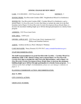
ZONING CHANGE REVIEW SHEET DISTRICT: 3 CASE: C14-2024-0018 – 2323 Town Lake Circle ZONING FROM: East Riverside Corridor (ERC- Neighborhood Mixed Use Subdistrict) ZONING TO: East Riverside Corridor (ERC- Corridor Mixed Use Subdistrict), and to amend Figure 1-6 (East Riverside Corridor Hub Map) to include the entire lot in the Hub boundary and to Figure 1-8 (East Riverside Corridor Development Bonus Height Map), to increase the maximum building height up to 160 feet through participation in a density bonus program ADDRESS: 2323 Town Lake Circle SITE AREA: 1.0439 acres OWNER / APPLICANT: 2323 Town Lake Circle Apartments LLC (Robyn and Jonathan Ganacas) AGENT: Armbrust & Brown, PLLC (Michael J. Whellan) CASE MANAGER: Nancy Estrada (512-974-7617, nancy.estrada@austintexas.gov) STAFF RECOMMENDATION: The Staff recommendation is to grant East Riverside Corridor – Corridor Mixed Use Subdistrict (ERC-CMU) district zoning, and to amend Figure 1-6 (East Riverside Corridor Hub Map) to include the entire lot in the Hub boundary, and to Figure 1-8 (East Riverside Corridor Development Bonus Height Map), to increase the maximum building height up to 160 feet through participation in a density bonus program. For a summary of the basis of Staff’s recommendation, please see case manager comments on pages 2 - 3. PLANNING COMMISSION ACTION / RECOMMENDATION: June 11, 2024: CITY COUNCIL ACTION: ORDINANCE NUMBER: C14-2024-0018 Page 2 ISSUES: The developer will comply with the Tenant Notification and Relocation Assistance requirements in the City of Austin Land Development Code. [LDC 25-1-712]. The owner has offered a private Restrictive Covenant to provide additional benefits to those who are entitled to notification under the Tenant Relocation provisions of Section 25-1-712 for the existing buildings. CASE MANAGER COMMENTS: The subject rezoning area is approximately 1.04 acres located north of East Riverside Drive on Town Lake Circle. The property is currently developed with a 3-story building of existing multifamily residences with 42 units. This site is in the East Riverside Corridor (ERC) Regulating Plan within the Neighborhood Mixed Use (NMU) subdistrict and is not located within the hub boundary. All the properties along Town Lake Circle were originally rezoned to the East Riverside Corridor (ERC) Neighborhood Mixed Use (NMU) subdistrict. Since 2016, eleven properties along Town Lake Circle and the adjacent Elmont Drive have been rezoned to the Corridor Mixed Use (CMU) subdistrict. The subject property located at 2323 Town Lake Circle is the one remaining parcel in this area that is still zoned as ERC-NMU. Directly to the north are properties along Town Lake Circle that are undeveloped (ERC- CMU); multifamily residences are to the west and east along Town Lake Circle (ERC- CMU); a storage facility is immediately to the south as well as commercial and restaurant uses that are along East Riverside Drive (ERC-NMU; ERC-CMU). Please refer to Exhibits A (Zoning Map) and A-1 (Aerial Exhibit). East Riverside Drive is designated as a core transit corridor. Town Lake Circle, from which access is proposed for the future development, is an urban roadway that intersects with Elmont Drive at two locations. There are two Capital Metro bus stops and routes along Elmont Drive that are located within one quarter of a mile north of the property. The (NMU) subdistrict allows for buildings up to 50 feet in height; however, since the property is not within the hub boundary, it is ineligible for a development bonus. The Applicant is requesting to rezone the property to the Corridor Mixed Use (ERC-CMU) subdistrict, to amend Figure 1-6 (East Riverside Corridor Hub Map) to include the entire property in the Hub boundary, and to Figure 1-8 (East Riverside Corridor Development Bonus Height Map), to increase the maximum building height up to 160 feet through participation in a density bonus program. Please refer to attached Figures. The requested amendment would allow the property to be redeveloped with 200 multifamily residences at a maximum building height up to 160 feet. The additional height and density would be in exchange for the provision of community benefits. C14-2024-0018 Page 3 The proposed zoning should be consistent with the goals and objectives of the Staff is recommending the Corridor Mixed Use subdistrict (ERC-CMU), to include the entire lot in the hub boundary, and to increase the maximum building height up to 160 feet through participation in a density bonus program. BASIS OF RECOMMENDATION: 1. City Council. The East Riverside Corridor Regulating Plan created land use districts to help guide development in accordance with proposed transit improvements. The proposed transit improvements, now known as Project Connect’s Blue Line Project, maintain the same general alignment and transit center alignment as shown in the ERC Regulating Plan. The Pleasant Valley MetroRapid line is also a part of the Project Connect plan. This line proposes service from northeast to southeast Austin with one of the stations being at the intersection of East Riverside Drive and South Pleasant Valley Road. This site is located just north of East Riverside Drive which is identified as a Core Transit Corridor within the ERC. The current CapMetro bus system shows approximately two existing MetroBus stops and routes on Elmont Drive which are less than one quarter of a mile from the property. There are also other regular routes along East Riverside Drive. The Corridor Mixed Use (CMU) subdistrict is the highest intensity district as it relates to density and height. Rezoning this lot to the (CMU) subdistrict and allowing inclusion within the Hub boundary would promote higher density and supports transit development. Based on the information above, Staff believes the proposed rezoning change is supported by the East Riverside Corridor Regulating Plan. EXISTING ZONING AND LAND USES: ZONING Site North ERC (CMU subdistrict); ERC (NMU subdistrict) Multifamily residences (42 units) Undeveloped; Oracle campus LAND USES PUD-NP South ERC (NMU & CMU subdistricts) ERC (CMU subdistrict) Multifamily residences ERC (CMU subdistrict) Multifamily residences East West Storage Warehouse; Commercial uses; Restaurants NEIGHBORHOOD PLANNING AREA: East Riverside/Oltorf Combined (Riverside) WATERSHED: Lady Bird Lake – Urban CAPITOL VIEW CORRIDOR: No SCENIC ROADWAY: No C14-2024-0018 Page 4 Eastside Memorial High School Friends of Austin Neighborhoods, East Austin Conservancy, Pleasant Valley, Preservation Austin, SELTexas, Sierra Club Austin Regional Group, Martin Middle School SCHOOLS: Austin Independent School District Sanchez Elementary School COMMUNITY REGISTRY LIST: Austin Independent School District, Austin Lost and Found Pets, Austin Neighborhoods Council, Crossing Gardenhome Owners Assn. (The), Del Valle Community Coalition, East Riverside Corridor Staff Liaison, Homeless Neighborhood Association, Friends of Riverside ATX Neighborhood Association, Neighborhood Empowerment Foundation, Southeast Austin Neighborhood Alliance, East Riverside/Oltorf Neighborhood Plan Contact Team Waterfront Condominium Homeowners Association AREA CASE HISTORIES: NUMBER C14-2022-0001 REQUEST ERC-NMU to ERC-CMU COMMISSION To Grant ERC-CMU (09/27/2022) C14-2021-0014 ERC-NMU to ERC-CMU To Grant ERC-CMU (04/13/2021) C14-2018-0065 ERC-NMU to ERC-CMU To Grant ERC-CMU (01/22/2019) C14-2018-0064 ERC-NMU to ERC-CMU To Grant ERC-CMU (01/22/2019) C14-2016-0115 ERC-NMU to ERC-CMU To Grant ERC-CMU (03/28/2017) CITY COUNCIL Approved ERC-CMU as Planning Commission Recommended (10/27/2022) Approved ERC-CMU as Planning Commission Recommended (05/06/2021) Approved ERC-CMU as Planning Commission Recommended (04/11/2019) Approved ERC-CMU as Planning Commission Recommended (04/11/2019) Approved ERC-CMU as Planning Commission Recommended (04/20/2017) C14-2024-0018 Page 5 RELATED CASES: C14-2012-0112/0111a/0111b – East Riverside Corridor Regulating Plan was adopted by City Council on May 9, 2013 (Ordinance No. 20130509-039). ADDITIONAL STAFF COMMENTS: Comprehensive Planning The applicant is requesting a zoning subdistrict change from ERC Neighborhood Mixed Use (NMU) to ERC Corridor Mixed Use (CMU), with an increased base height from 50 feet to 60 feet, and inclusion in the Hub (Figure 1-6) and therefore ability to participate in the development bonus, with a maximum height with development bonus of 160 feet. The East Riverside Corridor Regulating Plan originally rezoned all the properties along Town Lake Circle as Neighborhood Mixed Use. Since 2016, 11 properties along Town Lake Circle and the adjacent Elmont Drive have been rezoned per applicant requests as Corridor Mixed Use. 2323 Town Lake Circle is the one remaining parcel in this area that is still zoned as ERC-NMU. Using the Travis County Property Search tool, the owner of these properties is identified as Oracle. The following images from Google Street View and from Nearmap aerials show that there was housing in this area in 2007 but since at least April 2009 that housing was demolished and all the properties along Town Lake Circle are undeveloped. Google Street View from October 2007 shows housing along 2301 Elmont Drive. Google Street View from January 2021 shows vacant lots along 2301 Elmont Drive. Google Street View has shown vacant lots here since April 2009. C14-2024-0018 Page 6 Aerial imagery from Nearmap captured on January 6, 2024, showing vacant properties along Town Lake Circle. Aerial imagery from Nearmap captured on November 25, 2014, showing vacant properties along Town Lake Circle. The Property, located at 2323 Town Lake Circle, is currently the site of the Spoke Apartments, which offers one-bedroom and two-bedroom units ranging from $995 to $1,525. The property is within the “Chronic” displacement risk area according to the Project Connect Anti-Displacement Map which states that vulnerable populations have been displaced, significant demographic change has occurred, and the housing market is accelerating or appreciating. Dashboard website: https://austin.maps.arcgis.com/apps/MapSeries/index.html?appid=799dbd68b43a4d9d8c029 2befe8c9b34. In summary, Urban Design encourages the following considerations: • Project Connect’s Anti-Displacement identification of this area as “Chronic” and the potential displacement of the Spoke Apartments residents. • Designate the Property’s edge along Town Lake Circle an Active Edge, or, consider requiring the parking standards outlined in 5.6.2.B. C14-2024-0018 Page 7 2323 Town Lake Circle Zoning Land Use Hub boundary No Current NMU Neighborhood Mixed Use Subdistrict (Figure 1-2) Multi family residential (Figure 1-6) 50 feet (Figure 1-11) 1:1 (Figure 1-11) Ineligible (Figure 1-8) Base Height Base FAR Development Bonus Setbacks & Stepbacks Interior Side Yard: 0’ Rear Yard: 0’ Stepback: The building facade at the fourth story and above must be stepped back a minimum of 10 feet from the ground level building facade line. Request ERC Corridor Mixed Use TBD Yes (Figure 1-6) 60 feet (Figure 1-9) 2:1 (Figure 1-9) Height: 160 feet FAR: Maximum FAR waived with a development bonus. Interior Side Yard: 0’ Rear Yard: 0’ Stepback: The building facade at the fourth story and above must be stepped back a minimum of 10 feet from the ground level building facade line. Maximum Impervious Cover Compatibility Standards 80% or maximum allowed by LDC 25-8 (Figure 1-11) Per Section 4.2.4 (B) properties within the ERC Hubs will not trigger the compatibility standards of 4.2.4 (D). Active Edge Active Edge (Figure 1-4) = no Adjacent Street Types Roadway type (Figure 1-3) = Town Lake Circle is an ERC Urban Roadway existing street. 90% or maximum allowed by LDC 25-8 (Figure 1-9) Per Section 4.2.4 (B) properties within the ERC Hubs will not trigger the compatibility standards of 4.2.4 (D). N/A Roadway type (Figure 1-3) = Town Lake Circle is an ERC Urban Roadway existing street. Future Streets Proposed street (See Figure 1-3 and Figure 1-5) = Yes. There is a required new Pedestrian Priority Collector street on the north side of the property. Proposed street (See Figure 1-3 and Figure 1-5) = Yes. There is a required new Pedestrian Priority Collector street on the north side of the property. C14-2024-0018 Page 8 Drainage The developer is required to submit a pre- and post-development drainage analysis at the subdivision and site plan stage of the development process. The City’s Land Development Code and Drainage Criteria Manual require that the Applicant demonstrate through engineering analysis that the proposed development will have no identifiable adverse impact on surrounding properties. Environmental The site is not located over the Edwards Aquifer Recharge Zone. The site is located in the Lady Bird Lake Watershed of the Colorado River Basin, which is classified as an Urban Watershed by Chapter 25-8 of the City's Land Development Code. It is in the Desired Development Zone. Zoning district impervious cover limits apply in the Urban Watershed classification. According to floodplain maps there is no floodplain within or adjacent to the project location. Standard landscaping and tree protection will be required in accordance with LDC 25-2 and 25-8 for all development and/or redevelopment. At this time, site specific information is unavailable regarding vegetation, areas of steep slope, or other environmental features such as bluffs, springs, canyon rimrock, caves, sinkholes, and wetlands. This site is required to provide on-site water quality controls (or payment in lieu of) for all development and/or redevelopment when 8,000 s.f. cumulative is exceeded, and on site control for the two-year storm. At this time, no information has been provided as to whether this property has any preexisting approvals that preempt current water quality or Code requirements. % of Gross Site Area % of Gross Site Area with Transfers 50% 60% 55% 60% 80% 60% 70% 90% Development Classification Single-Family (minimum lot size 5750 sq. ft.) Other Single-Family or Duplex Multifamily Commercial Fire No comments on zoning change. C14-2024-0018 Page 9 Impervious Cover and Building Coverage The maximum impervious cover and building coverage allowed by ERC zoning (CMU subdistrict) is 90% [Article 4.2, General Development Standards, Section C]. PARD – Planning & Design Review Parkland dedication will be required for the new residential units proposed by this development, multifamily with ERC-CMU zoning, at the time of subdivision or site plan, per City Code § 25-1-601. Whether the requirement shall be met with fees in-lieu or dedicated land will be determined using the criteria in City Code Title 25, Article 14, as amended. The East Riverside Corridor Regulating Plan has specific requirements regarding the eligibility for the development bonus: to be eligible for the bonus, there must be some parkland dedicated as part of the development (cannot be satisfied only through fee in-lieu). See Article 6.4.2 of the Regulating Plan. PARD approval is required to authorize the development bonus. Should fees in-lieu be required, those fees shall be used toward park investments in the form of land acquisition and/or park amenities within the surrounding area, per the Parkland Dedication Operating Procedures § 14.3.11 and City Code § 25-1-607 (B)(1) & (2). If the applicant wishes to discuss parkland dedication requirements in advance of site plan or subdivision applications, please contact this reviewer: thomas.rowlinson@austintexas.gov. At the applicant’s request, PARD can provide an early determination of whether fees in-lieu of land will be allowed. Site Plan Site plans will be required for any new development other than single-family, two-family or duplex residential. This site will be subject to the ERC Regulating Plan. Demolition: This tract is already developed, and the proposed zoning change is a footprint within the existing development. The applicant is responsible for requesting relocation and demolition permits once the site plan is approved. The City Historic Preservation Officer will review all proposed building demolitions and relocations prior to site plan approval. If a building meets city historic criteria, the Historic Landmark Commission may initiate a historic zoning case on the property. In the event that demolition of existing buildings is proposed, compliance with the Tenant Notification and Relocation Assistance Ordinance [LDC 25-1-712] is required, giving appropriate notice in the required timeframe to affected occupants. C14-2024-0018 Page 10 Austin Transportation Department – Engineering Review A traffic impact analysis for this site is not required, the traffic generated by the proposal does not exceed the thresholds established in the City of Austin Land Development Code. [LDC 25-6-113] The adjacent street characteristics table is provided below: Name Existing ROW Existing Pavement Sidewalks Bicycle Route ASMP Classification ASMP Required ROW 58’ 60’ 38’ Yes No Capital Metro (within ¼ mile) Yes Town Lake Circle Level 1 – Local, Residential Collector Austin Water Utility No comments on zoning change. INDEX OF EXHIBITS AND ATTACHMENTS TO FOLLOW: Exhibit A: Zoning Map Exhibit A-1: Aerial Map Figure 1-2: East Riverside Corridor Subdistrict Map Figure 1-6: East Riverside Corridor Hub Map Figure 1-8: East Riverside Corridor Development Bonus Height Map Figure 1-9: Corridor Mixed Use (CMU) – Development Standards Summary Applicant’s Summary Letter ! ! ! ! ! ! ! ! ! ! ! ! ! ! ! ! ! ! ! ! ! ! APTS. PUD ERC 68-2 5 4 PUD-NP C814-2008-0087 SH ORE DISTRICT DR APTS. C P 7 3 - 4 9 PUD C814-2008-0087 73-212 C14-05-0112.01 05-0112.01 73-204 TO W N LAKE PLAZA ERC 67-174 APTS. ! ! PUD-NP C814-2008-0087 63-49 ! ! ! ! ERC ! ! ! ! D D R R O ! ! SP-03-0178CS W A T E R L O O CIT Y L N PUD-NP C814-2008-0087 C814-2008-0087.01 R K D E E R N C W O T NIN F TIN ! ! ! ! 69-223 ! ! ! G R O C . C A R ERC W A S H SP92-262C DRUG STOR E GAS !! ! ! ! ! ! PUD-NP ! ! ! ! ! APTS. APTS. ! ! ! R S T D ERC E R Y A L C O R B U L C T GAS 75-82 N I G H 1 6 - 6 7 SHOPPING 73-67 CENTER APARTMENTS PUD-NP O R A SP91-0141C CLE W AY N D L Y BIR D A L ! ! ! ! ! ! ! PUD-NP ! ! SOUTH LAKESHORE BLVD ! ! ! ! ! ! P-NP ! ! ! ! ! ! ! ! ! ! ! ! P APARTMENTS ! ! ! ! ! ! ! ! 86-224 ! ! ! ! ! ! A PA R T M E N T S ERC 69-16 CP72-54 ! ! ! ! APTS ! ! ! ! APT. EL M O N T D R 84-344 VAC BAR G AS/C S T O R E O N V. ERC C14-02-0055 C14-72-204(RCA3) C14-72-204(RCA2) 65-158 C814-06-0109 APARTMENTS C814-06-0109 N N L W O R T C E L ! ! ! ! ! ! ! E CIR K A N L W O T C PA R P74-17 KIN G FA ST IN S. 0 72-7 R O U LIQ R A B FO OD BA R 71-101 C14-2018-0065 73-125 C14-05-0112 ERC C14-2021-0014 ! ! ! VIO ! ! APARTMENTS A P A R T M E N T S A P A R T M E N T S ERC C14-2016-0115 APARTMENTS A P A R T M E N T S ! ! ! ! ! ! ! ! C14-2012-0111 ! ! ! ! ! ! ! ! ! 94-0170 SP-02-0174C SP-04-0185C SHOPPING CENTER SP-99-0094C GYM SP-99-0094C SP-04-0018C UNDEV SP97-0336C C14-94-0170 SP-02-0174C SP97-0336C UNDEV C14-95-0069 95-0069 CLUB ERC C14-2022-0038 05-0112.02 C14-2018-0064 APT. P81-071 00-2231 C14-2014-0099 C14-97-0044(RCT) C14-00-2231 C14P-84-103 C14-2022-0001 67-150 APTS. ERC VACANT BLDGS. BUSINESS PARK AUTO SALES 7 2 - 2 1 9 C P 7 3 - 4 8 79-240 75-82 APTS. 7 7 - 0 8 4 3 4 - 1 1 8 CP77-23 REST. 72-320 SP-05-1026C FAST FOOD NPA-2012-0021.02 NPA-2011-0021.02 81-288 6 5 79-2 T S E R T N A C A V G. D L B 9 8 0 1- 8 P APTS. 69-288 ERC APARTMENTS ERC 81-226 72-96 82-187 C14-72-096 C A R W 82-57 A S H R K D E E R W C O L WIL APARTMENTS APARTMENTS = = = CP72-45 C14-82-057 71-316 C14-71-316 APTS. = = = R N D O T R U B = = C14-71-316 STO R E 72-96 C14-71-316 LR-NP C14-05-0112.06 W O O DLA N APT S. LR-MU-CO-NP C14-71-316 D AV E 71-316 72-38 SP-02-0127C APTS. MF-3 06-0023 ! ! ! ! ! ! ! ! ! ! ! ! ! ! ! SUBJECT TRACT ! ! ! ! ! ! ! ! PENDING CASE ZONING BOUNDARY 95-0168 ! ! ! ! ! ! ! APTS. ± ! ! ! ! ! ! ! ! ! ! 1 " = 400 ' ! ! ! ! ! ! ! ! ! ! ! ! !! C14-2008-0149 UNDEV 2008-0149 SP-99-0142C ERC C14-95-0168 00-2231 97-0044 D Y R E L L A T V N A S A E L S P SP97-0251C C14-2018-0026(RCT) C14-72-204(RCA4) C14-97-0010 C14-2018-0026 C14-97-0010(RCT) C14-2018-0027(RCA) 97-0010 APARTMENTS 72-204 ERC r86-232 RETAIL CENTER C14-72-204 WIC KE R S H A M LN ERC C14-72-204(RCA4) C14-2018-0027 C14-2018-0027(RCA) C14-05-0112.02 r86-196 65-158 SHOPPING CENTER VACANT 79-258 05-0112.03 RETAIL CENTER FAST FOOD E R I V E R S I D E D R C14-05-0112.03 87-27 PROP. SP88-092C FAST FOOD SP-05-1260C SUPERMARKET RZ85-093 SP-04-0222C r85-320 SP88-0350C STATION SP-98-0253C C14-05-0113 RZ- 85-015 N one ZONING CASE#: C14-2024-0018 ZONING EXHIBIT A This product is for informational purposes and may not have been prepared for or be suitable for legal, engineering, or surveying purposes. It does not represent an on-the-ground survey and represents only the approximate relative location of property boundaries. ! ! This product has been produced by the Planning Department for the sole purpose of geographic reference. No warranty is made by the City of Austin regarding specific accuracy or completeness. ! Created: 2/26/2024 EXHIBIT A-1 !!!!!!!!!!!!!!!!!!!!!!!!!!!!!!!!!!!!!!!!!!!!!!!!!!!!!!!!!!!!!!!!!!!!!!!!!!!!!!!!!!!!!!!!!!!!!!!!!!!!!!!!!!!!!!!!!!!!!!!!=!=!=!=!=!=!=!=K20K19C14-2024-0018C14-05-0112C14-2012-0111NPA-2011-0021.02NPA-2012-0021.02C814-06-0109C14-97-0010C14-72-204C14-2018-0026C14-97-0010(RCT)C14-72-204(RCA4)C14-95-0168C14-2018-0026(RCT)C14-2018-0027(RCA)C14-2016-0115C14-05-0113C14-2018-0065C14-2014-0099C814-2008-0087C14-2022-0001C14-2008-0149C14-2018-0064C814-2008-0087C814-2008-0087C14-2018-0027C814-2008-0087.01C14-95-0069C14-72-204(RCA4)C14-2021-0014C14-2018-0027(RCA)C814-2008-0087C14-02-0055C14-72-204(RCA2)C14-00-2231C14-2022-0038C14-72-204(RCA3)C14-97-0044(RCT)C14-05-0112.02C14-05-0112.06C14-94-0170C14-05-0112.03C14-05-0112.01ELMONTDRBURTONDRERIVERSIDEDRSPLEASANTVALLEYRDTINNINFORDRDWILLOWCREEKDRTOWNCREEKDRTOWNLAKECIRSHORE DISTRICT DRLADYBIRDLNWATERLOOCITYLNWICKERSHAMLNWOODLANDAVESOUTHLAKESHOREBLVDORACLEWAYVIOLETCROWNLNROYALCRESTDRERCERCPERCERCPUD-NPERCERCERCPUD-NPERCPUDMF-3PUD-NPERCERCERCERCPUD-NPERCPUD-NPP-NPPUDPUD-NPERCERCLR-NPLR-MU-CO-NPERC2323 Town Lake Circle±This product has been produced by the Planning Department for the sole purpose of geographic reference. No warrantyis made by the City of Austin regarding specific accuracy or completeness.CASE#:LOCATION:SUBJECT AREA:GRID:MANAGER:C14-2024-00182323 Town Lake Cir1.0439 AcresK20Nancy EstradaCreated: 4/16/2024SUBJECT TRACTZONING BOUNDARY!!!!!!PENDING CASECREEK BUFFER0200400600800100Feet 2323 Town Lake Circle 2323 Town Lake Circle 2323 Town Lake Circle ARMBRUST & BROWN, PLLC A T T O R N E Y S A N D C O U N S E L O R S 100 CONGRESS AVENUE, SUITE 1300 AUSTIN, TEXAS 78701-2744 512-435-2300 FACSIMILE 512-435-2360 February 9, 2024 Joi Hardin, Zoning Officer City of Austin Housing and Planning Department 1000 E. 11th St. Austin, Texas 78702 Dear Ms. Hardin, Re: Rezoning application for 2323 Town Lake Cir. (the “Property”) On behalf of 2323 Town Lake Circle Apartments, LLC (the “Applicant”), please accept the attached application requesting that the city revise the East Riverside Corridor Regulating plan to designate the Property as follows: Corridor Mixed-Use (“CMU”) subdistrict (Figure 1-2). East Riverside Corridor Hub (Figure 1-6). Development bonus, up to 160 ft. (Figure 1-8). Land Use Context The Property is a roughly one-acre parcel located just behind East Riverside Drive, on Town Lake Circle, in the East Riverside Corridor Regulating Plan area. When Council first adopted the ERC Regulating Plan in 2013, it initially designated Town Lake Circle for the more limited Neighborhood Mixed Use (“NMU”) subdistrict. In the decade since then, however, Council has set housing, affordability, and transit goals and has updated its land use policies to better support those goals. In keeping with this commitment to housing and to transit-supportive development, Council has, over time, updated the land use regulations for Town Lake Circle to provide for greater height and housing – designating almost all of Town Lake Circle for the Corridor Mixed Use (“CMU”) subdistrict and allowing bonus heights of up to 160 ft. and 120 ft., depending on the property. Today, only one Town Lake Circle parcel remains under the older, outdated NMU designation: 2323 Town Lake Cir. This case will address that last remaining gap by designating the Property for the CMU subdistrict up to 160 ft. of bonus height – consistent with the rest of Town Lake Circle (Figures 1 and 2). Figure 1. Land Use Summary for All Town Lake Circle Parcels Parcel Ordinance Subdistrict Acreage Bonus Height 2222-2400 Town Lake Cir. 20170420-046 Corridor Mixed Use 2215-2315 Town Lake Cir. 20190411-046 Corridor Mixed Use 2409-2413 Town Lake Cir. 20221027-062 Corridor Mixed Use 2423-2439 Town Lake Cir. 20190411-047 Corridor Mixed Use 6.75 acres 4.84 acres 3.31 acres 2.87 acres 2323 Town Lake Cir.* - Neighborhood Mixed Use 1.04 acres 120 ft. 120 ft. 160 ft. 120 ft. - *2323 Town Lake Cir. Is the parcel requested for rezoning in this case. Figure 2. Town Circle Properties Corridor Mixed Use Neighborhood Mixed Use The Property Case Rationale We believe a CMU subdistrict designation up to 160 ft. is appropriate for this Property for the following reasons: It will incentivize affordability by making the Property eligible for an affordable housing bonus program. Currently, every Town Lake Circle parcel is eligible to participate in the ERC Regulating Plan’s affordable housing bonus program – except the Property. Our request will address this gap and allow the Property to utilize this bonus program. Additionally, this request will maximize the affordability benefit by setting an allowable bonus height of 160 ft. The bonus program calculates the affordability requirement according to the incremental increase in bonus square footage above the base entitlement for height or floor-to-area ratio. In other words, a project will need to ‘earn’ the additional height and square footage by meeting the program’s affordability requirements. Approving the full 160 ft. height bonus will thus allow the city to maximize the affordability benefit that this program requires. It will better support the city’s transit goals: within a 15-minute walk from Riverside Station. The Property is located roughly a 15-minute walk from the future Riverside Station, with access to both the forthcoming Austin Light Rail (running east-west along Riverside Drive) and Pleasant Valley MetroRapid (running north-south along Pleasant Valley Road). Providing additional housing at this site – including encouraging income-restricted affordable housing – will better support transit ridership and the city’s ability to secure federal transit grants. (For reference, residential density and income-restricted affordable housing are two land-use metrics the federal government evaluates when awarding transit grants.) It is consistent with the rest of Town Lake Circle. As discussed previously, all other parcels on Town Lake Circle already feature CMU zoning, up to bonus heights of 160 ft. and 120 ft. The Property is the only Town Lake Circle parcel that still features the older, outdated NMU designation. Our request will address this gap and apply a subdistrict designation (CMU) with a bonus height (160 ft.) that is fully consistent with all other Town Lake Circle properties. Finally, we also recognize that while this request would incentivize income-restricted housing going forward, the Property currently features 42 older market-rate units today. We understand the sensitive nature of housing 2 4873-0722-4471, v. 3 growth in areas that feature pre-existing, older units. To that end, the Applicant is committed to fully complying with the city’s tenant relocation notification requirements, and will go above and beyond those requirements by providing relocation compensation to any tenants eligible for tenant relocation notification and a ‘right to return’ preference policy for any existing tenants eligible for future income-restricted affordable units. Conclusion Over the past several years, the city has updated the ERC Regulating Plan to designate all other Town Lake Circle parcels for the CMU subdistrict, with bonuses up to 160 ft. and 120 ft. This Property is the one outstanding parcel that the city has not yet updated. Our case would address this gap by designating the Property for the CMU subdistrict and the ERC Hub, with a bonus height of up to 160 ft. This request is fully consistent with precedent on Town Lake Circle – and, importantly, would support the city’s housing and transit goals along the East Riverside corridor. I appreciate your consideration and look forward to answering any questions and providing further details. Respectfully, Michael J. Whellan 4873-0722-4471, v. 3 3